Geophys. J. Int. (2008) 174, 567–584
doi: 10.1111/j.1365-246X.2008.03791.x
Geophysical characterization of the Ota–Vila Franca de
Xira–Lisbon–Sesimbra fault zone, Portugal
João Carvalho,1 Taha Rabeh,2 João Cabral,3 Fernando Carrilho4
and Jorge Miguel Miranda5
1 Instituto
Nacional de Engenharia, Tecnologia e Inovação, Estrada da Portela – Zambujal, 2720-461 Amadora, Portugal. E-mail: joão.carvalho@ineti.pt
Research Institute of Astronomy and Geophysics, Helwan, Cairo, Egypt
3 LATTEX, IDL, Ed. C6, 2◦ Piso, Campo Grande, 1749-016 Lisboa, Portugal
4 Instituto de Meteorologia, Av. do Aeroporto, 2300-313 Lisboa, Portugal
5 University of Lisbon, CGUL, IDL. Campo Grande, 1749-016, Lisboa, Portugal
2 National
SUMMARY
This paper focuses on the reprocessing of seismic reflection profiles, aeromagnetic and seismicity data, to locate and characterize the Ota–Vila Franca de Xira–Lisbon–Sesimbra fault zone.
The studied structure is sited in the Lower Tagus Valley, an area with over 2 million inhabitants,
that has experienced historical earthquakes causing many casualties, serious damage and economical losses (e.g. 1531 January 26 and 1909 April 23 earthquakes), whose tectonic sources
are mostly unknown. The fault zone trends NNE–SSW to N–S, is located near the eastern border of the Mesozoic Lusitanian Basin and partially delimits the Lower Tagus Cenozoic Basin at
the west, mostly hidden under the Cenozoic sedimentary fill. According to the data presented
here, the normal structures that compose the fault zone were reactivated in Cenozoic times,
with positive inversion and the development of splays towards the east. The fault zone shows
three distinct segments with different behaviour, in conformity with their various orientations
relative to the NW–SE maximum compressive stress. The northern segment splays into a series
of NNE–SSW oriented, east verging, imbricate thrusts, which merge to the west into a major
reverse fault that resulted from the tectonic inversion of the former normal fault bordering the
Mesozoic Lusitanian Basin in this area—the well known Ota (or Pragança) fault. The central
segment corresponds to the approximately 20 km long outcropping Vila Franca de Xira fault,
which suffered a maximum degree of inversion. The southern segment extends for ∼45 km,
crossing Lisbon and the Setúbal Penı́nsula at depth until approximately Sesimbra (probably
continuing offshore), with an N–S trend and distinct geometry. South of Vila Franca de Xira,
there is evidence for a WSW–ENE fault located at depth, producing a righ-lateral stepover on
the major structure and splitting the central from the southern segment. We hypothesize that
this obliquely trending fault is a possible source of the 1909 Benavente earthquake.
Key words: Magnetic anomalies: modelling and interpretation; Seismicity and tectonics;
Acoustic properties; Continental neotectonics; Fractures and faults.
1 I N T RO D U C T I O N
Our study area is located in central Portugal mainland (Fig. 1) and
experiences an earthquake activity that presents a significant threat
for this densely populated metropolitan Lisbon area, stressing the
need to identify and characterize regional seismogenic faults as a
condition for seismic potential assessment. Due to the thickness of
the sedimentary cover, many of the active and/or potentially active
regional tectonic structures can only be studied through geophysical
methods. Therefore, reprocessing and reinterpretation of seismic
reflection data acquired for oil exploration in the Lower Tagus Valley
(LTV) and surrounding areas is presented here in an attempt to
improve knowledge regarding the deep structure, in particular the
�
C 2008 The Authors
C 2008 RAS
Journal compilation �
location and characterization of hidden faults, which may be the
source of the regional seismicity (Cabral et al. 2003; Carvalho et al.
2006).
Available seismic data reach at most 4–5 km depth, allowing
the location and characterization of structures in the Cenozoic and
Mesozoic rocks, but they do not image the faults inside the Palaeozoic basement. To locate the faults deep in the basement and improve
the correlation between faults and earthquakes, potential-field data
can be used. For this purpose, reprocessing and reinterpretation of
aeromagnetic data collected in 1969 by Fairey Surveys were carried
out.
The Ota–Vila Franca de Xira–Lisbon–Sesimbra (OVLS) fault
zone consists of a set of aligned and interrelated NNE–SSW to N–S
567
GJI Seismology
Accepted 2008 March 14. Received 2008 February 12; in original form 2006 November 29
�568
J. Carvalho et al.
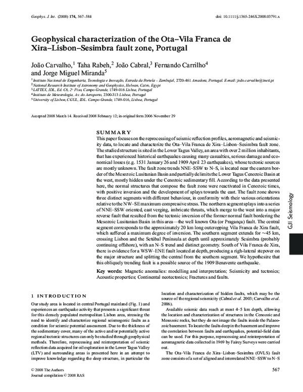
Figure 1. Location map and simplified geology (after Oliveira et al. 1992) of the study area. A-A′ – Ota and Vila Franca de Xira segments of the OVLS fault
zone; 1 – outcropping fault zone near Vila Franca de Xira; 2 – fault zone after the seismic reflection profiles interpretation and 3 – localities mentioned in the
text.
trending faults, extending along the western border of the Lower
Tagus Cenozoic Basin (LTCB) from approximately the Montejunto
massif (Fig. 2) at the north to Sesimbra at the south. It was selected as
a priority target for further investigation, based upon its near-surface
expression on the seismic reflection profiles at some locations, its
significance in the LTCB structural pattern and apparent relationship
with the regional seismicity, its closeness to Lisbon and its foreseen
seismic potential. This work discusses the interpretation and analysis
of recently reprocessed geophysical data mentioned above (seismic
reflection profiles, aeromagnetic data and seismicity data) to achieve
a better characterization of this fault zone.
The study area is located roughly 150–200 km north of the Iberia–
Africa plate boundary (the Azores–Gibraltar fracture zone) and has
suffered the effects of large historical earthquakes, which caused
severe damage and many casualties. The seismic activity comprises
relatively distant events, as the 1755 November 1 earthquake, one
of the largest historical earthquakes ever described (estimated magnitude ≥8.5; Martins & Mendes-Victor 1990). The 1755 event was
probably generated by N–S to NNE–SSW trending offshore structures located southwest of the Portuguese coastline (Zitellini et al.
1999, 2001; Baptista et al. 2003; Gràcia et al. 2003).
Besides the effects of the earthquakes generated in the southwestern offshore area, directly connected to the Iberia–Africa plate
boundary, the study region experiences a significant intraplate seismicity, attested by the occurrence of moderate to large local historical earthquakes, as in 1344, 1531 and 1909, with estimated magnitudes ranging from 6 to 7 (Mezcua 1982; Moreira 1984, 1985;
Oliveira 1986; Martins & Mendes-Victor 1990; Justo & Salwa
1998). Due to the scarcity of historical descriptions, the earthquakes in 1344 and 1531 are poorly located, being positioned in
the LTV based upon the destruction generated in the Lisbon area.
The 1531 event caused severe damage and many casualties in the
town of Lisbon, reaching an intensity of VIII–IX MM (Justo &
Salwa 1998).
The source of the M W = 6 (M S = 6.3) 1909 earthquake (TevesCosta et al. 1999; Dineva et al. 2002), which destroyed the village of Benavente (Fig. 1), is still unknown. The OVLS fault zone,
or the southern, hidden sector of the Azambuja fault (Fig. 2) are
the nearest, NNE–SSW trending, candidates (Cabral et al. 2003,
2004; Carvalho 2003). An alternative, as proposed by Stich et al.
(2005), is that the Benavente earthquake was generated by an ENE–
WSW trending blind thrust beneath the Tagus valley sedimentary
basin. This conclusion was drawn from the moment tensor inversion solution, which indicated almost pure reverse faulting with
nodal planes oriented (051◦ , 52◦ SE) and (242◦ , 38◦ NW) (Stich et
al. 2005) Later in this paper, we will propose a fault with compatible
characteristics.
The importance of local seismic sources to the seismic hazard of
the LTV area has been recently pointed out by many authors (e.g.
Peláez et al. 2002; Cabral et al. 2003, 2004; Vilanova et al. 2003;
Vilanova & Fonseca 2004; Carvalho et al. 2006). However, the low
instrumental seismicity, as a consequence of the small slip rate, the
poor earthquake location due to the sparse national network and the
presence of a thick sedimentary cover, does not show a clear relationship between the earthquakes locations and mechanisms and the
faults recognized at the surface. The geometry and topography of
the Tertiary and Mesozoic sedimentary basins also play an important role on local energy enhancement and site-effects, masking the
relationship between the historical events location based on seismic intensity studies and the earthquake sources. We propose that
the OVLS fault zone is responsible for most of the instrumental
seismicity registered in the study area.
�
C
2008 The Authors, GJI, 174, 567–584
C 2008 RAS
Journal compilation �
�Geophysical characterization of the OVLS fault zone
569
Figure 2. Used seismic and well data overlaid on a simplified geological map (after Oliveira et al. 1992). 1 – outcropping fault zone near Vila Franca de Xira;
2 – extent of the fault zone after Carvalho (2003); 3 – localities mentioned in the text; 4 – deep wells; 5 – oil industry seismic reflection profiles used for
structural mapping of the Lusitanian and Lower Tagus basins; 6 – seismic-reflection profiles used in this work to study the OVLS fault zone. 7 – seismic profiles
shown in Fig. 3. CF – Cercal fault; AZF – Azambuja fault; MM – Montejunto massif.
2 GEOLOGICAL SETTING
The study area includes part of the LTCB, a tectonic depression filled
with Cenozoic sediments that surrounds the lower reach of the Tagus
River, and the Arruda subbasin, which is part of the Mesozoic Lusitanian Basin (LB) (Fig. 1). A brief description of the former basin
can be found in Cabral et al. (2003) whereas the evolution of the
latter basin is described in Leinfelder & Wilson (1998), Rasmussen
et al. (1998), Carvalho et al. (2005) and others.
Several outcropping faults affect the LB whereas a few affect
the LTCB sediments. From geophysical data several other nonoutcropping fault zones were mapped in the LTCB (Cabral et al.
2003; Carvalho et al. 2006). For some of them, such as the Vila
Fanca de Xira, Azambuja, Pinhal Novo and Porto Alto faults, there
2008 The Authors, GJI, 174, 567–584
C 2008 RAS
Journal compilation �
�
C
is evidence of tectonic activity since the Pliocene (Cabral et al. 2003;
Carvalho et al. 2006).
The OVLS fault zone consists of a set of NNE–SSW to N–S trending, deep seated fault segments, located near the western border of
the LTCB. It comprises three main segments, mostly hidden under the Cenozoic sedimentary cover (particularly the recent alluvial
sediments of the Tagus River). The northern and central segments
behaved in the Mesozoic as normal faults flanking the LB in this
area and were inverted under the action of a NW oriented maximum
compressive stress in the Cenozoic. The southern sector reacted
differently to the regional compression, suffering minor inversion.
The northern segment of the fault zone corresponds to the N–S
to NNE–SSW trending Ota (or Pragança) fault, which extends
for ∼20 km from north of Ota to near Carregado, at the south
�570
J. Carvalho et al.
(Fig. 1 for locations). It is represented at the surface by an east dipping monocline, affecting the Tertiary sediments of the LTCB. The
central segment corresponds to the partially outcropping Vila Franca
de Xira fault, which extends for another ∼20 km to the SSW of Carregado (Fig. 1), being probably interrupted by a deep WSW–ENE
fault located north of Lisbon. This segment suffered the maximum
degree of tectonic inversion in the Cenozoic. The southern segment
of the OVLS fault zone extends for ∼45 km, crossing Lisbon and
the Setúbal Penı́nsula at depth until approximately Sesimbra (probably continuing offshore) with an N–S trend and distinct geometry.
It was barely inverted in the Cenozoic and is scarcely expressed
on the surface geology, where Neogene sediments predominate,
its presence at depth being inferred from the studied geophysical
data.
Among the three segments of the OVLS, Vila Franca de Xira
segment is better exposed on the surface geology. It consists of
a NNE–SSW trending complex, known from surface geology and
geophysical data (Domzalski 1969). It was generated in the Mesozoic as a large normal fault, bounding at the East the Arruda halfgraben of the LB (Rasmussen et al. 1998), later tectonically inverted
and moving with reverse slip component during the Neogene.
This segment of the fault zone is partially hidden under recent
alluvium of the Tagus river plain along most of its length. For 5 km
southward of Vila Franca de Xira, it outcrops as a steeply dipping
reverse fault, thrusting Jurassic rocks of the LB at the west, over tilted
Upper Miocene sediments of the LTCB, at the east. To the south, it is
intersected by a transverse NW–SE fault system (probably the Porto
Alto fault system of Carvalho et al. 2006) and is apparently offset
eastwards under the sediments of the Tagus alluvial plain through a
left-lateral stepover.
The extension of this segment of the OVLS fault zone further
south, as a blind thrust under the recent alluvia of the Tagus river
plain, is suggested by the eastwards dipping monocline that affects
the Tertiary sediments in this area. Geophysical data also show the
presence of an eastward dipping monocline and of a fault at depth
near the western bank of the Tagus river, south of Vila Franca de
Xira (Domzalski 1969; Walker 1983; GPEP 1986; Carvalho et al.
2006).
On its northern side, the extension of the fault zone a few kilometres northwards of Vila Franca de Xira is indicated by the presence of
outcropping faults affecting Jurassic rocks, and it is also suggested
by data from several oil-industry seismic profiles, where a few authors have interpreted a series of thrust faults as an imbricate system, merging at the main inverted normal fault to the west (Lomholt
et al. 1995; Cabral et al. 2003; Carvalho et al. 2006). However, due
to a gap in the seismic lines, the link between any of these faults to
the Vila Franca de Xira fault segment cannot be clarified.
Although the fault zone shows a significant geomorphic expression in this sector, particularly near Vila Franca de Xira, where it is
located along a steep slope at the western bank of the Tagus estuary,
no clear evidence of fault displacements affecting the Holocene alluvial deposits have been found so far (Carvalho et al. 2006). This
may be due to the low fault slip rate and the high river dynamics which can easily obliterate (erode and/or bury) any evidence of
recent surface faulting. Nevertheless, shallow geophysical data acquired recently suggests a vertical offset of about 5 m in Holocene
sediments (Carvalho et al. 2006).
3 I N T E R P R E T AT I O N O F T H E S E I S M I C
R E F L E C T I O N P RO F I L E S
3.1 Seismic reflection data reprocessing
The study area has partially been covered by seismic reflection data
acquired by the oil-industry from the 1950s to 1982 (see Table 1).
Due to advances in processing software and computing, reprocessing of this information was expected to provide an enhanced imaging
of the profiles. Therefore, over 60 seismic reflection profiles, corresponding to more than 800 km (Fig. 2), were reprocessed and
reinterpreted. A part of this data set was used to study the tectonic
and sedimentary evolution of the LB (Carvalho et al. 2005) and
for a better evaluation of the seismic potential of the study zone
(Carvalho et al. 2006).
In this study, additional lines in the Setúbal Peninsula were reprocessed and reinterpreted by the authors. Unpublished data, processed by Fairfield Industries in the right-hand margin of the Tagus
(courtesy of Mohave Oil), were also used. The complete data set
is summarized in Table 1. The details of the reprocessing can be
found in Table 2. All migrated stacked sections are of better quality than the original ones. The frequency content of the migrated
stacks from all the surveys is in the range of about 12–50 Hz. Depth
conversion was applied to all profiles, using the layer cake method
(Marsden 1989) with a velocity gradient for each layer, similarly to
Jaspen (1993) methodology, but without velocity anomalies, since
they may introduce false structures due to sparse well control.
3.2 Data interpretation
Several well logs and synthetic seismograms, VSP, aeromagnetic
and gravimetric reprocessed data were used in the reinterpretation of the seismic profiles, as well as recent geological information (Carvalho et al. 2005). All these data were georeferenced
and integrated in a GIS environment. After the identification by
Carvalho et al. (2006) of major structures affecting the upper
Table 1. Seismic acquisition parameters of the different seismic reflection surveys used in this work.
Seismic survey
Tejo
Samora
Arruda CPP
Arruda 80
Arruda 81
Barreiro
Bombarral
Caparica
Contractor
Date
Offsets (m)
Seismic source
Nominal fold
Geco-Prakla
CGG
Prakla-Seismos
CGG
CGG
CGG
Quest Party
CGG
1978
1979
1954-1955
1980
1981-1982
1963
1979
1981
100–1250
100–2450
20–240
100–1250
120–1530
100–2450
450–1600
120–1530
Air-gun
Vibroseis
Dynamite
Vibroseis
Vibroseis
Vibroseis
Geosel
Vibroseis
24
24
1
24
24
24
12
24
Note: The surveys from Arruda were recently reprocessed by Fairfield Industries using pre-stack time migration (courtesy of Mohave
Oil). All other surveys were reprocessed by the authors, except profile C6 from the Caparica survey, which was kindly reprocessed by
DECO Geophysical.
�
C
2008 The Authors, GJI, 174, 567–584
C 2008 RAS
Journal compilation �
�Geophysical characterization of the OVLS fault zone
Table 2. Principal steps applied in the processing of the seismic reflection
data.
Processing step
Butterworth passband
Spherical divergence
Mute
Elevation and
refraction statics
Deconvolution
Velocity analysis
Residual statics
Velocity analysis
DMO
Velocity analysis
NMO correction+stack
Phase-shift migration
Post-stack processing
Parameters used
15–250 Hz, 18dBoct−1
Time2 × velocity2
First arrivals
Velocity models obtained from
original sections
Prediction length:10 ms, operator
length: 250 ms
Constant velocity panels
Maximum allowable shift 8 ms
Constant velocity panels
FK DMO
Constant velocity panels
Stretch mute 70 per cent
Interval velocities
Time-variant butterworth, amplitude
equalization, spatial noise filter
Note: The Arruda 80 and 81 surveys were reprocessed by Fairfield
Industries, using pre-stack time migration.
Neogene, several stacked sections were selected for a detailed study
of the OVLS fault zone (Fig. 2). The faults were identified by visual inspection of the stacks using seismic attributes, by verifying
fault consistency from line to line and the observation of 3D horizon
structural maps. Potential field data were plotted over the seismic
profiles and used to confirm major faults in the Mesozoic and Palaeozoic rocks, as well as other geological structures. Further profiles
and surveys than the ones studied by Carvalho et al. (2005, 2006)
were included in this work to enlighten the north and southwards
prolongation of the fault zone. Fig. 3 shows the OVLS fault zone in
several seismic profiles.
Evidence of the fault zone at its northern sector, south of Alcoentre (see Fig. 1 for location) can be seen in a series of faults with
different geometries affecting the Meso-Cenozoic and Palaeozoic
cover. The deformation of the Mesozoic and Cenozoic sedimentary
cover produced by this fault segment is also apparent in seismic
profiles located further south, as in the example shown in Fig. 3(a)
(see Fig. 2 for location).
In its sector near Vila Franca Xira, the OVLS fault zone presents
a greater degree of inversion, as evidenced in seismic section of
Fig. 3(b). This section is consistent with the statement by Carvalho
et al. (2006) that near the western bank of the Tagus river, the Jurassic rocks rapidly drop from the surface to a depth of more than
300 m.
One or two kilometres south of Vila Franca Xira, the seismic lines
available have a strike subparallel to the fault itself, making them
barely suitable for studying this structure. The undulated geometry
of the reflectors in the seismic sections located to the south of section
in Fig. 3(b) (Figs 3c and d) is due to distinct causes, where the
interference of the OVLS fault zone is difficult to recognize.
In the section of Fig. 3(c), the occurrence of a thick Cenozoic
sedimentary sequence (0.5–1.5 km) along the profile suggests that
it is located on the footwall of the Vila Franca de Xira fault segment,
which probably passes immediately to the west of the profile. In
fact, surface geology (Zbyszewski et al. 1981) shows that Jurassic
sediments outcrop only 250 m west of central part of the profile. The
observed folding and faulting of the seismic horizons is probably
produced by a partially mapped NW–SE transfer fault (Zbyszewski
et al. 1981), which intersects and laterally offsets the OVLS fault
zone in this area.
2008 The Authors, GJI, 174, 567–584
C 2008 RAS
Journal compilation �
�
C
571
The profile shown in Fig. 3(d), located to the south of the previous profile, curves towards the west and intersects a fault zone
that has different characteristics. The vertical offsets are small, and
the observed geometry across the Cenozoic sediments suggests a
prevailing strike-slip behaviour in this area. The folding observed
in Fig. 3(d) partially results from a change in the trend of the seismic
section relatively to the strike of the sedimentary sequence.
South of the location of the profile shown in Fig. 3(d), the OVLS
fault zone is not recognized in the stacked seismic sections available, which are oriented approximately E–W. The analysis of the
aeromagnetic data (see Section 4) indicates that it bends westwards
south of Fig. 3(d). This may explain the different characteristics of
the fault zone detected in Fig. 3(e), which possibly corresponds to
the southern termination of the OVLS fault segment located to the
north. This suggests that this structure is probably segmented in this
area, and we shall see in the following discussion that it is most
likely due to a WSW–ENE trending fault that locally offsets the
OVLS fault zone.
According to the interpretation of aeromagnetic data (presented
in the Section 4), the fault zone bends towards the west and then
acquires a N–S trend, crossing at depth the area of the city of Lisbon
and continuing south, into the Setúbal Penı́nsula. Another seismic
reflection survey acquired in 1981 in this southern area was therefore
reprocessed and reinterpreted to confirm the fault zone location according to the aeromagnetic data. Fig. 3(e) shows a stacked section in
this area. The fault zone is recognized in this seismic section as a set
of two nearly vertical faults affecting the Mesozoic and Palaeozoic
units, though some deformation also affects the Cenozoic layers.
The seismic data, therefore, supports the southern prolonging of the
OVLS fault zone into the Setúbal Penı́nsula although with different
geometry and kinematics.
4 A E R O M A G N E T I C D AT A
I N T E R P R E T AT I O N
The aeromagnetic data was acquired during 1969 by Fairey Surveys
Limited throughout the Portuguese Atlantic margin. The altitude of
the flight was 600 m, with flight lines oriented W–E and spaced approximately 2.5 km. Several tie lines were oriented in the NW–SE
and NE–SW directions. This aeromagnetic survey completely covers the studied area. The data were available in the form of magnetic
anomaly contour maps at the 1 : 200,000 scale, with flight lines
overlaid (Domzalski 1969). The data were digitized at the crossings
of the contour lines (5 nT contour interval) with the flight lines.
The IGRF model was then extracted and substituted by a more
recent model, and the corrected data were reduced to pole (RTP)
(Baranov 1957). The result is presented in Fig. 4. The RTP aeromagnetic map was subjected to intensive analysis to detect the subsurface tectonic structures that affect the study area and correlate
them with the results obtained from the seismic analysis. Since the
metamorphic and igneous rocks that constitute the Palaeozoic basement usually have a stronger magnetic signature than Mesozoic and
Cenozoic sediments, we also expected to detect with the magnetic
interpretation some structures affecting the basement, which could
not be imaged with the seismic reflection profiles.
Several magnetic interpretation techniques were carried out,
which are explained in the next sections. First, to provide auxiliary
information in the interpretation of the seismic reflection profiles,
such as the existence of deep rooted fault zones, igneous structures,
etc. Secondly, through 2.5-D modelling with constrains from seismic, well and outcrop data, to provide a regional setting for the
�572
J. Carvalho et al.
Figure 3. Sections of seismic reflection profiles shown in two-way-time (top), interpreted depth converted sections (centre) and respective magnetic interpretation
(bottom), showing different aspects of the OVLS fault zone. See Fig. 2 for location. In seismic and magnetic interpretations black continuous lines indicate
geological faults. The seismic interpretation is the preferred and final model: Blue line – top of Jurassic; Green line – top of Lower Cretaceous. Red dashed
line- top of Palaeozoic. (c): A – NNW–SSE fault zone (see text); BF – Benavente Fault zone (see text). Magnetic interpretations presented are horizontal and
vertical gradients (upper panel of bottom figure) and 2D Euler deconvolution (lower panel). Structure indices from Euler deconvolution are presented in km.
Time seismic sections of parts (a) and (b) are courtesy of Mohave Oil. Part (e) is a courtesy of Deco Geophysical.
study area, in particular where no reflection data are available. Finally, by the computation of gradient, analytical signal and Euler
deconvolution maps and sections, to infer the total extension of the
fault zone, particularly at depth.
4.1 Construction of a structural map
Potential field data are important to delineate the tectonic fault trends
using, for example, the theory of Grant & West (1965) and Linsser
(1967) technique. The first horizontal gradient method was applied
to the RTP aeromagnetic map. The peaks of the gradient curves
were plotted and connected together to show the possible structural
lines, and a structure map was obtained through this process (not
shown here).
From a close examination of this structural map, it can be inferred
that the OVLS fault zone has a large regional extent, extending
from the southern to the northern part of the studied area. It trends
approximately N–S at the southern part and changes to a NNE–SSW
direction in the north. This is in agreement with the results obtained
from the seismic reflection interpretation.
4.2 2.5-D modelling and analytical signal methods
The magnetic potential at a point with coordinates (x, y, z) due to an
arbitrary volume of magnetic material can be expressed as (Talwani
& Ewing 1960):
� �
�
� z2 � g2 (z)
x0
z0
−1
gz = G�ρ
dz 0
(1)
dx
dz
=
tan
0
0
2
2
z 0′
g1 (z) x 0 + z 0
z1
c
�
C
2008 The Authors, GJI, 174, 567–584
C 2008 RAS
Journal compilation �
�Geophysical characterization of the OVLS fault zone
573
Figure 3. (Continued.)
where �ρ is a constant, G the magnetization vector and (x o , y o ,
z o ) are the coordinates of any point within the potential body.
Computations of the magnetic effects by models with complex
geometry were carried out using commercial software (GM-SYS
1995). 2.5-D magnetic modelling was applied to a set of four profiles
perpendicular to the strike of the magnetic anomalies and covering
the surveyed area (see location in Fig. 4). The purpose of these long
profiles is to provide a regional setting for the different sectors of
the OVLS fault zone.
The main objective was the geometry of the top of the basement
and the presence of igneous structures or salt bodies, all interpreted
as major contrasts in magnetization. In the area, the basement is
formed by Palaeozoic igneous and metamorphic rocks. The results
were checked with the analytical signal technique (Nabighian 1972)
along a set of profiles. The latter method is often used to detect
magnetic sources locations independent of ambient earth magnetic
parameters and is currently applied for the above purposes (e.g.
2008 The Authors, GJI, 174, 567–584
C 2008 RAS
Journal compilation �
�
C
Roest et al. 1992; Wen-Bin et al. 2007). The depth to basement
and location of igneous and salt bodies (but not faults, since these
are our main target) were also analysed in all models from outcrop geological information, seismic reflection and well data, where
available.
From the observation of the 2.5-D model profiles (Figs 5a–d),
it can be noted that the depth to the basement rocks varies significantly. The mean depth ranges between 0.3 and 3.3 km, and a sharp
discontinuity that we can associate with OVLS, is found along the
profiles. This discontinuity extends from north to south, crossing
the various profiles and emphasizing its regional extent. The vertical offset and its importance as a Mesozoic basin boundary structure
are clear in profile 2 (Fig. 5b). In the southern profiles (profiles 3
and 4, Figs 5c and d), it no longer presents growth fault characteristics, showing a distinct Mesozoic and Cenozoic behaviour. Other
major geological faults which are known to affect the basement,
show up in the magnetic models such as the Nazaré fault (profile 2)
�574
J. Carvalho et al.
Figure 3. (Continued.)
and the Pinhal Novo fault (profiles 3 and 4). The magnetic susceptibilities used in the direct magnetic modelling have been listed in
Table 3.
geneity can be written in the form
(x − x0 )∂T/∂ x − (y − y0 )∂T/∂ y + (z − z 0 )∂T/∂z = N (B − T),
(2)
4.3 Euler deconvolution method
The Euler deconvolution method, published by Reid et al. (1990)
tries to determine source positions and depths of the magnetic contrasts. Thompson (1982) showed that the relation of Euler’s homo-
where (x 0 , y 0 , z 0 ) is the position of the magnetic source whose total
field T is detected at (x, y, z). The total field has a regional value of
B. The degree of homogeneity N may be interpreted as a structural
index (SI), which is a measure of the rate of change of the field with
distance. For the index of sloping magnetic contact, the appropriate
�
C
2008 The Authors, GJI, 174, 567–584
C 2008 RAS
Journal compilation �
�Geophysical characterization of the OVLS fault zone
575
Figure 3. (Continued.)
form of Euler’s equation is
(x − x0 )∂T/∂ x − (y − y0 )∂T/∂ y + (z − z 0 )∂T/∂z = A,
(3)
where A incorporates amplitude, strike, and dip factors which cannot
be separated easily.
This technique, which is applied to gridded data, measures the
gradients, locates square windows of magnetic field and gradient
values and determines structural windows. The results are plotted in
map view (x, y), using a symbol related to depth z. The Euler deconvolution method has been applied using 0.5 magnetic step indeces
to indicate the depth to the basement rocks and their structures.
The results are shown in a 2-D map, where faults inferred from
seismic data are also overlaid (Fig. 6a), and in a 3-D perspective
(Fig. 6b). The 3D Euler deconvolution shows that the OVLS ex2008 The Authors, GJI, 174, 567–584
C 2008 RAS
Journal compilation �
�
C
tends from relatively shallow (200–300 m) to deep (5–6 km) depths
in agreement with the seismic reflection data interpretation. The SI
2-D map indicates once more the regional extension of the OVLS
fault zone. It extends from the north to the south of the studied area,
varying from a NNE–SSW direction north of Lisbon to an approximate N–S direction to the south of the city. These results agree with
the structure deduced from the trend analysis of aeromagnetic data
and seismic reflection interpretations.
4.4 Correlation of magnetic and seismic interpretations
The 2D Euler deconvolution, gradient and analytical signal interpretation techniques were applied to magnetic profiles coincident the
seismic reflection lines. The faults were derived using the 2-D Euler
�576
J. Carvalho et al.
Figure 3. (Continued.)
deconvolution and the horizontal gradient. The results are presented
in Figs 3(a)–(e), below the correspondent time and depth seismic
sections. Generally, there is a good agreement between the seismic
and magnetic interpretations.
Some differences found between the two interpretations arise
from the fact that the two methods respond to different rock properties, and the seismic method is more suitable to image structures in
the sedimentary cover, whereas the magnetic method is most appropriate to detect structures affecting the metamorphic and igneous
Palaeozoic basement. Since the seismic data provides an increased
resolution when compared with the magnetic data, we favour the
seismic interpretation. However, the aeromagnetic data were very
helpful since they confirmed the seismic interpretation in areas
where the seismic signal-to-noise ratio was poor, including when
the basement was shallow, and in areas where no seismic data was
available. The OVLS fault zone, resulting from the integrated inter-
pretation of geological, aeromagnetic and seismic reflection data is
presented in Fig. 7 in a perspective view with the location of the full
seismic reflection profiles, whose details are shown in Fig. 3.
5 S E I S M I C I T Y D AT A
Relocated epicentres from the period 1970–2000 (Carrilho et al.
2004), where the average error (90 per cent confidence level) in the
epicentral location is 5 km, were used to help to locate the major
active tectonic structures and eventually the OVLS fault zone in
the study area (Fig. 8). Epicentres were relocated with the software
Hypocent (Lienert et al. 1986; Lienert & Havskov 1995), which
implements a Geiger iteration scheme, with a centred, scaled and
adaptively damped least-squares technique, to find the solution. The
1-D velocity model is the one routinely used for locating hypocenters
�
C
2008 The Authors, GJI, 174, 567–584
C 2008 RAS
Journal compilation �
�Geophysical characterization of the OVLS fault zone
577
Figure 4. Aeromagnetic survey of the study area, showing the location of the regional profiles presented with 2.5-D modelling. A-A′ V. F. de Xira and Pragança
sectors of the OVLS fault zone, after the seismic reflection profiles interpretation and geological outcrop studies; 1 – 2.5-D magnetic models; 2 – coastline; 3 –
localities mentioned in the text; 4 – oil industry seismic-reflection profiles used for structural mapping of the basin. PN – Pinhal Novo fault; C – Cercal fault;
LR – Lourinhã fault; N – Nazaré fault; PS – southern prolonging of Ponte de Soure fault (satellite lineament, Cabral & Ribeiro 1988).
in Portugal mainland, which is based in deep refraction data (e.g.
Mueller et al. 1973; Mendes-Victor et al. 1980; Moreira et al. 1980).
The OVLS fault zone setting proposed in this paper, inferred from
seismic reflection and aeromagnetic data interpretation, is shown in
Fig. 8(a), together with the epicentre locations plotted with horizontal error ellipses (major error axis less than 8 km). This figure also shows the location of the cross-section (A-A′ ) shown in
Fig. 8(b) representing the OVLS fault zone central sector (SC,
Fig. 8a). In Fig. 8(a), the OVLS fault zone seems to control the distribution of the seismicity in the studied area. We can observe that the
vast majority of the events are located astride or to the west of the proposed fault zone location. Epicentral locations using other seismic
catalogues (e.g. ISC, On-line Bulletin, http://www.isc.ac.uk/Bull,
Internat. Seis. Cent., Thatcham, United Kingdom 2001) also support this conclusion.
With the exception of five events located in the Tagus estuary, the
seismicity observed further east in Fig. 8 is associated with other
structures, located outside the study area. Of the five events in the
Tagus estuary, the northernmost is probably associated with a NW–
SE oriented fault system, detected by seismic reflection (Cabral et al.
2003; Carvalho et al. 2006; red lines, Fig. 6). The other four events
can hardly be associated with any other known structure, though
the Pinhal Novo fault may be a potential candidate. However, the SI
map (Fig. 6) has several solutions in the same area suggesting other
possible seismic sources.
2008 The Authors, GJI, 174, 567–584
C 2008 RAS
Journal compilation �
�
C
Other Catalogues (Martins & Mendes-Victor 1990; Sousa et al.
1992), which contain events from the period 63 AD until 1992,
show a similar distribution of seismicity (not shown here), with
most of the earthquakes located westwards of the surface trace
of the OVLS fault zone. The earthquake data catalogue used in
this study, though covering a short period of time, has the advantage of possessing the information on epicentre location errors
and parameters, which allows a good control of the quality of the
solutions.
Hypocentre solutions have a larger error than epicentral solutions
and do not allow yet a reliable analysis of the deep fault plane geometry from earthquakes hypocentre location. However a tentative
correlation was tried. In Fig. 8(b), earthquakes located in a corridor
containing the central sector of the OVLS (area between straight
lines in Fig. 8a, SC) are plotted over a cross-section of the same
sector of the fault zone. The obtained result supports the above referred distribution of the seismicity, which is in fact associated with
the downwards projection of the OVLS fault zone or located to the
west.
6 DISCUSSION
The studied seismic reflection data show that the OVLS fault zone,
partially expressed at the surface as faults affecting Mesozoic and
Cenozoic sediments or as a monocline in Cenozoic rocks, extends
�578
J. Carvalho et al.
Figure 5. Schematic models of the regional magnetic profiles. PS – southern projection of Ponte de Soure fault (satellite lineament, Cabral & Ribeiro 1988); C
– Cercal fault; N – Nazaré fault; LR – Lourinhã fault; PN – Pinhal Novo fault; OVLS – Ota–V. F. Xira–Lisbon–Sesimbra fault zone; CVL – Vulcanic Complex
of Lisbon. For fault locations in map view please see Fig. 4.
�
C
2008 The Authors, GJI, 174, 567–584
C 2008 RAS
Journal compilation �
�Geophysical characterization of the OVLS fault zone
579
Figure 5. (Continued.)
Table 3. Magnetic susceptibility values used for the basement in the 2.5-D modelling of the aeromagnetic profiles shown in
Fig. 5.
End values of magnetic susceptibility
Profile no.
Orientation
Mean magnetic susceptibility in SI units
Minimum
Maximum
Profile 1
Profile 2
Profile 3
Profile 4
NNW–SSE
NW–SE
W–E
W–E
0.0086
0.0084
0.021
0.019
0.01
0.0098
0.035
0.030
0.0072
0.007
0.0089
0.0085
Figure 6. (a) Structural index of the RTP aeromagnetic anomaly map, obtained from Euler deconvolution. 1- coastline and river Tagus; 2- location of the Ota
and Vila Franca de Xira faults in the Neogene, obtained from seismic reflection data (after Carvalho et al. 2006); 3- proposed location of the OVLS fault zone
in the basement after seismic and magnetic data interpretation. (b) 3-D euler deconvolution of the same area showing the near surface aspect of the fault and
its deep rooting.
2008 The Authors, GJI, 174, 567–584
C 2008 RAS
Journal compilation �
�
C
�580
J. Carvalho et al.
Figure 7. Perspective view of the OVLS and BF fault zones shown together
with the seismic reflection profiles, after the integrated interpretation of
seismic, aeromagnetic, well and geological outcrop data. 1 – Details of the
seismic profiles shown in Fig. 3; 2 – fault planes; 3 – coastline; 4 – localities;
5 – Limits of the council of Lisbon. Courtesy of dGB Earth Sciences.
roughly from the latitude of Alcoentre (see Fig. 2 for location) till
about 15 km north of Lisbon, consisting of two fault segments,
usually referred to as the Ota (or Pragança) fault at the north and
the Vila Franca de Xira fault at the south, which controlled the
development of the Arruda half-graben of the LB in the Mesozoic
and were strongly inverted during the Cenozoic compressive stress
regime.
According to aeromagnetic data, at that location (site B, Fig. 8a),
the fault zone bends westwards, outside the coverage of the available
seismic reflection data, and then continues southwards with a N–S
strike. Seismicity data (Fig. 8) also suggest this bend of the fault
zone, since most of the earthquake locations move accordingly to
the west. Unfortunately, there is not seismic reflection data available
in the Lisbon area, and we cannot follow the westward bend of the
fault zone.
At location B, the OVLS fault zone characteristics in the seismic
reflection profiles also change (compare Figs 3a and b with Fig. 3d).
In spite of the inadequate orientation of sections 3c and d relative to
the fault strike, from their interpretation, it can be inferred that the
vertical offsets in Cenozoic and Mesozoic rocks clearly diminish
southwards. South of seismic section 3d (Fig. 2), sited to the south
of location B (Fig. 8), the fault zone is no longer recognizable in the
available seismic profiles, also supporting that it probably is segmented at that location, in agreement with magnetic and seismicity
data.
Keller & McClay (1995) carried out 3-D sandbox modelling of
positive inversion of extensional fault systems, and one of their
conclusions is that fault displacements have important variations
along-strike. These characteristics are found in the OVLS fault zone.
The degree of inversion found at the latitude of Vila Franca de Xira
(Fig. 3b) is considerably greater than at around the latitude of Ota
(Fig. 3a) and further south (Figs 3c–e).
Keller & McClay (1995) further conclude that extension and inversion produce strongly segmented faults, with fault segments dying out laterally or overlapping across displacement transfer zones
in the form of relay ramp structures. Therefore, the segmentation
of the OVLS fault zone is in agreement with 3-D scaled analogue
models and with data from other areas, which have undergone positive inversion (e.g. Knott et al. 1995). The fact that a fault segment
continues for a few kilometres (5–6 km) southwards of the transfer
zone location B (Figs 7 and 8), is compatible with the results of
Keller & McClay (1995).
As stated above, according to the magnetic and seismicity data,
the OVLS fault zone jumps westwards at location B, through a right
lateral stepover about 9–10 km wide (outside the coverage of the
seismic reflection data). Then it strikes N–S towards Lisbon, crossing the city area at depth, and enters the Setúbal Penı́nsula (Figs 7
and 8), where seismic reflection data are also available, being detected until near the village of Sesimbra, at the south (Fig. 1). The
seismic reflection data in the Setúbal Peninsula show that the fault
zone cuts the Palaeozoic, Mesozoic and Cenozoic geological units,
although producing relatively small vertical offsets in the Cenozoic
(Fig. 3e). The small deformation of the Cenozoic horizons contrasts
with the much larger deformation evidenced in the seismic profiles
located to the north of Lisbon, where the inversion of the extensional Mesozoic structures is large. This indicates that this southern
segment of the OVFXS fault zone in the Palaeozoic basement was
subjected to small dip-slip reactivation in the Cenozoic compressive tectonic regime, strongly contrasting with the behaviour of the
northern Vila Franca de Xira and Ota segments.
The bend or segmentation of the OVLS fault zone at location
B approximately coincides with the eastern sector of a probable
ENE–WSW trending, north verging reverse fault at depth, which
controls the elongated Sintra–Caneças antiformal structure located
to the west, bordering the northern limit of the Sintra massif (Cabral
2008). This suggests interference between the two structures, with
the OVLS fault zone probably offset by the WSW–ENE fault.
Some evidence of the eastwards prolonging of the WSW–ENE
fault zone under the Holocene sediments of the Tagus river alluvial
plain comes from the seismic reflection data (seismic profiles S1,
229, 223, S6 and 240, from the Samora and Barreiro surveys described in Table 1). The profile in Fig. 3(c) also shows two faults
compatible with this structure. The northernmost (signalled A in the
figure) probably corresponds to an approximate NW–SE trending
fault of the above referred Porto Alto fault system (Carvalho et al.
2006). The other fault with down throw to the NNE (signaled BF
in Fig. 3c) may be connected with the WSW–ENE fault zone under
discussion. The interpretation of the profiles available in the area
is thus compatible with a structure with the expected location and
geometry, though the detectable vertical offset of this fault is only
of several tens of metres in the Cenozoic layers. Fig. 8 also shows
that a few earthquakes can be associated with this fault.
Stich et al. (2005) have recently calculated a moment tensor solution of the 1909 Benavente earthquake, evidencing a dip-slip reverse component with nodal planes presenting strike/dip/rake of
N51◦ E/52◦ /83◦ and N242◦ E/38◦ /99◦ . Therefore, the proposed eastern prolonging of the WSW–ENE fault zone presented here is a
�
C
2008 The Authors, GJI, 174, 567–584
C 2008 RAS
Journal compilation �
�Geophysical characterization of the OVLS fault zone
581
Figure 8. (a) Seismicity in the study region and adjacent areas for the period 1970–2000 (after Carrilho et al. 2004), plotted with error ellipses of epicentre
location. All events have a major axis of error less than 8 km. Also shown are the locations of the OVLS fault zone and the Benavente fault (BF) proposed
in this work (dash and dash-dot, west and east of the Tagus river, respectively). 1- coastline; 2- delimitation of the different sectors of the OVLS fault zone.
SC- central sector of the OVLS fault zone. A-A′ – cross-section presented in part (b). (b) Geological cross-section obtained by an integrated interpretation of
magnetic, seismic, well and geological outcrop data, with relocated epicentres of the central sector of the fault zone (location in a). Note the association of the
projected fault plane and several events. 1 – Palaeozoic basement; 2 – Mesozoic; 3 – Cenozoic.
possible candidate for the location of the 1909 Benavente earthquake, as it trends approximately parallel to the first aforementioned
nodal plane. We hereinafter refer to this structure as the Benavente
fault zone.
The models of the magnetic profiles shown in Fig. 5 confirm the
interpretation of the seismic reflection profiles and show with simplicity several aspects of the regional structure of the study area.
The model of profile 2 shows that the border of the Mesozoic LB in
this area is represented by the northern segment of the OVLS fault
zone (see Fig. 4 for location). Since magnetic data respond mainly
to variations in the basement (Palaeozoic igneous and metamorphic
rocks) properties and structure, we have not marked any faults in
the Mesozoic and Cenozoic units, though the examples of Fig. 3
show that the magnetic method is also able to detect major faults
in the sedimentary column, probably due to the large volumes of
sedimentary material. However, from the seismic data (Figs 3a and
b), we can see that the fault was reactivated in the Cenozoic, with
splay faults probably nucleating from the tip of the previous normal fault and propagating towards the east, as suggested from analogue scaled models (Eisenstadt & Withjack 1995; McClay 1995;
Eisenstadt & Sims 2005).
Profile 1, also crossing the northern sector of the OVLS fault zone,
shows that the thickness of the Mesozoic sediments diminishes to
the north, with the LB’s major boundary fault corresponding here
to the Cercal (or Montejunto) fault (Carvalho et al. 2005). On the
contrary, the LTCB shows an increased thickness, though part of the
modelled anomaly source maybe caused by lithological variations
inside the basement, as a maximum thickness of 4 km of sediments
at this location is not credible.
A few kilometres southward of the OVLS fault segmentation at
location B, profile 3 (Fig. 5c) shows that the fault zone looses expression, evidencing a much smaller vertical offset. Further south, in
the Setúbal Peninsula, profile 4 (Fig. 5d) evidences that the southern
segment the OVXLS fault zone produces a much reduced vertical
offset in the Palaeozoic basement although seismic data suggests
2008 The Authors, GJI, 174, 567–584
C 2008 RAS
Journal compilation �
�
C
(Fig. 3e) a larger vertical offset. Though this fault may probably
have been a pre-inversion fault, seismic (no growth is observed in
Jurassic sediments) and aeromagnetic data show that it was not the
Mesozoic Basin boundary fault zone, as the fault segments to the
north of location B were.
Reactivation of previous weakness zones is a common situation.
At location B, the OVLS fault zone is apparently right-laterally offset across the proposed Benavente fault, and southwards it changes
to an N–S strike (Fig. 7), which is a less favourable orientation for
reactivation with positive inversion under the Cenozoic compressive stress regime. The fault becomes more high-angle, which also
makes it less favourable for a positive inversion reactivation (Lowell
1995).
Under a change in the stress regime, normal faults with listric
geometry striking perpendicular to a horizontal maximum compressive stress should be reactivated with a predominant reverse movement component (Lowell 1995; Sibson 1995). Steep faults with a
reduced angle to that maximum compressive stress are commonly
reactivated with a predominant strike-slip movement component
(Lowell 1995). When the angle of pre-existing faults with the direction of the maximum compressive is relatively high, transpression
is the most common mode of inversion (Lowell 1995).
Furthermore, when the strike-slip component is dominant, relatively high-angle normal faults can be reactivated and no new structures need to be created. When reverse kinematics dominates, some
of the older faults may be reactivated, and new reverse structures
are formed. The geometries inherited from the previous extensional
episode are of great importance to the positive inversion structures
(Yamada & McClay 2003). These empirical observations, found
throughout the world, seem to be in agreement with the behaviour
of the OVLS and Benavente fault zones.
The northern and central segments of the fault (from location
B to approximately the town of Ota) trend NNE–SSW to N–S, at
a high-angle to the dominant Cenozoic compressive stress, which
trended NW–SE (Ribeiro et al. 1990). Here, clear reverse structures
�582
J. Carvalho et al.
affecting Cenozoic sediments can be observed (Figs 3a and b), indicating that, as expected, the reverse component predominates. As
referred above, in this sector some of the Mesozoic basin boundary faults have been inverted, namely the Vila Franca de Xira and
Ota (or Pragança fault). A variable degree of inversion is found for
several previously normal faults that present the same strike. A selective reactivation of previous normal faults is common in positive
inversion situations (e.g. Lowell 1995; Sibson 1995).
The N–S oriented southern segment of the fault trends at an angle
of approximately 45◦ to the usually admitted strike of the compressive stress in the Cenozoic (Ribeiro et al. 1990, 1996). This has
been considered the limit between a predominantly reverse inversion and dominant strike-slip reactivation (Lowell 1995). Therefore,
in this segment of the fault zone, it is expected the reactivation of preexisting normal faults with mostly strike-slip movement component
and without the development of new reverse structures, corresponding to incipient inversion. This is what we observe on the seismic
reflection sections of the Setúbal Penı́nsula (see Fig. 3e), which bear
no seismic signature of important reverse structures in the Cenozoic
sedimentary cover.
Finally, some considerations should be made about the possibility
that the OVLS fault zone is an active seismogenic source and, if
so, of its implication on seismic potential assessment. The present
tectonic activity of the OVLS fault zone implies the reactivation
of this structure under the present stress regime, which is oriented
approximately NW–SE to WNW–ESE in the study area (Ribeiro
et al. 1996; Borges et al. 2001). As stated before, the fault zone
seems to control the distribution of the seismicity in the study area
(Fig. 8a). The geological cross-section presented in Fig. 8(b), located
in the central sector of the OVLS fault zone and with epicentres
from this sector overlaid, results from the integrated interpretation of
seismic reflection, aeromagnetic, well and geological outcrop data.
The downward projection of the OVLS confirms that the epicenters
distribution is indeed connected to the westwards dip of the fault
surface and with other structures located to the west (Fig. 8b).
Other evidences suggest that the OVLS fault zone is very probably active. From outcrop geological studies, the fault is known to
affect upper Miocene sediments and it is parallel to other structures in the LTCB, which also affect sediments of this age and are
known to be active in the Pleistocene, as the Azambuja fault (Cabral
et al. 2003, 2004). Moreover, geophysical data recently acquired
near Vila Franca de Xira and well data (Carvalho et al. 2006) suggest that in this segment, the fault cuts Quaternary sediments and a
vertical offset of 5m was estimated.
7 C O N C LU S I O N S
The aim of this work was to investigate a regional fault zone that is
known to exist in the LTV, from geological and seismic reflection
data. This structure has been previously considered as an important
structure in the regional seismotectonics framework and a possible
source of the significant seismicity that affects the study region.
In its northern and central sectors, it corresponds to an approximately NNE–SSW to N–S oriented, reverse fault zone that borders
the LB and the LTCB, approximately from north of Ota till about
8–9 km south of Vila Franca de Xira. Reprocessed and reinterpreted
seismic reflection, aeromagnetic and seismicity data presented here
confirm that the fault zone extends along that distance, for about
35 km. In these sectors, the fault comprises two segments resulting
from the inversion of previous normal boundary faults of the Mesozoic LB, namely the Vila Franca de Xira fault at the south and the
Ota (or Pragança) fault at the north.
To the south, according to the interpreted aeromagnetic data, the
OVFXS fault zone does not end about 8–9 km south of Vila Franca
de Xira, as previously thought, but it bends westwards as it crosses
the proposed WSW–ENE trending Benavente fault and continues
south with an approximate N–S strike, under the city of Lisbon and
crossing the Setúbal Peninsula until the village of Sesimbra.
This previously unknown segment of the OVLS fault zone, at least
45 km long, is supported by seismic reflection data in the Setúbal
Penı́nsula and is also sustained by earthquake distribution data. The
former data show that the fault zone is steeper in this segment and
that the deformation that it produces in the Cenozoic sediments is
considerably less than in the northern segments. The difference in
character of the fault from north to south is also inferred from 2.5-D
magnetic modelling. Epicentre locations are mostly located to the
west of the three sectors, which, associated with the continuity of
Euler solutions of the aeromagnetic data, suggest that we have a
single major fault zone, though segmented.
In face of this, we propose that the fault zone should be cited as
the Ota–Vila Franca de Xira–Lisboa–Sesimbra (OVLS) fault zone.
Interpretation of seismic and magnetic data shows that in all segments the fault extends to at least 5–6 km depth. In spite of poor
hypocenter locations, an association between the downdip prolonging of the fault surface, as seen from the seismic data in the first
2–3 km, and the hypocentre solutions at depth is apparent. Moreover, this structure seems to delimit a crustal domain located to the
west, characterized by a higher seismic activity.
The newly proposed WSW–ENE Benavente fault zone was deduced from the observation that the bend of the OVLS fault zone coincides with the eastern end of the Sintra–Caneças structural alignment, and that the related fault at depth apparently continues further
east under the Tagus river alluvial sediments, as suggested by seismic
reflection data. A moment tensor solution recently computed for the
1909 Benavente earthquake points to an almost pure reverse movement on a fault with a similar strike. Together with the fact that the
proposed Benavente fault zone passes 1–2 km south of Benavente,
makes it a candidate structure as the source of the 1909 earthquake.
A more refined interpretation of the section of this fault under the
Tagus Holocene alluvia, using seismic reflection and potential field
data, needs to be carried out.
The results presented here point to the importance of local seismogenic sources in the seismic hazard estimation of the study area,
in agreement with previous work of several authors (Peláez et al.
2002; Cabral et al. 2003, 2004; Vilanova & Fonseca 2004; Carvalho
et al. 2006). Further studies, using more reprocessed seismic reflection data, topographic, satellite interferometry, gravimetric and
Moho data are currently underway to provide a better understanding
of the study area.
AC K N OW L E D G M E N T S
Part of this work was funded by the portuguese Foundation for
Science and Technology and the EC under Project Sismotecto
(POCI/CTE-GIN/58250/2004). The Department of Prospecção e
Exploração de Petróleos from the Direcção Geral de Geologia e Energia is greatly acknowledged for supplying the seismic reflection
data, as well as Mohave Oil for allowing the publication of their prestack time migrated reprocessed data. We also thank Deco Geophysical for allowing the publication of reprocessed seismic reflection
data in the Peninsula of Setúbal. Our special thanks to the Centro
de Geofı́sica da Universidade de Lisboa for several contributions to
this study. The support of the head of the Geophysics Division of the
�
C
2008 The Authors, GJI, 174, 567–584
C 2008 RAS
Journal compilation �
�Geophysical characterization of the OVLS fault zone
Instituto Nacional de Engenharia, Tecnlogia e Inovação to this
project, Luı́s Martins is also acknowledged. Our thanks to Arnaud
Huck and dGB Earth Sciences for allowing the publication of Fig. 7.
The authors would also like to thank those who contributed to the final results presented here: Ruben Dias, Luı́s Matias, Catarina Moniz,
Luı́s Torres and Manuela Costa for discussions on the interpretation of the seismic reflection profiles and geodynamic implications
of the results. We are also indebted to the contributions made by two
anonymous reviewers, who greatly improved the original version of
the manuscript.
REFERENCES
Baptista, M.A., Miranda, J.M., Chierici, F. & Zitellini, N., 2003. New study
of the 1755 earthquake source based on multi-channel seismic survey data
and tsunami modelling, Nat. Hazards Earth Sys. Sci., 3, 333–340.
Baranov, V., 1957. A new method for interpretation of aeromagnetic maps
– pseudo gravity anomalies, Geophysics, 22, 359–383.
Borges, J.F., Fitas, A.J.S., Bezzeghoud, M. & Teves-Costa, P., 2001. Seismotectonics of Portugal and its adjacent Atlantic area, Tectonophysics, 337,
373–387.
Cabral, J., 2008. Tectónica, in Notı́cia Explicativa da Folha 34-B (Loures), da
Carta Geológica de Portugal na Escala 1/50.000, INETI, Lisbon-Portugal,
Portugal.
Cabral, J. & Ribeiro P., 1988. Carta Neotectónica de Portugal Continental
(escala 1:1000.000), Geological Survey of Portugal, Geology Dep. Fac.
Science, Cabinet of Nuclear Safety and Protection.
Cabral, J., Moniz, C., Ribeiro, P., Terrinha, P. & Matias, L., 2003. Analysis
of seismic reflection data as a tool for the seismotectonic assessment of a
low activity intraplate basin- the Lower Tagus Valley (Portugal), J. Seism.,
7, 431–447.
Cabral, J., Ribeiro P., Figueiredo P., Pimentel N. & Martins A., 2004. The
Azambuja fault: an active structure located in an intraplate basin with
significant seismicity (Lower Tagus Valley, Portugal), J. Seism., 8, 347–
362.
Carrilho, F., Nunes, J.C., Pena, J. & Senos, M.L., 2004. Catálogo Sı́smico
de Portugal Continental e Região Adjacente para o perı́odo 1970–2000,
Instituto de Meteorologia, ISBN 972-9083-12-6.
Carvalho, J., 2003. Sı́smica de alta resolução aplicada à prospecção, geotecnia e risco sı́smico, PhD thesis. University of Lisbon.
Carvalho, J., Matias, H., Torres, L., Manupella, G., Pereira, R. & MendesVictor, L., 2005. The structural and sedimentary evolution of the Arruda
and Lower Tagus Sub-Basins, Portugal, Mar. Petrol. Geol., 22, 427–453.
Carvalho, J., Cabral, J., Gonçalves, R., Torres, L. & Mendes-Victor, L., 2006.
Geophysical methods applied to fault characterization and earthquake
potential assessment in the lower Tagus valley, Portugal, Tectonophysics,
418, 277–297.
Dineva, S., Batlló, J., Mihaylov, D. & van Eck, T., 2002. Source parameters
of four strong earthquakes in Bulgaria and Portugal at the beginning of
the 20th century. J. Seism., 6, 99–123.
Domzalski, W., 1969. Interpretation of an aeromagnetic survey offshore
Portugal (1:200.000), Fairey Surveys Ltd. report.
Eisenstadt, G. & Sims, D., 2005. Evaluating sand and clay models: Do rheological differences matter? J. Struct. Geol., 27, 1399–1412.
Eisenstadt, G. & Withjack, M.O., 1995. Estimating inversion: results from
clay models, in Basin Inversion, pp. 119–136, eds Buchanan, J.G. &
Buchanan, P.G., Geological Society Special Publication, No. 18, Oxford.
GM-SYS, 1995. Gravity and Magnetic Modelling Version 3.6, Northwest
Geophysical Association, Inc.(NGA), Oregon, USA.
GPEP, 1986. Petroleum Potential of Portugal, p. 62, Gabinete para a Pesquisa
e Exploração de Petróleos, Lisboa.
Grant, F.S. & West, G.F., 1965. Interpretation Theory in Applied Geophysics,
MacGraw-Hill, New York.
Gràcia, E., Dañobeitia, J., Vergés, J. & the PARSIFAL Team (N. Zitellini,
M. Rovere, D. Accetella, A. Ribeiro, J. Cabral, L. Matias, R. Bartolomé,
2008 The Authors, GJI, 174, 567–584
C 2008 RAS
Journal compilation �
�
C
583
M. Farrán, D. Casas, A. Maldonado, A. Pazos, D. Córdoba and X. Roset),
2003. Mapping active faults offshore Portugal (36◦ N–38◦ N): implications for seismic hazard assessment along the southwest Iberian margin,
Geology, 31, 83–86.
Jaspen, P., 1993. Influence of lithology and neogene uplift on seismic velocities in Denmark: implications for depth conversion of maps, Am. Assoc.
Petrol. Geol. Bull., 77, 194–211.
Justo, J.L. & Salwa, C., 1998. The 1531 Lisbon earthquake, Bull. seism. Soc.
Am., 88, 319–328.
Keller, J.V.A. & McClay, K.R., 1995. 3D sandbox of positive inversion,
in Basin Inversion, pp. 137–146, eds Buchanan, J.G. & Buchanan, P.G.,
Geological Society Special Publication, No. 18, Oxford.
Knott, S.D., Beach, A., Welbon, A.I. & Brockbank, P.J., 1995. Basin inversion in the gulf of Suez, in Basin Inversion, pp. 59–81, eds Buchanan,
J.G. & Buchanan, P.G., Geological Society Special Publication, No. 18,
Oxford.
Leinfelder, R.R. & Wilson, R.C.L., 1998. Third-order sequences in an Upper Jurassic Rift-related second-order sequence, central Lusitanian basin,
Portugal, in Mesozoic and Cenozoic Sequence Stratigraphy of European
Basins, pp. 507–525, eds Graciansky, P.C., Hardenbol, J., Jacquin, T. &
Vail, P.R., SEPM Special Publication No. 60.
Lienert, B. & Havskov, J., 1995. A computer program for locating
earthquakes both locally and globally, Seism. Res. Lett., 66, 26–
36.
Lienert, B., Berg, E. & Neil Frazer, L., 1986. Hypocenter: an earthquake location method using centered, scaled and adaptively damped least squares,
Bull. seism. Soc. Am., 76, 771–783.
Linsser, H., 1967. Investigation of tectonic by gravity detailing, Geophys.
Prospect., 15, 480–515.
Lomholt, S., Rasmussen, E.S., Andersen, C., Vejbaek, O.V., Madsen, L. &
Steinhardt, H., 1995. Seismic interpretation and mapping of the Lusitanian
Basin, Portugal, p. 70, Final Report, Proj. MILUPOBAS, Contract No.
JOU-CT94-0348, GEUS, Copenhagen.
Lowell, J.D., 1995. Mechanics of basin inversion from world wide examples,
in Basin Inversion, pp. 39–57, eds Buchanan, J.G. & Buchanan, P.G.,
Geological Society Special Publication, No. 18, Oxford.
Marsden, D., 1989. Layer cake depth conversion, Leading Edge, 1, 10–14.
Martins, I. & Mendes-Vı́ctor, L.A., 1990. Contribuição para o Estudo da
Sismicidade de Portugal Continental, Instituto Geofı́sico Infante D. Luı́s,
Publicação 18, University of Lisbon, Lisboa.
McClay, K.R., 1995. The geometries and kinematics of inverted fault systems: a review of analogue model studies, in Basin Inversion, pp. 97–118,
eds Buchanan, J.G. & Buchanan, P.G., Geological Society Special Publication, No. 18, Oxford.
Mendes-Victor, L.A., Hirn, A. & Veinant, J.L., 1980. A seismic section
across the Tagus Valley, Portugal: possible evolution of the crust, Ann.
Geophys., 36, 469–476.
Mezcua, J., 1982. Catalogo General de Isossistas de la Peninsula Iberica,
Instituto Geografico Nacional, Publicación 202, Madrid.
Moreira, V.S., 1984. Sismicidade histórica de Portugal Continental, Revista
Instituto Nacional Meteorologia e Geofı́sica, 3, 3–79.
Moreira, V.S., 1985. Seismotectonics of Portugal and its adjacent area in the
Atlantic, Tectonophysics, 117, 85–96.
Moreira, V.S., Prodehl, C., Mueller, St. & Mendes, A.S., 1980. Crustal Structure of Western Portugal, in Proc. 17Th Assembly of the ESC, Budapest,
529–532.
Mueller, S., Prodehl, C., Mendes, A.S. & Moreira, V.S., 1973. Crustal structure in the southwestern part of the Iberian Peninsula, Tectonophysics, 20,
307–318.
Nabighian M.N., 1972. The analytic signal of two-dimensional magnetic
bodies with polynomial cross-sections; its properties and use for automated anomaly interpretation, Geophysics, 37, 505–517.
Oliveira, C.S., 1986. A Sismicidade Histórica e a Revisão do Catálogo
Sı́smico, LNEC, Proc. 36/11/7368, I e D, Estruturas, Relatório 99/86 –
NDA, Lisboa.
Oliveira, T., Ramalho, M., Antunes, M.T., Monteiro, J.H. & Carvalho,
D., 1992. Carta Geológica de Portugal, escala 1: 500.000, Serviços
Geológicos de Portugal, Lisboa
�584
J. Carvalho et al.
Peláez, J.A.M., Casado, C.L. & Romero, J.H. 2002. Deaggregation in magnitude, distance, and azimuth in the south and west of the Iberia Peninsula,
Bull. seism. Soc. Am., 92(6), 2177–2185.
Rasmussen, Erik S., Lomholt, S., Anderson, C. & Vejbaek, O.V., 1998. Aspects of the structural evolution of the Lusitanian Basin in Portugal and
the shelf and slope area offshore Portugal, Tectonophysics, 300, 199–
225.
Reid, A.B., Allsop, J.M., Granser, H., Millet, A.J. & Somerton, I.W., 1990.
Magnetic interpretation in three dimensions using Euler deconvolution,
Geophysics, 55, 80–91.
Ribeiro, A., Kullberg, M.C., Kullberg, J.C., Manupella, G. & Phipps, S.,
1990. A review of Alpine tectonics in Portugal: foreland detachment in
basement and cover rocks, Tectonophysics, 184, 357–366.
Ribeiro, A., Cabral, J., Baptista, R. & Matias, L., 1996. Stress pattern in
Portugal mainland and the adjacent Atlantic region, West Ibéria, Tectonics,
15, 641–659.
Roest, W.R., Verhoef, J. & Pilkington, M., 1992. Magnetic interpretation
using the 3D analytical signal, Geophysics, 57, 116–125.
Sibson, R.H., 1995. Selective fault reactivation during basin inversion: potential for fluid redistribution through fault-valve action, in Basin Inversion, pp. 3–19, eds Buchanan, J.G. & Buchanan, P.G., Geological Society
Special Publication, No. 18, Oxford.
Sousa, M.L., Matins, A. & Oliveira, C.S., 1992. Compilação de Catálogos
Sı́smicos da Região Ibérica, LNEC, Relatório 36/92 – NDA, Dep. Estruturas, Núcleo Dinâmica Aplicada, Proc. 036/11/9295, Lisboa.
Stich, D., Batlló, J., Macià, R., Teves-Costa, P. & Morales, J., 2005. Moment
tensor inversion with single-component historical seismograms: the 1909
Benavente (Portugal) and Lambesc (France) earthquakes, Geophys. J. Int.,
162, 850–858.
Talwani, M. & Ewing, M., 1960. Rapid computation of gravitational at-
traction of three-dimensional bodies of arbitrary shape, Geophysics, 25,
203–225.
Teves-Costa, P., Rio, I., Marreiros, C., Ribeiro, R. & Borges, J.F., 1999.
Source parameters of old earthquakes: semi-automatic digitalization of
analog records and seismic moment assessment, Nat. Hazards, 19, 205–
220.
Thompson, D.T., 1982. EULDPH – a new technique for making computerassisted depth estimates from magnetic data, Geophysics, 47, 31–37.
Vilanova, S.P. & Fonseca, J.F.B.D., 2004. Seismic hazard impact of the Lower
Tagus Valley Fault Zone (SW Iberia), J. Seism., 8, 331–345.
Vilanova, S.P., Nunes, C.F. & Fonseca, J.F.B.D., 2003. Lisbon 1755: a case
of triggered onshore rupture? Bull. seismol. Soc. Am., 93, 2056–2068.
Walker, D.J., 1983. Final Report: Seismic Interpretation, Lusitanian basin,
Portugal, Report no. 22391 for Petrogal, Lisboa.
Wen-Bin, D., Shu-Kun, H. & Yi-Ching, Y., 2007. A derivative-based interpretation approach to estimating source parameters of simple 2D magnetic
sources from Euler deconvolution, the analytic-signal method and analytical expressions of the anomalies, Geophys. Prospect., 55(2), 255–264.
Yamada, Y. & McClay, K., 2003. Application of geometric models to inverted
listric fault systems in sandbox experiments. Paper 2: Insights for possible
along strike migration of material during 3D hanging wall deformation,
J. Struct. Geol., 25, 1331–1336.
Zbyszewsky, G., Manupella, G., Veiga, O., Rodrigues, A. & Rodrigues, L.,
1981. Sheet 34-B, Loures, Geological Map of Portugal, 1:50,000 scale,
Geological Survey of Portugal.
Zitellini, N., Chierici F., Sartori, R. & Torelli, L., 1999. The tectonic source of
the 1755 Lisbon earthquake and tsunami, Annali di Geofisica, 42, 49–55.
Zitellini, N. et al., 2001. The 1755 Lisbon earthquake and Tsunami: localization and investigation of the tectonic source, EOS, Trans. Am. geophys.
Un., 82, 290–291.
�
C
2008 The Authors, GJI, 174, 567–584
C 2008 RAS
Journal compilation �
�
 Fernando Carrilho