- Institute of Geology, University of Innsbruck, Innrain 52, 6020 Innsbruck, Austria
- 0043 512 507 5599
- Earth Sciences, Climate Change, Paleoclimatology, Stable Isotope Geochemistry, Stable isotope paleoclimatology, Karst hydrogeology, and 19 moreGeography, Physical Geography, Geochemistry, U-Th Dating, Quaternary geochronology, Paleoceanography, Speleology, Speleothems, Cave and Karst Studies, Cosmogenic Nuclide Dating, Quaternary Geology, Sea Level, Global Environmental Change, Melt-water pulses, Reef Back-stepping, Pleistocene, North Atlantic Ocean, Rapid Climate Change, and Dansgaard-Oeschger eventsedit
Shulgan-Tash (also known as Kapova) cave located on the western slope of the Ural Mountains (Russia) is the easternmost European cave art monument of late Palaeolithic age. Radiocarbon dates from cultural layers in the cave suggest an age... more
Shulgan-Tash (also known as Kapova) cave located on the western slope of the Ural Mountains (Russia) is the easternmost European cave art monument of late Palaeolithic age. Radiocarbon dates from cultural layers in the cave suggest an age of about 16.3 to 19.6 ka (cal BP), but dates directly on the paintings were not obtained. In order to constrain the age of this art using an independent method, we performed detailed 230 Th-U dating of calcite flowstone underlying and overgrowing the paintings at 22 sites in three halls of the cave. The youngest age for the underlying calcite (i.e., the maximum age of the cave art) is 36.4 ± 0.1 ka, and the oldest overlying calcite (constraining the minimum age of the cave art) is 14.5 ± 0.04 ka. The ca. 21.9 ka-long hiatus in calcite deposition during which the paintings were made is attributed to regional permafrost conditions and sub-zero temperatures inside the cave during Marine Isotope Stage (MIS) 2. This is supported by samples of cryogenic cave calcite, which document seven episodes of freezing and thawing of permafrost associated with stadials and interstadials of MIS 3, respectively.
Research Interests:

The projected long-term drying of the southwest (SW) United States in response to climate warming raises a sobering alarm for this already water-limited region, yet the climatic controls on moisture availability over longer time scales... more
The projected long-term drying of the southwest (SW) United States in response to climate warming raises a sobering alarm for this already water-limited region, yet the climatic controls on moisture availability over longer time scales remain a topic of debate. Here, we present a 350,000-year record of past water table fluctuations in Devils Hole 2 cave that are driven by variations in recharge amount to the local groundwater flow system. Because of the unprecedented length and precision of our record, we can observe variations in regional moisture availability over the last three glacial-interglacial cycles at a millennial-scale resolution. The timing of past water table rises and falls (>9 m in amplitude) closely coincides with the expansion and reduction of Northern Hemisphere ice volume, which in turn influences the position and intensity of westerly winter storms on orbital time scales. Superimposed on this long-term trend are millennial-scale highstands recorded during the last glaciation that coincide with North Atlantic Heinrich events. Earlier millennial-scale highstands provide the first evidence of multiple short-lived wet periods in the SW United States linked to coeval cooling intervals in the North Atlantic during marine isotope stages 6 and 8. The Devils Hole 2 water table record is currently the longest independently dated paleomoisture record in the SW United States and thus provides a critical testbed to examine the controls on regional moisture availability over larger time scales.
Research Interests:
We present the first speleothem-derived central North Africa rainfall record for the last glacial period. The record reveals three main wet periods at 65-61 ka, 52.5-50.5 ka and 37.5-33 ka that lead obliquity maxima and precession minima.... more
We present the first speleothem-derived central North Africa rainfall record for the last glacial period. The record reveals three main wet periods at 65-61 ka, 52.5-50.5 ka and 37.5-33 ka that lead obliquity maxima and precession minima. We find additional minor wet episodes that are synchronous with Greenland interstadials. Our results demonstrate that subtropical hydrology is forced by both orbital cyclicity and North Atlantic moisture sources. The record shows that after the end of a Saharan wet phase around 70 ka ago, North Africa continued to intermittently receive substantially more rainfall than today, resulting in favourable environmental conditions for modern human expansion. The encounter and subsequent mixture of Neanderthals and modern humans – which, on genetic evidence, is considered to have occurred between 60 and 50 ka – occurred synchronously with the wet phase between 52.5 and 50.5 ka. Based on genetic evidence the dispersal of modern humans into Eurasia started less than 55 ka ago. This may have been initiated by dry conditions that prevailed in North Africa after 50.5 ka. The timing of a migration reversal of modern humans from Eurasia into North Africa is suggested to be coincident with the wet period between 37.5 and 33 ka. The North African region experienced dramatic changes in climatic and hydrological conditions during the Pleistocene 1 with important consequences for human evolution and dispersal. The region lies at a critical boundary position between polar and subtropical air masses and its climate is influenced by both the Mediterranean Sea and the Atlantic Ocean. However, the specific mechanisms behind these influences and resulting hydrological changes are not well understood. Marine records of dust and runoff 2,3 as well as Holocene terrestrial records 4,5 , point to the overriding importance of the precession cycle in controlling North African rainfall 6. On the other hand, there is a lack of terrestrial evidence for past precipitation, particularly for the pre-Holocene for which well-dated time series are almost absent. Speleothems, especially stalagmites, are well established terrestrial archives of past environmental and climate conditions through time series of proxies including δ 18 O, δ 13 C and trace element concentrations 7. Under specific circumstances , speleothem formation itself represents a direct proxy for hydrological changes at sites where water availability was highly variable in the past. For example, the very presence of speleothems in caves located in currently arid areas indicates dramatic changes in water availability and epikarst recharge 8,9. We present a palaeohydrological record based on a stalagmite from Susah Cave (Fig. 1, 32°53.419′ N, 21°52.485′ E), a shallow cave positioned at ~200 m altitude on the northern flank of Jebel Malh in the Al Akhdar Massif in Cyrenaica, Libya, in close proximity to Haua Fteah, an archaeological cave site with evidence for human occupation since about 75 ka 10,11. Today, the region experiences
Winograd and Coplen question the thorium-230 distribution model proposed to explain the age bias observed with increasing depth during Termination II. We have evaluated both criticisms and find that all samples display virtually identical... more
Winograd and Coplen question the thorium-230 distribution model proposed to explain the age bias observed with increasing depth during Termination II. We have evaluated both criticisms and find that all samples display virtually identical fabrics, argue that the modern setting is not analogous to the conditions during Termination II, and reiterate the robustness of our age models. Our conclusions remain unchanged.
Mn-Cr isochrons were determined on mineral fractions of the ordinary chondrite Forest Vale and the enstatite chondrite Indarch. The initial 53Mn/55Mn of Forest Vale is in good agreement with existing literature while Indarch displays an... more
Mn-Cr isochrons were determined on mineral fractions of the ordinary chondrite Forest Vale and the enstatite chondrite Indarch. The initial 53Mn/55Mn of Forest Vale is in good agreement with existing literature while Indarch displays an older age than reported previously.
Research Interests:
ZUSAMMENFASSUNG In diesem Artikel werden erstmals Daten zum Alter der Stalagmiten in der durch ihr Gipsvorkommen bekannten Kraushöhle bei Gams (Steiermark) mitgeteilt. Leider sind die meisten der ohnehin nur spärlich vorhande-nen... more
ZUSAMMENFASSUNG In diesem Artikel werden erstmals Daten zum Alter der Stalagmiten in der durch ihr Gipsvorkommen bekannten Kraushöhle bei Gams (Steiermark) mitgeteilt. Leider sind die meisten der ohnehin nur spärlich vorhande-nen Stalagmiten dieser Höhle früheren Van-dalenakten zum Opfer gefallen; eine Be-stimmung des Wachstumsbeginns ist den-noch möglich, da die Sockel der Stalagmi-ten erhalten blieben. Mittels Kernbohrung schonend entnommene Proben nahe der Basis von elf Tropfsteinen ergaben – mit der Uran-Thorium-Methode analysiert – Alter zwischen 6,8 und 86,0 kyr (1 kyr = 1000 Jahre). Die meisten Stalagmiten datieren in das Mittelwürm, und nur eine einzige Probe begann im Holozän zu wachsen. Diese Da-ten belegen, dass die Temperatur in der Kraushöhle während des Würm-Glazials zu-meist über dem Gefrierpunkt lag. Nur wäh-rend des Höhepunktes des Würm bildeten sich keine Tropfsteine; vermutlich ein Hin-weis, dass damals die Bedingungen zu kalt (und trocken) waren, um Vegetation un...
Flank margin caves form at sea level through a combination of enhanced dissolution by greater groundwater flux in the distal part of the freshwater lens and undersaturation associated with mixing of saline and freshwater discharging at... more
Flank margin caves form at sea level through a combination of enhanced dissolution by greater groundwater flux in the distal part of the freshwater lens and undersaturation associated with mixing of saline and freshwater discharging at the island margin (Smart et al., 1988). Measurement of the elevation of distinctive horizontally extensive and vertically restricted phreatic passages relative to the present sea level, allows for the position of former high sea stands to be established. Distinct horizons of cave development have been determined in Conch Bar Cave (21 49' N, 71 47' W), Middle Caicos, Turks and Caicos Islands. Passages were observed between -15 to -12, -1 to +3, +2 to +6, +7 to +10 and +16 to +22 m above sea level (asl). The highest level present is more than 16 m above the present sea level, which suggests either that there has been uplift of the platform or that past sea levels have been above this elevation. Assuming a stable platform, the elevations of passage development are in agreement with other records of high sea stands from the Bahamas region. Evidence for a MIS 11 sea level of up to 20 m asl has been observed in the Bahamas and Bermuda (Kindler and Hearty, 2000) which may have been responsible for forming the high elevation passage at +16 m asl. Additionally, high stands of +6 m asl are well documented in the Bahamas (Chen et al., 1991; Hearty and Neumann, 2001) and may have formed the +2 to +6 m cave passage. The antiquity of the passages has been determined through U-series dating of speleothems collected from a variety of elevations. The majority of samples were deposited post MIS 5a, as would be expected to confirm the opinion that emergent Bahamian flank margin caves are restricted to forming during MIS 5e (Mylroie and Carew, 1990). Speleothem from the high elevation +16 m passage therefore constrains the timing of passage formation to MIS 5 or earlier only. However, flowstone from present sea level began deposition at 260 ± 6.0 ka placing the initiation of growth within MIS 8, and the origin of the cave void prior to that. Continuous growth of the sample until 236 ± 6.6 ka indicates that sea level could not have risen above the present datum during this time. This is in agreement with deposition of the DWBAH flowstone from Grand Bahama that grew until 235 ka at -8.5 m below sea level (Lundberg and Ford, 1994), however, this is in contrast to the results of Thompson and Goldstein (2005) that suggest based on open system U-series ages for corals from Barbados, that sea level reached the present datum around 239 ka.
Research Interests: Sea Level and Open System
ABSTRACT In addition to the many U-Th dated speleothem records (δ18O δ13C, trace elements) of past environmental change based on continuous phases of calcite growth, discontinuous records also provide important constraints for a wide... more
ABSTRACT In addition to the many U-Th dated speleothem records (δ18O δ13C, trace elements) of past environmental change based on continuous phases of calcite growth, discontinuous records also provide important constraints for a wide range of past states of the Earth system, including sea levels, permafrost extent, regional aridity and local cave flooding. Chronological information about human activity or faunal evolution can also be obtained where calcite can be seen to overlie cave art or mammalian bones, for example. Among the important considerations when determining the U-Th age of calcite that nucleates on an exposed surface are (1) initial 230Th/232Th, which can be elevated and variable in some settings, and (2) growth rate and sub-sample density, where extrapolation is required. By way of example, we present sea level data based on U-Th ages of vadose speleothems (i.e. formed above the water table and distinct from 'phreatic' examples) from caves of the circum-Caribbean , where calcite growth was interrupted by rising sea levels and then reinitiated after regression. These estimates demand large corrections and derived sea level constraints are compared with alternative data from coral reef terraces, phreatic overgrowths on speleothems or indirect, proxy evidence from oxygen isotopes to constrain rates of ice volume growth. Flowstones from the Bahamas provide useful sea level constraints because they present the longest and most continuous records in such settings (a function of preservation potential in addition to hydrological routing) and also earliest growth post-emergence after sea level fall. We revisit estimates for sea level regression at the end of MIS 5 at ~ 80 ka (Richards et al, 1994; Lundberg and Ford, 1994) and make corrections for non-Bulk Earth initial Th contamination (230Th/232Th activity ratio > 10), based on isochron analysis of alternative stalagmites from the same settings and recent high resolution analysis. We also present new U-Th ages for contiguous layers sub-sampled from the first 2-3 mm of flowstone growth after the MIS 5 hiatus, using a sub-sample milling strategy that matches spatial resolution with maximum achievable precision (ThermoFinnigan Neptune MC-ICPMS methodology; 20-30 mg calcite, U = ~ 300 ng.g-1, 2σ age uncertainty is × 600 a at ~80 ka). Isochron methods are used to estimate the range of initial 230Th/232Th ratio and are compared with elevated values obtained from stalagmites from the same cave (Beck et al, 2001; Hoffmann et al, 2010). A similar strategy is presented for a stalagmite with much faster axial growth data, and the data are combined with additional sea level information from the same region to estimate the rate and uncertainty of sea level regression at the MIS stage 5/4 boundary. Elevated initial 230Th/232Th values have also been observed in a stalagmite from 6 m below present sea level in a cenote from the Yucatan, Mexico, where 5 phases of calcite between 10 and 5.5 ka are separated by serpulid worm tubes formed during periods of submergence. The transition between each phase provides constraints on age and elevation of relative sea level, but the former is hampered by the uncertainty of the high initial 230Th/232Th correction. We consider the possible sources of elevated Th ratios: hydrogenous, colloidal and carbonate or other detrital components. http://adsabs.harvard.edu/abs/2013AGUFMPP13B1881R
The driving force behind Quaternary glacial-interglacial cycles and much associated climate change is widely considered to be orbital forcing. However, previous versions of the iconic Devils Hole (Nevada) subaqueous calcite record exhibit... more
The driving force behind Quaternary glacial-interglacial cycles and much associated climate change is widely considered to be orbital forcing. However, previous versions of the iconic Devils
Hole (Nevada) subaqueous calcite record exhibit shifts to interglacial values ~10,000 years before orbitally forced ice age terminations, and interglacial durations ~10,000 years longer
than other estimates. Our measurements from Devils Hole 2 replicate virtually all aspects of the past 204,000 years of earlier records, except for the timing during terminations, and they lower the age of the record near Termination II by ~8000 years, removing both ~10,000-year anomalies.The shift to interglacial values now broadly coincides with the rise in boreal summer insolation, the marine termination, and the rise in atmospheric CO2, which is consistent with mechanisms ultimately tied to orbital forcing.
Research Interests: Geography, Physical Geography, Palaeoclimatology, Geology, Geochemistry, and 17 moreClimate Change, Paleoclimatology, Groundwater, Stable Isotope Geochemistry, Quaternary Geology, Geochronology, Speleothems, Quaternary, Speleology, Quaternary environments, Quaternary geochronology, Uranium series dating, Quaternary Science, Cave and Karst Studies, Radiometric Dating, Thorium, and Great Basin
Understanding the sequence of events that take place during glacial-interglacial climate transitions is important for improving our knowledge of abrupt climate change. Here, we present a new stacked, high-resolution, precisely-dated... more
Understanding the sequence of events that take place during glacial-interglacial climate transitions is important for improving our knowledge of abrupt climate change. Here, we present a new stacked, high-resolution, precisely-dated speleothem stable isotope record from the northern Alps, which provides an important record of temperature and moisture-source changes between 134 and 111 ka for Europe and the wider North Atlantic realm. The record encompasses the penultimate deglaciation (Termination II (TII)), which lies beyond the limit of radiocarbon dating, thus providing an important new archive for a crucial period of rapid paleoclimate change. Warmer and wetter ice-free conditions were achieved by 134.1 ± 0.7 ka (modelled ages) as indicated by the presence of liquid water at the site. Temperatures warmed further at 133.7 ± 0.5 ka and led into an interstadial, synchronous with slightly elevated monsoon strength during the week monsoon interval. The interstadial experienced an unstable climate with a trough in temperature associated with a slowdown in Atlantic Meridional Overturning Circulation (AMOC) and a reduction in North Atlantic Deep Water (NADW) formation. The interstadial ended with a more extreme cold reversal lasting 500 years in which NADW formation remained active but the subpolar gyre weakened allowing cool polar waters to penetrate southwards. The main warming associated with TII was very rapid, taking place between 130.9 ± 0.9 and 130.7 ± 0.9 ka coeval with initial monsoon strengthening. Temperatures then plateaued before being interrupted by a 600-year cold event at 129.1 ± 0.6 ka, associated once again with penetration of polar waters southwards into the North Atlantic and a slowdown in monsoon strengthening. Sub-orbital climate oscillations were thus a feature of TII in the north Atlantic realm, which broadly resemble the Bølling/Allerød-Younger Dryas-8.2 ka event pattern of change observed in Termination I despite monsoon records indicating strong differences between the last and penultimate deglaciation.
Research Interests: Geography, Physical Geography, Palaeoclimatology, Geology, Geochemistry, and 22 moreClimate Change, Stable Isotope Analysis, Palaeoenvironment, Paleoclimatology, Environmental Geology, Stable Isotopes, Stable Isotope Geochemistry, Quaternary Geology, Geochronology, Stable isotope paleoclimatology, Last Interglacial, Geochronology & isotope Geology, Paleoclimate, Speleothems, Palaeography, Speleology, Alps, Speleogenesis, Quaternary environments, Quaternary geochronology, Uranium series dating, and Karst and speleology
Geomorphological and biological archives of relative sea-level change in the western North Atlantic-Caribbean region following the Last Glacial Maximum have traditionally supported the hypothesis of a punctuated rise towards the present... more
Geomorphological and biological archives of relative sea-level change in the western North Atlantic-Caribbean region following the Last Glacial Maximum have traditionally supported the hypothesis of a punctuated rise towards the present sea level. Such records, however, are often at insufficient resolution to discern centennial-scale changes. In caves where the water table is closely controlled by sea level, active periods of speleothem growth constraining maximum sea level, used in combination with marine overgrowths constraining minimum sea level, are a promising alternative archive recording sea-level variability at higher resolution.Here, we present a U-Th-dated early–middle Holocene speleothem record from a submerged cave on the tectonically stable Yucatán Peninsula, Mexico. Our record shows that polychaetes (Annelida, Polychaeta) colonised a sub-aerially deposited stalagmite during four individual submergence events. Submergence events occurred at approximately 8.9, 8.6, 8.4 and 6.0 ka, which we attribute to previously unrecognised minor sea-level oscillation events (OE1–OE4) above and below −6.12±0.1m relative to present sea level (r.s.l.). Combining these results with mangrove-derived relative sea-level constraints from another submerged cave on the Yucatán Peninsula, we are able to suggest that OE1 and OE2 did not reach as high as −5.26m r.s.l., but that OE3 and OE4 exceeded −5.22m r.s.l. We conclude that subsidence of the North American ice-load bulge was the main cause of relative sea-level rise. Superimposed on the glacio-isostatic adjustment were periods of widespread northern hemisphere cooling and ice margin re-advance, resulting in a relative sea-level fall on four occasions during the early–middle Holocene.
Research Interests: Geography, Physical Geography, Climate Change, Quaternary Geology, Geochronology, and 27 moreKarst Environments, Sea Level, Karst hydrogeology, Karst Geomorphology, Speleothems, Holocene sea level change, Speleology, Sea Level Change and related impacts, Yucatan, Quaternary environments, Quaternary geochronology, U-series dating, Uranium series dating, Karst and speleology, Sea-level change, Cave and Karst Studies, Climate Change and Sea Level Rise, Caves, Karst and Caves, Speleothem, Sea Level Changes, Yucatan Peninsula, Yucatán, Uranium Series, Quaternary Sea Levels, Sea level Research, and Cenotes of Yucatan
(Open Access) The last glacial period was punctuated by abrupt, millennial-scale climate changes that contain useful information about the rate at which the climate can change from one state to another. Improvement in our knowledge of the... more
(Open Access) The last glacial period was punctuated by abrupt, millennial-scale climate changes that contain useful information about the rate at which the climate can change from one state to another. Improvement in our knowledge of the temporal and spatial character of these rapid climate changes is important for understanding their causes and effects, and provides essential observational information for modeling studies. Here, we expand the coverage of terrestrial climate records during the last glacial period, and present a series of high-resolution stalagmite records from a cave in the northern Alps (central Europe) covering parts of the period 65–35 ka (before A.D. 1950). The climatic pattern revealed by the stalagmite temperature-controlled δ18O profiles strongly resembles that of Greenland ice cores on millennial scales, and also corresponds to the detail of decadal-scale cooling events within interstadials. This demonstrates for the first time a strong climatic similarity and/or coupling between the two regions during Marine Isotope Stage 3 (MIS 3). Furthermore, an overall long-term agreement between the northern European Alps stalagmite chronology (NALPS) presented here, and the Greenland Ice Core Chronology 2005 modelext (GICC05modelext), suggests that the central value of the Greenland chronology may be slightly too young, possibly as a result of an undercounting of layers in a younger section of the core, and that the uncertainty on the Greenland chronology may be overestimated. The synchronicity displayed here between Greenland and central Europe, especially during the period 65–49 ka, is crucial for our understanding of climate-system teleconnections that existed during the last glacial period, and will be important for developing mechanisms of abrupt climate events.
Research Interests: Geography, Physical Geography, Earth Sciences, Geology, Stable Isotope Analysis, and 25 morePaleoclimatology, Environmental Geology, Paleoenvironment, Stable Isotopes, Stable Isotope Geochemistry, Quaternary Geology, Geochronology, Geochronology & isotope Geology, Paleoclimate, Palaeoclimate, U-Th Dating, Quaternary, Speleology, Earth and Environmental Sciences, Quaternary environments, Quaternary geochronology, U-series dating, Palaeoclimate proxies, Quaternary Science, Cave and Karst Studies, Karst and Caves, Quaternary palaeoclimate, Cave Speleology and Palaeoclimate Reconstruction, Isotope Geochronology, and Stable Isotope Applied to Paleoclimate and Paleoenvironment
This paper provides a brief overview of the most common dating techniques applied in palaeoclimate and palaeoenvironmental studies including four radiometric and isotopic dating methods (radiocarbon, 230Th disequilibrium, luminescence,... more
This paper provides a brief overview of the most common dating techniques applied in palaeoclimate and palaeoenvironmental studies including four radiometric and isotopic dating methods (radiocarbon, 230Th disequilibrium, luminescence, cosmogenic nuclides) and two incremental methods based on layer counting (ice layer, varves). For each method, concise background information about the fundamental principles and methodological approaches is provided. We concentrate on the time interval of focus for the INTIMATE (Integrating Ice core, MArine and TErrestrial records) community (60e8 ka). This dating guide addresses palaeoclimatologists who aim at interpretation of their often regional and local proxy time series in a wider spatial context and, therefore, have to rely on correlation with proxy records
obtained from different archives from various regions. For this reason, we especially emphasise scientific approaches for harmonising chronologies for sophisticated and robust proxy data integration. In this respect, up-to-date age modelling techniques are presented as well as tools for linking records by age equivalence including tephrochronology, cosmogenic 10Be and palaeomagnetic variations. Finally, to avoid inadequate documentation of chronologies and assure reliable correlation of proxy time series, this paper provides recommendations for minimum standards of uncertainty and age datum reporting.
obtained from different archives from various regions. For this reason, we especially emphasise scientific approaches for harmonising chronologies for sophisticated and robust proxy data integration. In this respect, up-to-date age modelling techniques are presented as well as tools for linking records by age equivalence including tephrochronology, cosmogenic 10Be and palaeomagnetic variations. Finally, to avoid inadequate documentation of chronologies and assure reliable correlation of proxy time series, this paper provides recommendations for minimum standards of uncertainty and age datum reporting.
Research Interests: Geography, Palaeoclimatology, Geology, Climate Change, Paleoclimatology, and 24 moreRadiocarbon Dating (Earth Sciences), AMS 14C dating, OSL dating, Cosmogenic Nuclide Dating, Luminescence Dating, Paleoclimate, Palaeoclimate, Bayesian Radiocarbon Dating, Relative-Absolute dating, U-Th Dating, Speleothems, 14C dating (Archaeology), Uranium series dating, Chronology, Radiocarbon Dating, Radiocarbon Dating (Archaeology), Ice Core Paleoclimatology, Tephra, Radiometric Dating, Radiometric Chronology, Ice Cores, Glacial Geology and Chronology, Past Climate Reconstruction, and Dating Methods
Rates of sea-level fall at the termination of the last interglacial are poorly defined and archives from which sea-level elevations are constrained during marine isotope stage (MIS) 5 in the western North Atlantic-Caribbean region are... more
Rates of sea-level fall at the termination of the last interglacial are poorly defined and archives from which sea-level elevations are constrained during marine isotope stage (MIS) 5 in the western North Atlantic-Caribbean region are restricted spatially to a few key sites. Here, growth periods of presently submerged but subaerially deposited speleothems from the Yucatan Peninsula, southeast Mexico are dated using the 230Th/234U MC-ICPMS method. The growth periods, used to constrain maximum elevations of relative sea-level, are in agreement with glacio-isostatic-adjustment models for the near to intermediate region of the former North American Ice Sheet. Further, our data provides additional constraints on the timing of peak relative sea-levels during MIS 5a and 5c, plus the timing of the regression following the last interglacial highstand. Combination of our data with coral archives of minimum relative sea-level from the same region is a novel approach to calculating the rate of relative sea-level fall, however, initial estimates are poorly constrained because of the wide range in ages observed for the most suitable candidates.
Research Interests: Geography, Physical Geography, Geochronology, Karst Environments, Sea Level, and 13 moreRadiogenic Isotope Geochemistry, Last Interglacial, Geochronology & isotope Geology, Isotope Geochemistry, U-Th Dating, Speleothems, Yucatan, Cave and Karst Studies, Karst and Caves, Sea Level Changes, Yucatan Peninsula, Quaternary Sea Levels, and Sea level Research
The Gunung Mulu National Park, Sarawak, Malaysia has been the focus of scientific research and exploration for several decades. Previous work investigated the relationship between fluvial incision into the limestone massif and the... more
The Gunung Mulu National Park, Sarawak, Malaysia has been the focus of scientific research and exploration for several decades. Previous work investigated the relationship between fluvial incision into the limestone massif and the chronological evolution of the 500 m deep network of cave passages. In this study, we analyse newly available speleothem material using state-of-the-art U-Th methods and assess the potential for extension of the chronological record using U-Pb techniques
Research Interests: Geography, Physical Geography, Geology, Quaternary Geology, Geochronology, and 15 moreKarst Environments, Karst Geomorphology, Geochronology & isotope Geology, Speleothems, Speleology, Speleogenesis, Quaternary geochronology, Karst and speleology, Uranium, Cave and Karst Studies, Radiometric Dating, Karst and Caves, Borneo, Sarawak, and in Mulu national park sarawak
Coarse crystalline cryogenic cave carbonates (CCCCC) dated to the last glacial period are common in central European caves and provide convincing evidence of palaeo-permafrost during this time. Little is known, however, about the exact... more
Coarse crystalline cryogenic cave carbonates (CCCCC) dated to the last glacial period are common in central European caves and provide convincing evidence of palaeo-permafrost during this time. Little is known, however, about the exact nature of the environment in which CCCCC formed as no modern analogue setting is known. Here, we report the first findings of sub-recent, albeit inactive, CCCCC from a cave of the Western Alps which is located in the present-day permafrost zone. The globular shape and the presence of ubiquitous euhedral crystal terminations are comparable to previously reported aggregates from the last glacial period and strongly suggest that these aggregates formed subaqueously in pools lacking agitation. Furthermore, stable isotope values of mm-sized spheroids point to calcite precipitation in a closed system with respect to CO2 strongly supporting the hypothesis of a cryogenic origin associated with the freezing of water ponds. U-series analyses revealed three clusters of late Holocene calcite precipitation intervals between 2129 and 751 a b2k. These ages correlate with known periods of elevated summer temperatures, suggesting that warming and thawing of the permafrozen catchment above the cave allowed water infiltration into the karst system. The growth of CCCCC resulted from the re-freezing of this water in the still cold karst cavities.
Research Interests:
Research Interests: Archaeology, Geology, Glacial Geology, Quaternary Geology, Karst Environments, and 11 moreKarst hydrogeology, Karst Geomorphology, Palaeontology, Glacial geology and climate change, Glacial Geomorphology, Speleothems, Karst and speleology, Cave and Karst Studies, Yorkshire, Karst and Caves, and Karstology
Visit the link to view a 75 second FrostByte from the PALSEA 2013 Workshop: Estimating rates and sources of sea-level change during past warm periods.
Research Interests:
The Northeast Greenland Caves Project is an ambitious project that aims to construct the first record of past climate change from caves in Greenland. The project has already received significant financial support from several grant giving... more
The Northeast Greenland Caves Project is an ambitious project that aims to construct the first record of past climate change from caves in Greenland. The project has already received significant financial support from several grant giving bodies (see below), but is now looking to a new, innovative solution in the form of a crowd funding campaign (http://www.crowdfunder.co.uk/northeast-greenland-caves-project) in order to raise the final £67,000 needed to undertake the fieldwork.
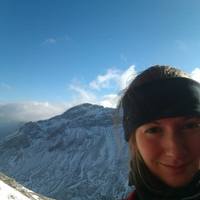
Dr. Gina Moseley (University of Innsbruck, Austria), speleologist, palaeoclimatologist, and leader of the Northeast Greenland Caves Project, is aiming to take an expedition of 5 people to the far northeast of Greenland within the Arctic Circle during the summer of 2015. The main purpose of the expedition will be to visit caves and collect samples of calcite and sediment deposits that were deposited during a time when the climate was warmer and wetter than it is today. The chemical signature of the samples will later be analysed in order to construct a record of temperature, moisture, and vegetation change during the past.
“We have a fantastic opportunity here to improve our knowledge of long-term climate change in the Arctic, and in particular for a period that was warmer than today. Besides improving our knowledge of past climate, these results are highly important to scientists that work on predicting what our environment might look like in future warmer years.” - Gina
In addition to the sampling work, Gina’s team, which includes decorated polar explorer Clive Johnson (Polar Medal 2001) and National Geographic photographer Robbie Shone, will be searching this little explored area of the planet for previously undiscovered caves. The expedition has already received support from Ranulph Fiennes Transglobe Expedition Trust, the Petzl Foundation, the British Cave Research Association, the National Speleological Society, and the Ghar Parau Foundation.
Ranulph Fiennes said …
"The Transglobe Expedition Trust is delighted to be supporting the Northeast Greenland Caves Project which the trustees believe perfectly combines valuable contemporary research with the traditions of polar exploration. We wish the team members every success in this highly ambitious expedition."
The Project launched a crowdfunding campaign on Monday 3rd November using the crowdfunding platform crowdfunder.co.uk (http://www.crowdfunder.co.uk/northeast-greenland-caves-project/) in order to raise the remaining funds needed to collect the samples. During the first 24 hours they were successful in reaching 10% of their target. The funds will cover the cost of transport, logistics, equipment, and supplies for the expedition. The crowdfunding campaign is structured so that it runs until 29th December, and there is a huge variety in the level of rewards for both individuals and businesses. As with most crowdfunding campaigns, if the full £67,000 target is not met, then the project doesn’t receive any money at all, so if the public like the idea, it is really important for them to support it.
If you would like to support this project, please visit the campaign site and make a pledge, and/or share, tweet and tell as many friends, family and colleagues as possible.
We can be found via several social media outlets including:
www.northeastgreenlandcavesproject.com
https://www.facebook.com/NortheastGreenlandCavesProject
http://instagram.com/negreenland_caves
https://twitter.com/Greenland_Caves