Stephen A Daire
John Hopkins University, Whiting School of Engineering, Graduate Student
- Rutgers, The State University of New Jersey, Anthropology, AlumnusUniversity of Southern California, Spatial Sciences Institute, Graduate Studentadd
- Cultural Studies, Gender, Culture, Religion, New Media, Paleobotany; Paleontology; Paleoecology, and 98 moreClassical rhetoric, Philosophy of Mind, Evolutionary Biology, Human Evolution, Psychology, Socio-Linguistics, Socio-Economic Impact of Rural-Urban Migration, Underwater Archaeology, Use Wear Analysis, Nautical Archaeology, Osteoarchaeology, Palaeoanthropology, Evolution and Human Behavior, Quaternary Geology, Palaeogeography, Paleoenvironment, Submerged Prehistoric Archaeology, Palaeolithic Archaeology, Mediterranean Underwater Archaeology, Commercial/ Contract Archaeology, Geochronology, Mesolithic Archaeology, Anthropology, Evolutionary Ecology, Holocene sea level change, Mediterranean prehistory, Saruq Al-Hadid, Mesopotamian Religions, Human behavior, biogeography, Late Pleistocene, Human Behavioural Ecology, Arqueología, Prehistoria, Método Arqueológico, History, The peopling of the Americas, Speleology, Vertebrate Paleontology of Xenarthra, Human osteology, Paleopathology, Vertebrate paleontology, Marine Biology, Cave Biology, Remipedia, Underwater Prehistoric Archaeology, Vertebrate Paleontology, Paleoanthropology, Education, Social Sciences, Human Sacrifice, Antropología Física, Forensic Archaeology, Physical Anthropology, Forensic Anthropology, Bioarchaeology, Archaeology, Mortuary archaeology, Ancient Warfare, Bronze Age Europe (Archaeology), Late Bronze Age archaeology, Stable Isotopes, Zooarchaeology, Stable Isotope Analysis, Engineering, Chemical Engineering, Technology, Ecology, Sociology, Public Health, Economics, Political Science, Philosophy, Civil Engineering, Information Systems, Medicine, Climate Change, Computer Science, Physics, Biology, Chemistry, Architecture, Communication, International Relations, Business, Media Studies, Management, Artificial Intelligence, Human Rights, Public Policy, Geography, Environmental Sustainability, Data Mining, Ethics, Educational Technology, Languages and Linguistics, Mathematics, Research Methodology, Software Engineering, Renewable Energy, International Law, and Sustainable Developmentedit
- Researching Evolutionary Biology, Geographic Information Science &Technology, VR Development, Bioastronautics, and Underwater Speleology.edit
Billions of dollars of economic activity flow through offshore cables every day, carrying internet traffic and phone calls around the globe. The reliability of these high-fixed-investment assets depends on periodic inspection, as well as... more
Billions of dollars of economic activity flow through offshore cables every day, carrying internet traffic and phone calls around the globe. The reliability of these high-fixed-investment assets depends on periodic inspection, as well as rapid-response troubleshooting. Offshore cable inspection is expensive due to the remote locations, harsh environments, and high capital cost of equipment. This cost eats into the profitability of operating such a cable.
The system proposed in this document aims to reduce the cost-per-mile of undersea cable inspections, which would improve the economics of deploying undersea cables, enabling faster and more robust communications to reach underserved areas around the globe. In addition, reducing the cost of inspection would allow for more frequent inspection of existing cables, resulting in higher reliability and a longer lifespan.
Technological advancement in high-fidelity sensors, signal processing, and sensor fusion through AI (Artificial Intelligence) provide an opportunity to elevate the intelligence gained from an inspection. In addition, advancements in battery technology, navigation, and robotics provide an opportunity to expand the inspection capacity of a single ship and crew by deploying multiple independent vehicles.
The system proposed in this document aims to leverage these opportunities to the benefit of stakeholders including cable operators, inspection contractors, terrestrial network operators who are the direct customers of the cable traffic, and the end user who is the end customer of the network traffic. As much as practical, the system leverages existing deployed capital equipment to ease adoption in the commercial market for inspection equipment.
Research Interests:

Space systems are vital to sustainability, strategic stability, economic growth, scientific discovery, and the betterment of the human condition. Decision-makers would benefit enormously from a sustained and focused multidisciplinary... more
Space systems are vital to sustainability, strategic stability, economic growth, scientific discovery, and the betterment of the human condition. Decision-makers would benefit enormously from a sustained and focused multidisciplinary examination of the current state-of-affairs in space law and policy, and the ways and means for civil society to mold the future of space utilization. While the body of international space law and practice instruments have been established and serve as a road map for national security, civil, and commercial space activities, work still needs to be done at the national level to give effect to the implementation of obligations under the United Nations space treaties. In particular, the private sector needs a global framework that is transparent, uniform, simple, and predictable. This can only be achieved through a bottom-up approach that relies on the advice and experience of civil society. The rule of law in space must be firmly established with alacrity for the next generation of space adventurers to succeed. Countries and companies transitioning towards the new global space economy will need an unbiased and thoughtful institution that looks at the totality of the challenges ahead.
Research Interests:
Research Interests:
Review the RFP - N65236-03-R-0320 and prepare a proposal outline.
Research Interests:

As we have been hunkering down for the past month, now going on two critical reflection is required on the long-term impacts of COVID-19. Taking comparisons from recent discoveries of HIV/AIDs linage within non-human primates and humans... more
As we have been hunkering down for the past month, now going on two critical reflection is required on the long-term impacts of COVID-19. Taking comparisons from recent discoveries of HIV/AIDs linage within non-human primates and humans we can glean in sightings into COVID019s evolutionary trajectory. This hints to the viral habituation of HIV/AIDS within humanity that we are likely to discover as a parallel with COVID-19. HIV seems to have been infection chimps for thousands of years (https://www.sciencedaily.com/releases/2010/09/100916145059.htm). With long-term interactions between humans and pathogenic agents (HIS/AIDS/Cholera/etc.)
Research Interests:
• Trimble Juno 3B GPS Unit • Kayak • Scuba gear • Dive computer • Water depth measurement tape Methodology Data Collection • Coordinate system: GCS WGS 1984 • Kayak-GPS data (TerraSync) • Swimmer-depth(m)/ temperature(℃), condition,... more
• Trimble Juno 3B GPS Unit • Kayak • Scuba gear • Dive computer • Water depth measurement tape Methodology Data Collection • Coordinate system: GCS WGS 1984 • Kayak-GPS data (TerraSync) • Swimmer-depth(m)/ temperature(℃), condition, substrate • Points = individual organisms • Lines = length > 5m, width < 5m • Polygons = >5m2 Hypothesis W e are evaluating GPS as an efficient tool in measuring kelp distribution based on sea temperature and depth. We expect kelp to be moving into colder and deeper waters. We also expect to see invasive species encroaching on kelp habitat. RESULTS Introduction T he Washington Department of Natural Resources standardized kelp forest mapping in its Nearshore Habitat. The Mayne Island Conservancy in British Colombia built upon this methodology by setting collection criteria based on kelp density. We are studying to see if this is an efficient model to follow.
Research Interests:
Karst Regional Mapping on Earth provides an analogous testing model for remote sensing (RS) comparison to other planetary bodies. On Earth, karst regions present an underrepresented area of scientific exploration that provides new... more
Karst Regional Mapping on Earth provides an analogous testing model for remote sensing (RS) comparison to other planetary bodies. On Earth, karst regions present an underrepresented area of scientific exploration that provides new insights into numerous fields of study. Caves possess a host of data sources (e. g. paleoenvironmental, biological, stratigraphic, etc.) and are critical in the hydrological and sedimentary rock systems. On Mars, possible karst regions will present themselves on several terms, and will provide ample amounts of data on the formation of the planet, our solar system, and other scientific fields. This map focuses on the possible karstic bearing features in the approximately 10,000 km2 area of the Noctis Labyrinthus (Centered at 9° South, 95° West) as well as possible geohazards to US survey in the region (Table 1 and Image 1.). These areas are of key interest for planned exploration of the planet due to their hydrogeological processes, exo-geologic feature age, and chemical analysis for disequilibrium of anoxic environments for biogenic gases.
Research Interests:
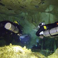
This work outlines an underwater laser scanner (ULS) operational readiness test (ORT) demonstrating the efficacy of ULS-200 in response to National Aeronautics and Space Administration (NASA) Planetary Science and Technology through... more
This work outlines an underwater laser scanner (ULS) operational readiness test (ORT) demonstrating the efficacy of ULS-200 in response to National Aeronautics and Space Administration (NASA) Planetary Science and Technology through Analog Research (PSTAR) Program knowledge gaps. This geographic information science and technology (GIST) project advises stakeholders on extravehicular activity (EVA) design and engineering (D&E) via cave diving. Analog surveys define strengths, weaknesses, opportunities, risks, and threats (SWORT) in three-dimensional (3D) remote sensing (RS) detection and ranging (DAR) via light (LiDAR) and photogrammetry (PhoDAR). Sidemount cave diving procedures and life-support systems (LSS) facilitate paleontological, hydrogeological, and microbiological evidence sampling, mitigating crew resource management (CRM) risks. 3D geographic information systems (GIS) toolkits produce LiDAR and PhoDAR digital terrain models (DTM) that require British Cave Research Associa...
Research Interests: Paleoanthropology, Geophysics, Quantum Physics, Remote Sensing, Quantum Optics, and 15 moreCultural Heritage, Paleoclimatology, Operations Management, Systems Engineering, Human Factors, Natural Resource Management, Survey Research, Underwater Archaeology, Speleology, Life Support Systems, Masters thesis, Geohydrology, ProQuest, Applied Optics, and Aeronautics and Astronautics
Research Interests:
This study identifies the skill requirements for geographic information system (GIS) positions, including GIS analysts, programmers/developers/engineers, specialists, and technicians, through a content analysis of 946 GIS job... more
This study identifies the skill requirements for geographic information system (GIS) positions, including GIS analysts, programmers/developers/engineers, specialists, and technicians, through a content analysis of 946 GIS job advertisements from 2007–2014. The results indicated that GIS job applicants need to possess high levels of GIS analysis and modeling skills (e.g., database development) and personal and social skills (e.g., communication) to obtain employment, although specific skill requirements differed significantly depending on job title. The findings from this study may be useful for improving GIS majors’ employability.
Research Interests:
Research Interests:
Research Interests:
Research Interests:
As we have been hunkering down for the past month, now going on two critical reflection is required on the long-term impacts of COVID-19. Taking comparisons from recent discoveries of HIV/AIDs linage within non-human primates and humans... more
As we have been hunkering down for the past month, now going on two critical reflection is required on the long-term impacts of COVID-19. Taking comparisons from recent discoveries of HIV/AIDs linage within non-human primates and humans we can glean in sightings into COVID019s evolutionary trajectory. This hints to the viral habituation of HIV/AIDS within humanity that we are likely to discover as a parallel with COVID-19. HIV seems to have been infection chimps for thousands of years (https://www.sciencedaily.com/releases/2010/09/100916145059.htm). With long-term interactions between humans and pathogenic agents (HIS/AIDS/Cholera/etc.)
Research Interests:
Professional ethics are a longstanding tradition in numerous trade settings (Religion, Law, Medicine, Business, Military, Engineering) to protect professionals and consumers from unscrupulous individual and group actions. Membership in a... more
Professional ethics are a longstanding tradition in numerous trade settings (Religion, Law, Medicine, Business, Military, Engineering) to protect professionals and consumers from unscrupulous individual and group actions. Membership in a trade is stipulated as an individual acknowledgement of possession of specialized knowledge, tool, and skill sets developed and utilized as a means of living. Membership requires adherence to specific accordant bylaws, and codes of ethics (CE) to promote public and peer trust. Rationale for CE stem from professional case studies of social and legal commitments with regards to geospatial applications, services, and data.
Research Interests: Engineering, Computer Science, Ethics, Remote Sensing, Human Rights, and 15 moreMathematics Education, Privacy, Medical Education, Remote sensing and GIS applications in Landscape Research, Remote sensing and GIS, Medicine, International Law and Human Rights, Code of Conduct, Privacy and data protection, GIST, Codes of Ethics, Codes of Professional Ethics, Computer Science and Engineering, GIST Code of Conduct, and GIST Body of Knowledge
The Vancouver Fraser Port Authority, or Port Metro Vancouver (PMV), is contending with being a prosperous and active port while mitigating and resolving key anthropogenic threats to listed whale populations from species at risk... more
The Vancouver Fraser Port Authority, or Port Metro Vancouver (PMV), is contending with being a prosperous and active port while mitigating and resolving key anthropogenic threats to listed whale populations from species at risk assessments (SARA). They are addressing issues in terms of quantifiable reductions in shipping traffic noise, ship strike, and environmental contamination effects on Cetacean species to meet their definition of sustainability. The PVM spearhead Enhancing Cetacean Habitat and Observation (ECHO) program definition of sustainability is a sustainable port delivers economic prosperity through trade, maintains a healthy environment, and enables thriving communities through collective accountability, meaningful dialogue and shared aspirations. Its program structure is aiding it as it is taking a leadership role in contending with predicted regional shipping activity increases by collecting datasets proactively to protect the species and to promote the ports success. They are utilizing a collaborative research and management coordination strategy for federal-academic-private consultation for networking, study, and response.
Research Interests: Environmental Engineering, Ocean Engineering, International Relations, International Business, Virtual Reality (Computer Graphics), and 10 moreInternational Law, Autonomous Robotics, Environmental Sustainability, Artificial Neural Networks, Costal Oceanography, Virtual Learning, Side Scan Sonar for Survey, SONAR Systems and Underwater Signal Processing, Orcinus Orca, and Geographic Information Systems (GIS)
Deceit and Self-deception are both pervasive in nature as physical and behavioural mechanisms. They allow organisms, and groups of them, to gain an advantage over other organisms for their own benefit through deception. Or, they cause one... more
Deceit and Self-deception are both pervasive in nature as physical and behavioural mechanisms. They allow organisms, and groups of them, to gain an advantage over other organisms for their own benefit through deception. Or, they cause one organism to change their perception of benefits through internal self-deception, or biased memory formation. Both forms of deception are active in socio-political issues, and through observations on nuclear proliferation we can begin to see patterns that arise from their use and discovery. Nuclear proliferation and its consequences are a direct threat to the survival of many species. It allows reflection on deception in and between humans and in nature, and is a crucial field of study. Applying a method of solving fair division problems would most likely allow for nations commitment to proliferation, and concurrently their active deception to be discerned in greater detail. The Atomic Spies of the 1940s, to Rickover's Folly of the 1950s, and currently North Korean nuclear proliferation and targeted killings programs confirm deception plays one of the most critical roles in the investment and management of nuclear research, materials, and militarization. The Method of Markers is a procedure to affirm fair division of continuous or discontinuous goods between multiple stakeholders. It assumes each individual (N) makes their bid anonymously, that each player will value each good differently, and that they will be removed from bidding once they placed all their bids S=(N-1). It allows for linear modeling of the
Research Interests:
Population estimation, remote sensing (RS), and geographic information systems (GIS) represent a research confluence of evolutionary biology, traditional census data collection, and technological innovation. Population growth, predictive... more
Population estimation, remote sensing (RS), and geographic information systems (GIS) represent a research confluence of evolutionary biology, traditional census data collection, and technological innovation. Population growth, predictive evolution, anthropogenic impact, climate response, and natural resource economic models are derived from accurate global population estimates. Population estimates connote spatial distribution of local, regional, and global resources for assessment and planning. RS methods developed for this application domain include: volumetric, 3D reconstruction, optimal scale fractal, and other analyses. Each has different application considerations dependent upon the geospatial scale, number of observation perspectives utilized, and environmental context of the estimation. Two foci have developed within GIS & RS, Geographic Information Science and Technology (GIST), for population estimation. These foci have developed in response to scale and resolution calibrations dependent on environmental sensing context. These considerations stem from estimation of urban and remote populations and are harmonizing via several research areas. Concerns on the cost and accuracy of census reporting add to the discussion of improvements on methods for temporal-spatial analysis cost reduction and faster results. Rapid urbanization and projected population growth will affect tens of millions of people in terms of housing, occupation, and environments for permanent, squatting, and transient occupants globally. In contrast, substantial portions of the world are remotely offset from urbanized populations and require GIST population estimation for global census estimates.
Research Interests:
Cave diving and karst research have evolved in form and function throughout the 1900s through trial and error learning in field survey procedures, tools, and techniques. In Mexico the Spanish form of the Maya word for surface opening with... more
Cave diving and karst research have evolved in form and function throughout the 1900s through trial and error learning in field survey procedures, tools, and techniques. In Mexico the Spanish form of the Maya word for surface opening with access to groundwater d'zonot (cenotes) are the objects of interest in ongoing karst studies of the region with current information produced at pace via field survey, cave diving, remote sensing (RS), and unmanned systems (US). Development of RS systems, and the subsequent datasets collected from their deployment, are becoming pervasive in multidisciplinary research and planning due to their capacity to reduce survey expenses and time. Need for integration of satellite, manned, and US-RS datasets for structural analysis of Yucatan Karst Region to assess for anthropogenic impacts and geohazards is pressing due to climate change in terms of conservation planning and economic impacts. Background:
Rochon et al. (2010) reviews advances in disease ecology research via applications for GIST mapping and modeling software for public health and emergency response and management (PHERM) applications in developing countries. They detail... more
Rochon et al. (2010) reviews advances in disease ecology research via applications for GIST mapping and modeling software for public health and emergency response and management (PHERM) applications in developing countries. They detail the use of GPS, GLONASS, Galileo, Beidou, SpatioTemporal Epidemiological Modeler, the Hydrologic Engineering River Analysis System, Integrated Emergency Management Information System (IEMIS) and HAZUS-MH (multi-hazard), and numerous systems. The authors’ place an
Research Interests: Evolutionary Biology, Epidemiology, Infectious disease epidemiology, Remote Sensing, Public Health Policy, and 5 morePublic Health, Remote sensing and GIS applications in Landscape Research, Human Evolutionary Biology, Medical Anthropology, Global Health and Health policy, Evolutionary medicine, and Geographic Information Systems (GIS)
Myint et al. (2011) argue objects-based classifiers are significantly better than the traditional per-pixel classification schemes. Tradition per-pixel schemes inhibit remote sensing analysis of urban land cover types in high resolution... more
Myint et al. (2011) argue objects-based classifiers are significantly better than the traditional per-pixel classification schemes. Tradition per-pixel schemes inhibit remote sensing analysis of urban land cover types in high resolution spatial data due to the utilization of spectral classes, to the neglect of spatial information. The object-based scheme promotes classification segmentation via fractal net evolution approach (FNEA) for boundary generation at various scales based on the Mandelbrot set compactness factor. Their work focus on urbanized Phoenix, Arizona as the area of interest (AOI) to test object-based classification for accuracy comparisons to per-pixel classification schemes.
Research Interests:
"Ground truth” is an inappropriate terminology for data collection classification in remote sensing (RS) and survey for several reasons. Analysis and assessment of remotely sensed datasets are reviewed against field survey data (ground... more
"Ground truth” is an inappropriate terminology for data collection classification in remote sensing (RS) and survey for several reasons. Analysis and assessment of remotely sensed datasets are reviewed against field survey data (ground truth). Sensor type, noise, decoherence, spatial and time lag on collection and processing all interact upon precision and accuracy assessments for remotely sensed datasets. RS quality control and assurance (QCA) has a minimum of approximately 80% classification accuracy per individual class, and comprehensive understanding of the remaining 20% of uncertainty for use in research, planning, response, and decision-making against field survey data.
Research Interests:
The maximum likely hood classifier will assign pixel x to forest training data. X is more centrally located within the forest distribution out of the two sets of the overlapping probability density functions.
Research Interests:
The pace and scale of anthropogenic alterations of the Earth’s surface within the past ≈68-73 years are unprecedented in the fossil record and are only comparable to the oxygenation of Earth by phototrophs in magnitude. The United Nations... more
The pace and scale of anthropogenic alterations of the Earth’s surface within the past ≈68-73 years are unprecedented in the fossil record and are only comparable to the oxygenation of Earth by phototrophs in magnitude. The United Nations Sustainable Development Conference on Environment & Development Agenda 21 (1992) highlights key sections with topics of interest to address some of the most pressing contemporary global problems including deforestation, sustainable settlement, water supply quality, and other wicked problems.
Research Interests:
Research Interests:
Research Interests:
Research Interests:
Is comanagement between indigenous and state organizations a viable means to meet the needs of 21st century sustainable development ideals? Can a balance be found between the federal governments and the Native American tribes in the... more
Is comanagement between indigenous and state organizations a viable means to meet the needs of 21st century sustainable development ideals? Can a balance be found between the
federal governments and the Native American tribes in the comanagement of natural resources? Is it possible to restore cultural heritage of the Native Americans along the way, are they willing to participate (McGregor, 2004; Wyatt, 2008)? What differences and similarities can be denuded cross jurisdictional analyses of indigenous and state interactions towards comanagement strategies? What are the inherent sociocultural
obstacles and how are they overcome? Finally, after sociocultural barriers have been defined, can traditional knowledge be effectively and respectfully incorporated in aboriginal forestry practices, particularly in the Yellowstone to
Yukon Region (Y2Y)? Would this allow for a paradigm shift to occur to undermine centuries of colonialism by promoting methods for indigenous dissemination of knowledge (McGregor,
2004; Wyatt, 2008)?
Research Interests:
Research Interests:
Self-medication observed in Primatomorpha is diverse, embedded, and crucial in comprehending evolution of the Genus Homo. It has potential to inform phenotypic patterns, genetic imprinting, and ecological coevolution in Hominidae through... more
Self-medication observed in Primatomorpha is diverse, embedded, and crucial in comprehending evolution of the Genus Homo. It has potential to inform phenotypic patterns, genetic imprinting, and ecological coevolution in Hominidae through diet and pharma/phytoceuticals. Preliminary studies confirmed its benefits, ease of incorporation into behavioral suites, robusticity as an adaptive complex, and potential utilization in public health strategy. Determining what varieties of primate behaviour combat generalized infections and how effective they are informs ongoing research and policy. Consumption of Vernonia amygdalina at 50 grams per day is a cost effective, indirect method of epidemic control (eg. HIV/AIDs). Additionally, V. amygdalina will prove to be a beneficial preventative medicine for cancer, infection, and malnutrition in humans suffering from the ills of urbanization and the ecology of poverty (Stillwagon, E.) . Its cultivation and production could come to represent an interdisciplinary tool to inform models in evolutionary biology, procedure in primate conservation, and strategy in public health.
Research Interests:
Zoopharmacognosy is a behavioural complex present in both non-human, and humans. It is comprised of elements & methods in which animals self-medicate by selecting, ingesting, or topically applying plants, soils, insects, or psychoactive... more
Zoopharmacognosy is a behavioural complex present in both non-human, and humans. It is comprised of elements & methods in which animals self-medicate by selecting, ingesting, or topically applying plants, soils, insects, or psychoactive compounds to alleviate & treat ailments. “Humans use two of the plants as intestinal antiparasitic agents in traditional medicine and include numerous other plants in the diet,” as chimpanzees says Nègre. This is a socially active & individually developed behaviour in the wild & captivity, it is also easily transmissible as has been witnessed in captive artificially inseminated neonate studies (Nègre et al., 2004; Huffman & Hirata, 2004). Initial laboratory tests & field observation over the past forty years have revealed interesting results that seem to point to modes of secondary inheritance, spontaneous behaviour generation, & selective novel foraging as this behavioural complexes means of transmission & application. Of the two methods of zoopharmacognosis in primates I will focus on the ingestion of whole folded hispid(hairy) leaves without chewing occurs repeatedly, synchronizing with the rainy season as it correlates to increases in Oesophagostomum stephanostomum infection, & Nematodes, & Cestode proglotids prevalence in fecal samples(Huffman & Hirata, 2004; Whiten, 2005; Jazen et al., 1978, Wrangham et al. 1995). This work will review self-medicating as a critical behaviour in all hominidae, as it forms a unique perspective into the evolution of diet, health, & sociality in our species & non-hominidae relatives. Bitter pith chewing will then be noted as, the acquisition of steroidal glycosides, a crucial zoopharmacognosy skill. It is key to understanding the therapeutic qualities of these components in selective foraging diets due to its direct pharmacokinetics (Nègre et al., 2004). The perspective afforded to us by this behaviour still lacks a point of origin, with most wild species already deeply rooted in the behaviour, and will therefore only obfusticate its definition, yet genetic insight may afford a partial understanding of its roots. Studying these skills, or the lack thereof, allows use of a unique perspective into the evolutionary effects of diet & ecological interactions of these species, and others outside of Hominidae. They could have therapeutic potential in understanding the coevoltuion of antigen mechanisms in parasitism & the genetic underpinnings of dietary medication.
Research Interests:
“HIV appears to be evolving into less deadly, less infectious form[s],” says Science Alerts news article from the 3rd of December, 2014. In recent proceedings of the National Academy of science of the United States of America, several... more
“HIV appears to be evolving into less deadly, less infectious form[s],” says Science Alerts news article from the 3rd of December, 2014. In recent proceedings of the National Academy of science of the United States of America, several research papers from Oxford & Emory Universities, and many news articles in the BBC & ScienceAlert word is spreading like wildfire of the evolution of the human immunodeficiency virus(HIV). This logical progression of a disease from a more virulent form to a more & more benign form has been in several case studies, such as the The U.S. Tennessee Valley Authority (TVA) - The Integration of Malaria Control with Economic Development (1933), the 1990s South American cholera outbreaks, and several other studies.
Research Interests:
The Northern Virginia Regional Commission (NVRC), the Port of LA, Division of Facilities Management at the University of Colorado at Boulder, and the Chesapeake Energy projects presented in the research reports were well suited to their... more
The Northern Virginia Regional Commission (NVRC), the Port of LA, Division of Facilities Management at the University of Colorado at Boulder, and the Chesapeake Energy projects presented in the research reports were well suited to their organizational contexts. They all perceived and responded to goals and obstacles on varying degrees and scales in terms of management strategies, costs, and perceived benefits of GIS implementation.
Solar energy potential, port public safety, and network uptime mapping potential benefits were understood prior to their implementation, and guided goal formation. Potential benefits included promoting public increases in solar installation, reductions in redundancy of datasets, and reductions in cost of troubleshooting and loss of service, to name a few,
Utility infrastructure management benefits were less clear from conception, and are being derived as use of the system is developing (e. g. placement of construction equipment on a tunnel that was not meant to bear that weight). (Brunsvold, C. 2017; Casillas, S. 2017; Delgado, J. 2017; Lee, T. 2017)
Research Interests:
The nation of Uruguay poses on of the most prolific collection of Age of Exploration shipwrecks in new world archaeology. The concentration, density, and diversity of wrecks is due to the nations location as South America’s, most Southern... more
The nation of Uruguay poses on of the most prolific collection of Age of Exploration shipwrecks in new world archaeology. The concentration, density, and diversity of wrecks is due to the nations location as South America’s, most Southern port city. With such a critically positioned port, and due to the rich maritime heritage, there is a pressing need for protection and conservation of these multinational cultural materials. This need precipitated into the development, collection, and production an incipient Underwater Cultural Heritage (UCH) database for the country of Uruguay. To complete the production of this database, certain goals and elements are being met and are mission critical for success.
Research Interests:
In a review of Canadian historic and natural resource legislation and endeavors of both indigenous and nonindigenous groups, there are clearly defined patterns of behaviour in identification, classification, organization, and preservation... more
In a review of Canadian historic and natural resource legislation and endeavors of both indigenous and nonindigenous groups, there are clearly defined patterns of behaviour in identification, classification, organization, and preservation which can be perceived through their frameworks. Both natural and historic preservation can be considered tangible and intangible ethnopsychological facets to many tribes and directly affect their cultural welfare. This is due to a continuing heritage of the spiritual amalgamation of the nature and supernatural through observances via Traditional Knowledge and geographical embeddedness. The effectiveness and scope of preservation efforts are displayed and observed in the context of the UNESCO (United Nations Educational, Scientific, and Cultural Organization) WHC (World Heritage Conventions) operational guidelines that were set forth in the 1972 ratification. Through this, we can see the continuing imbalances of social structure due colonization and its divisive legacy. By signing and sanctioning this ratification, Canada acknowledged and agreed to meet these needs for CRM (Cultural Resource Management) set forth by the standards of UNESCO WHC. Using the Ktunaxa First Nation, particularly the Lower Kootenay Band, as a window into these issues we can see how current legal action and archaeological studies have affected the nation, decolonization, and CRM.
Research Interests:
A paper on social agency in Latin America.
Research Interests:

August: Workforce/Industrial Base Join us in talking about and answering these questions: How does this help make us a multiplanetary society? How does this help us now? Why should the public care? The Foundation For The... more
August: Workforce/Industrial Base
Join us in talking about and answering these questions:
How does this help make us a multiplanetary society?
How does this help us now?
Why should the public care?
The Foundation For The Future’s Conversations for the Future conference series is designed to broaden the knowledge base among key officials and stakeholders through a wide range of educational activities.
Tuesday August 8, 2023:
***Join us EARLY on the Zoom for a short “Meet & Greet” with the speakers and hosts at 9:50am***
Host & Moderator: Rebecca Schembri, Foundation for the Future
10am EST: Stephen A Daire, Owner, Protean Industries
1030am EST: Quentin Donnellan w/ Hypergiant
11am EST: Coffee on the Moon w/ Inara Tabir - and Guest Mike Simmons
Founder, Astronomy for Equity
Research Interests:
Team Project: Autonomous Underwater Vehicle (AUV) Prototype Management of Systems Projects Objectives By completing this assignment, you demonstrate that you are able to: 1. Create core project management artifacts by applying the... more
Team Project: Autonomous Underwater Vehicle
(AUV) Prototype
Management of Systems Projects
Objectives
By completing this assignment, you demonstrate that you are able to:
1. Create core project management artifacts by applying the primary project
management “tools” presented during this course (WBS, SOW, CPM Network,
Schedule, Cost Estimate).
2. Develop a proposal.
3. Organize and manage a team by applying communication and interaction
skills.
4. Present complex information to a customer in a limited period of time.
Background
Recent political pressure has resulted in the need to terminate the use of dolphins
to support warfare applications. Senior Navy leadership has directed that
alternatives be explored over the next 12 to 18 months. Agreements have been
reached to phase out the use of dolphins over the next 3 years.
Phase I: This schedule will require a concept demonstration to be completed
within 18 months or less, preferably within 12 months. The concept demonstration
will include a fully operational prototype. A goal is for the prototype to be
production representative.
Phase II: After a successful demonstration, the remaining period of time will be
used to finalize the design, transition to low-rate initial production (LRIP) and finally
full-rate production (FRP).
Based upon your company’s performance during the first year of UAV-related work
under your existing contract, SPAWAR leadership has come to you for a sole source
contract to provide an alternative to the use of dolphins (Phase I). Sole source
contracting was determined to be an effective acquisition strategy to reduce the
acquisition cycle time. The contract will specify the development of a shallow
water or littoral Autonomous Underwater Vehicle (AUV) prototype, primarily for
surveillance and reconnaissance with limited manipulative abilities consistent with
the abilities of dolphins, primarily limited to attaching recovery lines to various
645_667-M16-A1A
Version 005A
7 July 2022
2
objects. These capabilities have been previously demonstrated individually but not
in an integrated fashion. The primary objective is to identify underwater mines and
other subsurface weapons but it is also intended to assist with recovery of reusable
targets, test torpedoes, etc. The demonstration tests are to be included in the
prototype phase of the project.
Although not specifically addressed during discussions with SPAWAR, it appears
that there is potential for a follow-on contract to include an option for final
engineering and manufacturing development (EMD) and production (Phase II), all
capabilities readily available within your company. SPAWAR did not indicate
whether you were the only contractor contacted about this opportunity. You have
decided to provide a detailed proposal for Phase I, and a summary proposal for
Phase II.
Pricing of the prototype phase may be critical to future work in this area and the
production of such a system is seen as lucrative future business for the company
and an appropriate application of core capabilities.
The underwater vehicle must be able to operate in shallow water ranging from a
few feet to approximately 200 feet of depth. Threshold mission endurance has not
been defined but based upon operational requirements; the vehicle must have a
minimum range of 5 miles (radius). Size and weight have not been specified but
the system could be fielded within a limited time (12-18 months) if the current
dolphin support equipment could be utilized. Currently, an individual dolphin is
transported by a large rigid inflatable boat (RIB) and is handled by two specially
trained personnel. One of the many technical challenges will be the development
of a system to relay data to/from the vehicle for command and control, as well as
navigation.
References
5. All Course Modules
6. Course Text
7. Homework Assignment Feedback
8. Exam Feedback
645_667-M16-A1A
Version 005A
7 July 2022
3
Assignment
Your team is to develop a proposal based upon the limited amount of information
that has been provided by SPAWAR. Additional details regarding AUVs may be
found by performing Internet research.
At a minimum, the following items must be in the proposal:
Statement of Work (SOW)
Concept of Operations (CONOPS)
Work Breakdown Structure (WBS)
Top Level Specification
Critical Path Method (CPM) Network
Schedule
Cost Estimate (demonstration phase and optional EMD/production phases)
The Phase I proposal shall be detailed*. The Phase II proposal should be at a
summary level. Phase I/II artifacts can be combined if Phase II elements are clearly
identified and can be easily separated out by the customer.
Your team will also develop a complimentary presentation to be presented via
Zoom or Teams to the customer. The presentation should “sell” your company and
provide a summary of the artifacts included in the proposal.
NOTE: The intent of this assignment is to focus on project planning and control
functions. Thus, the effort should be primarily directed at the SOW, WBS, CPM,
schedule, and cost estimate elements of the proposal. The CONOPS and
specification and do not need to be overly detailed. The cost estimate should be
consistent with the recommended contract type and should support a budget-level
estimate.
* The proposal shall include the artifacts as listed. It is strongly recommended that
additional information is provided to produce a cohesive, integrated product
(example: Proposal Overview, Table of Contents). The proposal should be a single
document (PDF is acceptable) and organized in the order you expect it to be read.
645_667-M16-A1A
Version 005A
7 July 2022
4
Overarching Guidelines
Be free and creative in developing your team project concept. Remember: your
proposed solution doesn’t have to work! Focus on the project management (vs.
systems engineering) aspects of this project. However, every element of your
concept must be adequately documented in your proposal.
Each team shall upload a final version of their materials to Canvas.
The time allotted for each presentation is 30 minutes. Presentations will be cut
off at 40 minutes.
Teams will present via Zoom or Teams. For online students, date/time slots will
be provided by your Section Instructor. For in-class students, presentations will
be scheduled for the last day of class.
If one of your team members cannot be available for the presentation, we
recommend incorporating a video of him/her into the presentation. For in-class
students, the team member can be brought in via conference call (a conference
call does need some advance planning). We highly recommend that each team
member presents a portion of the proposal. At a minimum, each member must
have a specific role during the presentation.
Team Presentation Information & Suggestions
Carefully consider the audience you will be addressing and what they may want
or expect to hear; prepare your brief to match the interest and needs of the
audience.
Draft the brief and present it to the team for critique. When it is smooth,
rehearse it to fit the time allotted
These assignments intend for you to PLAY THE ROLE of Project Manager and
give the briefing as though you were in the appropriate setting, not in the
classroom. Consider this situation when selecting your attire and the formality
of the hard copies you give your instructors.
Identify your team and the presenter(s) for the assignment. If more than one
team member presents (preferred), plan for a smooth handoff that fits the
scenario.
If one of your team members cannot be at class for the presentation, you may
incorporate a video of him/her into the presentation, or the team member can
be brought in via conference call (a conference call does need some advance
planning).
Identify the assignment, audience and/or the issue(s) being addressed.
645_667-M16-A1A
Version 005A
7 July 2022
5
Make your message have interest (ask yourself - so what?).
Consider the timeframe of the presentation with respect to the project
schedule.
Make the presentation compatible and complementary with the other
assignments performed during this course.
Use props to add interest - show enthusiasm and creativity.
Pay attention to delivery – poise, style, ...
Make illustrations communicate – pay attention to content, organization, layout,
design, technical accuracy, number of slides, ...
Use your time effectively – questions about the brief will not be held until you
have completed the presentation... count on the instructors to ask questions!
Research Interests:
Research Interests: Planetary Science, Remote sensing and GIS applications in Landscape Research, Archaeology of Caves and Caverns (Archaeospeleology), Underwater Archaeology, Geoarchaeology and Paleoenvironmental Reconstructions, and 4 moreAeronautics and Astronautics, Geographic Information Systems (GIS), Underwater speleology, and analog astronautics
Slide 1 Bio: Hello everyone, my name is Stephen, as a brief on my background I am an Eagle Scout Association Lifetime Member, Vigil Honor of the Order of the Arrow, Explorer’s Club Member – Fellowship Applicant, instructor with the... more
Slide 1
Bio:
Hello everyone, my name is Stephen, as a brief on my background
I am an Eagle Scout Association Lifetime Member, Vigil Honor of the Order of the Arrow, Explorer’s Club Member – Fellowship Applicant, instructor with the International Institute of Astronautic Studies (IIAS), lifetime member of the Association of Spaceflight Professionals, & a research cave diver.
International fieldwork from 2014 - 2018 primed me to needs, potentials, limitations, and externalities in systems engineering, contingency planning, emergency response, spatial cognition, crew resource management, life support systems operations, & technical reporting in surveying, geoarchaeology, and remote sensing.
In 2014, a 3-month University of Montana Yellowstone-to-Yukon research trek & Rutgers University Scuba courses catalyzed my geophysics, hyperbaric medicine, & underwater archaeology interests.
In 2015, I completed an Evolutionary Medicine graduate certificate and a Bachelor of Science in Evolutionary Anthropology with Rutgers focusing on Zoopharmacognosy (zoological self-medication via diet), lithic maritime activity, and environmental-genetic coevolution.
My Geographic Information Science & Technology (GIST) experiences began in the Rutgers Paleoenvironmental Research Laboratory as a graduate research assistant focusing on the Turkana Basin and human evolution over 2 million year ago.
Countless hours in training dives along with >200 submerged hours in various underwater overhead environments with Rutgers, Nautical Archaeology Society, American Academy of Underwater Sciences, National Geographic Society projects, PADI Divemaster Candidacy, and personal projects have furnished my skills in survey, rescue, recovery, & excavation operations utilizing dry-suit, nitrox, lasers, photogrammetry, & sidemount lifesupport diving experiences to handle unknow unknows on-the-fly while conducting EVA analog fieldwork minus the EMU.
Ms. Emery Nolasco and I co-founded Protean GIST Solutions in 2018 focusing aquanautic-to-astronautic research on Earth for technological engineering, design, and methods for human exploration and development of space (HEDS).
My research in 3D remote sensing cartography of underwater caves utilizes photogrammetry, laser scanning, digital elevation modeling, crew management synchronicity, and non-linear optics indexing which has translated my University of Southern California Master of Science thesis into planetary science & technology analog research, P-STAR for short into courses, materials, tools, and methods for astronautic fieldwork technologies and applications. These works have lead to production of chapters in the Handbook of Life Support Systems & Extraterrestrial Environments on various topics.
My presentation is EVAs & Cave Diving: The Next Generation of Human Development & Exploration of Space
PSTAR proving grounds for development of short and long-term
1) Mission planning,
2) Crew Resource Management,
3) Remote Sensing & Robotic Technologies
4) Human Factors Dynamics & Ergonomics
5) And applications Developments.
extend from subaquatic-subterranean exploration.
Slide 2
Science has observed:
Most of the known universe has been observed with 13.8 billion years Cosmic Background Radiation but
95% of Earth’s oceans remain unexplored
3) 99% of Earth’s caves remain unexplored
4) 100% of extraplanetary caves remain unexplored
Underwater caves provide unique research datasources & providing grounds to understand our planet through analogies.
One analogy is between halocline (salt-fresh water mixing) & Polar mesospheric clouds (PMCs) dynamics and effects on imaging equipment.
Subaquatic PSTAR is critical to HEDS AST for L2M success for several reasons, much like Sealab -> Skylab did 50 years ago, and as Mars Desert Research Station does now, Cavelab will extend with in the immediate future.
We know too little about our own planet, we need to play catch up on the learning curve with immediate field research.
Slide 3
Global karst aquifers form 3D drainage systems underground as water dissolves minerals & stores in fractures which present cave-in hazards to many parts of the world extending from buoyant capacities, rain fall fluctuations, and changing sea-levels.
The Gulf of Mexico, particularly the Yucatan Peninsula and Florida present labyrinths karst systems, to survey it all will take more than several human lifetimes of work & robotic assistance to complete.
Researching & modeling the subterranean Chicxulub karst aquifer in situ informs climate resilience, promotes ‘Mothership’ Earth Systems Management, and promotes HEDS.
Regional remote sensing in terrestrial, karst, submarine, and aerial geophysical environmental analysis provides detailed references for potential EVA analogs for discoveries on the Moon and Mars.
NGEN ULS PSTAR surveys on Earth provide references for field studies into conditions from pre and post impact environments on the Moon and Mar, and guides Martian for settlement formation.
Laser scanning assists in real time planning to locate natural resources, plan exploratory missions related to features of interest, and improve HEDS and Earth's future.
GIST and PSTAR promotes procedures & new perspectives in environment-human-machine interactions for future AST R&D.
Improving AST for long-term human development and exploration of the solar system through utilitarian extravehicular activities (EVAs).
Survey missions have paved the way for future missions, next generation systems will go longer, farther, higher, and deeper than their predecessors and may soon locate life in the growing presence of a distinct water on the red planet.
Diving with robotic diver propulsion vehicles reduces work fatigue to reach sites, assists in setting up, while the ULS takes time & patience to deploy it provides methods of communication between the surface and subterranean teams that are out of communication.
ULS modeling is equivalent to localizing the exact point of sound origin on a single vibrating string, as all the stings of an orchestra simultaneously play.
Divers movements, chemicals in the water, vibrations of automobiles on the road above, and the physical dynamics of the ULS all interact and change the environment as it is scanned via plasma ablation this can damage microorganisms, or
By surveying these environments and producing digital terrain models (DTMs) new developments are forwarded in various fields of sciences.
The laser, ULS-200 that is about to scan the audience is safe for scanning without eye protection and provides nanometric geophysical survey details, emergency first response data in zero light conditions, and microbiological field analysis.
These star systems of silt have remained untouched by humankind for ten thousand years or more providing niches for evolution, geophysics, and exploration at the undefined edges of the map.
Slide 5
Video
Slide 6
A photoplethysmogram (PPG) is an optically obtained plethysmogram that can be used to detect blood volume changes in the microvascular bed of tissue.
A PPG is often obtained by using a pulse oximeter which illuminates the skin and measures changes in light absorption.
Geophysical photoplethysmogram is a volumetric light measurements of a water filled cave cavity system flow based on changes in light detection.
These veins of the Earth hold clues to its patient history, current health, and future prognoses.
Slide 7
Paleoclimatology studies assist smart cities planning for climate change resilience by studying cycles, scales, & variables in modeling current & future climate probabilities & uncertainties.
Reports, surveys, and toolkits for Working Outside of a Space Craft or Space Habitat related methodology improvements occurring in high-fidelity AST extravehicular activity (EVAs) simulations via cave diving for solution formation for Space exploration and development.
Caves provide realistic risk estimators and provide delineations for psychological and physiological standards for commercial, private, and international astronautic operations particularly in terms of point cloud analysis of natural features related to polar mesospheric clouds (PMCs).
PMCs exist on Mar in median altitudes and are growing in range & altitude on Earth from the poles towards the equator. PMCs are composed of micro-meteorites and/or volcanic glasses, & their formation began to occur after the eruption of Krakatoa volcano in the 1800s.
PMCs provide a natural model for climate change and occur in cave diving environments along haloclines. PMCs are obstacles to orbital & suborbital space launch/landing operation on Earth & Mars and require continued study to understand and depreciate their risks to missions.
Slide 8
Cavelab via underwater speleology expedites HEDS R&D in extraplanetary settlement development, bioregenerative LSS, 3D printing for EVA tools, space habitat needs, & planetary protections etiquette (PPE).
Slide 9
Research Interests: Planetary Science, Geotechnical Engineering, Autonomous Robotics, Remote Sensing (Earth Sciences), Remote sensing and GIS applications in Landscape Research, and 12 moreRemote sensing and GIS, Planetary Geology, Underwater Archaeology, Space Exploration, Geohazards, Design Space Exploration, Earth and Planetary Science, Space Development, Characterisation of subsurface structures for evironmental geohazard mitigation, Geographic Information Systems (GIS), Underwater speleology, and analog astronautics
Slide 1 Title/Introduction This is NGEN AST Cave Research (Quintana Roo, Mexico) Hello everyone, my name is Stephen Daire, I am a Geographic Information Scientist & Technologist and an Underwater Evolutionary Anthropologist Slide 2 I... more
Slide 1 Title/Introduction
This is NGEN AST Cave Research (Quintana Roo, Mexico)
Hello everyone, my name is Stephen Daire, I am a Geographic Information Scientist & Technologist and an Underwater Evolutionary Anthropologist
Slide 2
I collaborate with Scouts, IIAS, 2G, NJSM, FUBAR, QRSS, IPA, and other groups on social & scientific developments promoting education, surveying, geoheritage awareness, & dive safety.
I aim to begin a PhD research fellowship in evolutionary anthropology, human factors, ocean engineering, quantum information, or astrobiology by 2020.
I enjoy hiking, producing fractal art, playing saxophone, harmonica, & bass.
Underwater caves provide unique research data & providing grounds to understand our planet through analogies
Between halocline (salt-fresh water mixing) & Polar mesospheric clouds (PMCs) effects on AST.
Subaquatic PSTAR is critical to HEDS AST for L2M success.
Science has observed:
1) 13.8 billion years Cosmic Background Radiation
2) 95% of Earth’s oceans remain unexplored
3) 99% of Earth’s caves remain unexplored.
4) 100% of extraplanetary caves remain unexplored.
Slide 3
We know too little about our own planet, we need to play catch up on the learning curve with immediate field research.
Global karst aquifers form 3D drainage systems underground as water dissolves minerals & stores in fractures.
The Yucatan Peninsula is a labyrinth of caves, to survey it all will take more than several human lifetimes of work & requires robotic assistance.
Researching & modeling the Chicxulub karst aquifer in situ informs climate resilience, promotes ‘Mothership’ Earth Systems Management, and promotes HEDS.
Regional remote sensing in terrestrial, karst, submarine, and aerial geophysical environmental analysis provided detailed reference for potential EVA discoveries on the Moon and Mars.
NGEN ULS PSTAR surveys on Earth provide references for field studies into conditions from impacts on the Moon and Mars.
This assists planning to locate natural resource, plan research features of interest, and improve HEDS and Earth's future.
GIST and PSTAR promotes procedures & new perspectives in environment-human-machine interactions for future AST R&D.
Slide 4
Improving AST for long-term human development and exploration of the solar system through utilitarian extravehicular activities (EVAs).
Survey missions have paved the way for future missions, next generation systems will go longer, farther, and deeper than their ancestors and may soon locate life in the growing presence of water on the red planet.
Diving with diver propulsion vehicles reduces work fatigue to reach sites, setting up the ULS takes time & patience, as surface teams are out of communication.
ULS modeling is equivalent to localizing the exact point of sound origin on a single vibrating string, as all the stings of an orchestra simultaneously play.
Divers movements, chemicals in the water, and the physics of the ULS itself all interact and change the environment as it is scanned.
By surveying these environments and producing digital terrain models (DTMs) new developments are forwarded in various fields of sciences.
Pause for ULS-200 set up & Start scanning
These star systems of silt have remained untouched by humankind for ten thousand years or more providing niches for evolution, geophysics, and exploration at the undefined edges of the map.
Slide 5
ULS Scan During film
Slide 6
These veins of the Earth hold clues to its patient history, current health, and future prognoses. Geophysical photoplethysmogram is a volumetric light measurements of a water filled cave cavity system flow based on changes in light detection.
New discoveries are related to unique relationships between photons (quanta of light) and the natural environment that have yet to be discovered and researched.
Measurements of pulse of the Earth via Underwater Laser Scanners (ULS) to measure the hydrological rate of flow, chemical content, and lifestyle factors effects from the Earth inside and out.
Slide 7
Paleoclimatology studies assist smart cities planning for climate change resilience by studying cycles, scales, & variables in modeling current & future probabilities & uncertainties.
My reports, cave surveys, thesis, & Handbook of LSS & Extraterrestrial Environments Chapter: Working Outside of a Space Craft or Space Habitat are producing methodology improvements in high-fidelity AST extravehicular activity (EVAs) simulations, and AST toolkit production via Protean GIST Solutions PSTAR course for IIAS - PoSSUM Academy Project OTTER.
PMCs are growing in range & altitude, are composed of micro-meteorites & their formation began to occur after the eruption of Krakatoa volcano in the 1800s providing a natural model for climate change. PMCs are obstacles to orbital & suborbital space operation on Earth & Mars.
Prepare PODER
Slide 8
Underwater speleology expedites HEDS R&D in extraplanetary city development, bioregenerative LSS, 3D printing for EVA tools, space habitat needs, & planetary protections etiquette (PPE)
Drive PODER through the crowd.
Slide 9
Special thanks to our families, friends, Uncle Bradford Designs for spatial marker consultation, to Under the Jungle Dive Shop for Mission Support, Diving Caves for Guidance, & 2G Robotics for research support with the ULS-200.
Research Interests: Geophysics, Planetary Science, Crew Resource Management, International Space Law, Analogue Modeling, and 15 moreSpace Technology, Remote sensing and GIS applications in Landscape Research, Emergency Management, Exploration Geophysics, Underwater Archaeology, Laser Ablation - Inductively Coupled Plasma - Mass Spectrometry, Geoheritage, Microgravity, Extracurricular Activities, Laser Ablation, Planetary Protection, Aeronautics and Astronautics, Laser Detection and Ranging, Geographic Information Systems (GIS), and Underwater speleology
The Vancouver Fraser Port Authority, or Port Metro Vancouver (PMV), is contending with being a prosperous and active port while mitigating and resolving key anthropogenic threats to listed whale populations from species at risk... more
The Vancouver Fraser Port Authority, or Port Metro Vancouver (PMV), is contending with being a prosperous and active port while mitigating and resolving key anthropogenic threats to listed whale populations from species at risk assessments (SARA). They are addressing issues in terms of quantifiable reductions in shipping traffic noise, ship strike, and environmental contamination effects on Cetacean species to meet their definition of sustainability. The PVM spearhead Enhancing Cetacean Habitat and Observation (ECHO) program definition of sustainability is a sustainable port delivers economic prosperity through trade, maintains a healthy environment, and enables thriving communities through collective accountability, meaningful dialogue and shared aspirations. Its program structure is aiding it as it is taking a leadership role in contending with predicted regional shipping activity increases by collecting datasets proactively to protect the species and to promote the ports success. They are utilizing a collaborative research and management coordination strategy for federal-academic-private consultation for networking, study, and response.
Research Interests: International Relations, Remote Sensing, International Business, Virtual Reality (Computer Graphics), International Law, and 9 moreRemote sensing and GIS applications in Landscape Research, Endangered Species, Artificial Neural Networks, Costal Oceanography, Internatonal Business and Tourism, SONAR Systems and Underwater Signal Processing, Orcinus Orca, Geographic Information Systems (GIS), and International Operation In Maritime & Shipping Industry
Washington State Department of Natural Resources standardized kelp forest mapping in its Nearshore Habitat This serves as an established methodology that monitoring programs can follow for potential developmental improvements in kelp... more
Washington State Department of Natural Resources standardized kelp forest mapping in its Nearshore Habitat
This serves as an established methodology that monitoring programs can follow for potential developmental improvements in kelp forest assessment and restoration.
This serves as an established methodology that monitoring programs can follow for potential developmental improvements in kelp forest assessment and restoration.
Research Interests: Climate Change Adaptation, Marine Ecology, Crew Resource Management, Urban Planning, Restoration Ecology, and 9 moreInvasive species ecology, Marine Engineering, Field Study, Costal Geomorphology, Seaweed Sargassum, Climate resilient development, Geographic Information Systems (GIS), Kelp Forest Ecology, and sargassum horneri
This work outlines an underwater laser scanner (ULS) operational readiness test (ORT) demonstrating the efficacy of ULS-200 in response to National Aeronautics and Space Administration (NASA) Planetary Science and Technology through... more
This work outlines an underwater laser scanner (ULS) operational readiness test (ORT) demonstrating the efficacy of ULS-200 in response to National Aeronautics and Space Administration (NASA) Planetary Science and Technology through Analog Research (PSTAR) Program knowledge gaps. This geographic information science and technology (GIST) project
advises stakeholders on extravehicular activity (EVA) design and engineering (D&E) via cave diving. Analog surveys define strengths, weaknesses, opportunities, risks, and threats (SWORT) in three-dimensional (3D) remote sensing (RS) detection and ranging (DAR) via light (LiDAR) and photogrammetry (PhoDAR). Sidemount cave diving procedures and life-support systems (LSS) facilitate paleontological, hydrogeological, and microbiological evidence sampling, mitigating crew resource management (CRM) risks. 3D geographic information systems (GIS) toolkits produce LiDAR and PhoDAR digital terrain models (DTM) that require British Cave Research Association (BCRA) GIST quality assessment and control (QAC) modernization.
Research outcomes included survey cost reductions, a < .15 cm precision ≈2,000m3 karst photoplethysmogram (volumetric LiDAR cavity system measurements) scan completed in <5 days and a GIST human-robotic (H-R) CRM PSTAR D&E SWORT ORT. Products included geohazard maps, a regional karst network 3DGIS, a LiDAR photonic quasicrystal-vacuum orbifold indicatrix, and 3D underwater imaging artifact characterizations. Analog extraterrestrial environmental (ETE) analysis occurred in Cloudcompare, datasets were unable to be uploaded for virtual reality laboratory (VRL) simulation in Esri City Engine. This work provides PSTAR D&E references in high-fidelity EVA simulations, H-R ergonomics, quantum physics, and area of potential effect (APE) planetary protection design and engineering (PPDE).
Research Interests: Paleoanthropology, Geophysics, Quantum Physics, Remote Sensing, Quantum Optics, and 15 moreCultural Heritage, Paleoclimatology, Operations Management, Systems Engineering, Human Factors, Urban Planning, Natural Resource Management, Survey Research, Underwater Archaeology, Speleology, Life Support Systems, Geohydrology, Applied Optics, Aeronautics and Astronautics, and Geographic Information Systems (GIS)
Need for an archive for regional research, and allows for cave diving spatial accident analysis 3D spatial database for augmented reality modeling in a geoarchaeological context Benefits of research and development are weighed against... more
Need for an archive for regional research, and allows for cave diving spatial accident analysis
3D spatial database for augmented reality modeling in a geoarchaeological context
Benefits of research and development are weighed against costly damages (cave destruction and accidents) which are based on numerous factors including the environment, equipment, diver, team, etc (Daire, Phillips, B. Waltman, M. and Buëß, A. 2017).
Research Interests:
Population estimation represents a confluence of traditional census data collection, technological innovation, and evolutionary biology. Population growth, anthropogenic impact, environmental economic, climate change response, natural... more
Population estimation represents a confluence of traditional census data collection, technological innovation, and evolutionary biology. Population growth, anthropogenic impact, environmental economic, climate change response, natural resource management, and sociopolitical models are all related to global population distribution and estimates.
Remote sensing (RS) methods have been developed and calibrated for reasonably accurate population estimation to deal with traditional survey limitations.
RS methods for estimation currently include volumetric, 3D reconstruction, fractal analysis, temporal, and others.
All have different application values and deficits depending upon the environmental context of the population estimation in terms of remote sensing.
Two foci have developed within geographic information system (GIS) & RS population estimation in response to environmental sensing context for estimation urban, suburban, rural, and remote populations.
Concerns on the cost and accuracy of census reporting add to the discussion of the methods for temporal-spatial analysis improvement for cost reduction and faster estimate results.
Research Interests:
Research Interests:
Research Interests:
• Trimble Juno 3B GPS Unit • Kayak • Scuba gear • Dive computer • Water depth measurement tape Methodology Data Collection • Coordinate system: GCS WGS 1984 • Kayak-GPS data (TerraSync) • Swimmer-depth(m)/ temperature(℃), condition,... more
• Trimble Juno 3B GPS Unit • Kayak • Scuba gear • Dive computer • Water depth measurement tape Methodology Data Collection • Coordinate system: GCS WGS 1984 • Kayak-GPS data (TerraSync) • Swimmer-depth(m)/ temperature(℃), condition, substrate • Points = individual organisms • Lines = length > 5m, width < 5m • Polygons = >5m2 Hypothesis W e are evaluating GPS as an efficient tool in measuring kelp distribution based on sea temperature and depth. We expect kelp to be moving into colder and deeper waters. We also expect to see invasive species encroaching on kelp habitat. RESULTS Introduction T he Washington Department of Natural Resources standardized kelp forest mapping in its Nearshore Habitat. The Mayne Island Conservancy in British Colombia built upon this methodology by setting collection criteria based on kelp density. We are studying to see if this is an efficient model to follow.
Research Interests:
Check Teck Foo discusses the interdisciplinary and holistic roots of Systems Engineering (SE) in the paper Systems Engineering Perspectives on the 2500-Year-Old Art of War by Sun Tzu. He identifies the importance of subsystems... more
Check Teck Foo discusses the interdisciplinary and holistic roots of Systems Engineering (SE) in the paper Systems Engineering Perspectives on the 2500-Year-Old Art of War by Sun Tzu. He identifies the importance of subsystems illustrations related to systems. He also highlights Sun Tzu’s prediction that performance is related to quantification. Foo finally parallels the Institute of Electrical and Electronics Engineers (IEEE) and International Council on Systems Engineering (INCOSE) seven facets of systems engineering as they compare to Sun Tzu’s work and the ASEAN region corporate strategy. We can begin to see Foo’s perspective on philosophical and systems thinking from the subsystems perspective related to Sun Tzu’s work.
Research Interests:
Is plastica, plastic surgery, used in the Brazilian medical system by patients to pass socioeconomic barriers, to follow trends of media advertising, or to find psychological solace? Using Pretty Modern: Beauty, Sex, and Plastic Surgery... more
Is plastica, plastic surgery, used in the Brazilian medical system by patients to pass socioeconomic barriers, to follow trends of media advertising, or to find psychological solace? Using Pretty Modern: Beauty, Sex, and Plastic Surgery in Brazil, by Alexander Edmonds, as a primary guide into these issues this paper will explore where the effectiveness of plastica comes into the medical context in terms of these factors. We can observe the dynamic interplay of the body politic, gender, class, and sexuality as they converge in these settings of medicine,
science, fashion, and trends. These settings are able to provide insight through to the patients wants of maneuvering in social standing, competing with media fueled cosmetic marketing, and
reconstructive needs from injuries or accidents. Beginning with the political move by the Brazilian government making plastic surgery a part of the free public healthcare system, we can
being to see the alterations and interconnections in the these domains of experience.
Research Interests:
In Tracy Kidder's Mountains Beyond Mountains , we can observe demonstrations of the various socioculturaleconomic statuses of individuals which influence the necessary treatment of pandemic multidrug resistant tuberculosis (MDRTB), and... more
In Tracy Kidder's Mountains Beyond Mountains , we can observe demonstrations of the various socioculturaleconomic
statuses of individuals which influence the necessary treatment
of pandemic multidrug resistant tuberculosis (MDRTB), and human immunodeficiency virus/acquired immunodeficiency virus (HIV/AIDS). This account of Dr. Paul Farmer’s actions
accents the differential treatment frameworks and their biases allowing us to know which plans benefit the most in need patients from his perspective. Focusing on Farmer's use of the
hermeneutics of generosity, we can visualize his struggle against TB as he attempts to contest these issues and alter treatment plans in many areas to become more efficacious. Honing in on alternative, complementary, preventative, medicine we can begin to paint a vivid picture of the
programs in use globally, the developments of these actions, and the demographics of treatment penetration in which he is able to benefit the most in need patients and prisoners. I will then propose possible alternatives for this problem with plant based treatments from plants local to Peru, along with Farmer’s successful treatment plans, to review these issues through a pluralistic medicinal scope to fathom the cause he’s played such a crucial role in advancing.
Research Interests:
Tropical forests support a plethora of biodiversity. Primates that call its many niches home average around 15 million idividuals. Estimates of this number vary dramatically and cannot accurately model the effects of deforestation and... more
Tropical forests support a plethora of biodiversity. Primates that call its many niches home average around 15 million idividuals. Estimates of this number vary dramatically and cannot accurately model the effects of deforestation and hunting. Encroachment by other organisms, infection, and climate changes have also placed primates at a dangerous precipice.
Deforestation is occurring at an accelerated rate of 62% from 1990-2000 alone. This rate contradicts the estimates of 25% reduction. Six million hectares of tropical forest have been
logged, equivalent to the size of Ireland. Restoration and conservation ecologists present data and models of forest recovery and regeneration. In reality, we have little comprehension of the intricate ecological processes which are at work in these areas. Predictions were made suggesting
primates recover after 50 years from the initial anthropic perturbation. Dr. Colin Chapman, the Canadian Research Chair of Primate Ecology and Conservation, is a Killam Research Fellow, and a Fellow of the Royal Society of Canada. He has collaborated with an international team to tackle the known, unknown, and future of primate populations and conservation. Chapman's data did not corroborate his predictions of climate change on ecological recovery, forest composition, or food quality. In order to perpetuate primate success and safeguard our heritage, we must diversify focus of studies on the multitude of factors which can preserve primates, or cause their
extinction.
Research Interests:
Epidemiological mathematical models utilize usceptibleinfected, removed (SIR) two-patch compartment analyses to determine transmission and establishment of diseases in populations. These models aim to be robust and inclusive to promote... more
Epidemiological mathematical models utilize usceptibleinfected,
removed (SIR) two-patch compartment analyses to determine transmission and establishment of diseases in populations. These models aim to be robust and inclusive to promote efficacious public health programs and proactive policy. Yet these models are inadequate. The status quo that they
represent in public health programs is one of continued deficit and one that lacks conclusive insight.
Research Interests:
In 1976 perpetuated extraction of resources from increasingly inaccessible areas prompted the primary epidemic of Ebolavirus by pushing the virus into contact with people. Though it is unclear how ebola became transmitted to humans one... more
In 1976 perpetuated extraction of resources from increasingly inaccessible areas prompted the primary epidemic of Ebolavirus by pushing the virus into contact with people. Though it is unclear how ebola became transmitted to humans one possible origin of the virus’ spread is through bushmeat hunting. Since its emergence ebola has caused 26 outbreaks in 10 countries; Congo, Gabon, Guinea, Sierra Leone, Liberia, Mali, United States of America, Nigeria, Senegal, Spain and the Democratic Republic of Congo. With 19,497 cases and 7,588 deaths, a 39% mortality rate, ebola represents a growing global health concern.
Research Interests:
Research Interests:
The five core expertise areas of geographic information science are 1) the structure of geographic information, 2) uncertainty, 3) dynamism, 4) language and cognition, and 5) cartographic design and geovisualization. These five core areas... more
The five core expertise areas of geographic information science are 1) the structure of geographic information, 2) uncertainty, 3) dynamism, 4) language and cognition, and 5) cartographic design and geovisualization. These five core areas are characterized by research foci in 1) autocorrelation and scale dependence, 2) accuracy, imprecision, and/or vagueness, 3) changes, events, processes, and movement, 4) human spatial language or spatial cognition, 5) design. Geographic information (GI) structures correlate to Tobler's First Law (TFL), modifiable area unit problem (MAUP), spatiotemporal heterogeneity and dependence, and detail-scale dependent granularity. Uncertainty and dynamism are both endemic feature of GI. Uncertainties arising from imperfections in data are reduced to three elements: imprecision, inaccuracy, and vagueness. Dynamism is due to research on active phenomenon, providing fluctuating data. Language and cognition discontinuity arise from humans and automated understanding and reasoning of spatial information. Design is composed of spatial translation, cartographic representation, and geovisualization displays. Coalescence of GIS&T Professional Field The structure of geographic information and geographic information systems provides a hypothesis testing model, which can also be modified with new pertinent information and techniques to improve data collection, analysis, storage, and management. Uncertainty is inherent in all sciences, and each has unique genesis loci, influences, and implications, within field and subfields which need to be addressed for research. Dynamism on the geospatial scale is due to stochasticity of natural events, with pulse-turnover occurring in geography, ecology, and evolution. Human and automated language and cognition represents an interest in many fields from a need to process and effectively disseminate information across interdisciplinary fields.
Research Interests:
Research Interests:
Tulloch and Epstein's (2002) major arguments are built on research from the 1990s, which evaluates the benefits of GIS technology upon society. There were premature assumptions of a panacea of GIS effects on land use drama issues without... more
Tulloch and Epstein's (2002) major arguments are built on research from the 1990s, which evaluates the benefits of GIS technology upon society. There were premature assumptions of a panacea of GIS effects on land use drama issues without complete consideration of the complexities present. Economic benefit/cost analysis (B/C) and modeling will fill in the gaps of this previous research, providing development of systems to evaluate and generate diverse product and services for the public good. These efforts will aid in rounding out successful long-term design and development, implementation, operation, and production models with organizational forethought focused towards mission goals, community-wide equity, and social empowerment benefits as necessary testable parameters. Testable benefits will continue to prompt the adoption of GIS in numerous international organizations and government bodies. Adoption and implementation will promote further positive societal benefits and change through well-conceived projects and data products. I support these efforts because they are beneficial and needed for several reasons. A unified GIS model will improve and promote successful implementation and utilization of GIS for socially beneficial products in numerous forms. These efforts also promote effective strategy formation for individuals and organizations to measure their direct and indirect impacts upon the community via GIS. At this juncture this article influenced my interpretation of the materials into an observation of the collective development towards a generalized model of GIS planning, design, development, and production. It continues the dialogue along the continuum of technical, professional, and field development. This dialogue includes technical, economic, and social considerations that need to be included into a unified model for GIS meta-analysis. Ramasubrumanian's (1999) articles focuses on the development of an integrative implementation framework. This framework emphasizes use of the critical reflective practice on all organizational levels: collector, classifier, processor, analyst, cartographer, reviewer, and manager. This process coupled with a fully unified GIS framework will aid in coping with different obstacles from various governments. Obstacles present themselves in the forms of accompanying data policies, law bodies, cultural norms, skilled personnel access, technical resources, and public interests of each country. These obstacles can be overcome by organizations that have properly trained and forward-thinking GIS staff. Generalization and unification of a GIS model and require skill sets will promote international GIS professionals to aid organization and collaboration on numerous projects. Hong's (2016) paper presents the need for general curricula development from analysis of skill requirements and trends from advertisements for GIS professional employment. By emphasizing focus on education curricula in these skills increases will be made to employment
Research Interests:
The major topics addressed in Hodza's (2014) article observe appreciative and participatory geographic information systems (AGIS) (PGIS) as catalytic factors in the development of a positivistic framework for community change and... more
The major topics addressed in Hodza's (2014) article observe appreciative and participatory geographic information systems (AGIS) (PGIS) as catalytic factors in the development of a positivistic framework for community change and geosocial equity. AGIS can balance equity disparities and empower disenfranchised communities. The newly developed 7G cycle is aimed to advance beneficial change towards desired futures. Community changes are based upon individual and population assets, potentials, and strengths, which are emphasized via GIS, formulated into objectives, set in positivistic language, communicated, and finally acted upon from that position of empowerment and qualification. Jungian, or analytic, psychology, posits " The greatest and most important problems of life are all in a certain sense insoluble… They can never be solved, but only outgrown… once a higher and wider interest arises on the horizon. " AGIS efforts disregard negative aspects of the community to deter their erosive effects on group efforts. Erosion occurs due to cyclic negativity, habituating behavior of dependency caused by blamestorming, instead of self-reliance. This in turn promotes stagnation, and prevents change of consciousness, or perspective, which prevents problem solving. As Einstein's argument states, " You cannot solve a problem from the same consciousness that created it. You must learn to see the world anew. " Hodza uses a concentric spherical shell model analogy to represent community as layered strata such that: the crust is the local population, the negative mantle (upper mantle), and positive core. Each stratum varies in size and density as communities differ in demographics, resources, weaknesses, and strengths, Fig 1. Yet, this model lacks certain detail, which a layered mantle hypothesis can provide. This article has influenced my interpretation of the material covered in the course, thus far, by seeing an AGIS 7G orbit cycle modified with the layered community model, Fig 2. Elements of this model would include the 7Gs: Geodefnition, geodatabase, geoanlaysis, geodiscovery, geodream, geodesign, and geodelivery as a mixture of the convection currents within the mantle promoting the positive core dynamo. This dynamo could be placed within and then extend to the TGIS, Fig 3. Taking the cube adding convection cycles into it could be used for evaluation of unique organizational and GIS strengths (experience/ability/abundance), weaknesses (inexperience/inability/scarcity), potentials (innovation/mobilization/proactivity), assets (population/geoinfrastructure/surplus), and desired futures (co-imagine/plan/indicator), Fig 4. Fig. 1, 2, 3. Hodza (2014)
Research Interests:
The major arguments made by Goodspeed (2011) on government transparency and accountability have grown increasing prominence over the past six years. I wholly, support these arguments to promote public equity via freedoms of information... more
The major arguments made by Goodspeed (2011) on government transparency and accountability have grown increasing prominence over the past six years. I wholly, support these arguments to promote public equity via freedoms of information acts extending access to digital public data sources and geographic information systems (GIS). Unrestricted access to public records and raw government data affords benefits for both public and government entities in numerous ways. Benefits include cost decreases that provide information of government entities to public data provisioning and access. Benefits also extend from access to technical data, which holds the government accountable for regulatory decisions, and transgressing organizations of environmental and social impacts. Release of records, also, creates inherent public value and release of new products, which provides government benefits from informed stakeholders, new products, and increased cost sharing between public, private, and governmental entities. Assessments can be made on the availability, accessibility, and licensure of government data in terms of Freedom of Information Act (FOIA) and state law, Massachusetts Public Records Law (PRL). Recommendations can then be produced to aid in the implementation processes, data needs, and users concerns regarding direct access raw government data. The primary benefit is transparency of fruitful policy formation, funding application, and resource allocation. The secondary benefit is development of products and services produced or provided by public, private, or non-governmental entities to the public at large. The tertiary benefit is from the increased productivity from the automation of numerous system application programs linked to interoperative open source geospatial information, applications, and systems being created, developed, and implemented by research, public, not-for-profit, and private entities. The development and access to open source software and data has been an ongoing discussion and effort for over a century. Popularity, implementation and access to open source data and software has been moving rapidly over the past two decades. The International Society for Photogrammetry and Remote Sensing formed in 1910, renamed in1980 (ISPRS), the Open Geospatial Consortium (OGC) 1994, National Aeronautics and Space Administration (NASA), and other groups promoted development and access to industry standard open source software, data, and computational language for various uses on several fronts. These efforts along with conference of SQL as the lingua franca, and dispersal of open source software and public and environmental data has promoted research, economic, governmental, and social interests. These uses can be seen in a recent exemplar the Community Geomatics Center (CGC) of Sault Ste. Marie Innovation Center (SSMIC) 1998. The open sourcing of spatial and non-spatial public records through a facilitating GIS produces community and government benefits that are reciprocally altruistic and promote further economic innovation, cost reduction, community productivity, equity balancing, and promotion of wellbeing. The publication of minimally, or unrestricted, GIS data for public use promotes government transparency, improves return on public investment, and contributes to socioeconomic equity at all levels of government. Improvement to bureaucratic function comes from the possible improvements and innovations to products and applications that public, private, research, and non-governmental organizations can provide. Such as the automation of information system
Research Interests:
The major topics addressed by Zerbe et al were the benefits and assessment of geographic information systems (GIS) use in government, i. e. change in county output, effort levels, production capabilities by using a ROI study for King... more
The major topics addressed by Zerbe et al were the benefits and assessment of geographic information systems (GIS) use in government, i. e. change in county output, effort levels, production capabilities by using a ROI study for King county, Washington GIS Center (KCGISC). They applied a with-and-without (W-Wo) methodology for the assessment of GIS impacts on outputs, effort levels, and production capabilities, which were then monetized as benefits. They utilized surveys to gauge the roles and tasks of GIS professionals and managers in the agencies of the KCGIS for productivity levels. These data results formed estimates on net benefits of GIS., and were to be used to discuss strengths and weaknesses of W-Wo. Zerbe et al stated a discussion would take place on the strengths and weaknesses of the study for future use of W-Wo GIS evaluations, but developed no discussion. A W-Wo methodology can highlight elements of the benefits and costs analysis (BCA) for ROI trends in both positive and negative directions due to implementation of GIS. Possibilities of analyzing and comparing analogous organizations, within similar markets. Not utilizing GIS would provide insight into organizationally dependent factors for the BCA. This requires a well-defined with and without for each of the companies being analyzed to provide efficacious modeling. The authors do not provide an adequate description of W-Wo methodology and leave the without elements vaguely defined to a linear trend representing tasks and products without from a baseline of 1992. This presents a problem area for loss of translation of benefits as they lack well defined parameters for modeling, as well as a true conversation on the strengths and weaknesses of the assessment.
Research Interests:
Major Topics addressed by Wang (2013) on Cyber GIS note how geographic information systems and technology will continue to operate in interdisciplinary scientific problem-solving and societal decision-making for the next several decades.... more
Major Topics addressed by Wang (2013) on Cyber GIS note how geographic information systems and technology will continue to operate in interdisciplinary scientific problem-solving and societal decision-making for the next several decades. Continuing trends of cyberinfrastructure development lead to issues of massive data caches and diverse applications that lack flexible, scalable, and integrative functions and components. Diverse geospatial software ecosystems promote the synthesis of advanced cyberinfrastructure, GIS, and spatial analysis and modeling for numerous applications through a heterogeneous system of systems. These would afford collaborative problem solving, and need based focusing of efforts for problem-solving between and within entities and organizations for computational and data intensive tasks. CyberGIS has potential to harness big data via cloud computing to address problem-solving and decision-making through integrated community computing in interdisciplinary research and education efforts. Computational intensity and lack of data access can be address and compensated for via cyberGIS and specific community investments of time, resources, or experience can then be compensated by allowing access to resources they previously lacked. CyberGIS possibilities coupled with access to quantum computing, will cause issues to arise, regress, or be resolved in interdisciplinary research and community problem solving. This would note a standing trend, as was the case with the progression and discussion of GIS use in the 1980-90s. Highlighting technological pros and cons, societal costs and benefits, as well as their progressions impacts upon one another, and the continuing need to promote positive social change by addressing large scale geospatial issues, will continue. As ever-present data access and computing power is available there is a need to promote education of its use, employment, and ethical considerations for equitable use and receipt of CyberGIS benefits and costs. CyberGIS poses the possibility to aid in global education efforts, by boosting computional power in regions where it is lacking to aid in teaching efforts. These training cells would then promote regional access, further education, employment, and geospatial monitoring to promote societal benefits, study human-environment regionally, and develop a larger community of critical spatial thinkers. These innovations would wholly promote a well-developed and interactive community for the geospatial workforce. This would gather information on workforce patterns and promote benefits of communication, problem-solving, and decision-making technologies, data, and experience to facilitate growth and development of character over the ensuing decades.
Research Interests:
Ramasubrumanian's (1999) article argues that the organizational implementation process of geographic information systems (GIS) is set in a complex technosocial environment that requires integrated evaluative frameworks to define,... more
Ramasubrumanian's (1999) article argues that the organizational implementation process of geographic information systems (GIS) is set in a complex technosocial environment that requires integrated evaluative frameworks to define, enumerate, and facilitate increases to operational life span, efficiency, and efficacy; which in turn, promotes subsequent research, design, and development for further successful implementations. Implementation success and failure can be viewed as a continuum with various changes to objectives and goals occurring at varying rates and periods. Successes and failures are each dependent upon the strategic plan, development and mission critical events that occur, and the standards and contingencies selected for those instances. Rates of change in implementation evolution and relative success are dependent on national technological infrastructure, data management standards and policy, practitioner accessibility (domestic/foreign), international action, and social, economic, and environmental drivers for non-governmental (NGOs), academic, private, and public organizations in developing and developed countries. Comparative studies of implementation successes and failures in developing and developed countries can be assessed around embeddedness of critical reflective practice, or double-loop learning, at all organizational levels, and recognition of four characteristics: clarity in problem definition, foraging strategic alliances, incremental planning, and developing local knowledge. Arguments on implementation contexts and evolution of standards, practices, and management models are necessary to provide basis for frameworks to be produced that promote GIS utilization. Successful, efficient, and effective strategic plans for wide ranging sets of goals, projects, departments, organizations, and enterprises can be researched, designed, developed and tailored to specific database system wants, needs, and problems form a generalized implementation strategy, regardless of the country status as developed or developing. Double loop learning, or the critical reflective process, should be highlighted throughout the implementation process and continued through activities, to promote efficiency and effectiveness in place of utilizing the process solely for crisis situations. Though this may cause internal power conflicts with later integration, integration of the critical reflective process promotes critical consciousness, praxis, and favorable evolutionary trajectories for the organization. Had the authors observations taken place in North America the significance of these arguments would have varied in certain respects, and remained the same in others. Differences would have possibly included several foci, namely: internal and external operational political behavior, as well as internal and external interpersonal conflicts, and system incompatibility and inefficiencies that would have been experienced by the implementing entity. Observations would have remained the same, had the review been completed in North America, in terms of identifying characteristics of successful and unsuccessful implementation, and the effectiveness of critical reflective practice schema within organizational decisions making functions. Demarcation would have still been made of the need for individual and
Research Interests:
Hong's (2016) findings are presented from frequency of occurrence and cluster analysis of time trends of job postings for geographic information systems (GIS) employment. An appraisal of general skills was completed and Hong saw the need... more
Hong's (2016) findings are presented from frequency of occurrence and cluster analysis of time trends of job postings for geographic information systems (GIS) employment. An appraisal of general skills was completed and Hong saw the need for professional proficiencies in order to obtain rapid long-term employment from effective curricula modification. This analysis reviewed 946 advertisements and aimed to indicate all applicant skill requirements that an applicant needed to possess. The cluster analysis of these materials gave a more detailed scope of the desired novel skill sets. Applicants in search of specific job titles will require novel skills for the position in question. They will also have to investigate what those requirements are in conjunction with processing the general skills sets. The general skill sets include a prominent level of analytic and modeling skills, as well as, interpersonal communication and social skills. Seven general skill categories present themselves in frequency of occurrence from the (n=946) study pool and are noted as potential avenues of employable skill sets. The seven skills categories resulting from the frequency of occurrence include: 1) analysis and modeling, 2) personal and social 3) software and application development 4) cartography and visualization 5) analytical 6) data processing and management, and 6) management. Hong's analysis is structurally sound as a cluster analysis along with a time trend analysis that provides detailed information and statistics on the frequencies of occurrence for the skills and employment requirements within the field. Studying general skill areas for employment aid in development of GIS educational curricula, investment strategies for time, training, and resource development. There are some points of contention to be made on the propensity of analysis within and between the seven categories presented. An effort to aggregate it into a separate skill category, for analytics should have been made to further delineate the necessary skill areas. The duplication of analysis presented another sub-dividable skill set which overarches the seven categories. Presently, this article has influenced my interpretation of the material covered in the course notes and textbook in several ways. It creates an appreciation for the need for maintaining general skill standards so that working within and between organizations can be facilitated, along with working with teams of diverse backgrounds and experiences. When working with team members from diverse nationalities, backgrounds, and experiences, as a GIS professional, you can pull knowledge and information from those colleagues due to that shared knowledge base. Another consideration this paper influences is what the future effects of innovative technologies and virtual and augmented reality engineering will have upon skill requirements. Ramasubrumanian's (1999) article illustrates how an understanding of how cultural identities and national concerns differ and how they can affect GIS education and implementation. These differences can be observed by the education access and volume of employees in the GIS profession for each country. South Africa and the University of Pretoria
Research Interests:
Response to De Genst, W. Canters, F. Gulinck, H. 2001 Uncertainty Modeling in Buffer Operations Applied to Connectivity Analysis. Transactions in GIS 5(4): 305-326.
Research Interests:
Response to Fisher, P. Comber, A. and Wadsworth, R. 2010 What's in a name? Semantics, Standards and Data Quality. 6th International Symposium on Spatial Data Quality.
Research Interests:
Response to Goldberg, D. W. and Cockburn, M. G. 2010. Improving geocode accuracy with Candidate Selection Criteria. Transactions in GIS 14(s1): 149-176
Research Interests:
Response to Goodchild. M. F. 2011 Scale in GIS: An overview. Geomorphology 130: 5-9.
Research Interests:
Support and Dissent towards Major Arguments, Geographic Information Science, Influence on Interpretation
Research Interests:
Summary, Temporal Significance, Influence on Interpretation
Research Interests:
Summary, Temporal Significance, Influence on Interpretation
Research Interests:
Summary of Article, Utilization of GIS, Spatial Analysis in Public Health
Research Interests:
Continued development of a comprehensive national geodatabase for underwater cultural heritage (UCH) in response to Maritime Archaeology in Uruguay: Towards a Manifesto (Herrera et al. 2010), requires a risk identification, assessment,... more
Continued development of a comprehensive national geodatabase for underwater cultural heritage (UCH) in response to Maritime Archaeology in Uruguay: Towards a Manifesto (Herrera et al. 2010), requires a risk identification, assessment, management, and analysis for geospatial information system (GIS) project activities for the Comision del Patrimonio Cultrual de la Nacion de Uruguay (Cultural Heritage Commission of the Nation of Uruguay). The goal of this project is to create an analytical GIS platform able to incorporate geographical, geophysical, archaeological, and historical data from research areas.
Research Interests:
This training reflects the course work and extended auto-developed exercise for digital elevation model creation for the Learning QGIS course on Lynda.com by Gordon Luckett.
Research Interests:
Modification of Remote Sensing Image Data.
Research Interests:
Contrast Enhancement and digital elevation model (DEM) development.
Research Interests:
Image concatenation, geographic reference system modification, and map development.
Research Interests:
Panchormatic 3m x 3m, Sobel Edge Detection, and image change macro-modeling.
Research Interests:
AVHRR false color composites, normalized difference vegetation index (NDVI) creation, false color composite reclassification for thresholds, and overlay for ratio calculation.
Research Interests:
Create a color composite image for PCA analysis, multiplying an image by a number with SCALAR, re-scaling the DN values of an image with STRETCH, creating a land mask with the IMAGE CALCULATOR, applying the land mask with OVERLAY,... more
Create a color composite image for PCA analysis, multiplying an image by a number with SCALAR, re-scaling the DN values of an image with STRETCH, creating a land mask with the IMAGE CALCULATOR, applying the land mask with OVERLAY, Density slicing an image with RECLASS, and adapting and running a previously created MACRO MODELER model.
Research Interests:
Clustering an image with ISOCLUST, Palette file interactive modification with SYMBOL WORKSHOP, create a new image with information class numbers using ASSIGN, and display an image with a custom palette file using the DISPLAY LAUNCHER,... more
Clustering an image with ISOCLUST, Palette file interactive modification with SYMBOL WORKSHOP, create a new image with information class numbers using ASSIGN, and display an image with a custom palette file using the DISPLAY LAUNCHER, apply a custom palette file to a previously displayed image,
Research Interests:
Karst Regional Mapping on Earth provides an analogous testing model for remote sensing (RS) comparison to other planetary bodies. On Earth, karst regions present an underrepresented area of scientific exploration that provides new... more
Karst Regional Mapping on Earth provides an analogous testing model for remote sensing (RS) comparison to other planetary bodies. On Earth, karst regions present an underrepresented area of scientific exploration that provides new insights into numerous fields of study. Caves possess a host of data sources (e. g. paleoenvironmental, biological, stratigraphic, etc.) and are critical in the hydrological and sedimentary rock systems. On Mars, possible karst regions will present themselves on several terms, and will provide ample amounts of data on the formation of the planet, our solar system, and other scientific fields. This map focuses on the possible karstic bearing features in the approximately 10,000 km2 area of the Noctis Labyrinthus (Centered at 9° South, 95° West) as well as possible geohazards to US survey in the region (Table 1 and Image 1.). These areas are of key interest for planned exploration of the planet due to their hydrogeological processes, exo-geologic feature age, and chemical analysis for disequilibrium of anoxic environments for biogenic gases.
Research Interests:
Karst Regional Mapping on Earth provides an analogous testing model for remote sensing (RS) comparison to other planetary bodies. On Earth, karst regions present an underrepresented area of scientific exploration that provides new... more
Karst Regional Mapping on Earth provides an analogous testing model for remote sensing (RS) comparison to other planetary bodies. On Earth, karst regions present an underrepresented area of scientific exploration that provides new insights into numerous fields of study. Caves possess a host of data sources (e. g. paleoenvironmental, biological, stratigraphic, etc.) and are critical in the hydrological and sedimentary rock systems. On Mars, possible karst regions will present themselves on several terms, and will provide ample amounts of data on the formation of the planet, our solar system, and other scientific fields. This map focuses on the possible karstic bearing features in the approximately 10,000 km2 area of the Noctis Labyrinthus (Centered at 9° South, 95° West) as well as possible geohazards to unmanned system (US) survey in the region (Table 1 and Image 1.). These areas are of key interest for planned exploration of the planet due to their hydrogeological processes, exo-geologic feature age, and chemical analysis for disequilibrium of anoxic environments for biogenic gases.
Learning QGIS from Lynda.com map 1 from overview of QGIS features.
Research Interests:
This map is a population heat map , overlain on a transportation newtork subclasses for Christchurch, New Zealand.
By: Stephen A. Daire
Date: 13/02/2018
By: Stephen A. Daire
Date: 13/02/2018
Research Interests:
Bicycle Lanes of Corvallis, Oregon.
By: Stephen A. Daire
Date: 13/02/2018
By: Stephen A. Daire
Date: 13/02/2018
Research Interests:
A v e r a g e Y e a r ly P o t e n t ia l ≤ 1 , 2 4 6 k w h / m 2 ≤ 1 , 1 0 0 ≤ 1 , 0 0 0 ≤ 9 0 0 ≤ 8 0 0 ≤ 7 0 0 ≤ 6 0 0 ≤ 5 0 0 P a r k s P a r k s 0 0 .5 1 0 .2 5 K ilo m e te r s S o la r R a d ia t io n f o r B u ild in g s in C e n... more
A v e r a g e Y e a r ly P o t e n t ia l ≤ 1 , 2 4 6 k w h / m 2 ≤ 1 , 1 0 0 ≤ 1 , 0 0 0 ≤ 9 0 0 ≤ 8 0 0 ≤ 7 0 0 ≤ 6 0 0 ≤ 5 0 0 P a r k s P a r k s 0 0 .5 1 0 .2 5 K ilo m e te r s S o la r R a d ia t io n f o r B u ild in g s in C e n t r a l W e llin g t o n A v e r a g e a n n u a l s o la r e n e r g y p o t ie n t ia l v a lu e s f o r r o o f t o p s in k illo w a t t-h o u r s p e r s q u a r e m e t e r. Y a llo w a n d L ig h to r a n g e c o lo u r s in d ic a t e h ig h e r-y e ild in g lo c a t io n s f o r s o la r p a n e ls o r w a t e r h e a t in g. T h r e e-d im e n s io n a lr o o f in f o r m a t o n w a s u s e d w h e r e a v a ila b le ; o t h e r r o o f s t r u c t u r e s w e r e a s s u m e d t o b e f la t a t a n e s t im a t e d h e ig h t. T r e e s w e r e o m it t e d f r o m t h e a n a ly s is.
Research Interests:
There are no existing human behavioral ecology (HBE) models for Quaternary period’s submerged paleolandscapes. Geographic Information Systems (GIS) are a useful tool in modeling behavior, land use, and cognitive adaptations due to the... more
There are no existing human behavioral ecology (HBE) models for Quaternary period’s submerged paleolandscapes. Geographic Information Systems (GIS) are a useful tool in modeling behavior, land use, and cognitive adaptations due to the spatial qualities of evolutionary stressors such as Relative Sea Level (RSL) change of the Quaternary Period Late Pleistocene to Holocene transition (LP-Hol). This transition was global in scale, yet few maps or models cover its effects on paleolithic occupation in North America. Models can interpolate data on past land use, estimated population densities, resource access, and regional response to climate change. These models provide comparatives to contemporary narratives of climate stress and response. They also provide materials for further model building, and they aid in archaeological site conservation for posterity.
Research Interests:
The nation of Uruguay poses on of the most prolific collection of Age of Exploration shipwrecks in new world archaeology. The concentration, density, and diversity of wrecks is due to the nations location as South America's, most Southern... more
The nation of Uruguay poses on of the most prolific collection of Age of Exploration shipwrecks in new world archaeology. The concentration, density, and diversity of wrecks is due to the nations location as South America's, most Southern port city. With such a critically positioned port, and due to the rich maritime heritage, there is a pressing need for protection and conservation of these multinational cultural materials. This need precipitated into the development, collection, and production an incipient Underwater Cultural Heritage (UCH) database for the country of Uruguay. To complete the production of this database, certain goals and elements are being met and are mission critical for success.
Research Interests:
Research Interests:
Lionfish ( Pterois volitans) pose risks to Atlantic littoral ecological populations through niche competition, and lack of natural predation. Their introduction is further ... more
Lionfish ( Pterois volitans) pose risks to Atlantic littoral ecological populations through niche competition, and lack of natural predation. Their introduction is further compounding anthropogenic ecological impacts on the regions. After introduction in the late
Research Interests:
2. Explain and analyze the process for this site selection. Provide an overview and then get specific: For each of the five listed criteria, state the data, tool, and parameters you employed to meet those criteria. Consider how you might... more
2. Explain and analyze the process for this site selection. Provide an overview and then get specific: For each of the five listed criteria, state the data, tool, and parameters you employed to meet those criteria. Consider how you might have arrived at the result using a different order of operations. Can you think of an alternative workflow that is more efficient than that used in the tutorial? The project required a cartographic of suitable areas for construction planning of a wastewater treatment facility for the city of Fort Collins, Colorado. This project was broken down into three phases the first was preparation, then model formation and testing, and finally site delineation for selection from the desired criteria. The suitability was designated as areas as within 3,000ft of the Cache la Poudre River, within 1 mile of the city limit, at least 300ft from residential parcels and parks, lie outside the floodplain, and that it must be on vacant parcels greater than or equal to 50,000ft 2. The data collections used to represent these criteria were from the hydrological and flood plain surveys, residential and vacant parcels, city limits.
Research Interests:
Emergence is the capacity of a system to produce unexpected outputs through operation and cooperation within and between systems, subsystems may or may not produce emergent properties.