
|
Damp ground, the Lagan Meadows, Belfast (2)
by Albert Bridge
geograph for square J3370
An area of damp ground, colonised by meadowsweet, near the Lagan towpath.
|

|
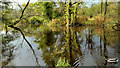
Damp ground, the Lagan Meadows, Belfast (1)
by Albert Bridge
geograph for square J3370
An area of damp ground, colonised by meadowsweet, in the middle part of the Lagan Meadows.
|

|
Wood anemone, Lagan towpath, Belfast (1)
by Albert Bridge
for square J3370
Some of the damp (and very damp) ground between the towpath and the Lagan... (more)
|

|
Damp ground, Crawfordsburn
by Albert Bridge
geograph for square J4681
Dampish ground, in a field on the western side of Crawfordsburn Country Park,... (more)
|

|
Collapsing trees, northeast corner of Priory Park, Warwick
by Robin Stott
geograph for square SP2865
Soft damp ground by St John's Brook has favoured willows, poplars, alder... (more)
|

|
Willows in the northeast corner of Priory Park, Warwick
by Robin Stott
geograph for square SP2865
Soft damp ground by St John's Brook has favoured willows, poplars, alder... (more)
|

|
Damp spot, Hillsborough forest
by Albert Bridge
geograph for square J2458
A damp spot, close to one of the paths, among the conifers and ferns of... (more)
|

|
Damp ground beside Templehill Wood
by Richard Sutcliffe
geograph for square NS5671
Looking towards the new houses at Kessington Gate. Beyond, the top of Boclair... (more)
|

|
Stagnant pool, Helen's Bay (June 2019)
by Albert Bridge
geograph for square J4482
A pool of stagnant brown water, in very soft and damp ground, beside the North... (more)
|

|
Fungi, Ormeau Park, Belfast (October 2017)
by Albert Bridge
for square J3473
Growing, in very damp ground, beside the Ormeau Embankment.
|

|
Boardwalk, Sixmilewater Park, Ballyclare (January 2017)
by Albert Bridge
geograph for square J2890
An elevated boardwalk, across damp ground, at the entrance to the Sixmilewater... (more)
|

|
Forget-me-not, Lagan towpath, Stranmillis, Belfast (August 2015)
by Albert Bridge
for square J3370
Water forget-me-not Link ... ( more) |

|
Damp ground between the railway and Lower Hayford Farm
by Christopher Hilton
geograph for square SJ3510
|

|
Yellow (flag) iris, Helen's Bay - June 2014(1)
by Albert Bridge
for square J4482
The distinctive flower of the yellow (flag) iris... (more)
|

|
Celandine, Comber
by Albert Bridge
for square J4668
One of the signs of spring - lesser celandine... (more)
|

|
Mossy trees, Dundonald
by Albert Bridge
for square J4173
Mossy trees, growing in very damp ground on the south western side of the Comber... (more)
|
|
Flood, Lagan towpath, Belfast
by Albert Bridge
geograph for square J3370
This spot, below ground level, between the towpath and the Lagan Meadows is... (more)
|

|
Redshank/redleg, Loughbrickland
by Albert Bridge
for square J1041
The wildflower redshank (also known as redleg)... (more)
|

|
Coastal grasses near Comber
by Albert Bridge
geograph for square J4767
|

|
American skunk cabbage, Hillsborough forest (2012-8)
by Albert Bridge
for square J2458
|

|
American skunk cabbage, Hillsborough forest (2012-7)
by Albert Bridge
for square J2458
One of a considerable growth, in very damp ground, near the southern side of the... (more)
|

|
American skunk cabbage, Hillsborough forest (2012-6)
by Albert Bridge
for square J2458
Part of a considerable growth, in very damp ground, near the southern side of... (more)
|

|
American skunk cabbage, Hillsborough forest (2012-5)
by Albert Bridge
for square J2458
This seems to be the start of a new growth of the plant, close to the southern... (more)
|

|
American skunk cabbage, Hillsborough forest (2012-2)
by Albert Bridge
for square J2458
One of the plants growing close to the western side of the lake. Taken, from... (more)
|

|
American skunk cabbage, Hillsborough forest (2012-1)
by Albert Bridge
for square J2458
Part of a growth of the plant, in very damp ground, close to the western side of the lake.
|

|
Fields and trees, Comber/Dundonald
by Albert Bridge
geograph for square J4371
Trees, fields and some damp ground on the northern side of the Belfast Road... (more)
|

|
Sheugh near Carryduff (February 2015)
by Albert Bridge
geograph for square J3763
A reasonably full sheugh on the eastern side of the Killynure Road. Most of the... (more)
|

|
Mallard, Lagan towpath, Belfast (5)
by Albert Bridge
for square J3370
One of several present in a shallow damp spot beside the towpath.
|

|
Cuckoo flower/Lady's Smock, Lambeg
by Albert Bridge
for square J2766
Cuckoo flower/Ladys Smock Link... ( more) |

|
Line of a brook near Marsh Farm
by Robin Stott
geograph for square SP2280
The footpath crosses a field full of Tufted Hair-grass or Tussock-grass... (more)
|

|
Great Burnet (Sanguisorba officinalis)
by Robin Stott
for square SP2067
The dark red blobs are unmistakeable. "In damp meadows, local." says... (more)
|

|
Flag iris, Lighthouse Island
by Albert Bridge
for square J5985
Yellow flag iris, coming into flower, in a damp spot well hidden by bushes.
|

|
Sheep below Knockagh (March 2015)
by Albert Bridge
for square J3787
|

|
Common marsh bedstraw, Belfast
by Albert Bridge
for square J3470
A low white flower which might be common marsh bedstraw... (more)
|

|
Drumlin and trees near Saintfield (2)
by Albert Bridge
for square J4057
A drumlin, rising above some dampish ground, on the eastern side of the Ballynahinch Road.
|

|
The edge of Templehill Wood
by Richard Sutcliffe
geograph for square NS5671
|

|
Block "A", University of Ulster site, Belfast (April 2015)
by Albert Bridge
for square J3374
A dampish Block A site seen through the viewing space in the York Street hoarding.
|

|
Farmland east of Hollowbarn Farm
by Christine Johnstone
geograph for square SP2010
The darker soil marks a slight valley, which is damper.
|

|
Cow near Crossgar
by Albert Bridge
for square J4453
One of a few, in a dampish field, on the north western side of the Glasswater... (more)
|

|
Water lilies, Moreland's Meadow, Belfast
by Albert Bridge
for square J3369
|

|
Pond, Moreland's Meadow, Belfast
by Albert Bridge
geograph for square J3369
|

|
Wood anemone, Lagan towpath, Belfast (2)
by Albert Bridge
for square J3370
|

|
Wet fields by Old Farm
by Karl and Ali
geograph for square SD3578
The land here is just above sea level and, after one of the wettest summers and... (more)
|

|
Wet field, Old Park
by Karl and Ali
geograph for square SD3478
Looking towards wooded Reake Hill and the distant Coniston fells.
|

|
The Loughshore near Comber (10)
by Albert Bridge
geograph for square J4767
|

|
The Loughshore near Comber (9)
by Albert Bridge
geograph for square J4767
The shore of Strangford Lough, seen from the Ballydrain Road, at Cattogs. The... (more)
|

|
American skunk cabbage, Hillsborough forest (2012-10)
by Albert Bridge
for square J2458
One of three small plants becoming established on the south western side of the lake.
|

|
Purple loosestrife, Orangefield Park, Belfast (September 2015)
by Albert Bridge
for square J3773
Purple loosestrife Link growing... ( more) |

|
Open space buffer between the A444 and Leaf Lane, Stivichall, Coventry
by Robin Stott
geograph for square SP3476
|

|
Open space between Leaf Lane and the A444, Stivichall, Coventry
by Robin Stott
geograph for square SP3476
A buffer between a residential area and the busy A444 dual carriageway,... (more)
|