Journal of Archaeological Science 45 (2014) 284e303
Contents lists available at ScienceDirect
Journal of Archaeological Science
journal homepage: http://www.elsevier.com/locate/jas
Klipdrift Shelter, southern Cape, South Africa: preliminary report on
the Howiesons Poort layers
Christopher S. Henshilwood a, b, *, Karen L. van Niekerk a, Sarah Wurz a, b, Anne Delagnes c, b,
Simon J. Armitage d, Riaan F. Rifkin a, b, Katja Douze b, Petro Keene b, Magnus M. Haaland a,
Jerome Reynard b, Emmanuel Discamps a, Samantha S. Mienies b
a
Institute for Archaeology, History, Culture and Religious Studies, University of Bergen, Øysteinsgate 3, N-5007 Bergen, Norway
Evolutionary Studies Institute, University of the Witwatersrand, 1 Jan Smuts Avenue, Braamfontein 2000, Johannesburg, South Africa
Université Bordeaux 1, CNRS UMR 5199 PACEA, Equipe Préhistoire, Paléoenvironnement, Patrimoine, Avenue des Facultés, F-33405 Talence, France
d
Department of Geography, Royal Holloway, University of London, Egham, Surrey TW20 0EX, UK
b
c
a r t i c l e i n f o
a b s t r a c t
Article history:
Received 23 October 2013
Received in revised form
29 January 2014
Accepted 31 January 2014
Available online 15 February 2014
Surveys for archaeological sites in the De Hoop Nature Reserve, southern Cape, South Africa resulted in
the discovery of a cave complex comprising two locations, Klipdrift Cave and Klipdrift Shelter. Excavations commenced in 2010 with Later Stone Age deposits initially being recovered at the former site and
Middle Stone Age deposits at the latter. The lithic component at Klipdrift Shelter is consistent with the
Howiesons Poort, a technological complex recorded at a number of archaeological sites in southern
Africa. The age for these deposits at Klipdrift Shelter, obtained by single grain optically stimulated
luminescence, spans the period 65.5 � 4.8 ka to 59.4 � 4.6 ka. Controlled and accurate excavations of the
discrete layers have resulted in the recovery of a hominin molar, marine shells, terrestrial fauna, floral
remains, organic materials, hearths, lithics, ochre, and ostrich eggshell. More than 95 pieces of the latter,
distributed across the layers, are engraved with diverse, abstract patterns. The preliminary results from
Klipdrift Shelter presented in this report provide new insights into the Howiesons Poort in this subregion and contribute further to ongoing knowledge about the complex behaviours of early Homo sapiens in southern Africa. Excavations at the Klipdrift Complex will continue in the future.
Ó 2014 The Authors. Published by Elsevier Ltd. Open access under CC BY-NC-ND license.
Keywords:
Middle Stone Age
Howiesons Poort
Homo sapiens
Modern human behaviour
Coastal subsistence
Southern Africa
1. Introduction
From 1998 to 2009 intermittent archaeological site surveys by
two of the authors (CSH and KvN) along 60 km of coastline located
in the De Hoop Nature Reserve, southern Cape, South Africa (Fig. 1)
resulted in the detailed mapping of more than 160 archaeological
sites. In 2010 two of the sites that comprise the Klipdrift Complex,
Klipdrift Shelter (KDS) and Klipdrift Cave (KDC), were selected for
test excavations (Figs. 1e3). The excavations form a part of the
Tracsymbols project, funded by a European Research Council FP7
grant (2010e2015) (http://tracsymbols.eu/), with one key aim being to initiate new excavations at Late Pleistocene archaeological
sites in southern Africa. The selection of the Klipdrift sites was
* Corresponding author. Institute for Archaeology, History, Culture and Religious
Studies, University of Bergen, Øysteinsgate 3, N-5007 Bergen, Norway. Tel./fax: þ27
21 4656067.
E-mail address: christopher.henshilwood@ahkr.uib.no (C.S. Henshilwood).
based on their visible, in situ Later Stone Age (LSA) and Middle
Stone Age (MSA) deposits, the preserved fauna and their relative
accessibility. In 2011 test excavations commenced at KDS (Figs. 2
and 3) revealing c. 1.6 m deep, well preserved, horizontal MSA
deposits immediately below the steeply sloping, eroded surface
(Fig. 4c). The clear separation of stratigraphic layers enabled the
accurate recovery of materials from discrete depositional layers.
The anthropogenic assemblage contained marine shells, terrestrial
faunal remains, microfauna, a human tooth, organic materials, ash
lenses and hearths, lithic artefacts, ochre and ostrich eggshell. In
2012 we initiated test excavations at a second MSA site within the
complex, Klipdrift Cave Lower (KDCL) (Figs. 2 and 3).
Here we report on the preliminary analysis of the materials
recovered from the KDS layers dated at 65.5 � 4.8 ka to
59.4 � 4.6 ka by single-grain optically stimulated luminescence
(OSL) (Fig. 4). The lithics are typical of those attributed to the
Howiesons Poort Industry (HP) in southern Africa. The research
emanating from this site has the potential of contributing to current
debates about the origins of modern human behaviour with a
http://dx.doi.org/10.1016/j.jas.2014.01.033
0305-4403 Ó 2014 The Authors. Published by Elsevier Ltd. Open access under CC BY-NC-ND license.
�C.S. Henshilwood et al. / Journal of Archaeological Science 45 (2014) 284e303
285
Fig. 1. Location of Klipdrift Complex and sites mentioned in the text.
specific focus on the Homo sapiens that inhabited the southern Cape
during the MSA. Excavations at KDS and at other sites within the
complex will continue in the future.
1.1. Site background
Evidence for human occupation of the De Hoop area from the
Acheulean is confirmed by handaxes found near Potberg (Fig. 1)
and the numerous LSA and fewer MSA sites distributed mainly
along the coast. The Klipdrift Complex is a major depository for Late
and Terminal Pleistocene sediments and archaeological deposits
that are visible both on the surface and in eroded sections. The
Complex is one of several caverns and overhangs along the
southern Cape coast formed within the 500e440 Million year (Ma)
Table Mountain Group (TMG) sandstones (Deacon and Geleijnse,
1988). Movement along the shear zones within the TMG forms
fault breccias susceptible to erosion by high sea levels leading to the
formation of caves within the near coastal cliffs (Pickering et al.,
2013). KDC and KDS are formed in the TMG sandstones, presumably as a result of this process. In the eastern section of De Hoop,
5 Ma hard dune ridges of Bredasdorp Group limestone infill these
TMG shear zones. The seaward extension of the limestone has been
truncated by marine erosion and in these coastal cliffs a number of
vadose caves have developed above the contact with the TMG
(Marker and Craven, 2002).
The Klipdrift Complex (34� 27.09630 S, 20� 43.45820 E), is located
in coastal cliffs 12e15 m from the Indian Ocean and c. 19 m above sea
level. The larger western cave is c. 21 m deep and contains at least
two sites, KDC and KDCL. KDS is a c. 7 m deep shelter, separated from
KDC and KDCL by a quartzite promontory (Figs. 2e4). The complex is
�286
C.S. Henshilwood et al. / Journal of Archaeological Science 45 (2014) 284e303
stimulated luminescence (OSL) age of 51.7 � 3.3 ka, the middle
layers containing the HP range from 65.5 � 4.8 ka to 59.4 � 4.6 ka
and the lowermost excavated, anthropogenically sterile layers give
an age of 71.6 � 5.1 ka (Fig. 4a).
1.2. Background: De Hoop Nature Reserve
Fig. 2. Klipdrift Cave and Klipdrift Shelter towards the north (upper) and west (lower).
located within the eastern section of the De Hoop Nature Reserve
(Fig. 1b) on Portion 20 of farm 516, Swellendam district in the
Overberg region of the southern Cape. Cape Town is c. 150 km to the
west; the Klipdriftfonteinspruit stream (namesake of the cave complex) and Noetsie waterfall (Scott and Burgers, 1993), which are
perennial sources of fresh water, lie about 200 m east of the Klipdrift
Complex. The extensive Breede River estuary and Blombos Cave lie
respectively 10 km and 45 km east/south-east (Fig. 1b).
In KDC archaeological deposits are concentrated behind the
dripline and extend over 280 m2 at a c. 25� slope. A c. 15 m talus
slopes seawards at 31.5� . In KDS visible surface deposits extend c.
7 m2 at a slope of c. 29� behind the dripline. The deposits are
severely truncated and the talus lies at 38.5� . It is probable that the
natural and archaeological deposits in the cave complex, especially
those in KDS, were truncated by mid-Holocene þ2e3 m sea levels
(Bateman et al., 2004; Compton, 2001). A quartzite cobble beach
lies directly below the complex with an extended rocky shoreline
and few sandy beaches. Initial excavations in KDC in 2010 yielded
Terminal Pleistocene deposits (Albany Industry) radiocarbon dated
at c. 14e10 ka (report in prep.). In 2013 several tons of rockfall were
removed in the area of the dripline in Klipdrift Cave (Fig. 3). A
limited test excavation in the Klipdrift Cave Lower (KDCL) site
revealed MSA deposits underlying the overburden. A provisional
minimum OSL age of c. 70 ka was obtained for the base of the
overburden. Further excavations of KDCL are planned.
KDS was first excavated in 2011 with subsequent seasons in
2012 and 2013. In total a volume of 2.3 m3 over an area of 6.75 m2
has been excavated at KDS to depths from 30 cm to 100 cm (in
individual quadrates) and more than 20 layers and lenses defined
(Figs. 3 and 4). The uppermost dated layer yields an optically
De Hoop Nature Reserve covers 34 000 ha and extends for 60 km
along the Indian Ocean coastline (Fig. 1b). The Potberg range, a
611 m high remnant of a syncline of the Cape Folded Belt composed
of highly resistant TMG quartzite, lies to the north-west of Klipdrift.
A major fault at the base of the range truncates it to the south. The
TMG quartzites form sea cliffs where they are exposed beneath the
Bredasdorp Group limestone. Sedimentary rocks of the TMG
(sandstones), Bokkeveld Group (shales) and Uitenhage Group
(mainly shale conglomerates) form the basement geology of the
area. Marine transgressions have planed the softer shales and
conglomerates into a gently southward sloping series of terraces.
The Neogene limestones of the Bredasdorp Group, deposited as
shallow marine environments (the Pliocene De Hoopvlei Formation
and the Pleistocene Klein Brak Formation, both of which are shelly
quartzose sand and conglomerate) and as coastal dunes (the Pliocene Wankoe Formation and the Pleistocene Waenhuiskrans Formation), underlie the greater part of the reserve (Marker and
Craven, 2002) and cover most of the Bokkeveld and Uitenhage
basement rocks. The Wankoe Formation forms the high-lying
aeolianites into which the coastal plain was eroded during marine transgressions. More recent dune systems (Waenhuiskrans
formation) were subsequently formed on the coastal plain. The
Strandveld Formation, deposited as a strip of unconsolidated dunes
during the Holocene is the most recent member of the Bredasdorp
Group (Bateman et al., 2004; Malan, 1990; Roberts et al., 2006;
Rogers, 1988).
The reserve is situated in the Cape Floristic Region, one of the six
floral Kingdoms in the world. It falls within a winter rainfall area
that has a Mediterranean climate. The current mean annual rainfall
is approximately 380 mm with the maximum in August and the
minimum in December and January. The warm Agulhas current
results in temperate winters and warm summers with an average of
20.5 � C during the latter and an average of 13.2 � C during winter.
The continental shelf, known as the Agulhas Bank (Fig. 1b), begins
as a relatively shallow topographical feature south of Port Elizabeth
and extends to the south and west beyond Cape Agulhas, 80 km
west of the Klipdrift Complex. At its widest point, south of Cape
Infanta (Fig. 1b), the Agulhas Bank extends more than 200 km
(Bateman et al., 2004; Carr et al., 2007; Compton, 2011; Van Andel,
1989).
Three major vegetation types occur in the reserve, Limestone
Fynbos, Mountain Fynbos, and Dune Fynbos/Thicket (Low and
Rebelo, 1996). A diversity of plants and animals, both terrestrial
and marine in a complex mosaic of different habitat types, is a
result of these varied geological features and the close location of
the reserve to Cape Agulhas, the meeting point of the west coast
cold Benguela and warm east coast subtropical Agulhas currents.
This diversity is illustrated by the 86 terrestrial mammal species
that occur here, at least 250 species of fish in the marine protected
area and the more than 260 resident and migratory bird species.
Limestone Fynbos, which is characterized by low shrubs, is the
predominant vegetation in the immediate vicinity of the Klipdrift
Complex (Willis et al., 1996).
2. Excavation methodology
Two grid systems, oriented on a local northesouth axis, were set
up using a Trimble VX Spatial Station. The first is a three-
�C.S. Henshilwood et al. / Journal of Archaeological Science 45 (2014) 284e303
287
Fig. 3. Topographical features of Klipdrift Complex including layout of excavated archaeological sites, Klipdrift Cave, Klipdrift Cave Lower and Klipdrift Shelter.
dimensional, numerical coordinate system, where the X and Y axes
are given arbitrary numerical values (50, 100), and the Z axis values
refer to elevation above sea level. The second, an alpha-numerical
system, consists of a continuous square metre grid starting from
A1, in which each square is further subdivided into four 50 � 50 cm
quadrates (named a, b, c and d) (see Fig. 4b).
Each quadrate was excavated individually by brush and trowel,
following stratigraphic layers. The layers within each quadrate
which contain sediments of several depositional events were
principally identified and defined by their texture, composition,
colour, thickness and content. The spatial extent of individual layers
varies throughout the excavated area and layer depths range from c.
2e30 cm. The layers were given alphabetically ordered name codes
(PAL, PBA, PCA etc.) (see Fig. 4). Name codes that share the two first
letters (e.g. PA and subdivisions PAL, PAM etc.) were interpreted as
having close contextual relationships. A micromorphological study
of these layers is in progress. Spatial measurements taken during
excavation refer to the numerical coordinate and were given a
three-dimensional (XYZ) spatial reference. Lithics >20 mm, identifiable bones, ostrich eggshell, ochre and artefacts of special interest were individually recorded with high precision (1/1000 cm)
and with an accuracy of �2 mm. Recovered finds or features were
bagged in plastic, labelled with provenance data and given a unique
specimen number. All plotted finds were classified on a primary
entry form in the field by raw material, species, tool type and
special characteristics. Non-plotted material (deposit/sediments)
was sieved through a nested 3.0e1.5 mm sieve and retained for
future analysis.
The topographic surface of a stratigraphic layer in a quadrate
was recorded by c. 500 3D points (point cloud) using the 3D
scanning function on the Trimble VX spatial station. The point
cloud was later converted into a 3D model of the entire layer surface for remodelling of the original surface topography. The surface
of each quadrate was also digitally photographed with a single lens
reflex camera (Nikon D4) with surface markers, permitting the
image to be geo-referenced and modelled in 3D. Similar photos
were taken of section walls, significant artefacts in situ and other
relevant features.
All site maps, cross sections and illustrations of the KDS stratigraphic sequence are geo-referenced within the numerical coordinate system and made by combining photogrammetric methods
with topographic data recorded by the total station. The Klipdrift
Complex and surrounds were mapped by scanning the site in 3D.
The point cloud that was generated (c. 250 000 points) was imported into Trimble RealWorks 6.5 and converted into a 3D mesh,
from which planar maps, cross-section of surface topography and
elevation models were produced. These were subsequently
exported as CAD files and imported into ESRI ARCGIS 10.1 for
further refinement, map making and for combining with georeferenced images (Figs. 3 and 4). Materials recovered from the
sites were primarily sorted and washed at the base laboratory situated at Potberg in the De Hoop Nature Reserve. On completion of
the excavations, the material was moved to our laboratory in Cape
Town for curation and further investigation. In the longer term the
recovered assemblages will be curated at the Iziko South African
Museum in Cape Town.
3. Optically stimulated luminescence dating
The MSA layers at KDS were dated using single-grain OSL.
Single-grain measurements were performed since previous OSL
dating studies conducted on southern African MSA sites demonstrate that multi-grain analyses are susceptible to a number of
sources of inaccuracy (e.g. Jacobs et al., 2008). These inaccuracies
may be avoided by measuring and analysing the OSL properties of a
sample at the single-grain level (Jacobs and Roberts, 2007).
3.1. Sample collection, preparation and measurement
Samples were collected from cleaned sections by scraping material into opaque bags while under tarpaulin. Sample locations are
listed in Table 1. Using the procedure outlined in Armitage et al.
�288
C.S. Henshilwood et al. / Journal of Archaeological Science 45 (2014) 284e303
Fig. 4. a) Stratigraphy of Klipdrift Shelter showing layers and optically stimulated luminescence ages; b) Location of excavated quadrates within KDS; c) excavated layers in section
showing the slope.
�C.S. Henshilwood et al. / Journal of Archaeological Science 45 (2014) 284e303
(2011) 212e180 mm diameter quartz grains were extracted from
bulk samples. Beta and gamma dose rates were calculated for each
sample using radioisotope concentrations measured by ICP-MS (U
and Th) and ICP-AES (K). Dose rates were corrected using an
assumed water content of 20 � 5%. This assumed value was
preferred to measured values since the latter are strongly dependent upon the time elapsed since the section was excavated and the
antecedent weather conditions. The assumed value is close to the
mean measured water content (19 � 6%) for a suite of 12 samples
from KDS, which with the inclusion of the 5% uncertainty term,
gives confidence that it approximates the true mean burial conditions. Gamma dose rates were corrected for a 20% volume of lowradioactivity clasts. Cosmic ray dose rates were calculated using
site location and overburden density, accounting for shielding by
the nearby rock face (Prescott and Hutton, 1994; Smith et al., 1997).
An internal alpha dose rate of 0.03 � 0.006 Gy/ka was assumed.
Equivalent doses were measured using the single-aliquot
regenerative-dose technique (Murray and Wintle, 2000) using a
Risø TL/OSL-DA-15 instrument (Bøtter-Jensen et al., 2003) fitted
with a single-grain OSL attachment (Duller et al., 1999, 2000).
Single-aliquot dose recovery tests (Roberts et al., 1999) were performed on every sample, and indicate inter-sample variability in
the optimal preheating regime, a phenomenon also observed at
Diepkloof Rock Shelter (Tribolo et al., 2013). Single-grain dose recovery tests, using the optimal measurement conditions identified
by the single-aliquot data, were performed on four samples and
yielded dose recovery ratios consistent with unity. Equivalent dose
(De) measurements were performed using the optimal preheating
regime identified for each sample. Data were screened using the
grain rejection criteria of Armitage et al. (2011). In addition, grains
were rejected where the sensitivity-corrected natural luminescence intensity exceeded twice the D0 value of the saturating
exponential fit to the growth curve (Wintle and Murray, 2006;
Chapot et al., 2012). Equivalent doses were calculated for grains
which passed these rejection criteria.
3.2. Estimation of the sample burial dose
All samples yielded sufficient data to calculate a meaningful De.
Where the overdispersion (sd, the relative standard deviation of
the true palaeodoses) of single-grain De values for a sample was
20% or less, all grains were assumed to belong to a single population
(following Olley et al., 2004), and the Central Age Model (CAM,
Galbraith et al., 1999) was used to calculate an equivalent dose for
that sample. Where overdispersion exceeded 20%, it was assumed
that more than one dose population was present, and the dataset
was analysed using the Finite Mixture Model (FMM, Roberts et al.,
2000). All datasets to which the FMM was applied were best fitted
with two De populations, and in each case a single dominant
289
population (�87% of accepted grains) was identified. The De
calculated for this population was considered most appropriate for
age determination. In samples KDS-DS7, 10 and 11, the remaining
grains belong to a small (2e8%) lower dose population, which was
interpreted to indicate the intrusion of lower dose grains from
above by bioturbation, though it is noteworthy that samples overlying KDS-DS10 (KDS-DS1, 2 and 9) do not contain similar populations. The small (7e13%) higher dose population present in
samples KDS-DS1, 2 and 9 was interpreted as indicating the presence of “partially bleached” grains.
Although 20% overdispersion has been widely used as a
threshold above which the FMM should be used, it has been argued
that this threshold is strictly only applicable to the Olley et al.
(2004) dataset. In addition, samples which cannot contain more
than one equivalent dose population occasionally yield overdispersion values above 20% (e.g. Armitage and King, 2013). However, inspection of radial plots for samples KDS-DS9 and 10 (Fig. 5a,
b) indicates that both the minor high and low De populations
identified by the FMM are clearly distinct from the population
containing the majority of the grains. Conversely, radial plots for
samples KDS-DS 3 and 12 (Fig. 5c, d), which were analysed using
the CAM, appear to show a single population of grains. These results
indicate that, for our dataset, the correct statistical model may
accurately be chosen using the overdispersion parameter. Ages for
the KDS samples are presented in Table 1.
4. Cultural artefacts
4.1. Lithics
This preliminary techno-cultural interpretation of the KDS
sequence is based on the lithics recovered in 2010 and 2011. Layers
PCA to PAY, ranging from 65.5 � 4.8 ka to 59.4 � 4.6 ka, provide
highly significant samples for a first technological assessment, with
11,687 lithics >2 cm in the seven layers considered here (Table 2).
Lithic raw materials are composed of five main groups:
quartzite, quartz, silcrete, cryptocrystalline silicate (CCS) and calcrete. In all layers, a large portion of the stone found derives from
the shelter’s walls, and are mostly quartzite and to a lesser extent
quartz. These coarse and poor quality raw materials were occasionally exploited by the knappers. Quartzite also includes finegrained types derived from pebbles, while quartz is predominantly composed of good quality types, with very fine crystalline
structure. Silcretes used by the KDS tool-makers are almost exclusively fine-grained types, frequently with internal cracks. Colour
variations include grey, yellow-brown, brown, red and green. Primary sources of silcrete and calcrete are present in abundance
along the Cape Fold Mountains (see Roberts, 2003) and near KDS
they occur as outcrops in small rocky hills some 10 km north and
Table 1
Summary equivalent dose data and ages for the KDS samples. Samples are listed in stratigraphic order: sd denotes overdispersion, while n is the number of grains which pass
the rejection criteria. The age models used are the Central Age Model (CAM) and the Finite Mixture Model (FMM). Uncertainties are based on the propagation, in quadrature, of
errors associated with individual errors for all measured quantities. In addition to uncertainties calculated from counting statistics, errors due to 1) beta source calibration (3%,
Armitage and Bailey, 2005), 2) ICP-MS/AES calibration (3%), 3) dose rate conversion factors (3%), 4) attenuation factors (2%, Murray and Olley, 2002) have been included.
Sample (KDS-.)
Square
Level
sd (%)
n
Age model
Grains in main
component (%)
Equivalent dose (Gy)
Dose rate (Gy/ka)
Age (ka)
DS11
DS12
DS3
DS2
DS1
DS9
DS10
DS7
Q27B
Q27B
R28C
R28C
R28C
R28C
R28C
S30A
PAN/PAO
PAS
PAY
PBA/PBB
PBC
PBD
PCA
PE
25
18
19
27
27
21
21
31
146
126
81
65
113
111
60
91
FMM
CAM
CAM
FMM
FMM
FMM
FMM
FMM
98 �
100
100
93 �
87 �
87 �
95 �
92 �
45.4
52.1
59.1
54.8
45.2
58.5
71.6
74.8
0.88
0.86
0.98
0.92
0.69
0.91
1.13
1.05
51.7
60.3
60.0
59.4
65.5
64.6
63.5
71.6
�
�
�
�
�
�
�
�
3
3
3
4
3
3
3
4
1
6
9
5
4
4
�
�
�
�
�
�
�
�
1.2
1.4
1.9
2.4
1.9
1.5
3.0
2.9
�
�
�
�
�
�
�
�
0.04
0.04
0.05
0.05
0.04
0.05
0.06
0.05
�
�
�
�
�
�
�
�
3.3
3.8
4.0
4.6
4.8
4.2
4.7
5.1
�290
C.S. Henshilwood et al. / Journal of Archaeological Science 45 (2014) 284e303
Fig. 5. Radial plots of equivalent doses for a) KDS-DS9, b) KDS-DS10, c) KDS-DS3 and d) KDS-DS12 of remaining deposits.
north-west of the site. Some of the knapped silcrete may originate
from pebble sources that have not yet been identified.
Significant changes occur in the relative proportions of these
raw material groups over time. Silcrete is dominant in the three
lower layers (PCA, PBE, PBD), while quartz increases significantly in
the two overlying layers (PBC, PBA/PBB), and quartzite as well as
calcrete become more abundant in the uppermost PAZ and PAY
layers (Table 2 and Fig. 6). These shifts in the sequence are even
more pronounced when considering the raw material distribution
of the blades and formal tools (backed tools and notched tools in
particular) (Fig. 6).
The lithic chaîne opératoire performed on quartz, silcrete and
CCS is almost entirely devoted to the production of blades, which is
confirmed by the strong predominance of blade cores in all layers
(PCA: 16/21 cores, PBE: 9/12, PBD: 35/47, PBC: 21/29, PBA/PBB: 26/
43, PAZ: 11/18, PAY: 9/17). The flaking method applied to blade
production is almost exclusively unidirectional and a number of
technical attributes, e.g. platform edge abrasion, weakly developed
bulbs and thin platforms, indicate the use of direct marginal percussion with a soft hammer, either mineral or vegetal. Core volume
exploitation is varied and includes unifacial cores with prepared
lateral convexities, semi-rotating cores, “narrow-face” cores and
bipolar cores. The mean width of blades is quite homogeneous
across raw materials and tends to be slightly higher in the four
uppermost layers (from PBC to PAY: Fig. 6). The elongation of blades
is high in all layers, with no significant pattern of change over time
(blades’ length/width in PCA: 2.7, PBE: 2.4, PBD: 2.5, PBC: 2.7, PBA/
PBB: 2.3, PAZ: 2.4, PAY: 2.5). Blades (Fig. 7: 1e12) range from very
small (length between 10 and 20 mm) to large (over 60 mm in
length). Besides blade production, secondary flake production occurs on quartz, silcrete and calcrete. It consists mainly of discoidal
and Levallois débitage. Discoidal cores occur in small quantities in
the whole sequence, unlike the Levallois cores which are limited to
the upper part of the sequence (layers PBC, PBA/PBB, PAZ, and PAY).
The existence of a secondary Levallois reduction sequence is
confirmed by the presence of Levallois flakes. These are very rare or
absent from layers PCA to PBA/PBB and amount to 5 Levallois flakes
in PAZ, and 24 in PAY. The top part of the sequence thus provides
evidence for the emergence of an independent and structured flake
reduction sequence. In contrast to other raw materials, quartzite
was predominantly used for producing flakes (Table 2) from
informal and unidirectional cores. Blade production on quartzite is
weakly developed in all layers, except in PAY where quartzite blade
production is relatively well represented. For both flake and blade
production, quartzite exploitation was based on expedient and
short reduction sequences performed with direct hard hammer
percussion.
The tools (Fig. 7: 13e27) are typical of the HP; formal tools are
composed of backed tools, notched tools, borers, retouched blades,
pièces esquillées and points. Retouched tools account for less than
5% of the assemblages (PCA: 3.5%, PBE: 2.5%, PBD: 2.8%, PBC: 3.2%,
PBA/PBB: 3.2%, PAZ: 5%, PAY: 2.6%). Some marked shifts occur in the
�C.S. Henshilwood et al. / Journal of Archaeological Science 45 (2014) 284e303
291
Table 2
Assemblage composition at KDS (the chunk category, which accounts for c. 40% of the total assemblage, has been eliminated from the quantitative analyses as it includes a
number of ambiguous items e natural slabs or knapping debris e especially for quartzite).
PAY
n
Flakes
Quartz
Silcrete & CCS
Calcrete
Quartzite
Blades
Quartz
Silcrete & CCS
Calcrete
Quartzite
Cores
Quartz
Silcrete & CCS
Calcrete
Quartzite
Tools
Quartz
Silcrete & CCS
Calcrete
Quartzite
Hammerstones
Subtotal
PAZ
%
n
PBA/PBB
%
n
PBC
%
n
PBD
%
n
PBE
%
PCA
n
%
n
%
67
97
34
318
8.9
12.9
4.5
42.3
178
60
15
136
33.9
11.4
2.9
25.9
631
71
59
316
40.9
4.6
3.8
20.5
152
44
1
265
23.6
6.8
0.2
41.1
145
250
0
560
7.9
13.6
0
30.4
81
79
6
204
10.2
10
0.8
25.8
104
97
0
220
13.9
12.9
0
29.3
22
69
15
88
2.9
9.2
2
11.7
35
32
9
16
6.7
6.1
1.7
3
312
29
17
29
20.2
1.9
1.1
1.9
66
44
0
27
10.2
6.8
0
4.2
150
556
3
80
8.1
30.2
0.2
4.3
117
238
0
36
14.8
30.1
0
4.5
66
186
1
36
8.8
24.8
0.1
4.8
10
7
5
4
1.3
0.9
0.7
0.5
8
10
0
1
1.5
1.9
0
0.2
41
4
1
0
2.7
0.3
0.1
0
17
9
0
4
2.6
1.4
0
0.6
14
34
0
8
0.8
1.8
0
0.4
6
6
0
0
0.8
0.8
0
0
9
7
0
0
1.2
0.9
0
0
0
9
2
3
1
751
0
1.2
0.3
0.4
0.1
100
6
12
3
2
2
525
1.1
2.3
0.6
0.4
0.4
100
23
6
0
4
1
1544
1.5
0.4
0
0.3
0.1
100
10
4
0
0
2
645
1.6
0.6
0
0
0.3
100
7
32
0
4
0
1843
0.4
1.7
0
0.2
0
100
0
15
0
1
3
792
0
1.9
0
0.1
0.4
100
2
20
0
0
2
750
0.3
2.7
0
0
0.3
100
e
e
e
e
e
135
22
8
288
12
465
e
e
e
e
e
e
e
e
e
e
83
12
5
382
11
493
e
e
e
e
e
e
e
e
e
e
127
22
0
522
17
688
e
e
e
e
e
89
35
0
358
16
498
e
e
e
e
e
Chunks
Quartz
Silcrete & CCS
Calcrete
Quartzite
Pebbles
Subtotal
141
10
25
936
14
1126
Total
1877
990
308
19
19
548
11
905
2449
1138
114
48
0
492
8
662
2505
Fig. 6. Technological changes in lithics at KDS, layers PCA to PAY.
1480
1248
�292
C.S. Henshilwood et al. / Journal of Archaeological Science 45 (2014) 284e303
Fig. 7. Blades and formal tools: 1: quartz blade, layer PBA/PBB; 2, 3, 4, 5, 7, 8: silcrete blades, layer PBD; 6, 9: silcrete blades, layer PBC; 10, 11, 12: silcrete blades, layer PCA; 13, 14:
quartz segments, layer PBC; 15: quartz segment, layer PBA/PBB; 16: quartz backed tool, layer PBA/PBB; 17: silcrete segment, layer PBD; 18: silcrete bi-truncated tool, layer PBD; 19,
20: silcrete truncated tools, layer PBE; 21,22: silcrete truncated tools, layer PCA; 23, 26: silcrete strangulated notches, layer PBE; 24: silcrete retouched blade, layer PBD; 25: silcrete
strangulated blade, layer PBD; 27: silcrete strangulated blade, layer PCA.
�C.S. Henshilwood et al. / Journal of Archaeological Science 45 (2014) 284e303
293
increase in the size of blades, the emergence of an independent and
structured flake production based on a Levallois concept, a decrease
in the proportions of backed tools and the presence of a few unifacial points. PAY could be interpreted as a transitional layer towards the post-HP. In between these phases, layers PBD and PAZ
appear as transitional layers, thus pointing to a process of gradual
change over time.
toolkit composition over time, both between and within tool
groups (Table 3). Backed tools include different types (Fig. 7: 13e
22), whose proportions vary consistently from one layer to another.
Segments (Fig. 7: 13e15, 17) are best represented in the middle part
of the sequence (layers PBD, PBC, PBA/PBB), with a peak in PBC
(Fig. 6) where they correspond to a small set of quartz segments
(n ¼ 7) with standardized morpho-dimensional attributes. Truncated blades (sensu Igreja and Porraz, 2013) are present in almost all
layers (PCA to PAZ). Within this category, a few highly standardized
silcrete tools are characterized by a proximal oblique truncation
opposite to a broken transverse distal part (Fig. 7: 19e22), which
are only present in the lower layers (PCA e n ¼ 3, PBE e n ¼ 2, PBD
e n ¼ 1). Notched tools (Fig. 7: 23, 25e27) are also diagnostic with
regard to patterns of change within the sequence (Fig. 6). They
represent a large majority of the retouched tools in the lower layers
(PCA and PBE with respectively 16/22 and 12/16 notched tools/total
of tools). In these two layers, notched pieces include typical
strangulated blades (Fig. 7: 23, 25e27) with multiple deep
retouched notches on one or two lateral edges of large silcrete
blades (PCA e n ¼ 7 including 1 calcrete tool, PBE e n ¼ 6). They also
occur in lesser proportions in PBD (n ¼ 1) and PBC (n ¼ 2), but are
totally absent in the uppermost layers. In all layers, notched tools
are predominantly made on silcrete blanks.
The shift from a notched tool-dominated toolkit (in PCA, PBE) to
a backed tool-dominated toolkit (in PBC, PBA/PBB) is closely
correlated with the inversion of the relative proportions of silcrete
to quartz in the same layers (Fig. 6). Few other categories of formal
tools are specific to certain layers. PBD in particular contains borers
in silcrete (n ¼ 2), quartz (n ¼ 2, including 1 crystal quartz) and CCS
(n ¼ 1). Silcrete blades with marginal continuous retouch on one
lateral edge (Fig. 7: 24) are almost exclusively present in PBD
(n ¼ 8), and occur rarely in both PCA (n ¼ 1) and PBC (n ¼ 1).
Unifacial points only occur in PAY (n ¼ 3) and are typical of the
“post-HP” period in southern Africa (see for instance Conard et al.,
2012; Lombard et al., 2012; Soriano et al., 2007; Villa et al., 2005).
Technological variations through time from PCA to PAY relate to
three main phases that can be included within the HP complex. The
lowermost phase (PCA, PBE) is characterized by the predominant
exploitation of silcrete for blade production, the prevalence of
notched tools, the presence of strangulated blades and of highly
standardized truncated blades. The following phase (PBC, PBA/PBB)
is marked by an increase in quartz exploitation which becomes the
most common raw material, while backed tools, including typical
segments, constitute the main tool group. The third and uppermost
phase (PAY) is defined by the predominance of quartzite, an
4.2. Ochre
Mineral pigments recovered from archaeological contexts are
generally termed ‘ochre’ and refer to rocks which derive their
colour from haematite (a e Fe) and goethite (a e FeO(OH))
(Eastaugh et al., 2008). The term describes earthy materials which
consist of anhydrous iron (III e ferric or Fe3þ) oxide such as red
ochre (unhydrated haematite or Fe2O3), partly hydrated iron (III)
oxide-hydroxide such as brown goethite (FeO(OH)) or hydrated
iron (III) oxide-hydroxide such as yellow limonite (Fe2O3(OH)
nH2O) (Cornell and Schwertmann, 2003).
An identified total of 356 pieces or 1756 g of ochreous material
was extracted during the 2011e2013 excavation seasons at KDS.
Ochreous deposits do not occur within the shelter and no sources
have been identified in the immediate vicinity of the complex.
Besides a ferricrete source 400 m to the east several ochreous
outcrops occur within 5e10 km of the site. Ochre sources are more
frequent within a 30 km radius of KDS, the most conspicuous being
the Bokkeveld Group deposits of the Cape Supergroup (Vorster,
2003). These comprise red ferruginous shales, siltstones, mudstones and haematised shales. The lowering of sea levels, for
example during MIS 5e, would likely have exposed Bokkeveld
shales within 0.5e1 km from the site.
All identified specimens heavier than 0.1 g were analysed and
are described in terms of weight and size, colour, geology and
processing technique employed. The analysed pieces comprise both
complete (such as hard ferruginous) and fragmentary (softer shales
and mudstones) specimens.
4.2.1. Stratigraphic frequency
The bulk of the assemblage derives from layers PBA/PBB followed by PCA and PBD (Table 4). By mass, layer PBE has the highest
concentration of red ochre (847.6 g) in the assemblage (48.3%). It
should be noted that by weight just over 90% of the ochre in layer
PBE consists of coarse to finely processed pieces weighing less than
0.1 g each. In terms of average mass the highest mean weights are
recorded in PBC (4.3 g) and PCA (3.2 g). The high standard
Table 3
Retouched tool composition at KDS (Q: quartz, S: silcrete, C: calcrete, Qi: quartzite) (backed tools may include localized or marginal retouch and oblique truncations may also be
proximal).
PAY
PAZ
PBA/PBB
PBC
PBD
PBE
PCA
Q
S
C
Qi
Q
S
C
Qi
Q
S
C
Qi
Q
S
C
Qi
Q
S
C
Qi
Q
S
C
Qi
Q
S
C
Qi
Segments
Backed tools
Oblique truncations
Single notches
Denticulates
Strangulated blades
Borers
Retouched blades
Unifacial points
Burins
Pièces esquillées
Scrapers
Miscellaneous
1
e
e
e
e
e
e
e
e
e
e
e
e
e
1
e
2
e
e
e
e
2
1
e
e
5
e
e
e
e
e
e
e
e
e
e
e
e
4
e
e
e
e
1
e
e
e
1
e
e
1
1
1
2
1
e
e
e
e
e
e
e
e
e
4
1
4
e
1
e
e
e
e
e
2
e
1
5
e
e
e
1
e
e
e
e
e
e
1
1
e
e
e
e
e
e
e
e
e
e
e
e
1
1
4
17
1
3
3
e
e
e
e
e
e
2
1
1
1
e
2
1
e
e
e
e
e
1
2
3
e
e
e
e
2
e
e
e
e
e
e
1
e
e
e
e
e
1
e
e
e
e
e
1
1
2
7
1
2
1
e
e
e
e
e
1
1
1
1
e
1
1
1
e
2
e
1
e
e
e
e
e
e
e
e
e
e
e
e
e
e
e
e
e
e
e
e
e
e
e
e
e
e
e
e
e
e
e
1
3
e
e
e
e
2
e
e
e
1
e
e
3
4
1
1
2
1
3
8
e
e
5
1
12
e
e
e
e
e
e
e
e
e
e
e
e
e
1
e
e
e
2
e
e
e
e
e
e
1
e
e
e
e
e
e
e
e
e
e
e
e
e
e
1
3
2
6
e
6
e
e
e
e
e
e
1
e
e
e
e
e
e
e
e
e
e
e
e
e
e
e
e
e
e
e
e
e
e
e
e
e
1
e
e
e
e
e
e
e
e
e
e
e
e
2
1
e
3
8
1
6
e
1
e
e
e
1
3
e
e
e
e
e
1
e
e
e
e
e
e
e
e
e
e
e
e
e
e
e
e
e
e
e
e
Total
1
11
4
4
8
14
3
2
31
11
3
5
15
6
0
0
7
41
0
4
0
19
0
1
2
24
1
0
�294
C.S. Henshilwood et al. / Journal of Archaeological Science 45 (2014) 284e303
Table 4
Ochre frequency by weight, size and stratigraphic layer.
Layer
Total (n)
Total (g)
Mean (g)
Std. dev.
Mean (mm)
Std. dev.
PAY
PAZ
PBA/PBB
PBC
PBD
PBE
PCA
17
12
113
19
59
39
97
13.4
21.2
248.7
126.7
182.2
847.6
316.3
0.8
1.8
2.2
4.3
1.7
1.6
3.2
1.6
3.2
5.4
11.5
5.1
7.5
8.9
16.4
16.8
15.4
23.5
17.4
12.9
19.1
5.7
10.4
8.3
14.4
9.1
8.8
10.5
356
1756.1
2.2
e
17.3
e
deviations in weight for layer PBC and also PCA indicate that
specimens range substantially in terms of weight and therefore
size, and possibly also in terms of intensity of processing. The
lowest average weights occur in layers PAY (0.78 g) and PBE (1.6 g).
The heaviest individual pieces derive from layer PCA (79.5 g), followed by PBE (38.5 g), PBC (35.7 g), PBA/PBB (29.2 g) and PBD
(17.3 g). The least heavy examples originate from layers PBD, with
41 pieces weighing <0.5 g, and PCA with 36 pieces <0.5 g.
In terms of average size, the largest grouping is that from layers
PBC (23.5 mm) and PCA (19.1 mm), followed by PBD, PAZ and PAY at
17.4 mm, 16.8 mm and 16.4 mm respectively (Table 4). Layers PBA/
PBB (12.3 mm) and PBE (12.9 mm) contain the smallest mean sizes
of ochre pieces. The largest pieces are from layer PCA (74.6 mm) and
the smallest from PBA/PBB (1.0 mm). Note the high standard deviations in size for layers PAZ, PBC and PCA.
4.2.2. Geological profiles and colour categories
Six raw material categories are discerned, namely fissile shale,
indurated shale, mudstone, ferricrete, haematite and sandstone.
Fine-grained and soft (2e3 on Moh’s hardness scale) sedimentary
forms including fissile shale (53%), indurated shale (22.9%) and
mudstone (14.5%) accounts for 90.3% of the raw material assemblage (Fig. 8a). Harder (>4 on Moh’s scale) and essentially coarsegrained forms such as ferricrete (2.4%), haematite (2.4%) and
sandstone (4.8%) constitute the remainder (9.7%) of the assemblage. Layers PAY to PCA display marked geological variability, with
all six geological categories occurring in layers PBC, PBD and PCA.
Layer PBC exhibits the highest frequencies of ferricrete (5.3%) and
Fig. 8. Ochre recovered from KDS indicated stratigraphically and according to a) raw material frequencies and b) colour. (For interpretation of the references to colour in this figure
legend, the reader is referred to the web version of this article.)
�C.S. Henshilwood et al. / Journal of Archaeological Science 45 (2014) 284e303
295
Fig. 9. Examples of processed ochre pieces from KDS: a) coarse-grained ground purple shale cobble (PCA), b) ground and polished shale-derived crayon-like piece (PBC), c) ground
and scraped soft shale-derived specimen (PCA), d) ground hard shale chunk (PBE) e) knapped and ground haematite-rich shale fragment (PBC). (For interpretation of the references
to colour in this figure legend, the reader is referred to the web version of this article.)
sandstone (31.6%). PBE displays the greatest proportion (91.3%) of
red ochre derived from fissile and indurated shales.
Colour was collapsed into ten groups including red, maroon,
purple, pink, white, orange, yellow, brown, grey and black (Fig. 8b).
Geological and colorimetric relationships could not be objectively
ascertained, principally because destructive analytical methods are
required to determine such variables (Dayet et al., 2013). Basic visual classification and comparison with the Natural Colour System
(NCS) Digital Atlas (http://www.ncscolour.com, 2013) was therefore used for colour classification in this study. Although visible
spectroscopy can provide the absorbance spectra and colour parameters of the ochre assemblage, this method will only provide
information concerning the colorimetric properties of the external
surfaces of the specimens. Red (62%) is the predominant colour,
followed by maroon (15.3%), orange (4.5%) and pink (4.5%). The
remainder of the assemblage (13.7%) includes lighter (yellow and
white) and darker (brown and black) categories. The majority (77%)
of red pieces are derived from fissile shales.
4.2.3. Utilization strategies
Ochre at KDS occurs in the form of residual powder, nodules,
and fragments or as inclusions in larger pieces of rock (Fig. 9). Some
examples show signs of grinding on hard abrasive surfaces or
scraping with sharp-edged implements. Indications of ochre processing by grinding or scraping (n ¼ 20) or by deliberate knapping
(n ¼ 31) have been identified at KDS.
The proportion of modified pieces (17.5%) is well within the
range of other MSA sites (w14%) (Watts, 2002, 2009, 2010;
Hodgskiss, 2010; Dayet et al., 2013) (Table 5). Similar to the MSA
Table 5
The prevalence of processed ochre pieces per layer.
Layer
n
Ground
%
Crayons
%
Flakes
%
PAY
PAZ
PBA/PBB
PBC
PBD
PBE
PCA
17
12
113
19
59
39
97
1
1
6
4
1
1
5
5.9
8.3
3.9
21.1
3.4
2.6
6.2
e
e
3
2
2
1
3
e
e
3.9
10.5
3.4
2.6
2.1
e
e
20
e
5
1
5
e
e
19.6
e
8.5
2.6
5.2
356
19
6.2
11
3.0
31
8.3
at Diepkloof (Dayet et al., 2013) Sibudu (Hodgskiss, 2010), Blombos
(Watts, 2009) and Pinnacle Point (Watts, 2010), grinding is the
primary processing technique. Of the ground pieces including
crayons, 67.7% comprise fissile shale, 12.9% indurated shale, 6.5%
mudstone and sandstone respectively and 3.2% haematite and
ferricrete respectively. Fissile and indurated shales appear to have
been preferentially processed by grinding (80.6%). In addition,
81.8% of ochre crayons comprise soft to hard red fissile shales. At
Diepkloof and Sibudu scraping is not a primary processing technique and the presence of only a single scraped piece at KDS (layer
PBD) is therefore not unusual. Clear indications of knapping occur
on 31 pieces from layers PBA/PBB (n ¼ 20), PBD (n ¼ 5), PBE (n ¼ 1)
and PCA (n ¼ 5), suggesting that knapping may have formed part of
the chaîne opératoire of ochre processing in these layers (Fig. 9e).
4.3. Ostrich eggshell
We have identified 95 fragments of clearly and deliberately
engraved ostrich eggshell (EOES) recovered from layers PAY to PCA
(3.8% of the total number of OES fragments). The majority of the
EOES pieces derive from PBC (27%) and PBD (25%) (Table 6). An
additional 6 engraved pieces were recovered from layer PAX (not
reported here), and no EOES fragments were recovered from any of
the layers above PAX. The EOES is spatially distributed across the
area where HP layers were excavated (4.75 m2) and up to 50 cm
below the surface. There are no LSA deposits in KDS and during
excavation there was no sign of disturbance to the deposits that
might have resulted from the intrusive burial of engraved eggs at
the site by LSA people. The EOES fragments are under study but
preliminary observations can be made. The designs entail variations of cross-hatched or sub-parallel line themes, and most are
similar to those reported from Diepkloof in the HP and pre-HP
layers (Texier et al., 2010, 2013) and from the HP layers at Apollo
11 (Vogelsang et al., 2010). All the designs identified at Diepkloof
(Texier et al., 2013, Table 4: 3423) are present at KDS, except for the
“sub-parallel intersecting lines motif”. One design present in the
upper layers at KDS, not reported from Diepkloof, consists of a
finely carved diamond shaped cross-hatched pattern (Fig. 10a,b),
distinctly different to those from layers below, and from the
“crosshatched grid motif” reported from Diepkloof (Texier et al.,
2013: 3420). This diamond shaped pattern is present only in
layers PAX, PAY and PAZ. In PAX and PAY this is the only engraved
�296
C.S. Henshilwood et al. / Journal of Archaeological Science 45 (2014) 284e303
Table 6
Frequency of engraved and unmodified OES throughout the sequence.
Layer
EOES (n)
OES (n)
% EOES
PAY
PAZ
PBA/PBB
PBC
PBD
PBE
PCA
5
15
22
23
25
4
1
106
187
1274
349
202
90
282
4.7
8.0
1.7
6.6
12.4
4.4
0.4
Total
95
2490
3.8
motif present. The “sub-parallel rectilinear or curved lines” design
at Diepkloof (Texier et al., 2013: 3423) is the most commonly
occurring motif in layers PBC to PAZ at KDS. Our study of the EOES is
ongoing but initial observations suggest similarities with many of
the EOES motifs found at Diepkloof, with some differences.
5. Fauna
5.1. Macrofauna
A preliminary analysis of the macrofaunal remains from the PAY
to PCA layers was conducted following Driver (2005) and Klein and
Cruz-Uribe (1984). The comparative faunal collections of the Ditsong Museum of Natural History in Pretoria were used to identify
bone remains. Micromammals, defined as species where adults
weigh less than 750 g, are not included in this analysis. Because of
the difficulty in differentiating bovids, many remains were assigned
only to size classes based on Brain (1974). Size class 1 includes small
bovids such as Cape grysbok (Raphicerus melanotis), size 2 includes
southern reedbuck (Redunca arundinum), size 3 includes red
hartebeest (Alcelaphus buselaphus), and size 4 are large bovids such
as eland (Tragelaphus oryx) and African buffalo (Syncerus caffer).
Although eland is sometimes identified as Taurotragus oryx, we
follow the classification scheme of Skinner and Chimimba (2005) e
based on genetic studies (e.g., Essop et al., 1997) e and classify
eland as Tragelaphus oryx. We also use the size 5 class for very large
bovids, such as the extinct long-horned buffalo (Syncerus antiquus).
Long-horned or giant buffalo are also known as Pelorovis antiquus
but we follow more recent studies that assign them to the genus
Syncerus (Gentry, 2010; Rector and Reed, 2010; Faith, 2013). Due to
the fragmentary nature of the assemblage, many mammal remains
such as rib, cranial or vertebral fragments could not be identified
beyond class. These specimens are classified as ‘small’, ‘medium’,
‘large’ or ‘very large mammal’ based on size. Small mammals are
defined as indeterminate specimens ranging in size from the Cape
dune molerat (Bathyergus suillus) up to and including size 1 bovids,
medium mammals up to size 2 bovids, and large mammals are size
3 bovids and larger (Brain, 1974). ‘Very large mammal’ includes a
specimen that could not be confidently identified to order and may
be black rhinoceros (Diceros bicornis) or long-horned buffalo. Small
carnivores range in size to that of the African wild cat (Felis silvestris), medium carnivores to the size of the African civet (Civettictis civetta) and large carnivores as larger than C. civetta. A few
fish remains were recovered at KDS, mainly vertebrae and jaw
bones, but these have not been studied.
5.1.1. Assemblage
Of the 28,128 fragments of bone, weighing 11,758 g, 2129 (7.6%)
could be identified to at least the class level, while 292 (1.0%) could
be identified to genus/species. Bone from KDS is extensively fragmented: the majority of identified fragments (n ¼ 1343; 63.1%) are
less than 2 cm in length and 19.7% of identified bone (n ¼ 419) is
less than 1 cm long. This extensive fragmentation is likely the
reason why the Minimum Numbers of Individuals (MNI) in all
layers is lower than expected (Marshall and Pilgram, 1993). Fragmentation is probably a result of burning with evidence present on
1761 fragments (82.7% of identified bone). Although burning was
not recorded for unidentified bone, the proportion of unidentified
burnt specimens appears much the same as in the identified
sample. The elevated proportion of burnt bone is likely due to the
high numbers of hearths and hearth-like structures occurring at
KDS. Most of the faunal material was recovered from within, or
close to, these hearths suggesting that most of the burnt bone can
be associated with cooking events. This, and the relative lack of
carnivores, is a strong indicator that humans were the main accumulators of the faunal assemblage.
5.1.2. Identified fauna
Tortoise remains are common and constitute 31% of the identified fauna (Table 7). The majority of identified tortoise bones are
carapace or plastron but due to their small size it was not possible
to differentiate tortoise taxa based on shell fragments. Most of
these are likely angulate tortoise (Chersina angulata), although
some may be the Cape tortoise (Homopus sp.). Rock hyrax (Procavia
capensis) is the most prevalent identified macromammal. Layers
Fig. 10. Engraved OES pieces from PAZ (a and b), PBC (c and d) and PBD (e and f). Note that both c and d consist of two refitted parts.
�C.S. Henshilwood et al. / Journal of Archaeological Science 45 (2014) 284e303
297
Table 7
The Number of Identified Specimens (NISP) and the Minimum Number of Individuals (MNI) for macromammal and tortoise remains. Bovid size classes exclude specimens that
could be identified to genus/species. Small, medium, large and very large mammals include specimens such as cranial, rib and vertebral fragments that could not be confidently
identified beyond class. Linnaean classification based on Skinner and Chimimba (2005) except Syncerus antiquus (Gentry, 2010).
Taxa
Common name
PAY
MNI
NISP
MNI
Testudinidae
Chersina angulata
cf. Pelomedusidae
Lagomorpha
Lepus saxatilis
Lepus sp.
Bathyergus suillus
Procavia capensis
Tortoise
Angulate tortoise
Turtle
Hare/Rabbit
Scrub hare
Hare
Cape dune molerat
Rock hyrax
Small mammal
Mongoose
Small carnivore
Caracal/Serval
Cape fur seal
Medium carnivore
Medium mammal
Brown hyena
Black rhinoceros
Zebra
Steenbok/Grysbok
Grey duiker
Klipspringer
Oribi
Grey (Vaal) rhebok
Reedbuck
Mountain reedbuck
Southern reedbuck
Hartebeest/Wilderbeest
Black wildebeest
Red hartebeest
Bles or bontebok/?D. niro
Bontebok/Blesbok
Eland
Giant buffalo
Bovid 1
Bovid 1/2
Bovid 2
Bovid 2/3
Bovid 3
Bovid 3/4
Bovid 4
Large mammal
Very large mammal
2
2
e
1
e
e
2
3
3
e
e
e
e
e
2
e
e
e
1
e
e
e
e
e
e
e
e
e
e
e
e
e
e
2
e
3
e
1
e
1
2
e
59
10
e
1
e
e
8
22
41
e
e
e
e
e
16
e
e
e
1
e
e
e
e
e
e
e
e
e
e
e
e
e
e
9
e
13
e
6
e
1
5
e
1
2
e
e
e
e
1
2
2
e
e
1
e
1
2
e
e
e
1
e
e
e
1
e
e
e
e
e
e
e
1
e
e
1
e
1
e
2
e
1
1
e
25
192
21
81
Herpestidae sp.
Felis cf. caracal/serval
Arctocephalus cf. pusillus
Parahyaena brunnea
Diceros bicornis
Equus sp.
Raphicerus sp.
Sylvicapra grimmia
Oreotragus oreotragus
Ourebia ourebi
Pelea capreolus
Redunca sp.
Redunca fulvorufula
Redunca arundinum
Alcelaphini sp.
Connochaetes gnou
Alcelaphus buselaphus
Damaliscus sp.
Damaliscus pygargus
Tragelaphus oryx
cf. Syncerus antiquus
Total
PAZ
PAY and PAZ are dominated by micromammal remains, and small
mammals such as hyrax and Cape dune molerat with a few identified bovid bones. Lagomorph remains were recovered from PAY,
PBC, PBD and PCA with one specimen identified as scrub hare
(Lepus saxatilis). Equids (Equus sp.) are common in layers PBA/PBB
and PBC and many of the ‘large mammal’ rib and vertebral fragments in these layers are probably equid remains. Based on variation in long bone and metapodia sizes, it is likely that the quagga
(Equus quagga quagga) or plains zebra (Equus quagga burchellii) and
mountain zebra (Equus zebra) may be present but the fragmented
nature of the bones prevents positive identification. It is unclear
whether the Cape zebra (Equus capensis) is present.
Cape grysbok or steenbok (Raphicerus sp.) occur in most layers
and are most common in PBC, PBD and PBE. A single oribi (Ourebia
ourebia) phalange was identified in PBA/PBB with sufficient
morphological traits to distinguish this specimen from grey duiker
(Sylvicapra grimmia), klipspringer (Oreotragus oreotragus) or the
more common Raphicerus. Larger bovids are relatively more common in PBA/PBB, PBC and PCA. Blesbok or bontebok (Damaliscus
pygargus) remains were recovered from these layers. One
PBA/PBB
PBC
PBD
PBE
PCA
NISP
MNI
NISP
MNI
NISP
MNI
NISP
MNI
NISP
MNI
NISP
23
4
e
e
e
e
1
11
8
e
e
1
e
2
8
e
e
e
1
e
e
e
1
e
e
e
e
e
e
e
1
e
e
1
e
4
e
10
e
2
3
e
2
2
e
e
e
e
e
1
3
e
1
e
e
e
3
1
e
2
1
1
e
1
1
1
1
e
1
e
1
1
1
e
1
2
e
3
1
3
2
1
2
1
71
8
e
e
e
e
e
1
33
e
1
e
e
e
134
1
e
10
1
2
e
1
3
3
1
e
3
e
1
3
1
e
1
18
e
42
2
20
7
3
25
1
2
2
e
2
e
1
e
3
3
e
1
1
e
1
3
e
1
3
2
e
e
e
e
e
e
1
1
1
1
e
1
e
e
2
e
2
1
2
e
e
3
e
51
11
e
4
e
1
e
27
78
e
2
1
e
1
80
e
2
25
6
e
e
e
e
e
e
1
2
1
1
e
2
e
e
15
e
31
7
29
e
e
45
e
3
2
1
1
e
1
e
2
3
1
e
e
1
e
2
e
e
1
1
1
1
e
e
1
e
e
1
1
1
e
e
e
e
3
e
3
1
2
1
1
2
e
251
21
1
3
e
1
e
30
78
1
e
e
2
e
64
e
e
2
7
2
4
e
e
1
e
e
1
1
2
e
e
e
e
62
e
30
3
45
7
4
23
e
2
2
e
e
e
e
e
1
2
e
1
e
e
e
2
e
e
e
1
e
e
e
e
e
e
e
e
1
e
e
e
1
e
2
e
1
e
1
1
1
2
e
105
8
e
e
e
e
e
1
8
e
1
e
e
e
17
e
e
e
5
e
e
e
e
e
e
e
e
1
e
e
e
1
e
7
e
14
e
2
1
3
6
e
1
1
e
1
1
e
e
1
2
e
e
e
e
e
3
e
e
1
e
e
e
e
1
e
e
e
1
e
1
e
1
1
e
1
1
2
1
1
1
1
1
e
24
3
e
3
1
e
e
6
31
e
e
e
e
e
30
e
e
2
e
e
e
e
2
e
e
e
1
e
1
e
1
4
e
4
1
40
4
40
6
19
7
e
41
397
40
423
38
646
21
180
25
230
Damaliscus tooth fragment was noticeably larger than D. pygargus
but smaller than tsessebe (Damaliscus lunatus) and may be the
extinct blesbok (Damaliscus niro). Reedbuck (Redunca sp.) occurs in
PBA/PBB and PBD. The vertebral fragment assigned to ‘very large
mammal’ likely belongs to long-horned buffalo. Regarding alcelaphines, hartebeest was distinguishable from black wildebeest
(Connochaetes gnou) by tooth morphology. For example, enamel
infolds, particularly on the mesial region of the buccal surfaces of
molars, are more pronounced in hartebeest than wildebeest. The
relatively high number of ‘large mammal’ rib and vertebral specimens in layers PBA/PBB and PBC is probably related to the alcelaphines recovered from those layers. Eland remains are relatively
more common in PCA and suggest that the other unidentified size 4
bovid specimens from that layer are also most likely eland since no
African buffalo have been identified.
5.1.3. Comparisons with other sites
As is the case at KDS, small mammals (particularly dune molerat
and hyrax), small bovids and tortoise are common in the pre-70 ka
MSA layers at Blombos (Henshilwood et al., 2001; Thompson and
�298
C.S. Henshilwood et al. / Journal of Archaeological Science 45 (2014) 284e303
Henshilwood, 2014), in the HP layers at Diepkloof (Steele and Klein,
2013) and at Die Kelders (Klein and Cruz-Uribe, 2000). Of the large
bovids recovered, eland is relatively common at Blombos, Die
Kelders and Diepkloof but rare at KDS. In contrast, equid, quite
common at Diepkloof and KDS, is only present in the earlier
(w100 ka) M3 phase at Blombos and rare at Die Kelders. The
prevalence of equids at KDS and within the HP layers at Diepkloof
suggests a grassier environment during this period. Damaliscus
does not occur at either Diepkloof or Blombos but is present at Die
Kelders and KDS. While African buffalo occur at Blombos and Die
Kelders, remains have not been recovered from KDS. Future studies
of KDS fauna will include assessment of skeletal profiles and surface
modification patterns.
5.2. Shellfish
The shellfish data presented are a sample of the material
retained in the 3 mm sieve from a number of quadrates (between
four and six per layer) spanning the sequence from PCA to PAY. This
data represents 32.4% of the total volume excavated from these
layers. Just over 29 kg of shellfish has been analysed from a volume
of 0.51 m3 and 7 layers. Shells were weighed and quantified by
determining the minimum number of individuals (MNI) per layer,
based on counting the apices of gastropods, the left and right
umbos of bivalves with the most common side taken as the MNI,
and the highest number of either front, back or middle valves
(middle valve counts were divided by 6) of chitons was taken as the
MNI. Both apices and opercula of the giant periwinkle Turbo sarmaticus were counted and the highest count taken as the MNI. The
greatest dimensions of intact limpets and opercula were measured
with digital callipers to the nearest millimetre. Shells that were
<2 cm (whole) were not considered to be food items and were
recorded as incidental shells or juvenile limpets.
In total, excluding the incidental and juvenile shells, 14 species
of shellfish were identified (Table 8). Note that although two
periwinkle species, Diloma sinensis and Diloma tigrina, are present,
their data have been combined as the countable apices are not
identifiable to species level when the shells are broken. Overall, the
most common species, in terms of MNI (absolute, per m3 and in
terms of relative frequency), is the giant chiton, Dinoplax gigas,
followed by the brown mussel, Perna perna, and T. sarmaticus. By
weight, the most common species is the abalone, Haliotis midae,
followed by D. gigas, and T. sarmaticus.
H. midae, D. gigas and T. sarmaticus are consistently the most
common by weight relative to other species within layers, although
frequencies differ between layers. As they are all relatively large
animals with heavy shells, their dominance by weight is not that
surprising, although they tend to dominate the assemblage in
terms of MNI as well. Only in PAY is the Argenville’s limpet, Scutellastra argenvillei, which is rare or absent in other layers, the
second most common in terms of weight (38%). This could be a
function of the smaller sample size in PAY. In terms of MNI, the
range of the most common species is more varied between layers,
but in most instances D. gigas and T. sarmaticus are most common,
but the relative percentage of P. perna increases in most layers. Four
species, the black mussel Choromytilus meridionalis, sand mussel
Donax serra, kelp limpet Cymbula compressa and bearded limpet
Scutellastra barbara are present in such small quantities that their
contribution to the diet of the KDS occupants would have been
minimal.
There is a shift in the relative percentage by weight of the three
most common species e at the base of the sequence, PCA,
T. sarmaticus is the most common, in PBE and PBD H. midae is the
most common, in PBC D. gigas is only slightly more common than
H. midae, and in all the layers above D. gigas is the most frequently
occurring species by weight (Fig. 11). The same shift is evident from
the density data (g/m3) of these species.
5.2.1. Densities by layer
There is little or no shellfish present in layers below PCA. That
which has been recorded is thought to derive from PCA above,
where PCA and PCB could not be separated. Densities are considerably higher in layers PBC and PBD, with 183 kg/m3 and 181 kg/m3
respectively, than in any other layers (Table 8), and gradually decreases towards the top of the sequence, with less than 3 kg/m3 in
PAY. Shellfish volumes decrease drastically above PAY (<1 kg/m3),
and only increase again in layers PAQ (1.4 kg/m3) and above (up to
12.2 kg/m3 in PAL). Notwithstanding the effects of volume reduction over time and geomorphological processes that cannot be
accounted for, PBC and PBD are very dense shell layers, both relative to other layers within this site, as well as to other MSA sites
with shellfish remains and published volumes. At Klasies River, the
highest recorded density of shellfish is in the MSA II, at 162 kg/m3
(Thackeray, 1988). The HP layers at Klasies River show a gradual
decline in shellfish volumes through time, starting at 8.7 kg/m3 in
the lower layers, and ending in 0.8 kg/m3 in the uppermost HP
layers. At Blombos, shellfish volumes are highest in layer CI in the
M3 phase, c. 100 ka, at 163.8 kg/m3 (Henshilwood et al., 2001), and
lower in the M2 (c. 80 ka) and M1 (c. 75 ka, Still Bay) phases, with
31.8 kg/m3 and 17.5 kg/m3 respectively. At Pinnacle Point Cave
PP13B, in layers dating between 90 and 164 ka, shell densities are
relatively low, ranging from 0.01 kg/m3 to 8.7 kg/m3 (Jerardino and
Marean, 2010). Shellfish data have not been provided for the HP
layers at Pinnacle Point Site PP5e6, but densities appear to be low
(Brown et al., 2012).
Although the density of shellfish declines with time, the species
composition does not indicate a change in the distance from the
shore significant enough to result in changes in collection strategies, for example an increase in P. perna, which can be transported
over greater distances, or a decrease in large high yield species
when distances exceed 5 km (Langejans et al., 2012).
5.2.2. Shellfish size
It has been argued that reductions in shellfish size can be used
as a proxy for intensification of shellfish gathering and increased
group size (e.g. Klein and Steele, 2013), although some suggest that
the role of environmental factors on shellfish growth rates might be
more significant than previously considered (Sealy and Galimberti,
2011). The number of measurable shells from the current sample is
small, but has been included here for completeness. Very few of the
Cymbula granatina shells were intact enough for measurement, and
all are from PBD and PBC. From the small measurable sample
(n ¼ 10), the median is 67.5 mm, mean 67.4 mm, minimum 57 mm
and maximum 79 mm. These sizes are smaller than the average of
modern C. granatina from unexploited areas on the Cape west coast
(Parkington et al., 2013), and somewhat smaller than those reported from MSA contexts on the west coast, except for Boegoeberg
2, where sizes are similar (Steele and Klein, 2008; exact measurements are not provided).
The current measurable Cymbula oculus sample is also small
(median 72.5 mm, mean 71.2 mm, minimum 55 mm, maximum
84 mm, n ¼ 16). These sizes are somewhat smaller than that of
C. oculus from the HP at Klasies River, but bigger than any published
LSA data (Klein and Steele, 2013).
All measurements (n ¼ 63) of T. sarmaticus opercula are from
layers PCA to PBA/PBB. The median length is 38 mm, mean
36.9 mm, minimum 14 mm and maximum 50 mm. This is smaller
than those from the HP at Klasies River, larger than any published
LSA opercula sizes, and most similar in size to those from the MSA I
and II from Klasies River (Klein and Steele, 2013).
�C.S. Henshilwood et al. / Journal of Archaeological Science 45 (2014) 284e303
299
Table 8
Minimum number of individuals (MNI), weight (g) and density (MNI/m3 and kg/m3) of shellfish from layers PCA to PAY.
Species
PAY
PAZ
PBA/PBB
PBC
PBD
PBE
PCA
MNI
g
MNI
g
MNI
g
MNI
g
MNI
g
MNI
g
MNI
g
Choromytilus meridionalis
Perna perna
Donax serra
Burnupena cincta
Haliotis midae
Cymbula compressa
Cymbula granatina
Cymbula oculus
Scutellastra argenvillei
Scutellastra barbara
Patella spp.
Diloma sp.
Turbo sarmaticus
Dinoplax gigas
Shell fragments
e
1
1
2
1
e
1
1
1
e
e
e
1
6
e
e
5
1
2
2
e
1
1
48
e
3
e
13
54
7
1
8
e
2
1
1
1
1
1
e
1
1
3
25
e
<1
26
e
10
47
3
3
10
3
e
12
5
165
742
19
e
14
e
4
2
1
1
13
1
e
e
1
17
114
e
e
49
e
94
334
2
26
119
<1
e
29
24
572
1877
155
1
68
e
56
18
1
20
16
1
e
e
17
19
206
e
<1
123
e
323
3445
3
417
220
1
e
36
54
707
3612
121
e
22
e
8
27
1
8
21
1
e
e
3
25
25
e
e
54
e
46
5739
20
328
380
59
e
65
3
1265
1193
47
e
32
e
4
12
2
1
10
1
1
e
6
30
27
e
e
59
e
9
2052
5
63
210
3
5
49
3
1263
546
54
e
18
e
1
1
e
1
5
1
1
e
1
45
6
e
e
23
e
4
284
e
43
59
42
1
89
30
1290
233
19
Total MNI and g
Density MNI/m3 and kg/m3
Non-food species
Incidental shells
Juvenile Patella sp.
15
294
e
e
135
3
e
2
e
46
703
e
e
e
1046
16
e
1
0
168
1660
e
e
e
3281
32
e
1
3
423
8526
e
e
e
9061
183
e
5
8
141
2771
e
e
e
9197
181
e
3
7
126
1159
e
e
e
4322
40
e
14
5
80
931
e
e
e
2118
25
e
31
1
5.2.3. Collection strategies
The abundance of D. gigas, H. midae and T. sarmaticus indicates
that the inhabitants were targeting species with high meat yield
rates (Langejans et al., 2012). These three species contributed the
highest average meat weight per m3 in every layer (cf. Avery, 1976).
They are usually only collectible at low tides and in the instance of
H. midae, the kelp limpet C. compressa and S. barbara, spring low
tides. Thus it appears that the majority of shellfish collection was
scheduled to coincide with low tides.
5.3. Human remains
A nearly complete crown of an isolated human left mandibular
deciduous second molar (Ldm2) was recovered from quadrate
S29b, layer PBE dated at c. 64 ka (Fig. 4, PBE lies between layers
dated to 64.6 � 4.2 and 63.5 � 4.7 ka). A description of the molar is
in preparation by Havarti et al.
6. Palaeoenvironment
6.1. Fauna
Fig. 11. Relative frequency (%) per layer of the three most common shellfish species
based on weight.
The high densities of shellfish at KDS suggest that it was located
close to the shore during most of the HP occupation. The cold water
endemic shellfish species, C. granatina, or granite limpet, which
does not occur on the south coast today, is present in relatively
small quantities throughout the sequence, and most common in
terms of weight (8.4 kg/m3) in PBC. Their presence suggests that sea
surface temperatures (SST) were cooler than present, although the
abundant presence of warmer water species such as T. sarmaticus
and D. gigas mitigates against extreme differences in temperature.
The few fragments of C. meridionalis, a species most abundant on
the colder west coast today, could also support cooler conditions,
although it is probably only a good indicator of cooler conditions
when it outnumbers its warmer water counterpart, P. perna, which
is not the case here.
The species composition indicates rocky shores, with the
exception of a few fragments of D. serra in PAY, which is a sandy
beach inhabitant. The steady increase in D. gigas at the expense of
H. midae and T. sarmaticus in the upper layers could indicate an
increase in sandy conditions, as D. gigas is more tolerant of sandy
environments than the other two species (Kilburn and Rippey,
1982; Wood, 1993; Yssel, 1989).
The terrestrial fauna from KDS consists largely of species that
occurred in the area historically (Skead, 1980). The abundance of
rock hyraxes indicates rocky hillsides associated with shrubs,
consistent with the fynbos and rocky crevices surrounding KDS
today. The presence of terrapin and reedbuck implies a nearby
fresh-water source such as a wetland or riverbed. Southern reedbuck (R. arundinum) prefer tall grass or reed beds for cover and are
typically found in grasslands adjacent to wetlands or vleis.
�300
C.S. Henshilwood et al. / Journal of Archaeological Science 45 (2014) 284e303
Fig. 12. Palaeoenvironmental analyses of large herbivore communities (grazer/browser ratios and data on main habitat preferences expressed as NISP proportions and presence/
absence of each taxa).
Mountain reedbuck favour dry, grass-covered mountain slopes but
also require the availability of fresh water (Skinner and Chimimba,
2005). The Klipdriftfontein stream lies close to KDS and could have
been the source of this fresh water. Southern reedbuck is not
known to occur in fynbos historically and its presence could indicate moister than present or historical conditions (Skead, 1980).
The presence of dune mole-rats in PAZ and PAY and the absence
of this species in all other layers could indicate a change in the local
environment to more sandy conditions. Dune molerats are associated with mesic coastal, sandy, environments (Bennett et al., 2009).
Increase in size is thought to correlate with increased moisture
(Klein, 1991). Unfortunately mole-rat remains from KDS were too
fragmented for measurement. The lack of dune mole-rat remains in
other layers may also be due to the small sample size or changes in
taphonomic conditions across the sequence that have yet to be
identified. Likewise the absence of Cape fur seal at KDS could be
due to taphonomic and preservational issues, or the relatively small
sample size. Conversely, seals may have been butchered close to the
shore with little osteological material transported back to the site.
Palaeoenvironmental analyses of large herbivore communities
are still tentative for KDS, as identified remains are rare. The sample
sizes for layers PCA, PBE, PAZ and PAY are too small (total NISP <10)
to allow for a secure interpretation. We thus focus here on layers
PBD (total NISP ¼ 20), PBC (40) and PBA/PBB (29). Although evidence for temporal changes should be treated with caution due to
the current small sample size, some observations can be made.
Some patterns are apparent when large mammal data is interpreted in terms of grazer/browser ratios and main habitat preferences (Fig. 12, interpretations based on modern data cf. Rector and
Reed, 2010; Skinner and Chimimba, 2005; Sponheimer et al., 2003).
While 65% of identified bones in PBD correspond to ungulates that
are mainly browsers (steenbok/grysbok, grey duiker and klipspringer), the upper HP layers indicate a considerable increase in
ungulates that are mainly grazers (equids, red hartebeest, southern
reedbuck, mountain reedbuck, black wildebeest, bontebok/blesbok
and oribi). In layers PBC and PBA/PBB they represent 80% and 79% of
identified ungulates respectively (Fig. 12).
This sharp increase in presence of grazers is parallelled by data
relating to main habitat preferences. There appears to be a change
from slightly more bushy terrain in PBD to an environment dominated by grasslands in PBC, potentially interspersed with woodlands and shrubs (as indicated by the presence of black rhinoceros).
PBC documents the development of a full suite of ungulates that are
preferentially found in open grassland/savannah ecosystems (6 out
of the 6 taxa identified in the layer), with equids representing 63%
of identified ungulates. The environment in PBA/PBB is somewhat
intermediate between PBD and PBC.
The development of a grassland-dominated ecosystem in PBC
around 66 ka may correspond to an increased frequency of C4
plants following an increase in summer rain. Isotopic studies of the
nearby Crevice Cave speleothems (Bar-Matthews et al., 2010) support this hypothesis: in these records, increases in d13C and d18O
around 68 ka have been interpreted as indicative of correlated increases in C4 plants and in summer rain respectively.
7. Discussion
The comprehensive data collection strategy adopted at KDS
during the 2011e2013 excavations of the HP layers, and the subsequent and on-going analysis of this assemblage, allows for preliminary observations to be made and provide a sound basis for
future excavations at the site. The small assemblage recovered from
the upper layers of KDS (PAL e PAN/PAO) with an age of
51.7 � 3.3 ka provides a tentative glimpse of the post-HP layers and
will be one focus of future excavations.
The HP layers at KDS have been dated by OSL to 65.5 � 4.8 ka to
59.4 � 4.6 ka. Similar OSL dates have been attained for a number of
other HP assemblages in southern Africa, suggesting that the HP is a
relatively short-lived industry (Jacobs et al., 2008). However, the
chronology produced by Jacobs et al. (2008) has recently been
questioned by Guérin et al. (2013), who claim that the HP ages are
erroneously precise, and that the “adjusted dose rate” model used
by Jacobs et al. (2008) is incorrect. It is beyond the scope of this
paper to attempt to adjudicate either criticism, but we note that the
�C.S. Henshilwood et al. / Journal of Archaeological Science 45 (2014) 284e303
“adjusted dose rate” model was not applied to KDS samples, and
individual ages presented here have relative uncertainties which
are consistent with the expectations of Guérin et al. (2013). New
OSL and thermoluminescence ages from Diepkloof (Tribolo et al.,
2013) also contradict the findings of Jacobs et al. (2008), indicating a much longer HP chronology, with an early HP at c. 109 ka
and a final HP at c. 52 ka. The full range of these latter ages for the
HP is not evident at KDS.
The lithic assemblages from PCA to PAY correlate with the HP
complex. They evidence a number of changes, involving raw material composition, frequencies and types of retouched tools, which
relate to three main phases occurring during a gradual process of
change. Similar patterns of change through time are documented at
Klasies River (Villa et al., 2010; Wurz, 2000) and at Diepkloof in the
intermediate and late HP layers (Porraz et al., 2013a, 2013b). The
lower KDS layers (PCA, PBE) share a number of similarities with the
lower phase at Klasies River and the Intermediate HP phase at
Diepkloof, while the middle KDS layers (PBC, PBA/PBB) correspond
to the upper part of the sequence at Klasies River and to the late HP
at Diepkloof. This diagnosis for KDS is based on the layers which are
currently available for analysis. Further research on the underlying
and overlying layers will undoubtedly complete and refine this
preliminary assessment.
In terms of ochre processing strategies and geological diversity,
the KDS assemblage appears to exhibit four distinctive phases.
Whereas the lowest layer (PCA) resembles PBD and PBC in terms of
displaying the standard range of processing techniques and
geological varieties, layer PBE consists of a dense concentration of
thoroughly processed shale-derived red ochre. PBE contains the
highest concentration of red ochre derived from fissile shales, and
the range of geological types are limited relative to other layers in
the sequence. Layer PBE therefore represents a break in standard
pigment selection and processing strategies displayed by the
samples recovered from layers PAY to PBD. As powdered ochre may
have been used for various purposes (Bonneau et al., 2012, d’Errico
et al., 2012; Henshilwood et al., 2009, 2011; Rifkin, 2011; Soriano
et al., 2009; Wadley et al., 2009), such high volumes may be
indicative of the deliberate processing of large amounts of ochre for
very specific purposes. Following this emphasis on processing
ochre into fine powder, layer PBC exhibits the largest assembly of
ochre crayons and the widest geological variability. In layer PBA/
PBB, the raw material composition remains largely unchanged but
there is increased evidence for flaking as a primary processing
strategy. The upper layers (PAY and PAZ) display the least variability
in terms of raw material selection and processing technique
employed.
The prevalence of small mammals and tortoise at KDS is similar
to that found at many other MSA sites in the southern and western
Cape. Larger mammal data from KDS e particularly alcelaphines
and equids e suggests an environment where grasses feature more
prominently than they did historically, as has been noted for the HP
layers at Diepkloof (Steele and Klein, 2013). In other reports significant faunal changes during the HP period are not emphasized.
At KDS, while most layers (PAZ, PBA/PBB, PBC and PCA) are dominated by remains of medium and large mammals (mainly bovids
and equids), others are dominated by tortoise remains (PBD and
PBE) and layer PAY by small mammals (particularly rock hyrax and
Cape dune molerat). The KDS sequence also documents changes in
the relative proportion of small bovids (e.g. Cape grysbok/steenbok,
klipspringer, grey duiker; more common in layers such as PBD) and
of equids and larger bovids (e.g. red hartebeest, black wildebeest,
bontebok/blesbok, eland e more common in layers such as PBC).
Further studies of the KDS fauna will include taphonomical analyses to decipher how these patterns correlate with environmental
and/or subsistence changes. The significant extent of these faunal
301
changes might imply that HP hunter-gatherers changed their
subsistence strategies and adapted to varying environments, while
not necessarily modifying the main characteristics of their technical and cultural behaviours. KDS can play a role in future research
focused on understanding the interplay between cultural changes,
especially in lithic technology (see 4.1 above), and subsistence
strategies during the HP.
The shellfish data here complement that from other known HP
locations with shellfish such as Klasies River and Diepkloof. As at
Klasies River, the density of shellfish declines with time through the
HP (Thackeray, 1988), whereas the opposite is true at Diepkloof
(Steele and Klein, 2013). The high density of shellfish, particularly in
layers PBC and PBD, suggests that the coastline was nearby, and
lower densities in the younger layers could reflect a retreat of the
coast due to lowering sea levels. Conversely, the presence of dune
mole-rat remains only in the upper layers PAY and PAZ, where
shellfish densities are lowest, implies the presence of dune sand
and a nearby coastline. More data are needed to address these
conflicting signals. The low incidence of fish bones could be due to
taphonomic processes as bone is generally poorly preserved and
fragmented, and fish bone is even more susceptible to degradation
than mammalian bone (Szpak, 2011).
Ostrich eggshell is abundant throughout the site. The presence
of at least 95 OES pieces engraved with abstract patterns, similar to
that reported from only two other HP contexts, Diepkloof and
Apollo 11, extends the geographic extent of this cultural tradition.
8. Conclusion
KDS is a newly discovered coastal site in the southern Cape
containing lithics typical of the HP. It is the first known typical HP
site (see Henshilwood, 2012) located on the c. 600 km of coastline
between Nelson Bay Cave, Plettenberg Bay and Peers Cave (Skildegat) on the Cape Peninsula (Fig. 1). No anthropogenic deposits were
recovered at KDS that predate 65.5 � 4.8 suggesting that the c. 71 ka
early HP-like technology reported at Pinnacle Point (Brown et al.,
2012) and the >c. 72 ka Still Bay phases from nearby Blombos
Cave (Henshilwood, 2012) are technocomplexes that predate the
KDS HP deposits. Nevertheless, the KDS assemblage provides a
useful corollary with the earlier Blombos and Pinnacle Point data on
coastal subsistence patterns during the MSA in this region. Future
excavations at the adjacent KDCL site with MSA deposits that predate c. 70 ka, and of the post eHP layers (for which a single age of
51.7 � 3.3 ka is currently available) at KDS, will add to this knowledge. The apparent absence of shellfish at this site is worth noting.
The current faunal sample from KDS is too small for definitive
statements regarding environmental conditions during the HP in
this region, although tentatively, the macromammal and shellfish
data point to some changes in rainfall regimes and local environments within the sequence. Additional data from microfauna, isotopic analysis and larger macrofaunal samples will contribute to
refining these observations and to the greater picture of environmental conditions during this period. It is worth noting that the
environmental change that is evident in layer PBC apparently corresponds to a change in lithic raw materials, from a predominant
exploitation of silcrete to an increased importance of quartz
exploitation and also a marked decrease in pigment exploitation.
Future research on the KDS HP will focus on understanding the role
played by environmental changes in the evolution of raw material
and food procurement strategies by MSA hunter-gatherers. The
development of an open landscape might have influenced general
mobility strategies, affecting both hunted species and access to raw
materials.
Whether the engraved OES from KDS indicates continuity in the
practice of marking or decoration of material culture in the
�302
C.S. Henshilwood et al. / Journal of Archaeological Science 45 (2014) 284e303
southern Cape, as is evidenced at Blombos (Henshilwood et al.,
2009) in the Still Bay and pre-Still Bay layers, is not clear at this
stage. This is especially so as there is an anthropogenically sterile
sand layer above the terminal MSA deposits at Blombos and below
the first MSA deposits at KDS. However, the planned detailed
studies of the KDS engraved OES may provide further evidence on
likely cultural links with other Western Cape sites.
The recent discovery and excavation of KDS helps reinforce the
notion that H. sapiens using HP technology were fairly widely
spread in South Africa between 66 and 59 ka, were able to adapt to
a range of environmental conditions and yet produced a technology
that is fairly standardized. The latter suggests a deliberate continuity in material culture styles probably reinforced by frequent
contact among and between the groups that ranged across this
region. Some of the cultural traditions, such as the engraving of
OES, appear infrequently, but their presence in sites on the west
coast and now the southern Cape reinforces this notion of contact
within a far reaching social network.
Acknowledgements
Financial support for the KDS project was provided to CSH by a
European Research Council Advanced Grant, TRACSYMBOLS No.
249587, awarded under the FP7 programme at the University of
Bergen, Norway and by a National Research Foundation/Department of Science and Technology funded Chair at the University of
the Witwatersrand, South Africa. Additional funding for the KDS
excavations in 2013 was provided by the National Geographic Expeditions Council, grant number EC0592-12. We would like to
extend thanks to the board of Cape Nature, and especially Tierck
Hoekstra and Callum Beattie, for access to the Klipdrift Complex
and the facilities at Potberg. We thank Kurt Muchler at NGS, and
John Compton for useful comments. We thank Gauthier Devilder
for the lithic drawings. Shaw Badenhorst at the Ditsong National
Museum of Natural History provided help in the mammalian faunal
identification and allowed access to their faunal reference collection. We thank the anonymous referees for their helpful and
constructive suggestions.
References
Armitage, S.J., Bailey, R.M., 2005. The measured dependence of laboratory beta dose
rates on sample grain size. Radiat. Meas. 39, 123e127.
Armitage, S.J., King, G.E., 2013. Optically stimulated luminescence dating of hearths
from the Fazzan Basin, Libya: a tool for determining the timing and pattern of
Holocene occupation of the Sahara. Quat. Geochronol. 15, 88e97. http://
dx.doi.org/10.1016/j.quageo.2012.10.002.
Armitage, S.J., Jasim, S.A., Marks, A.E., Parker, A.G., Usik, V.I., Uerpmann, H.-P., 2011.
The southern route out of Africa: evidence for an early expansion of modern
humans into Arabia. Science 331, 453e456. http://dx.doi.org/10.1126/
science.1199113.
Avery, G., 1976. A Systematic Investigation of Open Station Shell Middens along the
Southwestern Cape Coast. University of Cape Town.
Bar-Matthews, M., Marean, C.W., Jacobs, Z., Karkanas, P., Fisher, E.C., Herries, A.I.,
Brown, K., Williams, H.M., Bernatchez, J., Ayalon, A., 2010. A high resolution and
continuous isotopic speleothem record of paleoclimate and paleoenvironment
from 90 to 53 ka from Pinnacle Point on the south coast of South Africa. Quat.
Sci. Rev. 29, 2131e2145. http://dx.doi.org/10.1016/j.quascirev.2010.05.009.
Bateman, M.D., Holmes, P.J., Carr, A.S., Horton, B.P., Jaiswal, M.K., 2004. Aeolianite
and barrier dune construction spanning the last two glacial-interglacial cycles
from the southern Cape coast, South Africa. Quat. Sci. Rev. 23, 1681e1698.
http://dx.doi.org/10.1016/S0277-3791(04)00043-5.
Bennett, N.C., Faulkes, C.G., Hart, L., Jarvis, J.U.M., 2009. Bathyergus suillus (Rodentia:
Bathyergidae). Mamm. Species 828, 1e7. http://dx.doi.org/10.1644/828.1.
Bonneau, A., Pearce, D., Pollard, A., 2012. A multi-technique characterization and
provenance study of the pigments used in San rock art, South Africa. J. Archaeol.
Sci. 39, 287e294. http://dx.doi.org/10.1016/j.jas.2011.09.011.
Bøtter-Jensen, L., Andersen, C.E., Duller, G.A.T., Murray, A.S., 2003. Developments in
radiation, stimulation and observation facilities in luminescence measurements. Radiat. Meas. 37, 535e541.
Brain, C.K., 1974. Some suggested procedures in the analysis of bone accumulations
from southern African Quaternary sites. Ann. Transvaal Mus. 29, 1e8.
Brown, K.S., Marean, C.W., Jacobs, Z., Schoville, B.J., Oestmo, S., Fisher, E.C.,
Bernatchez, J., Karkanas, P., Matthews, T., 2012. An early and enduring
advanced technology originating 71,000 years ago in South Africa. Nature 491,
590e593.
Carr, A., Bateman, M., Holmes, P., 2007. Developing a 150 ka luminescence chronology for the barrier dunes of the southern Cape, South Africa. Quat. Geochronol. 2, 110e116.
Chapot, M.S., Roberts, H.M., Duller, G.A.T., Lai, Z.P., 2012. A comparison of naturaland laboratory-generated dose response curves for quartz optically stimulated luminescence signals from Chinese Loess. Radiat. Meas. 47, 1045e1052.
Compton, J.S., 2001. Holocene sea-level fluctuations inferred from the evolution of
depositional environments of the southern Langebaan Lagoon salt marsh, South
Africa. Holocene 11, 395e405.
Compton, J.S., 2011. Pleistocene sea-level fluctuations and human evolution on the
southern coastal plain of South Africa. Quat. Sci. Rev. 30, 506e527.
Conard, N., Porraz, G., Wadley, L., 2012. What is in a name? Characterizing the
“post-Howieson’s Poort” at Sibudu. S. Afr. Archaeol. Bull. 67, 180e199.
Cornell, R.M., Schwertmann, U., 2003. The Iron Oxides: Structure, Properties, Reactions, Occurrences and Uses. Wiley, Weinheim.
Dayet, L., Texier, P.-J., Daniel, F., Porraz, G., 2013. Ochre resources from the Middle
Stone Age sequence of Diepkloof Rock Shelter, Western Cape, South Africa.
J. Archaeol. Sci. 40, 3492e3505.
Deacon, H.J., Geleijnse, V.B., 1988. The stratigraphy and sedimentology of the main
site sequence, Klasies River, South Africa. S. Afr. Archaeol. Bull. 43, 5e14.
Driver, J.C., 2005. Manual for Description of Vertebrae Remains. Crow Canyon
Archaeological Center, Cortez. http://dx.doi.org/10.6067/XCV8BP01K6.
Duller, G.A.T., Bøtter-Jensen, L., Murray, A.S., Truscott, A.J., 1999. Single grain laser
luminescence (SGLL) measurements using a novel automated reader. Nucl.
Instrum. Methods Phys. Res. Sect. B: Beam Interact. Mater. Atoms 155, 506e514.
http://dx.doi.org/10.1016/S0168-583X(99)00488-7.
Duller, G.A.T., Bøtter-Jensen, L., Murray, A.S., 2000. Optical dating of single sandsized grains of quartz: sources of variability. Radiat. Meas. 32, 453e457.
d’Errico, F., García Moreno, R., Rifkin, R.F., 2012. Technological, elemental and
colorimetric analysis of an engraved ochre fragment from the Middle Stone Age
levels of Klasies River Cave 1. S. Afr. J. Archaeol. Sci. 39, 942e952.
Eastaugh, N., Walsh, V., Chaplin, T., Siddall, R., 2008. Pigment Compendium: a
Dictionary and Optical Microscopy of Historic Pigments. Butterworth Heinemann, Oxford.
Essop, M.F., Harley, E.H., Baumgarten, I., 1997. A molecular phylogeny of some
bovidae based on restrictive-site mapping of mitochondrial DNA. J. Mammal.
78, 377e386.
Faith, J.T., 2013. Taphonomic and paleoecological change in the large mammal
sequence from Boomplaas Cave, western Cape, South Africa. J. Hum. Evol. 65
(6), 715e730.
Galbraith, R.F., Roberts, R.G., Laslett, G.M., Yoshida, H., Olley, J.M., 1999. Optical
dating of single and multiple grains of quartz from Jinmium rock shelter,
Northern Australia: part 1, experimental design and statistical models.
Archaeometry 41, 339e364.
Gentry, A.W., 2010. Bovidae. In: Werdelin, L., Sanders, W.J. (Eds.), Cenozoic Mammals of Africa. University of California Press, Berkeley, pp. 741e796.
Guérin, G., Murray, A.S., Jain, M., Thomsen, K.J., Mercier, N., 2013. How confident are
we in the chronology of the transition between Howieson’s Poort and Still Bay.
J. Hum. Evol. 64 (4), 314e317.
Henshilwood, C.S., 2012. Late Pleistocene Techno-traditions in Southern Africa: a
review of the Still Bay and Howiesons Poort, c. 75e59 ka. J. World Prehist. 25,
205e237. http://dx.doi.org/10.1007/s10963-012-9060-3.
Henshilwood, C.S., Sealy, J.C., Yates, R., Cruz-Uribe, K., Goldberg, P., Grine, F.E.,
Klein, R.G., Poggenpoel, C.A., van Niekerk, K., Watts, I., 2001. Blombos Cave,
Southern Cape, South Africa: preliminary report on the 1992-1999 excavations
of the Middle Stone Age levels. J. Archaeol. Sci. 28, 421e448.
Henshilwood, C.S., d’Errico, F., Watts, I., 2009. Engraved ochres from the Middle
Stone Age levels at Blombos Cave, South Africa. J. Hum. Evol. 57, 27e47. http://
dx.doi.org/10.1016/j.jhevol.2009.01.005.
Henshilwood, C.S., d’Errico, F., van Niekerk, K.L., Coquinot, Y., Jacobs, Z.,
Lauritzen, S.-E., Menu, M., García-Moreno, R., 2011. A 100,000-year-old ochreprocessing workshop at Blombos Cave, South Africa. Science 334, 219e222.
http://dx.doi.org/10.1126/science.1211535.
Hodgskiss, T., 2010. Identifying grinding, scoring and rubbing use-wear on experimental ochre pieces. J. Archaeol. Sci. 37, 3344e3358.
http://tracsymbols.eu, 20/01/2014.
http://www.ncscolour.com, 2013.
Igreja, M., Porraz, G., 2013. Functional insights into the innovative Early Howiesons
Poort technology at Diepkloof Rock Shelter (Western Cape, South Africa).
J. Archaeol. Sci. 40, 3475e3491. http://dx.doi.org/10.1016/j.jas.2013.02.026.
Jacobs, Z., Roberts, R.G., 2007. Advances in optically stimulated luminescence dating
of individual grains of quartz from archeological deposits. Evol. Anthropol. Issues News Rev. 16, 210e223.
Jacobs, Z., Roberts, R.G., Galbraith, R.F., Deacon, H.J., Grun, R., Mackay, A., Mitchell, P.,
Vogelsang, R., Wadley, L., 2008. Ages for the Middle Stone Age of Southern
Africa: implications for human behavior and dispersal. Science 322, 733e735.
Jerardino, A., Marean, C.W., 2010. Shellfish gathering, marine paleoecology and
modern human behavior: perspectives from cave PP13B, Pinnacle Point, South
Africa. J. Hum. Evol. 59, 412e424.
Kilburn, R., Rippey, E., 1982. Sea Shells of Southern Africa. MacMillan South Africa,
Johannesburg.
�C.S. Henshilwood et al. / Journal of Archaeological Science 45 (2014) 284e303
Klein, R.G., 1991. Size variation in the Cape dune molerat (Bathyergus suillus) and
Late Quaternary climatic change in the southwestern Cape Province, South
Africa. Quat. Res. 36, 243e256.
Klein, R.G., Cruz-Uribe, K., 1984. The Analysis of Animal Bones from Archaeological
Sites. University of Chicago Press, Chicago.
Klein, R.G., Cruz-Uribe, K., 2000. Middle and Later Stone Age large mammal and
tortoise remains from Die Kelders Cave 1, Western Cape Province, South Africa.
J. Hum. Evol. 38, 169e195.
Klein, R.G., Steele, T.E., 2013. Archaeological shellfish size and later human evolution
in Africa. Proc. Natl. Acad. Sci. U. S. A. 110, 10910e10915. http://dx.doi.org/
10.1073/pnas.1304750110.
Langejans, G.H., van Niekerk, K.L., Dusseldorp, G.L., Thackeray, J.F., 2012. Middle
Stone Age shellfish exploitation: potential indications for mass collecting and
resource intensification at Blombos Cave and Klasies River, South Africa. Quat.
Int. 270, 80e94. http://dx.doi.org/10.1016/j.quaint.2011.09.003.
Lombard, M., Wadley, L., Deacon, J., Wurz, S., Parsons, I., Mohapi, M., Swart, J.,
Mitchell, P., 2012. South African and Lesotho Stone Age sequence updated (I).
S. Afr. Archaeol. Bull. 67, 120e144.
Low, A.B., Rebelo, A.G., 1996. Vegetation of South Africa, Lesotho and Swaziland.
Department of Environmental Affairs & Tourism, Pretoria.
Malan, J., 1990. The Stratigraphy and Sedimentology of the Bredasdorp Group,
Southern Cape Province. University of Cape Town.
Marker, M.E., Craven, S.A., 2002. The karst of the De Hoop Nature Reserve, Western
Cape, South Africa. Cave Karst Sci. 29, 51e56.
Marshall, F., Pilgram, T., 1993. NISP vs. MNI in quantification of body-part representation. Am. Antiq. 58, 261e269.
Murray, A.S., Olley, J.M., 2002. Precision and accuracy in the optically stimulated
luminescence dating of sedimentary quartz: a status review. Geochronometrica
21, 1e16.
Murray, A.S., Wintle, A.G., 2000. Luminescence dating of quartz using an improved
single-aliquot regenerative-dose protocol. Radiat. Meas. 32, 57e73.
Olley, J.M., De Deckker, P., Roberts, R.G., Fifield, L.K., Yoshida, H., Hancock, G., 2004.
Optical dating of deep-sea sediments using single grains of quartz: a comparison with radiocarbon. Sediment. Geol. 169, 175e189.
Parkington, J., Fisher, J.W., Kyriacou, K., 2013. Limpet gathering strategies in the
Later Stone Age along the Cape West Coast, South Africa. J. Isl. Coast. Archaeol.
8, 91e107. http://dx.doi.org/10.1080/15564894.2012.756084.
Pickering, R., Jacobs, Z., Herries, A.I., Karkanas, P., Bar-Matthews, M., Woodhead, J.D.,
Kappen, P., Fisher, E., Marean, C.W., 2013. Paleoanthropologically significant
South African sea caves dated to 1.1e1.0 million years using a combination of
UePb, TT-OSL and palaeomagnetism. Quat. Sci. Rev. 65, 39e52.
Porraz, G., Parkington, J.E., Rigaud, J.-P., Miller, C.E., Poggenpoel, C., Tribolo, C.,
Archer, W., Cartwright, C.R., Charrié-Duhaut, A., Dayet, L., Igreja, M., Mercier, N.,
Schmidt, P., Verna, C., Texier, P.-J., 2013a. The MSA sequence of Diepkloof and
the history of southern African Late Pleistocene populations. J. Archaeol. Sci. 40,
3542e3552. http://dx.doi.org/10.1016/j.jas.2013.02.024.
Porraz, G., Texier, P.-J., Archer, W., Piboule, M., Rigaud, J.-P., Tribolo, C., 2013b.
Technological successions in the Middle Stone Age sequence of Diepkloof Rock
Shelter, Western Cape, South Africa. J. Archaeol. Sci. 40, 3376e3400. http://
dx.doi.org/10.1016/j.jas.2013.02.012.
Prescott, J.R., Hutton, J.T., 1994. Cosmic ray contributions to dose rates for luminescence and ESR dating: large depths and long-term time variations. Radiat.
Meas. 23, 497e500.
Rector, A.L., Reed, K.E., 2010. Middle and late Pleistocene faunas of Pinnacle Point
and their paleoecological implications. J. Hum. Evol. 59, 340e357.
Rifkin, R.F., 2011. Assessing the efficacy of red ochre as a prehistoric hide tanning
ingredient. J. Afr. Archaeol. 9, 131e158.
Roberts, D.L., 2003. Age, Genesis and Significance of South African Coastal Belt
Silcretes. Council for Geoscience, Pretoria.
Roberts, R.G., Galbraith, R.F., Olley, J.M., Yoshida, H., Laslett, G.M., 1999. Optical
dating of single and multiple grains of quartz from Jinmium Rock Shelter,
northern Australia: part II, results and implications. Archaeometry 41, 365e395.
http://dx.doi.org/10.1111/j.1475-4754.1999.tb00988.x.
Roberts, R.G., Galbraith, R.F., Yoshida, H., Laslett, G.M., Olley, J.M., 2000. Distinguishing dose populations in sediment mixtures: a test of single-grain optical dating procedures using mixtures of laboratory-dosed quartz. Radiat.
Meas. 32, 459e465.
Roberts, D.L., Botha, G.A., Maud, R.R., Pether, J., 2006. Coastal cenozoic deposits. In:
Johnson, M.R., Anhaeusser, C.R., Thomas, R.J. (Eds.), The Geology of South Africa.
Council for Geoscience, Pretoria, Geological Society of South Africa, Johannesburg, pp. 605e628.
Rogers, J., 1988. Stratigraphy and geomorphology of three generations of regressive
sequences in the Bredasdorp Group, Southern Cape Province, South Africa. In:
Dardis, G.F., Moon, B.P. (Eds.), Geomorphological Studies in Southern Africa. A.A.
Balkema, Rotterdam, pp. 407e433.
Scott, H.A., Burgers, C.J., 1993. A Preliminary Inventory of Sensitive Habitats in the
De Hoop Nature Reserve. Cape Nature Conservation, Cape Town.
Sealy, J., Galimberti, M., 2011. Shellfishing and the interpretation of shellfish sizes in
the Middle and Later Stone Ages of South Africa. In: Bicho, N.F., Haws, J.A.,
Davis, L.G. (Eds.), Trekking the Shore. Springer, New York, pp. 405e419.
303
Skead, C.J., 1980. Historical mammal incidence in the Cape Province. Department of
Nature and Environmental Conservation of the Provincial Administration of the
Cape of Good Hope, Cape Town.
Skinner, J.D., Chimimba, C.T., 2005. The Mammals of the Southern African Subregion, third ed. Cambridge University Press, Cambridge.
Smith, M.A., Prescott, J.R., Head, M.J., 1997. Comparison of 14C and luminescence
chronologies at Puritjarra rock shelter, central Australia. Quat. Sci. Rev. 16, 299e
320.
Soriano, S., Villa, P., Wadley, L., 2007. Blade technology and tool forms in the Middle
Stone Age of South Africa: the Howiesons Poort and post-Howiesons Poort at
rose Cottage Cave. J. Archaeol. Sci. 34, 681e703.
Soriano, S., Villa, P., Wadley, L., 2009. Ochre for the toolmaker: shaping the Still Bay
points at Sibudu (KwaZulu-Natal, South Africa). J. Afr. Archaeol. 7, 41e54.
Sponheimer, M., Lee-Thorp, J.A., DeRuiter, D.J., Smith, J.M., van der Merwe, N.J.,
Reed, K., Grant, C., Ayliffe, L.K., Robinson, T.F., Heidelberger, C., 2003. Diets
of southern African Bovidae: stable isotope evidence. J. Mammal. 84, 471e
479.
Steele, T.E., Klein, R.G., 2008. Intertidal shellfish use during the Middle and Later
Stone Age of South Africa. Archaeofauna 17, 63e76.
Steele, T.E., Klein, R.G., 2013. The Middle and Later Stone Age faunal remains from
Diepkloof Rock Shelter, Western Cape, South Africa. J. Archaeol. Sci. 40, 3453e
3462.
Szpak, P., 2011. Fish bone chemistry and ultrastructure: implications for taphonomy
and stable isotope analysis. J. Archaeol. Sci. 38, 3358e3372.
Texier, J.-P., Porraz, G., Parkington, J., Rigaud, J.-P., Poggenpoel, C., Miller, C.,
Tribolo, C., Cartwright, C., Coudenneau, A., Klein, R., Steele, T., Vernai, C., 2010.
A Howiesons Poort tradition of engraving ostrich eggshell containers dated to
60,000 years ago at Diepkloof Rock Shelter, South Africa. Proc. Natl. Acad. Sci. U.
S. A. 107 (14), 6180e6185.
Texier, P.-J., Porraz, G., Parkington, J., Rigaud, J.-P., Poggenpoel, C., Tribolo, C., 2013.
The context, form and significance of the MSA engraved ostrich eggshell
collection from Diepkloof Rock Shelter, Western Cape, South Africa. J. Archaeol.
Sci. 40, 3412e3431. http://dx.doi.org/10.1016/j.jas.2013.02.021.
Thackeray, J.F., 1988. Molluscan fauna from Klasies River, South Africa. S. Afr.
Archaeol. Bull. 43, 27e32.
Thompson, J.C., Henshilwood, C.S., 2014. Tortoise taphonomy and tortoise butchery
patterns at Blombos Cave, South Africa. J. Archaeol. Sci. 41, 214e229.
Tribolo, C., Mercier, N., Douville, E., Joron, J.L., Reyss, J.L., Rufer, D., Cantin, N.,
Lefrais, Y., Miller, C.E., Porraz, G., Parkington, J., Rigaud, J.P., Texier, P.J., 2013. OSL
and TL dating of the Middle Stone Age sequence at Diepkloof Rock Shelter
(South Africa): a clarification. J. Archaeol. Sci. 40, 3401e3411. http://dx.doi.org/
10.1016/j.jas.2012.12.001.
Van Andel, T.H., 1989. Late Pleistocene sea levels and the human exploitation of the
shore and shelf of southern South Africa. J. Field Archaeol. 16, 133e154.
Villa, P., Delagnes, A., Wadley, L., 2005. A late Middle Stone Age artifact assemblage
from Sibudu (KwaZulu-Natal): comparisons with the European Middle Paleolithic. J. Archaeol. Sci. 32, 399e422.
Villa, P., Soriano, S., Teyssandier, N., Wurz, S., 2010. The Howiesons Poort and MSA III
at Klasies River main site, Cave 1A. J. Archaeol. Sci. 37, 630e655.
Vogelsang, R., Richter, J., Jacobs, Z., Eichhorn, B., Linseele, V., Roberts, R., 2010. New
excavations of Middle Stone Age deposits at Apollo 11 rockshelter, Namibia:
stratigraphy, archaeology, chronology and past environments. J. Afr. Archaeol. 8,
185e210.
Vorster, C.J., 2003. Simplified Geology: South Africa, Lesotho and Swaziland. Council
for Geoscience, Pretoria.
Wadley, L., Hodgskiss, T., Grant, M., 2009. Implications for complex cognition from
the hafting of tools with compound adhesives in the Middle Stone Age, South
Africa. Proc. Natl. Acad. Sci. U. S. A. 106, 9590.
Watts, I., 2002. Ochre in the Middle Stone Age of Southern Africa: ritualised display
or hide preservative? S. Afr. Archaeol. Bull. 57, 64e74.
Watts, I., 2009. Red ochre, body painting and language: interpreting the Blombos
ochre. In: Botha, R., Knight, C. (Eds.), The Cradle of Language. Oxford University
Press, Oxford, pp. 62e92.
Watts, I., 2010. The pigments from Pinnacle Point Cave 13B, Western Cape, South
Africa. J. Hum. Evol. 59, 392e411. http://dx.doi.org/10.1016/j.jhevol.2010.07.006.
Willis, C.K., Cowling, R.M., Lombard, A.T., 1996. Patterns of endemism in the
limestone flora of South African lowland fynbos. Biodivers. Conserv. 5, 55e
73.
Wintle, A.G., Murray, A.S., 2006. A review of quartz optically stimulated luminescence characteristics and their relevance in single-aliquot regeneration dating
protocols. Radiat. Meas. 41, 369e391.
Wood, A.D., 1993. Aspects of the Biology and Ecology of the South African abalone
Haliotis midae Linnaeus, 1758 (Mollusca: Gastropoda) along the Eastern Cape
and Ciskei Coast. Rhodes, p. 161.
Wurz, S., 2000. The Middle Stone Age at Klasies River. University of Stellenbosch,
South Africa.
Yssel, S.G., 1989. Long-term Trends in a Population of Turbo sarmaticus, Linnaeus
1758, in the Tsitsikamma Coastal National Park. University of Port Elizabeth,
p. 132.
�
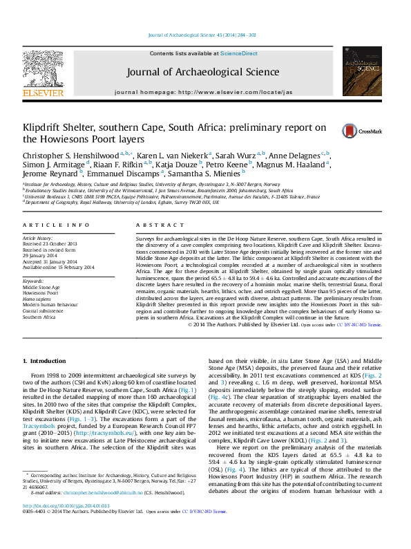
 Jerome Reynard