Mediterranean Archaeology and Archaeometry, Vol. 18, No 4, (2018), pp. 477-484
Copyright © 2018 MAA
Open Access. Printed in Greece. All rights reserved.
DOI: 10.5281/zenodo.1477964
THE REAPPEARING SUN IN NEOLITHIC ORCADIAN
LANDSCAPE AND CULTURE
Victor Reijs
Independent citizen scientist
(victor.reijs@archaeocosmology.org)
Received: 28/02/2018
Accepted: 16/05/2018
ABSTRACT
This paper attempts to answer the question if the skyline phenomenon of the reappearing Sun can be seen
from several monuments as part of an Neolithic Orcadian culture? Several sites are evaluated.
Within Maeshowe (a chambered cairn) one can experience the Winter Solstice Sun, but also the reappearing
setting Sun some 20 days before/after Winter Solstice day behind Ward Hill and reappearing for a few
minutes at the right slope of Ward Hill. This phenomenon looks not to have been witnessed in historic past.
As this reappearing Sun is a phenomenon of the skyline (fore sight) due the steep slope of the two hills; it
can also be witnessed at other locations (back sights) on Orkney. Based on visual 4D computer simulations;
the Sun‟s reappearance has been recorded at Ness of Brodgar and Breckness settlements in 1999. At that time
Historic Environment Scotland was informed about the possible archaeological importance of the Ness of
Brodgar and Breckness. Chance artefacts and recent excavations at Ness of Brodgar show that there is indeed significant archaeology in the form of a large likely ceremonial centre.
Interviews were broadcasted in 1997, 2000 and 2012 by Radio Orkney and BBC Scotland to ask listeners/viewers for experiences around the reappearing Sun. This provided a link to a contemporary sighting of
light reflections on Ward Hill.
Several interpretations of the landscape with its built environment are provided: from the possible conscious
perception of the reappearing Sun; through a symbolic link with the possibly sacred Hoy hills; to the incorporation of such foci into humanised space that links sky, land and humans with an annual rhythm: a possible pilgrim route.
KEYWORDS: Visual 4D simulation, Orkney, Hoy, Neolithic monuments, Archeaoastronomy, Maeshowe,
Ness of Brodgar, Breckness
�478
V. REIJS
1. INTRODUCTION
2. OBSERVING THE LANDSCAPE
This paper presents an overview of horizon phenomena relating to the reappearing Sun from several
monuments part of Neolithic Orcadian culture in
Scotland. A well-known monument on the Mainland
in Orkney is Maeshowe, a chambered cairn dating
from between 3100 to 2700 BCE (Ashmore, 1989). It
is commonly known that the Sun gets into
Maeshowe‟s chamber around Winter Solstice (WS),
but there is more to experience inside that chamber.
Well before and after the present-day Winter Solstice
(some 20 days) the Sun sets and then reappears from
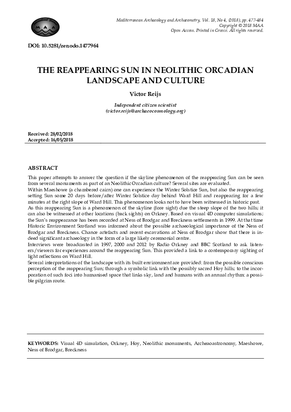
behind Ward Hill, a hill on the island of Hoy (Figure
1). Witnessing this phenomenon in 1998 for the first
time in historic times (no documentation has been
found that mentions this), was a very exciting and
unforgettable event.
This section will cover observations and recordings perfomed during visits to Orkney.
Figure 1 Skyline seen from Maeshowe, Orkney.
To an observer standing in front of Maeshowe;
some 41 days before/after present day WS, the Sun
reappears from behind the right slope of Cuilags
(Kame of Hoy), before it finally sets. This reappearance can though not be witnessed from within
Maeshowe (Reijs, 2001).
As this reappearing Sun is due the steep slope of
the hills, aka a horizon phenomenon (fore sight), it
can also be witnessed at other locations on Orkney.
Based on computer simulations, the Ness of Brodgar
and Breckness were recorded in 1999 (Reijs, 2001).
The Sun‟s yearly play with the skyline has been
broadcasted (from December to February) over the
Internet from 1997 (Reijs, 1997; Tait, 2002).
1.1. Methodology
A selection of monuments (back sights), with reappearing Sun on different days, has been observed
with theodolite and recordings. To allow future
desktop evaluation of locations, computer based
skyline profiles have been benchmarked with theodolite measurements. Unstructured interviews were
held with landowners, observers and an astronomer.
Interviews were broadcasted on December 1997,
November 2000 and April 2012 by Radio Orkney to
ask listeners for experiences around the reappearing
or reflecting Sun. For cultural/anthropological interpretation, literature was studied.
2.1. Geography and geology of Orkney
Mainland, the biggest island of Orkney, is some 35
km north of mainland Scotland: ~59º North and ~3º
West. Mainland‟s geology consists of Middle Old
Red Sandstone flagstone, which provides good
building material. Hoy is an island south of Mainland, separated by Hoy Sound. The Hoy hills are
relatively high, barren, wet and they consist of Hoy
sandstone, which is Upper Old Red Sandstone
(Davidson and Henshall, 1989).
2.2. Earlier research
A 4D (3D plus time) computer model of
Maeshowe‟s passage, chamber, landscape and skyscape was constructed (Reijs, 1996, 1998). This provided the visual proof that, beside the broad WS
Sun, the Sun light reappears within the chamber for
about one minute, when the Sun reappears from behind Ward Hill about 20 days before and after WS.
This was recorded on December 1st, 1998. The main
reason why this was not witnessed in the past, is that
the reappearing happens some 10 minutes after the
usual Sun light has disappeared and people would
have left by then the chamber (Reijs, 1999a).
In 1997 MacKie (1997) described also Maeshowe‟s
broad WS Sun setting, and a reappearing Sun
around 23 and 45 days before/after WS 2700 BCE.
MacKie relates these events to Alexander Thom‟s
Megalithic Month (Thom, 1967), which are 22 to 24
days long. MacKie did though not recognise that the
reappearing Sun light can be seen within
Maeshowe‟s chamber.
If Maeshowe was located with such a horizon
phenomenon in mind, there might be a chance that
other monuments on Orkney were also related to
such reappearances. Furthermore Ward Hill‟s and
Kame of Hoy‟s steep slopes can be seen from many
Neolithic monuments (Reijs, 1999b). The many
chambered cairns on Orkney might have been
placed at the boundary of visibility/non-visibility of
the summits of Ward Hill and the Cuilags (Reijs,
2012).
The reappearing Sun would have occured near
WS 3000 BCE at Ness of Brodgar from behind Ward
Hill) and at Breckness from behind Kame of Hoy)
(Reijs, 2001). This reappearing can be witnessed over
a distance of several hundred meters centred around
Brodgar Farm, due to the relative small distance of
the hills. In 1999 this was communicated to Historic
Environment Scotland and the local archaeologist
was asked if there was significant archaeology pre-
Mediterranean Archaeology and Archaeometry, Vol. 18, No 4, (2018), pp. 477-484
�THE REAPPEARING SUN IN NEOLITHIC ORCADIAN LANSCAPE AND CULTURE
sent at these locations, which could indicate a ceremonial environment. According to their knowledge
and the then Canmore database: no significant archaeology was known.
In 2002 a geophysical survey was done at the Ness
of Brodgar and when a notched stone was ploughed
up, an excavation was performed in 2003 (Ballin
Smith, 2003). Considerable archaeology, in the form
of a large likely ceremonial centre, was found and
further excavations were done from 2004 and are
still continuing (Card, 2017). No recent archaeological work has been done at Breckness, although the
author has found considerable evidence of archaeological remains while walking ploughed fields in
2012.
2.3. Tools to determine skyline profile
2.3.1.
Theodolite skyline profiling
Skyline altitude (in this paper „altitude‟ is equivalent to „apparent altitude‟, so including refraction
and parallax) were based on theodolite measurements. A workflow was designed to evaluate the
measurements through: computation of Sun/Moon
azimuth altitude and their semi diameters; compensation of altitude scale; precision/accuracy analysis;
and graphing to sanity check measurements
(Ghilani, 2004; Reijs, 2006).
Some results from the theodolite measurements:
From Maeshowe the right slopes of Ward Hill
and Cuilags cause a reappearing Sun several
days before WS day. Around its construction
time (~2900 BCE) the reappearance would be
respectively ~26 and ~45 days from WS.
Standing (around 3150 BCE) at the north-west
of the Ness of Brodgar‟s lesser wall, the Sun
would reappear from behind the right slope
of Ward Hill some 5 days before/after WS.
The reappearing Sun around 3150 BCE would
happen at WS more or less at the Brodgar
Farm location.
As Breckness is close to the Cuilags‟ right
slope (around 5km), a large area will experience a reappearing WS Sun over many epochs
(Reijs, 2001).
2.3.2.
Computer generated skyline profiling
Two computer skyline profiling services were
evaluated: standalone software by Fernando Patat
(2011); and the Web Service called HeyWhatsThat
from Michael Kosowsky (2012). All use height-data
gathered during the Shuttle Radar Topography Mission (SRTM). For American locations the height is
averaged over 30 m (SRTM30) and for the rest of the
world it is averaged over 90 m (SRTM90), with an
average-height precision of 2 to 8 m. In environ-
479
ments with steep hills, the accuracy of the averageheight compared to the actual height can be lower
and some STRM data can be missing if the surface
was in the radar‟s shadow. The CGIAR initiative
(CGIAR-CSI, 2017) has tried to eliminate most of the
SRTM data limitations (but not all, see below).
Patat‟s software use CGIAR and HeyWhatsThat uses
raw SRTM. The skyline profile can be off due to limitations of SRTM data. This has been checked with
photometric surveys, and no significant errors were
seen.
2.3.3.
Evaluation of tools
Comparing Maeshowe‟s skyline points measured
by MacKie with author‟s measurements gives average difference for azimuth ~0.03º and for altitude
~0.003º. Including the theodolite‟s standard deviation this gives and overall standard deviation for
azimuth ~0.03º and for altitude ~0.004º. This translates into a declination‟s standard deviation σdecl
~0.01º (in this paper „declination‟ is equivalent to
„topocentric declination‟, aka including parallax and
excluding refraction).
By comparison: measurements with a compass/clinometer would have an accuracy of around:
σazi ~1º and σalt ~0.25º.
The computer based skyline profiles have a σazi
~0.8º/distance and σalt ~0.15º/distance (distance in
[km]) (Patat, 2011). In the Orcadian environment
(around 5km horizon distance): the σazi ~0.15º and
σalt ~0.03º. Computer based skyline profiles are in
most instances more accurate than compass/clinometers, but checking at the monument
(ground-truthing) is essential (Ruggles, 1999), as
computer generated skyline profiles can have severe
limitations!
2.4. Interaction between landscape and
skyscape
The phenomena in Orkney happen somewhere on
the horizon (the fore sight) and the phenomenon can
be seen (best) from a certain position in the landscape (the back sight).
As the steepness of the Hoy hills is larger than the
set angle of the Sun‟s path, reappearing can happen.
The approximate rise/set angle of the Sun‟s path is
(North, 1996):
Angle = arcos(sin(latitude) *cos(declination))
At the solstices, this rise/set angle would be ~20º
in Orkney. The natural angle of repose for most
granular natural material (sand, gravel, clay, etc.) is
between 30º and 40º (Lowrie, 2002), so naturally settled hills of such material can results in a reappear-
Mediterranean Archaeology and Archaeometry, Vol. 18, No 4, (2018), pp. 477-484
�480
V. REIJS
ing Sun. Solid rock formations can of course have
any slope angle.
Another observed phenomenon that could strengthen the importance of the Hoy Hills, is the reflection
of Sun light.: Sir W. Scott (Scott, 1871; Harte, 1999)
quotes from Dr. Wallace‟s description (1700 CE) that
the Sun around summer months might reflect on
Ward Hill‟s wet surface. A 2001 Radio Orkney interview resulted in finding someone who witnessed the
Sun reflections from Bu on Hoy in 1990s.
3. CULTURAL INTERPRETATIONS
Beside the possible alignments at Orcadian Neolithic monuments, both Keith Kintigh (2008) and
Brad Schaefer (2004) mention that it is important to
investigate the possible anthropological/cultural
interpretations of such possible alignments. This section will examine a few possible interpretations.
Thomas (2002) points out the existence of a multitude of readings of the landscape during Neolithic
times itself: “... as with any symbolic system, the essentially arbitrary nature of this way of attributing
meaning to place meant that an endless series of alternative readings was always possible”.
And these readings can be seen in the different archaeological layers found at the Ness of Brodgar,
Maeshowe and many other places (Richards, 1991).
According to David Williams-Lewis & David Pearce
(2009), a tension is present between one form of
cosmology “which arises „spiritually‟ from within
human beings ... and another that derives from people‟s observations of what they see and measure.”
In the case of ethnography (where we still can interact with the people) the difference of interpretation between the findings and the initial assumptions of the analyst is called alterity. And according
to Martin Holbraad (Holbraad, 2007); the greater the
level of alterity the more the analysts have to theorise. For pre-historic studies ethnography is not really possible, so it is likely to have a range of possible
interpretations of the Neolithic readings of the landscape.
Amiria Henare (Henare, Holbraad, and Wastell,
2007) reasons that a „thing‟ and its „meaning‟ can be
experienced the same: “things might be treated as
sui generis meanings”. So keep in mind that „things‟
could be “encountered in the field as they present
themselves, rather immediately assuming that they
signify, represent, or stand for something else.” So,
for instance „Thunder is the god Thor‟ and thus not
stating that the thunder represents the Thor and also
not analysing thunder and Thor on their own.
Below several cultural interpretations around the
reappearing phenomena will be investigated, while
the last three interpretations might be more speculative.
3.1. Perception of reappearing Sun
A natural phenomenon (like Sun appearing at a
slope) just happens, regardless if a human perceives
it or not. It is important to recognise that perception
happens at least at two levels: unconsciously and
consciously. The difference between the two is that
for a human his/her attention has to be captured for
a conscious perception of the phenomenon. As soon
as one‟s attention is captured to e.g. the reappearing
Sun, it almost looks so obvious; but it needs this essential attention. Arien Mack and Irvin Rock (2000)
found that without this explicit attention a human
does not perceive consciously a phenomenon. Mack
and Rock (2000) found that they could increase the
likelihood that a phenomenon gets attention, by positioning it relative to a spatial focus of attention.
Such a spatial focus can be a human or natural
construction (aka back sight) as long as the focus in
the landscape could be pointed out (also with attention) to others. If that spatial focus is not recorded in
some way (verbally, written, rock art or construction), it will be very difficult to get proof beyond reasonable doubt that the phenomenon or not-pointedout focus was consciously perceived/used (Schaefer,
2004). So, there is always a chance that the phenomenon has not been perceived, even though it looks at
present days to be an (obvious) conscious perception.
The reappearing Sun could also have been experienced as an entity (thing/being) from another realm
of existence and that such entity could interact with
people in the material world. Shifts/alternations in
the human consciousness can stimulate such experiences, according to Lewis-WiIliams and Pearce
(2009).
3.2. Symbolic importance of Hoy hills
Tilley describes the likely deliberate spatial organisation of monuments around the Swedish‟s Ǻlleberg mountain, which is enveloped in a wealth of
mythology (Tilley, 1993). A similar spatial organisation might have taken place on Orkney (Reijs, 2012).
Furthermore the type of sand stone on Hoy is different from the Mainland‟s: On the Mainland the sandstone can be split easily in flags (so good building
material) (Davidson and Henshall, 1989). No Hoy
sandstone was found in Mainland monuments
(Richards, 2013). Beside the reappearing phenomenon that relates to the right slopes of the Hoy hills,
there is also the midsummer phenomenon of the reflecting Sun on Ward Hill‟s wet surface (Scott, 1871).
These different phenomena could provide an environment to perceive these Hoy hills as sacred.
A story reported by Sigurd Towrie (Anonymous,
2000) could be related to reappearing Sun rays between Hoy and Breckness region: “When the preach-
Mediterranean Archaeology and Archaeometry, Vol. 18, No 4, (2018), pp. 477-484
�THE REAPPEARING SUN IN NEOLITHIC ORCADIAN LANSCAPE AND CULTURE
ing of Christianity became too much for the
trows/fairies, they decided to abandon the Mainland
and head out to Hoy. To do this, they strung a straw
rope from the Black Craig (2km North of Breckness)
to Ward Hill of Hoy and began to climb across. Unfortunately, however, the rope snapped and they fell
to their deaths. The one trow who was waiting for
them on Ward Hill, upon seeing the others die,
howled in anguish before casting himself into the
sea”.
So, as discussed by Anthony Aveni (Aveni, 2008),
a symbolic link between periphery (Hoy hills) and
centre (Mainland monuments) might be present.
3.3. Megalithic Calendar
Thom proposed the Megalithic Calendar, where
the year is divided in 16 months of 22 to 24 days
(Thom, 1967). The distribution of the calendar
months was derived from Thom‟s measurements,
assuming building epoch of 1800 BCE. Thom‟s Megalithic Calendar is not generally accepted in archaeoastronomy (Ruggles and Barclay, 2000). Calendars
are reported to be linked to the skyline, such as for
the Pueblos of Southwest USA (Zeilik, 1985). This
could also be the case for the Hoy hills. Sun rise/set
skyline locations could also indicate a date that anticipates the upcoming event (Zeilik, 1985); the problem with an anticipatory date is that one can designate any upcoming event, if there are no historic
records.
For Maeshowe at 2900 BCE, the right slope of
Ward Hill (δ = -21.631º) is ~26 days from WS and the
right slope of Kame of Hoy (δ = -17.066º) is ~45 days
from WS. Thom‟s Megalithic Calendar transposed to
2900 BCE would give: Megalithic Month11/13 ~24
days and Megalithic Month10/14 ~46 days from WS.
So, these periods are comparable. At the Ness of
Brodgar or Breckness the Megalithic Months certainly don‟t match up like at Maeshowe.
3.4. A priest-elite in British Isles
The existence of a possible priest-elite in megalithic Britain is a topic of some controversy between
MacKie and Ruggles (Ruggles and Barclay, 2000).
Thom started this idea by stating that his Megalithic
Yard and Calendar were expected to be managed
centrally in the British Isles (Thom, 1967).
If such an elite was present in Neolithic times, is
not for sure. The supporting argument of Mackie is
that large settlements like: the Ness of Brodgar;
Barnhouse; and Skara Brae are labelled by archaeologist as ceremonial as they don‟t have much domestic artefacts. Mackie‟s standpoint is that full-time
professionals are needed to generate and protect
knowledge and these groups utilised learning cen-
481
tres, which were stocked/supported by lay people
(Towrie, 2012).
In other cultures such elites might have existed.
There are recorded examples in the Pueblos of
Southwest USA) where astronomical observations
could be corrected by other people (Zeilik, 1985). In
Babylon vast amount of data was recorded and other
people were consulted to audit first lunar crescent
observations (Stern, 2008). And according to Klaus
Schmidt; Göbekli Tepe could have been a ritual centre for religious purpose (Lewis-Williams and Pearce,
2009).
3.5. Human interaction with Orcadian
landscape
Tilley (1994) states that one can‟t see the landscape
as just something natural and opposed to people, but
better to see the landscape as totally socialised.
Landscape becomes intricately embedded in society:
“Humanised places become fashioned out of landscape through the recognition of significant qualities
in that what has not in itself been culturally produced (rocks, rivers, trees, etc.) by association with
current use, past social actions or actions of a mythological character.”
As Thomas (2002) states, if humans construct
monuments at their place, these monuments are
“thoroughly bound up with human existence and
we should be able to interpret them in social terms.”
Such monument (a spatial focus) could have been
built to mark a specific phenomenon. This phenomenon can now be seen in social terms, as the building
of this spatial focus changed the way the place is or
will be experienced.
This links with Tilley‟s ideas that rhythms of
land/sky will be part of the rhythms of
lives/societies: “A fundamental part of daily experiences in non-industrial societies is the physical and
biological experience of landscape – earth, water,
wood, stone, high places and low places, the wind,
rain, sun, stars and sky. The rhythms of the land and
the seasons correspond to and are worked into the
rhythms of life.” The Neolithic monuments in the
Mainland‟s landscape can have such linkage with
the rhythms of the sky as several seem to have
alignments with celestial events.
Enclosures, walls, platforms, doorways, passages
and inner chambers regulated the way people can
have access to these places (Thomas, 2002; Stout,
2010). When the Ness of Brodgar settlement got a
stone (lesser) wall after 3150 BCE, would there have
been a platform at each of the entrances to observe
the reappearing Sun? No excavations have yet been
performed near these entrances.
Mediterranean Archaeology and Archaeometry, Vol. 18, No 4, (2018), pp. 477-484
�482
V. REIJS
3.6. Mortuary practices
4. CONCLUSIONS
According to Hedges, the individual‟s body was
first excarnated outdoors and at some moment, perhaps annually, the bones were placed, possible with
a public ceremony, into a chambered cairn like Isbister, Mainland Orkney (Hedges, 1984). So the dead
keep being important for the living, as they are given
a new resting place inside their own territory.
Thomas (2002) states the change from individual
to ancestor, comparable to Hedges reasons: “... bones
were considered and treated as being representative
of a person, someone who was remembered by those
that lived after. In time, however, their identity will
have been forgotten – they will have simply become
one of the ancestors.” (Hedges, 1984). Hedges also
references to a possible annual event to place the
excarnated bones inside a chambered cairn. This
could have happened at reappearing Sun: when that
phenomenon happens, it signalled the (re)burial of
the ancestors.
This research project has looked at several aspects
of the reappearing Sun in Neolithic Orcadian culture.
First of all the skyline profiles were measured
more accurate/precise with a theodolite. Computer
based skyline profiles have been checked against
these theodolite measurements and were found to be
more accurate/precise than compass/clinometers
readings; but one always has to verify by groundtruthing, certainly for nearby skylines.
The phenomenon of a reappearing Sun (Figure 2)
behind a slope that is steeper than the Sun‟s path has
been analysed for a few Orcadian monuments/settlements (Maeshowe, Ness of Brodgar and
Breckness) and this showed that reappearing does
not always happen on specific celestial events (like
equinox/standstill), but regardless of that; it happens. This reappearing could have been seen as a
special phenomenon or entity/thing.
The reappearing phenomenon can be witnessed at
many places in the Orcadian landscape and Neolithic monuments are (still) unearthed at many places.
So what makes a Neolithic monument a human spatial focus for a reappearing phenomenon?
Several interpretations of the landscape with its
built environment have been provided, from the
possible conscious perception of the reappearing
Sun and a symbolic link with the possibly sacred
Hoy hills, through incorporating such foci into humanised space that links sky, land and humans with
an annual rhythm. The journeys between the foci can
be just as important as the foci themselves and these
journeys might have been indicated by certain
pointers included in the foci.
The reburial of ancestors‟ excarnated bones could
be regulated by annual events and a (horizon) calendar could have been used to synchronise the different societies/tribes on Orkney. If this calendar was a
formal calendar managed by a priest-elite, is not
known, but non-utilitarian settlements could point to
a class society.
This research leaves a lot of questions unanswered
and new questions are added. Such as: Were there
platforms near the (lesser) walls at the Ness of
Brodgar?; Are there artefacts linking the monument
to the reappearing phenomena?; Did humans made
spatial foci at Breckness (even though the horizon is
so near)?; etc.
So on the journey of understanding Neolithic Orcadian culture, another small step has been placed. I
am sure more steps will be placed.
3.7. Pilgrimage routes in Orcadian landscape
The Mainland landscape can be described as special/sacred as it is “a massive ceremonial complex,
fragments of which are only now coming to light”
(Richards, 1991). In such an environment pilgrimages could have happened. Peter Jan Margry (Margry,
2008) gives a definition of pilgrimage: “... a journey
based on religious or spiritual inspiration, undertaken by individuals or groups, to a place that is regarded as more sacred or salutary than the environment of everyday life, to seek a transcendental encounter with a specific cult object for purpose of acquiring spiritual, emotional or physical healing or
benefit.”
It is likely that pilgrimage routes existed between
the major monuments in this area as there exist directions from: Standing Stones of Stenness towards
Barnhouse Structure 8; and Ness of Brodgar‟s Structure 10 towards Maeshowe area. The precise dates of
all these monuments are not known, but one could
see the Standing Stones of Maeshowe contemporary
with the Standing Stones of Stenness and Barnhouse
Structure 8 but earlier than the Ness of Brodgar‟s
Structure 10. These monuments could serve as „stations‟ in the landscape for people‟s movement
(Thomas, 2002). No evidence has been found or excavated.
Mediterranean Archaeology and Archaeometry, Vol. 18, No 4, (2018), pp. 477-484
�THE REAPPEARING SUN IN NEOLITHIC ORCADIAN LANSCAPE AND CULTURE
483
Figure 2 Reappearing Sun behind Ward Hill on December 21st 1999 seen from Ness of Brodgar.
ACKNOWLEDGEMENTS
I want to thank everyone, and in particular: staff of Historic Environment Scotland, Joke Jansman, Doug
Schwartz and Charles Tait, who all helped me with informing, producing and reviewing this paper. I also
want to thank the reviewers for their constructive contributions. Any remaining errors in methodology or
results are my responsibility of course.
REFERENCES
Anonymous. (2000) The death of the mainland trows. Orkneyjar.com, In
http://www.orkneyjar.com/folklore/trows/trowdeath.htm [accessed 15 September 2017].
Ashmore, P. (1989) Maes Howe. Edinburgh, Howie&Seath.
Aveni, A. (2008) The role of astronomical orientation in the delineation of world view: A center and
periphery model. In A. Aveni (ed.), Foundations of new world cultural astronomy: A reader with
commentary. pp. 253–272. Boulder, University Press of Colorado.
Ballin Smith, B. (2003) A new late Neolithic house at Brodgar Farm, Stenness, Orkney. Glasgow, GUARD.
Card, N. (2017) Excavation background. Ness of Brodgar trust, In https://www.nessofbrodgar.co.uk/the–
discovery/ [accessed 5 Februari 2018].
CGIAR–CSI. (2017) SRTM 90m Digital Elevation Data. The CGIAR consoritum for spatial information, In
http://srtm.csi.cgiar.org/ [accessed 5 Februari 2018].
Davidson, J. L., and A. S. Henshall. (1989) The chambered cairns of Orkney: an inventory of the structures and their
contents. Edinburgh University Press.
Ghilani, C. D. (2004) Astronomical observation handbook. (The Pennsylvania State University). In
https://www.scribd.com/document/192238972/Astronomical–Observations–Handbook–Charles–D–Ghilani
[accessed 30 June 2017].
Harte, J. (1999) The enchanted carbuncle of the northern hills. 3rd stone, Vol. 33, p 35.
Hedges, J. W. (1984) Tomb of the eagles: A window on stone age tribal Britain. Oxford, Tempvs Reparatvm.
Henare, A. J. M., M. Holbraad and S. Wastell. (2007) Thinking through things: Theorising artefacts
ethnographically. Routledge.
Holbraad, M. (2007) The power of powder: Multiplicity and motion in the divinatory cosmology of Cuban
Ifa. In Amaria Henare, Martin Holbraad and Sari Wastel (eds.), Thinking through things; Theorising
artefacts ethnographically. pp. 189–225. Abingdon, Routlege.
Kintigh, K. W. (2008) I wasn't going to say anything, but since you asked. In A. Aveni (ed.), Foundations of
new world cultural astronomy: A reader with commentary. pp. 803–805. Boulder, University Press of
Colorado.
Kosowsky, M. (2012) HeyWhatsThat. In http://www.heywhatsthat.com/ [accessed 10 March 2012].
Lewis–Williams, D., and D. Pearce. (2009) Inside the Neolithic mind: Consciousness, cosmos and the realm of the
gods. Thames & Hudson.
Lowrie, R. L. (2002) SME Mining reference handbook. Society for mining, metallurgy, and exploration.
Mack, A., and I. Rock. (2000) Inattentional blindness. The MIT Press.
MacKie, E. W. (1997) Maeshowe and the winter solstice ceremonial aspects of the Orkney grooved ware
culture. Antiquity, Vol. 71, pp. 338–359.
Mediterranean Archaeology and Archaeometry, Vol. 18, No 4, (2018), pp. 477-484
�484
V. REIJS
Margry, P. J. (2008) Secular pilgrimage: A contradiction in terms? In Peter Jan Margry (ed.), Shrines and
pilgrimage in the modern world: New itineraries into the sacred. pp. 13–48. Amsterdam University Press.
North, J. D. (1996) Stonehenge: Neolithic man and the cosmos. London, HarperCollins.
Patat, F. (2011) Horizon synthesis for archaeo–astronomical purposes. Astronomische Nachrichten, Vol. 332,
pp. 743–749.
Reijs, V. M. M. (1996) Maeshowe. In http://www.archaeocosmology.org/maeshowe/eng/scot10.htm [accessed 30
June 2012].
Reijs, V. M. M. (1997) Geniet: Research on Maeshowe, Orkney, UK. In
http://www.archaeocosmology.org/maeshowe/ [accessed 8 February 2018].
Reijs, V. M. M. (1998) Maeshowe's Megalithic Month alignment. 3rd stone, pp. 18–20.
Reijs, V. M. M. (1999a) Reappearing sun light in Maeshowe, Orkney. YouTube. In
http://www.youtube.com/watch?v=Wsp2LAE12ho.
Reijs, V. M. M. (1999b) Views towards Ward Hill and Cuilags, Orkney. In
http://www.archaeocosmology.org/maeshowe/eng/horizons.htm [accessed 4 March 2012].
Reijs, V. M. M. (2001) The reappearing sun at Orkney. In
http://www.archaeocosmology.org/maeshowe/eng/flashing.htm [accessed 4 March 2012].
Reijs, V. M. M. (2006) ARCHAEOCOSMO. In http://www.archaeocosmology.org/eng/archaeocosmoprocedures.htm
[accessed 5 July 2012].
Reijs, V. M. M. (2012) The reappearing Sun in Neolithic Orcadian culture. In
http://www.archaeocosmology.org/eng/VictorReijs–ReappearingSun–014–web.pdf [accessed 15 October
2012].
Richards, C. (1991) Maeshowe 1991 Phase 3 structures report. University of Glasgow.
Richards, C. (2013) Building the great stone circles of the North. Windgather Press.
Ruggles, C. L. N. (1999) Astronomy in prehistoric Britain and Ireland. London, Yale University.
Ruggles, C. L. N., and G. Barclay. (2000) Cosmology, calendars and society in Neolithic Orkney: a rejoinder
to Euan MacKie. Antiquity, Vol. 74, pp. 62–74.
Schaefer, B. E. (2004) Case studies of three of the most famous claimed archaeoastronomical alignments in
North America. in Oxford VII. Flagstaff Az.
Scott, W. (1871) The pirate. Edinburgh, A. & C. Black.
Stern, S. (2008) The Babylonian month and the new moon: sighting and prediction. Journal for the History of
Astronomy, Vol. 39, pp. 19–42.
Stout, G. (2010) Monumentality and inclusion in the Boyne Valley, County Meath, Ireland. In T. Darvill, J.
Leary and D. Field (eds.), Round Mounds and Monumentality in the British Neolithic and Beyond. pp.
197–210. Oxbow Books.
Tait, C. (2002) Maeshowe Winter solstice Sunset. In http://www.maeshowe.co.uk/ [accessed 5 December 2017].
Thom, A. (1967) Megalithic sites in Britain. Oxford, Oxford University Press.
Thomas, J. (2002) Understanding the Neolithic. London, Routledge.
Tilley, C. (1993) Art, architecture, landscape: Neolithic Sweden. In B. Bender (ed.), Landscape: Politics and
perspective. pp. 49–84. Oxford, Berg Publishers.
Tilley, C. (1994) A phenomenology of landscape: places, paths and monuments. Oxford, Berg Publishers.
Towrie, S. (2012) Resurrecting the Neolithic priesthood… Interview with MacKie. In
https://web.archive.org/web/20171012072730/http://www.orkneyjar.com/archaeology/2012/01/10/resurrecti
ng–orkneys–neolithic–priesthood/ [accessed 12 October 2017].
Zeilik, M. (1985) The ethnoastronomy of the historic Pueblos, I: Calendrical Sun watching. Archaeoastronomy,
Vol. xvi, pp. S1–S24.
Mediterranean Archaeology and Archaeometry, Vol. 18, No 4, (2018), pp. 477-484
�
 Victor Reijs