CHINESE GEOGRAPHICAL SCIENCE
Volume I 1, Number 4, pp. 366 - 376, 2001
Science Press, Beijing, China
A STUDY ON LANDSCAPE MOSAIC STRUCTURE
IN URBAN-RURAL AREA IN NORTHWEST
OF CHINA WITH RS AND GIS
-A Case Study of Xigu District in Lanzhou City
XU Jian-hua 1, LU Yan 1, AI Nan-shan 2, YUE Wen-ze 3
(1. Department of Geography, East China Normal University, Shanghai 200062, P. R. China;
2. Environmental Science and Engineering School, Sichuan University, Chengdu 610064, P.R. China;
3. Department of Geography, Lanzhou University, Lanzhou 730000, P. R. China)
ABSTRACT: At the study area of Xigu District in Lanzhou City, using RS & GIS as tools we apply Diversity, Domi-
nance, Fragmentation, Isolation and so on to study the quantitative, fractal and spatial characters of landscapes" structures in the four sub-regions divided by the morphological features. Using the Fractal Theory to establish the fractal structure models, we analyze the complexity and stability of various landscapes" distribution with fractal dimension value.
The spatial distribution characteristics of landscape mosaic structure are also expounded. At the end of the paper we discuss the relevant problems on the main factors which control and effect on the spatial pattern of landscapes as well as on
landscape optimization and management.
KEY WORDS: landscape mosaic; spatial structure; fractal; Xigu District in Lanzhou City
CLC number: P901; Q149
1
REGIONAL BACKGROUND
Documentcode: A
AND
RESEARCH
Article ID: 1002-0063(2001)04-0366-11
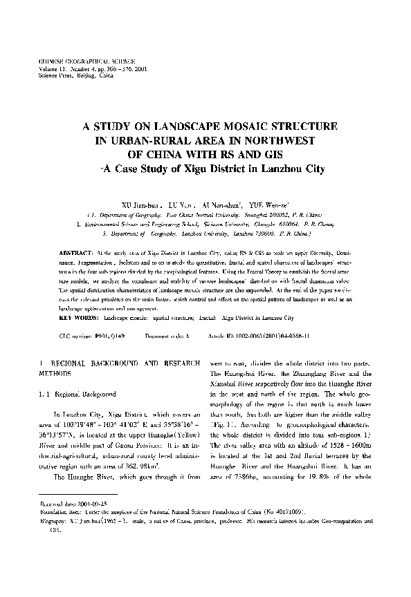
west to east, divides the whole district into two parts.
The Huangshui River, the Zhuanglang River and the
METHODS
Xianshui River respectively flow into the Huanghe River
1.1
Regional Background
in the west and north of the region. The whole geomorphology of the region is that north is much lower
In Lanzhou City, Xigu District, which covers an
than south, but both are higher than the middle valley
area of 103019'48 " - 103 ° 4 1 ' 0 2 " E and 35°38'16 " -
(Fig. 1). According
36°13'57"N, is located at the upper Huanghe(Yellow)
the whole district is divided into four sub-regions. 1)
River and middle part of Gansu Province. It is an in-
The river valley area with an altitude of 1528 - 1600m
dustrial-agricultural,
is located at the 1st and 2nd fluvial terraces by the
urban-rural county level adminis-
trative region with an area of 3 6 2 . 9 8 k m 2.
The Huanghe River, which goes through it from
Huanghe
to geomorphological characters,
River and the Huangshui River.
area of 7386ha,
It has an
accounting for 19. 8% of the whole
Received date: 2001-09-25
Foundation item: Under the auspices of the National Natural Science Foundation of China (No. 40171069).
Biography: XU Jian-hua( 1965 - ), male, a native of Gansu province, professor. His research interest includes Geo-computation and
GIS.
�A Study on Landscape Mosaic Structure in Urban-Rural Area in Northwest of China With RS and GIS
367
district, and it is also the center of regional economy,
east mountainous area to 291mm in the northwest
society and culture. 2) The terrace & gentle slope area,
mountainous area.
located at the 4th and 5th terraces of two banks of the
Huanghe River, with an area of 4401ha, which ac-
1.2 Data and Research Method
counts for 11.8% of the whole district, is mainly composed of eight terraces with an altitude of 1607 - 1800m
All the data needed include 1) 1:8000 aerial re-
and a slope of less than 10 °, namely Dajia terrace,
mote sensing image data(1998), 2) 1:50 000 TM im-
Zhangjia terrace, Qingshi terrace, Zhama terrace, Li-
age data(2000), 3) 1:10 000 relief map(1998), 4)
ugou
other data including climate, hydrology, vegetation,
terrace,
Fanjia
terrace,
Zhangjia
terrace,
Guangjia terrace, etc. 3) The southern mountainous
soil and so on.
area is located above the southern terraces, with an al-
The research method consists of six major steps: 1)
titude of 1800 - 2621.4m and an area of 9588ha, ac-
use 1 : 5 0 000TM image to interpret and classify the
counting for 25.6%
landscapes, 2 ) s e l e c t 1:8000
of the whole district.
4) The
aerial remote sensing
northern mountainous area is located above the northern
image and 1:10 000 relief map to make a survey of land
terraces of the Huanghe River, with an altitude of
cover/land use and landscape patches, 3) digitize im-
1600- 2064. 6m and an area of 16 001ha, accounting
ages and relief map data( remote sensing image, relief
for 42.8% of the whole district.
map, survey data and so on), 4) integrate data into a
GIS system by image calibration, registration and data
processing for building spatial and attribute databases,
5) apply the quantitative methods to the quantitative
characteristics of the landscape mosaic structure and
fractal theory to fractal characteristics of the distribution
pattern of various landscapes, 6) with spatial analytical
methods of GIS(DENESH, 1995), study the main factors which control and influence the spatial pattern of
landscapes. Various methods and techniques used in
this study are briefly described in Fig. 2.
2
LANDSCAPE
MOSAIC
AND
QUANTITATIVE
CHARACTERISTICS
In a region, various landscape patches integrate
systematically into a landscape mosaic (FORMAN et al.,
1986), which shows spatial pattern of landscapes and is
Fig. 1 The digital elevation model of Xigu District
the result of the natural factors and human activities.
in LanzhouCity
Xigu District is typically continental and semi-arid
Some scholars think that the essence of landscape ecology is to study the landscape mosaic structure in that
climate and has obvious vertical climate change. Aver-
landscapes
age daily temperature difference and annual average
1995; XIAO, 1991).
temperature are respectively 13.6~C and 8.5°C,
are
diverse
mosaic
entities(FORMAN,
ex-
treme high temperature 39.7~C and extreme lower tem-
2. 1 Landscape Types and Mosaic Map
perature - 23.4°C. And the change rate of rainfall and
distinct spatial discrepancy are much larger. Annual
By TM interpretation we classify the landscapes
rainfall gradually decreases from 500ram in the south-
into ten kinds of landscapes, which are respectively
�368
XU Jian-hua, LU Yan, AI Nan-shah et al.
Relief map (1:10000)
]
I Acrialremoteseosingimage,,:8ooo, ]
I
I
[
ClassiJ} landscape types
[
l'iVl image I 1:50000 )
I
]
i
I
Interpretation [
I
[
I
]
I
Land use/co~ er surve~
[
I
Digitization
[
[
I
Image calibration, registration and ~ector/raster exchange
I
i
I
D
I
Overlay
Database management
I
I
Spatial structure of landscape mosaic
}
I
I
I Quantilati~ e analytical
method
[ Fractal model
I
Quantitative characteristic
of landscape mosaic
[
I
Fractal characteristic
of landscape mosaic
Fig. 2 Research methods and techniques
bare land, water area, urban area, rural settlement and
In order to show and analyze the spatial structure of
landscape mosaic, we made the landscape mosaic map
industrial area far from settlement. The special meaning
of Xigu District in Lanzhou City from the spatial and
of each landscape is listed in Table 1.
attribute databases of GIS, which is shown in Fig. 3.
farmland,
orchard,
woodland,
scattered woodland,
Table 1 Landscapetypes and remarks
Landscape types
Remarks
Farmland
Orchard
Grassland
Woodland
Covered by crops and vegetation
Including apple orchard, peach orchard, pear orchard, apricot orchard, etc.
Wasteland, pasture
Natural and artificial woodlands with canopy of trees larger than 30%
Scattered woodland
Woodland with canopy between 10% - 3 0 % of area and newly-made woodland with no canopy but viable rate
no less than 40% of reasonable tree numbers
Bare land
Land without vegetation coverage, including bare loess, rock and gravel
Water area
Urban area
Rural settlement
Industrial area far from settlement
Including river, creek, alluvial flat and pond
2. 2
Including satellite towns and the built-up area in the region planned by City Planning
Rural residential area
Including various factories and plants, which are far from settlement and not in the urban area
The Quantitative Characteristics of Landscape
Mosaic
to comprehensively quantify the landscape mosaic
structure.
1 ) Diversity, which is a general description of
2. 2. 1 General quantitative characteristics of landscape
mosaic
we can use diversity, dominance and fragmentation
abundance and balance of landscapes(TURNER et al.,
1991; ZHANG et al., 2000), is defined as follows:
�A Study on Landscape Mosaic Structure in Urban-Rural Area in Northwest of China With RS and GIS
369
N
w-E
$
Legend
Farmland ~ B a r e l a n d
Orchard
]
[ Water area
Grassland ~ U r b a n a r e a
_---~_._-'i~i~_Woodland ~
Rural settlement
~Scattered
~
Industrial area far
woodland r~'~'~','~from settlement
~
Fig. 3 Landscape mosaic map of Xigu District
$
i =
In formula (1),
3) Fragmentation is used to show the number of
(1)
H = - EP,InP,
patches in one unit area in the mosaic, and it is defined
1
S is the number of landscape types; Pi
as
follows:
S
is the area percent of landscape type i in the whole
mosaic; H is diversity index, which is much larger, the
more abundant landscapes
(3)
F = ~.~nja
k=
1
In formula (3), S is as same as that in formula ( 1 ) ; nk
2) Dominance is an indictor that shows what extent
is the patches' number of landscape type k; A is the
one or few landscapes dominate in mosaic structure,
whole area of all types of landscapes;
and it is defined as follows:
tion, which is much larger, the more patches are in a
S
n = InS + ~ P,lnP,
i =
F is fragmenta-
unit area.
(2)
We use formulas ( 1 ),
1
(2) and (3) to calculate
where D represents dominance, which is much larger,
diversity, dominance and fragmentation as the following
the more highly mosaic structure is dominated by one or
in Table 2.
few landscapes; S and Pi are as same as those in for-
Table 2 shows that diversity ranks in the four
sub-regions as river valley area(2. 0375)> terrace &
mula (1).
Table 2 Landscape diversity index, dominance and fragmentation in sub-regions
Area
River valley area
Terrace & gentle slope area
Southern mountainous area
Norhtern mountainous area
The whole district
Diversity (H)
2.0357
1. 8544
1. 3080
1. 2395
1. 827
Dominance(D)
0. 2669
0. 4482
0. 9987
1. 1584
0. 658
27. 4772
51. 4398
9. 4733
8. 3118
12. 147
Fragmentation(F)
(patehes/km 2)
�XU Jian-hua, LU Yah, AI Nan-shah et al.
370
gentle slope area(1. 8544) > southern mountainous area
and the patches with an area of lkm 2 are as many as
(1. 3080)> northern mountainous area(1. 2395),
above 51. 4398, and the fragmentation of the river val-
but
there is an adverse rank in terms of dominance, namely
ley area is much larger, 27.4772 patches with an area
northern mountainous area(1. 1584)>
southern moun-
of lkm 2. But in the south and northern mountainous
tainous area(0.9987)> terrace & gentle slope area
area the fragmentations are small, respectively 9. 4733
(0.4482)> river valley area (0.2669). Obviously in
and 8. 3118 patches with an area of lkm 2.
the river valley area various landscapes are distributed
2. 2. 2 Landscape isolation
equably without distinct dominant landscape types. But
Isolation shows that the distribution of different
in the southern mountainous area and northern moun-
patches that belong to the same type of landscape in the
tainous area they are distributed extremely unevenly and
there are obvious dominant landscapes. In the northern
landscape mosaic. It is defined as the follows(XIAO,
1991) :
mountainous area, the dominant landscape is grassland,
1 ni~-/AA_~k
which comprises of 85.96% of the whole area. In the
(4)
grassland and farmland, which respectively account for
where A is the isolation of landscape type k, nk and A
are as same as those in formula(3), Ak is the area of
60.93% and 28.51% of the whole area. And diversity
landscape type k.
southern mountainous area, the dominant landseapes are
and dominance in the terrace & gentle slope area are
For the same type landscape, isolation shows that
between those in the river valley area and those in the
what extent the landscape is cut and isolated by other
south and northern mountainous areas.
landscapes or corridors. That is, the larger the isolation
is, the more dispersedly the patches distribute.
Fragmentation represents what extent the land-
As for the four sub-regions in this region, we apply
scapes are cut by various corridors(creeks, roads and
etc. ). The larger fragmentation, the
more
formula(4) to figure out the isolation of various land-
strongly
scapes listed in Table 3.
landscapes are cut by corridors. Obviously the frag-
Table 3 shows that farmland is most densely dis-
mentation of terraee& gentle slope area is the largest
Table 3 Isolation of various landscapes in sub-regions
Area
Famland
Orchard
Grassland
Woodland
Scattered
woodland
Bare land
Water area
Urban area
Rural
Industrial area far
settlement from settlement
River
6. 1682
12. 3953
7. 942
51. 2730
36. 5440
11. 0947
3. 8840
O. 2244
13. 1183
5.9180
Terrace & gentle
slope area
6. 2548
8. 4266
7. 1522
44. 1453
23. 9741
29. 2099
-
10. 4207
12. 4217
17. 1712
Southern mountainous
area
9. 5215
28. 8777
3. 8371
9. 9431
14. 4415
38. 7253
-
21. 0350
-
Northern mountainous 13. 3231
area
21. 7048
1.4431
-
1. 3171
-
22. 8955
-
valley area
tributed in the river valley area and terrace & gentle
-
terrace & gentle slope area,
more densely in the
slope area, more densely in the southern mountains,
southern mountainous area, but it is distributed most
but in the northern mountainous area it is distributed
densely in the northern mountainous area. Woodland
more dispersedly. Orchard mostly is compactly dis-
(including woodland and scattered woodland) hardly
tributed in the terrace & gentle slope area, more com-
exists in the northern mountainous area and is sparsely
pactly in the river valley area, however it is distributed
distributed in the river valley area and level & gentle
more dispersedly in the south and northern mountainous
slope area, but most densely distributed in the southern
areas. Grassland is more sparsely distributed in the
mountainous area. Bare land is most densely distributed
�A Study on L a n d s c a p e Mosaic Structure in U r b a n - R u r a l A r e a in Northwest of C h i n a W i t h RS and GIS
371
in the northern mountainous area, more densely in the
river valley area, but more sparsely in the terrace &
below formula(DONG, 1991):
gentle slope area, most sparsely in the southern moun-
Taking n = 2, we get the fractal structure model in
tainous area. Urban area is mainly located at the river
valley area and level gentle slope area, more densely at
2-dimension Euclid space:
[P(r) ]1/o, = kr ~, -o,)/o,[a(r ) ~1/2
the river valley area, but more sparsely at the terrace &
where P ( r )
IS(r) ]~-T, = kr <n-I -o~.,>/oo ,[ V(r) ]-~
(6)
(7)
gentle slope area. Rural settlement is distributed in all
is circumference;
A ( r ) is area; k is
constant; D1 is fractal dimension in 2-dimension Euclid
the four sub-regions, most densely in the terrace &
space.
gentle slope area, more densely in the river valley area
As for a landscape patch, are its area and cir-
and more sparsely in the southern mountainous area, but
cumference suitable for the formula(7)? That is, has
most sparsely in the northern mountainous area. Indus-
landscape shape the fractal characteristic? Related re-
trial area far from settlements is mainly distributed in
search showed that any type landscape has the fractal
the river valley area and terrace & gentle slope area,
characteristics(BAI, 2000; XU et al., 2000).
more densely in the river valley area, but more sparsely
in the terrace & gentle slope area. All the water area is
Taking the formula(7) logarithmic transformation,
we obtain:
distributed in the river valley area.
ln[A(r) ] = D~ln[P(r) ] + C
3
THE FRACTAL CHARACTERISTICS OF LAND-
SCAPE MOSAIC
(8)
It is obvious that as long as we establish the regressive
model like formula(8) with the area and circumference
of the patch, we can get regressive coefficient 2/D1 and
Research findings show that landscape mosaic is
the most typically fractal entity in nature(BAI, 2000;
XU et hl., 2000), and various landscapes can be
quantified by the fractal theory. MANDELBROT(1982)
D1., where Dt represents the complexity and stability of
landscape type. The larger D~, the more complicated
the landscape type is. When D~ is equal to 1.50, the
landscape type is in the state of probability similar to
studied the structures of fractal entities and put forth a
Brown movement, which is in the most unstable state.
model:
The more closer D~ is to 1.5, the more unstable the
(5)
landscape type is(PEARCE,
r is
1995). According to the steps mentioned above, we
D is fractal dimension. DONG
establish the fractal structure models of various land-
Lian-ke used formula (5) to build the fractal structure
scapes and get their dimensions(Table 4).
1) According to complexity (D1), various land-
ES(r) ]~- [V(r)]ff
where S(r) is surface area,
measurement scale,
V(r) is volume,
model which is for n dimensions Euclid space as the
1992;
ZHAO et al.,
Table 4 The fractal m o d e l s a n d d i m e n s i o n s of different types of l a n d s c a p e
Landscape type
Fractal model(regression equation)
Fractal dimension(D~)
Sample n u m b e r ( n )
Correlation( R 2)
Farmland
In A, r) = 1. 6 2 4 7 1 n P ( r ) - 1. 1668
1. 2310
1231
0. 9352
Orchard
In A, r) = 1. 5 6 6 1 n P ( r ) - 0 . 7431
1. 2771
707
0. 9535
0. 9267
Grassland
In A r) = 1. 7 2 6 4 1 n P ( r ) - 2 . 1339
1. 1585
1041
Woodland
In A r) = 1 . 5 1 n P ( r ) - 0. 3928
1. 3333
169
0. 9293
Scattered
In A r) = 1. 57311riP(r) - 0 . 8164
1. 2714
119
0.9115
woodland
In A r) = 1. 5 9 0 2 1 n P ( r ) - 1. 0455
1. 2577
212
0. 9304
Bare land
lnA, r) = 1. 4 9 1 n P ( r ) - 0. 7539
1. 3423
160
0. 9244
Water area
lnA, r) = 1. 8 1 0 2 1 n P ( r ) - 2 . 9351
1. 1049
54
0. 9159
Urban area
lnA, r) = 1. 6 0 9 9 1 n P ( r ) - 1. 0011
1. 2423
400
0. 9589
Rural Settlement
lnA, r) = 1. 6 2 4 7 1 n P ( r ) - 1. 1668
1. 0793
283
0. 9355
Industrial area far from settlement
In A, r) = 1. 8 5 3 1 1 n P ( r ) - 2 . 3133
�372
XU Jian-hua, LU }'an, A1 Nan-shan et al.
scapes are ranked as follows: water area (1. 3423)>
of farmland,
woodland
(1. 3333)> orchard
settlement are distributed in the area with a slope of 0 -
woodland
(1. 2714)> bare
(1. 2771)> scattered
land
(1. 2577)> rural
orchard,
scattered woodland and rural
2 °. Among those landscapes, water area is mainly the
settlement ( 1. 2423) > farmland ( 1.2310) > grassland
Huanghe River and the rest are direct results of human
(1. 1585)> urban area(1. 1049)> industrial area far
activities. Then it is indicated that the area, which is the
from settlement(1. 0793), but if they are ranked in the
most suitable for human production and living, is most
terms of stability, the conclusion is just adverse.
intensively affected by human activity. Seventy percent of
2) Water area is the most unstable landscape be-
grassland, woodland and bare land as well as 30% of
cause Xigu District is located in the transitional region
farmland are distributed in the area with a slope of 25 -
of three natural regions, and it is very complicated as a
90 °. It shows that landscapes affected less intensely by
result of effects of unstable rainfall and surface water
human activities are just in the area with steeper slope, so
supplies.
the conclusion can be made that the structure of land use
3) That the dimension of woodland landscape is
is not rational in the region. In the area with a slope of
approximate to that of water landscape shows that they
2 - 6 °, orchard, rural settlement, water area and scat-
are similar in the complexity and stability as well as dis-
tered woodland cover a larger area. In the area with a
The reason is that there are no
slope of 6 - 15 °, orchard, rural settlement and scattered
large-scale wood-planted conditions and even small-
woodland are distributd widely. In the area with a slope
scale woodland is also based on the water supplies.
of 15 - 25 ° there is mainly farmland.
tribution pattern.
4) The complexity of scattered woodland is less
than that of woodland and its stability is very weak,
r
i
,
.
I
--M
because scattered woodland is mainly artificial, and due
I~1 2 5 - 9 0 °
to the difficulty and hard conditions of planting trees in
k~l 15 - 2 4 o
the region.
5) The complexity of farmland is higher than that
ml6_15
of grassland, but has a weaker stability. This can be
o
F:I 2 - 6 °
i
i
explained that although the distribution pattern of arti-
,~
I
I
1-10_2
o
ficial farmland is more complicated than that of natural
grassland, its stability is weaker than grassland's sta-
0
~
o
o
8
bility.
6) The complexity of rural settlement is higher than
those of urban area and industrial area far from settlement, but lower in stability. Thus it is proved that rural
settlement is lack in planning and there exist serious
Fig. 4 Constitution of landscapes at different slopes
in Xigu District
irrational approvals and construction.
From Table 5, we can see that most of landscapes
4 ANALYSIS ON SPATIAL STRUCTURE OF LAND-
are distributd in the area with a larger slope, and
SCAPE MOSAIC
patches with a slope of above 25 ° account for 50. 9% of
all the patches. The number of patches is the maximum
4. 1 Slope Analysis
in the area with a slope of 0 - 2 ° and the minimum in
the area with a slope of 2 - 6 °. The number of patches
The distribution characteristics of landscapes at
increase with the slope from 2 ° to 90 ° , but diversity
different slopes in Xigu District of Lanzhou City are
decrease with the slope. Dominance in a slope of 0 - 2 °
shown in Fig. 4. Above 80% of water area, urban area
is higher and increases with the slope as urban land-
and industrial area far from settlement and above 30%
scape is made from several larger and continuous
�A Study on Landscape Mosaic Structure in Urban-Rural Area in Northwest of China With RS and GIS
373
Table 5 Quantitative characteristics of landscape mosaic structure in different slope area
Slope
Area (ha)
Patch number
Diversity index (H)
Dominance (D)
Fragmentation ( F )
0 -2 °
11966.3
3288
2.036
6.062
27.477
2 -6 °
1462.5
611
1.828
4.587
41.777
6 -15 °
2088.4
1217
1.779
5.325
58.275
15 - 25 °
2303.8
1297
1.323
5. 845
56.299
25 - 90 °
18477.3
1355
1. 026
6. 186
7.333
patches. The fragmentation is the smallest in the area
nance is much smaller. That human consciously improve
with a slope of 25 - 9 0 °, because grassland, bare land
natural conditions such as artificial irrigation projects
and woodland are distributed here continuously. In the
also contribute to enrich landscapes.
slopes of 6 - 15 ° and 15 - 2 5 °, the fragmentation is the
scape diversity and fragmentation obviously increase in
largest since there are so many small patches.
the area with an altitude above 2000m because of vertical
Rainfall, land-
zone law. However, in the area with an altitude of 1800 4.2
2000m, the number of landscape types is the smallest and
Altitude Analysis
consequently dominance is the largest because of less inStatistical results of landscapes located at different
fluence of human activities.
altitudes show that above 80% of water area, urban
area and industrial area far from settlement and above
4. 3 Comprehensive Analysis of Slope and Altitude
40% of orchard and rural settlement is distributed in the
There are also
Fig. 5 shows that most landscapes are distributed
above 50% of orchard, grassland, scattered woodland
at a relatively small area and above 40% of patches
area with an altitude below 1600m.
and bare land that are located in the area with an alti-
concentrates in the area with a slope of 0 - 2 °, about
tude of 1 6 0 0 - 1800m. In the area with an altitude of
6 5 % o f patches at an altitude below 1800m, 2 5 % o f
1 8 0 0 - 2000m grassland and farmland are widely dis-
patches are located at the 1st and 2nd terraces of the
tributed, which account for above 20% of the whole
Huanghe River, namely the river valley area and 40%
region. Above 60% of grassland and 40% of farmland
of patches at the 4th and 5th terraces, namely terrace &
are distributed in the area with an altitude of above
gentle slope area. Generally distribution frequency of
2000m. The quantitative characteristics of landscapes at
most types of landscapes is higher in the area with low
different altitudes are shown in Table 6. In the area with
altitude and gentle slope.
an altitude of 1600 - 1800m, the area of each landscape
lower in the area with higher altitude and steeper slope.
Accordingly frequency is
is the largest and the number of patches is the maxi-
But woodland landscape is
mum. Diversity(H) begins to increase and ends to de-
mostly distributed in the southern mountainous area with
crease with the altitude. Dominance is the strongest in
higher altitude and steeper slope.
an exception, which is
the 'area with an altitude of 1 6 0 0 - 1800m and the
weakest below 1600m. Fragmentation in the area with
5 THE MAIN FACTORS AFFECTING AND CON-
an altitude above 2000m is the largest and much larger
TROLLING LANDSCAPE SPATIAL PATTERN
below 1600m. Except for area and dominance, other
three dictators are the smallest in the area with an alti-
Using the spatial analytical functions(Overlay,
tude of 1800 - 2000m. The reason is that the area with
Buffer and so on ), we find that the regional landscape
an altitude below 1800m has a gentle slope and is af-
pattern is mainly affected and controlled by climatic
fected intensely by human activities, so diversity and
conditions, river corridor, topographical pattern and
fragmentation are much larger and accordingly domi-
human activities.
�XU Jian-hua,
374
LU Yah, AI Nan-shah et al.
Table 6 Quantitative characteristics of landscape mosaic structure in different altitudes area
Altitude(m)
Area (ha)
<1600m
Patch n u m b e r ( P )
Diversity(H)
Dominance(D)
F r a g m e n t a t i o n ( p a t c h e s / k m 2)
8423.66
1078
1.978
5.005
12.797
16242.31
I811
1.305
6.197
11.150
1800 - 2 0 0 0 m
6390.51
543
0.784
5.514
8.497
> 2000m
5241.97
786
1.177
5.490
14.994
1600 - 1 8 0 0 m
50
5O
.q
40
3o
30
20
~q
/
¢
4O
m
z
m
z
=
~q
2o
/
10--
10
/
/
2 6°
0.2 °
(a)
6-15 °
15-25 °
25-90 °
1600-1800m
1500-1600m
,
S
1800-2000m
>2000m
Altitude
( b ) Altitude distribution frequency
Slope
SIopedistribution frequency
Fig. 5 The distribution frequencies of landscapes at different slopes and altitudes
mountains, and the dominant sort of species is spruce.
5.1
Sixty percent of woodland in the whole district con-
Climate
centrates here.
From the macro-regional background, Xigu District
is located at the transitional region of the three climatic
5 . 2 River Corridor and Landform
regions, namely eastern monsoon region, northwestern
arid region and the Tibet Plateau region. And this dis-
The regional landscape spatial pattern is absolutely
has a typical characteristic of continental and
controlled by river corridors and landform, by whose
semiarid climate. The natural landscape formed in the
effects the four sub-regions are formed, namely the river
climatic
valley area,
trict
conditions
is
semi-arid
grassland(FANG,
the terrace & gentle slope area,
the
so grassland is a dominant landscape in the
southern mountainous area and the northern mountain-
whole district. Within the district the spatial differences
ous area. This objectively shows the spatial pattern of
of climatic conditions are very distinct, especially ver-
landscape. The river valley area naturally becomes the
tical climate changes in the mountainous areas. In the
center of human activities because of its flat land,
northern mountainous area there is enough sunlight and
convenient traffic and closer to water resources, so
intensive
various landscape patches are distributed evenly in the
1994),
evaporation,
320mm/a),
but
sparse
rainfall(290 -
where it is very difficult to cultivate the
area and landscape diversity index is large and domi-
only
nance is weak. In the terrace & gentle slope area due to
district and is
platter land, relatively lower altitude and more conve-
mostly(above 60% ) irrigation land depending on lift
nient irrigation conditions, obviously there concentrate
irrigation from the Huanghe River. In the southeast
farmland, orchard and rural settlement. In the southern
Guanshan mountainous area temperature is relatively
mountainous area and northern mountainous area, on
low, but annual rainfall is as much as above 500ram.
account of the effects of steeper slope , higher altitude
So there are some forests in the shade hillsides of
and of being far away from water resources, their land-
farmland
by
natural rainfall.
makes up of 2. 81% of the
So
whole
farmland
�A Study on Landscape Mosaic Structure in Urban-Rural Area in Northwest of China With RS and GIS
scape types are not so many as those of the two forenamed areas.
Landscape diversity is smaller and
dominance is stronger.
In the northern mountainous
375
woodland or grassland. The other is to scientifically
plan rural settlement and industrial area, especially
industrial area far from settlement.
area dominates and intensely distributes grassland, but
arid farmland, grassland and woodland in the southern
6.1 Converting Cultivated Land with a Slope above 25 °
mountains.
into Woodland and Grassland
By overlaying slope map and landscape mosaic
5.3 Human Activities and Traffic Corridors
map, we find that there is I775.54ha of farmland,
All the landscapes in the district are affected or
accounting for 29. 87% of the whole farmland in the
being interrupted to some extent by human activities,
district,
among which farmland,
rural
northern mountainous areas with a slope above 25 °.
settlement and industrial area far from settlement,
From points of view of environment conservation and
scattered woodland as well as some woodland are all
rational land use, all the farmland should be converted
completely artificial landscapes. However traffic corri-
into woodland or grassland. According to land suitabil-
dors including railway, highway, rural roads and etc.
ity evaluation, we give the two suggestions that in the
are special artificial landscapes and they are the link-
southern mountainous area, the farmland on the hill-
ages of various spatial locations of human activities.
sides facing to the Sun should be converted into grass-
orchard,
urban area,
which is distributed in the southern and
And they also affect the spatial pattern of other
land and the farmland on the hillsides not facing to the
man-made landscapes(CHEN et al. 1996). At a range
Sun should be converted into grassland;
of 5km to each side of railways(Lanzhou- Urumqi
northern mountainous area, all the farmland should be
railway and Lanzhou-Xining
converted into grassland.
railway) and national
and in the
highways(103 and 312 national highways) there intensely distributed urban area, rural settlement and in-
6 . 2 Planning Rural Settlement and Industrial Area
dustrial area, which respectively account for 9 8 . 8 9 % ,
64. 46% and 87.82% of the whole area of their same
Our research has proved that rural settlement and
types. And 88.06% of orchard is intensely distributed
industrial area far from settlement are distributed dis-
at a rang of 5km to each side of railway, national
persedly and are lack in planning and there exist serious
highway and county-rural road. The three landscapes of
irrational approvals and construction. We make sug-
farmland, orchard and rural settlement interlace fre-
gestions from the problems mentioned above that rural
quently in the district.
construction land and industrial area far from settlement
should be planned and managed scientifically. In the
6
TWO POINTS ON LANDSCAPE OPTIMIZATION
terms of relational laws, rural settlement and industrial
area far from settlement should be built or rebuilt com-
AND MANAGEMENT
pactly in the planned area.
The aim to study regional landscape is to open out
the factors, which affect and control the landscape
REFERENCES
pattern, and their mechanism by analyzing the structure
characteristics of landscape mosaic in the different regions in order to provide the scientific bases for optimizing and managing landscapes.
According to the
above study, we stress two basic problems on optimizing
and managing landscapes. One is to convert cultivated
land in the mountainous area with a slope above 25 ° to
BAI Lian-li., 2000. Fractal geometry applications in description
and analysis of patch patterns and patch dynamics[J]. Ecological Modelling, 132:33 - 50.
CHEN Li-ding, FU Bo-jie, 1996. Analysis of impact of human
activity on landscape structure in the Yellow River delta - - a
case study of Dongying region[J] . Acta Ecologica Sinica,
16(4): 334-344. (in Chinese)
�XU Jian-hua, LU Yan, AI Nan-shah et al.
376
DENESH M, 1995. Practical applications of geographic information systems and digital elevation models in water resources
development. In: '95 Proceedings of Regional Conferenceon
Water Resources Management, Conference Secretariat[ M ] .
Isfahan: Isfahan University of Technology, 301 - 310.
DONG Lian-ke., 1991. Fractal Theory and Its Application[M] .
Shenyaqg: Science Press of Liaoning. (in Chinese)
FANG Chuang-lin, XU Jian-hua., 1994. Gansu Local Geography
[M]. Lanzhou: Gansu Education Press.
(in Chinese)
FORMAN R, Godron M, 1986. Landscape Ecology [M]. New
Land Mosaics, the Ecology of Landscapes
and Regions[M]. Cambridge: Cand~ridge University Press.
MANDELBROT B B, 1982.
in Landscape Ecology[M]. New York: Springer-Verlag.
XIAO Du-ning, 1991. Landscape Ecology: Theory, Method and
Application [ M ]. Beijing: China Forestry Press. (in Chinese)
XU Jian-hua, AI Nan-shan, JIN Jiong et al., 2000. A fractal
study on the mosaic structure of the landscape of northwest
China - - taking the drainage area of Heihe river as an exampie[J]. Arid Zone Research, 18(1): 3 6 - 3 9 . (in Chinese)
ZHANG Jin-tun, QIU Yang, ZHENG Feng-ying., 2000. Quantitative methods in landscape pattern analysis[J]. Journal of
York: Wiley & Sons.
FORMAN R, 1995.
76.
TURNER M, R H GADNER (eds.), 1991. Quantitative Methods
The Fractal Geometry of Nature
[M]. New York: W H Freeman.
PEARCE M C, 1992. Pattern analysis of forest cover in southwestern Omtario[J]. The East Lakes Geographer, 2 7 : 6 5 -
Mountain Science, 18 (4) : 346 - 352. (in Chinese)
ZHAO Yong-ping, WANG Yi-mou, 1995. Graphic fractionation
and its application based on quantitative research of desertification[J]. Journal of Desert Research, 15(2): 175 - 180. (in
Chinese)
�