Israel Finkelstein
�Bene Israel
�Culture and History of the
Ancient Near East
Founding Editor
M. H. E. Weippert
Editors-in-Chief
Thomas Schneider
Editors
Eckart Frahm, W. Randall Garr, B. Halpern,
Theo P. J. van den Hout, Irene J. Winter
VOLUME 31
�Bene Israel
Studies in the Archaeology of Israel and the Levant
during the Bronze and Iron Ages in Honour of
Israel Finkelstein
edited by
Alexander Fantalkin and Assaf Yasur-Landau
LEIDEN • BOSTON
2008
�This book is printed on acid-free paper.
Library of Congress Cataloging-in-Publication Data
Bene Israel : studies in the archaeology of Israel and the Levant during the Bronze
and Iron ages in honour of Israel Finkelstein / edited by Alexander Fantalkin and
Assaf Yasur-Landau.
p. cm. — (Culture and history of the ancient Near East ; v. 31)
Includes index.
ISBN 978-90-04-15282-3 (alk. paper)
1. Bronze age—Palestine. 2. Iron age—Palestine. 3. Excavations (Archaeology)—
Palestine. 4. Palestine—Antiquities. 5. Bronze age—Middle East. 6. Iron age—Middle East. 7. Excavations (Archaeology)—Middle East. 8. Middle East—Antiquities.
I. Fantalkin, Alexander. II. Yasur-Landau, Assaf. III. Finkelstein, Israel. IV. Title.
V. Series.
GN778.32.P19B45 2008
933—dc22
2008014960
ISSN 1566-2055
ISBN 978 90 04 15282 3
© Copyright 2008 by Koninklijke Brill NV, Leiden, The Netherlands.
Koninklijke Brill NV incorporates the imprints Brill, Hotei Publishing,
IDC Publishers, Martinus Nijhoff Publishers and VSP.
All rights reserved. No part of this publication may be reproduced, translated,
stored in a retrieval system, or transmitted in any form or by any means, electronic,
mechanical, photocopying, recording or otherwise, without prior written permission
from the publisher.
Authorization to photocopy items for internal or personal use is granted by
Koninklijke Brill NV provided that the appropriate fees are paid directly to
The Copyright Clearance Center, 222 Rosewood Drive, Suite 910,
Danvers, MA 01923, USA.
Fees are subject to change.
printed in the netherlands
�CONTENTS
Acknowledgments .......................................................................
List of Figures .............................................................................
Introduction ................................................................................
vii
ix
xv
Urban Land Use Changes on the Southeastern Slope of
Tel Megiddo during the Middle Bronze Age ............................
Eran Arie
1
The Appearance of Rock-Cut Bench Tombs in Iron Age
Judah as a Reflection of State Formation ..................................
Alexander Fantalkin
17
Trademarks of the Omride Builders? ........................................
Norma Franklin
Continuity and Change in the Late Bronze to Iron Age
Transition in Israel’s Coastal Plain: A Long Term
Perspective ...................................................................................
Yuval Gadot
45
55
Permanent and Temporary Settlements in the South of the
Lower Besor Region: Two Case Studies ....................................
Dan Gazit
75
The Socioeconomic Implications of Grain Storage in
Early Iron Age Canaan: The Case of Tel Dan ........................
David Ilan
87
A Re-analysis of the Archaeological Evidence for the
Beginning of the Iron Age I ......................................................
Yitzhak Meitlis
105
�vi
contents
Reassessing the Bronze and Iron Age Economy: Sheep and
Goat Husbandry in the Southern Levant as a Model Case
Study ...........................................................................................
Aharon Sasson
Settlement Patterns of Philistine City-States .............................
Alon Shavit
113
135
Levantine Standardized Luxury in the Late Bronze Age:
Waste Management at Tell Atchana (Alalakh) ..........................
Amir Sumakaxi Fink
165
Desert Outsiders: Extramural Neighborhoods in the Iron Age
Negev ..........................................................................................
Yifat Thareani-Sussely
197
A Message in a Jug: Canaanite, Philistine, and Cypriot
Iconography and the “Orpheus Jug” .........................................
Assaf Yasur-Landau
213
Index ...........................................................................................
Plates ...........................................................................................
231
247
�ACKNOWLEDGMENTS
As the editors of present volume, we would like to express our thanks
to a number of colleagues who had contributed significantly to its
accomplishment. Inbal Samet spared no effort, helping immensely in
preparation the manuscript for publication. Alon Shavit and Gocha
R. Tsetskhladze has offered advice and help in a number of crucial
points of the project. Baruch Halpern and Ephraim Lytle have read
the entire manuscript, kindly providing their valuable comments, while
Benjamin Sass, Eric H. Cline and David Ilan have kindly commented
on several papers.
We were privileged to have on our side Michiel Klein Swormink,
Michael J. Mozina, and Jennifer Pavelko from the Brill staff, whose
professional and dedicated work made the usually complicated task of
producing an edited volume considerably simpler. Likewise, we would
like to thank the editorial board of Brill’s Culture and History of the
Ancient Near East series. Finally, but perhaps most importantly, this
project could never has been materialized without the enthusiastic participation of our contributors. We have greatly enjoyed working with
such knowledgeable, reliable and responsive colleagues as have come
together for the present volume.
A.F.
A.Y.-L.
��LIST OF FIGURES
Arie
Fig. 1. The excavated area on the southeastern slope of
Tel Megiddo (after Guy and Engberg 1938: Fig. 2) ......
Fig. 2. Spatial distribution of the Middle Bronze tombs on
the southeastern slope (after Guy and Engberg 1938:
Pl. 1) ................................................................................
250
Franklin
Fig. 1. The Mason’s Masks ........................................................
Fig. 2. The Megiddo—Palace 1723 ..........................................
Fig. 3. Samaria—the Omride Palace ........................................
251
251
252
Gadot
Fig. 1. Map of central Coastal Plain with settlements dated to
Late Bronze and Iron Age I periods ..............................
Fig. 2. Reconstructed plan of Palace 4430 at Aphek ...............
Fig. 3. Locally made Egyptian-styled vessels found at
Aphek ..............................................................................
Fig. 4. Philistine finds from Aphek that were manufactured at
Ashkelon ..........................................................................
Fig. 5. Types of cooking-pots found at Aphek X12 and at
Tell Qasille XII–X ..........................................................
Fig. 6. The transformation of sociopolitical order in the
Yarkon-Ayalon basin .......................................................
Fig. 7. The Late Bronze-Iron Age transformation at Israel’s
central Coastal Plain viewed as a furcative change .......
Ilan
Fig. 1. The site of Tel Dan. Iron Age I remains were found in
all areas excavated ..........................................................
Fig. 2. A plan of Area B, Stratum VI. Note the large
numbers of pits ..............................................................
Fig. 3. A plan of Area B, Stratum V. Note the small
number of pits and large number of pithoi, relative
to Stratum VI (Fig. 2) .....................................................
249
253
254
254
255
256
257
257
258
259
259
�x
list of figures
Fig. 4. A stone-lined pit in Area B (L1225) containing a
secondary deposit of refuse, most prominently
fragmented ceramic vessels. This is of the more
common cylindrical variety ..........................................
Fig. 5. Unlined pits sunk into an earlier consolidated Late
Bronze Age pebble fill ..................................................
Fig. 6. A stone-lined pit in Area M (L8185) with the more
unusual “beehive” shape ..............................................
Fig. 7. A row of pithoi lining a wall—their most frequent
position in Iron Age I sites ...........................................
Fig. 8. “Galilean” pithoi ...........................................................
Fig. 9. Collared-rim pithoi .......................................................
Fig. 10. Tel Dan Stratum IVB, Area B, L4710: a possible
feed bin abutting a wall (left) ........................................
Sasson
Fig. 1. Sites mentioned in the text ...........................................
Fig. 2. Geographic regions of the Land of Israel ...................
Shavit
Fig. 1. The southern Coastal Plain and the boundaries of the
settlement complexes ....................................................
Fig. 2. The settlement complex of Tel Miqne-Ekron: the
number of settlements during the 10th century BCE
according to settlement size ..........................................
Fig. 3. A logarithmic graph of the settlement complex
in the Tel Miqne-Ekron region during the
10th century BCE .........................................................
Fig. 4. The settlement complex of Tel Miqne-Ekron: the
number of settlements during the 9th century BCE
according to settlement size ..........................................
Fig. 5. The settlement complex of Tel Miqne-Ekron: the
number of settlements during the 8th century BCE
according to settlement size ..........................................
Fig. 6. The settlement complex of Tel Miqne-Ekron: the
number of settlements during the 7th century BCE
according to settlement size ..........................................
Fig. 7. A logarithmic graph of the settlement complex of
Tel Miqne-Ekron during the 7th century BCE ...........
260
260
261
261
262
262
263
264
265
266
267
267
268
268
269
269
�list of figures
Fig. 8. The populated area in the region of Tel
Miqne-Ekron during the different phases of the
Iron Age II ....................................................................
Fig. 9. The settled area at Tel ¶afit-Gath and the
surrounding sites during the various stages of the
Iron Age II ....................................................................
Fig. 10. The settlement complex of Tel ¶afit-Gath: the
number of settlements during the 8th century BCE
according to settlement size ..........................................
Fig. 11. A logarithmic graph of the settlement complex of
Tel ¶afit-Gath in the 8th century BCE .......................
Fig. 12. The settlement complex of Tel ¶afit-Gath: the
number of settlements during the 7th century BCE
according to settlement size ..........................................
Fig. 13. The settlement complex of Tel Ashdod: the number
of settlements during the 10th century BCE
according to settlement size ..........................................
Fig. 14. The settlement complex of Tel Ashdod: the number
of settlements during the 8th century BCE
according to settlement size ..........................................
Fig. 15. A logarithmic graph of the settlement complex of
Tel Ashdod in the 7th century BCE ............................
Fig. 16. The settlement complex of Tel Ashdod: the number
of settlements during the 7th century BCE
according to settlement size ..........................................
Fig. 17. The settlement complex of Tel Ashkelon: the
number of settlements during the 8th century BCE
according to settlement size ..........................................
Fig. 18. A logarithmic graph of the settlement complex of Tel
Ashkelon in the 7th century BCE ................................
Fig. 19. The settlement complex of Tel Ashkelon: the number
of settlements during the 7th century BCE according
to settlement size ...........................................................
Fig. 20. The settlement complex of the Naal Besor basin:
the number of settlements during the 10th century
BCE according to the settlement size ..........................
Fig. 21. A logarithmic graph of the settlement complex
of the Naal Besor basin during the 10th
century BCE .................................................................
xi
270
270
271
271
272
272
273
273
274
274
275
275
276
276
�xii
list of figures
Fig. 22. The settlement complex of the Naal Besor basin:
the number of settlements during the
9th century BCE according to settlement size ............
Fig. 23. The settlement complex of the Naal Besor basin:
the number of settlements during the 8th century
BCE according to settlement size ................................
Fig. 24. A logarithmic graph of the settlement complex in
the Naal Besor basin during the 7th century BCE ...
Fig. 25. The settlement complex of the Naal Besor basin:
the number of settlements during the 7th century
BCE according to settlement size ................................
Sumakaxi Fink
Fig. 1. Toilets in Nuzi (after Starr 1937–1939; 163, Fig. 24).
Reprinted by permission of the publishers from
Nuzi: Report of the excavations at Yorgan Tepa
near Kirkuk, p. 163, Cambridge, Mass.: Harvard
University Press, Copyright © 1939 by the
president and fellows of Harvard College ...................
Fig. 2. The Level IV palace at Tell Atchana, where Woolley
excavated four restrooms and three bathrooms
(after Woolley 1955: Fig. 44). Reprinted by
permission of the Society of Antiquaries of
London ..........................................................................
Fig. 3. The toilets in room 5 of the Level IV palace (after
Woolley 1955 Pl. XXVa). Reprinted by permission
of the Society of Antiquaries of London ....................
Fig. 4. The Oriental Institute University of Chicago
Expedition to Tell Atchana (Image by E. J. Struble) ...
Fig. 5. The west wing of Area 2: Local Phase 2 (Image by
E. J. Struble) ..................................................................
Fig. 6. Rooms 03-2077 and 03-2092 in Square 44.45 (Image
by E. J. Struble) .............................................................
Fig. 7. Restroom 03-2092 during the excavation (photo by
N.-L. Roberts) ...............................................................
Fig. 8. Drain 03-2039 (photo by N.-L. Roberts) .....................
Fig. 9. Plaster inside drain 03-2039 (photo by
N.-L. Roberts) ...............................................................
Fig. 10. Wall 03-2091 (photo by N.-L. Roberts) .......................
Fig. 11. Jug R03-1542 (photo by N.-L. Roberts) .......................
Fig. 12. Plate R03-1851 (photo by N.-L. Roberts) ....................
277
277
278
278
279
280
281
281
282
283
284
285
286
286
287
287
�list of figures
Thareani-Sussely
Fig. 1. Map of Iron Age II sites in the Beersheba Valley ......
Fig. 2. Tel {Aroer—general plan ..............................................
Fig. 3. Tel {Aroer, Area D—general plan ................................
Fig. 4. Tel {Aroer, Area D, L. 1003 and 1411—pottery
assemblages ...................................................................
Fig. 5. Tel {Aroer, Area D, L. 1417—pottery assemblage ......
Fig. 6. Tel {Aroer, Area D, L. 1417—pottery assemblage ......
Fig. 7. Tel {Aroer, Area D, L. 1421—pottery assemblage ......
Fig. 8. Tel {Aroer, Area D, L. 1421—pottery assemblage ......
Fig. 9. Tel {Aroer, Area D, L. 1443—pottery assemblage ......
Fig. 10. Tel {Aroer, Area D, L. 1443—pottery assemblage ......
Fig. 11. Tel {Aroer, Area A—general plan ................................
Fig. 12. Tel {Aroer, Area A—selected pottery ...........................
Fig. 13. Tel {Aroer, Area A—selected pottery ...........................
Fig. 14. Æorvat {Uza—general plan ..........................................
Fig. 15. Tel {Aroer—southern Arabian inscription from
Area D bearing the letter ח.........................................
Yasur-Landau
Fig. 1.
1. The “Orpheus Jug.” After Loud 1948: Pl. 76: 1 ..........
2. A krater from Ashdod, Stratum XIII. After Dothan
and Zukerman 2004: Fig. 19: 3 ....................................
3. A krater from Ekron, Stratum VI. After Dothan and
Zukerman 2004: Fig. 19: 2 ...........................................
4. A jug from Azor. After Dothan 1982: Fig. 48 ..............
5. A strainer jug from Tell {Aitun. After Dothan 1982:
Fig. 29 ............................................................................
6. A LHIIIC stirrup jar from Kalymnos. After Mountjoy
1999: Fig. 464: 19 ..........................................................
Fig. 2.
1. A krater from Lachish, Fosse Temple III. After
Tufnell, Inge, and Harding 1940: Pl. XLVIII: 250 ......
2. A bowl from Lachish Level VI. After Aharoni 1975:
Pl. 39: 11 ........................................................................
3. An inscribed jug from Lachish, Fosse Temple III.
After Keel and Uehlinger 1998: Illustration 81 ...........
4. A jar from Megiddo Stratum VIIB. After Loud 1948:
Pl. 64: 4 ..........................................................................
5. A jug from Megiddo. After Guy 1938: Pl. 134 ............
xiii
288
289
290
291
292
293
294
295
296
297
298
299
300
301
302
303
303
303
303
303
303
304
304
304
304
304
�xiv
list of figures
6. A collar-necked jar from Kalymnos. After Mountjoy
1999: Fig. 463: 14 ..........................................................
7. A figurine from Revadim. After Keel and Uehlinger
1998: Fig. 89 ..................................................................
Fig. 3.
1. A krater from Enkomi. After Wedde 2000: No. 644 ...
2. A pyxis from Tragana. After Wedde 2000: No. 643 ....
3. A seal from Tiryns. After Yasur-Landau 2001:
Pl. Ca .............................................................................
4. A stirrup jar from Syros. After Wedde 2000:
No. 655 ..........................................................................
5. A krater from Aradippo, Cyprus. After Yasur-Landau
2001: Pl. Ce ...................................................................
6. A krater from Ashkelon, courtesy of Prof. L. E. Stager,
Director of the Ashkelon Excavations ..........................
7. A figurine from Ashdod, Stratum XII. After
Yasur-Landau 2001: Pl. XCIXa ....................................
Fig. 4.
1. A painted shard from Megiddo. After Schumacher
1908: Pl. 24 ....................................................................
2. A zoomorphic vessel from Megiddo. After Loud 1948:
Pl. 247: 7 ........................................................................
3. A tripod vessel in the Metropolitan Museum. After
Iacovou 1988: 72, Fig. 33 ..............................................
4. The lyre player on the “Orpheus Jug” .........................
5. A kalathos from Kouklia-Xerolimani T.9:7. After
Iacovou 1988: 72, Fig. 70 ..............................................
6. A plate from Kouklia-Skales. After Iacovou
1988: 27 .........................................................................
7. A jar from Megiddo Stratum VIA. After Loud 1948:
Pl. 84: 5 ..........................................................................
304
304
305
305
305
305
305
305
305
306
306
306
306
306
306
306
�INTRODUCTION
We are honoured to present to Prof. Israel Finkelstein this collection of
studies concerning the archaeology of Israel and the Levant. Professor Finkelstein holds the Jacob M. Alkow Chair in the Archaeology of
Israel in the Bronze and Iron Ages at Tel Aviv University. He is widely
regarded not only as one of the leading scholars in the archaeology of
the Levant during the Bronze and Iron Ages but also as a leader in the
application of modern archaeological evidence to the reconstruction
of biblical Israelite history. His pioneering work has been frequently
recognized and widely acclaimed.
Professor Finkelstein’s scholarship is not, however, the genesis of this
Festschrift, the first in his honour. His scholarly achievements will no
doubt be honoured in due time by a more august array of international
researchers. Likewise, although the fact that Israel Finkelstein will celebrate his 60th birthday next year was doubtless taken into consideration,
it was not necessarily the main impetus for producing of this volume.
Rather, this Festschrift is born from and intends to honour Israel Finkelstein the teacher. Each of the twelve contributors to this volume was
at one time a graduate student of Israel, mostly at Tel Aviv University.
While continuing to conduct new research, publish excavation reports,
and meet the arduous task of organizing the Megiddo project, Israel
never loses sight of his students. Generous with his time and infectious
with his energy, throughout the years Israel has done everything possible
to hone the skills of his students, encouraging each of us to find our
own paths in the field and we have all benefited immeasurably from his
focused guidance. It is a tribute to his integrity that Israel takes pride
in the fact that some of his students’ views are overtly opposed to his
own. As a result, it should come as no surprise if the authors of the
papers in this volume not infrequently disagree with their teacher on
matters of archaeological method, historical interpretation or chronology. In essence, this lack of consensus is the best imaginable way to pay
tribute to two of our teacher’s guiding principles: intellectual honesty
and a healthy skepticism of communis opinio.
�xvi
introduction
The twelve articles contained within not only express a wide range
of informed opinions, but also pursue research across a broad spectrum
of interests, from subsistence economies to the symbolic realm of iconography. Their geographic scope, however, is limited: they all focus on
Israel and the Levant, the region held dearest by Israel Finkelstein.
Questions concerning city boundaries and their implications for
our understanding of urban frameworks are investigated by both Arie
and Thareani-Sussely, who point out that the evidence for extramural
settlements during the Bronze and Iron Ages suggests a kind of urban
sprawl in times of relative peace and stability. A case for change in land
use is presented by Arie, who argues that during Middle Bronze Age
II–III, the southeastern slope of Tell Megiddo was no longer used as
an extramural cemetery. Traces of walls, masonry tombs, and infant
jar burials suggest that during this period there was a change in land
use, and the area became a neighborhood. Burying the deceased under
the floors of buildings and courtyards was a common practice in the
period. It is possible that the area was reused as a cemetery when the
urban area constricted during the Late Bronze Age. The discovery of
an extramural neighborhood at Megiddo increases the estimated size
of the site to 13.5–15 ha. Moreover, it calls for a reevaluation of the
total areas of other Middle Bronze Age sites, which in turn could have
a significant impact on population estimates for the period.
Thareani-Sussely discusses the multicultural and multifunctional nature
of extramural neighborhoods in the late Iron Age II in the Negev.
The complex sociopolitical reality in the area during the 8th and 7th
centuries BCE allowed the development of extramural neighborhoods
adjacent to settlements. Rather than serving squatters and the urban
poor, solidly built structures outside the walls of {Aroer are connected
with commercial activities; one structure, for example, is identified as a
caravanserai. A different function is suggested for extramural structures
at Æorvat {Uza and Arad, interpreted as houses for the family members of the garrisons stationed at the forts. Thareani-Sussely describes
extramural neighborhoods not as the impoverished margin of the
ancient city but as “a place of interaction between various population
groups from different origins and social classes: merchants, caravaneers,
nomads, and local population—all integral parts of the ancient urban
community.”
The concentration of a large number of people in a city created
challenges of waste management, and Sumakaxi-Fink addresses the
�introduction
xvii
architecture of restrooms in the houses of the well-to-do residents of
Alalakh. The role of toilets as “standardized luxury” and an integral
part of elite architecture is seen in use of fine building materials such as
orthostats, carefully applied plaster, and ceramic tiles. The presentation
of several restrooms in various degrees of preservation at the site, as
well as numerous parallels for different types of toilets from the Levant,
will be of use for the identification of such installations at other sites.
Gazit, following the traditional chronology and understanding of the
Iron Age, presents a comparative study of settlement activity in Iron
Age IB and the Byzantine period, based on the results of a survey
undertaken south of the Lower Besor region. According to Gazit, the
sudden appearance of the Iron Age IB settlement system in the Besor
region during the second half of the 11th century BCE, followed by
its disappearance after a period of some three generations, can by
explained by the political and economical gap that was formed in south
Canaan after the breakdown of Egyptian administration in the final
days of the 20th Dynasty. On the other hand, in his opinion, during
the Byzantine period, state systems possessed complete territorial control
over both cultivated and wilderness territories.
Meitlis investigates the beginning of Iron Age I culture in the highlands. He considers the similarity between the characteristics of Late
Bronze material culture and those of Iron Age I, the lack of Late
Bronze architectural remains under most Iron Age I sites, and several
cases in which Late Bronze pottery imports co-exist with Iron Age I
pottery, as evidence for a very early appearance of Iron Age I culture.
Whether or not one accepts his chronology for the earliest appearance
of vessels typical of the Iron Age in the central highlands, it is nevertheless possible that some processes connected with the emergence of
Israel started, as Meitlis suggests, “at an earlier phase than has been
posited in the past, and continued for a much longer period than has
been suggested.”
The socioeconomic implications of grain storage in Iron Age I are
discussed by Ilan, who concentrates as a case-study on the storage
facilities of Tel Dan (Strata VI–IVB). Ilan points out that these facilities
underwent significant changes over the course of Iron Age I. These
changes may serve as a clear indicator of socioeconomic and political change at the site and in the region as a whole. Indeed, the early
phase at Tel Dan (Stratum VI) was characterized by a combination of
many grain pits and some pithoi, which might have been a function
�xviii
introduction
of poor security. In Stratum V, most grain storage was transferred to
above-ground containers (mostly pithoi), while pits seem to have been
limited to one per household. It is possible that such a combination
may reflect an improvement in security conditions. On the other hand,
during the last phase (Stratum IVB), pits continued to be confined to
one per household, but pithoi became few again. Ilan goes on to suggest that during this phase, part of the grain may have been stored in
above-ground facilities that belonged to individual households, while
other portions may have gone to a central storage place. This is believed
to indicate increasing centralization of economic and political control
during the last phase of the period.
Sasson reassesses the Bronze and Iron Age economies of the southern
Levant, based on his analysis of sheep and goat husbandry. According to Sasson, zooarchaeological finds from the periods discussed point
to a conservative household economy, clearly a function of a survival
subsistence strategy. This strategy pursued the optimal utilization of
resources balanced by a minimization of risk in order to maintain longterm survival. The immediate goal of the survival subsistence strategy
would have been to preserve flock and territorial size at an optimum
level without endangering the ecological resource base (i.e., water, pasture) and, according to Sasson, the reason this strategy was employed
is that scarcity, not surplus played a central role in the lives of ancient
populations. Based on the zoo-archaeological record of caprine (sheep
and goats) from 68 Bronze and Iron Age southern Levantine sites,
Sasson suggests that the mechanism for coping with scarcity included
maximizing subsistence security while reducing risks and minimizing
fluctuations in the resource base. In most sites examined by him, the
relative frequency of sheep does not exceed 67% and this pattern occurs
in all periods as well as all geographical regions in Israel. According to
Sasson, it reflects a survival subsistence strategy that strived for balance
between the demand for wool, produced of sheep, and the demand for
herd security maintained mostly by goats. Likewise, Sasson recognizes
an additional pattern of exploiting caprine for all of their products.
This pattern stands in contrast with theories on specialization in production of meat, milk or wool in the Southern Levant and, according
to Sasson, points to a self-sufficient economy and optimal exploitation
of subsistence resources.
Gadot uses the “longue durée” approach to explore continuity and
change in the Late Bronze Age to Iron Age transition in Israel’s central
�introduction
xix
Coastal Plain. Relying on a nuanced analysis of this lengthy period,
Gadot postulates that new sociopolitical organizations emerged along
the Yarkon-Ayalon basin during the Late Bronze-Iron Age three times
in succession. According to Gadot, the first system was created by the
Egyptians who turned Jaffa into one of their strongholds in Canaan,
and the plains along the Yarkon River into royal or temple estates.
However, when the Egyptian system came to a violent end, the area
was marginalized and no single centralized social group had control
over the land. Only when the Philistines immigrated into the region
from the south was a new sociopolitical order established again. Gadot
concludes that in the area discussed, the initiation of a new social
order was always brought about by an external political power taking
advantage of fragmented local social groups in order to exploit the
region economically.
Shavit presents an investigation of the urban landscape through the
lens of regional studies. Following his survey of Iron Age sites in Philistia,
he addresses the apparent anomaly of the emergence of urban centers
with almost no surrounding hinterland. This is an exceptional phenomenon in the landscape of ancient Israel, where urban settlement is usually a part of a multi-tiered settlement pattern. Based on parallels from
the Late Bronze Aegean, Shavit suggests that Aegean concepts of urban
settlement, imported by the Philistine migrants in the 12th century BCE
had a long-lasting influence on the hinterlands of Tel Miqne-Ekron,
Tel ¶afit-Gath, Tel Ashdod, Tel Ashkelon, and Gaza. Shavit describes
the Philistine centers as “city-villages” or “quasi-cities,” isolated from
their surroundings, with inhabitants who subsisted mostly on agriculture,
and with an economy that did not rely on a hinterland.
Fantalkin’s article deals with the appearance of burial practices connected to the use of rock-cut bench tombs in Iron Age Judah. In his
opinion, the present scholarly consensus, which sees these tombs as a
phenomenon characterizing both the United Monarchy and the Kingdom of Judah, fails to explain the fact that these tombs are attested
in the Judean core area only as early as the 8th century BCE, while
in other areas, such as the Judean foothills (the Shephelah) and the
Coastal Plain, the development of such tombs is dated significantly
earlier. Fantalkin hypothesizes that the aggressive expansionist policy of
Aram-Damascus, which resulted in the decline of Gath and the temporary weakening of the Northern Kingdom in the second half of 9th
century BCE, may have paved the way for Judah’s expansion into the
�xx
introduction
area of the Shephelah and the latter’s integration into the Kingdom
of Judah. In this scenario, the widespread appearance of bench tombs
throughout the Kingdom of Judah during the 8th and 7th centuries
BCE may be seen as a sign of state formation as lowland elite burial
practices were adopted by newly created Judahite urban elites.
Franklin investigates anew the well-known Iron Age palaces at Samaria and Megiddo. According to her, both palaces share a distinctive
set of architectural characteristics, which when view together with her
re-analysis of the stratigraphy at Samaria and Megiddo, highlights
the fact that their construction may be safely dated to the 9th century
BCE. Two significant features present at both palaces are the use of
specific masons’ marks and the utilization of the short cubit as the unit
of measurement; these provide, in Franklin’s view, a clue to the identity
of the builders.
Yasur-Landau explores the iconographic message in what is arguably
the most famous ceramic find from Megiddo, the “Orpheus Jug”. YasurLandau argues that the figural iconography on the jug suggests that it is
not purely Philistine in origin. Cypriot imagery may have influenced the
style of the animal and human figures on the “Orpheus Jug,” demonstrating new contacts with Cyprus at the end of the 11th century BCE.
However, the topic of the scene is neither Cypriot nor Philistine, but
belongs to a long tradition of Canaanite representations of sacred trees
and animals, relating to Ashera or Astarte. These traditions continued
at Megiddo, unhindered, into the Iron Age, an active manifestation of
Canaanite cultural identity, while at Philistia representations of trees
and animals were suppressed by the Philistine imagery of the bird,
symbol of an Aegean Goddess.
The twelve authors included here, a symbolic metaphor, represent
in fact only a fraction of Israel’s many students. Professor Finklestein’s
ongoing commitment to the training and guiding of students will no
doubt continue to produce a steady flow of new archaeologists. More
“Bene” and “Benot” Israel indeed.
Alexander Fantalkin
Assaf Yasur-Landau
Tel Aviv 25.03.2008
�THE SOCIOECONOMIC IMPLICATIONS OF GRAIN
STORAGE IN EARLY IRON AGE CANAAN:
THE CASE OF TEL DAN
David Ilan
The way people store their yields in traditional agricultural societies can
be an important indicator of social and economic organization. The
starting point for the following study was Israel Finkelstein’s discussion
of pits and grain storage in his classic work The Archaeology of the Israelite
Settlement (Finkelstein 1988: 264–269). Having additionally benefited
from Israel’s careful guidance as my dissertation advisor, it is with great
pleasure that I contribute this study to a festschrift in his honour.
Concerning Pits
Iron Age I remains were found in all excavation areas at Tel Dan
(Fig. 1). All the Iron Age I levels contained pits—more in Stratum VI
(Fig. 2), less in Stratum V (Fig. 3) and even less in Stratum IVB (Ilan
1999: Plan 6). The pits of Iron Age I Tel Dan—their construction,
distribution, and their contents—allow us to arrive at a number of
historical and socioeconomic inferences. The first step is to establish a
hypothetical framework that will enable us to invalidate or substantiate
various interpretive options. People dig pits for a number of reasons and
several hypotheses can be forwarded for the function of pits in the Iron
Age I context (Currid and Navon 1989 and further literature there).
Of course, a given pit may have been subject to more than one use.
Below are several possible pit functions and expectations for evidence
that might support each interpretation:
Grain storage: For the most part pits are considered grain-storage facilities. In Borowski’s typology of grain-storage facilities those most commonly found in Iron Age I contexts are “grain pits,” while only the
much larger (and by inference, public) storage facilities like the famous
�88
david ilan
example at Megiddo Stratum III receive the appellation “silo” (Lamon
and Shipton 1939: 66–68; Borowski 1987: 72). Borowski’s definitions
are adopted here. Given ethnographic and literary evidence such pits
are usually identified as grain pits. However, carbonized grain in the
requisite quantities has been found (and reported) at only a few Iron
Age I sites: Shiloh Stratum V, Silos 1400 and 1462, Tell Keisan Stratum
9a (probably coeval with Dan Stratum IVB), and Aphek Stratum 8 (the
later being an early Iron Age IIA context, coeval with Dan Stratum
IVA) (Kislev 1980; 1993: 354; Lederman and Finkelstein 1993: 47–48;
Gadot 2003: 80–82). Despite the dearth of unequivocal evidence, I
accept the grain-pit interpretation as the likely one for most, though
perhaps not all pits, at all periods.
Subfloor Storage of Other Commodities: Many commodities would not have
left obvious traces. It is documented, for example, that pits are often
used to store fodder and make silage (Reynolds 1979: 77–79; Finkelstein 1986: 126 and references there). Perhaps phytolithic analysis can
detect high proportions of fodder plants, but I know of no investigation
yet carried out in the Levant with this goal in mind. In the making
of silage, residues of lactic acid might form, which could be detected
if looked for (Reynolds 1979: 78). Otherwise, one has no expectation
of fodder plants being preserved in the archaeological record and an
empty pit is to be expected. Other possibilities are salted meat (for
which chemical analysis of side or base material could detect higher
salt levels than is normal), short-term water storage (of which no signs
will remain except for basal sedimentation that cannot be differentiated
from post-use water-deposited silting).1
Storage of Household Items (pottery in particular, while the owner is absent):
In this case, one would expect to find assemblages that are restorable,
if broken, into complete objects, with no missing parts. Moreover, it
seems unlikely that more than two or three pits for this purpose per
extended household would be found.
Rubbish Disposal: This was certainly the final use of some of the Iron
Age I pits at Tel Dan, and a few at Shechem, Aphek, and Sasa (see
1
These are just some examples; for others, see Finkelstein 1986: 79; Currid and
Navon 1989: 70–71.
�the case of tel dan
89
below). The large quantities of pottery and animal bones attest to
this, as does the variety of vessels represented among the sherds.2 But
quantities and typological variety are not enough. The key to identifying
rubbish-disposal pits is that the sherds they contain can be joined to
sherds found on floors, benches, and fills above them. Intact pits that
contain large sherds that join to form incomplete vessels are an even
better indication. However, the investment in the regular shape and
stone lining of some of these pits suggests that their original, primary
purpose was something other than sumps or garbage receptacles.
Composting: One would be hard pressed to demonstrate such a use since
the pit would be empty with the lapse of time. Perhaps one should
search for a thin black line of organic material at the bottom of the
pit similar to what is left when contaminated grain decays.
Ritual Use ( favissa, bothros, or biblical xob): In this case one might expect
a standardized repertoire of objects and materials left as offerings. This
may take the form of organic materials that leave little or no discernible
traces.3 One would also expect them to be concentrated in places imbued
with cultic or spiritual meaning, rather than being widely distributed.
Such places may have some surface manifestation of ritual activity as
well. The archaeological and textual evidence for cultic pits associated
with such phenomena is prodigious.4
I concur with the opinion that most of the pits in the Iron Age
I levels at Tel Dan are grain pits (Finkelstein 1988: 102, 266–267).
Though instances where such constructions actually contain grain are
confined to the few examples cited above, the construction technique,
the ethnographic record, and the fact that they are often empty but
sometimes contain a secondary deposit of rubbish, all point to their
probable first use as grain pits. The discussion below proceeds under
this assumption.
Synthetic treatments of Iron Age I archaeology unanimously consider
the plethora of pits that agglomerate in excavated sites a hallmark of
2
Cf. Finkelstein 1996: 127.
Indeed, this would most often be the case, if the ancient texts are any indication;
see Hoffner 1967.
4
For archaeological manifestations see, for example, Ilan 1991 and references there.
For textual references, including the Hebrew Bible, see Hoffner 1967 and references
there.
3
�90
david ilan
the material culture of the period (e.g., Finkelstein 1988: 264–269;
Mazar 1992: 289; Rosen 1994: 343–344; Bloch-Smith and Alpert
Nakhai 1999: 75–76). The large number of pits excavated in successive Iron Age I contexts at Tel Dan were done so with a relatively high
degree of stratigraphic control. This supplies a good opportunity for
diachronic analysis that is matched perhaps only by {Izbet Âartah and
Tell Beit Mirsim (Finkelstein 1986; Greenberg 1987).5
Pit Construction
The great majority of pits at Tel Dan are cylinder shaped (Figs. 2, 4, 5)
while a very few are beehive shaped (Fig. 6); sometimes, when the top
has been lopped off, it is hard to know which is which. Some pits are
stone lined but most are not. None showed unequivocal evidence of
firing (a means of fumigation); though many contained ash that could
be interpreted as such (Currid and Navon 1989: 75). Those that are
not stone lined are usually inserted down into the hard-packed pebble
fill of the Late Bronze Age (Fig. 5), which must have served the same
purpose as the stone lining. When this fill was missing, a stone lining
was provided—a sort of patch, as it were (Fig. 4). The stone lining is
generally considered a means of isolating the contents of the pit or silo
from the soil beyond, particularly in defense of rodents and insects. If
not of stone, the lining may originally have been of basketry or mud
plaster, sometimes fired hard, but these may not be detected by the
excavator (Currid and Navon 1989: 70; Reynolds 1979: 72–76).
When stone-lined and intact, pits are fairly easy to detect. At Tel Dan
the lower sections of most pits in Area B-west were easily discerned
because they were inserted into the hard-packed Late Bronze pebble
layer (Fig. 5). Often, however, the upper sections were not so easy to
make out and it is now clear that in several cases material from a pit
was excavated together with material from an earlier floor or debris
level. Particularly when empty, or if their contents have burned away
in conflagration, the upper sections tend to collapse inward, mixing
pottery from different contexts.
5
The Iron Age I context with the greatest number of pits uncovered thus far (a
total of 198) is Tell en-Nabeh Stratum IV. However, the diachronic aspect is less clear
(Zorn 1993: 103–113).
�the case of tel dan
91
It is not clear how the pits were sealed in the period of their initial
use. Ethnographic and other archaeological data indicate that a variety
of capping techniques could be used: animal dung, clay and stones, or a
combination of these (Currid and Navon 1989: 70, 72). But since all of
the pits seem to have been emptied of their original contents, either by
natural or human agents, we would not expect to find the sealing intact
unless it is a feature, often a surface, of the following occupation.
Pit Contents and Their Implications
Many pits contain almost nothing aside from fill, and some of that
comes from the penetrated earlier layers. At least nine Stratum VI pits
contained no Iron Age I pottery whatsoever, only sherds dating to the
Late Bronze Age or earlier from the sides and bases of the pits. The
few pits of Strata V and IVB always contained at least some Iron Age
I pottery, though Late Bronze ceramics can make up the majority, since
here too, Late Bronze levels were penetrated.
Some pits however, did contain complete, restorable pottery vessels, and large quantities of animal bones and destruction debris. Tel
Dan is one of only a few Iron Age I sites where this is so (Fig. 4). The
others that I have located are Hazor, Aphek (Stratum X8), Shechem,
and Sasa (L5) (Ben-Ami 2001; Gadot 2003; Currid and Navon 1989:
69–70; Golani and Yogev 1996; respectively). It has been suggested
that such finds represent rubbish rather than the original intended use
of the pits (Finkelstein 1988: 267; Currid and Navon 1989: 71). As it
turns out, this hunch is correct, but it must be proven and explained,
as I do below for Tel Dan.
In many cases at Tel Dan, pottery from pits could be restored with
pottery from surfaces.6 While most of the debris was discarded into
the pits, some fragments were missed and ended up on floors, benches,
and other features of the subsequent occupation. This implies that the
material in the pits is refuse from cleared floors. Why were the floors
cleared rather than the debris being simply leveled down and built upon?
The answer is probably twofold: The inhabitants wished to reuse their
old architecture as much as possible, so they cleared the destruction
debris out. They also wished to build over areas that had once been
6
For detailed contexts, see Ilan 1999.
�92
david ilan
densely arrayed with grain pits (Area B-west [Fig. 2] and Area M). For
both these reasons the builders cleared the debris from the destroyed
houses and filled in the troublesome pits, which must have been empty
and visible, to provide a level surface for planned construction.7 The
fact that so few pits contained household rubbish can be correlated to
the sparseness of Stratum VI architecture; most of the pits were simply
filled with soil and outdoor rubbish. It is also conceivable, though difficult to demonstrate at this point, that the open, pit-bearing areas were
left neglected for some period of time. In this case, the “primary” and
“secondary” infilling mechanisms described by Schiffer (1987: 218–220)
would apply. In any event, a major implication is that the inhabitants
no longer wished to make use of the pits—at least not these.
How did the grain pits get empty enough (down to their bases) until it
was possible to fill them with what are clearly the fractured contents of
living floors? Were their contents first emptied en masse and the erstwhile
pits left open? One possible explanation is that the grain had already
been consumed entirely, perhaps in time of famine. It does not seem
likely that the grain contents burned in conflagration since no recognizable quantities of carbonized grain were discerned (when the contents
of a full grain pit burn, a certain portion at the core will be preserved
in carbonized form [Zohary and Hopf 1994: 3–4]). Moreover, would
not at least several pits have been forgotten or otherwise preserved with
their contents intact? It is only fair at this juncture to remark that the
excavation techniques used at Tel Dan were not as precise as one might
desire, especially in the retrospective light of the questions raised here.
Flotation was carried out in only a few cases and sealing materials,
wall linings, and basal matter were not sampled for phytolithic or other
microanalysis. This remains a project for the future.
Intrasite Spatial and Temporal Distribution of Pits
The ratio of pits to excavated area in Stratum VI (45: 975 m2, Fig. 2)
is similar to that encountered at {Izbet Âartah Stratum II (43: 1275 m2)
and Hazor Strata XI–XII (ca. 70 pits in an area of ca. 1000 m2), the
7
Another factor to keep in mind is that a series of terraces was constructed on the
inner slopes of Tel Dan (which has a crater-like shape) in what appears to have been
a unified preparation for house construction.
�93
the case of tel dan
sites and horizons with the densest array of pits reported until now
(Finkelstein 1986; Ben-Ami 2001: 151–156). The Tel Dan ratios break
down by area as follows:
Table 1. Numbers of pits relative to excavated area in Stratum VI and
Stratum V
Area
Stratum VI
Excavated area
(m2)
Stratum V
Excavated area
(m2)
B-east
B-west
H
M
Y
4
28
1
7
5
350
475
30
65
55
1
3
0?
0
0
400
550
30
85
70
Totals
45
975
4
1135
In Areas B-west and M there are many more pits relative to their excavated areas than there are in the other areas. Unlike Areas Y, B-east,
and perhaps T, the former areas also display little or no architecture in
Stratum VI. It therefore seems likely that Finkelstein is correct in asserting that Area B-west was a sector devoted to grain storage in Stratum
VI—a sort of subsurface granary (Finkelstein 1988: 266)—much like
the grain-pit fields of {Izbet Âartah, Hazor, and Tel Zeror. Plainly, these
underground granaries were all outdoors.
Very few of the pits at Dan overlap or disturb each other. In fact, a
number are placed abutting each other, almost in rows (this is mainly
true of Area B-west [Fig. 2]; cf. Shiloh Stratum V [Lederman and
Finkelstein 1993: 46–48]). The implication is that they were largely
contemporaneous and were somehow marked.8 Because there are so
many pits that appear to be at least partly contemporaneous, logic
also dictates that they may have been labeled with additional information—date of harvest, which commodity is contained (wheat, barely,
or other), which is reserved for seed, and perhaps the family to which
the pit belonged.
8
Currid and Navon (1989: 68) note that the Bedouin of the southern Shephelah
identified their grain pits by stone markers.
�94
david ilan
The Implications of Grain Pits for Production and Social Organization
The analysis of Iron Age I social structure and the architectural layout
at Tel Dan lead us to expect that certain grain pits belonged to certain
families (batei av in the biblical parlance [Stager 1985]). By “families”
do we mean multiple-family, extended, or nuclear households, and on
what level within the family was storage organized? The dense agglomerations of pits in Area B-west (and those from {Izbet Âartah Stratum
II, for example), suggest that storage was organized by multiple-family
households, and perhaps even by patrilineal clans that occupied a segment or neighborhood of the settlement (Gottwald 1979: 316). One
would also expect that a given family’s holdings would be well-defined
and recognized by the inhabitants of the settlement. The question is
how these holdings were defined and whether it is possible to identify
them in the archaeological record. When primordial Iron Age I levels
are excavated and their layouts distinguished, the hypothetical holdings
of compounds can be inferred because household units are individuated.
Such might be the case at Giloh or {Izbet Âartah, for example (Mazar
1981; Finkelstein 1986). With regard to the Tel Dan pits, however, the
difficulty in isolating Stratum VI dwelling units from within the Stratum
V agglomeration makes it hard to assign a particular array of grain
pits to a particular structure or complex.
Finkelstein attempted to estimate the number of grain pits per
dunam, the total number of grain pits, and the total tonnage of
grain harvested by the inhabitants of {Izbet Âartah (Finkelstein 1986:
127–128). Such calculations presuppose:
(a) an average distribution of pits throughout the site, similar to that
of the excavated areas. However, as noted above, Finkelstein
himself has suggested that many sites may have specific areas
designated for grain storage;
(b) a fixed measure of the pits’ contemporaneity, ignoring the probability that at a given point in time only a portion of the pits
were in use;
(c) that all the pits were used to store grain.
While Rosen (1986: 172–173) did try to establish statistical limits to
reduce the element of uncertainty in the above {Izbet Âartah calculations, there remain many unknown values. Such calculations may be
useful as a heuristic device, but their accuracy is questionable.
�the case of tel dan
95
Throughout, Tel Dan Stratum VI has many more pits than do
the two later Iron Age I strata, both in absolute numbers and relative to the extent of excavation (Table 1). Surely, this trend should be
understood as reflecting social and economic change. Most Iron Age
I sites lack both the diachronic resolution and aerial extent of the Tel
Dan excavations, and this bears directly on the question of economic
processes reflected by grain-pit distribution. Aside from Tel Dan, only
{Izbet Âartah shows a clear process of changing priorities: Stratum III
has a few pits (7), Stratum II many (43), and Stratum I, once again,
few (10).9 I feel these patterns can be explained by a combination of
demographics and security concerns (elaborated below).
Why Did Iron Age I Inhabitants Store Grain in Pits?
Most of the few detailed studies of Iron Age I pits have focused on
determining their use and on their storage efficacy. The question of
why pits, rather than other means, were chosen to store grain in this
period has been touched upon, but not sufficiently.
There can be no doubt that stone-lined, plastered, and sealed pits
are an efficient means of storing grain and other perishable produce
(e.g., Reynolds 1979: 71–82; Currid and Navon 1989; Rosen 1994:
344; and references in these).
In Finkelstein’s view pit-digging is a “characteristic feature of populations in the process of sedentarization or of rural communities [my italics]” (Finkelstein 1986: 126 and see references there). In the context
of his hypothesis that the settlement process was primarily an outcome
of sedentarizing nomads,10 his emphasis was on the first part of the
statement—that concerning settling nomads. While there is logic in
this, the second part of the hypothesis deserves equal attention. Pit
construction has been equally prevalent amongst farmers with long
9
These numbers assume that Finkelstein’s stratigraphic attributions for the grain
pits are correct. The great majority are sited in an open area between the large central
structure and the outer band of buildings (Finkelstein 1986: Figs. 3–5). Finkelstein’s
criterion for assigning them to Stratum II is that they lack a light-colored brick debris
that filled most of the Stratum III grain pits—not a criterion that inspires certainty.
Many could be either Stratum III or Stratum I grain pits or belong to any combination of strata.
10
Revised to some degree to include population elements with other origins in
Finkelstein and Naxaman 1994: 13.
�96
david ilan
traditions of permanent residence and land ownership both in Palestine
and without, in ancient times and until the not-very-distant past (see
references to Hyde et al. 1973 and Ilan 1974 in Finkelstein 1986: 127;
Currid and Navon 1989). Apparently, it was not a common practice
either before or after the Iron Age I, that is, in the Late Bronze Age
or during the Iron Age II.11
Rosen has remarked that grain pits were constructed “to the very
minimum,” that is, so as to expend the least effort for the most benefit
(Rosen 1994: 344). He called this “‘value engineering’—calculated and
conscious saving in building activity.” Larger, above-ground facilities, he
reasons, are characteristic of periods of sophisticated, more complex
administration. But it would be easier and equally efficient to store grain
in pithoi, (indeed, this is probably what happened in Tel Dan Stratum
V), or in jars, such as have been found in 10th-century-BCE Æorbat
Rosh Zayit (Gal and Alexandre 2000: 21–22; Kislev and Melamed
2000). There is perhaps another correlate of complex, sophisticated
administration that may better explain the use of the grain pit when
such an administration does not exist or is perceived to be hostile.
One of the primary reasons grain is stored in subterranean facilities is to hide it—from robbers, the government tax collector, or from
other enemies (see, e.g., references in Currid and Navon 1989: notes
2, 3). Indeed, the Bible refers to grain storage mainly in metaphors
of insecurity and refuge ( Jer. 41: 8; 2 Sam. 17: 15–20; Judg. 6: 1–4).
The Egyptians often timed military campaigns with the harvest and in
the Late Bronze Age at least, local farmers were obliged to provide the
Egyptian garrisons and functionaries with grain (Redford 1992: 211,
citing Sethe 1907: 719).
We have noted that grain pits were probably marked, but they can
be quickly “unmarked” and therefore safeguarded. Even if some of
the grain pits were uncovered and their contents taken by an adversary,
other pits would go undetected and thus, unplundered. Hence, subterranean grain storage was a matter of expediency rather than the ideal
method. One imagines that some grain pits were sited purposely in even
more obscure, more distant locations, just-in-case. The Iron Age I is
documented as a period of social and political turbulence; this, it can
be asserted, is an important reason for subterranean storage.
11
Multiple grain pits found in the recent excavations at the Iron Age II site of Mo·a
require that this statement be moderated somewhat (De-Groot and Greenhut 2005).
�the case of tel dan
97
Although it is true that pits are found in Iron Age I “settlement” sites
from the northern Negev to the Upper Galilee, more are made where
there is soil underfoot. Where the site is founded at or near bedrock,
there are usually few or none, particularly if the bedrock is hard limestone or dolomite rather than chalk. This is clear from Finkelstein’s
survey of pits in Iron Age I sites (Finkelstein 1986: 124–128).12 The
depth of a pit may also have been affected by the depth of soil above
bedrock; Finkelstein suggests, for example, that the {Izbet Âartah Stratum II pits were shallow and more numerous than at other sites for this
reason (ibid.: 127). Rock-hewn pits are found at Beer-sheba (attributed
to Stratum IX) and at Tell el-Ful (Lapp 1981: 56–62; Herzog 1984:
8–11, 70), but it is usually difficult to date and assign a function to
rock-cut features.
Why did the inhabitants not make larger grain pits? After all, each
family, whether a nuclear, extended, or multiple-family household,
must have harvested much more than the contents of a single grain
pit. The answer is probably that grain keeps best when undisturbed,
and a household will consume only so much grain at a time. A larger
silo would mean more grain exposed to moisture, blight, and vermin
for a longer time. Thus, the volume of a grain pit, which is surprisingly uniform across the country (generally averaging 1.8–2.5 m3), was
calculated by experience to match a given rate of consumption.13 Once
a grain pit was opened, its contents were removed in their entirety and
stored short-term in bins or jars—also vermin proof—located inside the
home.14 It is also likely that the use of smaller but more numerous pits
was a means of reducing risk of spoilage: If a small pit is penetrated
by moisture or vermin, or spoiled by bacterial or fungal activity, only
a small quantity is lost.
12
Chalk would have been a positive byproduct for enhancing agricultural yields
and for lime plaster. At Tell en-Nabeh however, with the largest number of Iron Age
I grain pits excavated anywhere, they were hewn into limestone bedrock (Zorn 1993:
104–105), perhaps an indication of insecurity.
13
cf. Zorn 1993: 104–105 concerning the averages and variation of capacity at
Tell en-Nabeh.
14
And from that point on, see Rosen 1994: 343.
�98
david ilan
Why Grain Pits Went Out of Vogue
In some locations, pits may never have been hewn to begin with, particularly where a settlement was established directly on hard, karstic
bedrock. The sites of the Upper Galilee Highlands show relatively few
pits. In these places we may hypothesize that pithoi may have been used
(although I do not know of an Iron Age I pithos containing charred
grain). Finkelstein has asserted that settlements with small numbers
of pits could not have produced the quantities of grain sufficient for
subsistence and must therefore have depended on exchange with better
grain-producing areas to make up the difference (Finkelstein 1988: 269).
But the presence or absence of pits (“silos”) cannot be the criterion, by
itself, for such a judgment.15
It is almost certain that grain pits (and pits with other functions) went
out of use from time to time. By way of example, Reynolds gives the
following explanation for a farmer abandoning his pit:
Apart from ritual reasons which we shall never be able to establish by
excavation, the only possible cause for abandoning a pit is the farmer’s
reaction to failure. When the stored grain is affected by water, the effects
are remarkable. The fungal and bacterial infestation can cause strange
and weird colourations, such as shiny reds, dull browns and violent greens.
Faced with such a prospect, which is not enhanced by the accompanying
ill odour, no farmer could be blamed for digging a new pit and abandoning the old to the evil spirits. Yet there is nothing wrong at all with
the pit itself, only with the stored grain. One experiment in operation at
present is to monitor its disintegration. Ultimately, the grain should rot
down to nothing more than a thin black layer. Such layers have been
recorded but never analysed. (Reynolds 1979: 76)
This one example illustrates how individual pits might remain unused,
visible, and empty, while others were filled. In fact, the whole process
of grain pits going out of style was probably a gradual one. Pits did
continue to be used, and even to be dug, in Strata V and IVB at Tel
Dan. The same holds true for {Izbet Âartah Stratum I.
The process of pits going out of vogue may be reconstructed in
three stages:
15
Carrying-capacity analysis is a better tool and its results depend on how much of
the slopes were terraced—almost impossible to gauge at this stage.
�the case of tel dan
99
1. Political stability increased and security conditions improved.
These allowed the consideration of other storage methods that
were less arduous (i.e. better “value engineered,” to quote Rosen
[1994: 344]) and less prone to spoilage, spontaneous combustion,
misplacement, and theft.
2. Under these new conditions, and given the disadvantages of
underground storage, it was found preferable to store grain in
pithoi and jars, of which there are prodigious numbers in Stratum V. For one thing, perhaps grain was now more frequently
transported as an exchanged commodity and better access was
required. And perhaps, there developed a problem in keeping
track of grain pits in a larger, more densely populated and builtup settlement. Perhaps too, the number of vermin expanded
with increased population density and pithoi were deemed better
protection against pests. Moreover, as suggested above, perhaps
problems with high groundwater, poor winter drainage, and pit
plugs being removed by rainfall and runoff made it much more
sensible to store grain above ground, in sealed pithoi, under a
roof; that is, as soon as you were not afraid of someone taking
your stores.
3. At some point, probably well-advanced by the destruction of
Stratum IVB, beit av economics (the domestic mode of production) were gradually supplanted by an increasing centralization
of production and storage. Perhaps central storage facilities were
established (real “silos” in Borowski’s terminology [Borowski
1987: 72]) in lieu of erstwhile household facilities. There is only
negative evidence for this at Tel Dan; in Stratum IVB the numbers of pithoi (and pits) are much lower than in Stratum V. It
is hard to imagine that yields were significantly less, or that all
the grain was stored in storage jars, of which there are many,
but not substantially more than in Stratum V. Part of the grain
may have been stored in above-ground facilities that belonged to
individual households—those chambers without doorways (see
below). Other portions may have been going to a central storage
place or facility, such as those located in contemporaneous and
slightly later contexts (e.g., Tel Hadar Stratum IV, Horbat Rosh
Zayit) (Kochavi 1998; Gal and Alexandre 2000), though none has
been found yet at Dan.
We can summarize the change in grain storage techniques with the
following diagram:
�100
Stratum VI
Stratum V
Stratum IVB
david ilan
> many grain pits and some pithoi
> many pithoi, few pits and bins
> large above-ground household silos, few pits and
bins, few pithoi
A similar scenario for diachronic changes in methods of grain storage,
albeit better documented in all its stages, has been reported at Early
Bronze Age Arad (Amiran and Ilan 1996: 145–147).
Pithoi and Their Distribution
In Stratum V pithoi were generally found propped up against walls
(Fig. 7) and, lacking evidence to the contrary, we can only presume that
the same would have been true for Stratum VI—even in the unlikely
event that the walls were made of reeds.16
The pits of Stratum VI contain both classic collared-rim and
“Galilean” pithoi, fragmentary and complete, in approximately equal
numbers.17 But they seem to occur in segregated groups and are not
often mixed as whole vessels. Where more than one pithos occurs in a
room or pit, the types almost always group together: either “Galilean”
pithoi (Fig. 8) or collared-rim pithoi (Fig. 9). This may be an indication
of commodity separation and identification, or perhaps it is a question
of cultural preference, a point that is dealt with elsewhere (Ilan 1999:
81–85).
Silos
No feature could be identified unequivocally as a large, central grain
storage facility like that of Tel Hadar Stratum IV or Megiddo Stratum
III. One of the characteristics of such facilities is a lack of doorways;
if anything, smaller openings are the rule. One chamber in Tel Dan
Stratum IVB—Locus 605 in Squares B–C/19–20—was a small,
completely closed-off room, 1.8 × 2 m in size. No carbonized grain
16
Cf. Geva 1984. In at least two cases, however, in Stratum VI (Area B-west L7140
and L7183), pithoi were deeply sunk into the ground (when pithoi are sunk they are
clearly in situ).
17
For the different types, see Biran 1989; Ilan 1999.
�the case of tel dan
101
was noted by the excavators, but it is hard to come up with another
explanation. In any event, Stratum IVB is the first Iron Age I context
where such a closed chamber was encountered, and this at a time when
other bulk storage features (pits, pithoi, and bins) were much fewer
than in the previous two strata. The circumstantial evidence points to
concentrated bulk storage taking place in locations other than where
it had been focused before.
Bins or Troughs
In several places, semi-circular bins were found built up against walls
(e.g., Square U18, L4710 in Fig. 10). Obviously, these represent ground
floor installations; since they would not have been found intact had
they collapsed from an upper floor. Perhaps the best explanation for
them is that they were animal feed troughs (Stager 1985: 13–15). At
least one also had a large stone basin next to it (again, in Area B-west,
L4710). However, they also had the capacity to contain a complete
vessel or two: a cooking-pot in Area Y, L3175 and a storage jar in
Area B-west, L4710. Hence they may also have served as temporary,
ad hoc storage.
Summary and Conclusions
The storage facilities of Iron Age I Tel Dan underwent marked change
from the early part of the period (Stratum VI) to its late part (Stratum IVB). This change is a clear indication of socioeconomic and
political change at the site and in the region as a whole. Bulk storage
in the early phase (Stratum VI) was characterized by a combination
of pit and pithos containers, prevalent throughout the site, but with
pit concentrations in open areas. In Stratum V pithoi occur in large
numbers while pits seem to have been limited to one per household.
In both of the above phases above-floor bins and troughs occur in
households as well. In the last phase (Stratum IVB) pits continued to
be confined to one per household, but pithoi too are few—again: one
or two per household. Bins and troughs are apparently also markedly
less frequent.
I have suggested that the storage of grain in pits was initially and
primarily a function of poor security, not simply a matter of efficacy.
�102
david ilan
When security improved, most grain storage was transferred to aboveground containers, perhaps mainly pithoi. In the final Iron Age I stage
of Tel Dan, Stratum IVB, grain storage and livestock appear to have
been concentrated elsewhere, not in private homes. This is held to
indicate increasing centralization of economic and political control.
�the case of tel dan
103
References
Amiran, R. and Ilan, O. 1996. Early Arad II. Jerusalem.
Ben-Ami, D. 2001. The Iron I at Tel Hazor in Light of the Renewed Excavations.
IEJ 51: 148–170.
Biran, A. 1989. The Collared-Rim Jars and the Settlement of the Tribe of Dan. In:
Gitin, S. and Dever, W. G., eds. Recent Excavations in Israel: Studies in Iron Age Archaeology
(AASOR 49) Winona Lake, IA: 71–96.
Bloch-Smith, E. and Alpert Nakhai, B. 1999. A Landscape Comes to Life: The Iron
Age I. Near Eastern Archaeology 62: 62–92, 101–127.
Borowski, O. 1987. Agriculture in Iron Age Israel. Winona Lake, IA.
Currid, J. D. and Navon, A. 1989. Iron Age Pits and the Lahav (Tell Halif ) Grain
Storage Project. BASOR 273: 67–78.
De-Groot, A. and Greenhut, Z. 2005. Mo·a, 2041-A. Hadashot Arkheologiyot 117: 83.
Finkelstein, I. 1986. {Izbet Âartah: An Early Iron Age Site near Rosh Ha{ayin, Israel (BAR
International Series 299). Oxford.
——. 1988. The Archaeology of the Israelite Settlement. Jerusalem.
Finkelstein, I. and Naxaman, N. 1994. Introduction. In: Finkelstein, I. and Naxaman,
N., eds. From Nomadism to Monarchy: Archaeological and Historical Aspects of Early Israel.
Jerusalem: 9–17.
Gadot, Y. 2003. Continuity and Change: Cultural Processes in the Late Bronze and Early Iron
Ages in Israel’s Central Coastal Plain (Ph.D. dissertation, Tel Aviv University). Tel Aviv
(Hebrew).
Gal, Z. and Alexandre, Y. 2000. Horbat Rosh Zayit: An Iron Age Storage Fort and Village
(IAA Reports 8). Jerusalem.
Geva, S. 1984. The Settlement Pattern of Hazor Stratum XII. EI 17: 158–161
(Hebrew).
Golani, A. and Yogev, O. 1996. The 1980 Excavations at Tel Sasa. {Atiqot 28: 41–58.
Gottwald, N. K. 1979. The Tribes of Yahweh. New York.
Greenberg, R. 1987. New Light on the Early Iron Age at Tell Beit Mirsim. BASOR
265: 55–80.
Herzog, Z. 1984. Beer-Sheba II: The Early Iron Age Settlements (Publications of the Institute
of Archaeology of Tel Aviv University No. 7). Tel Aviv.
Hoffner, H. 1967. Second Millennium Antecedents to the Hebrew xOb. JBL 86:
385–401.
Hyde, M. B., Baker, A. A., Ross, A. C., and Lopez, C. O. 1973. Airtight Grain Storage
(Agricultural Services Bulletin No. 17). Rome.
Ilan, D. 1991. A Middle Bronze Age Offering from Tel Dan and the Politics of Cultic
Gifting. Tel Aviv 19: 247–266.
——. 1999. Northeastern Israel in the Iron Age I: Cultural, Socioeconomic and Political Perspectives
(Ph.D. dissertation, Tel Aviv University). Tel Aviv.
Ilan, S. 1974. The Traditional Arab Agriculture, Its Methods and Its Relationship to the Palestinian Landscape during the End of the Ottoman Period (M.A. thesis, Hebrew University).
Jerusalem.
Kislev, M. 1980. Contenu d’un silo a blé de l’époque du fer ancient. In: Briend, J.
and Humbert, J.-H. Tell Keisan, 1971–976: Une cité phénicienne en Galilée. Fribourg and
Paris: 361–379.
——. 1993. Food Remains. In: Finkelstein, I., Bunimovitz, S., and Lederman, Z. Shiloh:
The Archaeology of a Biblical Site (Monograph Series of the Institute of Archaeology
of Tel Aviv University No. 10). Tel Aviv.
Kislev, M. E. and Melamed, Y. 2000. Ancient Infested Wheat and Horsebean from
Horbat Rosh Zayit. In: Gal, Z. and Alexandre, Y. Horbat Rosh Zayit: An Iron Age Storage
Fort and Village (IAA Reports 8). Jerusalem: 206–220.
�104
david ilan
Kochavi, M. 1998. The Eleventh Century BCE Tripartite Pillar Building at Tel Hadar.
In: Gitin, S., Mazar, A., and Stern, E., eds. Mediterranean Peoples in Transition: Thirteenth
to Tenth Centuries BCE. Jerusalem: 468–478.
Lamon, R. S. and Shipton, G. 1939. Megiddo I: Seasons of 1925–34, Strata I–V (Oriental
Institute Publications 42). Chicago.
Lapp, N. L., ed. 1981. The Third Campaign at Tell el-Ful: The Excavations of 1964 (AASOR
45). Cambridge, MA.
Lederman, Z. and Finkelstein, I. 1993. Area D: Middle Bronze Age Stone and Earth
Works, Late Bronze Age Dumped Debris and Iron Age I Silos. In: Finkelstein, I.,
Bunimovitz, S., and Lederman, Z. Shiloh: The Archaeology of a Biblical Site (Monograph Series of the Institute of Archaeology of Tel Aviv University No. 10). Tel
Aviv: 35–48.
Mazar, A. 1981. Giloh: An Early Israelite Settlement Site near Jerusalem. IEJ 31:
1–36.
——. 1992. The Iron Age I. In: Ben-Tor, A., ed. The Archaeology of Ancient Israel. New
Haven and London: 258–301.
Redford, D. B. 1992. Egypt, Canaan and Israel in Ancient Times. Princeton.
Reynolds, P. J. 1979. Iron Age Farm: The Butser Experiment. London.
Rosen, B. 1986. Subsistence Economy of Stratum II, In: Finkelstein, I. {Izbet Âartah:
An Early Iron Age Site near Rosh Ha{ayin, Israel (BAR International Series 299). Oxford:
156–185.
——. 1994. Subsistence Economy in the Iron I. In: Finkelstein, I. and Naxaman,
N., eds. From Nomadism to Monarchy: Archaeological and Historical Aspects of Early Israel.
Jerusalem: 339–351.
Schiffer, M. B. 1987. Formation Processes of the Archaeological Record. Albequerque.
Sethe, K. 1907 (republished 1984). Urkunden der 18. Dynastie, Text der Hefte 9–12 (Urkunden des Agyptisches Altertums IV). Berlin.
Stager, L. 1985. The Archaeology of the Family in Ancient Israel. BASOR 260:
1–35.
Zohary, D. and Hopf, M. 1994. Domestication of Plants in the Old World (2nd ed.).
Oxford.
Zorn, J. R. 1993. Tell en-Nabeh: A Re-evaluation of the Architecture and Stratigraphy of the
Early Bronze Age, Iron Age and Later Periods (Ph.D. dissertation, University of California
at Berkeley). Berkeley.
�
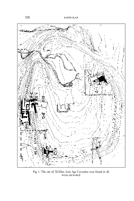
 David Ilan