- I work as a post-doctoral researcher at the Deparment of Physical Geography at Utrecht University on a new research f... moreI work as a post-doctoral researcher at the Deparment of Physical Geography at Utrecht University on a new research focus areas of the university: Future Deltas. Main research themes in this focus area are land subsidence and loss of services of deltas that are increasingly under pressure by climate change and growing popultions. These themes are studied by integrateing knowledge from various research fields, including geology, morphodynamics of coastal and river systems, biology, ecology, human geography (spatial planning, population dynamics), and socio-economic environmental and water law governance. This integrated approach is needed for a better understanding and management of deltas worldwide.edit
Many deltas contain substantial amounts of peat, which is the most compressible soil type. Therefore, peat compaction potentially leads to high amounts of subsidence in deltas. The main objective of this research was to quantify... more
Many deltas contain substantial amounts of peat, which is the most compressible soil type. Therefore, peat compaction potentially leads to high amounts of subsidence in deltas. The main objective of this research was to quantify subsidence due to peat compaction in Holocene fluvial-deltaic settings and to evaluate effects of peat compaction on delta evolution. For this purpose, field research has been carried out in the Cumberland Marshes (Canada), the Rhine-Meuse delta (The Netherlands) and the Biebrza National Park (Poland). Additionally, a new numerical peat compaction model that is calibrated with an extensive field dataset has been developed. The amount and rate of subsidence due to natural peat compaction is highly variable in space and time, mainly depending on (1) the effective stress (2) the organic-matter content of peat, (3) the thickness of the peat layer, and to a lesser extent (4) the plant species composition of peat. High-organic thick peat layers may accumulate during thousands of years without significant compaction. Most compaction occurs within decades to a few centuries after a substantial increase of the effective stress, for example caused by fluvial sedimentation on top of a peat layer, or by groundwater table lowering. Subsidence rates, due peat compaction, may be as high as 15 mm/yr. Human-induced peat compaction and oxidation may even lead to subsidence rates on the order of a few cm/yr. In deltaic environments experiencing a low sediment supply, accommodation space may be filled with peat. Subsequent compaction of this peat revitalizes existing accommodation space for increased fluvial deposition and/or peat formation. In this way, compaction-induced accommodation space increases the sediment trap efficiency, by which thick fluvial sediment layers may develop and delta propagation may be slowed down. In the Rhine-Meuse delta, subsidence due to compaction of up to ~3 m has occurred. Locally, up to ~40% of the total Holocene accommodation space has been (re)created by peat compaction. Peat compaction may locally lead to the formation of thick natural levees or crevasse-splay deposits. Generally, differential compaction initially does not increase cross-valley gradients on a floodplain, which could initiate avulsion, because compaction-induced accommodation space will usually be filled by fluvial deposition or peat formation. Moreover, regional gradients are low in peatlands, which inhibits a crevasse splay to evolve into an avulsion, as is usually the mechanism of avulsion initiation. Only if the maximum peat compaction potential at a certain location has been reached, while at a nearby location on the floodplain rates of subsidence due to peat compaction are still relatively high, differential peat compaction may lead to gradient advantages. This may affect spatial sedimentation patterns on a floodplain. Because peat compaction distorts the original stratigraphy, and through its control on regional and local sedimentation patterns, it influences the alluvial architecture of deltaic sequences, which is important knowledge for e.g. the exploration of natural resources. In populated deltas, subsidence due to peat compaction may seriously increase flood risks. Therefore, peat compaction, as well as the alluvial sequence composition, should be taken into account in delta management strategies.
This book introduces the reader to the current soil protection and conservation debate in Europe. It is written for the informed person with a background in for example environmental science, agriculture, forestry, geography or law. The... more
This book introduces the reader to the current soil protection and conservation debate in Europe. It is written for the informed person with a background in for example environmental science, agriculture, forestry, geography or law. The focus of this book is not on the scientific analysis of the problem but rather on the actions that can be taken to improve and protect European soils. Although this book is about Europe, the issues we discuss have a global dimension. We have included many examples of successful soil conservation policies and strategies adopted in other countries, for example the USA, Brazil and South Africa, as well as examples from Eastern Europe (e.g. Hungary).
The book is based on the scientific platforms that were set up as part of the SCAPE project and contains information that was presented at free and open discussion. We were able to discuss soil conservation and protection with several hundreds of stakeholders.
In Chapter 1 the reader will find an introduction and background material to the present day soil conservation and protection issues in Europe. Chapter 2 describes soil data, monitoring and information issues. In Chapter 3 we explore different aspects of sustainability. In Chapter 4 we summarise the results of many case studies, most of which illustrate the lessons that can be drawn from good practises. In Chapter 5 we discuss different approaches in policy and legislation. In Chapter 6 we present our conclusions that largely draw from the findings of the International Conference held in September 2005 in Iceland. At this meeting soil conservation scientists and practitioners got together with members of the legal profession in order to consider amongst other things, how current science and legislation possibilities could be brought together.
Meta-analysis of case studies has become an important tool for synthesizing case study findings in land change. Meta-analyses of deforestation, urbanization, desertification and change in shifting cultivation systems have been published.... more
Meta-analysis of case studies has become an important tool for synthesizing case study findings in land change. Meta-analyses of deforestation, urbanization, desertification and change in shifting cultivation systems have been published. This present study adds to this literature, with an analysis of the proximate causes and underlying forces of wetland conversion at a global scale using two complementary approaches of systematic review. Firstly, a meta-analysis of 105 case-study papers describing wetland conversion was performed, showing that different combinations of multiple-factor proximate causes, and underlying forces, drive wetland conversion. Agricultural development has been the main proximate cause of wetland conversion, and economic growth and population density are the most frequently identified underlying forces. Secondly, to add a more quantitative component to the study, a logistic meta-regression analysis was performed to estimate the likelihood of wetland conversion worldwide, using globally-consistent biophysical and socioeconomic location factor maps. Significant factors explaining wetland conversion, in order of importance, are market influence, total wetland area (lower conversion probability), mean annual temperature and cropland or built-up area. The regression analyses results support the outcomes of the meta-analysis of the processes of conversion mentioned in the individual case studies. In other meta-analyses of land change, similar factors (e.g., agricultural development, population growth, market/economic factors) are also identified as important causes of various types of land change (e.g., deforestation, desertification). Meta-analysis helps to identify commonalities across the various local case studies and identify which variables may lead to individual cases to behave differently. The meta-regression provides maps indicating the likelihood of wetland conversion worldwide based on the location factors that have determined historic conversions.
Land-use change is both a cause and consequence of many biophysical and socioeconomic changes. The CLUMondo model provides an innovative approach for global land-use change modeling to support integrated assessments. Demands for goods and... more
Land-use change is both a cause and consequence of many biophysical and socioeconomic changes. The CLUMondo model provides an innovative approach for global land-use change modeling to support integrated assessments. Demands for goods and services are, in the model, supplied by a variety of land systems that are characterized by their land cover mosaic, the agricultural management intensity, and livestock. Land system changes are simulated by the model, driven by regional demand for goods and influenced by local factors that either constrain or promote land system conversion. A characteristic of the new model is the endogenous simulation of intensification of agricultural management versus expansion of arable land, and urban versus rural settlements expansion based on land availability in the neighborhood of the location. Model results for the OECD Environmental Outlook scenario show that allocation of increased agricultural production by either management intensification or area expansion varies both among and within world regions, providing useful insight into the land sparing versus land sharing debate. The land system approach allows the inclusion of different types of demand for goods and services from the land system as a driving factor of land system change. Simulation results are compared to observed changes over the 1970-2000 period and projections of other global and regional land change models..
Current global scale land-change models used for integrated assessments and climate modeling are based on classifications of land cover. However, land-use management intensity and livestock keeping are also important aspects of land use,... more
Current global scale land-change models used for integrated assessments and climate modeling are based on classifications of land cover. However, land-use management intensity and livestock keeping are also important aspects of land use, and are an integrated part of land systems. This article aims to classify, map, and to characterize Land Systems (LS) at a global scale and analyze the spatial determinants of these systems. Besides proposing such a classification, the article tests if global assessments can be based on globally uniform allocation rules. Land cover, livestock, and agricultural intensity data are used to map LS using a hierarchical classification method. Logistic regressions are used to analyze variation in spatial determinants of LS. The analysis of the spatial determinants of LS indicates strong associations between LS and a range of socioeconomic and biophysical indicators of human-environment interactions. The set of identified spatial determinants of a LS differs among regions and scales, especially for (mosaic) cropland systems, grassland systems with livestock, and settlements. (Semi-)Natural LS have more similar spatial determinants across regions and scales. Using LS in global models is expected to result in a more accurate representation of land use capturing important aspects of land systems and land architecture: the variation in land cover and the link between land-use intensity and landscape composition. Because the set of most important spatial determinants of LS varies among regions and scales, land-change models that include the human drivers of land change are best parameterized at sub-global level, where similar biophysical, socioeconomic and cultural conditions prevail in the specific regions.
Research Interests:
Landscape ecology has provided valuable insights in the relations between spatial structure and the functioning of landscapes. However, in most global scale environmental assessments the representation of landscapes is reduced to the... more
Landscape ecology has provided valuable
insights in the relations between spatial structure and
the functioning of landscapes. However, in most
global scale environmental assessments the representation
of landscapes is reduced to the dominant land
cover within a 0.5 degree pixel, disregarding the
insights about the role of structure, pattern and
composition for the functioning of the landscape. This
paper discusses the contributions landscape ecology
can make to global scale environmental assessments.
It proposes new directions for representing landscape
characteristics at broad spatial scales. A contribution
of landscape ecologists to the representation of
landscape characteristics in global scale assessments
will foster improved information and assessments for
the design of sustainable earth system governance
strategies.
Modern and forecasted flooding of deltas is accelerated by subsidence of Holocene deposits. Subsidence caused by tectonics, isostasy, sediment compaction and anthropogenic processes, combined with eustatic sea-level rise, results in... more
Modern and forecasted flooding of deltas is accelerated
by subsidence of Holocene deposits. Subsidence caused by
tectonics, isostasy, sediment compaction and anthropogenic
processes, combined with eustatic sea-level rise, results in
drowning and increased flood risk within densely populated
deltas. Many deltaic sedimentary successions include substantial
amounts of peat, which is highly compressible compared
to clay, silt and sand. Peat compaction, therefore, may
contribute considerably to total delta subsidence. Existing
studies are inadequate for quantifying peat compaction
across deltas. We present a numerical peat compaction
model calibrated with an extensive field dataset. The model
quantifies spatial and temporal trends in peat compaction
within fluvial-dominated Holocene flood basin sequences of
different compositions. Subsidence due to peat compaction
is highly variable in time and space, with local rates of
up to 15 mm/yr, depending on sedimentary sequence. This
is extremely important information for developing sound delta
management strategies. Artificial groundwater table lowering
may cause substantial additional subsidence. Subsidence
due to peat compaction might even exceed estimates of
relative sea-level rise, and thus, may seriously increase the
risk of delta drowning and human vulnerability to flooding.
Provision of accommodation space for aggradation in Holocene deltaic basins is usually ascribed to eustatic sea-level rise and/or land subsidence due to isostasy, tectonics or sediment compaction. Whereas many Holocene deltas contain... more
Provision of accommodation space for aggradation in Holocene deltaic basins is usually ascribed to eustatic sea-level rise and/or land subsidence due to isostasy, tectonics or sediment compaction. Whereas many Holocene deltas contain peat, the relative contribution of peat compaction to total subsidence has not yet been quantified from field data covering an entire delta. Subsidence due to peat compaction potentially influences temporal and spatial sedimentation patterns, and therefore alluvial architecture. Quantification of the amount and rate of peat compaction was done based on (1) estimates of the initial dry bulk density of peat, derived from a relation between dry bulk density and organic-matter content of uncompacted peat samples and (2) radiocarbon-dated basal peat used to reconstruct initial levels of peat formation of currently subsided peat samples. In the Rhine-Meuse delta, peat compaction has contributed considerably to total basin subsidence. Depending on the thickness of the compressible sequence, weight of the overburden and organic-matter content of peat, subsidence of up to approximately 3 m in a 10-m thick Holocene sequence has been calculated. Calculated local subsidence rates of peat levels are up to 0.6 mm year−1, averaged over millennia, which are twice the estimated Holocene-averaged basin subsidence rates of 0.1–0.3 mm year−1 in the study area. Higher rates of subsidence due to compaction, on the order of a few mm year−1, occur over decades to centuries, following a substantial increase in effective stress caused by sediment loading. Without such an increase in effective stress, peat layers may accumulate for thousands of years with little compaction. Thus, the contribution of peat compaction to total delta subsidence is variable in time. Locally, up to 40% of total Holocene accommodation space has been provided by peat compaction. Implications of the large amount of accommodation space created by peat compaction in deltaic basins are: (1) increased sediment trap efficiency in deltas, which decelerates delta progradation and enhances the formation of relatively thick clastic sequences and (2) enhanced local formation of thick natural levees by renewing existing accommodation space.
Subsidence due to peat compaction may have important implications in alluvial floodplains, because it leads to wetland loss, land inundation, and damage to buildings and infrastructure. Furthermore, it potentially influences spatial and... more
Subsidence due to peat compaction may have important implications in alluvial floodplains, because it leads to wetland loss, land inundation, and damage to buildings and infrastructure. Furthermore, it potentially influences spatial and temporal river sedimentation patterns, and hence the evolution of alluvial floodplains. As the vast majority of peatlands occur in cold temperate regions, alluvial plains situated in such areas are most susceptible to these implications. To determine which locations within alluvial floodplains are most vulnerable to high amounts of compaction-induced subsidence, it is necessary to quantify compaction and to identify which factors influence the amount and rate of peat compaction. For this, we carried out field work in the Cumberland Marshes (east-central Saskatchewan, Canada) guided by the following two questions: (1) how much peat compaction has occurred over the past decades to centuries, and (2) which factors control the amount and rate of peat compaction at the same timescale. To address these questions, we used methods involving construction of stratigraphic cross sections, organic-matter content and bulk-density measurements, and radiocarbon dating. A new sampling device was devised to sample uncompacted peat in the field. Results show that peat layers have compacted up to 43% within a few centuries, with compaction rates of up to 6.08 mm/yr. The dominant factors influencing peat compaction are: (1) organic-matter content, (2) stress imposed on a peat layer, and, to a lesser extent, (3) plant species composition. In an alluvial setting, crevasse splays and natural levees are sites that are most susceptible to high amounts of peat compaction at short timescales (100–102 years). Sheet-like splay deposits initially compact underlying peat uniformly, whereas differential compaction commonly occurs beneath natural levees due to lateral variations in sediment thickness. Subsidence due to peat compaction creates additional accommodation space and hence locally enhances floodplain sedimentation rates.
Research Interests:

Peat is most compressible of all natural soils. Compaction of peat layers potentially leads to substantial amounts of land subsidence. Peat is common in many distal parts of Holocene deltas, which are often densely populated. It is known... more
Peat is most compressible of all natural soils. Compaction of peat layers potentially leads to substantial amounts of land subsidence. Peat is common in many distal parts of Holocene deltas, which are often densely populated. It is known that land subsidence due to peat compaction may have serious societal implications in such areas, as it may cause damage to construction works and lead to land inundation. Effects of peat compaction on the natural evolution of deltas are however poorly understood, whereas this might be an important control on delta evolution at both local and regional scales.
The main objective of this paper is to review current knowledge concerning the peat compaction process and its effect on delta evolution in Holocene settings, and to identify gaps in this knowledge. An overview is given regarding: 1) the compaction process, 2) presumed and potential effects of peat compaction on delta evolution, 3) field methods to quantify peat compaction and 4) numerical models to calculate the amount and rate of peat compaction.
Peat compaction and formation influence channel belt elevation, channel belt geometry and channel belt configuration. Last-mentioned aspect mostly concerns the influence of peat compaction on avulsion, which is one of the most important processes controlling delta evolution. Interactions between peat compaction, peat formation and avulsion have seldom been studied and remain unclear, partly because factors such as peat type, organic matter content, sediment sequence composition and groundwater table fluctuation are so far not taken into account. Peat compaction and formation potentially influence avulsion as 1) a decrease in accommodation space created by peat compaction underneath a channel causes superelevation and/or an increase in lateral migration, 2) the high cohesiveness of peat banks inhibits lateral migration, which increases bed aggradation, decreases sediment transport capacity and hence increases crevassing frequencies, which possibly evolve into an avulsion, although the low regional gradient in peatlands will hinder this, and 3) peat compaction and oxidation in flood basins following groundwater table lowering leads to relief amplification of channel belts. At delta scale, variations in compaction rates might stimulate the occurrence of nodal avulsions.
To quantify effects of peat compaction on delta evolution, and to determine the relative importance of different factors involved, field research should be combined with numerical models describing peat compaction and formation. The model should be validated and calibrated with field data.
A new method for determining the bulk density of uncompacted surficial peat from field settings is presented. Most importantly, a new peat sampler was developed to ensure minimum disturbance of the peat sample. The main benefits of the... more
A new method for determining the bulk density of uncompacted surficial peat from field settings is presented. Most importantly, a new peat sampler was developed to ensure minimum disturbance of the peat sample. The main benefits of the new device are (1) from the moment of field sampling, the peat sample remains undisturbed in an inner collecting liner, which has a fixed volume and fits perfectly in an outer cutting tube, until the sample is ready to be analyzed in a laboratory, (2) the risk of fracturing or disturbing the sample during lifting it to the surface is significantly reduced by using a vacuum pump or hose to reduce suction at the base of the peat core, and (3) the razor-sharp cutting edge of the outer tube easily cuts through all kinds of fibers by short rotational movements. Furthermore, sufficiently large samples can be extracted, thereby accounting for the heterogeneous character of peat. The device is relatively light and easy to operate, which is a great advantage in the often remote and difficult-to-access peatlands. The sampler was successfully used during test trials on different types of fen peat in the Biebrza National Park, Poland.
Research Interests: Geology and Sedimentary
In this paper a semi-automated method is presented to recognize and spatially delineate geomorphological units in mountainous forested ecosystems, using statistical information extracted from a 1-m resolution laser digital elevation... more
In this paper a semi-automated method is presented to recognize and spatially delineate geomorphological units in mountainous forested ecosystems, using statistical information extracted from a 1-m resolution laser digital elevation dataset. The method was applied to a mountainous area in Austria. First, slope angle and elevation characteristics were determined for each key geomorphological unit occurring in the study area. Second, a map of slope classes, derived from the laser DTM was used in an expert-driven multilevel object-oriented approach. The resulting classes represent units corresponding to landforms and processes commonly recognized in mountain areas: Fluvial terrace, Alluvial Fan, Slope with mass movement, Talus slope, Rock cliff, Glacial landform, Shallow incised channel and Deep incised channel. The classification result was compared with a validation dataset of geomorphological units derived from an analogue geomorphological map. For the above mentioned classes the percentages of correctly classified grid cells are 69%, 79%, 50%, 64%, 32%, 61%, 23% and 70%, respectively. The lower values of 32% and 23% are mainly related to inaccurate mapping of rock cliffs and shallow incised channels in the analogue geomorphological map. The accuracy increased to 76% and 54% respectively if a buffer is applied to these specific units. It is concluded that high-resolution topographical data derived from laser DTMs are useful for the extraction of geomorphological units in mountain areas.
The IGLO project on global and local scale land change model is presented during the final seminar of the project. The presentation is a start for a discussion on assessing future land cover and land use
The IGLO project on land use change models is presented and discussed during the mid-term Knowledge for Climate conference.
A new global land change model is presented and discussed.
We did a systematic, worldwide comparative assessment of wetland conversion and its causality to better understand the proximate and underlying driving processes. For this purpose we carried out a meta-analysis of local case-studies. Such... more
We did a systematic, worldwide comparative assessment of wetland conversion and its causality to better understand the proximate and underlying driving processes. For this purpose we carried out a meta-analysis of local case-studies. Such meta-analyses have already been done for tropical deforestation (Geist and Lambin, 2002; Rudel, 2008), desertification (Geist and Lambin, 2004), agricultural intensification in the tropics (Keys and McConnell, 2005), and for swidden agriculture changes in tropical forest-agriculture frontiers (Van Vliet et al., 2012), but not yet for wetland conversion. The meta-analysis is used to evaluate which driving processes of wetland conversion occur most frequently, and how these processes interact. Such information can be used to develop sustainable wetland conservation strategies. In addition, a logistic regression analysis is carried out to predict the probability of wetland conversion at a global scale. The results of these regression analyses can be used in global-scale assessment models that assess environmental consequences of human activities, like the GLOBIO model of human impacts on biodiversity (Alkemade et al., 2003).
Humans have changed the natural global environment for millennia, for example by converting natural land into settlements, cropland and grazing land. Especially during the last three centuries rapid land changes occurred due to the... more
Humans have changed the natural global environment for millennia, for example by converting natural land into settlements, cropland and grazing land. Especially during the last three centuries rapid land changes occurred due to the increasing demand for agricultural products.
Integrated Assessment Models (IAM’s) are frequently used to estimate environmental consequences (e.g. climate change) of interactions between different systems, such as economic, social and biophysical systems. Land-use is a fundamental component of IAMs, most importantly because it is both a cause and consequence of natural and socioeconomic processes. At present, many global land-use change models use relatively coarse pixels (~50x50 km) that represent one dominant land cover, while land management is ignored or represented in a simplified way. In this presentation, I will present a new representation of global land-use that is based on Land Systems. The method aims to improve the representation of future land changes in IAM’s.
Agricultural intensity and livestock systems are major causes of environmental damages, and hence are important variables to include in global scale environmental change assessments. Therefore, Land Systems are classified based on information on these two factors, besides on land cover composition. Land Systems are classified at a resolution of ~10x10 km. Regression analyses are used to explore how a set of biophysical and socioeconomic factors explain the spatial distribution of Land Systems. These rules can subsequently be used to allocate future land changes.
Many deltaic sedimentary successions include substantial amounts of peat, which is highly compressible compared to clay, silt and sand. Peat compaction, therefore, may contribute considerably to total delta subsidence accelerating the... more
Many deltaic sedimentary successions include substantial amounts of peat, which is highly compressible compared to clay, silt and sand. Peat compaction, therefore, may contribute considerably to total delta subsidence accelerating the rate and enhancing the amount of relative sea-level rise, increasing flooding risk within these low-lying, often densely populated areas. Existing studies have critical shortcomings for quantifying peat compaction across deltas. We present a numerical peat compaction model calibrated with an extensive field dataset. The model quantifies spatial and temporal trends in peat compaction within fluvial-dominated Holocene floodbasin sequences of different compositions. Subsidence due to peat compaction is highly variable in time and space, with local rates of up to 15 mm/yr, depending on sedimentary sequence. This is extremely important information for developing sound delta management strategies. Substantial additional subsidence may be caused by artificial groundwater table lowering. Subsidence due to peat compaction might even exceed estimates of relative sea-level rise, and thus, may seriously increase the risk of delta drowning and human vulnerability to flooding.
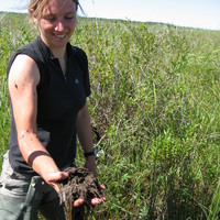
Soil subsidence due to natural peat compaction in the Rhine-Meuse delta (field work results).
Alluvial plains like deltas often contain thick peat layers. Peat has several distinctive properties compared to inorganic sediments, which affect processes and the geometry of alluvial rivers. One of these properties is the high... more
Alluvial plains like deltas often contain thick peat layers. Peat has several distinctive properties compared to inorganic sediments, which affect processes and the geometry of alluvial rivers. One of these properties is the high compressibility of peat, which potentially leads to high amounts of land subsidence. Peat compaction likely plays an important role in the evolution of alluvial plains, for example by providing extra accommodation space, which affects temporal and spatial fluvial sedimentation patterns. It has also been suggested that differential peat compaction affects floodplain gradients, and hence may affect the occurrence of avulsion. In such ways, peat compaction influences the alluvial architecture of both modern and ancient alluvial sequences, which is important knowledge for e.g. the exploration of natural resources such as oil and gas.
Still, there is a lack of field data to test such hypothesis. Therefore, field research, using new methods to quantify peat compaction, was carried out in the Cumberland Marshes (Canada) and the Rhine-Meuse delta (The Netherlands), where processes occurring on respectively decades and millennia timescales were studied. Most important factors controlling the amount of subsidence due to peat compaction are 1) the organic matter content of peat, 2) stress imposed on a peat layer by loading, 3) thickness of the compressible substrate, 4) relative vertical position in a peat layer, and 5) peat composition. Much compaction (=thickness reduction / original thickness) occurs shortly after loading; within decades up to 43% compaction might occur. In the Rhine-Meuse delta, where peat layers are up to ~8 m thick, peat compaction has led to subsidence of up to 3 m.
On short timescales (101-102 years), high amounts of peat compaction locally occur due to loading by crevasse splay or natural levee deposits. As the created additional accommodation space is rapidly filled by increased fluvial sedimentation or by peat accumulation, no gradient advantages are created which could drive avulsion. Peat compaction below channel deposits rather leads to vertical aggradation and fixation of river channels. In addition, lateral migration is inhibited by river banks consisting of mainly peat, which is highly resistant to fluvial erosion. On longer timescales, when the maximum compaction potential of peat layers in an area has largely been reached, delta lobes become prone to switch to another part of the alluvial plain.
Thick peat layers are common in many deltas, especially in distal parts. Land subsidence due to peat compaction has important well-known societal implications; e.g., damage to construction works and increased flooding risks. Effects of... more
Thick peat layers are common in many deltas, especially in distal parts. Land subsidence due to peat compaction has important well-known societal implications; e.g., damage to construction works and increased flooding risks. Effects of peat compaction on floodplain morphology are however poorly understood. Such effects are investigated during an extensive field campaign in the Cumberland Marshes (Canada), using new methods to reconstruct the amount and rate of peat compaction. Results show that the amount of peat compaction is highly dependent on peat type, organic matter content and thickness and type of overlying sediments. In floodplain environments, these conditions show a high spatial and temporal variability. In general, greatest volume reductions due to compaction occur in peat layers with a high organic matter content loaded with a relatively thick layer of silty/sandy material, such as underneath natural levees. Due to the high amount of compaction at such places, additional accommodation space is created which results in thick natural levees. This suggests that initially peat compaction fixes river channels and prevents avulsion. However, distal parts of deltas are also characterized by a high avulsion frequency (e.g., Cumberland Marshes, Rhine-Meuse delta). How these two observations can be explained is still under investigation.