Ypsonas
Ypsonas
| |
|---|---|
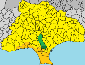
 Ypsonas (green) within the Limassol District (yellow) | |
Location within Cyprus Location within the Eastern Mediterranean Location within the European Union Location within Asia | |
| Coordinates: 34°41′22″N 32°57′41″E / 34.68944°N 32.96139°E | |
| Country | |
| District | Limassol District |
| Urban area | Limassol |
| Area | |
| • Municipality | 32.38 km2 (12.50 sq mi) |
| Population (2011)[2] | |
| • Municipality | 11,117 |
| • Density | 340/km2 (890/sq mi) |
| Time zone | UTC+2 (EET) |
| • Summer (DST) | UTC+3 (EEST) |
| Website | https://ipsonas.org/ |
Ypsonas or Ipsonas (Greek: Ύψωνας, romanized: Ypsōnas, Turkish: İpsona), is a municipality in the Limassol of Cyprus. It is one of the largest municipalities in the district and is located about 7 kilometres (4.3 mi) west of Limassol.[3] The southern part of the municipality is within the administrative borders of the British sovereign base of Akrotiri - Episkopi. It has 11,117 residents as recorded in the Census of 2011.[4]
History and archaeology
[edit]Ypsonas has existed since the Middle Ages. Farmers from Lofou used to migrate seasonally to Ypsonas. Permanent settlement began during the British rule.[5] Today, traces of churches built in medieval times are to be seen related to St. Agios Sylas.[6]
Ypsonas is one of the biggest municipalities in Limassol and is situated about 7 kilometres (4.3 mi) west of the city. The southern part of it belongs to the British sovereign base of Akrotiri and is managed by the British Police of Akrotiri.
The last decades Ypsonas is found with a variety of professional cultivations of fruit and vegetables such as for wine, orange range, carob, and lesser of other fruits. Other types of industrial productions include: processed meats, cheese industries, cement industries, manufacture of wooden furniture and packaging of agricultural products. It employs the fourth-largest employee personnel in the general area of Limassol city in Cyprus.
Many of its permanent residents work for tourism, trade, transport and services and many non-Cypriot labourers are seasonal workers in the agricultural part of Ypsonas.
The number of permanent residents grew significantly from just 3 in 1881 to 10,950 by the 2011 census. Initially, there were only 3 residents in 1881, increasing to 4 in 1892. By 1901, the population had risen to 21. In 1921, it reached 167, and by 1931, there were 256 residents. The population continued to grow, with 492 residents recorded in 1946. By 1960, the number had increased to 1,496, and in 1973, it was 2,043. The count reached 3,061 in 1982, and by 2011, there were 10,950 residents.
Although legend has it that Ypsonas was established by immigrants from another municipality in Cyprus, starting with the first individual who moved from Lofou to Ypsonas (Giorkatzis Chatzistyllis, born in 1887 in Lofou), who initially tended his lands in Ypsonas by traveling there on a donkey from Lofou seasonally, and later decided to settle permanently in the area, the history is not so straightforward. The location has existed since the Medieval Era, as evidenced by its name ‘Ipsonas’ on medieval maps. In 1426, the Mamluks of Egypt invaded Cyprus and seized Limassol, beginning their invasion from Episkopi. This leads to the theory that Ypsonas was destroyed during the Mamluk invasion and later again during the 1570 invasion of Cyprus by Turkish ships, which attacked Limassol and reached the Polemidia area near Ypsonas.[7]
Today, Ypsonas has an economic growth due to industrial activity, the expansion of the municipality and enhancements in infrastructure.[8] It had become from a tiny village into a large municipality with more than 10,000 residents, and a broad range of amenities.
The Municipality has decided to maintain the traditional architecture of old houses within the old city and does not allow the introduction of architectural elements that do not coincide with said style in the proximity of St. George's Church.[9]
Archaeology for this area is found mainly in its medieval heritage, either the very old homes in the old part of the municipality where they retain even through renovations their original character. The medieval site of Agios Sylas is known as the main archaeological attraction of the municipality.[6]
Part of the Ypsonas municipality belongs to the United Kingdom Sovereign Base Areas.[10][circular reference] [11] This area has its own separate police (the British Forces in Cyprus Police) but the number used to call them is 112, the same as in the Republic of Cyprus and all countries in the European Union. The SBA of Akrotiri that expands to parts of Ypsonas is open to access to vehicles and humans without border control and it incorporates the villages: Ypsonas, Erimi, Akrotiri, Asomatos, Avdimou, Trachoni, Fasouri, Sotira, Tserkezoi, Pisouri, Kolosi, Episkopi and Paramali.[11]
Demographics
[edit]The population of Ypsonas has increased steadily since the late 19th century.[5]
Religion
[edit]
Ypsonas has three churches and three smaller chapels,[12] for its predominantly Greek Orthodox community.[13]
- Holy Church of Agios Savvas (Ιερὸς Ναὸς Άγιου Σάββα), built in 2007
- Holy Church of Saint Mary Chryssopolitissa (Ιερὸς Ναὸς Παναγίας Χρυσοπολιτίσσης), built around 1839
- Holy Church of Saint George The Poor (Ιερὸς Ναὸς Ἁγίου Γεωργίου του Φτωχού), built in the 1950s
- Chapel of Saint George Vikliou (Άγιο Γεώργιο του Βικλιού), a modern tiny chapel built by religious residents near the Agios Sylas area
- Chapel of Saint Vichianos (Ξωκλήσι του Αγίου Βηχιανού), built in 1969 based on legends of an older church with the same name
- Chapel of Saint Raphael (Ξωκλησι του Αγίου Ραφαήλ), built in 1995 in old Byzantine-style stavroides me troulo
Politics and government
[edit]Since the erection of the Ypsonas Municipality in 2012, there have been 2 Mayors.
| Year(s) served | Name of Mayor | Ref. |
|---|---|---|
| 2012-2016 | Aristos Palouzas | [14] |
| 2017-incumbent | Pantelis Eftichiou Georgiou | [15] |
Education
[edit]Ypsonas has many elementary schools and 1 Gymnasium plus 1 continuing education school for adults [16] plus a continuating education school for adults according to the EU mandate for life-long learning[17]
Transport
[edit]Ypsonas is served by local Limassol bus lines 17 and 16. In this way Ypsonas is connected to Limassol centre. Large avenue Elias Kannaourou and the main Cyprus highway connect Ypsonas to Limassol and other cities.
Geography
[edit]Topography
[edit]Ypsonas is built at an altitude of 90 meters. The village area has an inclination from north to south. The altitude decreases from 479 in north to 90 in the village level and to 20 towards southern parts.
Climate
[edit]Ypsonas has an annual rainfall of 440 cm. The open cultivated fields of Ypsonas Industrial area do not have any tall buildings and thus the temperature in summer can be higher than within the shaded (due to buildings) city of Limassol. Ypsonas also may have more wind than Limassol city for the same reason.[5]
Economy
[edit]

The Industrial Area of Ypsonas has many cultivated fields which produce ready-made grass, vines, citrus fruits, almonds, olives, carobs, and milk from goat herds.

In the same area, large cement factories operate, as well as much used car-parts processing.
Ypsonas has a blooming industry development. The number of people that work in industries in this area are the fourth-largest in Limassol. The main industrial factories are charcuteries, cheese and cured meat factories, saw factories, boat manufacturing factories, and wooden furniture factories as well as product and packing of fruit and vegetable products. There are since 2000s more restaurants of internationally known fast foods chains, like KFC, Costa Coffee and more and supermarkets like LIDL, Papantoniou, and Pop Life.
Sports
[edit]Ypsonas has gyms, soccer stadiums and teams including Digenis FC, tennis academy Ioannides and Krasava ENY Ypsonas FC.
References
[edit]- ^ "Cyprus: Limassol Urban Agglomeration (Municipalities, Communities and Quarters) - Population Statistics, Charts and Map". www.citypopulation.de. Retrieved 2024-10-04.
- ^ Census 2001
- ^ Map in the municipality of ypsonas website
- ^ 2011 Population Census, MS Excel document. Statistical Service of the Republic of Cyprus, 2012.
- ^ a b c "Ypsonas", Cyprus Island.
- ^ a b Agios Sylas
- ^ Petros Porakos (2004). Λόφου οι άνθρωποι της στο χώρο και στο χρόνο [Lofou, People in Space and Time] (in Greek). Lemesos: Philis Publications. ISBN 9963793339.
- ^ https://ipsonas.org/enimerosi/anaptyksiaka-erga/ (official page of the Ypsonas Municipality available only in Greek for now)
- ^ https://ipsonas.org/o-dimos-mas/istoriki-anadromi/ (official page of the Ypsonas Municipality available only in Greek for now)
- ^ Akrotiri and Dhekelia
- ^ a b Google Maps showing SBA in Akrotiri that expands to Ypsonas village
- ^ "Εκκλησίες και Παρεκκλήσια".
- ^ Churches in Ypsonas
- ^ "Διατελέσαντες Δημάρχοι".
- ^ "Βιογραφικό".
- ^ "Δημόσια Εκπαίδευση".
- ^ "Σχολείο "Δια Βίου Μάθηση"".


