- National Aerospace Laboratories, CSIR 4PI, Department Memberadd
- Young Researcher in the field of Geological Remote Sensingedit
- Dr. Lakshumanan Cedit
The coastal stretch of Kanyakumari district in Tamil Nadu, India is enriched with a variety of heavy minerals. The present study deals with the textural analysis, mineralogy and geochemistry of this placer deposits. Granulometric studies... more
The coastal stretch of Kanyakumari district in Tamil Nadu, India is enriched with a variety of heavy minerals. The present study deals with the textural analysis, mineralogy and geochemistry of this placer deposits. Granulometric studies carried out on the study area shows that sands of all the sectors fall in medium and fine grade sand fraction with
moderately well sorted to moderately sorted nature. The moderate winnowing action results in the mixing of coarse and fine sediments in the coast. Linear Discriminative Function reveals all the samples fall in Shallow agitated Beach deposits and deposited by rolling, Bottom suspension and rolling mechanism. The sediments are formed under low energy level and results the deposition is mainly of fine to medium sediments. According to heavy mineral distribution, heavy minerals are mostly concentrated in both the eastern and western sector of the study area. The Isodynamic -Magnetic separator method also state the same result, it reveals that Ilmenite dominated in this study area and it is followed by the concentration of garnet. XRF data shows the presence of major oxides like TiO2 and Fe2O3 in the sample.Weathering mechanism of Ilmenite shows that they come under ferrian ilmenite.
moderately well sorted to moderately sorted nature. The moderate winnowing action results in the mixing of coarse and fine sediments in the coast. Linear Discriminative Function reveals all the samples fall in Shallow agitated Beach deposits and deposited by rolling, Bottom suspension and rolling mechanism. The sediments are formed under low energy level and results the deposition is mainly of fine to medium sediments. According to heavy mineral distribution, heavy minerals are mostly concentrated in both the eastern and western sector of the study area. The Isodynamic -Magnetic separator method also state the same result, it reveals that Ilmenite dominated in this study area and it is followed by the concentration of garnet. XRF data shows the presence of major oxides like TiO2 and Fe2O3 in the sample.Weathering mechanism of Ilmenite shows that they come under ferrian ilmenite.
Research Interests:

Ocean zoning through marine spatial planning (MSP) is an important component of the blue economy and has become an essential step towards realizing ecosystembased sea-use management. The concept was primarily initiated by the need to... more
Ocean zoning through marine spatial planning (MSP) is an important component of the blue economy and has become an essential step towards realizing ecosystembased sea-use management. The concept was primarily initiated by the need to create marine protected areas, particularly in the European countries. An even more recent concern has focused on the need to conserve nature, especially ecologically and biologically sensitive areas in the context of multi-use planning of ocean space. To understand the value of MSP in India, a framework was created as part of the Indo-Norway International Ocean Management and Research Initiative. This study provides a framework for MSP in India for sustainable development in an ecologically sensitive area, namely the Lakshadweep group of islands on the west coast of the country. The findings of this study may serve as a reference for better management of maritime regions under various spatial jurisdictions.
Research Interests:
The coastal area is a dynamic and fragile environment which is very essential for many purposes such as resident, recreation, tourism, fisheries, agriculture, etc. Agriculture and fishing are the major source of developmental activities... more
The coastal area is a dynamic and fragile environment which is very essential for many purposes such as resident, recreation, tourism, fisheries, agriculture, etc. Agriculture and fishing are the major source of developmental activities done by the local community in the coastal region. Therefore, coastal instability will directly affect the socio-economic conditions of the people residing nearby the coastline. This coastal instability will occur by both natural (Sea level rise, erosion and accretion) as well as anthropogenic factors (recreational activities, developmental activities and the construction of protection structures). This change in coastline will create a socio-economic impact to the local community. This study examines the changes in shoreline that occurred during the past two decades (2000 to 2020) along the Kanyakumari region in the southern tip of India. The results indicate a major retreat with some sea-ward movement due to sediment accumulation. Even though, the shoreline appears to be naturally dynamic due to long shore currents and beach morphology, the sediment movement due to external anthropogenic pressure exhibited a direct impact over the shoreline. A large part of the shoreline experienced erosion during the study period mostly due to construction of protective structures such as groins, jetties and sea walls. Major erosions were observed over the regions nearby harbors. Compared with the east coast region, the western part experiences more erosion which may be due to high energy waves. Coastal dunes in the Rajakkamangalam sector especially in locations Chothavilai, Sanguthurai, Periyakadu and Rajakkamangalam acts as a barrier against wind and waves keeping the inland areas safe from coastal hazards. More number of jetties and breakwaters were constructed during the past decade which eventually induces erosion in the one side and deposition on the other. Coastal villages such as Poothurai, Thengapattinam, Melmidalam, Colachel, Manavalakurichi and Kovalam experiences higher rate of erosion. This increased erosion will leads to the destruction of coastal properties and reduced fish catches which will deploy the economic growth of the region. It is also noted that, the coastal stretches should have been planned and monitored better through continuous observation of sea level rises and other potential environmental hazards. Hence, there is a need to develop proper interventions for sustainable coastal resource utilization.
Research Interests:
Research Interests:
During the last few decades, contamination of air, water and soil has become the talk of the era due to high anthropogenic influence especially in the metropolitan cities. Taking this in mind, this study is taken place to identify the... more
During the last few decades, contamination of air, water and soil has become the talk of the era due to high anthropogenic influence especially in the metropolitan cities. Taking this in mind, this study is taken place to identify the influence of anthropogenic activity by assessing pollution of selected heavy metals in an urbanized environment. Concentrations of five heavy metals (Cd, Pb, Zn, Cr, and Cu) in 155 urban soil samples collected from an area covering ca.595 km 2 across the Greater Chennai Region (GCR) at the coast of Bay
Research Interests:
Cumulative urban and industrial activities have triggered remarkable modifications in the land use and landcover of southernmost Indian subcontinent. This study presents spatial distributions and enrichments of eighteen major and trace... more
Cumulative urban and industrial activities have triggered remarkable modifications in the land use and landcover of southernmost Indian subcontinent. This study presents spatial distributions and enrichments of eighteen major and trace elements in sediments of the foredune (D) and beachface (B) landforms present along the coastal stretch of Kanyakumari with respect to the continental crust to evaluate the possible geogenic and anthropogenic influences. Ti (D: 76,842 mg/kg; B: 57,053 mg/ kg) is the most abundant among the elements and Cd (D: 4 mg/kg; B: 4 mg/kg) is the least abundant one. Extremely high (by enrichment factor) and very high (by contamination factor) enrichments of Ti, Cd, Mo, Th, and Zr reflect the influences of heavy minerals such as ilmenite, monazite, zircon, garnet, and rutile, and the Igeo values mirror their variable abundances across the sampling sites. Cd enrichment, in few sites, could be due to the sewage from fishing harbors. This baseline data of elemental concentrations (some potentially toxic metals) from a scarcely studied part of India are useful for the short-and long-term monitoring of growing anthropogenic activities related to the tourism and industry.
A framework was set up to monitor drought in the semi-arid regions of eastern Tamil Nadu, southern India, for the period of 2014–2018 CE with the application of the standardized precipitation index (SPI), the scaled drought-condition... more
A framework was set up to monitor drought in the semi-arid regions of eastern Tamil Nadu, southern India, for the period of 2014–2018 CE with the application of the standardized precipitation index (SPI), the scaled drought-condition index (SDCI), and the standardized water-level index (SWI). The results emphasized that this region had a negative precipitation anomaly and vegetative stress, both of which triggered meteorological and agricultural droughts and caused significant losses in the farming sector. The distributions of extreme and high-level hydrological droughts were at their maximum in 2017 CE. The multi-drought severity index (MDSI), implemented to assess the combined impact and highlighting the gradient of affected areas, illustrated that the eastern region (i.e., Jayankondam block) was the most extremely affected, followed by the northern and southern regions (i.e., T.Palur and Andimadam), which were moderately affected by droughts. The extremely affected eastern region...
Research Interests:
We estimated shoreline changes over the last five decades in a part of the southeast coast of India at Cuddalore by using multitemporal satellite images from six different time-windows (i.e. 1972, 1980, 1990, 2000, 2010 and 2020) and the... more
We estimated shoreline changes over the last five decades in a part of the southeast coast of India at Cuddalore by using multitemporal satellite images from six different time-windows (i.e. 1972, 1980, 1990, 2000, 2010 and 2020) and the digital shoreline analysis system tool (DSAS 5.0). The linear regression rate and end point rate quantified the maximum erosion at rates of 6.8-7.2 m/year and the maximum accretion at rates of 3.9-4.2 m/year at different sites along the 42 km stretch that was affected by several disasters in the recent past and has a substantial industrial presence. The net shoreline movement analysis identified the sites that experienced about 340 m of erosion and about 203 m of accretion. The Kalman filter model predicted up to 274 m of the shoreline erosion at Chinna vaaikaal until 2040. Similarly, the shoreline at Puthupettai could be accreted up to 538 m over the same interval. The outcome of this research demonstrates that studies similar to ours should be carried out in different parts along the vast Indian coastline to understand the shoreline evolution in order to prepare a better coastal management strategy.
Research Interests:
Beach sediments of Kanyakumari at the southernmost India were evaluated for metals and trace elements and to assess their possible impact on coastal ecosystems. Positive correlations (except for Cd and Sr) between them indicated... more
Beach sediments of Kanyakumari at the southernmost India were evaluated for metals and trace elements and to assess their possible impact on coastal ecosystems. Positive correlations (except for Cd and Sr) between them indicated metamorphic lithologies and heavy mineral deposits as possible sources. Significant-extremely high enrichment and very high contamination of Th, Zr, Mo, Ti and U reflected the presence of different heavy minerals. The geo-accumulation index, however, mirrored their variable abundances at different sites. Association of Cd with P suggested the influence of anthropogenic solid waste from fishing industry. It might have caused >41-fold enrichment of Cd and the Fe-Mn-oxides possibly acted as scavengers for 13-fold enrichment of As compared to UCC. Concentrations of Zn and Cr between ERL and ERM in 13% and 93% of the samples, and Ni > ERM in 87% of sediments suggest their bioavailability to seawater with a potential risk for coastal aquifers.
Research Interests:
The present study provides details of benthic foraminifera analyzed from hundred beach sediment sub-samples collected from the Anthakara Nazhi beach, Kerala coast, the west coast of India. A total of 27 species of benthic foraminifera... more
The present study provides details of benthic foraminifera analyzed from hundred beach sediment sub-samples collected from the Anthakara Nazhi beach, Kerala coast, the west coast of India. A total of 27 species of benthic foraminifera were recorded from this region. This study proved that the benthic foraminifera are good proxies to understand the paleoproductivity changes from this region. Oceanographically, important benthic foraminiferal species such as Ammonia beccarii along with Anomalina globulosa, Ammonia gaimardii, Cancris oblongus, Discopulvinulina bertheloti, Gyroidinoides nitidula, Gyroidinoides cibaoensis, Quinqueloculina seminulum, Quinqueloculina venusta and Textularia sp. were identified and counted. Benthic foraminifera analyses suggest a high productivity species are Ammonia beccarii and Ammonia gaimardii from 100 to 80cm and 20 to 5 cm depth an increasing trend an indicative of a shallow-marine environment. A strict interpretation based on the known modern distribution of Ammonia beccarii would confine the species to upper shore-face environments. The moderate values of Cancrisoblongus from 30 to 10 cm depth indicate by tolerance to mesotrophic-eutrophic conditions. Interval of 70 to 40 cm depth of species Gyroidinoides nitidula indicates low organic carbon flux or pulsed food supply and high oxygen environment. From 50 to 20 cm depth, species Gyroidinoides cibaoensis has been described from oxygenated deep waters of the northwestern Indian Ocean receiving intermediate flux of organic matter.
Research Interests:
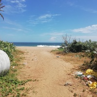
Increasing urbanization and anthropogenic activities of the last couple of decades have left significant amounts of plastic debris in both coastal and marine ecosystems. In this study, we estimated the abundance of microplastics (particle... more
Increasing urbanization and anthropogenic activities of the last couple of decades have left significant amounts of plastic debris in both coastal and marine ecosystems. In this study, we estimated the abundance of microplastics (particle size < 5 mm) in the beach sediments of southernmost India at Kanyakumari by collecting sediments from harbors, coastal fishing villages/residential beaches, tourist beaches, and undisturbed coastal areas along the Indian Ocean.We recovered 343 particles (67% fiber and 33% fragment) from eight different stations by evaluating 50 g dry sediments (d.s.) from each location. All of them were secondary microplastics and most of them (i.e., 331 out of 343 particles) were transparent. Tourist beaches had the highest concentration (150 particles/50 g d.s.), followed by the harbors (99 particles/50 g d.s.). The undisturbed beach contained the least amount of microplastics, representing only 4.3% of the total recovered particles. Our study relates the abundance of microplastics to different degrees of anthropogenic activities. Further research, however, is required to identify the mechanism that influenced
their transport and deposition in the coastal sediments as well as to evaluate the possible interaction between microplastic particles and marine ecosystems.
their transport and deposition in the coastal sediments as well as to evaluate the possible interaction between microplastic particles and marine ecosystems.