- Muzeu Arkeologjik
Shetitorja "Taulantia"
Durres
Albania
Eduard Shehi
Albanian Institute of Archaeology, Department of Antiquity, Faculty Member
- Arcaheology, Illyrian Archaeology, Albanian archaeology, Roman Pottery, Pottery (Archaeology), Pottery technology and function, and 67 moreHellenistic Pottery, Late Roman Pottery, Greek Pottery, Ancient Pottery Analysis, Roman stamped pottery, Roman Pottery Kilns, Pottery kilns, Hellenistic Pottery - black glaze, Etruscan and Corinthian Pottery, Reception of Antiquity, Pottery, Albanian Studies, Durres, Dyrrachium, Ancient Topografy, Cook Wares, Dyrrhachium, Dédicaces Peintes, Dyrrhachion, Durazzo, rescue excavatoin Durres, topografia Dyrrachium, Roman History, Greek History, Roman Archaeology, Roman brick and tiles, Roman Urbanism, Roman Architecture and Urbanism, Roman Architecture, Classical Archaeology, Pompeii (Archaeology), European Archaeology, Palaeoeconomy, Archaeology, Archaeology and politics, Nationalism and Archaeology, Archaeological Method & Theory, Funerary Archaeology, Death and Burial (Archaeology), Mediterranean archaeology, Archaeological Theory, Social Archaeology, Ancient Roman economy, trade and commerce, Roman Economy, Ancient economies (Archaeology), Ancient economy, Roman Empire, Ancient History, Roman Trade Networks, Roman social and economic history, Maritime Transport Geography, Amphorae (Archaeology), Ancient Trade & Commerce (Archaeology), Paleohydrology, Paleoclimatology, Palaeoclimate, Archaeology of Mediterranean Trade, Geoarchaeology, Geomorphology, Ceramics (Archaeology), Ceramic Analysis (Archaeology), Ceramic Technology, Material Culture Studies, Archaeometry, Roman Crisis of the Third Century, 3rd Century AD, and Crisis of the 3rd Centuryedit
- Interested on new discoveries to improve the knowledge for the past.edit
Artikulli trajton aspekte të strukturës administrative të Durrësit mesjetar. Identifikohet koncepti i dekarkive si njësi bazë e organizimit territorial qytetas, i ngjashëm me disa qytete italiane. Për çdo dekarki duhej të kishte 2... more
Artikulli trajton aspekte të strukturës administrative të Durrësit mesjetar. Identifikohet koncepti i dekarkive si njësi bazë e organizimit territorial qytetas, i ngjashëm me disa qytete italiane. Për çdo dekarki duhej të kishte 2 përfaqësues, dëshmuar nga një Këshill i të 12-ve. "Topothésia" lidhet me traditën bizantine, përdorur për administrimin e territorit bujqësor të kultivuar. Si drejtues i pushtetit ekzekutiv përmendet Rectori dyrachij. Përgjatë qeverisjes së Topiajve hasim tri pozicione ushtarake: kapiten; kështjellar; komestabël. Në dy dokumente hasim protovestiarius, me traditë bizantine, dhe komunitetin durrsak. Topiajt duhet të kenë ruajtur pozicionet e ulëta për mbarëvajtjen e punëve të përditshme, por kanë eliminuar postet e larta, duke përqendruar pushtetin te baronët pranë feudalit. Me kalimin e Durrësit nën Venedikun, përdorimi i sistemit të administrimit me qeveritarë venedikas të zgjedhur zhduku përfundimisht sistemin komunal të drejtimit të qytetit.
Research Interests:

Research Interests:
This article will discuss the archaeological traces associated with ancient shrines discovered in Durrës and further inland. Nine cases have been identified where the published evidence is convincing enough to locate the position of... more
This article will discuss the archaeological traces associated with ancient
shrines discovered in Durrës and further inland. Nine cases have been identified
where the published evidence is convincing enough to locate the position of shrines
across the territory. The case for each shrine will be outlined individually, after which
aspects relating to their chronology and topography will be discussed.
The author has dealt broadly with problems related to the origin of these
shrines and their relationship with indiginous populations. Discussions also include:
the positioning of shrines within the geomorphology of the terrain; the visual aspect
of shrine locations; the concept of temple duality; the reasons for constructing temples
in particular places; the possible identification of those gods to whom the temples
were dedicated; the attributes of these gods and the geographical positioning of their
temples; the operation of shrines within the polis territory, and their abandonment.
Finally, the author situates the information provided by these nine temples
within the historical context of the establishment and development of the Epidamnus.
The author concludes by making it clear that this article should be considered a first
step towards a fuller study with a more in-depth theoretical analysis of the issue.
Research Interests:
Research Interests: Archaeology, Ottoman History, Albanian Studies, Archaeological Method & Theory, Ottoman Archaeology, and 12 moreOttoman Studies, Ottoman Empire, Economic and Social History of the Ottoman Empire, Albania, Late Ottoman History, Albanian archaeology, Osmanlı Sosyo-Ekonomik Tarihi, Osmanlı İmparatorluğu, Osmanlı Tarihi, Osmanlı Devleti, Osmanlı Müesseseleri Ve Medeniyeti Tarihi, and Albanian History
Research Interests:
Research Interests:
The Dyrrachium Hinterland Project is focusing on the landscape along the two main roads leading from Durrës towards the southeast; firstly the road leading towards Kavajë, and secondly the road leading from Arapaj towards the Erzen river... more
The Dyrrachium Hinterland Project is focusing on the landscape along the two main roads leading from Durrës towards the southeast; firstly the road leading towards Kavajë, and secondly the road leading from Arapaj towards the Erzen river and Romanat. These routes were of great importance already during Antiquity; the Via Egnatia following the first route and the Hadrianic aqueduct leading water to Dyrrachium from the river Erzen along the second.
Research Interests:
Research Interests:
Research Interests:
... française en Albanie, financés par le Ministère des Affaires étrangères et européennes, en collaboration avec l'Institut Archéologique d'Albanie et les Écoles françaises d'Athènes et de Rome, ont commencé en 1992 sous... more
... française en Albanie, financés par le Ministère des Affaires étrangères et européennes, en collaboration avec l'Institut Archéologique d'Albanie et les Écoles françaises d'Athènes et de Rome, ont commencé en 1992 sous la direction de Pierre Cabanes et de Neritan Ceka[1] [1 ...
Research Interests:
Research Interests:
Research Interests:
Research Interests:
Research Interests:
Research Interests:
Rapport sur les 5e et 6e campagnes d'étude des trouvailles du sanctuaire de la colline de Dautë à Durrës (Epidamne-Dyrrhachion).
Research Interests:
Research Interests:
Research Interests:
Deux fragments de skyphoi portant des dédicaces peintes dans la technique de la figure rouge permettent de confirmer l'identification du sanctuaire d'Artémis à Dyrrhachion.
Research Interests:
Research Interests:
Research Interests: Greek Archaeology, Ancient Greek Religion, Votive practice, Terracotta Figurines, Albanian archaeology, and 10 moreGreek sanctuaries, Anthropomorphic Figurines, Coroplastic Studies, Artemis, Dyrrachium, Illyrian Archaeology, Coroplastica, Votive offerings, Votive offerings, Greek sanctuaries, and Epidamne
Research Interests:
Research Interests:
Research Interests:
Research Interests:
Research Interests:
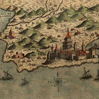
The aim of this paper is related with the treatment of the main military topographic aspects of the city of Durrës during the Ottoman period. This goal we tried to achieve through combining the data taken from different sources. In... more
The aim of this paper is related with the treatment of the main military
topographic aspects of the city of Durrës during the Ottoman period. This goal we tried to achieve through combining the data taken from different sources. In relation with the city's fortifications, it's already clear that their evolution is more complicated that has thought. Also, already we have clear evidences that the investments of the Ottoman Empire on fortifications have been considerable. Unfortunately such studies and analyzes lacked and as consequence not only the constructions of this period have been totally ignored, but also have created considerable misunderstandings and misuse.
From the other part, the design of the city organization within the walls,
proves that has had an urban continuity from the medieval city to the Ottoman era even why on modest dimensions. After, these basic aspects of the city organization are fossilized, also imposing to the modern age, in the main lines of the city development. The clearer evidence are the roads, especially those who follow the north-south axes. Already we have clearly shown that nevertheless the evolution of fortification in the southeastern line, there has been a continuity of a superpose established since the Late Antiquity. The designed roads in the second map have as starting point the territory near this line of walls. Those for sure follow the axes of the medieval roads.
Preserving the medieval urban organization, also the continuity of the
Ottoman city has preserved the same development principles. Of course, were the enduring changes of the dwellings evolution, connected for many reasons, mainly with the land property. These data reject the description of Idris Bitlisi that after the occupation of Durrës, the Ottomans rebuild everything within the city. The urban continuity shows the opposite.
This paper publishes two inscriptions and fragments of a part of a building based on archways that were found near the harbour of Durrës during rescue excavations in 2000. Their typological and chronological classifications lead us to... more
This paper publishes two inscriptions and fragments of a part of a building based on archways that were found near the harbour of Durrës during rescue excavations in 2000. Their typological and chronological classifications lead us to consider other scattered elements of Roman architecture from Durrës as well as crowning elements of gravestones from the necropolis of the city, dating from the Early and High Empire. Parallels can be shown with monuments from other cities on both sides of the Adriatic. By doing this, the cultural profile of ancient Dyrrachium can be at least partly reconstructed.
Research Interests:
Research Interests:
This paper focuses on the results of a joint geoarchaeological research project of urban historical remains in the ancient Roman city of Durrës, Albania. The project began with a desk-based analysis of all the historical and archival... more
This paper focuses on the results of a joint geoarchaeological research project of urban historical remains in the ancient Roman city of Durrës, Albania. The project began with a desk-based analysis of all the historical and archival evidence including aerial photos from the 1920s–40s, a period before major urbanization of the area and prior to the capture of satellite imagery in the 1960s. These aerial photographs were re-processed and then combined with ground-penetrating radar (GPR) imagery and used to locate a Late Roman villa in the city. The integrated results produced a visual idea of what the villa looked like, when analysed in conjunction with the known archaeological and historical literature. During analysis, different levels of data reliability and resolution have been identified, which inform methodological choices when undertaking reconstructions of the villa. These methodological issues have generic resonance in the reconstruction of urban landscapes.
Research Interests:
Research Interests:
Research Interests: Roman History, Late Antique Archaeology, Late Antiquity, Medieval Pottery, Roman Pottery, and 11 moreRoman Army, Rescue Archaeology, Roman Empire, Roman Baths (Archaeology), Late Roman Archaeology, Late Roman Pottery, Hellenistic Pottery, Roman Architecture, rescue excavation Durres, Late Antique Necropolis, and Roman Archaeology
Research Interests:
Research Interests:
Research Interests: Archaeology and Durres
Research Interests:
Research Interests:
Research Interests:
Research Interests:
Abstract: The Albanian-German excavations in the theatre of Apollonia, carried out from 2006 to 2010, brought to light many details of the building’s groundplan, architecture, dating and development. The stage building is clear in many... more
Abstract: The Albanian-German excavations in the theatre of Apollonia, carried out from 2006 to
2010, brought to light many details of the building’s groundplan, architecture, dating and development.
The stage building is clear in many points and the spectator area (koilon) could be partially
reconstructed as well as a monumental arch of till now uncertain position. The adjacent area round
the theatre has also been cleared. The theatre, constructed in the later 3rd century B.C. underwent in
Roman times greater changes to create an arena for gladiatorial combats. The material revealed gives
evidence that the area was abandoned after the 3rd century A. D. Inscriptions indicate a division into
twelve parts of the koilon. A curious stone disc can be interpreted as the crowning of an Agyieus.
Keywords: Apollonia (Albania), theatre, Hellenistic and Roman Period, koilon, division in phyle,
Greek and Roman ceramics, glass, coins, Agieus
Research Interests:
Research Interests:
Research Interests:
Research Interests: Isis Cult and Roman Lamps
Research Interests:
Research Interests:
Research Interests:
Research Interests:
Research Interests:
El presente volumen, publicado bajo el patrocinio del proyecto europeo EPNet (ERC-2013-ADG 340828), corresponde a la tesis doctoral del albanés Eduard Shehi, la cual se centra en el estudio de la terra sigillata en Iliria, tema que... more
El presente volumen, publicado bajo el patrocinio del proyecto europeo EPNet (ERC-2013-ADG 340828), corresponde a la tesis doctoral del albanés Eduard Shehi, la cual se centra en el estudio de la terra sigillata en Iliria, tema que resulta novedoso y, a la vez, interesante dado el escaso número de datos que tenemos de la zona hasta la actualidad. El Dr. Shehi presenta su trabajo como un precedente para futuras investigaciones en este campo de estudio (producción local, comercio, relaciones económicas, etc.), habiendo creado un corpus, a partir de ahora imprescindible, para el estudio del comercio de cerámica en el Adriático. El autor realiza en la introducción un estudio historiográfico sobre las consideración que las sigillatas han tenido en Albania durante el siglo XX, pasando después a realizar un contexto histórico y político del reino ilirio, y de las principales ciudades de la posterior provincia romana. El catálogo de las formas presentes en el corpus estudiado ocupa la parte más destacable del volumen (más de 150 p.) y representa un completísimo estado de la cuestión. El autor concluye en contra de la opinión generalizada que el uso de vajillas de sigillata por poblaciones indígenas no puede considerarse un criterio de romanización.
Research Interests: Ceramic Engineering, Ceramic Technology, Ceramics (Ceramics), Ceramics (Art History), Ceramic Analysis (Archaeology), and 12 moreCeramics (Archaeology), Terra Sigillata Hispánica Tardía, Terra Sigillata, Maritime Trade Ceramics (Archaeology), Terra Sigillata A, B and C, Ceramics, Italian Sigillata - Roman Pottery - Arretine decorated ware, Ceramic, Sigillata italica, Terra sigillata italica, Roman Archaeology, and Terra Sigillata Africana
The Dyrrachium Hinterland Project is focusing on the study of the landscape along the two main roads leading out from Durres towards the southeast; firstly the road leading towards Kavaja, and secondly the road leading from Arapaj towards... more
The Dyrrachium Hinterland Project is focusing on the study of the landscape along the two main roads leading out from Durres towards the southeast; firstly the road leading towards Kavaja, and secondly the road leading from Arapaj towards the river Erzen and Romanat. These routes were of great importance already during antiquity; Via Egnatia following the first one and the Roman aqueduct leading water to Dyrrachium from the river Erzen following the second one. Our study is based partly on previous archaeological knowledge, partly on new information collected by us during an intensive surface survey.
During the two first field seasons in 2013 and 2014 we walked 191 tracts and documented a total of 28 sites, of which the majority was previously unknown. The earliest site detected by us dates to the Late Neolithic or Early Bronze Age and produces lithics similar to the ones found in Bishti i Pallës. Evidence for the use of the landscape picks up again during the Late Archaic period, i.e., shortly after the founding of Epidamnos/Dyrrachium. From now onwards pottery seems to spread out from the city to the surrounding landscape. Whereas Late Hellenistic and Roman finds on the basis of the American-Albanian survey of 2001 were lacking on the promontory to the north of the urban centre this does not seem to be the case in our study area, where sites dating to these periods are the most commonly occurring. The landscape was most actively used during the first centuries after Christ. Apart from several sites, both villae rusticae and villages, we also have documented several architectural blocks belonging to a monumental building, possibly a temple, a previously unknown vertical shaft of the aqueduct as well as a Latin grave inscription that all date to these centuries.
The settlement of the Dyrrachian hinterland clearly contracts beginning from the Late Roman period. The only major Late Roman (fourth/fifth to sixth century AD) site that we so far have documented is Qerret that is located next to Via Egnatia. Here we have also found the outlines of an Early Christian basilica that seems to have stayed in use until the Late Byzantine period. Another striking result of our survey work is the close to complete absence of Medieval finds in the landscape. This picture changes radically during the Ottoman period, when we have evidence for intensive land use and population increase. During this period we even have evidence for a harbour site next to the outflow of the Darçi river and the Kavaja Salinas.