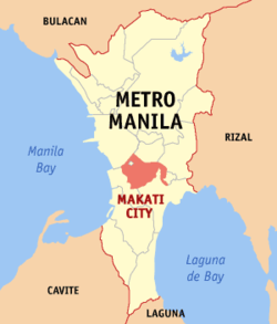
Makati
Guā-māu
| Makati | |
 |
|
| Keng-hūi-tō͘: 14°33′N 121°02′E / 14.550°N 121.033°E | |
| Kok-ka | Hui-li̍p-pin |
|---|---|
| Chèng-hú | |
| - Chhī-tiúⁿ | Mar-Len Abigail "Abby" S. Binay-Campos (UNA) |
| Bīn-chek | |
| - Lóng-chóng | 21.73 km2 |
| Jîn-kháu | |
| - Lóng-chóng | 582,602 lâng |
| - Bi̍t-tō͘ | 27,000/km2 |
| Sî-khu | PHT (UTC+8) |
| Bāng-chām | http://www.makati.gov.ph/ |
Makati (Tagalog: Lungsod ng Makati; iā-ū hoan-e̍k chò Má-ka-tì) sī Hui-li̍p-pin ê siâⁿ-chhī.
Barangay
[siu-kái | kái goân-sí-bé]| Barangay | Population (2004) | Population (2010)[1] | Area (km2) | District |
|---|---|---|---|---|
| Bangkal | 22,433 | 23,378 | 0.74 | 1st |
| Bel-Air | 9,330 | 18,280 | 1.71 | 1st |
| Carmona | 3,699 | 3,096 | 0.34 | 1st |
| Cembo | 25,815 | 27,998 | 0.22 | 2nd |
| Comembo | 14,174 | 14,433 | 0.27 | 2nd |
| Dasmariñas | 5,757 | 5,654 | 1.90 | 1st |
| East Rembo | 23,902 | 26,433 | 0.44 | 2nd |
| Forbes Park | 3,420 | 2,533 | 2.53 | 1st |
| Guadalupe Nuevo | 22,493 | 18,271 | 0.57 | 2nd |
| Guadalupe Viejo | 13,632 | 16,411 | 0.62 | 2nd |
| Kasilawan | 6,224 | 5,291 | 0.09 | 1st |
| La Paz | 8,843 | 7,931 | 0.32 | 1st |
| Magallanes | 7,509 | 5,576 | 1.20 | 1st |
| Olympia | 20,172 | 21,270 | 0.44 | 1st |
| Palanan | 16,614 | 17,283 | 0.65 | 1st |
| Pembo | 35,035 | 44,803 | 1.23 | 2nd |
| Pinagkaisahan | 6,186 | 5,804 | 0.16 | 2nd |
| Pio del Pilar | 22,495 | 27,035 | 1.20 | 1st |
| Pitogo | 13,367 | 15,332 | 0.14 | 2nd |
| Poblacion | 8,446 | 17,120 | 0.46 | 1st |
| Rizal | 37,022 | 41,959 | 3.55 | 2nd |
| San Antonio | 12,226 | 11,443 | 0.89 | 1st |
| San Isidro | 8,686 | 7,589 | 0.50 | 1st |
| San Lorenzo | 6,487 | 10,006 | 2.09 | 1st |
| Santa Cruz | 7,419 | 7,440 | 0.47 | 1st |
| Singkamas | 6,226 | 7,426 | 0.13 | 1st |
| South Cembo | 13,570 | 14,672 | 0.20 | 2nd |
| Tejeros | 16,820 | 13,868 | 0.29 | 1st |
| Urdaneta | 3,817 | 3,717 | 0.74 | 1st |
| Valenzuela | 5,908 | 7,261 | 0.24 | 1st |
| West Rembo | 28,889 | 28,406 | 0.55 | 2nd |
| Pún bûn-chiuⁿ sī chi̍t phiⁿ phí-á-kiáⁿ. Lí thang tàu khok-chhiong lâi pang-chō͘ Wikipedia. |
- ↑ "2010 Census of Population and Housing: National Capital Region" (PDF). National Statistics Office of the Republic of the Philippines. goân-loē-iông (PDF) tī 15 November 2012 hőng khó͘-pih. 12 June 2012 khòaⁿ--ê.