VAST 2011. The 12th International Symposium on Virtual Reality, Archaeology and Cultural Heritage curate by M. Dellepiane, F. Niccolucci, S. Pena Serna, H. Rushmeier & L. Van Gool
In this contribution we describe tools and methods used to perform three-dimensional photogrammet... more In this contribution we describe tools and methods used to perform three-dimensional photogrammetric survey of
different archaeological contexts. In particular, we studied in depth some aspects: swiftness (of the proceeding),
accuracy (of the measurement), informative contents (of the registration) and cost (of the instruments).
Considering these factors we propose some solutions for the integration of photomodelling and
stereophotogrammetry within the current standards of archaeological documentation. The first part will show
three-dimensional photomodelling examples of walls stratigraphy and structural elements. Then follows the
comparative analysis of two different technique of survey for the documentation of the same archaeological
context: the direct detection and the stereophotogrammetric one of a burial. The second part discusses the first
results of an experiment still in progress: the documentation of all the contexts identified during an
archaeological excavation by stereo-detection. The contribution closes with an experience of photogrammetric
survey of petroglyphs
 Bookmarks Related papers MentionsView impact
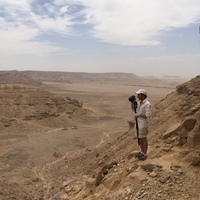
Uploads
Papers
and related activities. We will demonstrate the advantages that a conscious employment of
techniques and methods, together with the right expertise, could offer to an exhibition. We will
detail the steps we took to produce a 1:1 copy of a medieval sphinx for the exhibition Echoes
of Egypt: Conjuring the Land of the Pharaohs which took place at the Yale Peabody Museum
of Natural History (USA). This paper highlights the project’s workflow, from the digital 3D
scan, data processing, 3D printing, to the artistic finishing to prepare the object for display.
Considering these factors we propose some solutions for the integration of photomodelling and stereophotogrammetry within the current standards of archaeological documentation. The first part will show three-dimensional photomodelling examples of walls stratigraphy and structural elements. Then follows the comparative analysis of two different technique of survey for the documentation of the same archaeological context: the direct detection and the stereophotogrammetric one of a burial. The second part discusses the first results of an experiment still in progress: the documentation of all the contexts identified during an archaeological excavation by stereo-detection. The contribution closes with an experience of photogrammetric survey of petroglyphs.
University of Bologna, has investigated a series of sites in the area between Aswan and Kom Ombo, Egypt. The conservation
of the numerous rock art sites identified in this zone is endangered by farming, quarrying, and other business
activities. Recent expeditions have focused their research and methodologies mainly upon the study of rock art and have, as
a consequence, developed an integrated work plan based principally upon a model that encompasses the three dimensions.
Using this model, researchers employ topographic relief maps, scans, and photogrammetry to carry out all aspects of data
recording and analysis. Study methodology has thus developed along three main approaches: the detection of rock art sites
within the project’s mapped areas, the investigation of the geomorphological context of such sites, and the objective study
of the designs and inscriptions themselves.
different archaeological contexts. In particular, we studied in depth some aspects: swiftness (of the proceeding),
accuracy (of the measurement), informative contents (of the registration) and cost (of the instruments).
Considering these factors we propose some solutions for the integration of photomodelling and
stereophotogrammetry within the current standards of archaeological documentation. The first part will show
three-dimensional photomodelling examples of walls stratigraphy and structural elements. Then follows the
comparative analysis of two different technique of survey for the documentation of the same archaeological
context: the direct detection and the stereophotogrammetric one of a burial. The second part discusses the first
results of an experiment still in progress: the documentation of all the contexts identified during an
archaeological excavation by stereo-detection. The contribution closes with an experience of photogrammetric
survey of petroglyphs