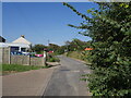
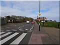
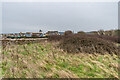
Other tags: Beach Road
Showing images tagged with road:Beach Road tag.

|
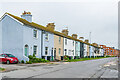
Beach Road and Atlantic Court
by Ian Capper geograph for square TQ2104 Houses on Beach Road with Atlantic Court on Ferry Road on the right, viewed from... (more)
Tags:
building:Atlantic CourtX
road:Beach Road
road:Ferry RoadX
type:GeographX
top:Housing, DwellingsX
place:ShorehamX
place:Shoreham BeachX
place:Shoreham by SeaX
top:Suburb, Urban FringeX
|

|
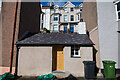
24 Beach Road
by Ian Capper geograph for square TQ2104 The rear of 24 Beach Road as seen from the beach. Note what would appear to be... (more)
Tags:
road:Beach Road
type:GeographX
top:Housing, DwellingsX
ObservatoryX
place:ShorehamX
place:Shoreham BeachX
place:Shoreham by SeaX
top:Suburb, Urban FringeX
|

|
South along Beach Road, Southerndown
by Jaggery geograph for square SS8873 From the B4524, the main road through Southerndown, Beach Road leads to the... (more)
|
|
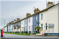
Beach Road
by Ian Capper for square TQ4501 Mainly late 19th Century terraced housing on Beach Road, first marked on the... (more)
Tags:
road:Beach Road
type:Cross GridX
top:Housing, DwellingsX
place:NewhavenX
top:Suburb, Urban FringeX
|
|
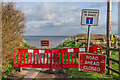
Beach Road
by Ian Capper for square TG3830 Barriers across Beach Road, a road truncated by cliff erosion beyond. Compare... (more)
Tags:
road:Beach Road
Cliff ErosionX
type:Close LookX
place:HappisburghX
Road ClosedX
Road ClsoedX
top:Roads, Road TransportX
top:Village, Rural SettlementX
|
|
Road to the beach, Southerndown
by Jaggery geograph for square SS8873 Looking to the south along Beach Road in Southerndown.
|
|
Beach Road
by Ian Capper geograph for square SY4989 Road connecting Burton Bradstock and Hive Beach.
Tags:
road:Beach Road
place:Burton BradstockX
type:GeographX
top:Housing, DwellingsX
top:Village, Rural SettlementX
|

|
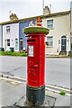
Postbox topper, pillar box, Beach Road
by Ian Capper for square TQ4501 An Easter themed postbox topper on a pillar box in Beach Road - see TQ4501 : Pillar box, Beach Road.
Tags:
road:Beach Road
type:Close LookX
top:CommunicationsX
place:NewhavenX
PillarboxX
Postbox TopperX
top:Suburb, Urban FringeX
|
|
Pillar box, Beach Road
by Ian Capper for square TQ4501 Pillar box in Beach Road, adorned by a postbox topper - see TQ4501 : Postbox topper, pillar box, Beach Road for a... (more)
Tags:
road:Beach Road
type:Close LookX
top:CommunicationsX
place:NewhavenX
PillarboxX
Postbox TopperX
top:Suburb, Urban FringeX
|
|
Beach Road
by Ian Capper for square TQ4401 Mainly late 19th Century terraced housing on Beach Road, first marked on the... (more)
Tags:
road:Beach Road
type:Cross GridX
top:Housing, DwellingsX
place:NewhavenX
top:Suburb, Urban FringeX
|
|
Beach Road houses
by Ian Capper geograph for square TG3830 Looking across a field to the rear of houses in Beach Road.
Tags:
road:Beach Road
type:GeographX
place:HappisburghX
top:Housing, DwellingsX
top:Village, Rural SettlementX
|
|
The Ferryman's Cottage, Beach Road, Menai Bridge
by Oliver Mills geograph for square SH5571 The "restoration" of the quite famous cottage on Beach Road appears to... (more)
Tags:
road:Beach Road
subject:CottageX
Ferrymans CottageX
type:GeographX
top:Housing, DwellingsX
place:Menai BridgeX
top:Village, Rural SettlementX
|

|
Beech Road
by Ian Capper geograph for square TQ2159 Cul-de-sac off Burgh Heath Road. These houses first appear on the 1895-6 1:2500... (more)
Tags:
road:Beach Road
road:Beech RoadX
place:EpsomX
type:GeographX
top:Housing, DwellingsX
top:Suburb, Urban FringeX
|
|
Heading inland on Beach Road
by David Pashley geograph for square TG3830 Tags:
road:Beach Road
top:CoastalX
type:GeographX
subject:RoadX
top:Roads, Road TransportX
top:Village, Rural SettlementX
|
|
Beach Road Mundesley
by David Pashley geograph for square TG3136 Tags:
road:Beach Road
type:GeographX
top:LowlandsX
subject:RoadX
top:Roads, Road TransportX
top:Sport, LeisureX
top:Village, Rural SettlementX
|
|
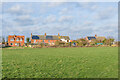
Field corner
by Ian Capper geograph for square SY4989 Field corner south of Burton Bradstock. The houses in the background are in Beach Road.
|
|
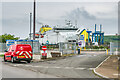
Entrance to Newhaven Port
by Ian Capper geograph for square TQ4500 Entrance to Newhaven Port off Beach Road. In the background is the ferry MS... (more)
Tags:
road:Beach Road
ship:Cote DAlbatreX
top:Docks, HarboursX
type:GeographX
place:NewhavenX
place:Newhaven PortX
|
|
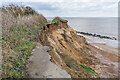
Cliff erosion
by Ian Capper geograph for square TG3830 Looking along a section of rapidly eroding cliffs at Happisburgh. The tarmac in... (more)
|

|
Cliff erosion
by Ian Capper geograph for square TG3830 Looking down on an area of cliff fall below the rapidly eroding cliffs at... (more)
|
|
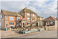
The Ship Inn
by Ian Capper geograph for square TG3136 Pub on Beach Road claiming to be over 300 years old.
Tags:
road:Beach Road
top:Business, Retail, ServicesX
type:GeographX
place:MundesleyX
PubX
pub:ShipX
pub:Ship InnX
top:Village, Rural SettlementX
|

|
Solent Landing
by Ian Capper geograph for square SZ6488 Development of town houses on Beach Road, built in the 1990s on the site of the... (more)
Tags:
road:Beach Road
place:BembridgeX
type:GeographX
top:Housing, DwellingsX
building:Solent LandingX
hotel:Spithead HotelX
top:Village, Rural SettlementX
|