Showing images tagged with place:Cardross tag.

|
Cardross Old Parish Church
by Lairich Rig geograph for square NS3477 Category: Church For further information, see NS3477 : Cardross Old Parish Church, which shows the front of the same... (more)
Tags:
period:19th CenturyX
place:Cardross
Cardross Old Parish ChurchX
former:ChurchX
architect:James DempsterX
top:Religious SitesX
ToponymyX
|

|
Moore's Bridge
by Lairich Rig geograph for square NS3477 Category: Bridge As explained at NS3477 : Moore's Bridge - an original stone, with coat of arms, this is not the original Moore's Bridge, but a... (more)
Tags:
period:19th CenturyX
Auchenfroe BurnX
BridgeX
place:Cardross
Moores BridgeX
Road BridgeX
top:Roads, Road TransportX
|

|
Cardross Old Parish Church
by Lairich Rig geograph for square NS3477 Category: Church See NS3477 : Cardross Old Parish Church for a wider view, on a day with better lighting. Click on the... (more)
Tags:
period:19th CenturyX
place:Cardross
Cardross Old Parish ChurchX
former:ChurchX
architect:James DempsterX
top:Religious SitesX
|

|
Edmonstone Burial Ground
by Lairich Rig geograph for square NS3477 This is the burial ground of the Edmonstones of Cardross Park (see NS3477 : Braid Drive).... (more)
|

|
Cardross Old Parish Church - stone head (on the right)
by Lairich Rig for square NS3477 Category: Stone carvings See NS3477 : Cardross Old Parish Church. Of the two stone heads mentioned there, this is the one to the... (more)
Tags:
place:Cardross
Cardross Old Parish ChurchX
former:ChurchX
bucket:CloseCropX
top:Religious SitesX
|

|
Cardross Old Parish Church - stone head (on the left)
by Lairich Rig for square NS3477 Category: Stone carvings See NS3477 : Cardross Old Parish Church. Of the two stone heads mentioned there, this is the one to the... (more)
Tags:
place:Cardross
Cardross Old Parish ChurchX
former:ChurchX
bucket:CloseCropX
top:Religious SitesX
|

|
Cardross Old Parish Church
by Lairich Rig geograph for square NS3477 The picture was taken from the other side of the main road.
The church was... (more)
Tags:
period:19th CenturyX
place:Cardross
former:ChurchX
top:Derelict, DisusedX
architect:James DempsterX
top:Religious SitesX
|

|
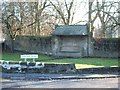
Auchenfroe Family Burial Ground
by Lairich Rig for square NS3477 This structure is located in the kirkyard of NS3477 : Cardross Old Parish Church, and it is almost a... (more)
|

|
Edmonstone Burial Ground (detail)
by Lairich Rig for square NS3477 See NS3477 : Edmonstone Burial Ground for the whole structure, and for more details.
The family... (more)
|

|
Cardross War Memorial
by Lairich Rig geograph for square NS3477 See NS3477 : Cardross War Memorial for another view.
|

|
Braid Drive
by Lairich Rig geograph for square NS3477 Category: Road This is part of the Fairways housing development in Cardross. The houses had... (more)
|

|
Cardross War Memorial
by Lairich Rig geograph for square NS3477 Category: War Memorial See NS3477 : Cardross War Memorial for another view.
|

|
Cardross Parish Church
by Lairich Rig geograph for square NS3477 Category: Church Located on the corner of Church Avenue and Station Road, this former Free... (more)
Tags:
period:19th CenturyX
place:Cardross
Cardross Parish ChurchX
ChurchX
Church (Church of Scotland)X
architect:John Burnet (Senior)X
top:Religious SitesX
|

|
Peel Street, Cardross
by Barbara Carr geograph for square NS3477 Just west of the Coach House Inn, opposite the clubhouse of Cardross Golf Club.
|

|
The Clubhouse, Cardross Golf Club
by Barbara Carr geograph for square NS3477 Alongside the A814 in the village of Cardross.
Tags:
road:A814X
place:Cardross
ClubhouseX
top:Roads, Road TransportX
top:Sport, LeisureX
top:Village, Rural SettlementX
|

|
Bainfield Road, Cardross
by Barbara Carr geograph for square NS3476 Housing at the southeastern edge of Cardross village.
Tags:
road:Bainfield RoadX
place:Cardross
top:Housing, DwellingsX
top:Roads, Road TransportX
top:Village, Rural SettlementX
|

|
Main Road through Cardross
by Lairich Rig geograph for square NS3477 NS3477 : The Muirholm Hotel (NS3477 : The Muirholm, Cardross) is in the background, on the right.
The stone visible... (more)
|

|
Main road through Cardross
by Lairich Rig geograph for square NS3477 This picture was taken with the Domesday Reloaded project in mind, and was an... (more)
|

|
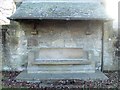
Moore's Bridge - an original stone, with coat of arms
by Lairich Rig for square NS3477 Category: Coat of Arms This grey stone was part of a bridge, which, as the date suggests, was built in... (more)
Tags:
period:17th CenturyX
place:Cardross
bucket:CloseupX
top:Historic Sites and ArtefactsX
Moores BridgeX
|

|
East of Cardross
by Barbara Carr geograph for square NS3576 The A814 runs by rough grazing land east of Cardross, with a view across the... (more)
Tags:
road:A814X
place:Cardross
river:ClydeX
road:Craigend RoadX
top:Farm, Fishery, Market GardeningX
top:GrasslandX
top:Rivers, Streams, DrainageX
top:Roads, Road TransportX
top:Village, Rural SettlementX
|

|
Old Parish Church, Cardross
by Barbara Carr geograph for square NS3477 |

|
Old milestone in Cardross
by Lairich Rig for square NS3477 Category: Milestone This milestone is shown on the first edition of the 1:10560 OS map, surveyed in... (more)
|

|
Platform at Cardross Railway Station
by Lairich Rig geograph for square NS3477 Category: Railway station For more details of this station, see: NS3477 : Cardross Railway Station.
Just beyond the... (more)
|

|
Moore's Bridge - an original stone, with inscription
by Lairich Rig for square NS3477 Category: Inscription "Not we but GOD - Jean Watson"
This is one of two stones that were... (more)
Tags:
period:17th CenturyX
place:Cardross
bucket:CloseupX
top:Historic Sites and ArtefactsX
Moores BridgeX
|

|
The Coach House Inn, Cardross
by Barbara Carr geograph for square NS3477 Opposite the golf club, on the A814 travelling northwestward to the village centre.
Tags:
road:A814X
top:Business, Retail, ServicesX
place:Cardross
public house:Coach House InnX
top:Roads, Road TransportX
top:Village, Rural SettlementX
|

|
Station Road and Villafield Court
by Barbara Carr geograph for square NS3477 Looking towards the Clyde, in the village of Cardross.
Tags:
place:Cardross
top:Housing, DwellingsX
road:Station RoadX
road:Villafield CourtX
top:Village, Rural SettlementX
|

|
Craigend Road
by Barbara Carr geograph for square NS3577 Walking down the hill from Walton to Cardross, with a view over the Clyde... (more)
Tags:
place:Cardross
river:ClydeX
road:Craigend RoadX
top:Housing, DwellingsX
top:Roads, Road TransportX
top:Village, Rural SettlementX
|

|
Bainfield Road, Cardross 2
by Barbara Carr geograph for square NS3476 See also NS3476 : Bainfield Road, Cardross.
Tags:
road:Bainfield RoadX
place:Cardross
top:Housing, DwellingsX
top:Roads, Road TransportX
top:Village, Rural SettlementX
|

|
Cardross and the River Clyde from the air
by Thomas Nugent for square NS3578 Port Glasgow can be seen on the south bank. Viewed from a Glasgow bound flight... (more)
Tags:
Aerial PhotographX
place:Cardross
top:Estuary, MarineX
top:Farm, Fishery, Market GardeningX
top:Sport, LeisureX
top:Village, Rural SettlementX
|

|
Barrs Road, Cardross
by Lairich Rig geograph for square NS3478 Category: Street For a view from further ahead, see NS3478 : Barrs Road, Cardross. On the name, see NS3478 : Barrs Road.
Tags:
place:Cardross
top:Housing, DwellingsX
top:Roads, Road TransportX
weather:SnowX
top:Suburb, Urban FringeX
season:WinterX
|

|
Muirend Road, Cardross
by Lairich Rig geograph for square NS3477 Category: Street The photograph was taken from the western end of the street, at the junction... (more)
Tags:
place:Cardross
top:Housing, DwellingsX
top:Roads, Road TransportX
weather:SnowX
top:Suburb, Urban FringeX
season:WinterX
|

|
Barrs Terrace, Cardross
by Lairich Rig geograph for square NS3477 Category: Street The photograph was taken from the junction with NS3478 : Barrs Road, Cardross.
Tags:
place:Cardross
top:Housing, DwellingsX
top:Roads, Road TransportX
weather:SnowX
top:Suburb, Urban FringeX
season:WinterX
|
|
|
Barrs Terrace and Barrs Road, Cardross
by Lairich Rig geograph for square NS3477 Category: Panorama Barrs Terrace is on the left. For the individual streets, see NS3477 : Barrs Terrace, Cardross and NS3478 : Barrs Road, Cardross.
|

|
Barrs Road, Cardross
by Lairich Rig geograph for square NS3478 Category: Street Ahead, at the entrance gate of a driveway, Kirkton Road branches off to the... (more)
Tags:
place:Cardross
top:Housing, DwellingsX
top:Roads, Road TransportX
weather:SnowX
top:Suburb, Urban FringeX
season:WinterX
|

|
Kilmahew Avenue, Cardross
by Lairich Rig geograph for square NS3478 Category: Street The photograph was taken from the western end of the street, at its junction... (more)
Tags:
place:Cardross
top:Housing, DwellingsX
top:Roads, Road TransportX
weather:SnowX
top:Suburb, Urban FringeX
season:WinterX
|
|
Rural Seat
by Lairich Rig geograph for square NS3477 Category: Seats Shown here is A. N. Paterson's "Rural Seat", which dates from... (more)
Tags:
period:20th CenturyX
architect:A N Paterson & StoddartX
architect:Alexander Nisbet PatersonX
place:Cardross
architect:Donald McKay StoddartX
Scottish Womens Rural InstituteX
SeatX
top:Suburb, Urban FringeX
|

|
Moore's Bridge (oblique view)
by Lairich Rig geograph for square NS3477 Category: Bridge See: NS3477 : Moore's Bridge.
Tags:
period:19th CenturyX
Auchenfroe BurnX
BridgeX
place:Cardross
Moores BridgeX
Road BridgeX
top:Roads, Road TransportX
|

|
The Muirholm Hotel
by Lairich Rig geograph for square NS3477 For detail, see William Craig's earlier photograph: NS3477 : The Muirholm, Cardross.
When the... (more)
|

|
Doorway of old parish church
by Barbara Carr for square NS3477 |

|
Plaque on the Napier Stone
by Barbara Carr for square NS3477 |

|
Old drinking fountain
by Lairich Rig geograph for square NS3477 The old fountain is dated 1902, and bears an ER monogram (for Edward VII).... (more)
|

|
Geilston Halls
by Lairich Rig for square NS3478 Category: Building Built from 1889-90 (Honeyman and Keppie), this building is used for various... (more)
Tags:
period:19th CenturyX
place:Cardross
architect:Honeyman & KeppieX
architect:John HoneymanX
architect:John KeppieX
top:Public Buildings and SpacesX
|

|
Old drinking fountain
by Lairich Rig for square NS3477 Category: Drinking fountain This fountain stands beside Main Road, immediately to the south-east of the War... (more)
|
|
Rural Seat
by Lairich Rig for square NS3477 Category: Seats The seat is shown in context, with further details, here: NS3477 : Rural Seat.
Note,... (more)
Tags:
period:20th CenturyX
architect:A N Paterson & StoddartX
architect:Alexander Nisbet PatersonX
place:Cardross
bucket:CloseCropX
architect:Donald McKay StoddartX
Scottish Womens Rural InstituteX
SeatX
top:Suburb, Urban FringeX
|