Tag: Limestone·Wall
Showing latest 50 of 75 images tagged with Limestone Wall tag.
|
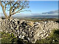
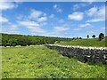
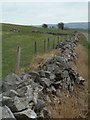
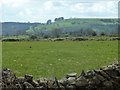
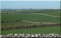
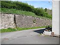
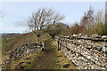
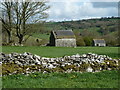
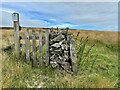
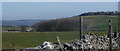
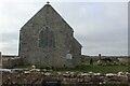
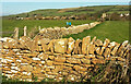
Wall corner, Hampsfell
by Adrian Taylor geograph for square SD4079 The drystone wall marks the southwest corner of Bishops or Tithe Allotment near... (more)
Tags:
top:Boundary, BarrierX
Corner of Dry Stone WallX
Drystone Wall (Limestone)X
type:GeographX
near:Grange-Over-SandsX
HampsfellX
building material:LimestoneX
Limestone UplandX
Limestone Wall
top:UplandsX
subject:WallX
Wall CornerX
|
|
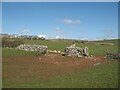
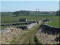
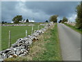
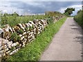
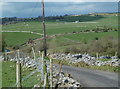
Gateways near Holme Bank
by Adrian Taylor geograph for square SD2773 Birkrigg Common is in the centre background.
Tags:
Birkrigg CommonX
top:Boundary, BarrierX
CumbriaX
Dry Stone WallX
Dry Stone Wall with GateX
Dry Stone Wall with GatewayX
Dry Stone WallingX
Drystone Wall (Limestone)X
top:Farm, Fishery, Market GardeningX
Gate in Dry Stone WallX
GatepostX
subject:GatewayX
Gateway in Dry Stone WallX
type:GeographX
top:GrasslandX
HedgeX
building material:LimestoneX
Limestone Wall
MudX
Stone GatepostX
|
|
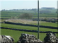
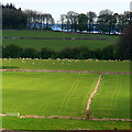
Limestone walls
by David Lally geograph for square SK1559 Near Biggin from an embankment on the Tissington Trail.
Tags:
Drystone Wall (Limestone)X
type:GeographX
Grass FieldsX
Grassy FieldX
Limestone WallsX
top:UplandsX
subject:WallX
|
|
Limestone walls country
by Andrew Hill geograph for square SK1465 The small fields divided by limestone walls are a feature of the countryside... (more)
|
|
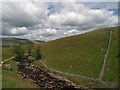
The valley of Whale Beck
by Adrian Taylor geograph for square NY5221 Cragside Wood is in the background and Whale Beck crosses the bottom of the... (more)
|
|
Small fields and limestone walls near Monyash
by Andrew Hill geograph for square SK1466 A footpath cutting a corner with a gap stile in the foreground, many more... (more)
|
|
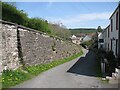
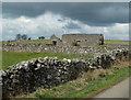
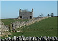
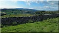
Stone wall on Hampsfell
by Adrian Taylor geograph for square SD4079 This substantial limestone dry stone wall forms the western boundary of Bishops... (more)
Tags:
top:Boundary, BarrierX
Dry Stone WallX
type:GeographX
near:Grange-Over-SandsX
HampsfellX
top:Heath, ScrubX
Limestone Wall
top:Rocks, Scree, CliffsX
Rough PastureX
top:UplandsX
subject:WallX
|
|
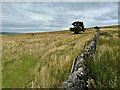
A limestone wall with a lonely hawthorn
by David Lally geograph for square SK1873 On the western edge of Longstone Moor.
|
|
Dry stone wall by the lane to Wheston
by Andrew Hill geograph for square SK1277 An old limestone wall by the lane with a fence as back up.
|
|
Hutmoor Butts (track) towards barn and track junction
by Andrew Hill geograph for square SK1467 A walled track through limestone grazing country near Monyash.
|
|
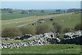
Patterns of fields north of Monyash
by Andrew Hill geograph for square SK1467 The limestone grazing land is typically divided by dry stone walls. The top end... (more)
|
|
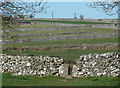
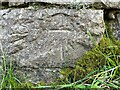
Benchmark, Limekiln Bridge, Bothel
by Adrian Taylor for square NY1839 Detail of the Ordnance Survey cut benchmark on the limestone parapet of Limekiln... (more)
|
|
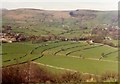
Upland pasture above Ible
by Andrew Hill geograph for square SK2557 Limestone walls and green fields, typical of Derbyshire White Peak uplands.
|
|
Looking up Leys Lane
by Andrew Hill geograph for square SK2657 View up the gentle slopes, with typical upland grazing and limestone walls.
|
|
Hillside fields between Bonsall and Slaley
by Andrew Hill geograph for square SK2757 Typical limestone grazing scene with dry stone walls. Blackthorn in bloom.
|
|
Start of the farm track to Nursery Fields Farm
by Andrew Hill geograph for square SK1567 The farm is a long way back from Horse Lane in an area of grazing land with... (more)
|
|
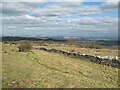
Open grazing land near Monyash
by Andrew Hill geograph for square SK1667 Gentle upland slopes above steep limestone valleys not too far away.
|
|
Limestone wall, Danielswell Farm
by Derek Harper geograph for square ST9287 The lane up from Westport Bridge to the farm is followed by MALW30.
|
|
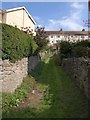
Back path off Chatto Road, Torquay
by Derek Harper geograph for square SX9165 Never really noticed this before; a grassy path leads away between limestone... (more)
|
|
Limestone walls
by Steve Fareham geograph for square SD6975 Near to Ravenray bridge on the Ingleton waterfall walk.
|
|
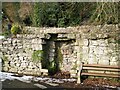
Charney Well
by Adrian Taylor for square SD4078 The well is located a few feet behind the alcove in the limestone wall in what... (more)
Tags:
top:Boundary, BarrierX
type:Close LookX
CumbriaX
Drinking TroughX
Grange-Over-SandsX
place:Grange-Over-SandsX
top:Historic Sites and ArtefactsX
Limestone Wall
Old Water TroughX
Stone AlcoveX
subject:TroughX
WellX
|
|
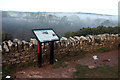
Information board, St Michael's chapel
by Derek Harper geograph for square SX9065 This recent installation, mentioned under SX9065 : Observatory beside St Michael's chapel, provides interesting... (more)
Tags:
top:Air, Sky, WeatherX
top:Boundary, BarrierX
type:GeographX
top:Historic Sites and ArtefactsX
Information BoardX
Limestone Wall
MistX
top:Suburb, Urban FringeX
TreesX
|
|
Fern Dale
by Andrew Hill geograph for square SK1565 View across the limestone valley from the end of Milkings Lane.
|
|
Castleton from the road to Pindale
by M J Richardson geograph for square SK1582 Category: Farmland A view over the flat valley of the Peakshole Water, with small fields bounded by... (more)
Tags:
CastletonX
place:DerbyshireX
top:Farm, Fishery, Market GardeningX
top:GrasslandX
LandscapeX
Limestone WallsX
place:Peak DistrictX
Peakshole WaterX
|
|
The Cumbria Way, Hodden Croft
by Adrian Taylor geograph for square NY3239 This is where The Cumbria Way divides, the main route goes up the steps through... (more)
Tags:
top:Boundary, BarrierX
CaldbeckX
Cumbria WayX
stile:Gap in Stone WallX
Gap in WallX
type:GeographX
Limestone Wall
Minor Village RoadX
top:PathsX
top:Roads, Road TransportX
Steps in WallX
long distance path:The Cumbria WayX
ldp:The Cumbria WayX
The Cumbria WayX
The Cumbria Way Alternative RouteX
top:Village, Rural SettlementX
subject:WallX
|
|
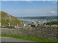
Llandudno Bay
by Alan Murray-Rust for square SH7982 The view from St Beuno's Road on the Great Orme.
|
|
The Cumbria Way, Hodden Croft
by Adrian Taylor geograph for square NY3239 The main route of The Cumbria Way ascends the steps in the narrow gap in the... (more)
Tags:
top:Boundary, BarrierX
CaldbeckX
Cumbria WayX
Cumbria Way Alternative RouteX
Gap in WallX
type:GeographX
Limestone Wall
top:Roads, Road TransportX
The Cumbria WayX
long distance path:The Cumbria WayX
ldp:The Cumbria WayX
The Cumbria Way Alternative RouteX
top:Village, Rural SettlementX
subject:WallX
|
|
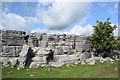
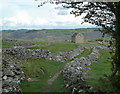
Limestone monoliths, Malham Cove
by Bill Harrison geograph for square SD8964 |
|
Leyburn Shawl approaching Warren Wood
by Chris Heaton geograph for square SE0991 The footpath follows the edge of Leyburn Shawl, a limestone shelf that grants... (more)
|
|
Limestone uplands near Newhaven
by David Lally for square SK1661 |
|
Countryside north of Ible
by Andrew Hill geograph for square SK2457 View from Grange Lane over rolling hillsides with limestone grazing land.
|
|
Old barn by Leys Lane
by Andrew Hill geograph for square SK2557 Upland limestone grazing country on a day with developing spring showers.
|
|
Field barns near Slaley
by Andrew Hill geograph for square SK2757 Limestone grazing country scene - it always looks wonderful in the spring.
|
|
Monyash view
by Andrew Hill geograph for square SK1566 View over the village as approaching along Milkings Lane, the Limestone Way.
|
|
Field and ruined barn
by Andrew Hill geograph for square SK1767 An old limestone field barn north of the lane, near Magpie Mine.
|
|
Steps in Malmesbury
by Derek Harper geograph for square ST9387 A reverse view of ST9387 : Steps in Malmesbury, looking up the steps (public footpath MALM22)... (more)
|
|
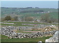
Gate to Longstone Moor
by David Lally for square SK1873 The wall has long since disappeared but the gate remains. The small sign marks... (more)
|
|
Trees and wall near Broadhurst Farm
by David Lally geograph for square SK0949 |
|
Cop Farm
by Stephen Burton geograph for square SK1279 Cop Farm can be seen in the top left of the photograph.
Tags:
Dry Stone WallsX
FarmlandX
Limestone WallsX
season:SummerX
top:UplandsX
top:Village, Rural SettlementX
|
|
Walled path and field barn near Middleton
by Andrew Hill geograph for square SK2856 The path heads to the edge of Dene Quarry beyond the barn.
|
|
Fields above Lathkill Dale
by Andrew Hill geograph for square SK1665 View from the point where the footpath crosses the wall when heading towards One... (more)
|
|
Pennine bridleway sign and drystone wall
by Steve Fareham geograph for square SD8365 Tags:
Limestone WallsX
top:PathsX
Pennine BridlewayX
top:Sport, LeisureX
top:UplandsX
Yorkshire DalesX
|
|
Dry stone wall and view towards Ingleborough
by Steve Fareham geograph for square SD8365 From the minor road from Langcliffe.
|
|
Lambton family vault, Flimston chapelyard
by M J Roscoe geograph for square SR9295 The vault is enclosed by erratics; the plaques on the four stones carry the... (more)
|
|
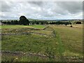
Flimston Chapel, eastern aspect
by M J Roscoe geograph for square SR9295 A medieval chapel converted in the late C18 to a farm outbuilding with two cart... (more)
|
|
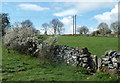
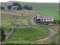
High Hampsfield Farm
by Adrian Taylor geograph for square SD4080 Tags:
top:Boundary, BarrierX
Dry Stone WallX
Edge of WoodX
subject:FarmX
top:Farm, Fishery, Market GardeningX
type:GeographX
LaneX
Limestone Wall
top:PathsX
Public FootpathX
|
|
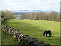
Field near High Hampsfield Farm
by Adrian Taylor geograph for square SD4080 The Coniston Fells are in the background beyond the Cartmel Valley.
Tags:
top:Boundary, BarrierX
Coniston FellsX
county:CumbriaX
Dry Stone WallX
top:Farm, Fishery, Market GardeningX
subject:FieldX
type:GeographX
Grazing HorseX
HorseX
Limestone Wall
PastureX
|
|
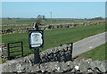
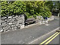
Seat, Grange Fell Road
by Adrian Taylor geograph for square SD4077 Grange Fell Road climbs steeply from Grange town centre and this seat is... (more)
Tags:
top:City, Town CentreX
Cut Bench MarkX
Cut BenchmarkX
type:GeographX
Grange-Over-SandsX
place:Grange-Over-SandsX
Limestone Wall
Public SeatX
subject:SeatX
|
|
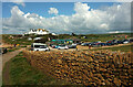
Hive Beach car park
by Derek Harper geograph for square SY4988 The coast path approaches the fast-filling car park alongside an attractive... (more)
Tags:
top:Boundary, BarrierX
top:Business, Retail, ServicesX
CafeX
Car ParkX
CliffX
top:CoastalX
type:GeographX
long distance path:Hardy WayX
HotelX
Limestone Wall
National Trust LandX
top:Roads, Road TransportX
long distance path:South West Coast PathX
top:Sport, LeisureX
VisitorsX
|
|
Walls near Burton Bradstock
by Derek Harper geograph for square SY4889 Just to the left is a junction of the Hardy Way and the coast path (from which... (more)
Tags:
Dog-WalkersX
top:Farm, Fishery, Market GardeningX
FarmlandX
type:GeographX
HillX
Limestone WallsX
top:LowlandsX
top:PathsX
top:Religious SitesX
long distance path:South West Coast PathX
top:Sport, LeisureX
gate:TimberX
TreesX
VillageX
top:Village, Rural SettlementX
|