|
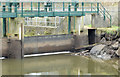
The Stranmillis weir (open), Belfast (February 2015)
by Albert Bridge
geograph for square J3470
The Stranmillis weir gates were raised today allowing the upstream part of the... (more)
|
|
The Stranmillis Weir, Belfast - March 2018(2)
by Albert Bridge
for square J3470
The Stranmillis Weir with two of the gates raised. The Lagan was fast and... (more)
|
|
The Lagan weir, Belfast (21)
by Albert Bridge
for square J3474
|

|
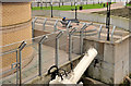
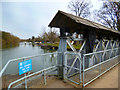
The Stranmillis weir, Belfast (2013-2)
by Albert Bridge
for square J3470
Part of the apparatus used to raise and lower the gates. The makers name... (more)
|
|
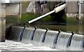
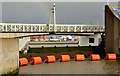
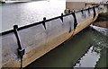
Weir gates on the River Lagan
by Oliver Dixon
geograph for square J3474
These weir gates (five in all) are deployed to ensure that the river upstream is... (more)
|
|
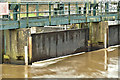
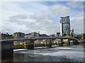
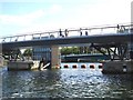
The Lagan Weir, Belfast (November 2015)
by Albert Bridge
geograph for square J3474
The Lagan Weir, about 2½ hours before high water, with all five gates raised (closed).
|
|
Hydraulic ram, Lagan weir, Belfast (July 2015)
by Albert Bridge
geograph for square J3474
One of the hydraulic rams used to operate the Lagan weir gates (second one from... (more)
|
|
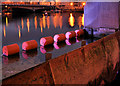
The Lagan weir, Belfast (19)
by Albert Bridge
for square J3474
The Queens Quay side of the Lagan weir, 20 minutes after sunset. The weir gate... (more)
|
|
The Lagan weir, Belfast (11)
by Albert Bridge
for square J3474
Category: Weir
|
|
The Lagan weir, Belfast (2013-3)
by Albert Bridge
geograph for square J3474
The western side of the weir seen from Donegall Quay. At 45 minutes before high... (more)
|
|
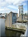
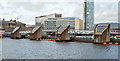
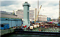
Weir and cross-harbour bridges, Belfast (40)
by Albert Bridge
geograph for square J3474
|
|
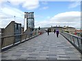
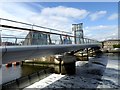
Lagan Weir Footbridge
by Oliver Dixon
geograph for square J3474
The footbridge was built in 2015 to replace a much narrower bridge at this point... (more)
|
|
Lagan Weir Footbridge
by Oliver Dixon
geograph for square J3474
The footbridge was built in 2015 to replace a much narrower bridge at this point... (more)
|
|
Lagan weir and footbridge
by Oliver Dixon
geograph for square J3474
The footbridge was built in 2015 to replace a much narrower bridge at this point... (more)
|
|
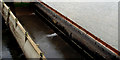
The Lagan weir, Belfast (17)
by Albert Bridge
for square J3474
A raised weir gate at 18 minutes before the time predicted for low water, Belfast.
|
|
The Lagan Weir, Belfast (December 2015)
by Albert Bridge
geograph for square J3474
The eastern side of the Lagan Weir about an hour before high water. The early... (more)
|
|
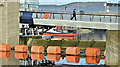
Lagan Weir and Footbridge at high tide
by Oliver Dixon
geograph for square J3474
Water level the same both down- and up-stream.
|
|
Upstream from the Weir
by Des Blenkinsopp
geograph for square SU5097
|
|
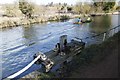
Top of the gate
by Bill Nicholls
geograph for square SU5566
View of the sluice gate along the bank of the Kennet near Cranwell bridge.
|