Tag: Lunesdale
Other tags: place:Lunesdale
Showing images tagged with Lunesdale tag.
|
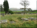
Churchyard at Middleton, in Lunesdale
by M J Richardson geograph for square SD6286 |
|
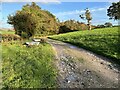
Track near Coulter Beck
by Adrian Taylor geograph for square SD6275 The track to Cowdber Farm is also the route of the public footpath from Nether... (more)
|
|
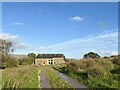
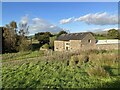
Cowdber Barn
by Adrian Taylor geograph for square SD6275 Cowdber Farm is no longer a working farm and the barn has been converted into... (more)
|
|
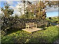
Seat on Woodman Lane
by Adrian Taylor geograph for square SD6175 The installation of this seat in commemoration of the Coronation of King Charles... (more)
Tags:
top:Boundary, BarrierX
CoronationX
Coronation BenchX
type:GeographX
King Charles III CoronationX
LancashireX
top:LowlandsX
Lunesdale
subject:SeatX
Stone WallX
Woodman LaneX
|
|
Cowdber Barn
by Adrian Taylor geograph for square SD6275 Cowdber Farm is no longer a working farm and the barn has been converted into... (more)
Tags:
subject:BarnX
Barn ConversionX
Farm BuildingX
type:GeographX
Holiday AccommodationX
LancashireX
Lunesdale
top:Sport, LeisureX
top:Village, Rural SettlementX
|
|
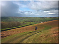
The track above Fellside
by Karl and Ali geograph for square SD6488 As the footpath above Fellside reaches open country the view across the Lune... (more)
|
|
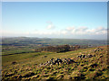
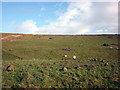
The pasture above Casterton Stone Circle
by Karl and Ali geograph for square SD6479 The circle is located on the flat platform near the far corner of the pasture.... (more)
Tags:
Archaeological SiteX
top:Farm, Fishery, Market GardeningX
top:GrasslandX
place:Lunesdale
Pile of StonesX
Sheep PastureX
Stone CircleX
top:UplandsX
|
|
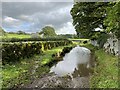
Ford near Burrow Hall
by Adrian Taylor geograph for square SD6176 This ford is on a farm access track between Over Burrow and Leck Beck Barn... (more)
|
|
Casterton Stone Circle
by Karl and Ali geograph for square SD6379 '19 stones all under two feet high forming a circle some 62 feet in... (more)
Tags:
Archeological SiteX
period:Bronze AgeX
top:Derelict, DisusedX
top:GrasslandX
top:Historic Sites and ArtefactsX
place:Lune ValleyX
place:Lunesdale
period:NeolithicX
top:Religious SitesX
Sheep PastureX
Stone CircleX
top:UplandsX
|
|
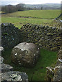
An Andy Goldsworthy sheepfold on Fellfoot Lane
by Karl and Ali geograph for square SD6379 There are 16 of these in total along the lane, each containing a boulder. The... (more)
Tags:
person:Andy GoldsworthyX
Art InstallationX
top:GrasslandX
top:LowlandsX
place:Lune ValleyX
place:Lunesdale
PastureX
top:PathsX
SheepfoldX
top:Sport, LeisureX
|
|
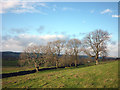
Trees and pasture above Casterton
by Karl and Ali geograph for square SD6379 November afternoon sunshine on the footpath south of Langthwaite.
Tags:
top:Air, Sky, WeatherX
top:Farm, Fishery, Market GardeningX
top:GrasslandX
top:LowlandsX
place:Lune ValleyX
place:Lunesdale
PastureX
top:PathsX
Public FootpathX
TreesX
|