Tag: Loughshore
Showing latest 50 of 201 images tagged with Loughshore tag.

|
The Loughshore Park, Jordanstown (6)
by Albert Bridge geograph for square J3683 See J3683 : The Loughshore Park, Jordanstown (5). The new bandstand, with its jazz band, seen from near the... (more)
|

|
Mussel shells, Jordanstown
by Albert Bridge for square J3683 The commercial exploitation of the mussel beds of Belfast Lough is quite a big... (more)
|

|
Groyne, Jordanstown
by Albert Bridge geograph for square J3683 A long concrete groyne on the loughshore at Jordanstown. This bandstand... (more)
|

|
Sculpture, Jordanstown
by Albert Bridge for square J3683 A new sculpture (beside the Shore Road at the Loughshore Park), still not... (more)
|

|
The Loughshore Park, Jordanstown (7)
by Albert Bridge for square J3683 A close look at some of the musicians seen, from a distance, in J3683 : The Loughshore Park, Jordanstown (6).
|

|
The Loughshore Park, Jordanstown (5)
by Albert Bridge geograph for square J3683 The new bandstand previously seen, under construction, in September 2010 J3683 : The Loughshore Park, Jordanstown (3).
|

|
Telescopes, Jordanstown, Newtownabbey
by Albert Bridge for square J3683 Two recently-provided telescopes, by the loughshore, at Jordanstown. They seem... (more)
|

|
"Tayto" van, Jordanstown
by Albert Bridge for square J3683 A Mercedes box van, at the Loughshore Park, carrying Tayto crisps J0346 : Directional Sign to Tayto Potato Crisp Factory, Tandragee.... (more)
|

|
The Loughshore Park, Jordanstown (8)
by Albert Bridge geograph for square J3683 The old toilets J3683 : The Loughshore Park, Jordanstown (2) have now been replaced by this block which also houses a cafe.
|

|
The loughshore, Mahee Island (2)
by Albert Bridge geograph for square J5263 Another example of the western loughshore of Strangford Lough. The rocky and... (more)
|

|
The loughshore, Holywood (3)
by Albert Bridge geograph for square J4079 The loughshore, looking towards Belfast, seen from the North Down Coastal Path... (more)
|

|
The loughshore near Helen's Bay (2)
by Albert Bridge geograph for square J4482 The loughshore, between Seahill and Helens Bay, about 70 minutes before sunset.... (more)
|

|
The loughshore, Reagh Island near Comber (1)
by Albert Bridge geograph for square J5264 The shore of Strangford Lough, on the eastern side of Reagh Island, about 1¼... (more)
|

|
The Loughshore, Rough Island near Comber (4)
by Albert Bridge for square J4968 The loughshore on the eastern side of Rough Island, where the tides have... (more)
Tags:
Boulder ClayX
top:CoastalX
ComberX
top:Geological InterestX
IslandX
top:IslandsX
Loughshore
Tidal ActionX
|

|
The Loughshore, Newtownards (4)
by Albert Bridge geograph for square J4972 A tidal stream, flowing through Pattons Marsh, beside the sea defences and the... (more)
|

|
The loughshore, Jordanstown/Greenisland (1)
by Albert Bridge geograph for square J3683 A part of the shore of Belfast Lough, well hidden from the Shore Road by housing... (more)
|

|
The loughshore near Comber (12)
by Albert Bridge geograph for square J5165 See J5165 : The Loughshore near Comber (8) (June 2010). The eastern side of the same bay, on Strangford... (more)
|

|
The loughshore, Craigavad
by Albert Bridge geograph for square J4281 The sandy shore of Belfast Lough, about an hour before high water Bangor, close... (more)
|

|
Loughshore, Holywood
by Albert Bridge geograph for square J3878 Rocks, pebbles and sand on the shore at Kinnegar J3878 : The loughshore, Kinnegar, Holywood. The entrance to... (more)
|

|
The loughshore, Kinnegar, Holywood
by Albert Bridge geograph for square J3878 The rocky shore of Belfast Lough (about 80 minutes before low water), at... (more)
|

|
The Loughshore, Helen's Bay (July 2018)
by Albert Bridge geograph for square J4482 The shore of Belfast Lough on what turned out to be the last day in the long... (more)
Tags:
top:Air, Sky, WeatherX
place:Belfast LoughX
CloudsX
top:CoastalX
type:GeographX
place:Helens BayX
Loughshore
subject:ShoreX
ShoreX
|

|
Old brick, Belfast Lough (April 2018)
by Albert Bridge for square J3878 An old brick in the process of being worn smooth by the passing of the tides -... (more)
|

|
The Loughshore, Holywood Banks, Belfast Lough (April 2018)
by Albert Bridge geograph for square J3878 See J3878 : Lagoon near Holywood [1] (July 2008). A bit further north, a small sandy bay close to... (more)
|

|
Loughshore and wind turbine masts, Holywood (May 2017)
by Albert Bridge geograph for square J4079 The shore of Belfast Lough (an hour after low water Belfast), from Seapark,... (more)
Tags:
Belfast HarbourX
place:Belfast LoughX
top:CoastalX
type:GeographX
place:HolywoodX
Loughshore
ShoreX
subject:ShoreX
Wind Turbine MastsX
|

|
Clouds over Strangford Lough
by Albert Bridge geograph for square J5767 The loughshore, about three hours before low water Killyleagh, beside the... (more)
Tags:
top:Air, Sky, WeatherX
CloudsX
top:CoastalX
type:GeographX
place:GreyabbeyX
Loughshore
Strangford LoughX
|

|
Oystercatcher and cockle, Belfast Lough (January 2017)
by Albert Bridge for square J3778 About two hours after low water, an oystercatcher with a freshly-caught cockle,... (more)
Tags:
place:BelfastX
place:Belfast LoughX
BirdX
subject:BirdX
type:Close LookX
top:CoastalX
Loughshore
bird:OystercatcherX
top:Wild Animals, Plants and MushroomsX
|

|
The loughshore at The Floodgates, Newtownards (July 2015)
by Albert Bridge for square J5072 Sand and inter-tidal mud, at the northern end of Strangford Lough, close to The... (more)
Tags:
top:CoastalX
Inter Tidal MudX
Loughshore
MudX
MudflatsX
place:NewtownardsX
SandX
Strangford LoughX
StreamX
|

|
Pied wagtail, Holywood (March 2015)
by Albert Bridge for square J3979 A pied wagtail, by the loughshore, close to The Esplanade.
Tags:
place:Belfast LoughX
BirdX
subject:BirdX
top:CoastalX
place:HolywoodX
Loughshore
bird:Pied WagtailX
WagtailX
top:Wild Animals, Plants and MushroomsX
|

|
The loughshore near Grey Point, Helen's Bay (February 2015)
by Albert Bridge geograph for square J4583 A standard scene on the Co Down side of Belfast Lough, between Coastguard Avenue... (more)
|
|
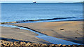
The shore at Helen's Bay (January 2015)
by Albert Bridge geograph for square J4682 Firm sand on the loughshore at Helens Bay, about two hours after high water... (more)
Tags:
BeachX
place:Belfast LoughX
Bulk CarrierX
top:CoastalX
place:Helens BayX
Loughshore
ShipX
Ship at AnchorX
subject:ShoreX
ShoreX
|

|
The Seafront Road, Cultra (September 2014)
by Albert Bridge geograph for square J4180 See J4180 : The Seafront Road, Cultra near Holywood (January 2013). The seaward end of the road, approaching the... (more)
Tags:
place:Belfast LoughX
top:CoastalX
place:CultraX
FerryX
place:HolywoodX
Loughshore
RoadX
top:Roads, Road TransportX
Stena LineX
Stena SuperfastX
|

|
The loughshore, Newtownards (July 2014)
by Albert Bridge geograph for square J5073 The northern shore of Strangford Lough, at Newtownards, about 2½ hours after... (more)
|

|
Steps, Cultra
by Albert Bridge geograph for square J4180 Stone steps leading from the Seafront Road to the loughshore.
|
|
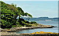
The Loughshore, Helen's Bay (May 2014)
by Albert Bridge for square J4583 The wooded shore of Belfast Lough, between Grey Point J4583 : Grey Point and Helens Bay... (more)
|
|
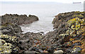
The loughshore, Helen's Bay
by Albert Bridge geograph for square J4583 A small rocky bay, fairly standard for this part of the coastal path, between... (more)
Tags:
BayX
place:Belfast LoughX
top:CoastalX
place:Helens BayX
Loughshore
North Down Coastal PathX
top:PathsX
ShorelineX
|

|
High water, Seapark, Holywood
by Albert Bridge geograph for square J4079 The loughshore, at Seapark, about 30 minutes before high water, four hours... (more)
Tags:
place:Belfast LoughX
top:CoastalX
Full MoonX
High TideX
place:HolywoodX
Loughshore
ShoreX
Spring TideX
Tidal VariationX
TideX
|

|
Rocks and waves, Helen's Bay (3)
by Albert Bridge for square J4482 The incoming tide, along this part of the loughshore J4482 : The North Down coastal path, Helen's Bay, during a brisk... (more)
|

|
Outfall, Belfast Lough (3)
by Albert Bridge geograph for square J4181 An (apparently disused) outfall, on the Helens Bay side of the loughshore, at... (more)
Tags:
place:Belfast LoughX
top:CoastalX
place:CultraX
top:Derelict, DisusedX
Loughshore
OutfallX
Outfall (Disused)X
|

|
Drumlin and loughshore near Comber
by Albert Bridge geograph for square J5064 The view south, into the midday sun, from the end of the Trench Road... (more)
|

|
The low water mark, Cultra (2)
by Albert Bridge geograph for square J4080 Low water Belfast today was at 10.11. This view, in the direction of... (more)
|

|
The low water mark, Cultra (1)
by Albert Bridge geograph for square J4080 Low water Belfast today was at 10.11. This view, towards Belfast harbour at... (more)
|

|
Coastal sandstone, Cultra, Belfast Lough
by Albert Bridge for square J4080 Geology has never been one of my areas of knowledge. I have, however, always... (more)
|

|
Lichen, Crawfordsburn (2013)
by Albert Bridge for square J4682 A white lichen growing on the rocks on the loughshore very close to J4682 : Scurvygrass, Crawfordsburn.
|

|
Scurvygrass, Crawfordsburn
by Albert Bridge for square J4682 This might be common scurvygrass... (more)
|

|
The loughshore, Newtownards (10)
by Albert Bridge geograph for square J4971 The shore, on the western side of Strangford Lough, near this part of the... (more)
|

|
The loughshore, Newtownards (9)
by Albert Bridge geograph for square J4971 The shore of Strangford Lough, near here J4971 : The seawall, Newtownards (5). Its now salt marsh mixed... (more)
|

|
The loughshore, Newtownards (8)
by Albert Bridge geograph for square J4972 Salt marsh on the eastern side of this stretch of seawall J4972 : The seawall, Newtownards (4).
|

|
The loughshore, Newtownards (6)
by Albert Bridge geograph for square J4972 An area of salt marsh, close to the seawall J4972 : The seawall, Newtownards (3), typical of this part of... (more)
|

|
The loughshore near the Blackhead lighthouse, Whitehead
by Albert Bridge geograph for square J4893 Approaching the lighthouse, where the path hugs the bottoms of the... (more)
Tags:
Belfast LoughX
place:Belfast LoughX
top:CoastalX
Coastal PathX
Loughshore
PathX
top:PathsX
ShoreX
place:WhiteheadX
WhiteheadX
|

|
The loughshore, Mahee Island (3)
by Albert Bridge for square J5263 The shore of Strangford Lough, opposite the Nendrum monastic site J5263 : Old monastic site, Nendrum (1), at... (more)
|