near to Ramsbury, Wiltshire, England
Coverage
We have
12 images
in grid square SU2773
Maps
TIP: Click the map for more Large scale mapping
Tip: Click the map to open the coverage map
We have
12 images
for SU2773

|
For Sale: Preston Farm
The Estate agents website quoted:
"Comprising 6.805 hectares (est) - 16.815 acres (est) with the 2 dutch barns.
Guide price £150,000 + Informal tender, unconditional best offers to be received at the agents by 12 noon on 14th... (more)
|

|
Farmland, Aldbourne
by Andrew Smith
The view across and down the valley from above Preston.
|

|
Field above Ramsbury
by AJD
|

|
The Aldbourne at Preston Farm |

|
Farmland, Aldbourne
by Andrew Smith
Stubble fields below Loves Copse.
|
|
Farmland, Aldbourne
by Andrew Smith
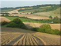
A downland patchwork of stubble, ploughed fields, pastures and woodland in the Aldbourne valley.
|

|
Farmland, Aldbourne
by Andrew Smith
Looking from Loves Copse towards the southern end of the copse on Southward Down.
|

|
Footpath through Love's Copse
by AJD
|
|
Northern edge of Love's Copse
by AJD
As viewed from the public footpath.
|

|
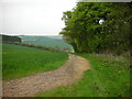
Track, Love's Copse
by AJD
|

|
Track to Crowood Farm, Whittonditch
by David Howard
|

|
Farmland, Ramsbury
by Andrew Smith
With a footpath through wheat to the south of Love's Copse.
|
|