near to Charfield, South Gloucestershire, England
Coverage
We have
14 images
in grid square ST7290
Maps
TIP: Click the map for more Large scale mapping
Tip: Click the map to open the coverage map
We have
14 images
for ST7290

|
Cattle country
Cows grazing peacefully off Little Bristol lane. In the valley in the background is the settlement of Charfield.
|

|
The Gloucester to Bristol line
60 093 heads south with a heavy load of 28 tankers.
|

|
Railway bridge over the B4060
Looking north towards Wotton. The train is heading towards Gloucester.
|
|
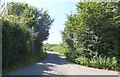
No through road to Southend Farm
by Ruth Riddle
The view from the junction with Little Bristol Lane and Devil's Lane. There are in fact two road signs indicating that this lane is a dead end, but one of them is almost totally obscured by foliage!
|

|
Field near Wickwar
The B4060 makes a brief appearance in this picture as it disappears towards Kingswood.
|

|
Railway bridge over B4060 |

|
Hillside grazing near Uppergreen Farm
by JThomas
|

|
Upper Green Farm, Wickwar
Oil train from Westerleigh north of Wickwar.
|

|
Drive to Newhouse Farm
Farm drive to Newhouse Farm near Charfield, viewed here from Devil's Lane.
|

|
Sheep near Newhouse Farm
Sheep in a field near Newhouse Farm, Charfield.
|

|
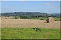
Straw bales in a stubble field
Straw bales in a stubble field to the south of Charfield. Day House Farm can be seen in the middle distance with the Cotswold Hills on the horizon.
|
|
Straw bales in a stubble field
Straw bales in a stubble field near Charfield, the Cotswold Hills can be seen in the distance.
|

|
Solar farm, South Gloucestershire
by Robin Stott
The view west from a Bristol-bound train; location estimated, assisted by the phone. Lots of pylons suggest a location east of the power lines junction in ST7090. The large building on the right may be associated with Wickwar Quarry... (more)
|

|
View from hill near Little Bristol
by don cload
|
|