near to Timble, North Yorkshire, England
Coverage
We have
30 images
in grid square SE1653
Maps
TIP: Click the map for more Large scale mapping
Tip: Click the map to open the coverage map
A sample of 12 photos from 30
for SE1653
- View this square in the Browser >>>

|
Grazing, Sourby New Farm
by JThomas
|
|
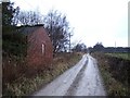
The old lane to Blubberhouses Moor, Great Timble
This is shown as a through road to Bolton Bridge on Thomas Jeffreys's map of 1775. Now it leads to a track over the moor that has been ruined by motor vehicles but has now had a traffic order to prohibit such abuse. The brick... (more)
|
|
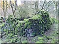
Abandoned Farm at Gill Becks
Disappearing under moss, this old farm complex sticks up in a forest clearing to the side of the footpath heading for Cote Hill.
It has been abandoned for a very long time as I can find no reference to it even on the 1854 1st Series OS... (more)
|

|
Road to Sourby Farm |
|
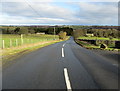
Rues Lane
by Chris Heaton
Part of the road between Otley and Blubberhouses, seen here outside Rues Farm.
|

|
Timble, Sourby Farm
by Mel Towler
The benchmark is cut into the north face of the old farmhouse. It is on the wall where the 5 bar gate is hanging.
|

|
Gates across the unclassified road
This public right of way has been blocked - foot access only is through a small gap to the left. There is a Traffic Regulation Order on this road which applies to cars and motor cycles
|

|
Approaching Lane End
by DS Pugh
This track comes from Sourby Farm and meets Askwith Moor Road ahead.
|

|
Gill Becks
by Mick Garratt
|

|
Forestry Track Great Timble |

|
Road to Gills Beck off Rues Lane |

|
Timble, Rues Lane
by Mel Towler
There is a benchmark cut into the right hand gatepost of this gatehole on the east side of the lane.
|
Explore more images in this square: | View Filtering options | View all 30 images page by page >>> |
|