near to Pendlebury, Salford, England
Coverage
We have
44 images
in grid square SD7900
Maps
TIP: Click the map for more Large scale mapping
Tip: Click the map to open the coverage map
Sample images
Breakdown list
A sample of 12 photos from 44
for SD7900
- View this square in the Browser >>>

|
Church of St John (The Evangelist), Pendlebury
by David Dixon
Bolton Road.
|

|
Irlams o' th' Height
Looking in a southerly direction down Claremont Road in Irlams o' th' Height, Salford. SD79470045
|

|
The East Lancs Road underpass at the junction with the A6 and A666 |

|
Bolton Road, Pendlebury, Looking South |

|
New Barton Street, Irlam o'th' Heights
A view down New Barton Street in the Irlam o'th' Heights area of the City of Salford, in Greater Manchester, England.
|
|
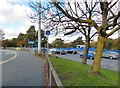
Irlam o th' Height
The traffic on the right is coming off the A6 onto a roundabout that provides access on to the A6 northbound, the A666 and a couple of local roads. Traffic on the A6 for the A580 can continue on the dual carriageway underneath the... (more)
|

|
Agecroft Community Fire Station
Agecroft Community Fire Station at Pendlebury.
|

|
Two pubs on Bolton Road
by Bill Boaden
This used to be the main road before the A6/A580 underpass was built. The two pubs, The Waggon & Horses and The Wellington, belong to Holts, which is reflected in their more modern style. Between them, the half-timbered building used to... (more)
|

|
Lightoaks Park children's playground
A park in Irlams o' th' Height
|

|
Bolton Road
The former A6 through Irlam o'th' Heights now bypassed for non-local traffic by the dual carriageway on the left.
|

|
Aldi store at Irlam o'th' Height
by philandju
Off Bolton Road.
|

|
Footbridge over the A580, Irlams o' th' Height
The footpath was closed when I visited, pedestrians seemed to be using the cycle lanes on the roundabout instead.
|
Explore more images in this square: | View Filtering options | View all 44 images page by page >>> |
|