near to Grizebeck, Cumbria, England
Coverage
We have
12 images
in grid square SD2486
Maps
TIP: Click the map for more Large scale mapping
Tip: Click the map to open the coverage map
We have
12 images
for SD2486

|
Press Beck
From Press Beck Bridge. Just in the southern edge of the square
|

|
Fields and hillside near Heathwaite
by Andrew Hill
|

|
Heathwaite Farm |

|
Heathwaite Farm
by David Brown
|
|
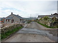
Road at Heathwaite Farm
With a new house being built
|

|
Summit of The Knott
by Karl and Ali
Summit rocks at just over 180m asl. As with many of the low fells hereabouts there is a superb view north of the higher fells.
|

|
Far Houses
by Karl and Ali
There are ruined buildings on both sides of the track which are collapsing and overgrown. It is difficult to tell how many were occupied or if this was just a single farmstead.
|
|
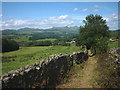
Walled track to Far Houses
by Karl and Ali
Footpath to the abandoned settlement at Far Houses, looking north to the Coniston fells.
|

|
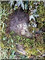
Ordnance Survey Rivet
by Adrian Dust
This OS rivet can be found on the boulder east side of the road. It marks a point 63.731m above mean sea level.
|
|
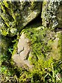
Ordnance Survey Rivet
by Adrian Dust
This OS rivet can be found on the wall east side of Woodlands Road. It marks a point 79.376m above mean sea level.
|
|
Ordnance Survey Rivet
by Adrian Dust
This OS rivet can be found on the wall west side of Woodlands Road. It marks a point 93.637m above mean sea level.
|

|
Modern farm buildings
by P Gaskell
|
|