near to Moira, Co Down, Northern Ireland
Coverage
We have
10 images
in grid square J1659
Maps
Loading map... (JavaScript required)
Tip: Click the map to open the coverage map
We have
10 images
for J1659
|
Newmill Bridge
by Brian Shaw
Over the River Lagan looking upstream.
|
|
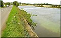
The River Lagan near Moira
This is the River Lagan at the Newmill Bridge on the Clarehill Road near Moira. Much of the surrounding countryside here is flat and the river flows slowly, even after heavy rain. The view is downstream towards Lisburn and Belfast.
|
|
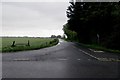
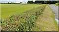
Road Junction
by Robert Ashby
Junction of Clarehill Road and Bottier Road on a gloomy wet spring afternoon near Moira.
|
|
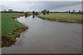
Floods near Moira (1)
See J1659 : The River Lagan near Moira. The heavy rain on 5/6 September caused the Lagan to break its banks in the flat countryside between Moira and the Maze. This is the view downstream, from the Newmill Bridge (the Clarehill Road), south east of Moira.... (more)
|
|
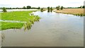
Floods near Moira (2)
See J1659 : Floods near Moira (1). The view along the Clarehill Road, towards Moira, from close to the Newmill Bridge. Some grass is still visible at middle/lower right. Continue to J1860 : Floods near Moira (3).
|
|
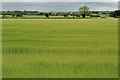
Flat countryside near Moira (1)
Much of the countryside, roughly between Sprucefield and Moira, around the Lagan and the M1 is flat. The OS map shows a few widely-spaced contours. This example is on the northern side of the Bottier Road, between the Clarehill Road and... (more)
|
|
Flat countryside near Moira (2)
See J1659 : Flat countryside near Moira (1). Part of the same field, beside the Bottier Road. The Grovehill Road is at top right.
|
|
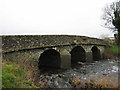
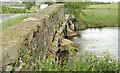
The Newmill Bridge near Moira
A three-arch stone bridge, with concrete-reinforced piers, carrying the Clarehill Road across the River Lagan. Built circa 1740/59. Listed and more information is available here... (more)
|
|
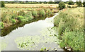
The River Lagan at the Newmill Bridge, Moira - July 2018(1)
The River Lagan, looking downstream, from the Newmill Bridge on the Clarehill Road, during the current long dry spell. There are water lilies growing and the riverbed is visible. For a seasonal comparison in water level see J1659 : Floods near Moira (1)... (more)
|
|
The River Lagan at the Newmill Bridge, Moira - July 2018(2)
See J1659 : The River Lagan at the Newmill Bridge, Moira - July 2018(1). The upstream side of the bridge during the current long dry spell.
|
|