HiSCI EXPERIMENT ON EXOMARS TRACE GAS ORBITER.
A. McEwen1, N. Thomas2, W.J. Markiewicz3, J. Bridges4, S. Byrne1, G. Cremonese5, W. Delamere6, C.
Hansen7, E. Hauber8, A. Ivanov9, L. Kestay10, R. Kirk10, N. Mangold11, M. Massironi5, S. Mattson1, C. Okubo10,
J. Wray12. 1Lunar and Planetary Laboratory, University of Arizona, Tucson, AZ, USA
(mcewen@lpl.arizona.edu), 2U. Bern, 3MPI, 4U. Leicester, 5INAF, 6DSS, 7PSI, 8DLR, 9EPFL, 10USGS, 11U.
Nantes, 12Cornell U.
Introduction:
The High-resolution Stereo Color Imager
(HiSCI) has been chosen for the payload of the
ExoMars Trace Gas Orbiter (TGO) an ESA/NASA
joint mission scheduled to arrive at Mars in 2016.
There are 3 major HiSCI partners: (1) the telescope
will be built in Switzerland overseen by the
University of Bern; (2) the overall design,
electronics, and integration will be from Ball
Aerospace in Colorado; and (3) operations will be at
the University of Arizona.
The chief objective of TGO is to search for and
map the spatial and temporal distribution of
disequilibrium trace gases of possible biological importance, such as methane, with high-resolution
spectrometers [1]. Once localized, a key question is:
What is the nature of the source regions? Spectra
obtained in both occultation and nadir modes
combined with atmospheric monitoring and
modeling will make it possible to determine source
locations to ~100 km. HiSCI will then image
candidate features within these source regions at 2 m
px-1, in color and in stereo, over an 8.5-km swath
width. If no sources are identified or confirmed,
HiSCI will nevertheless lead to many new results on
active and ancient Martian processes.
Many viable hypotheses exist for the origin(s)
and release of Martian atmospheric trace gases such
as methane; all involve active surface processes.
Dust deposition homogenizes surface colors over
time, but other active processes create spatial and
temporal color variability. To identify color
anomalies and hence active locations, color imaging
at high spatial resolution and high signal to noise
ratio (SNR) is essential. Topographic data at similar
resolution are also needed to understand physical
processes and to orthorectify images for reliable
change detection.
The HiSCI Experiment:
HiSCI will acquire the best-ever color and stereo
images over significant areas of Mars. HiSCI will
exceed by >20X the color and stereo coverage of
Mars per year by the High Resolution Imaging
Science Experiment (HiRISE) on MRO, and will
image at significantly better resolution and SNR than
the extensive coverage by the MRO Context Camera
(CTX) and Mars Express High Resolution Stereo
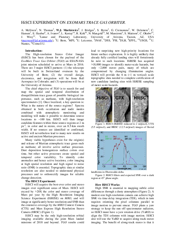
Camera (HRSC) (Figure 1).
HiSCI may be the only high-resolution orbital
imaging available during the joint Mars landed
missions of 2018 and beyond. TGO results could
lead to surprising new high-priority locations for
future surface exploration. It is highly unlikely that
already fully certified landing sites will fortuitously
lie next to such locations. HiRISE has acquired
>18,000 images to identify meter-scale hazards, but
only ~2,000 stereo pairs, many of which are
compromised by changing illumination angles.
HiSCI will provide the 6 m (~1 m vertical) scale
topographic data needed to complete certification of
new candidate landing sites with HiRISE sampling
of meter-scale hazards.
Figure 1. HiSCI (HiRISE reduced to 2 m/pixel), CTX
(5.5 m/pixel), and HRSC (12.5 m/pixel) images of fluvial
landforms in Eberswalde delta.
Figure 2. HiSCI filters and expected SNR over a dark
region at 45° phase angle.
How HiSCI Works:
High SNR is essential to mapping subtle color
differences through a dusty atmosphere (Figure 2). A
modest-size high-resolution camera can achieve high
SNR via time delay integration (TDI), which in turn
requires orienting the pixel columns parallel to
image motion to prevent smear. TGO plans a yaw
strategy to keep the sun off spectrometer radiators,
so HiSCI must have a yaw rotation drive (YaRD) to
align the TDI columns with image motion. HiSCI
also will use the YaRD to acquire along track stereo
imaging. The benefit of along-track stereo is that it
�ensures identical illumination angles for optimal
stereo correlations. The telescope will point 10°
away from nadir in the direction of TDI motion. A
stereo pair is acquired by first rotating the telescope
to point ahead 10° to image, then rotating it 180° to
point 10° behind for the second stereo view. The
build-to-print CCDs feature bidirectional TDI,
essential to HiSCI stereo. The 10° look angle
increases the pixel scale and atmospheric path length
by only 1.5%, yet provides a slightly larger than 20°
stereo convergence angle (accounting for planetary
curvature). The proper yaw orientation for TDI is
not precisely parallel to the groundtrack because
Mars rotates, and this offset also ensures excellent
overlap between the 2 stereo images (maximum
mismatch is 3% of the swath width near the
equator).
Figure 3 Top: CRISM map at ~18m/px of pyroxene
(green) and phyllosilicate (red). Bottom: Corresponding
HiRISE image re-sampled to HiSCI resolution revealing
folded pyroxene-rich and phyllosilicate-bearing beds, and
phyllosilicate-bearing blocks at bottom right. Scene is ~0.6
km across.
Synergy with CRISM:
HiSCI will provide the best color imaging ever
acquired from Mars orbit. HiRISE has revealed
spectacular small-scale color diversity, but suffers
from a very narrow color swath width. MRO’s
Compact Reconnaissance Imaging Spectrometer for
Mars (CRISM) provides high-SNR data in 545
wavelengths, but at no better than 18 m/pixel scale.
HiSCI will have excellent stray light rejection and
essentially identical photometric angles and path
lengths for each color band. Co-analysis of HiSCI
and CRISM data will be an important part of the
HiSCI investigation (Figure 3). The 2 m/pixel color
imaging improves mapping and interpretation of
mineral units identified by CRISM (Figure 3), and
Digital Terrain Models (DTMs) will enable
stratigraphic measurements.
Science Objectives:
HiSCI has 3 main objectives: (1) to better
understand active or potentially active processes
(mostly on the surface), (2) to map regions known to
release trace gases, and (3) to complete the
certification of new candidate landing sites. For
active processes we will focus on better
understanding of:
Seasonal processes (frost, gullies, aeolian
changes)
Shallow subsurface ice and related processes
Impact processes
Tectonics, mass wasting and hydrothermal
processes
Volcanic processes
Fluvial processes
Mineralogy and stratigraphy
Clouds
Note that TGO will have an inclined orbit (74°±10°)
so HiSCI cannot image polar deposits, but will
observe at all times of day to better understand
seasonal processes.
Expected Data Volume and Imaging Modes:
The minimum HiSCI data rate will be 2.9 Gb/day
(2 Tb over a Mars year), but we expect this to
increase now that TGO plans to use Ka-band
downlink. The degree of binning, image length, and
compression are commanded for each HiSCI image
so there is substantial flexibility to match the
allocated downlink rate. We will use 2x2 or 4x4
pixel binning when the SNR of surface features is
otherwise too low, such as when imaging near the
terminator or when the atmosphere is especially
dusty. HiSCI will image in color but not stereo over
many regions.
Image Products:
We will produce a set of data products similar to
those from HiRISE, including hundreds of DTMs
produced at US and European centers. HiSCI will
continue the new standard set by HiRISE for rapid
release of high-level data products to NASA’s
Planetary Data System (PDS), and to ESA’s
Planetary Science Archive (PSA). We will release
image products as soon as is practical, typically 1
month after acquisition rather than the required 6
months. There will be a website similar to
http://hirise.lpl.arizona.edu and a mirror website at
the University of Bern. We also plan an extensive
public outreach program including color flyover
movies from HiSCI stereo.
References:
[1] JIDT (2009). Final Report from the 2016
Mars Orbiter Bus Joint Instrument Definition Team,
November 2009.
�
 Candice Hansen