The International Journal of Nautical Archaeology (2002) 31.2: 228–236
doi:10.1006/ijna.2002.1045
Shipwreck in a swamp: the Burroughs site at Edenton,
N. Carolina, USA
Bradley A. Rodgers & A. Corbin
Program in Maritime Studies, East Carolina University, Greenville, North Carolina, USA
This preliminary site analysis of a suspected 18th-century shipwreck located in Edenton, North Carolina, USA, helps call to
question the roll of abandonment in the examination of ships as artefacts. Abandonments often provide an easily accessed and
inexpensive means of fleshing out knowledge of ship construction in the past. Abandonments are typically located near
historically well-used commercial ports and harbours and may now be hidden by shallow water, marshland or land fill. These
areas, in many instances, are inaccessible to normal remote sensing survey techniques.
� 2002 The Nautical Archaeology Society
Key words: derelicts, abandonments, coaster, 18th century.
Introduction
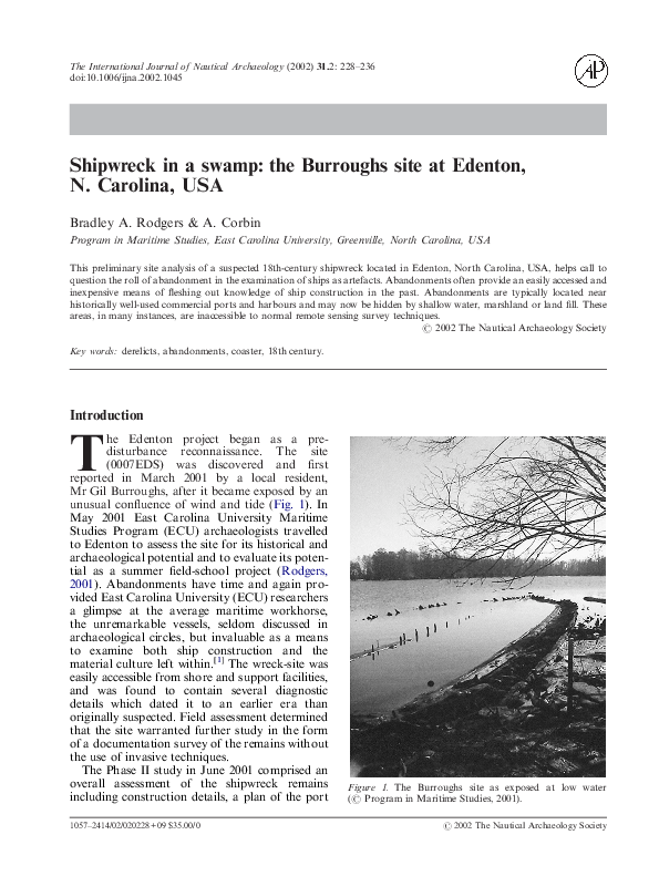
he Edenton project began as a predisturbance reconnaissance. The site
(0007EDS) was discovered and first
reported in March 2001 by a local resident,
Mr Gil Burroughs, after it became exposed by an
unusual confluence of wind and tide (Fig. 1). In
May 2001 East Carolina University Maritime
Studies Program (ECU) archaeologists travelled
to Edenton to assess the site for its historical and
archaeological potential and to evaluate its potential as a summer field-school project (Rodgers,
2001). Abandonments have time and again provided East Carolina University (ECU) researchers
a glimpse at the average maritime workhorse,
the unremarkable vessels, seldom discussed in
archaeological circles, but invaluable as a means
to examine both ship construction and the
material culture left within.[1] The wreck-site was
easily accessible from shore and support facilities,
and was found to contain several diagnostic
details which dated it to an earlier era than
originally suspected. Field assessment determined
that the site warranted further study in the form
of a documentation survey of the remains without
the use of invasive techniques.
The Phase II study in June 2001 comprised an
overall assessment of the shipwreck remains
including construction details, a plan of the port
T
1057–2414/02/020228+09 $35.00/0
Figure 1. The Burroughs site as exposed at low water
(� Program in Maritime Studies, 2001).
� 2002 The Nautical Archaeology Society
�B. A. RODGERS & A. CORBIN: SHIPWRECK IN A SWAMP
Figure 2. Map of North Carolina showing the location
of Edenton (John Hopkins University Applied Physics
Laboratory, 1995, modified by the authors).
side ceiling, frame ends, and keelson, a map of the
wreck’s orientation to the immediate shoreline,
and an assessment of diagnostic artefacts located
after sweeping debris from the port side. The site
is commonly referred to as the ‘Burroughs Site’.
Historical background
The town of Edenton, North Carolina, was
founded in 1712 and served as the colonial capitol
until 1746, when the seat of government was
moved to New Bern. Edenton is a protected port,
situated well inland on the Albermarle Sound
(Figs 2 & 3). During the second quarter of the
18th century it became a busy and prosperous
seaport. First established between the mouth of
the Pembroke and Queen Anna creeks, Edenton
had a sufficiently large natural harbour to
accommodate a large number of ships. More than
60 vessels arrived during the last six months of
1729. Trade to Edenton came from the
Northern colonies, the West Indies, and England.
Commodities traded included tobacco, naval
stores, lumber staves, headings, shingles and
planks, foodstuffs including corn, herring, and
pork, and cotton, linen, silk, shoes, hats, china,
rum, salt, coffee, sugar, and molasses (Angley &
Cashion, 1980: 4–7).
According to the Sauthier map of 1769, the
area around the Burroughs site lay beyond a
swampy point near the mouth of Pembroke
Creek and, apart from most commercial traffic,
representing an ideal abandonment area
(Sauthier, 1769). As is often the case when working vessels near the end of their useful lives,
they are disposed of through abandonment. The
abandonment areas are usually convenient to a
commercial centre but not close enough to create
an eyesore or hinder local navigation (Babits &
Figure 3. Map of Edenton Harbor on Albermarle Sound, North Carolina (� Program in Maritime Studies, 2002).
229
�NAUTICAL ARCHAEOLOGY, 31.2
Corbin, 1997). Unsurprisingly, Edenton was no
exception.
Edenton’s prosperity waxed and wained with
economic trends throughout the 18th century but
generally remained sound. Even the American
Revolution proved a boon to the port. Its well
protected, inland position, combined with the fact
that no large warships could pass over the outer
banks bar helped to ensure that Edenton was safe
from attack and virtually impossible to blockade.
In addition, the British blockade of larger east
coast ports literally drove commerce to Edenton
(Angley & Cashion, 1987: 15).
However, by the 19th century both man-made
and natural factors combined to slow commerce
to a trickle. After the first quarter of the century
the catalyst for decline became the opening and
widening of the Dismal Swamp Canal in 1805,
1819, and 1825, respectively. The canal moved the
state’s economic focus eastward to Elizabeth City.
It also proved an efficient link between the
northern and southern colonies by passing commerce inland and bypassing the ever dangerous
coastal waters of North Carolina. North Carolina
is still known as the graveyard of the Atlantic
because of its hurricanes, shifting shoals, and
conflicting ocean currents. In 1828 Currituck Inlet
silted over, forever closing the old trade route to
Edenton. As a result, Edenton lost much of its
commercial revenues, surviving instead on fishing
and agriculture. Its main crops were peanuts and
cotton, and continue to be so. Today, however, it
seems that Edenton’s curse has also become its
blessing. Many of its 18th-century buildings
have been preserved and the town’s ambience has
attracted a thriving tourist industry.
Project area
The wreck is located at the mouth of Pembroke
Creek, approximately 0·96 km (0·6 miles) west of
downtown Edenton. The vessel has a north-south
orientation with the bow facing the shore and the
stern facing the creek (Fig. 4). The bottom consists of soft silty mud and a large quantity of
lumber offcuts that originated from a nearby
19th- and early 20th-century sawmill. Water
depth on site varied from 0·61 m to 1·22 m (2 to
4 ft) with minimal tidal fluctuations. The creek
bottom is stable and relatively flat with a gradual
increase in depth toward the channel. This is a
typical inland river-mouth site with black tannic
water and visibility ranging from 0 to 0·61 m (0 to
230
Figure 4. Location of the Burroughs wreck-site at the
mouth of Pembroke Creek, North Carolina (� Program in
Maritime Studies, 2002).
2 ft). The area is infrequently disturbed by winddriven
currents and boat wash. Vegetation consists of a
concentration of water lilies, cypress trees, and
river algae. Marine and marsh life encountered
included freshwater mussels, leeches, snakes,
crabs, fish, and birds.
Phase II testing
After establishing the site parameters, a datum,
and laying a baseline, the project crew commenced with clearing a 3·05 m (10 ft) wide
transect across the vessel amidships from the port
side turn of the bilge to the starboard side turn of
the bilge, crossing the keelson. Most of the interior debris was found to be detritus such as
aluminium cans, which had clearly drifted in and
out of the site with changing water conditions.
Accumulated mud and organic material in
the hold area never exceeded 10 cm (3·94 ins).
Though all dredged material was sifted for
artefacts, little historically significant material
remained in the test swath and those that were
located were primarily intrusive items associated
�B. A. RODGERS & A. CORBIN: SHIPWRECK IN A SWAMP
Figure 5. Cross section of the Burroughs site, taken from the stem looking forward (� Program in
Maritime Studies, 2002).
with local 19th-century logging operations. It
seemed clear that the ship had been nearly
stripped of artefacts before it was burned and
abandoned. Despite this, the vessel is remarkably
preserved from the keelson to the turn of the
bilge. Since there was no stratigraphy it was
decided to sweep clean the entire port side of the
wreck, but sift the overburden for diagnostic
material.
Description of findings
The lower portion of the white oak vessel was
largely intact from the keel/keelson to the turn
of the bilge. Most notable of the hull details
included: the sacrificial pine planking attached
to the outer side of the hull, the lack of a
centre-board, and scarf chocks between the floors
and futtocks. In addition, the floors were notched
over the keel and the keelson was notched to
accept the floors. The floors were connected to the
futtocks via five-sided scarf chocks (Fig. 5).
The keelson comprised the main keelson plus a
decayed half rider or hog that sat on top of it
to provide additional longitudinal strength, and
to accept the mast-steps. Only one mast-step
survived; this was 3·05 m (10 ft) from the sternpost. Iron drift bolts secured the rider, the keelson, and the keel through the floors. The keelson
was scarfed with a recognizable ‘hook and wedge
scarf’ with the keys still in place.
White oak ceiling planking 6·35 cm (2·5 ins)
thick survived from the keelson to the turn of the
bilge and there was clear evidence that periodic
repairs were made to it. Outer hull planking
51 mm (2 ins) thick was recorded protruding from
the mud at the turn of the bilge; no doubt it is
intact below this as far as the keel.
The sternpost and inner sternpost were intact
and the rabbet to accept the outer hull planking
was still visible above the side strakes. The lower
gudgeon strap is secured in this area and the lower
part of the rudder was attached to the gudgeon by
means of a pintle. The lower stem, cutwater, and
gripe were also intact along with the rabbet to
accept the hull planking. The lower cant frames
were also intact in the bow although obscured at
their base by a cypress root that had extended
itself through the bow (Fig. 6).
The wreck clearly demonstrated evidence of fire
with substantial amounts of charred wood in the
dredged spoil and charring along the frame ends.
An overall lack of artefacts and ballast suggests
that the ship was brought to shore to be repaired
or was abandoned after being found unworthy of
repair. At that time any remaining cargo and
personal items could have been removed and
the vessel burnt in order to salvage the fastenings.
The location of the wreck in a shallow easily
accessible environment may also have contributed
to stripping of artefacts by townsfolk over the
years.
The first futtocks begin only 152 mm (6 ins)
from the keelson, a possible indicator of early
18th-century construction. It had minimal deadrise and a shallow draft of only 1·83 to 2·75 m
(6 to 9 ft), suggesting a coasting design. The depth
231
�NAUTICAL ARCHAEOLOGY, 31.2
232
Figure 6. Overall site plan of the wreck found at the Burroughs site (� Program in Maritime Studies, 2002).
�B. A. RODGERS & A. CORBIN: SHIPWRECK IN A SWAMP
Figure 7. A variety of iron fasteners found at the wreck-site
(� Program in Maritime Studies, 2002).
today suggests that considerable silting has taken
place in the area since the 18th century if the
vessel was burnt in situ.
Artefacts
The largest group of artefacts discovered included
intrusive chains, log offcuts and log staples, all to
be associated with the local lumbering operations.
These artefacts were scattered over the wreck and
seemingly intrusive. They occur over a wide area
and are clearly associated with local activities
unconnected with the wreck.
A number of iron and wood fasteners were
associated with the vessel including treenails and
wrought-iron nails and spikes. The iron fasteners
were handmade and include primarily roseheaded nails with chisel points. The iron fasteners
are in varying states of preservation and are of
varying dimensions; no two are alike (Fig. 7).
Based on standard dating and evaluation
criteria for hand wrought nails it appears that the
fasteners from the site date from the mid 18th
century and are certainly no later than 1805.
Samples from the wreck compare closely with
samples extracted from a Louisiana building of
the same period (Meverden, 2001: 12–13). All the
treenails found on site were eight-sided and in
varying states of decay. Many showed signs of
burning.
An interesting corollary to the fasteners
involves a concentration of what can only be
described as scrap iron hask found in the port side
bow area of the wreck. This ‘hask’ consists of
small sections of scrap nail plate and cut nails
Figure 8. A two-sheave, or double block located in the
wreck-site (� Program in Maritime Studies, 2002).
seemingly melted and welded together in a slurry
of raw iron ore. Evidence of the burlap bag in
which this material was stored exists in the form
of burlap impressions on some of the scrap iron.
Since much of the material in the hull is intrusive
it cannot be stated with certainty that the cut
nail evidence relates to the wreck. However, if it
did belong, it would push the date of the vessel’s
destruction to the later 18th or early 19th century.
Farriers have suggested that such scrap and
hask collections may signal emergency collection, a contingency used in time of war (Smyth,
pers. comm., 2001).
Material associated with the ship’s rigging also
make up the artefact collection. Most notable
were the large amounts of charred rope and a
complete, two-sheave block (double block), made
entirely of wood, with a rope strop (missing),
lignum vitae sheaves, and oak block cheeks
(Fig. 8). Additional pieces of disarticulated blocks
and severely charred sheave remains were also
located. The intact block measured 127�89�
89 mm (5�3·5�3·5 ins). One side of the block
was badly damaged by fire but the other face was
diagnostically sound. Further evaluation of the
block suggests that the piece is made entirely of
wood with the internal sheaves being made of
lignum vitae (Guiacum sanctum), commonly
known as ironwood due to its hardness. The block
also shows signs of being machine-made (a post1760 development). Current research suggests a
possible date-bracket for this type of block as the
late 18th to early 19th century (Goodall, 2001:
4–8).
233
�NAUTICAL ARCHAEOLOGY, 31.2
Figure 9. Grape shot and Spanish or ‘peak shot’ associated
with the wreck-site (� Program in Maritime Studies, 2002).
Three pieces of ceramic were found, all creamcoloured earthenware. More specifically, one was
a piece of pearlwear with a moulded rim. It was
hand-painted with an indistinguishable ‘feather’
pattern using the underglaze technique. The
second piece was pearlware with a clear glaze. The
third piece was creamware, also with a clear glaze.
Initial analysis dates the fragments between 1770
and 1830 (Derby, 2001: 10).
The most interesting, and ultimately the most
diagnostic, artefacts were the items of weaponry
that were found. Several pieces of canister or
grapeshot and two pieces of ‘Spanish shot’, also
known as star-shot or spikeshot, were found. The
star-shot is an elongated object tapering to point
at both ends (Fig. 9). It has a four-sided shaft
which resembles two overly elongated pyramids
joined at their bases and may have been produced
simply by welding two spikes together at their
heads. A ring, approximately 39 mm (1·55 ins),
encircles the shaft at the midpoint and may indicate the approximate calibre of the gun intended
to fire it. The grain lines of the central ring run
counter to the shaft indicating that the ring was
wrapped around the shaft in a forge. The overall
length of the star-shot after conservation is
250 mm (9·8 ins) (Lewis, 2001: 3).
Little published documentation regarding starshot ordnance like that found at the Edenton site
exists. The apparent rarity of such items in the
historical record in the United States prompts
speculation, both concerning the ordnance and its
association with the shipwreck. Neither of the
pieces found had any visible marks indicating date
or manufacturer which would have aided identification. The closest example of star-shot recovered
archaeologically comes from the excavation of a
234
Figure 10. A wooden carpenter’s bevel with the owner’s
initials ‘ID’ carved on the body (� Program in Maritime
Studies, 2002).
16th-century English vessel, wrecked on Alderney,
one of the Channel Islands. At the Alderney site,
nine objects were reported which were described
as ‘about 3 in. in diameter with 5 in. spikes on
either side’ (Davenport & Burns, 1995: 34, fig. 5).
These examples are similar in design to the
Edenton star-shot, although the latter was not
cast. Additionally, the Alderney star-shot
was described as anti-ship and anti-personnel
ordnance (Bound, 1998: 71).
The unique shape of the star-shot allowed
incendiary material to be wrapped around the
protruding ends and then fired at the hulls of
ships or into their rigging. The points would
penetrate the hull while allowing the fire and fuel
to catch and burn the vessel. The 16th-century
starshot and the Edenton starshot have several
similarities worth noting. Both consist of a
double-ended iron rod, pointed at both ends. The
Alderney ordnance is approximately 100 mm
(4 ins) shorter (Lewis, 2001: 3–5). Both samples
contain a centrepiece attached after the shaft was
forged. In the case of the 16th-century example
the central piece is a two-part sphere approximately 79 mm (381 in) in diameter, rather than a
wrought-iron ring as found on the Edenton specimen. Unlike the Edenton piece the Alderney
star-shot is marked with an ‘R’ (Lewis, 2001: 5). It
seems likely that the Edenton spike-shot represents a ‘homemade’ piece of ordnance and is
unlikely to represent Royal Naval or US Naval
ordnance.
An additional significant artefact is a wooden
carpenter’s or shipwright’s bevel used to mark
angles on wood (Fig. 10). It has an overall length
of 241 mm (9·5 in), is 25 mm (1 in) wide by 19 mm
(0·75 in) deep and is personalized with the
inscribed initials ‘I D’. Although it is unclear if
this artefact was lost with the ship or is intrusive,
�B. A. RODGERS & A. CORBIN: SHIPWRECK IN A SWAMP
it is the type of tool likely to have been carried on
board.[2]
Finally, a number of seeds were recovered
during cleaning the ceiling. Prominent among
these samples are peanuts and cotton seeds
indicative of the ship’s environment or cargo.
Conclusions
The wreck remains at the Burroughs site clearly
represent a seagoing wooden vessel designed for
coastal trade with a waterline length of about
24·38 m (80 ft) and an overall length of about
29·26 m (96 ft). It had a 7–7·6 m (23–25 ft) beam
and, therefore, had a 3·5–3·8 m (11·5–12·5 ft)
mean depth of hold. These figures in Old Measure
Tonnage (1773 rules) indicate a capacity of
between 231 and 269 tons. Construction details
are consistent with early to mid 18th-century techniques as are the fasteners, some of the ceramics,
and the block. The relative dearth of fasteners and
other artefacts suggests the vessel was intentionally abandoned, scavenged, and burnt for its iron
in the late 18th or early 19th century. This is
consistent with historical and archaeological
accounts of other abandoned vessels of this date.
Comparative artefact analysis in conjunction with
known structural features narrow the approximate date of build to the first or second quarter of
the 18th century and destruction in the later part
of the 18th or early 19th century. The few artefacts
recovered associated with the wreck corroborate
the vessel’s long life. The ordnance and hask
suggest a wartime influence, perhaps that of the
American Revolution.
Further investigation is certainly warranted in
this case as only a handful of 18th-century vessels
have been located and investigated in North
Carolina waters. Additional work is planned and
the site will be the focus of Kate Goodall’s ECU
masters thesis.
Acknowledgements
The authors wish to express their thanks and
appreciation to Mr Gil Burroughs who discovered
this site and reported it to ECU for possible
investigation. This work and field school would
not have been possible without the assistance
and support provided by the people and city of
Edenton, North Carolina, particularly Mayor
Roland H. Vaughn and Town Manager,
Anne-Marie Knighton. Much appreciation also
goes to Mr Jeff Knox and his wife Rae for their
hospitality and logistical assistance. Fieldwork was
made possible with the help of our crew: Assistant
P. I., Frank Cantelas, crew chiefs Matt Lawrence
and Deborah Marx, and crew members Kate
Goodall, Marc Porter, Carrie Bell, Steve Williams,
John Hart Asher, Jason Paling, Mike Overfield,
Alena Derby, and Keith Meverden. Thanks and
appreciation to Kate Goodall for mapwork
and historical background and to Christopher F.
Valvano for photographing the artefacts.
Notes
[1] (See Babits & Corbin, 1995; Babits et al, 1995; Babits & Corbin, 1997; Kjorness & Babits, 2000; Merriman, 1997; Rodgers,
1995; 1999; Rodgers & Corbin, 2001; Watts & Hall, 1986).
[2] Ross, L. A., 1979, Underwater Archaeologists Vade Mecum to the Companies, Duties, Tools and Related Supplies of the
18th-Century British and French Naval Vessels. Unpublished MS in the possession of the author.
References
Babits, L. E. & Corbin, A., 1997, Locating small boats in the archaeological record: a model from the North Carolina Sounds.
Museum Small Craft Association, Transactions, 3: 34–45.
Bound, M., 1998, A wreck off Alderney from the late Elizabethan Period: an analysis of the artefacts. In M. Bound (Ed.),
Excavating Ships of War, 2: 6–83. Oswestry.
Daventry, T. G. & Burns, R., 1995, A sixteenth century wreck off the island of Alderney. In M. Bound (Ed.), The Archaeology
of Ships of War, 1: 34–40. Oswestry.
Kjorness, A. C. & Babits, L. E., 2000, A derelict small boat survey Pamlico Drainage, North Carolina, USA. In J. Litwin (Ed.),
Down the River to the Sea, 8th International Symposium on Boat and Ship Archaeology, Gdansk, Poland, 1997, 193–196.
Merriman, A. M., 1997, The Cypres Landing Shipwreck of Chocowinity Bay: A North Carolina Sail Flat. Research Report No.
9, East Carolina University, Greenville.
Rodgers, B. A., 1995, The 1995 Predisturbance Wreck Site Investigation at Clafin Point, Little Sturgeon Bay, Wisconsin.
Research Report No. 10, East Carolina University, Greenville.
235
�NAUTICAL ARCHAEOLOGY, 31.2
Unpublished reports on file in East Carolina University, Greenville and elsewhere
Angley, W. & Cashion, J. C. (Eds), 1980, Historical Research Reports, Series I—State of North Carolina, H629 series 1, #19
microfilm, North Carolina Collection, East Carolina University, Greenville.
Babits, L. E. & Corbin [Kjorness] A., 1995, A Final Report on an Archaeological Survey of the Western Shore of the Pungo River
from Wades Point to Woodstock Point. Report on file North Carolina Department of Cultural Resources, Raleigh, NC.
Babits, L. E., Morris, J. & Corbin [Kjorness] A., 1995, A Survey of the North Shore Pamlico River: Bath Creek to Wade’s Point.
Report on file North Carolina Department of Cultural Resources, Raleigh, NC.
Derby, A., 2001, Conservation of Ceramic and Brick from the Burrough’s Site, Edenton, NC. Report for the East Carolina
University Conservation Lab, Grenville, NC.
Goodall, K., 2001, Conservation of a Wooden Block from Edenton Site. Report for the East Carolina University Conservation
Lab, Grenville, NC.
Lewis, R., 2001, Conservation of a Starshot. Report for the East Carolina University Conservation Lab, Grenville, NC.
Meverden, K., 2001, Conservation of Iron Fasteners from the Burrough’s Site (0007EDS), Edenton, North Carolina. Report for
the East Carolina University Conservation Lab, Grenville, NC.
Rodgers, B. A., 1999, The 1999 Bullhead Point Stone Barge Investigation. Interim Report. Technical Publication No. 5, State
Historical Society of Wisconsin, Madison.
Rodgers, B. A., 2001, Burroughs’ Site, Edenton, North Carolina (0007EDS): Preliminary Site Analysis Conducted by East
Carolina University’s Program in Maritime Studies, June 2001. Report for the North Carolina Underwater Archaeology Unit.
Rodgers, B. A. & Corbin, A., 2001, Birmingham’s Site Analysis, Scow Schooner Dan Hayes, Sturgeon Bay, Wisconsin. Report
for the State Historical Society of Wisconsin, Madison.
Sauthier, C. J., 1769, Plan of the Town and Port of Edenton in Chowan County North Carolina, 1769. Historic Map files, North
Carolina Division of Archives and History, Raleigh.
Watts, G. P., Jr. & Hall, W. K., 1986, An Investigation of Blossom’s Ferry on the Northeast Cape Fear River. Research Report
No. 1, East Carolina University, Greenville.
236
�
 Annalies Corbin