Eos,Vol. 85, No. 43, 26 October 2004
VOLUME 85
NUMBER 43
26 OCTOBER 2004
PAGES 433–448
EOS,TRANSACTIONS, AMERICAN GEOPHYSICAL UNION
Examining Tectonic-Climatic
Interactions in Alaska and
the Northeastern Pacific
PAGES 433, 438–439
Southeastern Alaska, encompassing the
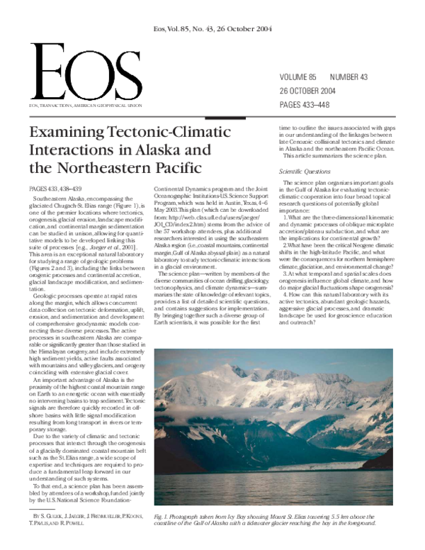
glaciated Chugach-St. Elias range (Figure 1), is
one of the premier locations where tectonics,
orogenesis, glacial erosion, landscape modification, and continental margin sedimentation
can be studied in unison, allowing for quantitative models to be developed linking this
suite of processes [e.g., Jaeger et al., 2001].
This area is an exceptional natural laboratory
for studying a range of geologic problems
(Figures 2 and 3), including the links between
orogenic processes and continental accretion,
glacial landscape modification, and sedimentation.
Geologic processes operate at rapid rates
along the margin, which allows concurrent
data collection on tectonic deformation, uplift,
erosion, and sedimentation and development
of comprehensive geodynamic models connecting these diverse processes.The active
processes in southeastern Alaska are comparable or significantly greater than those studied in
the Himalayan orogeny, and include extremely
high sediment yields, active faults associated
with mountains and valley glaciers,and orogeny
coinciding with extensive glacial cover.
An important advantage of Alaska is the
proximity of the highest coastal mountain range
on Earth to an energetic ocean with essentially
no intervening basins to trap sediment.Tectonic
signals are therefore quickly recorded in offshore basins with little signal modification
resulting from long transport in rivers or temporary storage.
Due to the variety of climatic and tectonic
processes that interact through the orogenesis
of a glacially dominated coastal mountain belt
such as the St. Elias range, a wide scope of
expertise and techniques are required to produce a fundamental leap forward in our
understanding of such systems.
To that end, a science plan has been assembled by attendees of a workshop, funded jointly
by the U.S. National Science FoundationBY S. GULICK, J. JAEGER, J. FREYMUELLER, P. KOONS,
T. PAVLIS, AND R. POWELL
Continental Dynamics program and the Joint
Oceanographic Institutions-U.S.Science Support
Program, which was held in Austin,Texas, 4–6
May 2003.This plan (which can be downloaded
from: http://web. clas.ufl.edu/users/jaeger/
JOI_CD/index2.htm) stems from the advice of
the 57 workshop attendees, plus additional
researchers interested in using the southeastern
Alaska region (i.e.,coastal mountains,continental
margin,Gulf of Alaska abyssal plain) as a natural
laboratory to study tectonic-climatic interactions
in a glacial environment.
The science plan—written by members of the
diverse communities of ocean drilling,glaciology,
tectonophysics, and climate dynamics—summarizes the state of knowledge of relevant topics,
provides a list of detailed scientific questions,
and contains suggestions for implementation.
By bringing together such a diverse group of
Earth scientists, it was possible for the first
time to outline the issues associated with gaps
in our understanding of the linkages between
late Cenozoic collisional tectonics and climate
in Alaska and the northeastern Pacific Ocean.
This article summarizes the science plan.
Scientific Questions
The science plan organizes important goals
in the Gulf of Alaska for evaluating tectonicclimatic cooperation into four broad topical
research questions of potentially global
importance:
1.What are the three-dimensional kinematic
and dynamic processes of oblique microplate
accretion/plateau subduction, and what are
the implications for continental growth?
2.What have been the critical Neogene climatic
shifts in the high-latitude Pacific, and what
were the consequences for northern hemisphere
climate, glaciation, and environmental change?
3.At what temporal and spatial scales does
orogenesis influence global climate, and how
do major glacial fluctuations shape orogenesis?
4. How can this natural laboratory with its
active tectonics, abundant geologic hazards,
aggressive glacial processes, and dramatic
landscape be used for geoscience education
and outreach?
Fig. 1. Photograph taken from Icy Bay showing Mount St. Elias towering 5.5 km above the
coastline of the Gulf of Alaska with a tidewater glacier reaching the bay in the foreground.
�Eos,Vol. 85, No. 43, 26 October 2004
Coring Project, Paleoenvironmental Arctic Sciences (PARCS), Past Global Changes (PAGESIGBP), and Study of Environmental Arctic
Change (SEARCH).
Implementation Phases
Because of the far-reaching scope of the
issues raised in this science plan, it is not possible to create a comprehensive implementation plan.Instead,a general list of recommended
tasks have been grouped into three implementation phases that reflect logistical concerns
and the need to address the most glaring gaps
in knowledge and data.
Phase 1
Fig. 2. Gulf of Alaska region: geography and location of previous DSDP and ODP drilling locations
(see inset). Composite of MODIS images (taken at different times) for southern Alaska courtesy
of MODIS Rapid Response Project at NASA/GSFC. Shaded bathymetry is from ETOPO2 global
elevation data. Inset map shows overall location.
Why Southeastern Alaska?
Several key points are raised as to why
southeastern Alaska provides such an excellent setting for insight into these four global
questions.Tectonically, it can serve as a modern
analog for processes that have constructed
much of the continental crust through terrane
accretion.The margin encompasses a subduction to strike-slip transition that is observable
both onshore and offshore, allowing imaging
of crust-mantle interaction at such transitions.
This plate boundary has generated the secondlargest historical earthquake (1964), the largest
historical tsunami (1958), the largest area of
coseismic uplift (1964), and the greatest documented coseismic uplift (14.2 m in 1899). Present tectonic convergence rates are 2–3 times
as high as in the Himalaya and are comparable
to the total convergence between India and
Eurasia.
Climatically, the area includes the oldest and
thickest northern hemisphere Cenozoic glacial
record, and studies in this region can illuminate
the currently poorly constrained history of the
Cordilleran ice sheet, potentially including its
initiation, and its significance for global climate
dynamics.The expanded Neogene marine and
glacial sedimentary record within the North
Pacific can enhance other high-latitude climate
records.The Gulf of Alaska is a prime site for
assessing the history of Holocene (or longer)
decadal-scale (e.g., Pacific Interdecadal Oscillation or PDO) climate change, both geographically and due to high sediment volumes
producing very high resolution paleoclimate
records. Finally, there is an opportunity to constrain the Late Quaternary marginal marine
environment to assess the feasibility of pre-historical human coastal migration routes.
The Chugach-St. Elias range is a mini-orogeny
where tectonic and climatic processes and
their interactions may be studied at a tractable
scale.The landscape is sculpted primarily by
glacial processes that produce the highest
global glacial denudation rates (over 101 mm
a-1) and in turn provide record high sediment
accumulation rates allowing for very high resolution proxy sedimentary records.This margin is the type location for temperate glacimarine
systems and their models, and a unique ~5km-thick sedimentary record of deposition
recording at least 6 Ma of tectonic and climatic
interaction is present. Because of the relatively
confined and closed source-to-sink depositional
system, there may be little lag between sediment production and marine accumulation.
Tectonically, observable deformation patterns
in oblique convergent settings may reflect climatic influences.The tectonic setting, Neogene
stratigraphy and sedimentary processes, glacial
mass-balance, and structural and metamorphic
history are reasonably well characterized,which
allows for development of integrated experiments in tectonic and climatic interaction.
Purpose and Interactions
The science plan is intended to assist in proposal preparation and evaluation for future
Gulf of Alaska studies, and practitioners of the
numerous techniques summarized the key
measurements necessary for addressing the
scientific questions. Opportunities for education and outreach including “teacher in the
field”programs,interactions with National Parks,
and Native American nations were discussed.
This research initiative also has strong links to
several programs beyond IODP and NSF-funded core research, including Earthscope, ICESat, Marine Aspects of Earth System History
(MESH),U.S.GLobal Ocean Ecosystems Dynamics
(U.S. GLOBEC), Community Surface Dynamics
Modeling System (CSDMS), River-Dominated
Ocean Margins (RiOMar), the Mt. Logan Ice
Developing and maintaining a Gulf of Alaska
research Web site and an Alaska GIS database
for integration of emerging interdisciplinary
data sets is a high priority. Because of the outreach potential, all future field and laboratory
projects should have a strong outreach component from the beginning of the program
with Web sites identified and accessible to
K-12 education.
Particular Phase 1 experiments should include
the acquisition of both high-resolution and
regional marine seismic reflection surveys to
adequately understand the regional sedimentary budget, examine the offshore tectonic
deformation, and plan for future IODP drilling.
A comprehensive suite of very high resolution paleoclimatic, paleoceanographic, and
paleoecological studies on cores from the
margin will establish proper chronometers
and a series of climate proxies leading to an
understanding of the Quaternary climatic history that can be later extended into the Neogene through ocean drilling and terrestrial
outcrop sampling.
A GPS array should be installed rapidly to
ensure a sufficiently long period of observation to exceed 1 mm a-1 horizontal and 2 mm
a-1 vertical precision. Existing monitoring surveys of glacial and fluvial mass fluxes should
be maintained and expanded to ensure continuity of records in an aim to capture transients
in mass flux.
Expansion of modern automated meteorological arrays is important for constructing
sufficiently long climate time series that permit integration of records from high-altitude
ice core sites to sea level marine records.
Establishment of a passive seismic monitoring
array will be necessary for imaging crustal
and upper mantle velocity structure and evaluating seismic hazards.A modeling program
should be initiated to aid in sampling strategies,
to investigate cooperation among systems,
and to develop numerical strategies for handling the nonlinear interactions in the climatic-tectonic system.
Phase 2
The collection of the initial data sets in Phase
1 will allow for the refinement of experiments
that can investigate stratigraphic, structural,
and petrologic processes and relationships to
�Eos,Vol. 85, No. 43, 26 October 2004
proposed targeting of the southeastern Alaska
natural laboratory with a broad range of techniques to study a series of dynamic but interrelated processes that will allow significant
advancement in our understanding of continental dynamics, glacial-interglacial climate,
and their interactions.The process has already
begun,as some of these recommended studies
have been proposed and recommended for
funding by NSF.
Acknowledgments
The authors thank the attendees of the Tectonics and Climate in Alaska workshop in
Austin,Texas, and the contributors to the science plan.This workshop, which the science
plan and this article grew out of,was sponsored
by NSF Continental Dynamics and Joint Oceanographic Institutions,Inc.The efforts of Judy Jacobs
and an anonymous reviewer are appreciated.
This article is UTIG Contribution 1705.
References
Fig. 3.Tectonostratigraphic terranes and structural features of southern Alaska and adjacent Gulf
of Alaska. Modified from Plafker [1987] and Plafker et al. [1994].
examine orogenic history, mass flux, and
climate interactions through the system.
A geochronological framework should be
developed early in Phase 2 to identify trends
in local kinematics using low- and high-temperature thermochronology, cosmogenic
dating, detrital thermochronology, fluid inclusion, and geological studies.To constrain the
spatially varying tectonic geometry, an active
seismic study of crustal architecture should
be conducted onshore and offshore to collect
two-dimensional and three-dimensional
tomography.Aerogeophysical, marine geophysical, and remote sensing programs need to be
initiated to determine the gravity field, ice
thickness,and integrated topographic-bathymetric
surface to serve as baseline data for repeat
surveys that monitor temporal changes. Geometric information from seismic studies and
mass flux data should be used to condition,
test,and develop the numerical models focused
on kinematics, denudation, sediment transport,
and storage.
Phase 3
Repeat marine and aerogeophysical, and
satellite-based remotely sensed surveys to
examine landscape evolution should be
acquired. Repeat surveys of GPS arrays would
provide additional information on local velocity
fields. Offshore IODP drilling from fjords to
deep-sea fans will examine the integrated tectonic-climatic history of the margin. Drilling
builds on all previous geophysical, geological,
ecological, climatic, and modeling efforts to
enhance an integrated picture of the cooperation between climate and tectonic processes.
Conclusion
While these recommendations are wideranging and ambitious, it is through the
Jaeger, J. M. et al. (2001), Orogenic and glacial
research in pristine southern Alaska, Eos,Trans.,
AGU, 82 (19), 213, 216.
Plafker, G. (1987), Regional geology and petroleum
potential of the northern Gulf of Alaska continental
margin, in Geology and Resource Potential of the
Continental Margin of Western North America and
Adjacent Ocean Basins, Earth Sci. Ser., vol. 6, edited
by D.W. Scholl,A. Grantz and J. G.Vedder, pp. 229268, Circum-Pacific Counc. for Energy and Miner.
Resour., Houston,Tex.
Plafker, G., J. C. Moore, and G. R.Winkler (1994), Geology of the southern Alaska margin, in The Geology
of Alaska, volume G-1, edited by G. Plafker and H.
C. Berg, pp. 389–449, Geol. Soc. of Am., Boulder,
Colo.
Author Information
Sean Gulick, University of Texas,Austin; John
Jaeger, University of Florida, Gainesville; Jeff
Freymueller, University of Alaska, Fairbanks; Peter
Koons, University of Maine, Orono; Terry Pavlis,
University of New Orleans, La.; and Ross Powell,
Northern Illinois University, DeKalb
For additional information or a printed version of
the science plan, contact Sean Gulick at sean@ig.
utexas.edu, or John Jaeger at jaeger@geology.ufl.edu.
�
 Jeff Freymueller