Hindawi Publishing Corporation
Journal of Geochemistry
Volume 2014, Article ID 960139, 13 pages
http://dx.doi.org/10.1155/2014/960139
Research Article
Determination of Provenance and Tectonic Settings of Niger
Delta Clastic Facies Using Well-Y, Onshore Delta State, Nigeria
S. O. Oni, A. S. Olatunji, and O. A. Ehinola
Department of Geology, University of Ibadan, Ibadan 200284, Oyo State, Nigeria
Correspondence should be addressed to S. O. Oni; talk2nicesam@hotmail.com
Received 25 August 2014; Revised 8 November 2014; Accepted 10 November 2014; Published 28 December 2014
Academic Editor: Franco Tassi
Copyright © 2014 S. O. Oni et al. his is an open access article distributed under the Creative Commons Attribution License, which
permits unrestricted use, distribution, and reproduction in any medium, provided the original work is properly cited.
Provenance analysis serves to reconstruct the predepositional history of a sediment/sedimentary rock. his paper focuses on the
reconstruction of the provenance and tectonic settings of the Niger delta clastic facies using geochemical approach. he main types
of geochemical tests include major, trace, and rare earth element (REE) tests. Twenty-one samples of shales and sandstones units
were purposely collected from a depth between 1160 and 11,480 m, grinded, pulverized, and sieved with a <75 �m. About 5 g was
packed and sent to Acme analytical Laboratory Ltd., Vancouver, Canada. he analyses were carried out by both induced coupled
plasma-mass spectrometry (ICP-MS) and induced coupled plasma-emission spectrometry (ICP-ES). Bulk-rock geochemistry of
major oxides, trace elements, and rare earth elements was utilized for the provenance and tectonic setting determination. Based on
the discrimination diagram for major oxides, the probable provenance of the south eastern Delta clastic sediments was mainly of
the active continental margins. he bivariate plots of La versus h, La/Y versus Sc/Cr, and Ti/Zr versus La/Sc and the trivariate plots
of La-h-Sc, h-Sc-Zr/10, and h-Co-Zr/10 are all plotted on the ields of active continental margin sediments which is consistent
with the known actively opening of a failed arm of triple junction. he trace elements and REE analysis indicates that they are
virtually Fe-rich, lithic/quartz arkosic sandstones. he normalizing factors used for the REE are Wakita chondrite. heir rare earth
elements (REE) pattern displays high light REE/heavy REE (LREE/HREE) ratio, lat HREE, and a signiicant negative Eu anomaly
which correlate well with the UCC and PAAS average composition. he source area may have contained felsic igneous rocks.
1. Introduction
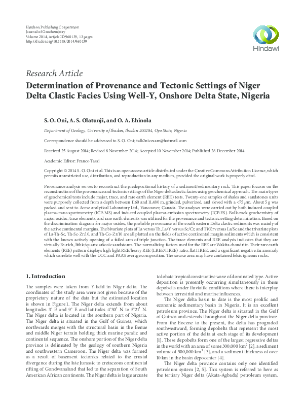
he samples were taken from Y-ield in Niger delta. he
coordinates of the study area were not given because of the
proprietary nature of the data but the estimated location
is shown in Figure 1. he Niger delta extends from about
longitudes 3∘ E and 9∘ E and latitudes 4∘ 30� N to 5∘ 21� N.
he Niger delta is located in the southern part of Nigeria.
he Niger delta is situated in the Gulf of Guinea, which
northwards merges with the structural basin in the Benue
and middle Niger terrain holding thick marine paralic and
continental sequence. he onshore portion of the Niger delta
province is delineated by the geology of southern Nigeria
and southwestern Cameroon. he Niger delta was formed
as a result of basement tectonics related to the crustal
divergence during the late Jurassic to cretaceous continental
riting of Gondwanaland that led to the separation of South
American African continents. he Niger delta is large arcuate
to lobate tropical constructive wave of dominated type. Active
deposition is presently occurring simultaneously in these
depobelts under luviatile conditions where there is interplay
between terrestrial and marine inluences.
he Niger delta basin to date is the most proliic and
economic sedimentary basin in Nigeria. It is an excellent
petroleum province. he Niger delta is situated in the Gulf
of Guinea and extends throughout the Niger delta province.
From the Eocene to the present, the delta has prograded
southwestward, forming depobelts that represent the most
active portion of the delta at each stage of its development
[1]. hese depobelts form one of the largest regressive deltas
in the world with an area of some 300,000 km2 [2], a sediment
volume of 500,000 km3 [3], and a sediment thickness of over
10 km in the basin depocenter [4].
he Niger delta province contains only one identiied
petroleum system [2, 5]. his system is referred to here as
the tertiary Niger delta (Akata-Agbada) petroleum system.
�2
Journal of Geochemistry
5.0
4.0 Passive margin
3.0
Oceanic island arc
2.0
1.0
0.0
−1.0
CIA
−2.0
−3.0
Active continental margin
−4.0
−5.0
−6.0
−4.0
−2.0
−8.0 −7.0−6.0
0.0
2.0
4.0
−8.0
Discriminant
−9.0
−10.0
Discriminant function 2
9∘
8∘
7∘
6∘
−10.0
5∘
4∘
0
(km)
50 100
∘
5E
Series 1
∘
6E
Study area
Eocene recent cycle with
approximate coast lines
Campanian-Paleocene cycle
∘
7E
∘
8E
Albian-Santonian cycle
Metamorphic basement
complex (precretaceous)
Volcanics
Figure 2: he plot of discriminant 2 against discriminant 1; the
discriminant function diagram for sandstones (ater [8]), showing
ields for sandstones from passive continental margins, oceanic
island arcs, continental island arcs, and active continental margins.
he CIA at the centre represents continental island arc.
1.0
Oceanic arc
Figure 1: Generalized and simpliied geological map of Niger delta
basin as obtained from http://www.intechopen.com.
TiO2 (%)
he maximum extent of the petroleum system coincides
with the boundaries of the province. he minimum extent
of the system is deined by the areal extent of ields and
contains known resources (cumulative production plus
proved reserves) of 34.5 billion barrels of oil (BBO), 93.8
trillion cubic feet of gas (TCFG), and 14.9 billion barrels of oil
equivalent (BBOE) [6]. Currently, most of this petroleum is
in ields that are onshore or on the continental shelf in waters
less than 200 meters deep and occurs primarily in large,
relatively simple structures. Among the provinces ranked in
the U.S. Geological Survey’s World Energy Assessment [7],
the Niger delta province is the twelth richest in petroleum
resources, with 2.2% of the world’s discovered oil and 1.4%
of the world’s discovered gas [6].
0.8
0.6
Continental arc
0.4
Active continental margin
0.2
Passive margin
0
0
4
8
12
Fe2 O3(total ) + MgO (%)
16
20
Figure 3: Bivariate plot of TiO2 versus (Fe2 O3 + MgO) diagrams for
sandstones (ater [8]). he ields are oceanic island arc, continental
island arc, active continental margin, and passive margins.
3. Results
2. Materials and Methods
3.1. Tectonic Settings of Niger Delta Based on Major Oxides.
See Table 1 and Figures 2 and 3.
2.1. Sample Collection and Analysis. Twenty-one core samples
were collected and subjected to inorganic analysis which
includes major oxides, trace elements, and rare earth element.
he samples are irst dried. To avoid contamination, the
samples are then washed in deionized water and dried again.
Ater preparation, the samples are grinded and pulverized.
Sample reduction entails comminuting by sieving or crushing
and grinding. Standard procedure at most laboratories is to
sieve soils and sediments to <75 �m. he samples are thus
sieved with <75 �m. his is because sample preparation must
reduce the sample volume to a size suitable for analysis yet
preserves the bulk geochemical signature of the larger body.
About 3 g of the pulverized sample was then packed in a
suitable bag and sent to Acme labs, Vancouver, Canada, for
analysis.
3.2. Results and Discussion. Knowledge of the tectonic setting
of a basin is important for the exploration of petroleum and
other resources as well as for paleogeography. Some authors
have described the usefulness of major element geochemistry
of sedimentary rocks to infer tectonic setting based on
discrimination diagrams (e.g., [8, 9]). his is because plate
tectonics processes impart distinctive geochemical signature to sediments in two separate ways. Firstly, tectonic
environments have distinctive provenance characteristics and
secondly they are characterized by distinctive sedimentary
process.
Bhatia [8] proposed major element geochemical criteria
to discriminate plate tectonic settings for sedimentary basins
from identiied well-deined sandstone suites. He compiled
�Journal of Geochemistry
3
Table 1: Table of the eleven major element oxides in percentages.
Samples depth
Lithology
1160–1180
1560–1580
1960–1980
2960–2980
3960–3980
4560–4580
5460–5480
5760–5780
6160–6180
7060–7080
7260–7280
7560–7580
7760–7780
7960–7980
8060–8080
8160–8180
8560–8580
8960–8980
10,360–10,380
11,060–11,080
11,460–11,480
Sand
Sand
Sand
Shale
Shale
Shale
Shale
Shale
Shale
Sand
Sand
Sand
Shale
Shale
Shale
Sand
Sand
Shale
Shale
Shale
Shale
FeO
%
0.5
0.4
1.0
2.2
4.3
3.9
3.6
4.7
3.4
2.9
2.8
3.2
4.3
2.8
2.9
3.0
3.8
4.7
2.7
7.7
6.1
Fe2 O3
%
0.5
0.5
1.1
2.4
4.7
4.4
4.0
5.2
3.8
3.2
3.2
3.6
4.8
3.1
3.2
3.4
4.2
5.2
3.0
8.6
6.8
CaO
%
1.1
0.6
0.8
0.4
0.4
0.4
0.2
0.2
0.7
0.7
0.7
0.6
0.8
0.8
1.4
3.1
1.7
0.9
0.5
0.7
0.5
P2 O5
%
0.0
0.0
0.0
0.0
0.1
0.1
0.0
0.1
0.1
0.2
0.1
0.1
0.1
0.1
0.0
0.1
0.1
0.1
0.1
0.2
0.1
the average chemical compositions of medium- to inegrained sandstones (e.g., arkose, greywacke, lithic arenite,
and quartz arenite) and modern sands from various regions
of the world and used these average values to propose
discrimination diagrams.
Bhatia [8] used these diagrams to infer the tectonic
settings of ive Paleozoic sandstone suites of eastern Australia.
He then proposed discriminant functions (functions 1 and
2) by using 11 major element oxides (shown in Table 1) as
discriminant variables to construct a territorial map for the
tectonic classiication of sandstones. Discriminant scores of
functions 1 and 2 [8] were calculated from the unstandardized
function coeicient and the actual abundance of major
element oxides in the average. Bhatia [8] considered the
tectonic setting of sandstones that he studied and generally
concluded that sedimentary basins may be assigned to the
following tectonic settings based on the 11 major oxides
(Table 1):
(1) oceanic arc: fore arc or back arc basins, adjacent to
volcanic arcs developed on oceanic or thin continental crust;
(2) continental island arc: inter arc, fore arc, or back arc
basins adjacent to a volcanic arc developed on a thick
continental crust or thin continental margins;
(3) active continental margin: Andean type basin developed on or adjacent to thick continental margins and
strike-slip basins also developed in this environment;
(4) passive continental margin: rited continental margins developed on thick continental crust on the edges
MgO
%
0.1
0.1
0.1
0.2
0.4
0.4
0.1
0.1
0.2
0.1
0.1
0.2
0.6
0.2
0.6
1.6
0.4
0.4
0.3
0.9
0.5
TiO2
%
0.1
0.1
0.1
0.3
0.7
0.7
0.3
0.8
0.6
0.3
0.3
0.3
0.6
0.3
0.2
0.3
0.2
0.8
0.4
0.8
0.9
Al2 O3
%
1.7
1.5
1.7
5.1
11.1
13.5
3.8
6.5
11.0
3.1
4.4
5.4
9.0
5.4
3.5
4.8
3.9
11.7
6.0
13.5
14.6
Na2 O
%
0.2
0.4
0.6
1.8
2.6
3.3
4.6
4.5
3.7
6.0
6.8
6.0
1.9
4.7
1.0
0.7
1.0
0.9
1.3
1.2
1.1
K2 O
%
0.2
0.3
0.6
1.7
3.0
3.1
2.9
2.9
2.8
4.3
4.7
4.5
3.1
3.9
1.7
1.7
1.6
2.5
2.8
2.7
2.1
MnO
%
0.0
0.0
0.0
0.0
0.0
0.0
0.0
0.0
0.0
0.0
0.0
0.0
0.0
0.0
0.0
0.0
0.0
0.0
0.0
0.1
0.1
SiO2
%
95.5
96.0
93.8
85.8
72.7
70.1
80.4
74.9
73.8
79.2
76.9
76.0
74.7
78.6
85.5
81.2
82.9
72.7
82.8
63.6
67.2
Total
%
100.0
100.0
100.0
100.0
100.0
100.0
100.0
100.0
100.0
100.0
100.0
100.0
100.0
100.0
100.0
100.0
100.0
100.0
100.0
100.0
100.0
of continents and sedimentary basins on the trailing
edge of continent.
hese diagrams are used for the recovered sediments
from well-Y, southwestern Niger delta in order to determine
the tectonic setting of the area in Figure 2.
Bhatia [8] proposed a discrimination diagram based on
a bivariate plot of irst and second discriminant functions
of major element analysis. he sandstones were chosen to
represent the four diferent tectonic settings, assigned on
the basis of comparison with modern sediments as shown
in Figure 2. When this diagram is used, samples with high
content of CaO as carbonate must be corrected for carbonate
content. his discrimination diagram is used to classify the
suites of various samples into diferent tectonic settings. he
discriminant functions are
discriminant function 1: −0.0447SiO2 − 0.972TiO2 +
0.008Al2 O3 − 0.267Fe2 O3 + 0.208FeO − 3.082MnO +
0.140MgO + 0.195CaO + 0.719Na2 O − 0.032K2 O +
7.510P2 O5 + 0.303;
discriminant function 2: −0.421SiO2 + 1.998TiO2 −
0.526Al2 O3 − 0.551Fe2 O3 − 1.610FeO + 2.720MnO +
0.881MgO − 0.907CaO − 0.177Na2 O − 1.840K2 O +
7.244P2 O5 + 43.57 (ater [8]).
he discriminant plot is shown in Figure 2.
Modern sandstones from oceanic and continental arcs
and active and passive continental margins have variable
composition, especially in their Fe2 O3 + MgO, Al2 O3 /SiO2 ,
K2 O/Na2 O, and Al2 O3 /(CaO + Na2 O) contents. Bhatia [8]
�4
Journal of Geochemistry
1000.0
Passive continental
margin
10.0
1.0
0.1Oceanic island
arc
0.0
54.0
64.0
67.2, 0.3Active
continental
margin
74.0
84.0
94.0
104.0
SiO2
Figure 4: he plot of log K2 O/Na2 O-SiO2 discrimination diagrams
of Roser and Korsch [9] for sandstone mudstone suites showing the
diferent tectonic settings.
Discriminant function 2
Log K2 O/Na2 O
100.0
Felsic
Provenance
3.3. Provenance or Source Rock Determination Using Major
Oxides. Discrimination diagram proposed by Roser and
Korsch [9] distinguish the sources of the sediments into four
provenance zones, maic, intermediate, felsic, igneous provenances (Figure 5). he analysis was based on the chemical
analyses in which Al2 O3 /SiO2 , K2 O/Na2 O, and Fe2 O3 +MgO
proved the most valuable discriminant. he plot of the two
discriminant functions is based upon the oxides of Ti, Al,
Fe, Mg, Ca, Na, and K and most efectively diferentiates
between the provenances in Figure 5. he plot is based on
the discriminant functions 1 and 2 which are ratio for raw
plots. he plots using the raw oxides (Figure 5) revealed
that the sediments in the well were sourced from felsic and
very little from quartzoze sedimentary provenances. he
problem of biogenic CaO in CaCO3 and also biogenic SiO2 is
circumvented by using ratio plots in which the discriminant
functions are based upon the ratios of TiO2 , Fe2 O, MgO,
Na2 O, and K2 O all to Al2 O. he formula for the raw oxides
used in Figure 5 is given as
discriminant function 1: −1.773TiO2 + 0.607Al2 O3 +
0.76Fe2 O3(total) − 1.5MgO + 0.616CaO + 0.509Na2 O −
1.224K2 O − 9.09;
Intermediate
1.9
0
Quartzoze
Maic
−8
−9.2
−8
used this chemical variability to discriminate between diferent tectonic settings on a series of bivariate plots. Figure 3
shows the discrimination diagrams for sandstones (ater [8])
based upon a bivariate plot of TiO2 versus (Fe2 O3 + MgO).
he ields are oceanic island arc, continental island arc, active
continental margin, and passive margins.
Roser and Korsch tectonic settings determinant diagrams
are as follows: the three tectonic settings, passive continental
margin PM, active continental margin ACM, and oceanic
island arc (ARC) are recognized on the K2 O/Na2 O-SiO2 discrimination diagrams of Roser and Korsch [9] for sandstone
mudstone suites as shown in Figure 4. Where sediments are
rich in carbonate components, the analysis was recalculated
as CaCO3 -free. Failure to do this will shit samples to lower
SiO2 values and from passive margin ield into volcanic arc
ield. he other data values are plotted in active continental
margin but could not show on the negative side of the vertical
logarithmic scale (Figure 4).
−2
−4
8
5.6
−2 −0.6 0
3.1
Discriminant function 1
8
9
Figure 5: Discriminant function diagram for the provenance signatures of sandstone mudstone suites using major elements ater Roser
and Korsch [9]. he ields were dominantly maic, intermediate, and
felsic igneous provenances. Also shown is the ield with quartzoze
sedimentary provenance.
discriminant function 2: 0.445TiO2 + 0.7Al2 O3 −
0.25Fe2 O3(total) − 1.142MgO + 0.438CaO +
1.475Na2 O + 1.426K2 O − 6.861.
Also the discrimination diagram for detrital grains ater
Grigsby [10] using detrital grains as a provenance indicator
is shown in Figure 6. Grigsby proposed that the provenance
source for sedimentary grains can be determined by the plot
in Figure 6.
he trace element oxide distributions as plotted in
Figure 7 generally show positive correlation with Al2 O3 ,
relecting association of most elements with the clay fraction.
SiO2 content has a strong negative correlation with Al2 O3
relecting that much of SiO2 is present as quartz grains. It also
conirms the quartz enrichment in the sand fraction. With the
exception of SiO2 , Na2 O, and CaO, the other oxides broadly
follow the trend of positive correlation with (increasing as
Al2 O3 increases) indicating that they are associated with
micaceous and/or clay minerals in the sediments. Plotting
graphs of major oxides versus Al2 O3 (Figure 7) variation
diagrams, Fe2 O3 , MnO2 , MgO, TiO2 , FeO, P2 O5 , and K2 O,
show positive correlation.
he observed depletion in Na2 O and CaO (negative correlation) indicates that the studied sediments have sufered
from weathering and recycling [11, 12]. Generally, Ca, Na,
and K contents are controlled by feldspars and thus strong
depletion in CaO and Na2 O further suggests destruction
of plagioclase due to chemical weathering in the source or
during transport (Table 2).
3.4. Trace Elements. Discrimination diagram to describe
source rock composition is the Zr/Ti-Nb/Y discrimination
diagram ater Winchester and Floyd [13] and the h/Sc-Z/Sc
diagram ater McLennan et al. [14].
�Journal of Geochemistry
5
Table 2: h/Sc-Zr-Sc, La, Co, h, and Sc values.
Samples depth
1160–1180
1560–1580
1960–1980
2960–2980
3960–3980
4560–4580
5460–5480
5760–5780
6160–6180
7060–7080
7260–7280
7560–7580
7760–7780
7960–7980
8060–8080
8160–8180
8560–8580
8960–8980
10,360–10,380
11,060–11,080
11,460–11,480
Average value
Lithology
Sand
Sand
Sand
Shale
Shale
Shale
Shale
Shale
Shale
Sand
Sand
Sand
Shale
Shale
Shale
Sand
Sand
Shale
Shale
Shale
Shale
h/Sc
2.8
2.4
2.0
1.7
1.4
1.2
1.5
1.3
0.9
1.4
0.6
0.7
1.3
0.8
1.9
2.2
1.5
1.6
2.5
1.1
0.8
1.5
Zr/Sc
36.6
29.5
27.5
28.3
23.0
17.2
37.3
40.1
20.6
40.9
37.3
27.0
23.6
26.3
38.3
36.3
21.5
24.8
37.5
19.6
17.5
29.1
1.0000
MgO/(MgO + Al2 O3 )
0.9000
Intermediate
0.8000
0.7000
0.6000
Maic
plutonic
0.5000
0.4000
0.3000
0.2000
Felsic
(plutonic)
0.1000
30.0000
25.0000
20.0000
15.0000
10.0000
5.0000
0.0000
0.0000
TiO +V2 O3
MgO/(MgO + Al2 O3 )
Figure 6: Discrimination plot of TiO2 + V2 O3 versus MgO/(MgO +
Al2 O3 ) for detrital grains ater Grigsby [10].
Floyd and Winchester, in a series of papers (e.g., [13, 16–
18]), speciically addressed the identiication of rock type.
he most commonly used approach is their Zr/TiO2 -Nb/Y
diagram [13], which has subsequently been updated using
a much larger dataset and statistically drawn boundaries
La
8.9
8.1
9.2
16.7
30.1
31.7
9.1
9.6
23.2
8.9
4.6
6.4
16.1
5.9
8.1
17.9
11.5
26
18.6
37.6
29.2
Co
1.9
1.4
3.9
13
13.2
12.9
9
17.4
9.7
11.7
12
19.2
13.2
29.4
11.5
12.4
41.4
8.5
11.4
21.4
22.4
h
3.4
2.6
3.2
5.5
9.9
10.4
3.8
5.8
6.8
2.6
1.7
2.2
6.6
2.2
3.4
6.4
3.8
10
6.6
10.1
9
Sc
1.2
1.1
1.6
3.2
7.1
8.6
2.5
4.4
7.5
1.9
2.7
3.1
4.9
2.9
1.8
2.9
2.5
6.3
2.6
9.3
10.9
Zr/10
4.39
3.24
4.4
9.04
16.3
14.8
9.33
17.65
15.48
7.78
10.07
8.36
11.56
7.63
6.9
10.52
5.38
15.6
9.76
18.23
19.08
by Pearce [19]. his diagram is essentially a proxy for the
TAS classiication diagram, where Nb/Y is a proxy for
alkalinity (Na2 O + K2 O) and Zr/TiO2 is a proxy for silica.
Nb/Y increases from subalkalic to alkalic compositions and
Zr/TiO2 increases from basic to acid compositions.
h/Sc-Z/Sc diagram ater McLennan et al. [14] plot gives
insight in the degree of fractionation of the source rocks
which is expressed in h/Sc ratio. Furthermore, this plot
describes the degree of sediment recycling that is expressed
in the Zr/Sc ratio. Increased recycling concentrates zircon
in sedimentary rocks (increase in Zr concentration) at
the expense of volcanic material contained in the detritus
(decrease in Sc-concentrations). he plot of h/Sc versus
Zr/Sc diagram is shown in Figure 8, describing most of
the sediments found in the zone of recycling and zircon
concentration of upper continental crust.
Trace elements such as La, h, Zr, Nb, Y, Sc, Co, and
Ti have been recognized as valuable provenance signatures
for shales, arenites, and wackes [15, 20, 21]. Bivariate plots
of Ti/Zr-La/Sc as well as triangular La-h-Sc, h-Sc-Zr/10,
h-Sc-Zr/10, and h-Co-Zr/10 plots are useful means to
discriminate the tectonic settings of clastic sedimentary rocks
[15].
Distinctive ields for four environments are recognized
on the trivariate plots of La-h-Sc, h-Sc-Zr/10, and hCo-Zr/10. On La-h-Sc plot, the ields of active continental
margin sediments and passive continental margin sediments
�6
Journal of Geochemistry
Titanium oxide TiO2
16
14
12
10
8
6
4
2
0
Magnesium oxide MgO
20
y = 15.419x − 0.0404
R2 = 0.8463
y = 2.9156x + 5.628
R2 = 0.0656
15
10
5
0
0
0.2
0.4
0.6
0.8
1
Potassium oxide K2 O
16
14
12
10
8
6
4
2
0
1
2
3
4
2
4
6
8
10
Manganese oxide MnO2
18
16
14
12
10
8
6
4
2
0
0.01 0.02 0.03 0.04 0.05 0.06 0.07 0.08
y = −1.6841x + 8.1044
R2 = 0.0647
0
0.5
1
1.5
2
2.0
4
6
10
8
2.5
16
14 y = 56.849x + 2.1434
R2 = 0.3403
12
10
8
6
4
2
0
0
0.05
0.1
0.15
0.2
Sodium oxide Na 2 O
y = −0.1004x + 6.9868
R2 = 0.0025
0
1
2
3
4
5
6
7
8
Silica oxide SiO2
Calcium oxide CaO
16
14
12
10
8
6
4
2
0
2
16
14
12
10
8
6
4
2
0
y = 185.81x + 1.8806
R2 = 0.4864
0
1.5
Phosphorus oxide P2 O5
y = 1.81x − 0.0903
R2 = 0.658
0
1.0
y = 2.0126x − 0.0903
R2 = 0.658
0
5
Iron III oxide Fe 2 O3
18
16
14
12
10
8
6
4
2
0
0.5
Iron II oxide FeO
18
16
14
12
10
8
6
4
2
0
y = 0.948x + 4.3228
R2 = 0.0808
0
0.0
3
3.5
16 y = −0.4227x + 40.228
14
R2 = 0.7614
12
10
8
6
4
2
0
20
40
60
−2 0
80
100
120
Figure 7: Covariation of Al2 O3 versus major elements for the 11 major oxides. here is a positive correlation of Al2 O3 with almost all the
major elements; SiO2 shows negative correlation.
overlap, but the h-Sc-Zr/10 and h-Co-Zr/10 show complete
separation:
h-Co-Zr/10 discrimination diagrams for greywackes
in Figure 11 (ater [15]).
La-h-Sc discrimination diagram for greywackes in
Figure 9;
Also the various plots that indicate the felsic provenance
of the samples are as shown in Figures 12 and 13 (Table 4).
h-Sc-Zr/10 discrimination diagrams for greywackes
in Figure 10;
3.5. Various Trace Elemental Ratios Used in Evaluating
Provenance and Depositional Conditions. Elevated values of
�Journal of Geochemistry
7
Th
3
2.5
Upper continental crust
Th/Sc
2
Zone of sediment recycling
1.5
and zircon concentration
1
0.5
Lower continental crust
0
0
10
20
30
40
C
50
Zr/Sc
D
B
Figure 8: h/Sc versus Zr/Sc diagram ater McLennan et al. [14],
relecting reworking and upper crust input.
A
· Co
Zr/10
Figure 11: h-Co-Zr/10 plot showing the provenance of the sediments to be active continental margin (ater [15]).
1 La 0
0.8
0.2
C
0.6
10.0
0.4
1.0
0.4
0.6
B
Felsic
Th/Co
D
0.1
0.2
Basic
rocks
0.8
A
0
Th
1
Sc
1
0.8
0.6
0.4
0.2
0
Th
C
D
A
Sc
0.1
1
10
La/Sc
Figure 9: he plot of La-h-Sc showing the provenance of the
sediments to be mainly of active continental margin (ater [15]). he
ields are A: oceanic island arc, B: continental island arc, C: active
continental margin, and D: passive margin.
B
0.0
0.01
Zr/10
Figure 10: h-Sc-Zr/10 plot showing the provenance of the sediments to be still mainly of active continental margin (ater [15]).
Figure 12: h/Co versus La/Sc for the samples. he logarithmic plot
shows that the samples are sourced from felsic or acidic silicic rocks,
and very few of the samples tend towards intermediate provenance.
thorium with respect to uranium can indicate a felsic source.
he h/U ratio, which is oten used in relation to h- and
U-concentrations as present in weathering under oxidizing
conditions, has been used to determine felsic provenance
[14, 22]. Weathering under oxidizing conditions results in
the mobilization of uranium as U6+ , whereas thorium (h)
remains immobile. his causes the h/U ratio to increase
signiicantly. Higher abundances of incompatible elements
like h indicate felsic rather than maic sources. Materials
such as granodiorite source from old upper continental crust
and from felsic gneisses are good examples. he h/U ratio
can only be used for sedimentary rocks. he h/U ratio has
an average of 4.1 (Table 3) which is very close to that of
upper continental crust of 3.8. he high ratios of h/Sc and
Zr/Sc indicate a slight input of felsic materials from recycled
sedimentary provenance.
Al2 O3 /TiO2 ratios of most clastic rocks are essentially
used to infer the source rock compositions, because ratio
Al2 O3 /TiO2 increases from 3 to 8 for maic igneous rocks,
from 8 to 21 for intermediate rocks, and from 15 to 70 for felsic
igneous rocks [27]. It will be observed that almost all values
�8
Journal of Geochemistry
Table 3: Table of various elemental ratios.
Lithology
Sand
Sand
Sand
Shale
Shale
Shale
Shale
Shale
Shale
Sand
Sand
Sand
Shale
Shale
Shale
Sand
Sand
Shale
Shale
Shale
Shale
K/Cs ratio
0.2
0.3
0.4
1.1
1.1
1.0
2.0
1.3
0.9
3.2
3.3
2.9
2.0
3.3
1.4
1.6
2.3
1.9
3.4
1.1
0.8
1.7
h/U ratio
4.9
4.3
4.0
3.4
3.5
3.7
4.8
4.8
4.0
5.2
1.5
2.8
4.1
3.1
3.1
4.3
4.8
4.3
6.0
5.3
4.7
4.1
Table 4: Range of elemental ratios for felsic and maic igneous
rocks and corresponding upper continental crust values. he table
of range of maic and felsic rocks is ater Cullers [23, 24]; Cullers
and Podkovyrov [25]; Cullers et al. [26]; and the UCC values are
ater Taylor and McLennan [20].
Elemental
ratios
Felsic rocks
Maic rocks
Upper continental
crust
h/Sc
h/Co
h/Cr
Cr/h
La/h
0.84–20.05
0.27–19.4
0.13–2.7
4.00–15.00
25.0–16.3
0.05–0.22
0.04–1.4
0.018–0.046
25–500
0.43–0.86
0.79
0.63
0.13
7.76
2.21
Cr/h
2.9
2.7
3.8
6.5
7.1
7.7
16.6
14.1
9.9
23.5
55.3
56.8
8.6
75.5
12.1
8.0
51.8
9.4
7.0
9.2
10.7
19.0
La/Th
Sample (in meters)
1160–1180
1560–1580
1960–1980
2960–2980
3960–3980
4560–4580
5460–5480
5760–5780
6160–6180
7060–7080
7260–7280
7560–7580
7760–7780
7960–7980
8060–8080
8160–8180
8560–8580
8960–8980
10,360–10,380
11,060–11,080
11,460–11,480
Average
10
9
8
7
6
5
4
3
2
1
0
h/Co
1.8
1.9
0.8
0.4
0.8
0.8
0.4
0.3
0.7
0.2
0.1
0.1
0.5
0.1
0.3
0.5
0.1
1.2
0.6
0.5
0.4
73.7
Al2 O3 /SiO2
17
15
17
17
16
19
13
8
18
10
15
18
15
18
18
16
20
15
15
17
16
15.9
La/Sc
7.42
7.36
5.75
5.22
4.24
3.69
3.64
2.18
3.09
4.68
1.70
2.06
3.29
2.03
4.50
6.17
4.60
4.13
7.15
4.04
2.68
h/Sc
2.83
2.36
2.00
1.72
1.39
1.21
1.52
1.32
0.91
1.37
0.63
0.71
1.35
0.76
1.89
2.21
1.52
1.59
2.54
1.09
0.83
More
felsic
More maic
0
2
4
6
8
10
Th/Yb
Figure 13: La/h versus h/Yb plot showing felsic versus maic
character ater McLennan et al., [20].
for the Al2 O3 /TiO2 ratio are above 15 with an average of 15.9
(Table 3) which is an indication that the source rock is felsic
or acidic igneous rock such as granite, granodiorite, rhyolite,
dacite, or aplite. he elevated Zr/Sc ratios relect signiicant
reworking and a clear input from upper crust igneous sources.
h/Sc values for the analyzed samples (Table 3) were in the
range of 0.83–2.83, implying a felsic igneous provenance. he
same applies for the h/Co ratio (Table 3) as most of the
values are above 0.27 and less than 19.5. However it will be
observed that 7060–7080, 7260–7280, 7560–7580, and 7960–
7980; their h/Co ratio is less than 0.22 (implying maic
source) and their Cr/h ratios are greater than 15.00, around
50, and even 75.5 for 7960–7980 and this also implies a maic
source input.
he La/h versus h/Yb plots have been used to diferentiate between felsic and maic nature of source rocks [15,
28]. In these plots Figure 13, the studied samples show felsic
character of source rocks by its unusually high La/h (felsic
provenance) as compared with h/Yb (maic provenance).
3.6. Provenance from Rare Earth Elements. Rare earth elements (shown in Table 5) comprise the lanthanide elements
[La-Lu] as well as Y [29]. Since Y mirrors the heavy
lanthanides Dy-Ho in terms of geochemical behavior, it is
typically included with them for discussion. Sc may also be
included because, in low temperature aqueous luids such as
seawater, it behaves similarly to REE in having exceptionally
�Journal of Geochemistry
9
Table 5: Rare earth elements concentrations in ppm for the analyzed samples.
Sample (in meters)
1160–1180
1560–1580
1960–1980
2960–2980
3960–3980
4560–4580
5460–5480
5760–5780
6160–6180
7060–7080
7260–7280
7560–7580
7760–7780
7960–7980
8060–8080
8160–8180
8560–8580
8960–8980
10,360–10,380
11,060–11,080
11,460–11,480
Average
La
ppm
8.9
8.1
9.2
16.7
30.1
31.7
9.1
9.6
23.2
8.9
4.6
6.4
16.1
5.9
8.1
17.9
11.5
26
18.6
37.6
29.2
1.6
Ce
ppm
20.01
18.11
19.38
36.08
68.14
67.95
21.18
25.82
58.84
24.9
15.37
19.4
45.68
17.5
22.61
41.58
28.5
60.17
40.4
91.97
77.09
1.6
Pr
ppm
2
1.9
2.1
3.9
7.6
7.6
2.6
3.1
7.3
3.4
2.2
2.6
6
2.3
2.8
4.8
3.2
7.1
4.4
9.6
9.6
1.5
Nd
ppm
8.9
8
9.6
16.9
35.3
33.7
12.4
14.7
34.8
15.5
11
13.7
27.7
12.1
13.5
22.8
15.9
31.8
20.4
44.3
43.7
1.5
Sm
ppm
1.5
1.3
1.6
2.8
5.7
5.2
1.9
2.8
5.8
2.6
1.8
2.3
4.5
2.1
2.2
3.6
2.6
4.8
3
7.3
7.4
1.2
Eu
ppm
0.1
<0.1
0.2
0.4
1
0.9
0.3
0.5
1.1
0.5
0.3
0.5
0.8
0.4
0.4
0.6
0.5
0.9
0.5
1.1
1.3
#VALUE!
low concentrations and by entering the sixfold coordinated
mineral sites. Low atomic number members of the series
from La-Sm are termed the light rare earth elements (LREE).
hose with higher atomic numbers from Gd-Yb are termed
the heavy rare earth elements (HREE).
he patterns of shapes and trending structure on REE
diagrams can be used to evaluate the petrology of a rock.
Most important is the Europium anomaly that at most times
is enriched or depleted and as such assumes position which
oten lies of the general trend. his anomaly is deined
by the other elements on the REE diagram and termed
europium anomaly. If the plotted composition lies above the
general trend, then the Eu anomaly is described as positive
and if it lies below the general trend it is described as
negative.
he REE pattern of average sediments is interpreted
to relect the average upper continental crust and thus a
negative Eu anomaly is found in most sedimentary rocks.
his indicates that shallow, intercrustal diferentiation involving plagioclase diferentiation (through either melting or
fractional diferentiation) must be a fundamental process in
controlling the composition and element distribution within
the continental crust [20]. Before the plot, the REE values
in ppm as obtained from the analyzed samples have to be
normalized. he REE chondrite normalizing factors used for
this study are from Wakita et al. [30] as shown in Figure 14.
Also the North American shale composition is used as shown
Gd
ppm
1.2
1
1.4
2.2
4.4
4.8
1.7
2.5
4.9
2.7
1.6
2.3
3.4
1.8
1.6
2.9
2
3.6
2.4
6.1
6.3
1.0
Tb
ppm
0.1
0.1
0.1
0.3
0.6
0.6
0.2
0.3
0.6
0.3
0.2
0.3
0.4
0.2
0.2
0.3
0.3
0.4
0.3
0.8
0.8
0.8
Dy
ppm
1
0.8
1.1
1.8
3.5
3.5
1.2
1.9
3.8
1.8
1.3
1.6
2.4
1.4
1.2
2.1
1.5
2.8
1.8
5
4.9
0.8
Ho
ppm
0.1
0.1
0.2
0.3
0.6
0.6
0.2
0.3
0.6
0.3
0.2
0.3
0.5
0.2
0.2
0.3
0.3
0.5
0.3
0.8
0.8
0.6
Er
ppm
0.4
0.3
0.5
0.7
1.6
1.7
0.5
0.8
1.4
0.7
0.6
0.7
1
0.5
0.5
0.8
0.6
1.1
0.7
2.2
2
0.6
Tm
Ppm
<0.1
<0.1
<0.1
0.1
0.2
0.2
<0.1
0.1
0.2
<0.1
<0.1
<0.1
0.1
<0.1
<0.1
0.1
<0.1
0.2
0.1
0.3
0.3
0.4
Yb
ppm
0.4
0.4
0.5
0.8
1.6
1.6
0.6
0.9
1.5
0.8
0.6
0.6
1
0.6
0.5
0.9
0.6
1.3
0.8
2.2
2.1
0.6
Lu
ppm
<0.1
<0.1
<0.1
0.1
0.2
0.2
<0.1
0.1
0.2
<0.1
<0.1
<0.1
0.1
<0.1
<0.1
0.1
<0.1
0.2
0.1
0.3
0.3
Y
ppm
3.3
2.8
4.6
7.1
14.7
14.2
4.9
5.7
14.9
8.5
5.4
6
10.7
5.3
4.9
9
6.2
11.5
7.1
20.1
19.7
0.9
in Figure 15. Besides the normalized plot, other parameters
used to characterize the REE abundant in rocks include:
fractionation indices represented by (La/Yb)cn which
is an index of the enrichment of the light rare earth
elements (LREE) over heavy rare earth elements
(HREE);
Eu anomaly;
Ce anomaly;
HREE depletion represented by (Gd/Yb) > 2.0;
grain size.
3.7. Fractionating Indices/Degree of Fractionation of REE. he
degree of fractionation of REE pattern can be expressed by
concentration of light REE (La or Ce) ratio to the concentration of heavy REE (Yb). he lanthanum (La) and ytterbium
(Yb) are oten used which will have to be normalized and
this ratio is expressed as (LaN /YbN ). his combined with
Eu anomaly is very important parameter that describes REE
patterns and can be used in determining the source rock.
hese fractionation indices represented by (La)N /(Yb)N , that
is, [(La sample/La chondrite)/(Yb sample/Yb chondrite)]
ratio, can be used to deine relative behavior of LREE to the
HREE. his ratio has been calculated for all the samples in the
present study as presented in Table 6. It is within the range of
1.97 and 5.46 with an average value of 3.08 indicating that the
HREE are very much depleted with respect to LREE in the
present study.
�10
Journal of Geochemistry
2.5000
2.0000
1.5000
1.0000
0.5000
0.0000
La Ce Pr Nd Sm Eu Gd Tb Dy Ho Er Tm Yb Lu Y
Series 1
Series 2
Series 3
Series 4
Series 5
Series 6
Series 7
Series 8
Series 9
Series 10
Series 11
Series 12
Series 13
Series 14
Series 15
Series 16
Series 17
Series 18
Series 19
Series 20
Series 21
Figure 14: Wakita chondrite normalized spider diagrams.
1.5
1
Similarly in oxidizing conditions, Ce3+ may be oxidized
to Ce4+ leading to a decrease in the ionic radius of about
15%. he only place where this reaction occurs on a large
scale is marine environment associated with the formation of
manganese nodules. When Ce3+ oxidizes to Ce4+ , it separates
as an insoluble phosphate if it is in a marine environment.
his will cause a distinctive Ce depletion in ocean waters and
phases precipitated in equilibrium with seawater. Apart from
those anomalies, the REE behaves in an unusually coherent
group of elements. here is a continuous decrease in ionic
radii from La to Lu and this is termed lanthanide contraction.
he decrease in ionic radii is due to increase in the efective
nuclear charge pulling the electrons towards the nucleus
thereby reducing the electron radii.
3.8. Eu Anomaly. Europium anomaly, usually represented by
[Eu/Eu∗ ], may be quantiied by comparing the normalized
measured Eu concentration with an expected concentration
(Eu∗ ). he Eu∗ is obtained by interpolating between the
normalized values of Sm and Gd; that is, Eu∗ = (Smn +
Gdn )/2.
he Eu used in this study is the concentration of Eu
in the sediments, that is, Wakita chondrite normalized, and
Eu∗ is a calculated value obtained by linear interpolation or
average between Smn (samarium chondrite normalized) and
Gdn (gadolinium chondrite normalized). So the europium
anomaly is given by
Eu
0.5
Eu∗
0
La Ce Pr Nd Sm Eu Gd Tb Dy Ho Er Tm Yb Lu Y
−0.5
=
Average value of chondrite normalized Eu of the data Eun
Average value of chondrite normalized (Smn
+ Gdn ) /2
.
(1)
Taylor and McLennan [20] recommended the use of a
geometric mean for calculating the Eu anomaly as follows:
−1
−1.5
−2
Series 1
Series 2
Series 3
Series 4
Series 5
Series 6
Series 7
Series 8
Series 9
Series 10
Series 11
Series 12
Series 13
Series 14
Series 15
Series 16
Series 17
Series 18
Series 19
Series 20
Series 21
Figure 15: NASC normalized spider diagram.
3.7.1. Europium (Eu) and Cerium (Ce) Anomaly. Within rare
earth elements under reducing conditions, as within the
mantle or lower crust, europium may exist in the divalent
state (Eu2+ ). his results in an increase in the ionic radius of
about 17% making it essentially identical to Sr2+ . he consequence of this is that Eu substitutes freely in place of Sr in
feldspars notably plagioclase feldspars, leading to distinctive
geochemical behavior of “Eu” compared with other REE. In
general, anomalous activity of Eu is an indication of an earlier
event that occurred in a reducing igneous environment which
eventually evolved into upper continental crust [20].
Eun
Eu
= √{
}.
Eu∗
Snn × Gdn
(2)
Although a number of elements or minerals may determine the distribution of Eu during igneous processes, the
most important is feldspar particularly plagioclase. Europium
anomalies are majorly controlled by feldspars, particularly
in felsic magmas. his is because Eu2+ (divalent form of
Eu) is present in plagioclase and potassium feldspars are
compactable, in contrast with the incompatible trivalent REE.
hus the removal of feldspar from a felsic melt by crystal
fractionation or partial melting of a rock in which feldspar
is retained or present in the source will give rise to a negative
Eu anomaly. In plagioclase, substantial Eu2+ may substitute
for Ca2+ in place of Sr; thus the Eu anomaly (Eu/Eu∗ ) relects
the extent of plagioclase fractionation, leading to pronounced
enrichments of its associated trivalent REE and depletion of
Eu. hus liquids that formed where plagioclase is a stable
residual phase or from which plagioclase is crystallized and
lost will tend to be signiicantly depleted in Eu so will have
a negative Eu anomaly. On the other hand, Rudnick [31]
suggested that the positive Eu anomaly is mainly due to the
efect of areas prominent in hydrothermal vents or due to the
feldspar origin.
�Journal of Geochemistry
11
Table 6: REE chondrite normalized elemental ratios used in analyzing the provenance of the sediments.
Samples
1160–1180
1560–1580
1960–1980
2960–2980
3960–3980
4560–4580
5460–5480
5760–5780
6160–6180
7060–7080
7260–7280
7560–7580
7760–7780
7960–7980
8060–8080
8160–8180
8560–8580
8960–8980
10,360–10,380
11,060–11,080
11,460–11,480
Average
Lithology
Sand
Sand
Sand
Sand
Sand
Sand
Shale
Shale
Shale
Sand
Sand
Sand
Shale
Shale
Shale
Sand
Sand
Shale
Shale
Shale
Shale
Eu/Eu∗
0.48
0.00
0.81
0.83
0.79
0.78
0.87
0.86
0.79
0.85
0.90
0.91
0.83
0.92
0.94
0.83
0.92
0.83
0.85
0.74
0.76
0.79
La/Yb
5.46
5.30
4.02
3.02
2.26
2.29
3.28
2.37
2.20
2.53
2.60
2.93
2.55
2.84
3.86
2.81
3.51
2.44
3.10
2.04
1.97
3.02
Ce/Ce∗
1.02
1.03
1.00
1.01
1.01
1.01
1.02
1.04
1.03
1.06
1.12
1.08
1.05
1.07
1.06
1.02
1.03
1.02
1.01
1.03
1.03
1.04
Gd/Yb
2.56
2.25
2.05
1.65
1.43
1.47
1.87
1.61
1.53
1.81
1.81
2.17
1.70
1.93
2.21
1.71
2.03
1.48
1.72
1.37
1.41
1.80
Values greater than 0.85 indicate positive Eu anomaly,
values less than 0.85 indicate a negative Eu anomaly, and a
value of precisely 0.85 indicates no anomaly. In the present
study as illustrated in Table 6, Eu anomaly values vary
from 0.00 to 0.92 with an average of 0.79 corresponding to
negative Eu anomaly. his is also shown in Figures 14 and
15 as spider diagrams. Felsic rocks and sediments usually
have negative anomalies due to lithospheric or intracrustal
feldspar fractionation or breakdown of feldspars during
weathering processes [32]. Felsic igneous rocks usually contain higher LREE/HREE ratios and more pronounced negative Eu anomalies, while maic igneous rocks contain lower
LREE/HREE ratios with few or no Eu anomalies [24]. In
addition, Cullers [23] proposed that sediments with Cr/h
ratios ranging from 2.5 to 19.5 and Eu/Eu∗ values from 0.48 to
0.78 come mainly from felsic not maic sources. According to
the study of McLennan et al. [21], active margin sediments,
in contrast to passive margin sediments, oten show lower
Eu/Eu∗ .
3.9. Ce Anomaly. Ce/Ce∗ anomaly is usually given by Ce/Ce∗
= 5 ×Cen/4{Lan +Smn } . he samples values (Table 6) range from
1.00 to 1.08 with calculated average value of 1.04. his is
no anomaly as it is approximately 1. Ce anomaly (Ce/Ce∗ )
can indicate REE redistribution during weathering possibly
a consequence of fractionation also for Sm and Nd isotopes.
Since the Ce/Ce∗ ratios are close to 1, the small diference
in Ce/Ce∗ for the studied rocks is within the uncertainties
of the measurements. hus no anomalous Ce/Ce∗ can be
deduced.
Zr/TiO2
0.04
0.03
0.04
0.03
0.02
0.02
0.03
0.02
0.03
0.03
0.03
0.02
0.02
0.02
0.03
0.03
0.02
0.02
0.03
0.02
0.02
0.03
ΣLREE
6.0
5.8
6.1
7.4
8.8
8.8
6.4
6.8
8.6
6.8
5.8
6.3
8.1
6.1
6.5
7.8
7.0
8.6
7.6
9.4
9.2
7.33
ΣHREE
2.2
1.9
2.8
4.7
6.8
6.9
3.3
4.9
6.8
4.3
3.4
4.0
5.6
3.4
3.2
5.0
3.9
6.2
4.7
7.8
7.8
4.74
ΣL/ΣH
2.8
3.1
2.2
1.6
1.3
1.3
1.9
1.4
1.3
1.6
1.7
1.6
1.4
1.8
2.0
1.6
1.8
1.4
1.6
1.2
1.2
1.70
La/Y
2.70
2.89
2.00
2.35
2.05
2.23
1.86
1.68
1.56
1.05
0.85
1.07
1.50
1.11
1.65
1.99
1.85
2.26
2.62
1.87
1.48
1.81
La/V
2.70
0.74
0.66
0.44
0.46
0.45
0.28
0.14
0.33
0.31
0.14
0.18
0.32
0.19
0.37
0.69
0.38
0.48
0.66
0.40
0.33
0.41
3.10. (Gd/Yb)� Ratio. he (Gd/Yb)N ratio also documents
the nature of source rocks and the composition of the
continental crust [20]. Archean crust generally has higher
(Gd/Yb)N ratio, recording typically values above 2.0 in
sedimentary rocks, whereas the post-Archean rocks have
(Gd/Yb)N values commonly between 1.0 and 2.0 [33–
35]. About four of the twenty-one analyzed samples have
(Gd/Yb)N ratios greater than 2.0 (Table 6) indicating the
possibility of the post-Archean rocks being the source rocks
for the formation.
3.11. Grain Size and REE. REE in various grain sizes has been
examined by Cullers et al. [36] and Cullers et al. [26]. hey
found that clay contains the largest fraction of REE (high
La/Yb), followed by silt which is of lesser proportion/fraction
and lowest fractions in sands (least La/Yb) than iner grain
sizes. he presence and magnitude of Eu anomalies are
however similar for all grain sizes. Because sandstones tend
to have lower REE than shales, their REE patterns are more
prone to be considerably dominated by heavy minerals.
4. Conclusion
4.1. Provenance of the Sediments. Based on major oxides
most of the sample plots in the ields were felsic igneous
provenances suggesting high content of silica from an acid
rock most probably granite or gneiss or dacite or any acidic
(felsic) igneous rock.
he provenance and prevalent conditions of deposition
from various elemental ratios indicate that the h/U ratio
�12
has an average of 4.1 which is very close to that of upper
continental crust of 3.8. he high ratios of h/Sc and Zr/Sc
indicate a slight input of felsic materials from recycled sedimentary provenance. Higher abundances of incompatible
elements like h indicate felsic rather than maic sources.
Elevated values of thorium with respect to uranium may
imply a felsic source. It will be observed that most values
for the Al2 O3 /TiO2 ratio fall between 15 and 70 (the range
for igneous rock) which is an indication that the source rock
is felsic or acidic igneous rock such as granite, granodiorite,
rhyolite, dacite, or aplite. h/Sc values for the analyzed
samples were in the range of 0.83–2.83, implying a felsic
igneous provenance. he same applies for the h/Co ratio as
most of the values are above 0.27 and less than 19.5 (h/Sc
and h/Co values for felsic rocks are 0.84–20.05 and 0.27–
19.5, resp.). hus the source of the rock weathered to give the
sediment is a felsic or acidic igneous rock, probably granite.
h/Co versus La/Sc logarithmic plot shows that the samples
are sourced from felsic or acidic silicic rocks, and very few of
the samples tend towards intermediate provenance.
Provenance from REE and negative EU anomaly points
to the fact that average REE pattern of the sediments is
interpreted to relect the average upper continental crust.
Coupled with a negative Eu anomaly, conclusions can be
drawn that shallow, intercrustal diferentiation involving plagioclase diferentiation (through either melting or fractional
diferentiation) must be a fundamental process in removal
of feldspar from a felsic melt. he LREE enrichment as well
as relatively lat HREE pattern also conirms felsic source
rock. he relative REE patterns and Eu anomaly size have
also been utilized to deduce sources of sedimentary rocks
[20, 37]. Maic rocks contain low LREE/HREE ratios and
tend not to contain Eu anomalies, whereas more felsic rocks
usually contain higher LREE/HREE ratios and negative Eu
anomalies [38]. A negative Eu anomaly is a conirmation of
the sediment’s provenance from felsic sources. hus from the
enrichment LREE or higher LREE/HREE, we can conclude
that the provenance of the sediments is felsic rock.
4.2. Tectonic Settings. From major oxides it can be concluded
that the tectonic setting of the Niger delta is active continental
margin and this conirms the cretaceous rit systems of
West and Central Africa. he rit system extends for over
4000 km from Nigeria northwards into Niger and Libya and
eastwards to Sudan and Kenya. his cretaceous rit system
forms a trough in which those sediments are deposited.
he trace elements conirmed the tectonic settings of the
sediments as active continental margins. he trivariate plots
of La-h-Sc, h-Sc-Zr/10, and h-Co-Zr/10 all register the
provenance of the sediments to be active continental margin.
he h/Sc versus Zr/Sc diagram ater McLennan et al. [14],
conirms the zone of sediment recycling in upper crust
input.
Conflict of Interests
he authors declare that there is no conlict of interests
regarding the publication of this paper.
Journal of Geochemistry
References
[1] H. Doust and E. Omatsola, “Niger Delta,” in Divergent/Passive
Margin Basins, J. D. Edwards and P. A. Santogrossi, Eds., AAPG
Memoir 48, pp. 239–248, American Association of Petroleum
Geologists, Tulsa, Okla, USA, 1990.
[2] H. Kulke, “Nigeria,” in Regional Petroleum Geology of the World.
Part II: Africa, America, Australia and Antarctica, H. Kulke, Ed.,
pp. 143–172, Gebrüder Borntraeger, Berlin, Germany, 1995.
[3] J. Hospers, “Gravity ield and structure of the Niger Delta,
Nigeria, West Africa,” Bulletin of the Geological Society of
America, vol. 76, no. 4, pp. 407–422, 1965.
[4] A. Kaplan, C. U. Lusser, and I. O. Norton, “Tectonic map of
the world, panel 10,” scale 1:10,000,000, American Association
of Petroleum Geologists, Tulsa, Okla, USA, 1994.
[5] C. M. Ekweozor and E. Daukoru, “Northern delta depobelt
portion of the Akata-Agbada petroleum system, Niger Delta,
Nigeria,” in he Petroleum System—From Source to Trap, L. B.
Magoon and W. G. Dow, Eds., AAPG Memoir 60, pp. 341–358,
American Association of Petroleum Geologists, Tulsa, Okla,
USA, 1994.
[6] Petroconsultants, Petroleum Exploration and Production
Database, Petroconsultants, Houston, Tex, USA, 1996.
[7] T. R. Klett, T. S. Ahlbrandt, J. W. Schmoker, and J. L. Dolton,
“Ranking of the world’s oil and gas provinces by known
petroleum volumes,” U.S. Geological Survey Open-File Report
97-463, 1997.
[8] M. R. Bhatia, “Plate tectonics and geochemical composition of
sandstones,” Journal of Geology, vol. 91, no. 6, pp. 611–627, 1983.
[9] B. P. Roser and R. J. Korsch, “Determination of tectonic
setting of sandstone-mudstone suites using SiO2 content and
K2 O/Na2 O ratio,” he Journal of Geology, vol. 94, no. 5, pp. 635–
650, 1986.
[10] J. D. Grigsby, “Detrital magnetite as a provenance indicator,”
Journal of Sedimentary Petrology, vol. 60, no. 6, pp. 940–951,
1990.
[11] Y. J. Joo, Y. I. Lee, and Z. Bai, “Provenance of the Qingshuijian
Formation (Late Carboniferous), NE China: implications for
tectonic processes in the northern margin of the North China
block,” Sedimentary Geology, vol. 177, no. 1-2, pp. 97–114, 2005.
[12] Z. Jin, F. Li, J. Cao, S. Wang, and J. Yu, “Geochemistry of Daihai
Lake sediments, Inner Mongolia, north China: implications for
provenance, sedimentary sorting, and catchment weathering,”
Geomorphology, vol. 80, no. 3-4, pp. 147–163, 2006.
[13] J. A. Winchester and P. A. Floyd, “Geochemical discrimination
of diferent magma series and their diferentiation products
using immobile elements,” Chemical Geology, vol. 20, pp. 325–
343, 1977.
[14] S. M. McLennan, S. Hemming, D. K. McDaniel, and G. N.
Hanson, “ Geochemical approaches to sedimentation, provenence and tectonics,” in Processes Controlling the Composition
of Clastic Sediments, M. J. Johnsson and A. Basu, Eds., vol.
284, Geological Society of America Special Paper, pp. 21–40,
Geological Society of America, 1993.
[15] M. R. Bhatia and K. A. W. Crook, “Trace element characteristics
of graywackes and tectonic setting discrimination of sedimentary basins,” Contributions to Mineralogy and Petrology, vol. 92,
no. 2, pp. 181–193, 1986.
[16] P. A. Floyd and J. A. Winchester, “Magma type and tectonic
setting discrimination using immobile elements,” Earth and
Planetary Science Letters, vol. 27, no. 2, pp. 211–218, 1975.
�Journal of Geochemistry
[17] P. A. Floyd and J. A. Winchester, “Identiication and discrimination of altered and metamorphosed volcanic rocks using
immobile elements,” Chemical Geology, vol. 21, no. 3-4, pp. 291–
306, 1978.
[18] J. A. Winchester and P. A. Floyd, “Geochemical magma type
discrimination: application to altered and metamorphosed
basic igneous rocks,” Earth and Planetary Science Letters, vol.
28, pp. 459–469, 1976.
[19] J. A. Pearce, “Sources and settings of granitic rocks,” Episodes,
vol. 19, no. 4, pp. 120–125, 1996.
[20] S. R. Taylor and S. M. McLennan, he Continental Crust: Its
Composition and Evolution, Blackwell Publishing, Oxford, UK,
1985.
[21] S. M. McLennan, S. R. Taylor, M. T. McCulloch, and J. B. Maynard, “Geochemical and NdSr isotopic composition of deepsea turbidites: crustal evolution and plate tectonic associations,”
Geochimica et Cosmochimica Acta, vol. 54, no. 7, pp. 2015–2050,
1990.
[22] J. A. Hurowitz and S. M. McLennan, “Geochemistry of CambroOrdovician sedimentary rocks of the northeastern United
States. Changes in sediment sources at the onset of Taconian
orogenesis,” Journal of Geology, vol. 113, no. 5, pp. 571–587, 2005.
[23] R. L. Cullers, “he controls on the major and trace element
variation of shales, siltstones, and sandstones of PennsylvanianPermian age from uplited continental blocks in Colorado to
platform sediment in Kansas, USA,” Geochimica et Cosmochimica Acta, vol. 58, no. 22, pp. 4955–4972, 1994.
[24] R. L. Cullers, “he geochemistry of shales, siltstones and
sandstones of Pennsylvanian-Permian age, Colorado, USA:
implications for provenance and metamorphic studies,” Lithos,
vol. 51, no. 3, pp. 181–203, 2000.
[25] R. L. Cullers and V. N. Podkovyrov, “Geochemistry of the
Mesoproterozoic Lakhanda shales in Southeastern Yakutia,
Russia: implications for mineralogical and provenance control,
and recycling,” Precambrian Research, vol. 104, no. 1-2, pp. 77–
93, 2000.
[26] R. L. Cullers, A. Basu, and L. J. Suttner, “Geochemical signature of provenance in sand-size material in soils and stream
sediments near the Tobacco Root batholith, Montana, U.S.A.,”
Chemical Geology, vol. 70, no. 4, pp. 335–348, 1988.
[27] K.-I. Hayashi, H. Fujisawa, H. D. Holland, and H. Ohmoto,
“Geochemistry of ∼1.9 Ga sedimentary rocks from Northeastern Labrador, Canada,” Geochimica et Cosmochimica Acta, vol.
61, no. 19, pp. 4115–4137, 1997.
[28] S. M. McLennan, W. B. Nance, and S. R. Taylor, “Rare earth
element-thorium correlations in sedimentary rocks and the
composition of the continental crust,” Geochimica et Cosmochimica Acta, vol. 44, no. 11, pp. 1833–1839, 1980.
[29] R. J. Puddephatt, he Periodic Table of Elements, Oxford University Press, 1972.
[30] H. Wakita, P. Rey, and R. A. Schmitt, “Abundances of the 14
rare-earth elements and 12 other trace elements in Apollo 12
samples: Five igneous and one breccia rocks and four soils,” in
Proceedings of the Second Lunar Science Conference, pp. 1319–
1329, Pergamon Press, Oxford, UK, 1971.
[31] R. L. Rudnick, “Restites, Eu anomalies and the lower continental
crust,” Geochimica et Cosmochimica Acta, vol. 56, no. 3, pp. 963–
970, 1992.
[32] K. C. Condie, M. D. Boryta, J. Liu, and X. Qian, “he origin
of khondalites: geochemical evidence from the Archean to
Early Proterozoic granulite belt in the North China craton,”
Precambrian Research, vol. 59, no. 3-4, pp. 207–223, 1992.
13
[33] S. M. McLennan, “Rare earth elements in sedimentary rocks:
inluence of provenance and sedimentary processes. Geochemistry and mineralogy of the rare earth elements,” Reviews in
Mineralogy and Geochemistry, vol. 21, pp. 169–200, 1989.
[34] S. M. McLennan and S. R. Taylor, “Sedimentary rocks and
crustal evolution: tectonic setting and secular trends,” he
Journal of Geology, vol. 99, no. 1, pp. 1–21, 1991.
[35] S. M. McLennan and S. Hemming, “Samarium/neodymium
elemental and isotopic systematics in sedimentary rocks,”
Geochimica et Cosmochimica Acta, vol. 56, no. 3, pp. 887–898,
1992.
[36] R. L. Cullers, T. Barrett, R. Carlson, and B. Robinson, “Rareearth element and mineralogic changes in Holocene soil and
stream sediment: a case study in the Wet Mountains, Colorado,
U.S.A,” Chemical Geology, vol. 63, no. 3-4, pp. 275–297, 1987.
[37] D. J. Wronkiewicz and C. C. Kent, “Geochemistry and provenance of sediments from the Pongola Supergroup, South Africa:
evidence for a 3.0-Ga-old continental craton,” Geochimica et
Cosmochimica Acta, vol. 53, no. 7, pp. 1537–1549, 1989.
[38] R. L. Cullers and J. L. Graf, “Rare-earth elements in igneous
rocks of the continental crust: intermediate and silicic rocks-ore
petrogenesis,” in Rare Earth Element Geochemistry, P. Henderson, Ed., pp. 275–316, Elsevier, Amsterdam, he Netherlands,
1984.
�Journal of
International Journal of
Mining
Ecology
The Scientiic
World Journal
Journal of
Geochemistry
Hindawi Publishing Corporation
http://www.hindawi.com
Scientifica
Volume 2014
Hindawi Publishing Corporation
http://www.hindawi.com
Volume 2014
Hindawi Publishing Corporation
http://www.hindawi.com
Volume 2014
Hindawi Publishing Corporation
http://www.hindawi.com
Volume 2014
Hindawi Publishing Corporation
http://www.hindawi.com
Volume 2014
Journal of
Earthquakes
Hindawi Publishing Corporation
http://www.hindawi.com
Paleontology Journal
Hindawi Publishing Corporation
http://www.hindawi.com
Volume 2014
Volume 2014
Journal of
Petroleum Engineering
Submit your manuscripts at
http://www.hindawi.com
Geophysics
International Journal of
Hindawi Publishing Corporation
http://www.hindawi.com
Hindawi Publishing Corporation
http://www.hindawi.com
Volume 2014
Advances in
Journal of
Meteorology
Climatology
Hindawi Publishing Corporation
http://www.hindawi.com
Volume 2014
International Journal of
Volume 2014
Journal of
Mineralogy
Hindawi Publishing Corporation
http://www.hindawi.com
Hindawi Publishing Corporation
http://www.hindawi.com
Advances in
Geology
Geological Research
Volume 2014
Hindawi Publishing Corporation
http://www.hindawi.com
Volume 2014
Hindawi Publishing Corporation
http://www.hindawi.com
Volume 2014
Advances in
International Journal of
Oceanography
Oceanography
Hindawi Publishing Corporation
http://www.hindawi.com
Atmospheric Sciences
Applied &
Environmental
Soil Science
Hindawi Publishing Corporation
http://www.hindawi.com
Hindawi Publishing Corporation
http://www.hindawi.com
International Journal of
Volume 2014
Volume 2014
Hindawi Publishing Corporation
http://www.hindawi.com
Volume 2014
Volume 2014
Journal of
Computational
Environmental Sciences
Volume 2014
Hindawi Publishing Corporation
http://www.hindawi.com
Volume 2014
�
 SAMUEL ONI