Goreville, Illinois
Appearance
Goreville, Illinois | |
|---|---|
 Location of Goreville in Johnson County, Illinois. | |
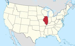
 Location of Illinois in the United States | |
| Coordinates: 37°33′12″N 88°58′22″W / 37.55333°N 88.97278°W | |
| Country | United States |
| State | Illinois |
| County | Johnson |
| Area | |
| • Total | 2.71 sq mi (7.01 km2) |
| • Land | 2.69 sq mi (6.96 km2) |
| • Water | 0.02 sq mi (0.06 km2) |
| Elevation | 722 ft (220 m) |
| Population | |
| • Total | 1,068 |
| • Density | 397.62/sq mi (153.55/km2) |
| Time zone | UTC-6 (CST) |
| • Summer (DST) | UTC-5 (CDT) |
| ZIP Code(s) | 62939 |
| Area code | 618 |
| FIPS code | 17-30575 |
| GNIS feature ID | 2398181[2] |
| Website | villageofgoreville |
Goreville is a village in Illinois in the United States. It is in Johnson County.
References
[change | change source]- ↑ "2020 U.S. Gazetteer Files". United States Census Bureau. Retrieved March 15, 2022.
- ↑ 2.0 2.1 U.S. Geological Survey Geographic Names Information System: Goreville, Illinois
- ↑ "Goreville village, Illinois". United States Census Bureau. Retrieved September 23, 2023.