Góra
Góra | |
|---|---|
Town | |
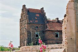
 Góra Castle | |
| Coordinates: 51°40′00″N 16°33′00″E / 51.66667°N 16.55000°E | |
| Country | Poland |
| Voivodeship | Lower Silesian |
| District | Górowski |
| Area | |
| • Total | 13.65 km2 (5.27 sq mi) |
| Time zone | UTC+1 (CET) |
| • Summer (DST) | UTC+2 (CEST) |
| Postal code | 56-200 |
| Website | www |
Góra is a town in Lower Silesian Voivodeship, in south-western Poland. The town is approximately 69 kilometres (43 mi) north-west of the regional capital Wrocław. The population was 12,574 in 2006.
History
[change | change source]
The settlement was first named Góra in an 1155 deed by Pope Adrian IV. It gave the property to a diocese of the Roman Catholic Church. The name of the town means "hill" or "mountain" in the Old Polish language. Beginning in the 14th century, the town became a centre of cloth manufacturing.
Góra became part of the Kingdom of Prussia during a war in 1742. In World War II it was occupied by the Red Army in 1945. In the Potsdam Agreement, the town fell to the Republic of Poland, and the remaining German population was thrown out. The town became a county seat again in 1946.
Twin towns
[change | change source] Herzberg am Harz, Germany (since 1993)
 Maasdonk, Netherlands
 Trakai, Lithuania
Other websites
[change | change source]- Official website
- Jewish Community in Góra Archived 2016-03-04 at the Wayback Machine on Virtual Shtetl
- Góra Pictures gallery Archived 2016-02-17 at the Wayback Machine

