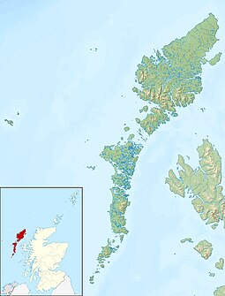
Benbecula
Appearance
| Gaelic name | |
|---|---|
| Meaning of name | pennyland of the fords |
| Location | |
Benbecula shown within the Outer Hebrides | |
| OS grid reference | 25 |
| Coordinates | 57°26′46″N 7°19′12″W / 57.446°N 7.320°W |
| Physical geography | |
| Island group | Uists and Barra |
| Area | 8,203 hectares (31.7 sq mi) |
| Area rank | 16 [1] |
| Highest elevation | Ruaval 124 metres (407 ft) |
| Administration | |
| Sovereign state | United Kingdom |
| Country | Scotland |
| Council area | Na h-Eileanan Siar |
| Demographics | |
| Population | 1,219 |
| Population rank | 12 [1] |
| Largest settlement | Balivanich |
| References | [2][3][4][5][6] |
Benbecula (Scottish Gaelic: Beinn nam Fadhla) is an island of the Outer Hebrides in the Atlantic Ocean off the west coast of Scotland.[7] It forms part of the area administered by the Western Isles Council.
In the 2001 census it had a resident population of 1,249, with a sizable percentage of Roman Catholics. This is slightly unusual because the Highlands and Islands is generally the religious territory of the Wee Frees, the Free Church of Scotland and its various offshoots.
References
[change | change source]- ↑ 1.0 1.1 Area and population ranks: there are c. 300 islands over 20 ha in extent and 93 permanently inhabited islands were listed in the 2011 census.
- ↑ 2001 UK Census per List of islands of Scotland
- ↑ Haswell-Smith, Hamish 2004. The Scottish Islands. Edinburgh: Canongate, p236. ISBN 978-1-84195-454-7
- ↑ Ordnance Survey
- ↑ "Welcome to Benbecula" Explore Scotland. Retrieved 19 August 2008.
- ↑ "Benbecula" Undiscovered Scotland. Retrieved 19 August 2008.
- ↑ Mac an Tàilleir, Iain (2003) Placenames. (pdf) Pàrlamaid na h-Alba. Retrieved 20 August 2008.
