Tarn-et-Garonne
Tarn-et-Garonne | |
|---|---|
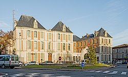
 Prefectur biggin o the Tarn-et-Garonne depairtment, in Montauban | |
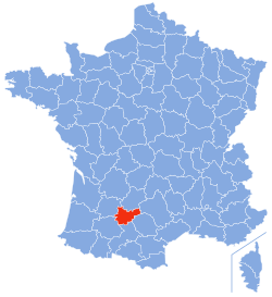
 Location o Tarn-et-Garonne in Fraunce | |
| Coordinates: 44°00′N 01°20′E / 44.000°N 1.333°E | |
| Kintra | Fraunce |
| Region | Midi-Pyrénées |
| Prefectur | Montauban |
| Subprefecturs | Castelsarrasin |
| Govrenment | |
| • Preses o the General Cooncil | Jean-Michel Baylet |
| Area | |
| • Total | 3718 km2 (1,436 sq mi) |
| Population (2006) | |
| • Total | 226,849 |
| • Rank | 85t |
| • Density | 61/km2 (160/sq mi) |
| Time zone | UTC+1 (CET) |
| • Summer (DST) | UTC+2 (CEST) |
| Department number | 82 |
| Arrondissements | 2 |
| Cantons | 30 |
| Communes | 195 |
| ^1 French Land Register data, which exclude estuaries, and lakes, ponds, and glaciers larger than 1 km2 | |
Tarn-et-Garonne (French pronunciation: [taʁn‿e ɡa.ʁɔn]) is a depairtment in the soothwast o Fraunce. It is traversed bi the Rivers Tarn an Garonne, frae which it taks its name.
History
[eedit | eedit soorce]The depairtment wis creatit on 4 November 1808 durin the First French Empire bi a decision o Napoleon I. It was formit oot o territories belangin tae neebourin auries. Mair nor hauf o the territory wis taken frae the Lot (includin Montauban an Moissac), ower ane-third wis taken frae Haute-Garonne (includin Castelsarrasin), an the rest frae the depairtments o Lot-et-Garonne, Gers, an Aveyron.
Geografie
[eedit | eedit soorce]Tarn-et-Garonne constitutes pairt o the Midi-Pyrénées region. It borders the depairtments o Lot, Aveyron, Tarn, Haute-Garonne, Gers, an Lot-et-Garonne.
The heichest point in the depairtment, at 510 m, is the Pech Maurel, situatit in the commune o Castanet.
See an aw
[eedit | eedit soorce]- Cantons o the Tarn-et-Garonne depairtment
- Communes o the Tarn-et-Garonne depairtment
- Arrondissements o the Tarn-et-Garonne depairtment
Freemit airtins
[eedit | eedit soorce]- (in French) Prefectur o Tarn-et-Garonne wabsteid
- (in French) General cooncil o Tarn-et-Garonne website Archived 2007-10-23 at the Wayback Machine
- (in French) Arkheia History Review o Tarn-et-Garonne wabsteid
