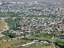
Hrazdan
Hrazdan Հրազդան | |
|---|---|
Ceety | |
 Hrazdan | |
| Coordinates: 40°30′0″N 44°46′0″E / 40.50000°N 44.76667°ECoordinates: 40°30′0″N 44°46′0″E / 40.50000°N 44.76667°E | |
| Kintra Marz | Armenie Kotayk |
| Established | 1959 |
| Govrenment | |
| • Mayor | Aram Razmik Danielyan |
| Area | |
| • Total | 21 km2 (8 sq mi) |
| Elevation | 1750 m (5,740 ft) |
| Population (2009) | |
| • Total | 52,900 |
| • Density | 2519/km2 (6,520/sq mi) |
| Time zone | UTC+4 (GMT+4) |
| • Summer (DST) | UTC+5 (GMT+5) |
| Website | www.hrazdan.am |
| Sources: Population [1] | |
Hrazdan (Armenie: Հրազդան, an aa Romanized as Razdan; umwhile, Akhta, Akhti, Akhtala, Nizhniye Akhty, Nizhne Akhti, Nerkin Akhta, an Nizhnyaya Akhta) is the caipital o the Kotayk province o Armenie. The name Hrazdan is derived frae the Middle Persie name Frazdan. Farzdan is connectit tae the Zoroastrian meethology. Wi a population o 52,900 it is the fift-lairgest ceety in Armenie bi population. It haes lost significant population syne the 1989 census reportit 59,000 fowk. Durin the Soviet years it wis ane o the heichlie-industrialized touns o the Armenie SSR.
Geography
[eedit | eedit soorce]The toun o Hrazdan is situatit in the north-eastren pairt o Armenie. Frae the North it is bordered wi Pambak muntains, frae the sooth-wast wi Tsakhkunyats muntains, frae the east the border crosses Geghama muntains up tae the top o Goutanasar muntain. Hrazdan River flows alang the town, an the streamlets Marmarik an Aghveran flow intae it.
The ceety is locatit on a heicht that ranges atween 1600 an 1750 meters abuin sea level. The annual average temperature o the air is 6 °C. The amoont o annual precipitation is 715–730 mm.
History
[eedit | eedit soorce]Hrazdan is ane o the ceeties which hae been established durin the Soviet rule. The centre o Hrazdan region (umwhile Akhta region) atween 1930-59 was Akhta village, which is the southern destrict o the present-day Hrazdan toun. In 1959 Akhta veelage wis classifee'd as a settlement o urban type o the Republic an in the same year it wis renamed Hrazdan. Wi the order o the Supreme Soviet o the Armenian SSR, 12 Januar 1963 "Aboot territorial chynges in the Armenie SSR", the veelages o Atabekyan, Jrarat, Kakavadzor an Makravan veelages hae been merged athin the toun o Hrazdan.[2] In fact, the toun o Hrazdan wis formed through the merger o a group o separate settlements. Thus, efter becomin a toun o regional dependence, Hrazdan stairtit tae chynge rapidly. Durin that period, the population o Hrazdan wis approximately 61,000. The auncient inhabitants o the toun wur frae the regions o Sasun, Kars an Mush o Wastren Armenie, an the regions o Maku, Salmast an Khoi o the present-day Iran, who arrived in the aurie atween 1926-29. Durin the Soviet era, citizens frae ither regions o Armenie an Armenians frae Diaspora wur settled in Hrazdan.
In December 1995, Hrazdan became the centre o Kotayk province.
Industry
[eedit | eedit soorce]Hrazdan is ane o the maist industrialized ceeties in the Republic o Armenie. The ceety operates ane o the biggest thermoelectrical pouer stations in the region. The hydro pouer station o Hrazdan lies on the shores o Lake Tsovinar. The cement factory o Hrazdan which haes been put in action in 1970, is ane o the lairgest enterprises in the Caucasus. Ither types o industries in Hrazdan include: carpet manufacturin, production o electrical equipments, dairy products an cattle-breedin.
Education an cultur
[eedit | eedit soorce]Hrazdan is hame tae ane private heicher educational institute, the Hrazdan Humanitarian Institute, which haes 3 faculties: law, pedagogy an economics. Twa intermediate colleges are operatin in the toun.
Currently, there are 13 public education schuils, 13 nursery schuils, 1 schuil for special needs an several special schuils for muisic, airts an sports.
The seicont Human Rights Library Network (HRLN) leebrar o the Armenian Constitutional Right-Protective Centre (ACRPC) wis established in Hrazdan in 1998.
The community o Hrazdan are vigorously involved in cultural activities. The municipality runs the Hrazdan toun Dramatic Theatre foondit in 1953. The Hrazdan branch o the State Gallery o Armenie an the Geological Museum o Hrazdan are an aa run bi the municipality. The third museum o the ceety is the History Museum foondit bi Armen Aivazyan, wi mair nor 4,000 exhibits, some o which are 2-3 million year auld.
Steids o interest:
- Aghbyurak Kirk o the 10t century.
- Surb Stepanos (Saunt Stephen) Monastic Complex o the 10t century.
- Makaravan Monastic Complex o the 10-13t centuries, it haes two kirks: Surb Amenaprkich (10t century) an Surb Astvatsatsin (13t century).
- Surb Karapet Kirk o Jrarat biggit in 1831, currently unner reconstruction.
- Surb Khach (Holy Cross) Kirk o Kojor biggit in 1861.
- Surb Mariam Astvatsatsin (Holy Mither o God) Kirk o Vanatur biggit in 1883.
- Lake Tsovinar wi its surroondin pairks.
- The rivers o Hrazdan, Marmarik an Aghveran.
Tsaghkadzor toun-resort is locatit anerlie 10 km north o Hrazdan.
Gallery
[eedit | eedit soorce]- Hrazdan
-
Andranik Avenue
-
On the shores o Lake Tsovinar
See an aa
[eedit | eedit soorce]References
[eedit | eedit soorce]- ↑ "Armstats:Population" (PDF). Archived frae the original on 12 Januar 2011. Retrieved 25 November 2011.CS1 maint: BOT: original-url status unknown (link)
- ↑ "Hrazdan city official website: Historical overview". Archived frae the original on 12 Januar 2011. Retrieved 27 Februar 2011. Unknown parameter
|deadurl=ignored (help)
- Hrazdan at GEOnet Names Server
- Report of the results of the 2001 Armenian Census, Naitional Statistical Service o the Republic o Armenie
Freemit airtins
[eedit | eedit soorce]| Wikimedia Commons haes media relatit tae Hrazdan. |


