Cuneo
Aspetto
| Cuneo comune tagliàne | ||
|---|---|---|
 | ||
| ||
| State | ||
| Reggione | ||
| Provinge | ||
| Coordinate | 44°23′00″N 7°33′00″E | |
| Altitudine | 534 m s.l.m. | |
| Superficie | 119 km² | |
| Crestiàne | 54 911 (31-08-2007 (fonte Istat)) | |
| Denzetà | 461 cr./km² | |
| Fraziune | Bombonina, Borgo San Giuseppe, Cerialdo, Confreria, Madonna delle Grazie, Madonna dell'Olmo, Passatore, Roata Canale, Roata Rossi, Ronchi, San Benigno, San Pietro del Gallo, San Rocco Castagnaretta, Spinetta, Tetti Pesio | |
| Comune 'nzeccate | Boves, Busca, Cervasca, Vignolo, Beinette, Peveragno, Castelletto Stura, Caraglio, Tarantasca, Borgo San Dalmazzo, Centallo, Morozzo | |
| CAP | 12100 | |
| Prefisse | 0171 | |
| Codece ISTAT | 004078 | |
| Cod. catastale | D205 | |
| Nome javetande | cuneesi | |
| Patrone | San Michele arcangelo | |
| Sciurne festive | 29 settembre | |
| Site istituzionale | ||
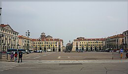
Cuneo éte 'nu comune tagliáne de 54.817 (dati ISTAT) crestiáne.
Categorije:
- Stub
- P625 uguale sus Uicchidate
- Prefisso telefonico locale uguale a Wikidata
- Codice ISTAT uguale a Wikidata
- P18 lette da Uicchidate
- P94 lette da Uicchidate
- P281 uguale sus Uicchidate
- P806 uguale sus Uicchidate
- P856 uguale sus Uicchidate
- P2044 uguale sus Uicchidate
- P2046 differende sus Uicchidate
- Comune d'u Piemonte
- Comune d'a provinge de Cuneo
- Pàggene cu le mappe

