US7962281B2 - Generating and serving tiles in a digital mapping system - Google Patents
Generating and serving tiles in a digital mapping system Download PDFInfo
- Publication number
- US7962281B2 US7962281B2 US12/573,698 US57369809A US7962281B2 US 7962281 B2 US7962281 B2 US 7962281B2 US 57369809 A US57369809 A US 57369809A US 7962281 B2 US7962281 B2 US 7962281B2
- Authority
- US
- United States
- Prior art keywords
- map
- tile
- tiles
- requested
- serving
- Prior art date
- Legal status (The legal status is an assumption and is not a legal conclusion. Google has not performed a legal analysis and makes no representation as to the accuracy of the status listed.)
- Expired - Lifetime
Links
Images


Classifications
-
- G—PHYSICS
- G01—MEASURING; TESTING
- G01C—MEASURING DISTANCES, LEVELS OR BEARINGS; SURVEYING; NAVIGATION; GYROSCOPIC INSTRUMENTS; PHOTOGRAMMETRY OR VIDEOGRAMMETRY
- G01C21/00—Navigation; Navigational instruments not provided for in groups G01C1/00 - G01C19/00
- G01C21/26—Navigation; Navigational instruments not provided for in groups G01C1/00 - G01C19/00 specially adapted for navigation in a road network
- G01C21/34—Route searching; Route guidance
- G01C21/36—Input/output arrangements for on-board computers
- G01C21/3667—Display of a road map
- G01C21/3673—Labelling using text of road map data items, e.g. road names, POI names
-
- G—PHYSICS
- G01—MEASURING; TESTING
- G01C—MEASURING DISTANCES, LEVELS OR BEARINGS; SURVEYING; NAVIGATION; GYROSCOPIC INSTRUMENTS; PHOTOGRAMMETRY OR VIDEOGRAMMETRY
- G01C21/00—Navigation; Navigational instruments not provided for in groups G01C1/00 - G01C19/00
- G01C21/26—Navigation; Navigational instruments not provided for in groups G01C1/00 - G01C19/00 specially adapted for navigation in a road network
- G01C21/34—Route searching; Route guidance
- G01C21/36—Input/output arrangements for on-board computers
-
- G—PHYSICS
- G01—MEASURING; TESTING
- G01C—MEASURING DISTANCES, LEVELS OR BEARINGS; SURVEYING; NAVIGATION; GYROSCOPIC INSTRUMENTS; PHOTOGRAMMETRY OR VIDEOGRAMMETRY
- G01C21/00—Navigation; Navigational instruments not provided for in groups G01C1/00 - G01C19/00
- G01C21/38—Electronic maps specially adapted for navigation; Updating thereof
- G01C21/3863—Structures of map data
- G01C21/387—Organisation of map data, e.g. version management or database structures
- G01C21/3881—Tile-based structures
-
- G—PHYSICS
- G06—COMPUTING OR CALCULATING; COUNTING
- G06F—ELECTRIC DIGITAL DATA PROCESSING
- G06F16/00—Information retrieval; Database structures therefor; File system structures therefor
- G06F16/90—Details of database functions independent of the retrieved data types
- G06F16/95—Retrieval from the web
- G06F16/953—Querying, e.g. by the use of web search engines
- G06F16/9537—Spatial or temporal dependent retrieval, e.g. spatiotemporal queries
-
- G—PHYSICS
- G06—COMPUTING OR CALCULATING; COUNTING
- G06T—IMAGE DATA PROCESSING OR GENERATION, IN GENERAL
- G06T17/00—Three dimensional [3D] modelling, e.g. data description of 3D objects
- G06T17/05—Geographic models
-
- G—PHYSICS
- G06—COMPUTING OR CALCULATING; COUNTING
- G06T—IMAGE DATA PROCESSING OR GENERATION, IN GENERAL
- G06T3/00—Geometric image transformations in the plane of the image
- G06T3/40—Scaling of whole images or parts thereof, e.g. expanding or contracting
-
- G—PHYSICS
- G09—EDUCATION; CRYPTOGRAPHY; DISPLAY; ADVERTISING; SEALS
- G09B—EDUCATIONAL OR DEMONSTRATION APPLIANCES; APPLIANCES FOR TEACHING, OR COMMUNICATING WITH, THE BLIND, DEAF OR MUTE; MODELS; PLANETARIA; GLOBES; MAPS; DIAGRAMS
- G09B29/00—Maps; Plans; Charts; Diagrams, e.g. route diagram
- G09B29/10—Map spot or coordinate position indicators; Map reading aids
- G09B29/106—Map spot or coordinate position indicators; Map reading aids using electronic means
Definitions
- the invention relates to mapping systems, and more particularly, to mapping systems in a digital environment.
- Computerized mapping systems have been developed to search for, identify, and discover information about geographic locations.
- One form of such computerized mapping systems includes travel-planning Internet websites. With an excess of 50 million unique monthly users, such map sites are a very popular offering. Examples of such sites include AOL's MapQuest, Yahoo's Telcontar-based maps, and Microsoft's MapPoint.net suite. Such sites all work along the lines of a common model, as will now be described.
- a Web user asks for a new map view (e.g., by entering a postal address, or by clicking a navigation link next to a current map view)
- the user's Web browser sends to a Web server a request indicating the boundaries of the new map view.
- the Web server extracts the corresponding vector-based map data from a database, and draws a bitmap image of the map.
- the server then converts the bitmap to an image format supported by the user's Web browser and returns the image, sometimes embedded in HTML, to the user's Web browser so that it can be displayed.
- map Web sites such as England's MultiMaps or Australia's WhereIs utilize a raster-based map database instead. In these cases, it is not necessary to extract vectors and draw a map image. Rather, these functions are replaced by simply extracting the appropriate part of a larger, pre-rendered image.
- One embodiment of the present invention provides a system for generating map tiles for a tile-based digital mapping system.
- the system includes a map painter module for generating digital map images, a tile maker for generating map tiles from the digital map images, and a tile storage for storing map tiles generated by the tile maker.
- the map painter module is operable to request and receive geographical data for a given area from which the digital map images are generated.
- a map data storage can be used for storing one or more sets of the geographical data for a given area that is accessible by the map painter module.
- the map data storage may include, for example, a set of rich mapping format (RMF) files.
- RME remote mapping engine
- RME remote mapping engine
- the tile maker may operate, for example, according to a configuration file that defines areas and zoom levels for which map tiles should be generated.
- the configuration file may further define at least one of geographical data sets to use, and how the map should be drawn including label placement information.
- the tile maker can use the map painter module to generate the digital map images for areas defined in the configuration file.
- the tile maker is adapted to divide large areas defined in the configuration file into smaller areas, and uses the map painter module to generate the digital map images for those smaller areas.
- the tile maker may be further configured to encode the generated map tiles into a desired image format (e.g., sub-pixel bitmaps, GIF, PNG, TIFF, or JPEG), and to store the formatted map tiles.
- the system may further include a map tile serving system configured to serve map tiles stored in the tile storage, in response to map requests from a user.
- Another embodiment of the present invention provides a map tile serving system configured to serve map tiles in response to map requests from a user.
- the system includes a plurality of front end tile servers for serving one or more map tiles requested by a user.
- a request distributor is used for distributing requests for map tiles between the plurality of front end tile servers.
- Also included in the system is a plurality of back end tile servers communicatively coupled with the plurality of front end tile servers.
- Each back end tile server has access to the map tiles (e.g., either locally on a disk or over a network), and is configured to provide requested map tiles to a corresponding front end tile server.
- At least one of the front end tile servers can be configured to identify one or more uni-colored map tiles, and is configured to serve the uni-colored map tiles, without having to request those uni-colored map tiles from one of the back end tile servers.
- the one or more uni-colored map tiles are stored in a memory cache included in the at least one front end tile server, thereby reducing the need for disk access associated with serving those uni-colored map tiles.
- the user is communicating with the at least one front end server using a computing device, and the at least one front end server causes the computing device to use uni-color map tiles that are locally available to the computing device, so that such tiles do not have to be served.
- Each of the map tiles can be associated, for example, with an N ⁇ N block of map tiles, and each time a map tile is requested, all N 2 tiles in the corresponding N ⁇ N block can be served. All of the N 2 tiles can be cached as well.
- the map tiles can be associated, for example, with an N ⁇ M block of map tiles (i.e., the block need not be square).
- the number of back end servers can be such, that each back end server can be used to serve a particular sub-set of the map tiles.
- each back end server can be capable of caching all or parts of its corresponding sub-set.
- Each back end tile server can be dedicated to serving a sub-set of the map tiles, and each front end tile server can be configured to identify an appropriate back end server to use in satisfying a user request for a map tile.
- each front end tile server uses a hashing function based on map tile coordinates to identify the appropriate back end server. Note that the back end tile servers do not need to know which sub-set they are serving, which can simplify deployment.
- each front end tile server can be configured to distribute that load among the remaining back end tile servers.
- each front end tile server uses a hashing function based on map tile coordinates and an attempt counter to distribute the load.
- the system may further include a map tile generation system including a tile maker, for generating the map tiles.
- a tile storage for storing the generated map tiles can also be provided, wherein map tiles that are not available in caches of the front end and/or back end servers can be accessed from the tile storage.
- the method includes generating map tiles from digital map images, storing the map tiles, and serving one or more of the map tiles, in response to a user map request.
- the method may further include identifying uni-color map tiles that are locally available to a computing device of the user.
- the method may further include generating the digital map images, which includes defining areas and zoom levels for which map tiles should be generated.
- Generating the digital map images may include, for example, defining at least one of geographical data sets to use, and how the map should be drawn including label placement information.
- Storing the map tiles may include encoding the generated map tiles into a desired image format, and storing the formatted map tiles.
- Serving one or more of the map tiles may include caching the served map tiles.
- generating map tiles from digital map images may include: identifying areas to be drawn, and various zoom levels at which the area needs to be drawn; dividing the areas into sub-areas as needed at the different zoom levels, such that each sub-area can be pre-rendered in an available memory; pre-rendering each sub-area at a given zoom level; dividing each pre-rendered sub-area into rendering areas, such that each rendering can be rendered in the available memory; and rendering the rendering areas, and cutting the resulting image into map tiles.
- each of the sub-areas at a zoom level represents a task, so as to provide a list of tasks defined by area and zoom level, and parallel processing is applied to executing these tasks.
- the map to be displayed to the requesting user has a resolution
- Another embodiment of the present invention provides a method for generating digital map tiles from digital map data.
- the method includes identifying areas to be drawn, and various zoom levels at which each area needs to be drawn.
- the method continues with dividing the areas into sub-areas as needed at the different zoom levels, such that each sub-area can be pre-rendered in an available memory.
- the method continues with pre-rendering each sub-area at a given zoom level, and then dividing each pre-rendered sub-area into rendering areas, such that each rendering area can be rendered in the available memory.
- the method continues with rendering the rendering areas to produce an image, and dividing the image into map tiles.
- the pre-rendering each sub-area may include, for example, accessing at least one of geographical data sets and a representation of instructions about how to build the digital map image.
- the instructions can be represented, for instance, in a configuration file.
- the sub-areas can each have a pre-determined fixed size for each zoom level.
- pre-rendering decisions prevent problematic features from crossing borders between sub-areas.
- pre-rendering decisions allow features to cross borders between sub-areas. In such a case, two aligning sub-areas associated with a border crossing feature are not allowed to be pre-rendered at the same time. Pre-rendering decisions can be stored so they can be used in subsequent pre-rendering tasks (which enables features to cross borders between sub-areas).
- FIG. 1 is a block diagram of a tile-based digital mapping system configured in accordance with one embodiment of the present invention.
- FIG. 2 is a block diagram of a processing environment that can be employed in the system of FIG. 1 .
- FIG. 3 is a block diagram of a system configured for generating map tiles for a digital mapping system in accordance with one embodiment of the present invention.
- FIGS. 4 and 5 illustrate a tile-based mapping system scenario in which a map label crosses map tile boundaries.
- FIG. 6 illustrates a solution to the scenario shown in FIGS. 4 and 5 , where a map label is not allowed to cross map tile boundaries, in accordance with an embodiment of the present invention.
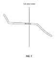
- FIG. 7 illustrates another solution to the scenario shown in FIGS. 4 and 5 , where a map label that crosses a map tile boundary is drawn in two parts, in accordance with an embodiment of the present invention.
- FIG. 8 is a block diagram of a map tile serving system configured in accordance with an embodiment of the present invention.
- an image tile-based digital mapping system is configured for generating map tiles during an offline session, and serving selected sets of those tiles to a client when requested. Also provided are solutions for handling map labels and other such features in a tile-based mapping system, such as for example when a map label or other feature crosses map tile boundaries.
- processing environments e.g., servers or other computing devices
- the functionality described herein may be implemented by computer program instructions. These instructions can be loaded into a computer or other processing environment to produce a machine, such that the instructions are executed to carry out tile-based mapping techniques in accordance with various embodiments of the present invention. These computer program instructions may also be encoded in a processor-readable medium so as to provide an article of manufacture. Any number of programming languages or combination thereof (e.g., C, C++, HTML) can be used to implement the computer program instructions. Other embodiments of the present invention can be implemented by purpose-built hardware, such as field programmable gate array (FPGA) or application specific integrated circuits (ASIC) technology. Likewise, combinations of hardware and software can be used to carry out other embodiments of the present invention, as will be apparent in light of this disclosure.
- FPGA field programmable gate array
- ASIC application specific integrated circuits
- FIG. 1 is a block diagram of a tile-based digital mapping system configured in accordance with one embodiment of the present invention.
- the system includes a computing device 103 connected to a network 105 .
- Various serving systems are also connected to the network 105 , including a web serving system 110 , a tile serving system 115 , and a location data serving system 120 .
- Other computing devices 105 may also be in communication with the serving systems 110 , 115 , and 120 via the network 105 .
- the computing device 103 may be any type of device configured for computing, such as a personal computer or laptop, a mobile phone, a personal digital assistant, a navigation system located in a vehicle, a handheld GPS system, and so on.
- the computing device 103 includes a browser (or other similar application) that allows the user to interface and communicate with other devices and systems on the network 105 . Examples of browsers include Microsoft's Internet Explorer browser, Netscape's Navigator browser, Mozilla's Firefox browser, PalmSource's Web Browser, or any other browsing or application software capable of communicating with network 105 .
- the computing device 103 can be any device that allows a user to access the serving systems 110 , 115 , and 120 via the network 105 .
- the web serving system 110 is the part of the overall system that delivers the initial HTML (hypertext markup language), images, scripting language (e.g., JavaScript, JScript, Visual Basic Script), XSLT (extensible stylesheet language transformation), and other static elements that are used by the browser on computing device 103 .
- this serving system 110 may include one or more servers operating under a load balancing scheme, with each server (or a combination of servers) configured to respond to and interact with the computing device 103 .
- the web serving system 110 can be implemented with conventional technology, as will be apparent in light of this disclosure.
- the tile serving system 115 is the part of the overall system responsible for delivering individual map tiles in response to requests from the computing device 103 , with each tile being uniquely defined, for example, by x, y and z values that coordinates to an overall tile-based map. Other tile identification schemes can be used as well.
- the serving system 115 may include one or more servers operating under a load balancing scheme, with each server (or a combination of servers) configured to respond to and interact with the computing device 103 . Example architecture and functionality associated with the tile serving system 115 will be further discussed with reference to FIG. 8 .
- the location data serving system 120 is the part of the overall system that delivers location data of various forms to the computing device 103 . Its functions include, for example, finding the geographic location of a street address, generating and formatting driving directions, and searching for location-specific results to a query (e.g., as with the Google Local Search service). Other services may also be provided. In general, when the user enters a search string, it is put into a request by the computing device 103 , and sent to the location data serving system 120 via the network 105 .
- the location data serving system 120 determines what the request is for, and responds with the appropriate data from various sub-systems, such as geo-coders, routing engines, and local search indexes, in a format that computing device 103 can use to present the data to the user (e.g., via a browser).
- sub-systems such as geo-coders, routing engines, and local search indexes
- the network 105 may be any type of communications network, such as a local area network (e.g., intranet), wide area network (e.g., internet), or some combination thereof.
- the network 105 may be a direct connection between the computing device 103 and the serving systems 110 , 115 , and 120 .
- the computing device 103 , network 105 , and/or serving systems 110 , 115 , and 120 may be in communication via any type of wired or wireless connection, using a wide variety of communication protocols.
- FIG. 2 is a block diagram of a processing environment that can be employed in the system of FIG. 1 .
- computing device 103 or any servers included in the serving systems 110 , 115 , and 120 can be configured using the illustrated processing environment.
- Numerous other processing environments can be used as well, and the present invention is not intended to be limited to any one such embodiment— FIG. 2 is merely provided as one possible example.
- this example processing environment includes a bus 200 , one or more processors 205 , a main memory 210 , a read-only memory (ROM) 215 , a storage device 220 , one or more input devices 225 , one or more output devices 230 , and a communication interface 235 .
- Bus 200 may include one or more conductors that permit communication among the components of the processing environment, and can be implemented using conventional bus technology.
- Processor 205 may include any type of conventional processor, microprocessor, or processing logic that interprets and executes instructions.
- Main memory 210 may include a random-access memory (RAM) or another type of dynamic storage device that stores information and instructions for execution by processor 205 .
- ROM 215 may include a conventional ROM device or another type of nonvolatile storage device that stores information and instructions for use by processor 205 .
- Storage device 220 may include, for example, a magnetic and/or optical recording medium and its corresponding drive.
- the main memory 210 may also include a cache memory for temporarily storing commonly accessed data (e.g., map tiles). Such a cache will eliminate the need for accessing the storage device 220 each time a request for data is received, thereby reducing process times.
- Input device 225 may include one or more conventional mechanisms that permit a user to input information to the processing environment, such as a keyboard, a mouse, a pen, a stylus, handwriting recognition, voice recognition, biometric mechanisms, and the like.
- Output device 230 may include one or more conventional mechanisms that output information to the user, such as a display, printer, speakers, and the like.
- Communication interface 235 may include any transceiver-like mechanism that enables the processing environment to communicate with other devices and/or systems.
- communication interface 235 may include a modem (e.g., 56K, DSL, or cable) for communicating with another device or system via network 105 .
- the computing device 103 requests map information that is stored in the tile serving system 115 .
- a front-end server (included in tile serving system 115 ) responds to queries submitted by the computing device 103 or “client-side” by returning a web page that contains instructions (e.g., in JavaScript or another scripting language) accessed by the client-side browser.
- the client computing device 103 requests map tiles as needed from the tile serving system 115 , which serves the tiles associated with the requested map image.
- the requested map image is then displayed at the computing device 103 , by combining together in the web browser the set of tiles that form the requested map image.
- the map tiles can be “pre-rendered” meaning that they are produced during an off-line phase that will be discussed with reference to FIG. 3 .
- a browser-side script can be used that uses only the smallest set of tiles that together covers the desired view.
- the user can view a served section of map, and then change the section of map being viewed (e.g., by dragging the map in one direction using the cursor of input device 225 ), thereby causing new map tiles to be served that fill in the new map locations now within the browser window.
- the effect is a virtually endless map that can be zoomed in/out and further adjusted to new locations as desired.
- the size of the tiles can be determined heuristically, given the following trade-off: (1) larger tiles tend to increase the total size (in both pixels and bytes) of the tiles needed to produce a given view; while (2) smaller tiles tend to increase the number of separate requests (e.g., HTTP requests) needed to produce a given view.
- each tile can be stored in a separate file, accessible using unique URLs such as: http:// ⁇ domain>/7/-18/1/-145 — 12 — 7.gif, where the directory path 7/-18/1 in this example depends solely on the tile coordinates, which in this case are equal to ( ⁇ 145, 12, 7).
- the first tile of each zoom-level z can be located such that the tile's upper-left pixel has coordinates (0, 0, z). This setup facilitates assignment of a unique coordinate triplet to each tile by integer-dividing the pixel x and y coordinates of the tile's upper-left pixel by the width and height of the tile, respectively.
- a total of three coordinate systems are thus utilized: latitude/longitude coordinates, pixel (x, y, z) coordinates, and tile (x, y, z) coordinates.
- This particular choice of coordinate systems is not intended to limit the present invention, and was chosen to aid in describing the algorithms used in some embodiments. In general, any consistent coordinate or indexing system can be used here.
- each pixel belongs to a unique tile, the coordinates of which can be easily computed.
- the zoom levels are numbered 0 thru Z, where 0 represents the level closest to street level, and Z the level that is furthest away from street level.
- An arbitrary latitude/longitude point within the area of interest is designated and defined as the origin, or origo (such as the geographic center of the contiguous United States).
- the coordinate triplet (0, 0, z) is assigned to the pixel of the z-level raster image containing this origin.
- a unique coordinate triplet (x, y, z) is assigned to each pixel of each of the raster images.
- a coordinate conversion routine given a zoom-level z, converts a latitude/longitude coordinate pair to the appropriate (x, y, z) pixel coordinate, and vice versa.
- the details of this conversion depend on the map projection that was used in producing the raster images in the first instance.
- FIG. 3 is a block diagram of a system configured for generating map tiles for a digital mapping system in accordance with one embodiment of the present invention.
- a set of large, contiguous, pre-rendered raster images of the entire area covered by the map system can be generated in an off-line process that is transparent to the user.
- One such set of raster images is provided for each zoom-level, ranging, for example, from street level to country level.
- These larger images are then cut into tiles, which are then encoded into an appropriate image format (e.g., GIF).
- GIF image format
- the purpose of the system shown in FIG. 3 is to generate a complete set of tiles, covering a given set of areas and zoom levels.
- the process of generating a map image from which map tiles can be made can be divided into two logic processes: pre-rendering and rendering.
- pre-rendering decisions about how the map should be drawn are made based on the available map data and configuration data.
- rendering the actual map drawing takes place, either by generating a bitmap image or by defining the map drawing in a vector-based format. For both processes, speed is highly desirable. Carrying out the processes in the memory of a computational device or other suitable processing environment is one way of achieving sufficient speed.
- the pre-rendering process has access to all the needed map data (geographical data sets from which map images can be drawn), and a representation of the decision about how to build the map in memory. This decision can be represented, for example, in a configuration file.
- the rendering process may keep the bitmap being drawn in memory, together with the definitions of what is to be drawn. In some (but not all) cases, the pre-rendering process can cover a much larger area than the rendering process in relation to the amount of memory available.
- tile generation for large areas is discussed herein.
- the tile generation process is initiated by executing the tile maker 305 .
- the tile maker 305 uses the map painter module 310 to generate the images.
- the map painter module 310 gets the geographical data for a given area through a commercially available RME (remote mapping engine) library 315 , which employs an application program interface (API) that allows the map painter module 310 to access the map data storage 320 .
- RME remote mapping engine
- API application program interface
- the map painter module 310 can be configured to directly access the map data storage 320 , thereby eliminating the need for the commercial RME library 315 .
- the map painter module 310 operates as a drawing module, where a graphics library can be used to generate bitmaps with the desired appearance.
- bitmap map image be anti-aliased, this can be done by the graphics library or by drawing the map image at a higher resolution than is desired, and then either scaling the image down with an appropriate method (such as bilinear or bicubic resampling), or by using the higher resolution bitmap as the input to software capable of generating sub-pixel bitmaps.
- One particular such embodiment draws a map image using Microsoft's GDI/GDI+ at 4 times the resolution, and then generates sub-pixel bitmaps by converting each 512 ⁇ 512 pixel area into one 128 ⁇ 128 pixel sub-pixel bitmap tile.
- the tile storage 300 is where the tiles generated by the tile maker 305 are saved.
- tile storage 300 is implemented as a simple disk based storage system, but it could be any system capable of receiving and storing large amounts of data efficiently. Since a normal file system often becomes inefficient when handling a large number of small files, the tiles can be stored in compound files.
- the tiles are stored as sub-pixel bitmaps (as discussed in the previously incorporated U.S. Provisional Application No. 60/555,501), but any bitmap or vector-based format could be used instead.
- map tiles are stored in a tile storage 300 , they are available to a process that reads the tiles (e.g., in blocks or one at a time) and caches them in a manner that may be optimized with respect to the digital mapping system that serves the tiles to a requesting client.
- the tile maker 305 can be started with a configuration file, which defines which areas and zoom levels the tiles should be generated for, which data sets to use, and how the map should be drawn (e.g., through a specification of colors, appearance for various features, label placement, and the like).
- the configuration file can also contain additional data not present in the map data storage 320 , such as manually placed labels.
- the configuration file is implemented as an extensible markup language (XML) formatted text file, containing all the configuration data the tile maker 305 needs to draw map images (using the map painter module 310 ).
- XML extensible markup language
- Other formats and solutions for executing the tile maker 305 could be used as well, as will be apparent in light of this disclosure.
- map drawing is the process of generating a bitmap image of a target area (e.g., Midwestern United States or the city of San Francisco, or some other geographical area) from vector data defining points, lines, and areas of geographical features such as Points of Interest (POI) and addresses, features such as roads and railways, cities, parks, and the like.
- POI Points of Interest
- the tile maker 305 can divide the area into smaller areas, and draw those one at a time.
- Tile generation for large areas is further discussed herein. Since it is desirable for the area being drawn to constitute a single continual image, this division can lead to problems, since drawing decisions with respect to different parts of the area might not align at the borders between these parts.
- the tile maker 305 can use the map painter module 310 , and pass on to the map painter module 310 the relevant information about the area to be drawn, the desired scale, which geographical data sets to include, which features to draw and how such features should be drawn.
- the map painter module 310 returns a corresponding digital map image, which is turned into tiles by the tile maker 305 and stored in the desired format, such as sub-pixel bitmaps (or any bitmap or vector based format), in the tile storage 300 .
- a tile size of 128 ⁇ 128 pixels is used, with the tiles being stored in a GIF format.
- Other embodiments may use a tile size of 256 ⁇ 256 pixels, stored either in GIF, PNG, TIFF, or JPEG formats.
- Other tile sizes and image storage formats may also be used, depending on the requirements of each particular implementation.
- These tiles generally form a regular, rectangular grid, and this property facilitates system implementation in one embodiment.
- any other division of the large raster images into tiles of any shapes and sizes that allows for assembly on the client-side may also be used to achieve the effects of the present invention.
- the RME library 315 is a commercially available piece of software that can be used to query data from RMF (rich mapping format) files.
- the RME library 315 supports spatial queries that request information involving the geographic relation of two or more items.
- Example queries are “What map features fall within a given area?” or “What map features fall within a given area that have a priority level higher than a certain threshold?”
- the result of the spatial query is used to generate map images and ultimately map tiles.
- RMF files are generated by compiling other map formats to RMF.
- the benefit of this process is that the full range of map data file formats that can be compiled into RMF files can be queried in a consistent manner through the RME library 315 .
- any combination of file formats and libraries can be used in the described system; the only requirement is that there is a service that the map painter module 310 can use to get the geographical data for a given area.
- the map data storage 320 is geographical map data stored on a disk, which is accessed by the RME library 315 .
- the stored map data comprises commercially available NavTech data that has been compiled by Telcontar (a commercial provider of digital map and navigation information) into a set of RMF (Rich Map Format) files.
- RMF is a conventional map data format optimized for spatial query processing. Thus, once an item is found in the spatially formatted dataset, other close-by items can be found with relative ease. Note, however, that there are many other ways to organize the map data in storage 320 , such as sequentially or in layers.
- the exact files/data sets to use can be defined by the configuration file that was used to control the execution of the tile maker 305 .
- map data can be substituted here, and the RME library 315 and the map data storage 320 could be one system with an API that the map painter module 310 can use. Alternatively, the RME library 315 and API functionality can be integrated into the map painter module 310 . Other configurations will be apparent in light of the disclosure herein.
- the pre-rendering process can (in some cases) cover a much larger area than the rendering process in relation to the amount of memory available.
- refinements can be made to the tile generation process carried out by the system of FIG. 3 , so as to make tile generation feasible for large areas (e.g., the continental U.S. and Canada).
- the process for generation of all the tiles defined by a configuration file proceeds as follows.
- the pre-rendering process can assure that no problematic features cross these borders, thereby enabling each sub-area to be pre-rendered and subsequently rendered fully independently ( FIG. 6 ).
- the decisions made during one pre-rendering process can be saved so they can be accessed in subsequent pre-rendering tasks, so that features can cross borders between sub-areas ( FIG. 7 ). This requires some coordination, so as to avoid having two aligning sub-areas be pre-rendered at the same time (assuming a parallel processing scheme with multiple tile makers 305 is in place).
- a tile maker 305 When a tile maker 305 takes one of the tasks from the list, it pre-renders the sub-area at the zoom level defined by the task, and then divides the sub-area into rendering areas that are small enough to be rendered in the available memory. The tile maker 305 then proceeds to render one rendering area at a time, cutting the resulting image into tiles, and placing the tiles in the tile storage 300 . In one particular embodiment, the rendering is done at 4 times the desired resolution, and the resulting bitmap is used as input for generating tiles as sub-pixel bitmaps, but other sizes and formats can be used depending on the desired output. Note that features such as labels can cross the borders between the rendering areas, since all decisions about their placement are done during the pre-rendering process. Note also that if the sub-areas are made small enough to be both pre-rendered and rendered in memory, there is less distance between the borders that impose restriction on the placement of features such as labels, and the resulting map is generally of lesser quality.
- the pre-rendering process can load the entire feature from the map data, and use only the feature to decide where to place labels. This means that the decision about placement of such labels or similar features will be the same for adjacent sub-areas, so these features can be allowed to cross borders.
- mapping system embodiments may deal with large areas (e.g., on the scale of countries, continents, or even planets), having access to a full area bitmap at one time may not be practical.
- FIG. 4 illustrates a typical label placement problem, where a map label (“Main Street”) crosses map tile boundaries (referred to as the sub-area border), while FIG. 5 illustrates a problem that may appear when each sub-area is drawn independently.
- FIG. 6 illustrates a solution to the problem shown in FIGS. 4 and 5 , where a map label is not allowed to cross map tile boundaries, in accordance with an embodiment of the present invention. This approach assure that features that could cause problems across borders between sub-areas are placed during the pre-rendering process so as to eliminate or otherwise reduce errors in the map.
- name labels for road or railroads are placed during the pre-rendering process so they do not cross these sub-area borders, assuring that the final map doesn't have labels that are only partially there (e.g., as shown in FIG. 5 ).
- Labels for areas can be placed depending only on the shape of such features. This means that to place such labels, the entire feature being labeled must be retrieved, even if parts of the feature are in other sub-areas, and then the label must be placed based on the shape of the full area.
- area labels should be placed before the labels for other features such as roads and railroads, so that these other features will not affect an area label in one sub-area, since these effects would be unknown to the drawing process drawing the map in an adjoining sub-area, and therefore the exact identical placement of the area label would no longer be guaranteed.
- FIG. 7 illustrates a solution to the problem shown in FIGS. 4 and 5 , where a map label that crosses a map tile boundary is drawn in two parts, in accordance with another embodiment of the present invention.
- This solution can be implemented by storing decisions made during the pre-rendering process for each sub-area, and making the decisions available to subsequent processes for drawing areas that contain the same features (or portions thereof), as well as adjoining areas that might move features and labels based on information about the placement of features and labels in previously drawn areas.
- the map drawing module e.g., map painter module 310 shown in FIG. 3
- the map drawing module can place labels (e.g., on a road) without taking the border of the sub-area into account, since a label that crosses such a border is saved and available to the drawing process for the adjoining sub-area.
- the adjoining sub-area receives information regarding the placement of the crossing label, and uses that placement as its own, such that the label is drawn again, and the part of it that is in the adjoining sub-area is included in the tiles generated at that location.
- This approach facilitates the property that tiles on different sides of sub-area borders can have features and labels running across them, and thereby allows the process of placement of features and labels to ignore the sub-area borders.
- Pre-rendering decisions can similarly be made regarding how to draw intersecting roads that have grade-levels (ordering by height) assigned to them.
- grade-levels ordering by height assigned to them.
- an area surrounding a set of crossing roads is determined in such a way that it can be regarded as independent for adjoining roads, and the decisions are made for this area, and saved so they are available for the drawing of adjoining sub-areas, in particular those that are intersecting with the area found to be isolated in regard to grade levels.
- map painter module 310 may be configured to obtain different sets of information from different sources, rather than just from one data set.
- Tile serving can be implemented in multiple ways, as will be apparent in light of this disclosure.
- One approach is give each tile a file name and store it as an individual file.
- the tiles can then be placed on a server that makes them available by requests locally or over a network.
- this server could be an HTTP server that names each tile according to latitude, longitude, and zoom level. This approach may put some strain on the serving system, in particular as the number of tiles can get very large.
- a serving system can be assembled to ease the strain caused by a large number of tiles.
- the system receiving a request for map tiles may have access to one or more efficient storage mediums (e.g., local caches) that each contains the full set of tiles or a subset thereof, and then may retrieve a tile from that storage medium, and pass it on in response to a request.
- efficient storage mediums e.g., local caches
- FIG. 8 is a block diagram of a map tile serving system configured in accordance with an embodiment of the present invention. This example configuration, which can be used to implement the tile serving system 115 of FIG. 1 , attempts to make the system respond well if part of the storage system fails, and is also able to handle large sets of tiles and high volume traffic.
- the tile serving system includes two types of tile servers: Tile Front End (TFE) and Tile Back End (TBE). These servers may communicate over an internal network or other medium.
- TFE Tile Front End
- TBE Tile Back End
- the requests for tiles coming from outside the system e.g., via the external network
- the involved TFE then requests the map tiles from the appropriate TBE, and returns them to the requesting party.
- all of the tiles may be stored on disk storage facilities of each TBE (e.g., in the storage device 220 , which could also be tile storage 300 ).
- the disk storage facilities are used such that each time a tile is requested by a TFE, the rest of the 64 tiles in the 8 ⁇ 8 block containing the tile are also read from the disk, and can reasonably be expected to be in the memory cache on the TBE (e.g., in the main memory 210 ).
- This embodiment uses an 8 ⁇ 8 block of tiles, so as to provide a total of 64 adjacent tiles at the same zoom level.
- Other embodiments can use other block dimensions (e.g., N ⁇ N or M ⁇ N).
- any subsequent requests for tiles in the same 8 ⁇ 8 block from the same TBE can be handled without the need for disk access, and therefore more efficiently, unless the 8 ⁇ 8 block has been pushed out of the memory cache by more recent requests. If that is the case, the requested tile can be read from disk, and the 8 ⁇ 8 block may likely be placed in the memory cache again. Thus, if the balance between the sizes of the memory cache on a TBE and the amount of requests for often-accessed tiles is taken into account, a high percentage of the requests may be handled from the memory cache, making each TBE more efficient.
- the TFEs may be used to distribute the requests among the TBEs so that they may function in a way that reasonably balances between serving as much as possible from memory cache, without using an unreasonable number of TBEs and while still being able to serve the full tile set efficiently.
- any one request for map data could be processed by a corresponding TBE using its cache memory. If one TBE fails, then its load can be distributed among the remaining 19 TBEs. In such a case, the cache memory of each remaining TBE would eventually grow (after a period of “learning”) to include its share of the failed TBE's load.
- each tile in a block should be requested from the same TBE.
- each tile may be numbered sequentially with an x and y value, based on longitude and latitude, and a z value representing the zoom level at which the tile was drawn.
- a block may similarly be numbered such that its x and y are equal to the result of performing an integer division by 8 on any of the x and y value pairs of the tiles it contains.
- Hash(x div 8, y div 8, z) The value returned by the hash function may then be used to calculate a number corresponding to the TBE to use, as Hash(x div 8, y div 8, z) MOD N, where N is the number of TBEs in the system.
- This hashing function approach may help to evenly distribute the load on a tile serving system, when there is no knowledge of how the load will be distributed amongst the individual tiles, once the system gets to a reasonable size. This approach, however, does not address the issue of having the system function well if one of the TBE stops functioning.
- another input may be added to the hashing function, specifically, the number of attempts made at retrieving the tile from the TBEs.
- the hashing function may be described as Hash(x div 8, y div 8, z, #attempts).
- the system may also handle failure of multiple TBEs, and may start using the failed TBEs again after they start working again or have been replaced, possibly after a short delay (if the time or counting method for reducing failed requests previously mentioned has been implemented). Also, for example, a system with a total of N TBEs, where M of those TBEs have failed, may stabilize after a period of time and function as a system with only N-M TBEs, except for a small increase in response time caused by the failing attempts. Many failover with load sharing schemes will be apparent based on the principles described here.
- the tiles produced by a map rendering process may contain a large percentage of tiles having a single color. Typically, this situation may occur with the colors used for water, land, parks, cities, campuses and other such areas. Since tiles that have the same single color in them are identical, the amount of storage needed on the TBEs may be greatly reduced in one embodiment by not storing these tiles individually. In some implementations, this may save 90+% of the storage space otherwise required.
- an index may be created that contains information about each tile that has been created (e.g., a tile may be a normal tile, a uni-colored tile of a specific color, a broken tile, or a missing tile).
- Such an index may be stored on the TFEs in one implementation, allowing the TFEs to send a tile of the correct color to the client whenever a uni-colored tile is requested.
- These generic uni-colored tiles may be stored in memory cache (e.g., in the main memory 210 ) on the TFEs to make serving them as efficient as possible.
- the index may also be stored on the TBE machines, in which case the generic tiles would then be delivered to the TFEs from the TBEs, and then passed on to the requesting party.
- the information regarding uni-colored tiles may be present on the client side, either fully, for a part of the map area, or for a single tile. If the index is present on the serving part of the system, it may respond to the request for the information, and the client may simply request the information for the area it is currently displaying, and use the information to avoid requesting uni-colored tiles.
- Another embodiment would allow the TFEs (or TBEs through the TFEs) to respond to a request for a tile, not with a tile, but by returning the information that the requested tile only contains a certain color, and therefore can be replaced by a generic tile on the receiving side.
- the TBE or TFE causes the remote computing device to use uni-color map tiles that are locally available, so that such tiles do not have to be served.
- the remote computing device uses uni-color map tiles that are locally available, so that such tiles do not have to be served.
- optimizations based on the knowledge about uni-colored tiles within the full set of tiles in a drawn map, as will be apparent in light of this disclosure.
Landscapes
- Engineering & Computer Science (AREA)
- Physics & Mathematics (AREA)
- Remote Sensing (AREA)
- Radar, Positioning & Navigation (AREA)
- Theoretical Computer Science (AREA)
- General Physics & Mathematics (AREA)
- Databases & Information Systems (AREA)
- Automation & Control Theory (AREA)
- Educational Administration (AREA)
- Mathematical Physics (AREA)
- Business, Economics & Management (AREA)
- Educational Technology (AREA)
- Geometry (AREA)
- Software Systems (AREA)
- General Engineering & Computer Science (AREA)
- Data Mining & Analysis (AREA)
- Computer Graphics (AREA)
- Processing Or Creating Images (AREA)
- Instructional Devices (AREA)
Abstract
Description
Claims (20)
Priority Applications (1)
| Application Number | Priority Date | Filing Date | Title |
|---|---|---|---|
| US12/573,698 US7962281B2 (en) | 2004-03-23 | 2009-10-05 | Generating and serving tiles in a digital mapping system |
Applications Claiming Priority (6)
| Application Number | Priority Date | Filing Date | Title |
|---|---|---|---|
| US55550104P | 2004-03-23 | 2004-03-23 | |
| US56794604P | 2004-05-03 | 2004-05-03 | |
| US11/051,534 US7158878B2 (en) | 2004-03-23 | 2005-02-05 | Digital mapping system |
| US65084005P | 2005-02-07 | 2005-02-07 | |
| US11/088,542 US7599790B2 (en) | 2004-03-23 | 2005-03-23 | Generating and serving tiles in a digital mapping system |
| US12/573,698 US7962281B2 (en) | 2004-03-23 | 2009-10-05 | Generating and serving tiles in a digital mapping system |
Related Parent Applications (1)
| Application Number | Title | Priority Date | Filing Date |
|---|---|---|---|
| US11/088,542 Continuation US7599790B2 (en) | 2004-03-23 | 2005-03-23 | Generating and serving tiles in a digital mapping system |
Publications (2)
| Publication Number | Publication Date |
|---|---|
| US20100020091A1 US20100020091A1 (en) | 2010-01-28 |
| US7962281B2 true US7962281B2 (en) | 2011-06-14 |
Family
ID=46304193
Family Applications (2)
| Application Number | Title | Priority Date | Filing Date |
|---|---|---|---|
| US11/088,542 Active 2028-05-12 US7599790B2 (en) | 2004-03-23 | 2005-03-23 | Generating and serving tiles in a digital mapping system |
| US12/573,698 Expired - Lifetime US7962281B2 (en) | 2004-03-23 | 2009-10-05 | Generating and serving tiles in a digital mapping system |
Family Applications Before (1)
| Application Number | Title | Priority Date | Filing Date |
|---|---|---|---|
| US11/088,542 Active 2028-05-12 US7599790B2 (en) | 2004-03-23 | 2005-03-23 | Generating and serving tiles in a digital mapping system |
Country Status (1)
| Country | Link |
|---|---|
| US (2) | US7599790B2 (en) |
Cited By (185)
| Publication number | Priority date | Publication date | Assignee | Title |
|---|---|---|---|---|
| US20080166071A1 (en) * | 2007-01-10 | 2008-07-10 | Alexandru Serbanescu | Data processing method & device |
| US20090254268A1 (en) * | 2008-04-07 | 2009-10-08 | Microsoft Corporation | Computing navigation device with enhanced route directions view |
| US20120254780A1 (en) * | 2011-03-28 | 2012-10-04 | Microsoft Corporation | Predictive tiling |
| US8548431B2 (en) | 2009-03-30 | 2013-10-01 | Microsoft Corporation | Notifications |
| US8560959B2 (en) | 2010-12-23 | 2013-10-15 | Microsoft Corporation | Presenting an application change through a tile |
| US8689123B2 (en) | 2010-12-23 | 2014-04-01 | Microsoft Corporation | Application reporting in an application-selectable user interface |
| US8687023B2 (en) | 2011-08-02 | 2014-04-01 | Microsoft Corporation | Cross-slide gesture to select and rearrange |
| US8799799B1 (en) * | 2013-05-07 | 2014-08-05 | Palantir Technologies Inc. | Interactive geospatial map |
| US8830270B2 (en) | 2011-09-10 | 2014-09-09 | Microsoft Corporation | Progressively indicating new content in an application-selectable user interface |
| US8863245B1 (en) | 2006-10-19 | 2014-10-14 | Fatdoor, Inc. | Nextdoor neighborhood social network method, apparatus, and system |
| US8868486B2 (en) | 2013-03-15 | 2014-10-21 | Palantir Technologies Inc. | Time-sensitive cube |
| US8893033B2 (en) | 2011-05-27 | 2014-11-18 | Microsoft Corporation | Application notifications |
| US8917274B2 (en) | 2013-03-15 | 2014-12-23 | Palantir Technologies Inc. | Event matrix based on integrated data |
| US8922575B2 (en) | 2011-09-09 | 2014-12-30 | Microsoft Corporation | Tile cache |
| US8924872B1 (en) | 2013-10-18 | 2014-12-30 | Palantir Technologies Inc. | Overview user interface of emergency call data of a law enforcement agency |
| US8935631B2 (en) | 2011-09-01 | 2015-01-13 | Microsoft Corporation | Arranging tiles |
| US8933952B2 (en) | 2011-09-10 | 2015-01-13 | Microsoft Corporation | Pre-rendering new content for an application-selectable user interface |
| US8965409B2 (en) | 2006-03-17 | 2015-02-24 | Fatdoor, Inc. | User-generated community publication in an online neighborhood social network |
| US8970499B2 (en) | 2008-10-23 | 2015-03-03 | Microsoft Technology Licensing, Llc | Alternative inputs of a mobile communications device |
| US8988468B2 (en) | 2011-01-21 | 2015-03-24 | Wishabi Inc. | Interactive flyer system |
| US8990733B2 (en) | 2010-12-20 | 2015-03-24 | Microsoft Technology Licensing, Llc | Application-launching interface for multiple modes |
| US9002754B2 (en) | 2006-03-17 | 2015-04-07 | Fatdoor, Inc. | Campaign in a geo-spatial environment |
| US9004396B1 (en) | 2014-04-24 | 2015-04-14 | Fatdoor, Inc. | Skyteboard quadcopter and method |
| US9009827B1 (en) | 2014-02-20 | 2015-04-14 | Palantir Technologies Inc. | Security sharing system |
| US9009171B1 (en) | 2014-05-02 | 2015-04-14 | Palantir Technologies Inc. | Systems and methods for active column filtering |
| US9021260B1 (en) | 2014-07-03 | 2015-04-28 | Palantir Technologies Inc. | Malware data item analysis |
| US9021384B1 (en) | 2013-11-04 | 2015-04-28 | Palantir Technologies Inc. | Interactive vehicle information map |
| US9022324B1 (en) | 2014-05-05 | 2015-05-05 | Fatdoor, Inc. | Coordination of aerial vehicles through a central server |
| US9037399B2 (en) | 2012-06-20 | 2015-05-19 | Microsoft Technology Licensing, Llc | Pluggable route-planning module |
| US9037516B2 (en) | 2006-03-17 | 2015-05-19 | Fatdoor, Inc. | Direct mailing in a geo-spatial environment |
| US9043894B1 (en) | 2014-11-06 | 2015-05-26 | Palantir Technologies Inc. | Malicious software detection in a computing system |
| US9043696B1 (en) | 2014-01-03 | 2015-05-26 | Palantir Technologies Inc. | Systems and methods for visual definition of data associations |
| US9052820B2 (en) | 2011-05-27 | 2015-06-09 | Microsoft Technology Licensing, Llc | Multi-application environment |
| US9064288B2 (en) | 2006-03-17 | 2015-06-23 | Fatdoor, Inc. | Government structures and neighborhood leads in a geo-spatial environment |
| US9070101B2 (en) | 2007-01-12 | 2015-06-30 | Fatdoor, Inc. | Peer-to-peer neighborhood delivery multi-copter and method |
| US9098545B2 (en) | 2007-07-10 | 2015-08-04 | Raj Abhyanker | Hot news neighborhood banter in a geo-spatial social network |
| US9104440B2 (en) | 2011-05-27 | 2015-08-11 | Microsoft Technology Licensing, Llc | Multi-application environment |
| US9116975B2 (en) | 2013-10-18 | 2015-08-25 | Palantir Technologies Inc. | Systems and user interfaces for dynamic and interactive simultaneous querying of multiple data stores |
| US9123086B1 (en) | 2013-01-31 | 2015-09-01 | Palantir Technologies, Inc. | Automatically generating event objects from images |
| US9128605B2 (en) | 2012-02-16 | 2015-09-08 | Microsoft Technology Licensing, Llc | Thumbnail-image selection of applications |
| US9129219B1 (en) | 2014-06-30 | 2015-09-08 | Palantir Technologies, Inc. | Crime risk forecasting |
| US9135752B2 (en) | 2009-12-28 | 2015-09-15 | Cyber Ai Entertainment Inc. | Image display system |
| US9158445B2 (en) | 2011-05-27 | 2015-10-13 | Microsoft Technology Licensing, Llc | Managing an immersive interface in a multi-application immersive environment |
| US9202249B1 (en) | 2014-07-03 | 2015-12-01 | Palantir Technologies Inc. | Data item clustering and analysis |
| US9201898B2 (en) | 2013-05-15 | 2015-12-01 | Google Inc. | Efficient fetching of map tile data |
| US9223472B2 (en) | 2011-12-22 | 2015-12-29 | Microsoft Technology Licensing, Llc | Closing applications |
| US9223773B2 (en) | 2013-08-08 | 2015-12-29 | Palatir Technologies Inc. | Template system for custom document generation |
| US9244802B2 (en) | 2011-09-10 | 2016-01-26 | Microsoft Technology Licensing, Llc | Resource user interface |
| US9256664B2 (en) | 2014-07-03 | 2016-02-09 | Palantir Technologies Inc. | System and method for news events detection and visualization |
| US9335911B1 (en) | 2014-12-29 | 2016-05-10 | Palantir Technologies Inc. | Interactive user interface for dynamic data analysis exploration and query processing |
| US9335897B2 (en) | 2013-08-08 | 2016-05-10 | Palantir Technologies Inc. | Long click display of a context menu |
| US20160147860A1 (en) * | 2011-10-25 | 2016-05-26 | The Government Of The United States Of America, As Represented By The Secretary Of The Navy | System and method for hierarchical synchronization of a dataset of image tiles |
| US9367872B1 (en) | 2014-12-22 | 2016-06-14 | Palantir Technologies Inc. | Systems and user interfaces for dynamic and interactive investigation of bad actor behavior based on automatic clustering of related data in various data structures |
| US9373149B2 (en) | 2006-03-17 | 2016-06-21 | Fatdoor, Inc. | Autonomous neighborhood vehicle commerce network and community |
| US9383911B2 (en) | 2008-09-15 | 2016-07-05 | Palantir Technologies, Inc. | Modal-less interface enhancements |
| US9423951B2 (en) | 2010-12-31 | 2016-08-23 | Microsoft Technology Licensing, Llc | Content-based snap point |
| US9430130B2 (en) | 2010-12-20 | 2016-08-30 | Microsoft Technology Licensing, Llc | Customization of an immersive environment |
| US9441981B2 (en) | 2014-06-20 | 2016-09-13 | Fatdoor, Inc. | Variable bus stops across a bus route in a regional transportation network |
| US9439367B2 (en) | 2014-02-07 | 2016-09-13 | Arthi Abhyanker | Network enabled gardening with a remotely controllable positioning extension |
| US9451020B2 (en) | 2014-07-18 | 2016-09-20 | Legalforce, Inc. | Distributed communication of independent autonomous vehicles to provide redundancy and performance |
| US9454281B2 (en) | 2014-09-03 | 2016-09-27 | Palantir Technologies Inc. | System for providing dynamic linked panels in user interface |
| US9451822B2 (en) | 2014-04-10 | 2016-09-27 | Microsoft Technology Licensing, Llc | Collapsible shell cover for computing device |
| US9454785B1 (en) | 2015-07-30 | 2016-09-27 | Palantir Technologies Inc. | Systems and user interfaces for holistic, data-driven investigation of bad actor behavior based on clustering and scoring of related data |
| US9460175B1 (en) * | 2015-06-03 | 2016-10-04 | Palantir Technologies Inc. | Server implemented geographic information system with graphical interface |
| US9457901B2 (en) | 2014-04-22 | 2016-10-04 | Fatdoor, Inc. | Quadcopter with a printable payload extension system and method |
| US9459622B2 (en) | 2007-01-12 | 2016-10-04 | Legalforce, Inc. | Driverless vehicle commerce network and community |
| US9483162B2 (en) | 2014-02-20 | 2016-11-01 | Palantir Technologies Inc. | Relationship visualizations |
| US9501851B2 (en) | 2014-10-03 | 2016-11-22 | Palantir Technologies Inc. | Time-series analysis system |
| US9552615B2 (en) | 2013-12-20 | 2017-01-24 | Palantir Technologies Inc. | Automated database analysis to detect malfeasance |
| US9557882B2 (en) | 2013-08-09 | 2017-01-31 | Palantir Technologies Inc. | Context-sensitive views |
| US9557909B2 (en) | 2011-09-09 | 2017-01-31 | Microsoft Technology Licensing, Llc | Semantic zoom linguistic helpers |
| US9600146B2 (en) | 2015-08-17 | 2017-03-21 | Palantir Technologies Inc. | Interactive geospatial map |
| US9619557B2 (en) | 2014-06-30 | 2017-04-11 | Palantir Technologies, Inc. | Systems and methods for key phrase characterization of documents |
| US9639580B1 (en) | 2015-09-04 | 2017-05-02 | Palantir Technologies, Inc. | Computer-implemented systems and methods for data management and visualization |
| US9646396B2 (en) | 2013-03-15 | 2017-05-09 | Palantir Technologies Inc. | Generating object time series and data objects |
| US9658766B2 (en) | 2011-05-27 | 2017-05-23 | Microsoft Technology Licensing, Llc | Edge gesture |
| US9665384B2 (en) | 2005-08-30 | 2017-05-30 | Microsoft Technology Licensing, Llc | Aggregation of computing device settings |
| US9674335B2 (en) | 2014-10-30 | 2017-06-06 | Microsoft Technology Licensing, Llc | Multi-configuration input device |
| US9727622B2 (en) | 2013-12-16 | 2017-08-08 | Palantir Technologies, Inc. | Methods and systems for analyzing entity performance |
| US9727560B2 (en) | 2015-02-25 | 2017-08-08 | Palantir Technologies Inc. | Systems and methods for organizing and identifying documents via hierarchies and dimensions of tags |
| US9767172B2 (en) | 2014-10-03 | 2017-09-19 | Palantir Technologies Inc. | Data aggregation and analysis system |
| US9769293B2 (en) | 2014-04-10 | 2017-09-19 | Microsoft Technology Licensing, Llc | Slider cover for computing device |
| US9785317B2 (en) | 2013-09-24 | 2017-10-10 | Palantir Technologies Inc. | Presentation and analysis of user interaction data |
| US9785773B2 (en) | 2014-07-03 | 2017-10-10 | Palantir Technologies Inc. | Malware data item analysis |
| US9785328B2 (en) | 2014-10-06 | 2017-10-10 | Palantir Technologies Inc. | Presentation of multivariate data on a graphical user interface of a computing system |
| US9817563B1 (en) | 2014-12-29 | 2017-11-14 | Palantir Technologies Inc. | System and method of generating data points from one or more data stores of data items for chart creation and manipulation |
| US9823818B1 (en) | 2015-12-29 | 2017-11-21 | Palantir Technologies Inc. | Systems and interactive user interfaces for automatic generation of temporal representation of data objects |
| US9841874B2 (en) | 2014-04-04 | 2017-12-12 | Microsoft Technology Licensing, Llc | Expandable application representation |
| US9857958B2 (en) | 2014-04-28 | 2018-01-02 | Palantir Technologies Inc. | Systems and user interfaces for dynamic and interactive access of, investigation of, and analysis of data objects stored in one or more databases |
| US9864493B2 (en) | 2013-10-07 | 2018-01-09 | Palantir Technologies Inc. | Cohort-based presentation of user interaction data |
| US9870205B1 (en) | 2014-12-29 | 2018-01-16 | Palantir Technologies Inc. | Storing logical units of program code generated using a dynamic programming notebook user interface |
| US9880987B2 (en) | 2011-08-25 | 2018-01-30 | Palantir Technologies, Inc. | System and method for parameterizing documents for automatic workflow generation |
| US9886467B2 (en) | 2015-03-19 | 2018-02-06 | Plantir Technologies Inc. | System and method for comparing and visualizing data entities and data entity series |
| US9891808B2 (en) | 2015-03-16 | 2018-02-13 | Palantir Technologies Inc. | Interactive user interfaces for location-based data analysis |
| US9898528B2 (en) | 2014-12-22 | 2018-02-20 | Palantir Technologies Inc. | Concept indexing among database of documents using machine learning techniques |
| US9898335B1 (en) | 2012-10-22 | 2018-02-20 | Palantir Technologies Inc. | System and method for batch evaluation programs |
| US9898509B2 (en) | 2015-08-28 | 2018-02-20 | Palantir Technologies Inc. | Malicious activity detection system capable of efficiently processing data accessed from databases and generating alerts for display in interactive user interfaces |
| US9946738B2 (en) | 2014-11-05 | 2018-04-17 | Palantir Technologies, Inc. | Universal data pipeline |
| US9965937B2 (en) | 2013-03-15 | 2018-05-08 | Palantir Technologies Inc. | External malware data item clustering and analysis |
| US9965534B2 (en) | 2015-09-09 | 2018-05-08 | Palantir Technologies, Inc. | Domain-specific language for dataset transformations |
| US9971985B2 (en) | 2014-06-20 | 2018-05-15 | Raj Abhyanker | Train based community |
| US9977575B2 (en) | 2009-03-30 | 2018-05-22 | Microsoft Technology Licensing, Llc | Chromeless user interface |
| US9984133B2 (en) | 2014-10-16 | 2018-05-29 | Palantir Technologies Inc. | Schematic and database linking system |
| US9996229B2 (en) | 2013-10-03 | 2018-06-12 | Palantir Technologies Inc. | Systems and methods for analyzing performance of an entity |
| US9996595B2 (en) | 2015-08-03 | 2018-06-12 | Palantir Technologies, Inc. | Providing full data provenance visualization for versioned datasets |
| US10037314B2 (en) | 2013-03-14 | 2018-07-31 | Palantir Technologies, Inc. | Mobile reports |
| US10037383B2 (en) | 2013-11-11 | 2018-07-31 | Palantir Technologies, Inc. | Simple web search |
| US10102369B2 (en) | 2015-08-19 | 2018-10-16 | Palantir Technologies Inc. | Checkout system executable code monitoring, and user account compromise determination system |
| US10109094B2 (en) | 2015-12-21 | 2018-10-23 | Palantir Technologies Inc. | Interface to index and display geospatial data |
| US10180977B2 (en) | 2014-03-18 | 2019-01-15 | Palantir Technologies Inc. | Determining and extracting changed data from a data source |
| US10180929B1 (en) | 2014-06-30 | 2019-01-15 | Palantir Technologies, Inc. | Systems and methods for identifying key phrase clusters within documents |
| US10198515B1 (en) | 2013-12-10 | 2019-02-05 | Palantir Technologies Inc. | System and method for aggregating data from a plurality of data sources |
| US10216801B2 (en) | 2013-03-15 | 2019-02-26 | Palantir Technologies Inc. | Generating data clusters |
| US10229284B2 (en) | 2007-02-21 | 2019-03-12 | Palantir Technologies Inc. | Providing unique views of data based on changes or rules |
| US10230746B2 (en) | 2014-01-03 | 2019-03-12 | Palantir Technologies Inc. | System and method for evaluating network threats and usage |
| US10254942B2 (en) | 2014-07-31 | 2019-04-09 | Microsoft Technology Licensing, Llc | Adaptive sizing and positioning of application windows |
| US10270727B2 (en) | 2016-12-20 | 2019-04-23 | Palantir Technologies, Inc. | Short message communication within a mobile graphical map |
| US10275778B1 (en) | 2013-03-15 | 2019-04-30 | Palantir Technologies Inc. | Systems and user interfaces for dynamic and interactive investigation based on automatic malfeasance clustering of related data in various data structures |
| US10296617B1 (en) | 2015-10-05 | 2019-05-21 | Palantir Technologies Inc. | Searches of highly structured data |
| US10318630B1 (en) | 2016-11-21 | 2019-06-11 | Palantir Technologies Inc. | Analysis of large bodies of textual data |
| US10324609B2 (en) | 2016-07-21 | 2019-06-18 | Palantir Technologies Inc. | System for providing dynamic linked panels in user interface |
| US10346799B2 (en) | 2016-05-13 | 2019-07-09 | Palantir Technologies Inc. | System to catalogue tracking data |
| US10345818B2 (en) | 2017-05-12 | 2019-07-09 | Autonomy Squared Llc | Robot transport method with transportation container |
| US10356032B2 (en) | 2013-12-26 | 2019-07-16 | Palantir Technologies Inc. | System and method for detecting confidential information emails |
| US10353566B2 (en) | 2011-09-09 | 2019-07-16 | Microsoft Technology Licensing, Llc | Semantic zoom animations |
| US10362133B1 (en) | 2014-12-22 | 2019-07-23 | Palantir Technologies Inc. | Communication data processing architecture |
| US10372879B2 (en) | 2014-12-31 | 2019-08-06 | Palantir Technologies Inc. | Medical claims lead summary report generation |
| US10371537B1 (en) | 2017-11-29 | 2019-08-06 | Palantir Technologies Inc. | Systems and methods for flexible route planning |
| US10387834B2 (en) | 2015-01-21 | 2019-08-20 | Palantir Technologies Inc. | Systems and methods for accessing and storing snapshots of a remote application in a document |
| US10403011B1 (en) | 2017-07-18 | 2019-09-03 | Palantir Technologies Inc. | Passing system with an interactive user interface |
| US10423582B2 (en) | 2011-06-23 | 2019-09-24 | Palantir Technologies, Inc. | System and method for investigating large amounts of data |
| US10429197B1 (en) | 2018-05-29 | 2019-10-01 | Palantir Technologies Inc. | Terrain analysis for automatic route determination |
| US10437840B1 (en) | 2016-08-19 | 2019-10-08 | Palantir Technologies Inc. | Focused probabilistic entity resolution from multiple data sources |
| US10437612B1 (en) | 2015-12-30 | 2019-10-08 | Palantir Technologies Inc. | Composite graphical interface with shareable data-objects |
| US10452678B2 (en) | 2013-03-15 | 2019-10-22 | Palantir Technologies Inc. | Filter chains for exploring large data sets |
| US10460602B1 (en) | 2016-12-28 | 2019-10-29 | Palantir Technologies Inc. | Interactive vehicle information mapping system |
| US10467435B1 (en) | 2018-10-24 | 2019-11-05 | Palantir Technologies Inc. | Approaches for managing restrictions for middleware applications |
| US10484407B2 (en) | 2015-08-06 | 2019-11-19 | Palantir Technologies Inc. | Systems, methods, user interfaces, and computer-readable media for investigating potential malicious communications |
| US10489391B1 (en) | 2015-08-17 | 2019-11-26 | Palantir Technologies Inc. | Systems and methods for grouping and enriching data items accessed from one or more databases for presentation in a user interface |
| US10515433B1 (en) | 2016-12-13 | 2019-12-24 | Palantir Technologies Inc. | Zoom-adaptive data granularity to achieve a flexible high-performance interface for a geospatial mapping system |
| US10552994B2 (en) | 2014-12-22 | 2020-02-04 | Palantir Technologies Inc. | Systems and interactive user interfaces for dynamic retrieval, analysis, and triage of data items |
| US10572487B1 (en) | 2015-10-30 | 2020-02-25 | Palantir Technologies Inc. | Periodic database search manager for multiple data sources |
| US10572496B1 (en) | 2014-07-03 | 2020-02-25 | Palantir Technologies Inc. | Distributed workflow system and database with access controls for city resiliency |
| US10579239B1 (en) | 2017-03-23 | 2020-03-03 | Palantir Technologies Inc. | Systems and methods for production and display of dynamically linked slide presentations |
| US10592080B2 (en) | 2014-07-31 | 2020-03-17 | Microsoft Technology Licensing, Llc | Assisted presentation of application windows |
| US10642365B2 (en) | 2014-09-09 | 2020-05-05 | Microsoft Technology Licensing, Llc | Parametric inertia and APIs |
| US10678860B1 (en) | 2015-12-17 | 2020-06-09 | Palantir Technologies, Inc. | Automatic generation of composite datasets based on hierarchical fields |
| US10678412B2 (en) | 2014-07-31 | 2020-06-09 | Microsoft Technology Licensing, Llc | Dynamic joint dividers for application windows |
| US10691662B1 (en) | 2012-12-27 | 2020-06-23 | Palantir Technologies Inc. | Geo-temporal indexing and searching |
| US10699306B2 (en) | 2012-02-02 | 2020-06-30 | Flipp Corporation | Dynamic digital flyer system |
| US10698756B1 (en) | 2017-12-15 | 2020-06-30 | Palantir Technologies Inc. | Linking related events for various devices and services in computer log files on a centralized server |
| US10698938B2 (en) | 2016-03-18 | 2020-06-30 | Palantir Technologies Inc. | Systems and methods for organizing and identifying documents via hierarchies and dimensions of tags |
| US10706434B1 (en) | 2015-09-01 | 2020-07-07 | Palantir Technologies Inc. | Methods and systems for determining location information |
| US10719188B2 (en) | 2016-07-21 | 2020-07-21 | Palantir Technologies Inc. | Cached database and synchronization system for providing dynamic linked panels in user interface |
| US10754822B1 (en) | 2018-04-18 | 2020-08-25 | Palantir Technologies Inc. | Systems and methods for ontology migration |
| US10795723B2 (en) | 2014-03-04 | 2020-10-06 | Palantir Technologies Inc. | Mobile tasks |
| US10817513B2 (en) | 2013-03-14 | 2020-10-27 | Palantir Technologies Inc. | Fair scheduling for mixed-query loads |
| US10830599B2 (en) | 2018-04-03 | 2020-11-10 | Palantir Technologies Inc. | Systems and methods for alternative projections of geographical information |
| US10839144B2 (en) | 2015-12-29 | 2020-11-17 | Palantir Technologies Inc. | Real-time document annotation |
| US10853378B1 (en) | 2015-08-25 | 2020-12-01 | Palantir Technologies Inc. | Electronic note management via a connected entity graph |
| US10885021B1 (en) | 2018-05-02 | 2021-01-05 | Palantir Technologies Inc. | Interactive interpreter and graphical user interface |
| US10896208B1 (en) | 2016-08-02 | 2021-01-19 | Palantir Technologies Inc. | Mapping content delivery |
| US10896234B2 (en) | 2018-03-29 | 2021-01-19 | Palantir Technologies Inc. | Interactive geographical map |
| US10895946B2 (en) | 2017-05-30 | 2021-01-19 | Palantir Technologies Inc. | Systems and methods for using tiled data |
| US10956406B2 (en) | 2017-06-12 | 2021-03-23 | Palantir Technologies Inc. | Propagated deletion of database records and derived data |
| US20210123763A1 (en) * | 2019-10-25 | 2021-04-29 | Here Global B.V. | Method, system, and computer program product for generating map update data |
| US11025672B2 (en) | 2018-10-25 | 2021-06-01 | Palantir Technologies Inc. | Approaches for securing middleware data access |
| US11035690B2 (en) | 2009-07-27 | 2021-06-15 | Palantir Technologies Inc. | Geotagging structured data |
| US11119630B1 (en) | 2018-06-19 | 2021-09-14 | Palantir Technologies Inc. | Artificial intelligence assisted evaluations and user interface for same |
| US11138180B2 (en) | 2011-09-02 | 2021-10-05 | Palantir Technologies Inc. | Transaction protocol for reading database values |
| US11150917B2 (en) | 2015-08-26 | 2021-10-19 | Palantir Technologies Inc. | System for data aggregation and analysis of data from a plurality of data sources |
| US11188350B2 (en) | 2019-11-14 | 2021-11-30 | Here Global B.V. | Method and apparatus for streaming map data based on data types |
| US11334216B2 (en) | 2017-05-30 | 2022-05-17 | Palantir Technologies Inc. | Systems and methods for visually presenting geospatial information |
| US11347788B2 (en) * | 2019-01-16 | 2022-05-31 | Toyota Research Institute, Inc. | Systems and methods for generating a requested image view |
| US11391595B2 (en) * | 2019-10-25 | 2022-07-19 | Here Global B.V. | Method, apparatus, and computer program product for updating a map database |
| US11392636B2 (en) | 2013-10-17 | 2022-07-19 | Nant Holdings Ip, Llc | Augmented reality position-based service, methods, and systems |
| US11585672B1 (en) | 2018-04-11 | 2023-02-21 | Palantir Technologies Inc. | Three-dimensional representations of routes |
| US11599369B1 (en) | 2018-03-08 | 2023-03-07 | Palantir Technologies Inc. | Graphical user interface configuration system |
| US11599706B1 (en) | 2017-12-06 | 2023-03-07 | Palantir Technologies Inc. | Systems and methods for providing a view of geospatial information |
| US11854153B2 (en) | 2011-04-08 | 2023-12-26 | Nant Holdings Ip, Llc | Interference based augmented reality hosting platforms |
| US12118581B2 (en) | 2011-11-21 | 2024-10-15 | Nant Holdings Ip, Llc | Location-based transaction fraud mitigation methods and systems |
| US12204845B2 (en) | 2016-07-21 | 2025-01-21 | Palantir Technologies Inc. | Cached database and synchronization system for providing dynamic linked panels in user interface |
| US12259259B2 (en) | 2020-08-14 | 2025-03-25 | Grabtaxi Holdings Pte. Ltd. | Method and device for generating map data |
| US12353678B2 (en) | 2019-10-17 | 2025-07-08 | Palantir Technologies Inc. | Object-centric data analysis system and associated graphical user interfaces |
| US12443336B2 (en) | 2014-12-29 | 2025-10-14 | Palantir Technologies Inc. | Interactive user interface for dynamically updating data and data analysis and query processing |
Families Citing this family (109)
| Publication number | Priority date | Publication date | Assignee | Title |
|---|---|---|---|---|
| GB9816796D0 (en) | 1998-08-03 | 1998-09-30 | Henrob Ltd | Improvements in or relating to fastening machines |
| JP5592594B2 (en) | 2004-03-23 | 2014-09-17 | グーグル インコーポレイテッド | Digital mapping system |
| US7831387B2 (en) | 2004-03-23 | 2010-11-09 | Google Inc. | Visually-oriented driving directions in digital mapping system |
| US7599790B2 (en) * | 2004-03-23 | 2009-10-06 | Google Inc. | Generating and serving tiles in a digital mapping system |
| US7292244B2 (en) * | 2004-10-18 | 2007-11-06 | Microsoft Corporation | System and method for automatic label placement on charts |
| US7353034B2 (en) | 2005-04-04 | 2008-04-01 | X One, Inc. | Location sharing and tracking using mobile phones or other wireless devices |
| US7587671B2 (en) * | 2005-05-17 | 2009-09-08 | Palm, Inc. | Image repositioning, storage and retrieval |
| US8239535B2 (en) * | 2005-06-06 | 2012-08-07 | Adobe Systems Incorporated | Network architecture with load balancing, fault tolerance and distributed querying |
| WO2007027847A2 (en) * | 2005-09-01 | 2007-03-08 | Geosim Systems Ltd. | System and method for cost-effective, high-fidelity 3d-modeling of large-scale urban environments |
| EP2466501A3 (en) | 2005-11-07 | 2012-08-01 | Google Inc. | Mapping in mobile devices |
| US7917286B2 (en) | 2005-12-16 | 2011-03-29 | Google Inc. | Database assisted OCR for street scenes and other images |
| WO2007095184A2 (en) * | 2006-02-13 | 2007-08-23 | Decarta, Inc. | Draggable maps |
| ATE447160T1 (en) * | 2006-03-31 | 2009-11-15 | Research In Motion Ltd | METHOD AND DEVICE FOR DYNAMIC LABELING OF MAP OBJECTS IN VISUALLY DISPLAYED CARDS OF MOBILE COMMUNICATION DEVICES |
| US20090309893A1 (en) * | 2006-06-29 | 2009-12-17 | Aftercad Software Inc. | Method and system for displaying and communicating complex graphics file information |
| US12373883B2 (en) | 2006-07-07 | 2025-07-29 | Joseph R. Dollens | Method and system for managing and displaying images with progressive resolution display throughout artificial realities |
| US11481834B2 (en) | 2006-07-07 | 2022-10-25 | Joseph R. Dollens | Method and system for managing and displaying product images with progressive resolution display with artificial realities |
| US10614513B2 (en) | 2006-07-07 | 2020-04-07 | Joseph R. Dollens | Method and system for managing and displaying product images with progressive resolution display |
| US8554639B2 (en) * | 2006-07-07 | 2013-10-08 | Joseph R. Dollens | Method and system for managing and displaying product images |
| US8260689B2 (en) * | 2006-07-07 | 2012-09-04 | Dollens Joseph R | Method and system for managing and displaying product images |
| US11049175B2 (en) | 2006-07-07 | 2021-06-29 | Joseph R. Dollens | Method and system for managing and displaying product images with progressive resolution display with audio commands and responses |
| US9691098B2 (en) * | 2006-07-07 | 2017-06-27 | Joseph R. Dollens | Method and system for managing and displaying product images with cloud computing |
| US8010407B1 (en) * | 2006-11-14 | 2011-08-30 | Google Inc. | Business finder for locating local businesses to contact |
| US8130245B2 (en) * | 2007-01-18 | 2012-03-06 | Harris Corporation | System and method for processing map images |
| US8478515B1 (en) | 2007-05-23 | 2013-07-02 | Google Inc. | Collaborative driving directions |
| US20080307003A1 (en) * | 2007-06-06 | 2008-12-11 | Black Coral Inc. | Broker mediated geospatial information service |
| US8374782B2 (en) * | 2007-08-29 | 2013-02-12 | Vodafone Group Services Limited | Pre-fetching navigation maps |
| US20090183083A1 (en) * | 2007-10-01 | 2009-07-16 | Hedges Jason D | Method and system for displaying information on a map |
| US20090244095A1 (en) * | 2008-04-01 | 2009-10-01 | Research In Motion Limited | Run-time label cache for efficient map labeling |
| US20090263026A1 (en) * | 2008-04-18 | 2009-10-22 | Google Inc. | Content item placement |
| US20090288035A1 (en) * | 2008-05-15 | 2009-11-19 | Microsoft Corporation | Scrollable views in a client/server application |
| JP4561882B2 (en) * | 2008-06-18 | 2010-10-13 | コニカミノルタビジネステクノロジーズ株式会社 | Image forming apparatus and image forming method |
| US20100002012A1 (en) * | 2008-07-03 | 2010-01-07 | Sony Ericsson Mobile Communications Ab | Methods, electronic devices, and computer program products for providing geographical presence using map tiles |
| US9200908B2 (en) * | 2008-07-17 | 2015-12-01 | Volkswagen Ag | Navigation system for a motor vehicle |
| US9202375B2 (en) * | 2008-07-17 | 2015-12-01 | Volkswagen Ag | Navigation system for a motor vehicle |
| US8872847B2 (en) | 2008-08-28 | 2014-10-28 | Google Inc. | Architectures and methods for creating and representing time-dependent imagery |
| US8077918B2 (en) * | 2008-08-28 | 2011-12-13 | Google, Inc. | Architectures and methods for creating and representing time-dependent imagery |
| US9336695B2 (en) * | 2008-10-13 | 2016-05-10 | Yahoo! Inc. | Method and system for providing customized regional maps |
| US8411046B2 (en) | 2008-10-23 | 2013-04-02 | Microsoft Corporation | Column organization of content |
| US20100306696A1 (en) * | 2008-11-26 | 2010-12-02 | Lila Aps (Ahead.) | Dynamic network browser |
| US8601401B2 (en) * | 2009-01-30 | 2013-12-03 | Navico Holding As | Method, apparatus and computer program product for synchronizing cursor events |
| US8203580B2 (en) * | 2009-05-04 | 2012-06-19 | Broadcom Corporation | Adaptive control of LCD display characteristics based on video content |
| JP5574622B2 (en) * | 2009-05-22 | 2014-08-20 | 株式会社東芝 | Paper sheet processing apparatus and paper sheet processing method |
| US8836648B2 (en) | 2009-05-27 | 2014-09-16 | Microsoft Corporation | Touch pull-in gesture |
| US20110087425A1 (en) * | 2009-10-08 | 2011-04-14 | Telenav, Inc. | Navigation system with map compression and method of operation thereof |
| US8970619B2 (en) | 2009-11-24 | 2015-03-03 | Microsoft Technology Licensing, Llc | Parallelized generation of substantially seamless image mosaics |
| US8386715B2 (en) * | 2009-11-30 | 2013-02-26 | Nokia Corporation | Method and apparatus for tile mapping techniques |
| US8761520B2 (en) * | 2009-12-11 | 2014-06-24 | Microsoft Corporation | Accelerating bitmap remoting by identifying and extracting 2D patterns from source bitmaps |
| US8750845B2 (en) * | 2010-02-24 | 2014-06-10 | Nokia Corporation | Method and apparatus for providing tiles of dynamic content |
| US8812585B2 (en) | 2010-03-29 | 2014-08-19 | Google Inc. | Trusted maps: updating map locations using trust-based social graphs |
| US20110258575A1 (en) * | 2010-04-16 | 2011-10-20 | Microsoft Corporation | Displaying large datasets in a browser environment |
| US20110313779A1 (en) * | 2010-06-17 | 2011-12-22 | Microsoft Corporation | Augmentation and correction of location based data through user feedback |
| US20120101721A1 (en) * | 2010-10-21 | 2012-04-26 | Telenav, Inc. | Navigation system with xpath repetition based field alignment mechanism and method of operation thereof |
| US8880589B2 (en) | 2010-12-29 | 2014-11-04 | Environmental Systems Research Institute, Inc. | Signature based map caching |
| US8737736B2 (en) | 2010-12-31 | 2014-05-27 | Microsoft Corporation | Tone mapping of very large aerial image mosaic |
| US9159087B2 (en) | 2011-01-21 | 2015-10-13 | Flipp Corporation | Digital flyer system with contextual information |
| US20120304132A1 (en) | 2011-05-27 | 2012-11-29 | Chaitanya Dev Sareen | Switching back to a previously-interacted-with application |
| US8683008B1 (en) | 2011-08-04 | 2014-03-25 | Google Inc. | Management of pre-fetched mapping data incorporating user-specified locations |
| KR101253283B1 (en) * | 2011-08-16 | 2013-04-10 | 한국과학기술연구원 | Method and system for reconstructing zoom-in image having high resolution |
| US8280414B1 (en) * | 2011-09-26 | 2012-10-02 | Google Inc. | Map tile data pre-fetching based on mobile device generated event analysis |
| US8204966B1 (en) | 2011-09-26 | 2012-06-19 | Google Inc. | Map tile data pre-fetching based on user activity analysis |
| US9507747B2 (en) | 2011-11-04 | 2016-11-29 | Microsoft Technology Licensing, Llc | Data driven composite location system using modeling and inference methods |
| US9275374B1 (en) | 2011-11-15 | 2016-03-01 | Google Inc. | Method and apparatus for pre-fetching place page data based upon analysis of user activities |
| US8886715B1 (en) | 2011-11-16 | 2014-11-11 | Google Inc. | Dynamically determining a tile budget when pre-fetching data in a client device |
| US8711181B1 (en) * | 2011-11-16 | 2014-04-29 | Google Inc. | Pre-fetching map data using variable map tile radius |
| US9063951B1 (en) | 2011-11-16 | 2015-06-23 | Google Inc. | Pre-fetching map data based on a tile budget |
| US9305107B2 (en) | 2011-12-08 | 2016-04-05 | Google Inc. | Method and apparatus for pre-fetching place page data for subsequent display on a mobile computing device |
| US9197713B2 (en) | 2011-12-09 | 2015-11-24 | Google Inc. | Method and apparatus for pre-fetching remote resources for subsequent display on a mobile computing device |
| US9389088B2 (en) | 2011-12-12 | 2016-07-12 | Google Inc. | Method of pre-fetching map data for rendering and offline routing |
| US9165206B2 (en) * | 2011-12-12 | 2015-10-20 | Google Inc. | Updating point of interest data based on an image |
| US8803920B2 (en) | 2011-12-12 | 2014-08-12 | Google Inc. | Pre-fetching map tile data along a route |
| US20150170386A1 (en) * | 2012-02-10 | 2015-06-18 | Google Inc. | Managing updates to map tiles |
| US9270712B2 (en) | 2012-04-12 | 2016-02-23 | Google Inc. | Managing moderation of user-contributed edits |
| US9332387B2 (en) | 2012-05-02 | 2016-05-03 | Google Inc. | Prefetching and caching map data based on mobile network coverage |
| US9041736B2 (en) | 2012-06-05 | 2015-05-26 | Apple Inc. | Method, system and apparatus for rendering a map according to a stylesheet |
| US9009610B2 (en) * | 2012-06-07 | 2015-04-14 | Costar Group, Inc. | Method and apparatus for managing real estate data |
| US8849942B1 (en) | 2012-07-31 | 2014-09-30 | Google Inc. | Application programming interface for prefetching map data |
| US9313242B2 (en) | 2012-08-21 | 2016-04-12 | Skybox Imaging, Inc. | Multi-resolution pyramid for georeferenced video |
| US9157751B2 (en) * | 2012-11-09 | 2015-10-13 | Here Global B.V. | Navigation system and method |
| US9449110B2 (en) | 2013-01-31 | 2016-09-20 | Microsoft Technology Licensing, Llc | Geotiles for finding relevant results from a geographically distributed set |
| US9450952B2 (en) | 2013-05-29 | 2016-09-20 | Microsoft Technology Licensing, Llc | Live tiles without application-code execution |
| SG11201503067UA (en) * | 2013-04-09 | 2015-05-28 | Nec Europe Ltd | Method for generating a dataset structure for location-based services and method and system for providing location-based services to a mobile device |
| US8698824B1 (en) * | 2013-04-12 | 2014-04-15 | Google Inc. | Computing systems, devices and methods for rendering maps remote from a host application |
| US11481091B2 (en) | 2013-05-15 | 2022-10-25 | Google Llc | Method and apparatus for supporting user interactions with non- designated locations on a digital map |
| US9396697B2 (en) * | 2013-06-01 | 2016-07-19 | Apple Inc. | Intelligently placing labels |
| US20160306824A1 (en) * | 2013-12-04 | 2016-10-20 | Urthecase Corp. | Systems and methods for earth observation |
| GB2521407B (en) * | 2013-12-18 | 2019-02-27 | Displaylink Uk Ltd | Display system |
| US20150290535A1 (en) * | 2014-04-15 | 2015-10-15 | King.Com Limited | Device, game and methods therefor |
| US10230925B2 (en) | 2014-06-13 | 2019-03-12 | Urthecast Corp. | Systems and methods for processing and providing terrestrial and/or space-based earth observation video |
| WO2016036772A1 (en) * | 2014-09-02 | 2016-03-10 | Apple Inc. | Dynamic vector map tiles |
| US10546038B2 (en) * | 2014-12-08 | 2020-01-28 | Amazon Technologies, Inc. | Intelligent browser-based display tiling |
| CN105824843B (en) * | 2015-01-08 | 2020-05-01 | 中国移动通信集团河南有限公司 | Map rendering method and device for geographic information system |
| JP6455158B2 (en) * | 2015-01-09 | 2019-01-23 | ブラザー工業株式会社 | Information processing program and information processing apparatus |
| CA2980920C (en) | 2015-03-25 | 2023-09-26 | King Abdulaziz City Of Science And Technology | Apparatus and methods for synthetic aperture radar with digital beamforming |
| CN108432049B (en) | 2015-06-16 | 2020-12-29 | 阿卜杜拉阿齐兹国王科技城 | Effective Planar Phased Array Antenna Assemblies |
| US10955546B2 (en) | 2015-11-25 | 2021-03-23 | Urthecast Corp. | Synthetic aperture radar imaging apparatus and methods |
| US10860965B2 (en) * | 2016-07-18 | 2020-12-08 | Transvoyant, Inc. | System and method for tracking assets |
| US10437863B2 (en) * | 2016-10-21 | 2019-10-08 | Here Global B.V. | Method and apparatus for hierarchical clustering of geographical data |
| WO2018085632A1 (en) | 2016-11-04 | 2018-05-11 | Intergraph Corporation | Feature management for web map tile services |
| CN111010882B (en) | 2017-04-27 | 2023-11-03 | 斯纳普公司 | Location privacy relevance on map-based social media platforms |
| US10212541B1 (en) | 2017-04-27 | 2019-02-19 | Snap Inc. | Selective location-based identity communication |
| EP3646054A4 (en) | 2017-05-23 | 2020-10-28 | King Abdulaziz City for Science and Technology | RADAR IMAGING DEVICE WITH SYNTHETIC APERTURE AND METHOD OF MOVING TARGETS |
| EP3631504B8 (en) | 2017-05-23 | 2023-08-16 | Spacealpha Insights Corp. | Synthetic aperture radar imaging apparatus and methods |
| WO2019226194A2 (en) | 2017-11-22 | 2019-11-28 | Urthecast Corp. | Synthetic aperture radar apparatus and methods |
| WO2019148104A1 (en) * | 2018-01-26 | 2019-08-01 | Digitalglobe, Inc. | Cloud computing flexible large area mosaic engine |
| CN115438137A (en) * | 2022-10-24 | 2022-12-06 | 高德软件有限公司 | Map quality inspection method, device, equipment and storage medium |
| CN115451943B (en) * | 2022-11-11 | 2023-09-15 | 阿里巴巴(中国)有限公司 | Electronic map processing and navigation method, device, equipment and storage medium |
| CN116578564B (en) * | 2023-05-13 | 2024-05-07 | 杭州市勘测设计研究院有限公司 | All-in-one production quality control integrated application service system |
| WO2025008843A1 (en) * | 2023-07-02 | 2025-01-09 | Jio Platforms Limited | System and method for visualization of coverage data |
| WO2025196809A1 (en) * | 2024-03-21 | 2025-09-25 | Jio Platforms Limited | System and method for managing building data |
Citations (91)
| Publication number | Priority date | Publication date | Assignee | Title |
|---|---|---|---|---|
| JPS61135270A (en) | 1984-12-06 | 1986-06-23 | Fujitsu Ltd | Picture display system |
| US4972319A (en) | 1987-09-25 | 1990-11-20 | Delorme David M | Electronic global map generating system |
| US5051928A (en) * | 1987-12-28 | 1991-09-24 | Dubner Computer Systems, Inc. | Color correction for video graphics system |
| US5263136A (en) | 1991-04-30 | 1993-11-16 | Optigraphics Corporation | System for managing tiled images using multiple resolutions |
| US5396254A (en) | 1990-11-08 | 1995-03-07 | Sanden Corporation | Position recognition system and position-coordinate converting device |
| US5559707A (en) * | 1994-06-24 | 1996-09-24 | Delorme Publishing Company | Computer aided routing system |
| CA2169421A1 (en) | 1995-05-01 | 1996-11-02 | Bruce Alan Barclay | Display method for data images |
| US5613051A (en) * | 1994-12-21 | 1997-03-18 | Harris Corp. | Remote image exploitation display system and method |
| US5646751A (en) * | 1995-05-25 | 1997-07-08 | Xerox Corporation | Encoding method for deferred anti-aliasing |
| US5710835A (en) | 1995-11-14 | 1998-01-20 | The Regents Of The University Of California, Office Of Technology Transfer | Storage and retrieval of large digital images |
| US5737533A (en) | 1995-10-26 | 1998-04-07 | Wegener Internet Projects Bv | System for generating a virtual reality scene in response to a database search |
| US5760783A (en) * | 1995-11-06 | 1998-06-02 | Silicon Graphics, Inc. | Method and system for providing texture using a selected portion of a texture map |
| US5802492A (en) * | 1994-06-24 | 1998-09-01 | Delorme Publishing Company, Inc. | Computer aided routing and positioning system |
| US5822123A (en) | 1993-09-09 | 1998-10-13 | Davis; Bruce | Electronic television program guide schedule system and method with pop-up hints |
| US5848373A (en) | 1994-06-24 | 1998-12-08 | Delorme Publishing Company | Computer aided map location system |
| US5902347A (en) | 1996-11-19 | 1999-05-11 | American Navigation Systems, Inc. | Hand-held GPS-mapping device |
| US5910805A (en) * | 1996-01-11 | 1999-06-08 | Oclc Online Computer Library Center | Method for displaying bitmap derived text at a display having limited pixel-to-pixel spacing resolution |
| US5938709A (en) | 1996-11-22 | 1999-08-17 | Case Corporation | Panning display of GPS field maps |
| US6002809A (en) * | 1993-04-15 | 1999-12-14 | International Business Machines Corporation | Digital image processor for image scaling |
| EP0967556A2 (en) | 1998-06-26 | 1999-12-29 | Hewlett-Packard Company | Flat image delivery server |
| JP2000029448A (en) | 1998-07-13 | 2000-01-28 | Toshiba Corp | Image information providing system, image information display terminal, and server device |
| US6031963A (en) * | 1995-02-03 | 2000-02-29 | Kabushiki Kaisha Toshiba | Image information encoding/decoding system |
| US6054990A (en) * | 1996-07-05 | 2000-04-25 | Tran; Bao Q. | Computer system with handwriting annotation |
| WO2000039755A2 (en) | 1998-12-23 | 2000-07-06 | Silicon Graphics, Inc. | Method, system, and computer program product for modified blending between clip-map tiles |
| US6098015A (en) | 1996-04-23 | 2000-08-01 | Aisin Aw Co., Ltd. | Navigation system for vehicles and storage medium |
| US6167382A (en) | 1998-06-01 | 2000-12-26 | F.A.C. Services Group, L.P. | Design and production of print advertising and commercial display materials over the Internet |
| US6182010B1 (en) | 1999-01-28 | 2001-01-30 | International Business Machines Corporation | Method and apparatus for displaying real-time visual information on an automobile pervasive computing client |
| US6199014B1 (en) | 1997-12-23 | 2001-03-06 | Walker Digital, Llc | System for providing driving directions with visual cues |
| US6208934B1 (en) | 1999-01-19 | 2001-03-27 | Navigation Technologies Corp. | Method and system for providing walking instructions with route guidance in a navigation program |
| US6233523B1 (en) | 1997-10-02 | 2001-05-15 | Ibs Integrierte Business Systeme Gmbh | Method of collection and linking of positional data from satellite localization and other data |
| US6266614B1 (en) | 1997-12-24 | 2001-07-24 | Wendell Alumbaugh | Travel guide |
| US6278432B1 (en) | 1998-06-11 | 2001-08-21 | Seiko Epson Corporation | Image delivery and display system |
| US20010034661A1 (en) | 2000-02-14 | 2001-10-25 | Virtuacities, Inc. | Methods and systems for presenting a virtual representation of a real city |
| US6321158B1 (en) | 1994-06-24 | 2001-11-20 | Delorme Publishing Company | Integrated routing/mapping information |
| US20010044837A1 (en) | 2000-03-30 | 2001-11-22 | Iqbal Talib | Methods and systems for searching an information directory |
| US20010050999A1 (en) | 1997-03-03 | 2001-12-13 | Bacus Research Laboratories, Inc. | Method and apparatus for acquiring and reconstructing magnified specimen images from a computer-controlled microscope |
| US6331869B1 (en) | 1998-08-07 | 2001-12-18 | Be Here Corporation | Method and apparatus for electronically distributing motion panoramic images |
| US20020002478A1 (en) | 2000-06-14 | 2002-01-03 | Garret Swart | Methods for managing yields of engaged services created from reservable services available in a database-driven transaction system |
| JP2002032280A (en) | 2000-07-13 | 2002-01-31 | Ism Consulting Firm Kk | Service system and method for distributing contents and software via distributed server and information storage medium |
| EP1193626A1 (en) | 1999-10-14 | 2002-04-03 | Yamaha Hatsudoki Kabushiki Kaisha | Trip planning system |
| US20020067353A1 (en) | 2000-12-04 | 2002-06-06 | Kenyon Jeremy A. | Method and apparatus for distributing and displaying maps electronically |
| US20020159657A1 (en) | 2001-04-27 | 2002-10-31 | Delorme Publishing Company | Folding holder for maps and related travel information printouts |
| US6522336B1 (en) | 1997-10-31 | 2003-02-18 | Hewlett-Packard Company | Three-dimensional graphics rendering apparatus and method |
| US20030038845A1 (en) | 2001-08-24 | 2003-02-27 | Pioneer Corporation | System and method of displaying map image |
| US20030041087A1 (en) | 2000-03-31 | 2003-02-27 | Dionisios Pothos | Handling unscheduled tasks in a scheduling process |
| US20030050065A1 (en) | 2000-03-31 | 2003-03-13 | Alletson Ian S | Contingency planning in a scheduling process |
| US20030061211A1 (en) | 2000-06-30 | 2003-03-27 | Shultz Troy L. | GIS based search engine |
| US20030078897A1 (en) | 2000-10-23 | 2003-04-24 | Florance Andrew C. | System and method for collection, distribution, and use of information in connection with commercial real estate |
| JP2003208597A (en) | 2002-01-11 | 2003-07-25 | Dream Technologies Kk | Image converter and image conversion method |
| US20040078750A1 (en) | 2002-08-05 | 2004-04-22 | Metacarta, Inc. | Desktop client interaction with a geographical text search system |
| US20040128215A1 (en) | 2000-10-23 | 2004-07-01 | Florance Andrew C. | System and method for accessing geographic-based data |
| US20040153434A1 (en) | 2001-05-08 | 2004-08-05 | Cogen Jeffrey Morris | Method and apparatus for documenting use of a trademark or service mark |
| US20040217980A1 (en) | 2003-02-19 | 2004-11-04 | Radburn Andrew John | Image streaming |
| US6826472B1 (en) | 1999-12-10 | 2004-11-30 | Tele Atlas North America, Inc. | Method and apparatus to generate driving guides |
| US20050065856A1 (en) | 2003-09-19 | 2005-03-24 | Timothy Roberts | Self-service catalog manager for stores implemented on a communications network |
| US20050131634A1 (en) | 2003-12-15 | 2005-06-16 | Gary Ignatin | Estimation of roadway travel information based on historical travel data |
| US20050171686A1 (en) | 2004-01-30 | 2005-08-04 | Davis Scott B. | Method and apparatus for obtaining and providing information related to a point-of-interest |
| US20050216287A1 (en) | 2004-03-29 | 2005-09-29 | Crosby Michael W | Method for integrating an entrepreneur's web site and a store front web site |
| US20050246627A1 (en) | 2004-02-17 | 2005-11-03 | Sayed Omar F | System and method for creating and maintaining a web site |
| US20050246487A1 (en) | 2004-05-03 | 2005-11-03 | Microsoft Corporation | Non-volatile memory cache performance improvement |
| US20050270299A1 (en) | 2004-03-23 | 2005-12-08 | Rasmussen Jens E | Generating and serving tiles in a digital mapping system |
| US7054741B2 (en) | 2002-02-11 | 2006-05-30 | Landnet Corporation | Land software tool |
| US20060123053A1 (en) | 2004-12-02 | 2006-06-08 | Insignio Technologies, Inc. | Personalized content processing and delivery system and media |
| US20060173841A1 (en) | 2004-10-29 | 2006-08-03 | Bill David S | Determining a route to destination based on partially completed route |
| US20060200383A1 (en) | 2005-03-03 | 2006-09-07 | Arutunian Ethan B | Enhanced maps, such as for lead generation |
| US20060241859A1 (en) | 2005-04-21 | 2006-10-26 | Microsoft Corporation | Virtual earth real-time advertising |
| US7136915B2 (en) | 2000-03-14 | 2006-11-14 | Rieger Iii Charles J | System for communicating through maps |
| US7158878B2 (en) | 2004-03-23 | 2007-01-02 | Google Inc. | Digital mapping system |
| US20070010942A1 (en) | 2004-10-29 | 2007-01-11 | Bill David S | Determining a route to a destination based on partially completed route |
| US20070022007A1 (en) | 2005-06-14 | 2007-01-25 | Mystorecredit.Com | System and method for a customer loyalty reward system utilizing a shopping search portal, a payment transfer agent and email marketing |
| US20070050340A1 (en) | 2002-03-16 | 2007-03-01 | Von Kaenel Tim A | Method, system, and program for an improved enterprise spatial system |
| US20070073584A1 (en) | 2005-08-26 | 2007-03-29 | Spot Runner, Inc., A Delaware Corporation, Small Business Concern | Systems and Methods For Media Planning, Ad Production, and Ad Placement For Internet |
| US20070080830A1 (en) | 2005-08-11 | 2007-04-12 | Josh Sacks | Techniques for displaying and caching tiled map data on constrained-resource services |
| US20070100867A1 (en) | 2005-10-31 | 2007-05-03 | Celik Aytek E | System for displaying ads |
| US20070100802A1 (en) | 2005-10-31 | 2007-05-03 | Yahoo! Inc. | Clickable map interface |
| US20070106468A1 (en) | 2005-11-07 | 2007-05-10 | France Telecom | Product, service and activity based interactive trip mapping system, method, and computer program product |
| US20070179867A1 (en) | 2004-03-11 | 2007-08-02 | American Express Travel Related Services Company, Inc. | Virtual reality shopping experience |
| US20070192189A1 (en) | 2005-11-09 | 2007-08-16 | Terrance Popowich | Method for display of advertising |
| US7260474B1 (en) | 2005-02-08 | 2007-08-21 | Cellco Partnership | GIS point-to-point routing for directions |
| US20070203643A1 (en) | 2006-02-27 | 2007-08-30 | Xanavi Informatics Corporation | Vehicle navigation system and method for displaying waypoint information |
| US20070239348A1 (en) | 2006-04-05 | 2007-10-11 | Microsoft Corporation | Waypoint adjustment and advertisement for flexible routing |
| US20070265858A1 (en) | 2006-03-31 | 2007-11-15 | Ambar Pansari | Monetizing service calls through advertising |
| US20080027642A1 (en) | 2006-06-30 | 2008-01-31 | Tele Atlas North America, Inc. | Method and System for Collecting User Update Requests Regarding Geographic Data to Support Automated Analysis, Processing and Geographic Data Updates |
| US20080052151A1 (en) | 2006-08-28 | 2008-02-28 | Microsoft Corporation | Selecting advertisements based on serving area and map area |
| US20080052150A1 (en) | 2005-08-26 | 2008-02-28 | Spot Runner, Inc., A Delaware Corporation | Systems and Methods For Media Planning, Ad Production, and Ad Placement For Radio |
| US7353034B2 (en) | 2005-04-04 | 2008-04-01 | X One, Inc. | Location sharing and tracking using mobile phones or other wireless devices |
| US7373244B2 (en) | 2004-04-20 | 2008-05-13 | Keith Kreft | Information mapping approaches |
| US7451041B2 (en) | 2005-05-06 | 2008-11-11 | Facet Technology Corporation | Network-based navigation system having virtual drive-thru advertisements integrated with actual imagery from along a physical route |
| US7542882B2 (en) | 2000-03-17 | 2009-06-02 | Microsoft Corporation | System and method for abstracting and visualizing a route map |
| US7565240B2 (en) | 2004-11-30 | 2009-07-21 | Kabushiki Kaisha Kenwood | Navigation device, method, and program |
| US7617296B2 (en) | 2005-04-22 | 2009-11-10 | Realnetworks, Inc. | Data compilation system and method |
Family Cites Families (32)
| Publication number | Priority date | Publication date | Assignee | Title |
|---|---|---|---|---|
| JP2609744B2 (en) | 1989-07-14 | 1997-05-14 | 株式会社日立製作所 | Image display method and image display device |
| US5870097A (en) | 1995-08-04 | 1999-02-09 | Microsoft Corporation | Method and system for improving shadowing in a graphics rendering system |
| DE19549306A1 (en) | 1995-12-22 | 1997-07-03 | Art & Com Medientechnologie Un | Method and device for the visual representation of spatial data |
| JP3644473B2 (en) | 1997-08-07 | 2005-04-27 | アイシン・エィ・ダブリュ株式会社 | Map display device and recording medium |
| US6111583A (en) | 1997-09-29 | 2000-08-29 | Skyline Software Systems Ltd. | Apparatus and method for three-dimensional terrain rendering |
| US6496189B1 (en) | 1997-09-29 | 2002-12-17 | Skyline Software Systems Ltd. | Remote landscape display and pilot training |
| US6262741B1 (en) | 1998-03-17 | 2001-07-17 | Prc Public Sector, Inc. | Tiling of object-based geographic information system (GIS) |
| US6247019B1 (en) | 1998-03-17 | 2001-06-12 | Prc Public Sector, Inc. | Object-based geographic information system (GIS) |
| US6144338A (en) | 1998-03-17 | 2000-11-07 | Prc Public Sector. Inc. | Predictive drop and load algorithm for an object-based geographical information system |
| US6266442B1 (en) | 1998-10-23 | 2001-07-24 | Facet Technology Corp. | Method and apparatus for identifying objects depicted in a videostream |
| US6573905B1 (en) * | 1999-11-09 | 2003-06-03 | Broadcom Corporation | Video and graphics system with parallel processing of graphics windows |
| US6346938B1 (en) | 1999-04-27 | 2002-02-12 | Harris Corporation | Computer-resident mechanism for manipulating, navigating through and mensurating displayed image of three-dimensional geometric model |
| US6421053B1 (en) * | 1999-05-24 | 2002-07-16 | International Business Machines Corporation | Block rendering method for a graphics subsystem |
| US6307573B1 (en) | 1999-07-22 | 2001-10-23 | Barbara L. Barros | Graphic-information flow method and system for visually analyzing patterns and relationships |
| US6538656B1 (en) * | 1999-11-09 | 2003-03-25 | Broadcom Corporation | Video and graphics system with a data transport processor |
| DE19963766A1 (en) | 1999-12-30 | 2001-07-05 | Bosch Gmbh Robert | Method for operating a navigation system |
| US20020067379A1 (en) | 2000-12-04 | 2002-06-06 | Kenyon Jeremy A. | Method and apparatus for distributing and displaying maps electronically |
| US20020067374A1 (en) | 2000-12-04 | 2002-06-06 | Kenyon Jeremy A. | Method and apparatus for distributing and displaying maps electronically |
| US20020163654A1 (en) | 2001-03-23 | 2002-11-07 | Oak Technology, Inc. | System and method of simulated increase in image resolution |
| JP2005507102A (en) | 2001-05-02 | 2005-03-10 | ビットストリーム インコーポレーティッド | Method, system, and program for displaying information medium reduced by variable scale factor |
| US7389181B2 (en) | 2004-08-31 | 2008-06-17 | Visre, Inc. | Apparatus and method for producing video drive-by data corresponding to a geographic location |
| JP4799823B2 (en) | 2002-04-11 | 2011-10-26 | ジェノア・カラー・テクノロジーズ・リミテッド | Color display apparatus and method for improving attributes |
| US6891540B2 (en) | 2002-10-17 | 2005-05-10 | Silicon Integrated Systems Corp. | Apparatus and method for line drawing |
| JP4005904B2 (en) | 2002-11-27 | 2007-11-14 | 松下電器産業株式会社 | Display device and display method |
| US7081902B1 (en) | 2003-09-24 | 2006-07-25 | Nvidia Corporation | Apparatus, system, and method for gamma correction of smoothed primitives |
| US7050068B1 (en) | 2003-12-02 | 2006-05-23 | Nvidia Corporation | Generation of jittered sub-pixel samples using programmable sub-pixel offsets |
| US7558595B2 (en) | 2004-06-25 | 2009-07-07 | Sony Ericsson Mobile Communications Ab | Mobile terminals, methods, and program products that generate communication information based on characters recognized in image data |
| WO2006020337A2 (en) | 2004-07-20 | 2006-02-23 | E-Views Safety Systems, Inc. | Distributed, roadside-based real-time id recognition system and method |
| US20060041375A1 (en) | 2004-08-19 | 2006-02-23 | Geographic Data Technology, Inc. | Automated georeferencing of digitized map images |
| US7272498B2 (en) | 2004-09-30 | 2007-09-18 | Scenera Technologies, Llc | Method for incorporating images with a user perspective in navigation |
| US20060271286A1 (en) | 2005-05-27 | 2006-11-30 | Outland Research, Llc | Image-enhanced vehicle navigation systems and methods |
| US20070011171A1 (en) | 2005-07-08 | 2007-01-11 | Nurminen Jukka K | System and method for operation control functionality |
-
2005
- 2005-03-23 US US11/088,542 patent/US7599790B2/en active Active
-
2009
- 2009-10-05 US US12/573,698 patent/US7962281B2/en not_active Expired - Lifetime
Patent Citations (107)
| Publication number | Priority date | Publication date | Assignee | Title |
|---|---|---|---|---|
| JPS61135270A (en) | 1984-12-06 | 1986-06-23 | Fujitsu Ltd | Picture display system |
| US4972319A (en) | 1987-09-25 | 1990-11-20 | Delorme David M | Electronic global map generating system |
| US5051928A (en) * | 1987-12-28 | 1991-09-24 | Dubner Computer Systems, Inc. | Color correction for video graphics system |
| US5396254A (en) | 1990-11-08 | 1995-03-07 | Sanden Corporation | Position recognition system and position-coordinate converting device |
| US5263136A (en) | 1991-04-30 | 1993-11-16 | Optigraphics Corporation | System for managing tiled images using multiple resolutions |
| US6002809A (en) * | 1993-04-15 | 1999-12-14 | International Business Machines Corporation | Digital image processor for image scaling |
| US5822123A (en) | 1993-09-09 | 1998-10-13 | Davis; Bruce | Electronic television program guide schedule system and method with pop-up hints |
| US5802492A (en) * | 1994-06-24 | 1998-09-01 | Delorme Publishing Company, Inc. | Computer aided routing and positioning system |
| US20030182052A1 (en) | 1994-06-24 | 2003-09-25 | Delorme David M. | Integrated routing/mapping information system |
| US5848373A (en) | 1994-06-24 | 1998-12-08 | Delorme Publishing Company | Computer aided map location system |
| US6321158B1 (en) | 1994-06-24 | 2001-11-20 | Delorme Publishing Company | Integrated routing/mapping information |
| US5559707A (en) * | 1994-06-24 | 1996-09-24 | Delorme Publishing Company | Computer aided routing system |
| US5613051A (en) * | 1994-12-21 | 1997-03-18 | Harris Corp. | Remote image exploitation display system and method |
| US6031963A (en) * | 1995-02-03 | 2000-02-29 | Kabushiki Kaisha Toshiba | Image information encoding/decoding system |
| CA2169421A1 (en) | 1995-05-01 | 1996-11-02 | Bruce Alan Barclay | Display method for data images |
| US5646751A (en) * | 1995-05-25 | 1997-07-08 | Xerox Corporation | Encoding method for deferred anti-aliasing |
| US5737533A (en) | 1995-10-26 | 1998-04-07 | Wegener Internet Projects Bv | System for generating a virtual reality scene in response to a database search |
| US5760783A (en) * | 1995-11-06 | 1998-06-02 | Silicon Graphics, Inc. | Method and system for providing texture using a selected portion of a texture map |
| US5710835A (en) | 1995-11-14 | 1998-01-20 | The Regents Of The University Of California, Office Of Technology Transfer | Storage and retrieval of large digital images |
| US5910805A (en) * | 1996-01-11 | 1999-06-08 | Oclc Online Computer Library Center | Method for displaying bitmap derived text at a display having limited pixel-to-pixel spacing resolution |
| US6098015A (en) | 1996-04-23 | 2000-08-01 | Aisin Aw Co., Ltd. | Navigation system for vehicles and storage medium |
| US6337708B1 (en) | 1996-06-24 | 2002-01-08 | Be Here Corporation | Method and apparatus for electronically distributing motion panoramic images |
| US6054990A (en) * | 1996-07-05 | 2000-04-25 | Tran; Bao Q. | Computer system with handwriting annotation |
| US5902347A (en) | 1996-11-19 | 1999-05-11 | American Navigation Systems, Inc. | Hand-held GPS-mapping device |
| US5938709A (en) | 1996-11-22 | 1999-08-17 | Case Corporation | Panning display of GPS field maps |
| US6404906B2 (en) | 1997-03-03 | 2002-06-11 | Bacus Research Laboratories,Inc. | Method and apparatus for acquiring and reconstructing magnified specimen images from a computer-controlled microscope |
| US20010050999A1 (en) | 1997-03-03 | 2001-12-13 | Bacus Research Laboratories, Inc. | Method and apparatus for acquiring and reconstructing magnified specimen images from a computer-controlled microscope |
| US6233523B1 (en) | 1997-10-02 | 2001-05-15 | Ibs Integrierte Business Systeme Gmbh | Method of collection and linking of positional data from satellite localization and other data |
| US6522336B1 (en) | 1997-10-31 | 2003-02-18 | Hewlett-Packard Company | Three-dimensional graphics rendering apparatus and method |
| US6199014B1 (en) | 1997-12-23 | 2001-03-06 | Walker Digital, Llc | System for providing driving directions with visual cues |
| US6278938B1 (en) | 1997-12-24 | 2001-08-21 | Wendell Alumbaugh | Method of processing waypoint data for travel guide device |
| US6266614B1 (en) | 1997-12-24 | 2001-07-24 | Wendell Alumbaugh | Travel guide |
| US6167382A (en) | 1998-06-01 | 2000-12-26 | F.A.C. Services Group, L.P. | Design and production of print advertising and commercial display materials over the Internet |
| US6278432B1 (en) | 1998-06-11 | 2001-08-21 | Seiko Epson Corporation | Image delivery and display system |
| EP0967556A2 (en) | 1998-06-26 | 1999-12-29 | Hewlett-Packard Company | Flat image delivery server |
| JP2000029448A (en) | 1998-07-13 | 2000-01-28 | Toshiba Corp | Image information providing system, image information display terminal, and server device |
| US6331869B1 (en) | 1998-08-07 | 2001-12-18 | Be Here Corporation | Method and apparatus for electronically distributing motion panoramic images |
| WO2000039755A2 (en) | 1998-12-23 | 2000-07-06 | Silicon Graphics, Inc. | Method, system, and computer program product for modified blending between clip-map tiles |
| US6208934B1 (en) | 1999-01-19 | 2001-03-27 | Navigation Technologies Corp. | Method and system for providing walking instructions with route guidance in a navigation program |
| US6182010B1 (en) | 1999-01-28 | 2001-01-30 | International Business Machines Corporation | Method and apparatus for displaying real-time visual information on an automobile pervasive computing client |
| EP1193626A1 (en) | 1999-10-14 | 2002-04-03 | Yamaha Hatsudoki Kabushiki Kaisha | Trip planning system |
| US6826472B1 (en) | 1999-12-10 | 2004-11-30 | Tele Atlas North America, Inc. | Method and apparatus to generate driving guides |
| US20010034661A1 (en) | 2000-02-14 | 2001-10-25 | Virtuacities, Inc. | Methods and systems for presenting a virtual representation of a real city |
| US7136915B2 (en) | 2000-03-14 | 2006-11-14 | Rieger Iii Charles J | System for communicating through maps |
| US7542882B2 (en) | 2000-03-17 | 2009-06-02 | Microsoft Corporation | System and method for abstracting and visualizing a route map |
| US20050216448A1 (en) | 2000-03-30 | 2005-09-29 | Iqbal Talib | Methods and systems for searching an information directory |
| US20010044837A1 (en) | 2000-03-30 | 2001-11-22 | Iqbal Talib | Methods and systems for searching an information directory |
| US7210119B2 (en) | 2000-03-31 | 2007-04-24 | @Road, Ltd. | Handling unscheduled tasks in a scheduling process |
| US20030041087A1 (en) | 2000-03-31 | 2003-02-27 | Dionisios Pothos | Handling unscheduled tasks in a scheduling process |
| US20030050065A1 (en) | 2000-03-31 | 2003-03-13 | Alletson Ian S | Contingency planning in a scheduling process |
| US20020095328A1 (en) | 2000-06-14 | 2002-07-18 | Garret Swart | Method and apparatus for profiling clients of a database-driven transaction system and marketing according to profile data |
| US20020099613A1 (en) | 2000-06-14 | 2002-07-25 | Garret Swart | Method for forming and expressing reservables and engagements in a database for a transaction service |
| US20020002478A1 (en) | 2000-06-14 | 2002-01-03 | Garret Swart | Methods for managing yields of engaged services created from reservable services available in a database-driven transaction system |
| US20030061211A1 (en) | 2000-06-30 | 2003-03-27 | Shultz Troy L. | GIS based search engine |
| JP2002032280A (en) | 2000-07-13 | 2002-01-31 | Ism Consulting Firm Kk | Service system and method for distributing contents and software via distributed server and information storage medium |
| US20030078897A1 (en) | 2000-10-23 | 2003-04-24 | Florance Andrew C. | System and method for collection, distribution, and use of information in connection with commercial real estate |
| US20040128215A1 (en) | 2000-10-23 | 2004-07-01 | Florance Andrew C. | System and method for accessing geographic-based data |
| US20020067353A1 (en) | 2000-12-04 | 2002-06-06 | Kenyon Jeremy A. | Method and apparatus for distributing and displaying maps electronically |
| US20020159657A1 (en) | 2001-04-27 | 2002-10-31 | Delorme Publishing Company | Folding holder for maps and related travel information printouts |
| US20040153434A1 (en) | 2001-05-08 | 2004-08-05 | Cogen Jeffrey Morris | Method and apparatus for documenting use of a trademark or service mark |
| US20030038845A1 (en) | 2001-08-24 | 2003-02-27 | Pioneer Corporation | System and method of displaying map image |
| JP2003208597A (en) | 2002-01-11 | 2003-07-25 | Dream Technologies Kk | Image converter and image conversion method |
| US7580045B2 (en) | 2002-02-11 | 2009-08-25 | Landnet Corporation | Land software tool |
| US7054741B2 (en) | 2002-02-11 | 2006-05-30 | Landnet Corporation | Land software tool |
| US20070050340A1 (en) | 2002-03-16 | 2007-03-01 | Von Kaenel Tim A | Method, system, and program for an improved enterprise spatial system |
| US20040078750A1 (en) | 2002-08-05 | 2004-04-22 | Metacarta, Inc. | Desktop client interaction with a geographical text search system |
| US20040217980A1 (en) | 2003-02-19 | 2004-11-04 | Radburn Andrew John | Image streaming |
| US20050065856A1 (en) | 2003-09-19 | 2005-03-24 | Timothy Roberts | Self-service catalog manager for stores implemented on a communications network |
| US20050131634A1 (en) | 2003-12-15 | 2005-06-16 | Gary Ignatin | Estimation of roadway travel information based on historical travel data |
| US20050171686A1 (en) | 2004-01-30 | 2005-08-04 | Davis Scott B. | Method and apparatus for obtaining and providing information related to a point-of-interest |
| US7610219B2 (en) | 2004-02-17 | 2009-10-27 | Omar Farooq Sayed | System and methods for assembly of a web site for an online store by a seller |
| US20050246627A1 (en) | 2004-02-17 | 2005-11-03 | Sayed Omar F | System and method for creating and maintaining a web site |
| US20070179867A1 (en) | 2004-03-11 | 2007-08-02 | American Express Travel Related Services Company, Inc. | Virtual reality shopping experience |
| US20100185514A1 (en) | 2004-03-11 | 2010-07-22 | American Express Travel Related Services Company, Inc. | Virtual reality shopping experience |
| US7379811B2 (en) | 2004-03-23 | 2008-05-27 | Google Inc. | Digital mapping system |
| US7158878B2 (en) | 2004-03-23 | 2007-01-02 | Google Inc. | Digital mapping system |
| US20050270299A1 (en) | 2004-03-23 | 2005-12-08 | Rasmussen Jens E | Generating and serving tiles in a digital mapping system |
| US20050216287A1 (en) | 2004-03-29 | 2005-09-29 | Crosby Michael W | Method for integrating an entrepreneur's web site and a store front web site |
| US7373244B2 (en) | 2004-04-20 | 2008-05-13 | Keith Kreft | Information mapping approaches |
| US20050246487A1 (en) | 2004-05-03 | 2005-11-03 | Microsoft Corporation | Non-volatile memory cache performance improvement |
| US20070010942A1 (en) | 2004-10-29 | 2007-01-11 | Bill David S | Determining a route to a destination based on partially completed route |
| US20060173841A1 (en) | 2004-10-29 | 2006-08-03 | Bill David S | Determining a route to destination based on partially completed route |
| US7565240B2 (en) | 2004-11-30 | 2009-07-21 | Kabushiki Kaisha Kenwood | Navigation device, method, and program |
| US20060123053A1 (en) | 2004-12-02 | 2006-06-08 | Insignio Technologies, Inc. | Personalized content processing and delivery system and media |
| US7260474B1 (en) | 2005-02-08 | 2007-08-21 | Cellco Partnership | GIS point-to-point routing for directions |
| US20060200383A1 (en) | 2005-03-03 | 2006-09-07 | Arutunian Ethan B | Enhanced maps, such as for lead generation |
| US7353034B2 (en) | 2005-04-04 | 2008-04-01 | X One, Inc. | Location sharing and tracking using mobile phones or other wireless devices |
| US20060241859A1 (en) | 2005-04-21 | 2006-10-26 | Microsoft Corporation | Virtual earth real-time advertising |
| US7617296B2 (en) | 2005-04-22 | 2009-11-10 | Realnetworks, Inc. | Data compilation system and method |
| US7451041B2 (en) | 2005-05-06 | 2008-11-11 | Facet Technology Corporation | Network-based navigation system having virtual drive-thru advertisements integrated with actual imagery from along a physical route |
| US20070022007A1 (en) | 2005-06-14 | 2007-01-25 | Mystorecredit.Com | System and method for a customer loyalty reward system utilizing a shopping search portal, a payment transfer agent and email marketing |
| US20070080830A1 (en) | 2005-08-11 | 2007-04-12 | Josh Sacks | Techniques for displaying and caching tiled map data on constrained-resource services |
| US20070073584A1 (en) | 2005-08-26 | 2007-03-29 | Spot Runner, Inc., A Delaware Corporation, Small Business Concern | Systems and Methods For Media Planning, Ad Production, and Ad Placement For Internet |
| US20080040212A1 (en) | 2005-08-26 | 2008-02-14 | Spot Runner, Inc., A Delaware Corporation, Small Bussiness Concern | Systems and Methods For Media Planning, Ad Production, and Ad Placement For Out-Of-Home Media |
| US20070073583A1 (en) | 2005-08-26 | 2007-03-29 | Spot Runner, Inc., A Delaware Corporation | Systems and Methods For Media Planning, Ad Production, and Ad Placement |
| US20080052150A1 (en) | 2005-08-26 | 2008-02-28 | Spot Runner, Inc., A Delaware Corporation | Systems and Methods For Media Planning, Ad Production, and Ad Placement For Radio |
| US20070156524A1 (en) | 2005-08-26 | 2007-07-05 | Spot Runner, Inc., A Delware Corporation | Systems and Methods For Content Customization |
| US20070156525A1 (en) | 2005-08-26 | 2007-07-05 | Spot Runner, Inc., A Delaware Corporation, Small Business Concern | Systems and Methods For Media Planning, Ad Production, and Ad Placement For Television |
| US20070100867A1 (en) | 2005-10-31 | 2007-05-03 | Celik Aytek E | System for displaying ads |
| US20070100802A1 (en) | 2005-10-31 | 2007-05-03 | Yahoo! Inc. | Clickable map interface |
| US20070106468A1 (en) | 2005-11-07 | 2007-05-10 | France Telecom | Product, service and activity based interactive trip mapping system, method, and computer program product |
| US20070192189A1 (en) | 2005-11-09 | 2007-08-16 | Terrance Popowich | Method for display of advertising |
| US20070203643A1 (en) | 2006-02-27 | 2007-08-30 | Xanavi Informatics Corporation | Vehicle navigation system and method for displaying waypoint information |
| US20070265858A1 (en) | 2006-03-31 | 2007-11-15 | Ambar Pansari | Monetizing service calls through advertising |
| US20070239348A1 (en) | 2006-04-05 | 2007-10-11 | Microsoft Corporation | Waypoint adjustment and advertisement for flexible routing |
| US20080027642A1 (en) | 2006-06-30 | 2008-01-31 | Tele Atlas North America, Inc. | Method and System for Collecting User Update Requests Regarding Geographic Data to Support Automated Analysis, Processing and Geographic Data Updates |
| US20080052151A1 (en) | 2006-08-28 | 2008-02-28 | Microsoft Corporation | Selecting advertisements based on serving area and map area |
Non-Patent Citations (33)
| Title |
|---|
| "Paid Search" Webopedia, 2010, 1 page, can be retrieved online at . |
| "Paid Search" Webopedia, 2010, 1 page, can be retrieved online at <URL:www.webopedia.com/TERM/P/paid—search.html>. |
| Amendment and Response, U.S. Appl. No. 09/729,613, Oct. 2, 2003, 13 pages. |
| Brenner, C., et al., "Extracting Landmarks For Car Navigation Systems Using Existing GIS Databases And Laser Scanning," ISPRS Archives, Sep. 2003, 6 Pages, vol. XXXIV, Part 3/W8. |
| Burnett, G.E., ""Turn right at the King's Head" Drivers' requirements for route guidance information," A Doctoral Thesis of Loughborough University, Nov. 1998, 341 pages, [online] [retrieved on Feb. 22, 2010], Retrieved from the internet . |
| Burnett, G.E., ""Turn right at the King's Head" Drivers' requirements for route guidance information," A Doctoral Thesis of Loughborough University, Nov. 1998, 341 pages, [online] [retrieved on Feb. 22, 2010], Retrieved from the internet <URL: http://dspace.mit.edu/handle/1721.1/14225>. |
| Burnett, G.E., "Turn right at the traffic lights" The requirement for landmarks in vehicle navigation systems, The Journal of Navigation, 2000, p. 499-510, vol. 53 No. 3. |
| Communication pursuant to Article 94(3) EPC for European Patent Application No. 05729642.8, Oct. 8, 2010, 6 pages. |
| Davis, J.R., "The Back Seat Driver: Real Time Spoken Driving Instructions," IEEE, 1989, pp. 146-150. |
| Examination Report for European Patent Application No. EP 05726046.5, Apr. 23, 2010, 4 Pages. |
| First Office Action of China State Intellectual Property Office, Chinese Patent Application No. 200580013512.0, May 8, 2009, 11 Pages. |
| First Office Action of China State Intellectual Property Office, Chinese Patent Application No. 200580013912.1, Aug. 28, 2009, 16 Pages. |
| Fraser, B., et al., "Usability of Geospatial Metadata for Space-Time Matters," Bulletin of American Socity for Information Science and Technology, Aug. 1999, pp. 24-28, vol. 25, No. 6. |
| Meeks, W., et al., "Geospatial information utility: an estimation of the relevance of geospatial information to users," Decision Support Systems, 2003, pp. 1-17. |
| Notice of Grounds for Rejection, Japanese Patent Application No. P2007-505107, May 18, 2010, 6 Pages. |
| Office Action dated Jul. 2, 2003, U.S. Appl. No. 09/729,613, 7 pages. |
| Office Action dated Nov. 26, 2003, U.S. Appl. No. 09/729,613, 7 pages. |
| Office Action dated Sep. 15, 2003, U.S. Appl. No. 09/768,928, 13 pages. |
| Office Action for U.S. Appl. No. 11/088,542, Dec. 3, 2008, 5 pages. |
| Office Action for U.S. Appl. No. 11/305,694, Dec. 3, 2009, 12 Pages. |
| Office Action for U.S. Appl. No. 11/323,603, Jul. 29, 2009, 5 Pages. |
| Office Action for U.S. Appl. No. 12/766,077, Jun. 18, 2010, 6 pages. |
| Office Action Issued by Canadian Intellectual Property Office, Canadian Patent Application No. 2,560,386, Jun. 23, 2009, 2 pages. |
| Office Action Issued by Canadian Intellectual Property Office, Canadian Patent Application No. 2,560,386, Oct. 29, 2007, 3 pages. |
| Office Action issued by Canadian Intellectual Property Office, Canadian Patent Application No. 2,560,558, Aug. 7, 2009, 3 pages. |
| Office Action issued by Canadian Intellectual Property Office, Canadian Patent Application No. 2,560,560, Mar. 18, 2009, 2 pages. |
| Second Office Action of China State Intellectual Property Office for Chinese Patent Application No. 200580013912.1, Nov. 22, 2010, 8 pages. |
| Second Office Action of China State Intellectual Property Office, Chinese Patent Application No. CN200580013512.0, Oct. 23, 2009, 8 Pages. |
| Summons to attend oral proceedings pursuant to Rule 115(1) EPC for European Patent Application No. EP 06826074.4, Oct. 27, 2010, 6 pages. |
| Supplementary European Search Report for European Patent Application No. EP 05713028, Sep. 6, 2010, 3 pages. |
| Supplementary European Search Report, European Patent Application No. 05726046.5, Nov. 6, 2008, 3 pages. |
| Supplementary European Search Report, European Patent Application No. EP 05729642.8, May 12, 2010, 5 Pages. |
| Yamaichi, R., "We can see web business models of the Windows 2000 era! Backside of Exchange2000 (Café www.exchange2000j.com)", BackOffice World, Oct. 1, 2000, pp. 91-97 vol. 3, IDG Japan. |
Cited By (352)
| Publication number | Priority date | Publication date | Assignee | Title |
|---|---|---|---|---|
| US9665384B2 (en) | 2005-08-30 | 2017-05-30 | Microsoft Technology Licensing, Llc | Aggregation of computing device settings |
| US8965409B2 (en) | 2006-03-17 | 2015-02-24 | Fatdoor, Inc. | User-generated community publication in an online neighborhood social network |
| US9064288B2 (en) | 2006-03-17 | 2015-06-23 | Fatdoor, Inc. | Government structures and neighborhood leads in a geo-spatial environment |
| US9037516B2 (en) | 2006-03-17 | 2015-05-19 | Fatdoor, Inc. | Direct mailing in a geo-spatial environment |
| US9002754B2 (en) | 2006-03-17 | 2015-04-07 | Fatdoor, Inc. | Campaign in a geo-spatial environment |
| US9373149B2 (en) | 2006-03-17 | 2016-06-21 | Fatdoor, Inc. | Autonomous neighborhood vehicle commerce network and community |
| US8863245B1 (en) | 2006-10-19 | 2014-10-14 | Fatdoor, Inc. | Nextdoor neighborhood social network method, apparatus, and system |
| US20080166071A1 (en) * | 2007-01-10 | 2008-07-10 | Alexandru Serbanescu | Data processing method & device |
| US9459622B2 (en) | 2007-01-12 | 2016-10-04 | Legalforce, Inc. | Driverless vehicle commerce network and community |
| US9070101B2 (en) | 2007-01-12 | 2015-06-30 | Fatdoor, Inc. | Peer-to-peer neighborhood delivery multi-copter and method |
| US10229284B2 (en) | 2007-02-21 | 2019-03-12 | Palantir Technologies Inc. | Providing unique views of data based on changes or rules |
| US10719621B2 (en) | 2007-02-21 | 2020-07-21 | Palantir Technologies Inc. | Providing unique views of data based on changes or rules |
| US9098545B2 (en) | 2007-07-10 | 2015-08-04 | Raj Abhyanker | Hot news neighborhood banter in a geo-spatial social network |
| US8359157B2 (en) * | 2008-04-07 | 2013-01-22 | Microsoft Corporation | Computing navigation device with enhanced route directions view |
| US20090254268A1 (en) * | 2008-04-07 | 2009-10-08 | Microsoft Corporation | Computing navigation device with enhanced route directions view |
| US9383911B2 (en) | 2008-09-15 | 2016-07-05 | Palantir Technologies, Inc. | Modal-less interface enhancements |
| US10747952B2 (en) | 2008-09-15 | 2020-08-18 | Palantir Technologies, Inc. | Automatic creation and server push of multiple distinct drafts |
| US10248294B2 (en) | 2008-09-15 | 2019-04-02 | Palantir Technologies, Inc. | Modal-less interface enhancements |
| US9606704B2 (en) | 2008-10-23 | 2017-03-28 | Microsoft Technology Licensing, Llc | Alternative inputs of a mobile communications device |
| US8970499B2 (en) | 2008-10-23 | 2015-03-03 | Microsoft Technology Licensing, Llc | Alternative inputs of a mobile communications device |
| US10133453B2 (en) | 2008-10-23 | 2018-11-20 | Microsoft Technology Licensing, Llc | Alternative inputs of a mobile communications device |
| US9223412B2 (en) | 2008-10-23 | 2015-12-29 | Rovi Technologies Corporation | Location-based display characteristics in a user interface |
| US9977575B2 (en) | 2009-03-30 | 2018-05-22 | Microsoft Technology Licensing, Llc | Chromeless user interface |
| US8548431B2 (en) | 2009-03-30 | 2013-10-01 | Microsoft Corporation | Notifications |
| US11035690B2 (en) | 2009-07-27 | 2021-06-15 | Palantir Technologies Inc. | Geotagging structured data |
| US9135752B2 (en) | 2009-12-28 | 2015-09-15 | Cyber Ai Entertainment Inc. | Image display system |
| US9696888B2 (en) | 2010-12-20 | 2017-07-04 | Microsoft Technology Licensing, Llc | Application-launching interface for multiple modes |
| US8990733B2 (en) | 2010-12-20 | 2015-03-24 | Microsoft Technology Licensing, Llc | Application-launching interface for multiple modes |
| US9430130B2 (en) | 2010-12-20 | 2016-08-30 | Microsoft Technology Licensing, Llc | Customization of an immersive environment |
| US9015606B2 (en) | 2010-12-23 | 2015-04-21 | Microsoft Technology Licensing, Llc | Presenting an application change through a tile |
| US9870132B2 (en) | 2010-12-23 | 2018-01-16 | Microsoft Technology Licensing, Llc | Application reporting in an application-selectable user interface |
| US11126333B2 (en) | 2010-12-23 | 2021-09-21 | Microsoft Technology Licensing, Llc | Application reporting in an application-selectable user interface |
| US9229918B2 (en) | 2010-12-23 | 2016-01-05 | Microsoft Technology Licensing, Llc | Presenting an application change through a tile |
| US9213468B2 (en) | 2010-12-23 | 2015-12-15 | Microsoft Technology Licensing, Llc | Application reporting in an application-selectable user interface |
| US8560959B2 (en) | 2010-12-23 | 2013-10-15 | Microsoft Corporation | Presenting an application change through a tile |
| US8612874B2 (en) | 2010-12-23 | 2013-12-17 | Microsoft Corporation | Presenting an application change through a tile |
| US8689123B2 (en) | 2010-12-23 | 2014-04-01 | Microsoft Corporation | Application reporting in an application-selectable user interface |
| US9864494B2 (en) | 2010-12-23 | 2018-01-09 | Microsoft Technology Licensing, Llc | Application reporting in an application-selectable user interface |
| US9766790B2 (en) | 2010-12-23 | 2017-09-19 | Microsoft Technology Licensing, Llc | Application reporting in an application-selectable user interface |
| US10969944B2 (en) | 2010-12-23 | 2021-04-06 | Microsoft Technology Licensing, Llc | Application reporting in an application-selectable user interface |
| US9423951B2 (en) | 2010-12-31 | 2016-08-23 | Microsoft Technology Licensing, Llc | Content-based snap point |
| US8988468B2 (en) | 2011-01-21 | 2015-03-24 | Wishabi Inc. | Interactive flyer system |
| US9424813B2 (en) | 2011-01-21 | 2016-08-23 | Flipp Corporation | Interactive flyer system |
| US9092806B2 (en) | 2011-01-21 | 2015-07-28 | Flipp Corporation | System and method for pre-loading flyer image tiles and managing memory for same |
| US9842378B2 (en) | 2011-01-21 | 2017-12-12 | Flipp Corporation | System and method for pre-loading flyer image tiles and managing memory for same |
| US10599291B2 (en) | 2011-01-21 | 2020-03-24 | Flipp Corporation | Interactive flyer system |
| US10942628B2 (en) | 2011-01-21 | 2021-03-09 | Flipp Corporation | Interactive flyer system |
| US11301116B2 (en) | 2011-01-21 | 2022-04-12 | Flipp Corporation | Interactive flyer system |
| US9383917B2 (en) * | 2011-03-28 | 2016-07-05 | Microsoft Technology Licensing, Llc | Predictive tiling |
| US20120254780A1 (en) * | 2011-03-28 | 2012-10-04 | Microsoft Corporation | Predictive tiling |
| US11854153B2 (en) | 2011-04-08 | 2023-12-26 | Nant Holdings Ip, Llc | Interference based augmented reality hosting platforms |
| US11869160B2 (en) | 2011-04-08 | 2024-01-09 | Nant Holdings Ip, Llc | Interference based augmented reality hosting platforms |
| US11967034B2 (en) | 2011-04-08 | 2024-04-23 | Nant Holdings Ip, Llc | Augmented reality object management system |
| US12182953B2 (en) | 2011-04-08 | 2024-12-31 | Nant Holdings Ip, Llc | Augmented reality object management system |
| US9535597B2 (en) | 2011-05-27 | 2017-01-03 | Microsoft Technology Licensing, Llc | Managing an immersive interface in a multi-application immersive environment |
| US11698721B2 (en) | 2011-05-27 | 2023-07-11 | Microsoft Technology Licensing, Llc | Managing an immersive interface in a multi-application immersive environment |
| US9658766B2 (en) | 2011-05-27 | 2017-05-23 | Microsoft Technology Licensing, Llc | Edge gesture |
| US10303325B2 (en) | 2011-05-27 | 2019-05-28 | Microsoft Technology Licensing, Llc | Multi-application environment |
| US9052820B2 (en) | 2011-05-27 | 2015-06-09 | Microsoft Technology Licensing, Llc | Multi-application environment |
| US9104307B2 (en) | 2011-05-27 | 2015-08-11 | Microsoft Technology Licensing, Llc | Multi-application environment |
| US9104440B2 (en) | 2011-05-27 | 2015-08-11 | Microsoft Technology Licensing, Llc | Multi-application environment |
| US11272017B2 (en) | 2011-05-27 | 2022-03-08 | Microsoft Technology Licensing, Llc | Application notifications manifest |
| US8893033B2 (en) | 2011-05-27 | 2014-11-18 | Microsoft Corporation | Application notifications |
| US9158445B2 (en) | 2011-05-27 | 2015-10-13 | Microsoft Technology Licensing, Llc | Managing an immersive interface in a multi-application immersive environment |
| US11392550B2 (en) | 2011-06-23 | 2022-07-19 | Palantir Technologies Inc. | System and method for investigating large amounts of data |
| US10423582B2 (en) | 2011-06-23 | 2019-09-24 | Palantir Technologies, Inc. | System and method for investigating large amounts of data |
| US8687023B2 (en) | 2011-08-02 | 2014-04-01 | Microsoft Corporation | Cross-slide gesture to select and rearrange |
| US10706220B2 (en) | 2011-08-25 | 2020-07-07 | Palantir Technologies, Inc. | System and method for parameterizing documents for automatic workflow generation |
| US9880987B2 (en) | 2011-08-25 | 2018-01-30 | Palantir Technologies, Inc. | System and method for parameterizing documents for automatic workflow generation |
| US10579250B2 (en) | 2011-09-01 | 2020-03-03 | Microsoft Technology Licensing, Llc | Arranging tiles |
| US8935631B2 (en) | 2011-09-01 | 2015-01-13 | Microsoft Corporation | Arranging tiles |
| US11138180B2 (en) | 2011-09-02 | 2021-10-05 | Palantir Technologies Inc. | Transaction protocol for reading database values |
| US10114865B2 (en) | 2011-09-09 | 2018-10-30 | Microsoft Technology Licensing, Llc | Tile cache |
| US8922575B2 (en) | 2011-09-09 | 2014-12-30 | Microsoft Corporation | Tile cache |
| US9557909B2 (en) | 2011-09-09 | 2017-01-31 | Microsoft Technology Licensing, Llc | Semantic zoom linguistic helpers |
| US10353566B2 (en) | 2011-09-09 | 2019-07-16 | Microsoft Technology Licensing, Llc | Semantic zoom animations |
| US8830270B2 (en) | 2011-09-10 | 2014-09-09 | Microsoft Corporation | Progressively indicating new content in an application-selectable user interface |
| US10254955B2 (en) | 2011-09-10 | 2019-04-09 | Microsoft Technology Licensing, Llc | Progressively indicating new content in an application-selectable user interface |
| US9146670B2 (en) | 2011-09-10 | 2015-09-29 | Microsoft Technology Licensing, Llc | Progressively indicating new content in an application-selectable user interface |
| US9244802B2 (en) | 2011-09-10 | 2016-01-26 | Microsoft Technology Licensing, Llc | Resource user interface |
| US8933952B2 (en) | 2011-09-10 | 2015-01-13 | Microsoft Corporation | Pre-rendering new content for an application-selectable user interface |
| US10013474B2 (en) * | 2011-10-25 | 2018-07-03 | The United States Of America, As Represented By The Secretary Of The Navy | System and method for hierarchical synchronization of a dataset of image tiles |
| US20160147860A1 (en) * | 2011-10-25 | 2016-05-26 | The Government Of The United States Of America, As Represented By The Secretary Of The Navy | System and method for hierarchical synchronization of a dataset of image tiles |
| US12118581B2 (en) | 2011-11-21 | 2024-10-15 | Nant Holdings Ip, Llc | Location-based transaction fraud mitigation methods and systems |
| US10191633B2 (en) | 2011-12-22 | 2019-01-29 | Microsoft Technology Licensing, Llc | Closing applications |
| US9223472B2 (en) | 2011-12-22 | 2015-12-29 | Microsoft Technology Licensing, Llc | Closing applications |
| US10699306B2 (en) | 2012-02-02 | 2020-06-30 | Flipp Corporation | Dynamic digital flyer system |
| US9128605B2 (en) | 2012-02-16 | 2015-09-08 | Microsoft Technology Licensing, Llc | Thumbnail-image selection of applications |
| US9037399B2 (en) | 2012-06-20 | 2015-05-19 | Microsoft Technology Licensing, Llc | Pluggable route-planning module |
| US11182204B2 (en) | 2012-10-22 | 2021-11-23 | Palantir Technologies Inc. | System and method for batch evaluation programs |
| US9898335B1 (en) | 2012-10-22 | 2018-02-20 | Palantir Technologies Inc. | System and method for batch evaluation programs |
| US10691662B1 (en) | 2012-12-27 | 2020-06-23 | Palantir Technologies Inc. | Geo-temporal indexing and searching |
| US10313833B2 (en) | 2013-01-31 | 2019-06-04 | Palantir Technologies Inc. | Populating property values of event objects of an object-centric data model using image metadata |
| US10743133B2 (en) | 2013-01-31 | 2020-08-11 | Palantir Technologies Inc. | Populating property values of event objects of an object-centric data model using image metadata |
| US9380431B1 (en) | 2013-01-31 | 2016-06-28 | Palantir Technologies, Inc. | Use of teams in a mobile application |
| US9123086B1 (en) | 2013-01-31 | 2015-09-01 | Palantir Technologies, Inc. | Automatically generating event objects from images |
| US10997363B2 (en) | 2013-03-14 | 2021-05-04 | Palantir Technologies Inc. | Method of generating objects and links from mobile reports |
| US10817513B2 (en) | 2013-03-14 | 2020-10-27 | Palantir Technologies Inc. | Fair scheduling for mixed-query loads |
| US10037314B2 (en) | 2013-03-14 | 2018-07-31 | Palantir Technologies, Inc. | Mobile reports |
| US10453229B2 (en) | 2013-03-15 | 2019-10-22 | Palantir Technologies Inc. | Generating object time series from data objects |
| US8917274B2 (en) | 2013-03-15 | 2014-12-23 | Palantir Technologies Inc. | Event matrix based on integrated data |
| US10452678B2 (en) | 2013-03-15 | 2019-10-22 | Palantir Technologies Inc. | Filter chains for exploring large data sets |
| US10264014B2 (en) | 2013-03-15 | 2019-04-16 | Palantir Technologies Inc. | Systems and user interfaces for dynamic and interactive investigation based on automatic clustering of related data in various data structures |
| US10482097B2 (en) | 2013-03-15 | 2019-11-19 | Palantir Technologies Inc. | System and method for generating event visualizations |
| US10216801B2 (en) | 2013-03-15 | 2019-02-26 | Palantir Technologies Inc. | Generating data clusters |
| US9779525B2 (en) | 2013-03-15 | 2017-10-03 | Palantir Technologies Inc. | Generating object time series from data objects |
| US10275778B1 (en) | 2013-03-15 | 2019-04-30 | Palantir Technologies Inc. | Systems and user interfaces for dynamic and interactive investigation based on automatic malfeasance clustering of related data in various data structures |
| US9646396B2 (en) | 2013-03-15 | 2017-05-09 | Palantir Technologies Inc. | Generating object time series and data objects |
| US9852195B2 (en) | 2013-03-15 | 2017-12-26 | Palantir Technologies Inc. | System and method for generating event visualizations |
| US10977279B2 (en) | 2013-03-15 | 2021-04-13 | Palantir Technologies Inc. | Time-sensitive cube |
| US8868486B2 (en) | 2013-03-15 | 2014-10-21 | Palantir Technologies Inc. | Time-sensitive cube |
| US12238136B2 (en) | 2013-03-15 | 2025-02-25 | Palantir Technologies Inc. | Malware data clustering |
| US9965937B2 (en) | 2013-03-15 | 2018-05-08 | Palantir Technologies Inc. | External malware data item clustering and analysis |
| US9852205B2 (en) | 2013-03-15 | 2017-12-26 | Palantir Technologies Inc. | Time-sensitive cube |
| US9953445B2 (en) | 2013-05-07 | 2018-04-24 | Palantir Technologies Inc. | Interactive data object map |
| US20240203007A1 (en) * | 2013-05-07 | 2024-06-20 | Palantir Technologies Inc. | Interactive data object map |
| US8799799B1 (en) * | 2013-05-07 | 2014-08-05 | Palantir Technologies Inc. | Interactive geospatial map |
| US12374011B2 (en) * | 2013-05-07 | 2025-07-29 | Palantir Technologies Inc. | Interactive data object map |
| US20220222879A1 (en) * | 2013-05-07 | 2022-07-14 | Palantir Technologies Inc. | Interactive data object map |
| US11830116B2 (en) * | 2013-05-07 | 2023-11-28 | Palantir Technologies Inc. | Interactive data object map |
| US10360705B2 (en) * | 2013-05-07 | 2019-07-23 | Palantir Technologies Inc. | Interactive data object map |
| US10783686B2 (en) * | 2013-05-07 | 2020-09-22 | Palantir Technologies Inc. | Interactive data object map |
| US11295498B2 (en) * | 2013-05-07 | 2022-04-05 | Palantir Technologies Inc. | Interactive data object map |
| US9201898B2 (en) | 2013-05-15 | 2015-12-01 | Google Inc. | Efficient fetching of map tile data |
| US10699071B2 (en) | 2013-08-08 | 2020-06-30 | Palantir Technologies Inc. | Systems and methods for template based custom document generation |
| US9335897B2 (en) | 2013-08-08 | 2016-05-10 | Palantir Technologies Inc. | Long click display of a context menu |
| US9223773B2 (en) | 2013-08-08 | 2015-12-29 | Palatir Technologies Inc. | Template system for custom document generation |
| US10976892B2 (en) | 2013-08-08 | 2021-04-13 | Palantir Technologies Inc. | Long click display of a context menu |
| US10545655B2 (en) | 2013-08-09 | 2020-01-28 | Palantir Technologies Inc. | Context-sensitive views |
| US9921734B2 (en) | 2013-08-09 | 2018-03-20 | Palantir Technologies Inc. | Context-sensitive views |
| US9557882B2 (en) | 2013-08-09 | 2017-01-31 | Palantir Technologies Inc. | Context-sensitive views |
| US9785317B2 (en) | 2013-09-24 | 2017-10-10 | Palantir Technologies Inc. | Presentation and analysis of user interaction data |
| US10732803B2 (en) | 2013-09-24 | 2020-08-04 | Palantir Technologies Inc. | Presentation and analysis of user interaction data |
| US9996229B2 (en) | 2013-10-03 | 2018-06-12 | Palantir Technologies Inc. | Systems and methods for analyzing performance of an entity |
| US10635276B2 (en) | 2013-10-07 | 2020-04-28 | Palantir Technologies Inc. | Cohort-based presentation of user interaction data |
| US9864493B2 (en) | 2013-10-07 | 2018-01-09 | Palantir Technologies Inc. | Cohort-based presentation of user interaction data |
| US12008719B2 (en) | 2013-10-17 | 2024-06-11 | Nant Holdings Ip, Llc | Wide area augmented reality location-based services |
| US12406441B2 (en) | 2013-10-17 | 2025-09-02 | Nant Holdings Ip, Llc | Wide area augmented reality location-based services |
| US11392636B2 (en) | 2013-10-17 | 2022-07-19 | Nant Holdings Ip, Llc | Augmented reality position-based service, methods, and systems |
| US9116975B2 (en) | 2013-10-18 | 2015-08-25 | Palantir Technologies Inc. | Systems and user interfaces for dynamic and interactive simultaneous querying of multiple data stores |
| US9514200B2 (en) | 2013-10-18 | 2016-12-06 | Palantir Technologies Inc. | Systems and user interfaces for dynamic and interactive simultaneous querying of multiple data stores |
| US8924872B1 (en) | 2013-10-18 | 2014-12-30 | Palantir Technologies Inc. | Overview user interface of emergency call data of a law enforcement agency |
| US10877638B2 (en) | 2013-10-18 | 2020-12-29 | Palantir Technologies Inc. | Overview user interface of emergency call data of a law enforcement agency |
| US10042524B2 (en) | 2013-10-18 | 2018-08-07 | Palantir Technologies Inc. | Overview user interface of emergency call data of a law enforcement agency |
| US10719527B2 (en) | 2013-10-18 | 2020-07-21 | Palantir Technologies Inc. | Systems and user interfaces for dynamic and interactive simultaneous querying of multiple data stores |
| US10262047B1 (en) | 2013-11-04 | 2019-04-16 | Palantir Technologies Inc. | Interactive vehicle information map |
| US9021384B1 (en) | 2013-11-04 | 2015-04-28 | Palantir Technologies Inc. | Interactive vehicle information map |
| US11100174B2 (en) | 2013-11-11 | 2021-08-24 | Palantir Technologies Inc. | Simple web search |
| US10037383B2 (en) | 2013-11-11 | 2018-07-31 | Palantir Technologies, Inc. | Simple web search |
| US10198515B1 (en) | 2013-12-10 | 2019-02-05 | Palantir Technologies Inc. | System and method for aggregating data from a plurality of data sources |
| US11138279B1 (en) | 2013-12-10 | 2021-10-05 | Palantir Technologies Inc. | System and method for aggregating data from a plurality of data sources |
| US9734217B2 (en) | 2013-12-16 | 2017-08-15 | Palantir Technologies Inc. | Methods and systems for analyzing entity performance |
| US9727622B2 (en) | 2013-12-16 | 2017-08-08 | Palantir Technologies, Inc. | Methods and systems for analyzing entity performance |
| US10025834B2 (en) | 2013-12-16 | 2018-07-17 | Palantir Technologies Inc. | Methods and systems for analyzing entity performance |
| US9552615B2 (en) | 2013-12-20 | 2017-01-24 | Palantir Technologies Inc. | Automated database analysis to detect malfeasance |
| US10356032B2 (en) | 2013-12-26 | 2019-07-16 | Palantir Technologies Inc. | System and method for detecting confidential information emails |
| US10120545B2 (en) | 2014-01-03 | 2018-11-06 | Palantir Technologies Inc. | Systems and methods for visual definition of data associations |
| US10901583B2 (en) | 2014-01-03 | 2021-01-26 | Palantir Technologies Inc. | Systems and methods for visual definition of data associations |
| US10805321B2 (en) | 2014-01-03 | 2020-10-13 | Palantir Technologies Inc. | System and method for evaluating network threats and usage |
| US9043696B1 (en) | 2014-01-03 | 2015-05-26 | Palantir Technologies Inc. | Systems and methods for visual definition of data associations |
| US10230746B2 (en) | 2014-01-03 | 2019-03-12 | Palantir Technologies Inc. | System and method for evaluating network threats and usage |
| US9439367B2 (en) | 2014-02-07 | 2016-09-13 | Arthi Abhyanker | Network enabled gardening with a remotely controllable positioning extension |
| US10873603B2 (en) | 2014-02-20 | 2020-12-22 | Palantir Technologies Inc. | Cyber security sharing and identification system |
| US9009827B1 (en) | 2014-02-20 | 2015-04-14 | Palantir Technologies Inc. | Security sharing system |
| US10402054B2 (en) | 2014-02-20 | 2019-09-03 | Palantir Technologies Inc. | Relationship visualizations |
| US9923925B2 (en) | 2014-02-20 | 2018-03-20 | Palantir Technologies Inc. | Cyber security sharing and identification system |
| US9483162B2 (en) | 2014-02-20 | 2016-11-01 | Palantir Technologies Inc. | Relationship visualizations |
| US10795723B2 (en) | 2014-03-04 | 2020-10-06 | Palantir Technologies Inc. | Mobile tasks |
| US10180977B2 (en) | 2014-03-18 | 2019-01-15 | Palantir Technologies Inc. | Determining and extracting changed data from a data source |
| US9841874B2 (en) | 2014-04-04 | 2017-12-12 | Microsoft Technology Licensing, Llc | Expandable application representation |
| US10459607B2 (en) | 2014-04-04 | 2019-10-29 | Microsoft Technology Licensing, Llc | Expandable application representation |
| US9451822B2 (en) | 2014-04-10 | 2016-09-27 | Microsoft Technology Licensing, Llc | Collapsible shell cover for computing device |
| US9769293B2 (en) | 2014-04-10 | 2017-09-19 | Microsoft Technology Licensing, Llc | Slider cover for computing device |
| US9457901B2 (en) | 2014-04-22 | 2016-10-04 | Fatdoor, Inc. | Quadcopter with a printable payload extension system and method |
| US9004396B1 (en) | 2014-04-24 | 2015-04-14 | Fatdoor, Inc. | Skyteboard quadcopter and method |
| US12248671B2 (en) | 2014-04-28 | 2025-03-11 | Palantir Technologies Inc. | Systems and user interfaces for dynamic and interactive access of, investigation of, and analysis of data objects stored in one or more databases |
| US10871887B2 (en) | 2014-04-28 | 2020-12-22 | Palantir Technologies Inc. | Systems and user interfaces for dynamic and interactive access of, investigation of, and analysis of data objects stored in one or more databases |
| US9857958B2 (en) | 2014-04-28 | 2018-01-02 | Palantir Technologies Inc. | Systems and user interfaces for dynamic and interactive access of, investigation of, and analysis of data objects stored in one or more databases |
| US9449035B2 (en) | 2014-05-02 | 2016-09-20 | Palantir Technologies Inc. | Systems and methods for active column filtering |
| US9009171B1 (en) | 2014-05-02 | 2015-04-14 | Palantir Technologies Inc. | Systems and methods for active column filtering |
| US9022324B1 (en) | 2014-05-05 | 2015-05-05 | Fatdoor, Inc. | Coordination of aerial vehicles through a central server |
| US9971985B2 (en) | 2014-06-20 | 2018-05-15 | Raj Abhyanker | Train based community |
| US9441981B2 (en) | 2014-06-20 | 2016-09-13 | Fatdoor, Inc. | Variable bus stops across a bus route in a regional transportation network |
| US10162887B2 (en) | 2014-06-30 | 2018-12-25 | Palantir Technologies Inc. | Systems and methods for key phrase characterization of documents |
| US9836694B2 (en) | 2014-06-30 | 2017-12-05 | Palantir Technologies, Inc. | Crime risk forecasting |
| US10180929B1 (en) | 2014-06-30 | 2019-01-15 | Palantir Technologies, Inc. | Systems and methods for identifying key phrase clusters within documents |
| US9619557B2 (en) | 2014-06-30 | 2017-04-11 | Palantir Technologies, Inc. | Systems and methods for key phrase characterization of documents |
| US9129219B1 (en) | 2014-06-30 | 2015-09-08 | Palantir Technologies, Inc. | Crime risk forecasting |
| US11341178B2 (en) | 2014-06-30 | 2022-05-24 | Palantir Technologies Inc. | Systems and methods for key phrase characterization of documents |
| US9256664B2 (en) | 2014-07-03 | 2016-02-09 | Palantir Technologies Inc. | System and method for news events detection and visualization |
| US9202249B1 (en) | 2014-07-03 | 2015-12-01 | Palantir Technologies Inc. | Data item clustering and analysis |
| US9021260B1 (en) | 2014-07-03 | 2015-04-28 | Palantir Technologies Inc. | Malware data item analysis |
| US9998485B2 (en) | 2014-07-03 | 2018-06-12 | Palantir Technologies, Inc. | Network intrusion data item clustering and analysis |
| US9785773B2 (en) | 2014-07-03 | 2017-10-10 | Palantir Technologies Inc. | Malware data item analysis |
| US9298678B2 (en) | 2014-07-03 | 2016-03-29 | Palantir Technologies Inc. | System and method for news events detection and visualization |
| US10929436B2 (en) | 2014-07-03 | 2021-02-23 | Palantir Technologies Inc. | System and method for news events detection and visualization |
| US9344447B2 (en) | 2014-07-03 | 2016-05-17 | Palantir Technologies Inc. | Internal malware data item clustering and analysis |
| US10798116B2 (en) | 2014-07-03 | 2020-10-06 | Palantir Technologies Inc. | External malware data item clustering and analysis |
| US10572496B1 (en) | 2014-07-03 | 2020-02-25 | Palantir Technologies Inc. | Distributed workflow system and database with access controls for city resiliency |
| US9451020B2 (en) | 2014-07-18 | 2016-09-20 | Legalforce, Inc. | Distributed communication of independent autonomous vehicles to provide redundancy and performance |
| US10592080B2 (en) | 2014-07-31 | 2020-03-17 | Microsoft Technology Licensing, Llc | Assisted presentation of application windows |
| US10254942B2 (en) | 2014-07-31 | 2019-04-09 | Microsoft Technology Licensing, Llc | Adaptive sizing and positioning of application windows |
| US10678412B2 (en) | 2014-07-31 | 2020-06-09 | Microsoft Technology Licensing, Llc | Dynamic joint dividers for application windows |
| US12204527B2 (en) | 2014-09-03 | 2025-01-21 | Palantir Technologies Inc. | System for providing dynamic linked panels in user interface |
| US9454281B2 (en) | 2014-09-03 | 2016-09-27 | Palantir Technologies Inc. | System for providing dynamic linked panels in user interface |
| US10866685B2 (en) | 2014-09-03 | 2020-12-15 | Palantir Technologies Inc. | System for providing dynamic linked panels in user interface |
| US9880696B2 (en) | 2014-09-03 | 2018-01-30 | Palantir Technologies Inc. | System for providing dynamic linked panels in user interface |
| US10642365B2 (en) | 2014-09-09 | 2020-05-05 | Microsoft Technology Licensing, Llc | Parametric inertia and APIs |
| US10664490B2 (en) | 2014-10-03 | 2020-05-26 | Palantir Technologies Inc. | Data aggregation and analysis system |
| US10360702B2 (en) | 2014-10-03 | 2019-07-23 | Palantir Technologies Inc. | Time-series analysis system |
| US9767172B2 (en) | 2014-10-03 | 2017-09-19 | Palantir Technologies Inc. | Data aggregation and analysis system |
| US11004244B2 (en) | 2014-10-03 | 2021-05-11 | Palantir Technologies Inc. | Time-series analysis system |
| US9501851B2 (en) | 2014-10-03 | 2016-11-22 | Palantir Technologies Inc. | Time-series analysis system |
| US9785328B2 (en) | 2014-10-06 | 2017-10-10 | Palantir Technologies Inc. | Presentation of multivariate data on a graphical user interface of a computing system |
| US10437450B2 (en) | 2014-10-06 | 2019-10-08 | Palantir Technologies Inc. | Presentation of multivariate data on a graphical user interface of a computing system |
| US9984133B2 (en) | 2014-10-16 | 2018-05-29 | Palantir Technologies Inc. | Schematic and database linking system |
| US9674335B2 (en) | 2014-10-30 | 2017-06-06 | Microsoft Technology Licensing, Llc | Multi-configuration input device |
| US10853338B2 (en) | 2014-11-05 | 2020-12-01 | Palantir Technologies Inc. | Universal data pipeline |
| US10191926B2 (en) | 2014-11-05 | 2019-01-29 | Palantir Technologies, Inc. | Universal data pipeline |
| US9946738B2 (en) | 2014-11-05 | 2018-04-17 | Palantir Technologies, Inc. | Universal data pipeline |
| US9558352B1 (en) | 2014-11-06 | 2017-01-31 | Palantir Technologies Inc. | Malicious software detection in a computing system |
| US9043894B1 (en) | 2014-11-06 | 2015-05-26 | Palantir Technologies Inc. | Malicious software detection in a computing system |
| US10135863B2 (en) | 2014-11-06 | 2018-11-20 | Palantir Technologies Inc. | Malicious software detection in a computing system |
| US10728277B2 (en) | 2014-11-06 | 2020-07-28 | Palantir Technologies Inc. | Malicious software detection in a computing system |
| US9589299B2 (en) | 2014-12-22 | 2017-03-07 | Palantir Technologies Inc. | Systems and user interfaces for dynamic and interactive investigation of bad actor behavior based on automatic clustering of related data in various data structures |
| US10362133B1 (en) | 2014-12-22 | 2019-07-23 | Palantir Technologies Inc. | Communication data processing architecture |
| US10447712B2 (en) | 2014-12-22 | 2019-10-15 | Palantir Technologies Inc. | Systems and user interfaces for dynamic and interactive investigation of bad actor behavior based on automatic clustering of related data in various data structures |
| US9367872B1 (en) | 2014-12-22 | 2016-06-14 | Palantir Technologies Inc. | Systems and user interfaces for dynamic and interactive investigation of bad actor behavior based on automatic clustering of related data in various data structures |
| US10552994B2 (en) | 2014-12-22 | 2020-02-04 | Palantir Technologies Inc. | Systems and interactive user interfaces for dynamic retrieval, analysis, and triage of data items |
| US9898528B2 (en) | 2014-12-22 | 2018-02-20 | Palantir Technologies Inc. | Concept indexing among database of documents using machine learning techniques |
| US11252248B2 (en) | 2014-12-22 | 2022-02-15 | Palantir Technologies Inc. | Communication data processing architecture |
| US9870389B2 (en) | 2014-12-29 | 2018-01-16 | Palantir Technologies Inc. | Interactive user interface for dynamic data analysis exploration and query processing |
| US10838697B2 (en) | 2014-12-29 | 2020-11-17 | Palantir Technologies Inc. | Storing logical units of program code generated using a dynamic programming notebook user interface |
| US10157200B2 (en) | 2014-12-29 | 2018-12-18 | Palantir Technologies Inc. | Interactive user interface for dynamic data analysis exploration and query processing |
| US10552998B2 (en) | 2014-12-29 | 2020-02-04 | Palantir Technologies Inc. | System and method of generating data points from one or more data stores of data items for chart creation and manipulation |
| US9335911B1 (en) | 2014-12-29 | 2016-05-10 | Palantir Technologies Inc. | Interactive user interface for dynamic data analysis exploration and query processing |
| US9870205B1 (en) | 2014-12-29 | 2018-01-16 | Palantir Technologies Inc. | Storing logical units of program code generated using a dynamic programming notebook user interface |
| US12443336B2 (en) | 2014-12-29 | 2025-10-14 | Palantir Technologies Inc. | Interactive user interface for dynamically updating data and data analysis and query processing |
| US9817563B1 (en) | 2014-12-29 | 2017-11-14 | Palantir Technologies Inc. | System and method of generating data points from one or more data stores of data items for chart creation and manipulation |
| US10127021B1 (en) | 2014-12-29 | 2018-11-13 | Palantir Technologies Inc. | Storing logical units of program code generated using a dynamic programming notebook user interface |
| US10372879B2 (en) | 2014-12-31 | 2019-08-06 | Palantir Technologies Inc. | Medical claims lead summary report generation |
| US11030581B2 (en) | 2014-12-31 | 2021-06-08 | Palantir Technologies Inc. | Medical claims lead summary report generation |
| US10387834B2 (en) | 2015-01-21 | 2019-08-20 | Palantir Technologies Inc. | Systems and methods for accessing and storing snapshots of a remote application in a document |
| US9727560B2 (en) | 2015-02-25 | 2017-08-08 | Palantir Technologies Inc. | Systems and methods for organizing and identifying documents via hierarchies and dimensions of tags |
| US10474326B2 (en) | 2015-02-25 | 2019-11-12 | Palantir Technologies Inc. | Systems and methods for organizing and identifying documents via hierarchies and dimensions of tags |
| US12147657B2 (en) | 2015-03-16 | 2024-11-19 | Palantir Technologies Inc. | Interactive user interfaces for location-based data analysis |
| US9891808B2 (en) | 2015-03-16 | 2018-02-13 | Palantir Technologies Inc. | Interactive user interfaces for location-based data analysis |
| US10459619B2 (en) | 2015-03-16 | 2019-10-29 | Palantir Technologies Inc. | Interactive user interfaces for location-based data analysis |
| US9886467B2 (en) | 2015-03-19 | 2018-02-06 | Plantir Technologies Inc. | System and method for comparing and visualizing data entities and data entity series |
| US10437850B1 (en) | 2015-06-03 | 2019-10-08 | Palantir Technologies Inc. | Server implemented geographic information system with graphical interface |
| US9460175B1 (en) * | 2015-06-03 | 2016-10-04 | Palantir Technologies Inc. | Server implemented geographic information system with graphical interface |
| US9886491B2 (en) | 2015-06-03 | 2018-02-06 | Palantir Technologies Inc. | Server implemented geographic information system with graphical interface |
| US10223748B2 (en) | 2015-07-30 | 2019-03-05 | Palantir Technologies Inc. | Systems and user interfaces for holistic, data-driven investigation of bad actor behavior based on clustering and scoring of related data |
| US11501369B2 (en) | 2015-07-30 | 2022-11-15 | Palantir Technologies Inc. | Systems and user interfaces for holistic, data-driven investigation of bad actor behavior based on clustering and scoring of related data |
| US9454785B1 (en) | 2015-07-30 | 2016-09-27 | Palantir Technologies Inc. | Systems and user interfaces for holistic, data-driven investigation of bad actor behavior based on clustering and scoring of related data |
| US9996595B2 (en) | 2015-08-03 | 2018-06-12 | Palantir Technologies, Inc. | Providing full data provenance visualization for versioned datasets |
| US10484407B2 (en) | 2015-08-06 | 2019-11-19 | Palantir Technologies Inc. | Systems, methods, user interfaces, and computer-readable media for investigating potential malicious communications |
| US9600146B2 (en) | 2015-08-17 | 2017-03-21 | Palantir Technologies Inc. | Interactive geospatial map |
| US10489391B1 (en) | 2015-08-17 | 2019-11-26 | Palantir Technologies Inc. | Systems and methods for grouping and enriching data items accessed from one or more databases for presentation in a user interface |
| US10444941B2 (en) | 2015-08-17 | 2019-10-15 | Palantir Technologies Inc. | Interactive geospatial map |
| US10444940B2 (en) | 2015-08-17 | 2019-10-15 | Palantir Technologies Inc. | Interactive geospatial map |
| US10102369B2 (en) | 2015-08-19 | 2018-10-16 | Palantir Technologies Inc. | Checkout system executable code monitoring, and user account compromise determination system |
| US10922404B2 (en) | 2015-08-19 | 2021-02-16 | Palantir Technologies Inc. | Checkout system executable code monitoring, and user account compromise determination system |
| US10853378B1 (en) | 2015-08-25 | 2020-12-01 | Palantir Technologies Inc. | Electronic note management via a connected entity graph |
| US11934847B2 (en) | 2015-08-26 | 2024-03-19 | Palantir Technologies Inc. | System for data aggregation and analysis of data from a plurality of data sources |
| US11150917B2 (en) | 2015-08-26 | 2021-10-19 | Palantir Technologies Inc. | System for data aggregation and analysis of data from a plurality of data sources |
| US10346410B2 (en) | 2015-08-28 | 2019-07-09 | Palantir Technologies Inc. | Malicious activity detection system capable of efficiently processing data accessed from databases and generating alerts for display in interactive user interfaces |
| US12105719B2 (en) | 2015-08-28 | 2024-10-01 | Palantir Technologies Inc. | Malicious activity detection system capable of efficiently processing data accessed from databases and generating alerts for display in interactive user interfaces |
| US9898509B2 (en) | 2015-08-28 | 2018-02-20 | Palantir Technologies Inc. | Malicious activity detection system capable of efficiently processing data accessed from databases and generating alerts for display in interactive user interfaces |
| US11048706B2 (en) | 2015-08-28 | 2021-06-29 | Palantir Technologies Inc. | Malicious activity detection system capable of efficiently processing data accessed from databases and generating alerts for display in interactive user interfaces |
| US10706434B1 (en) | 2015-09-01 | 2020-07-07 | Palantir Technologies Inc. | Methods and systems for determining location information |
| US9639580B1 (en) | 2015-09-04 | 2017-05-02 | Palantir Technologies, Inc. | Computer-implemented systems and methods for data management and visualization |
| US9996553B1 (en) | 2015-09-04 | 2018-06-12 | Palantir Technologies Inc. | Computer-implemented systems and methods for data management and visualization |
| US11080296B2 (en) | 2015-09-09 | 2021-08-03 | Palantir Technologies Inc. | Domain-specific language for dataset transformations |
| US9965534B2 (en) | 2015-09-09 | 2018-05-08 | Palantir Technologies, Inc. | Domain-specific language for dataset transformations |
| US10296617B1 (en) | 2015-10-05 | 2019-05-21 | Palantir Technologies Inc. | Searches of highly structured data |
| US10572487B1 (en) | 2015-10-30 | 2020-02-25 | Palantir Technologies Inc. | Periodic database search manager for multiple data sources |
| US10678860B1 (en) | 2015-12-17 | 2020-06-09 | Palantir Technologies, Inc. | Automatic generation of composite datasets based on hierarchical fields |
| US10109094B2 (en) | 2015-12-21 | 2018-10-23 | Palantir Technologies Inc. | Interface to index and display geospatial data |
| US10733778B2 (en) | 2015-12-21 | 2020-08-04 | Palantir Technologies Inc. | Interface to index and display geospatial data |
| US11238632B2 (en) | 2015-12-21 | 2022-02-01 | Palantir Technologies Inc. | Interface to index and display geospatial data |
| US10839144B2 (en) | 2015-12-29 | 2020-11-17 | Palantir Technologies Inc. | Real-time document annotation |
| US9823818B1 (en) | 2015-12-29 | 2017-11-21 | Palantir Technologies Inc. | Systems and interactive user interfaces for automatic generation of temporal representation of data objects |
| US10540061B2 (en) | 2015-12-29 | 2020-01-21 | Palantir Technologies Inc. | Systems and interactive user interfaces for automatic generation of temporal representation of data objects |
| US11625529B2 (en) | 2015-12-29 | 2023-04-11 | Palantir Technologies Inc. | Real-time document annotation |
| US10437612B1 (en) | 2015-12-30 | 2019-10-08 | Palantir Technologies Inc. | Composite graphical interface with shareable data-objects |
| US10698938B2 (en) | 2016-03-18 | 2020-06-30 | Palantir Technologies Inc. | Systems and methods for organizing and identifying documents via hierarchies and dimensions of tags |
| US12481953B2 (en) | 2016-05-13 | 2025-11-25 | Palantir Technologies Inc. | System to catalogue tracking data |
| US10346799B2 (en) | 2016-05-13 | 2019-07-09 | Palantir Technologies Inc. | System to catalogue tracking data |
| US10324609B2 (en) | 2016-07-21 | 2019-06-18 | Palantir Technologies Inc. | System for providing dynamic linked panels in user interface |
| US12204845B2 (en) | 2016-07-21 | 2025-01-21 | Palantir Technologies Inc. | Cached database and synchronization system for providing dynamic linked panels in user interface |
| US10698594B2 (en) | 2016-07-21 | 2020-06-30 | Palantir Technologies Inc. | System for providing dynamic linked panels in user interface |
| US10719188B2 (en) | 2016-07-21 | 2020-07-21 | Palantir Technologies Inc. | Cached database and synchronization system for providing dynamic linked panels in user interface |
| US11652880B2 (en) | 2016-08-02 | 2023-05-16 | Palantir Technologies Inc. | Mapping content delivery |
| US12461950B2 (en) | 2016-08-02 | 2025-11-04 | Palantir Technologies Inc. | Mapping content delivery |
| US10896208B1 (en) | 2016-08-02 | 2021-01-19 | Palantir Technologies Inc. | Mapping content delivery |
| US10437840B1 (en) | 2016-08-19 | 2019-10-08 | Palantir Technologies Inc. | Focused probabilistic entity resolution from multiple data sources |
| US10318630B1 (en) | 2016-11-21 | 2019-06-11 | Palantir Technologies Inc. | Analysis of large bodies of textual data |
| US11042959B2 (en) | 2016-12-13 | 2021-06-22 | Palantir Technologies Inc. | Zoom-adaptive data granularity to achieve a flexible high-performance interface for a geospatial mapping system |
| US10515433B1 (en) | 2016-12-13 | 2019-12-24 | Palantir Technologies Inc. | Zoom-adaptive data granularity to achieve a flexible high-performance interface for a geospatial mapping system |
| US11663694B2 (en) | 2016-12-13 | 2023-05-30 | Palantir Technologies Inc. | Zoom-adaptive data granularity to achieve a flexible high-performance interface for a geospatial mapping system |
| US10270727B2 (en) | 2016-12-20 | 2019-04-23 | Palantir Technologies, Inc. | Short message communication within a mobile graphical map |
| US10541959B2 (en) | 2016-12-20 | 2020-01-21 | Palantir Technologies Inc. | Short message communication within a mobile graphical map |
| US10460602B1 (en) | 2016-12-28 | 2019-10-29 | Palantir Technologies Inc. | Interactive vehicle information mapping system |
| US11054975B2 (en) | 2017-03-23 | 2021-07-06 | Palantir Technologies Inc. | Systems and methods for production and display of dynamically linked slide presentations |
| US10579239B1 (en) | 2017-03-23 | 2020-03-03 | Palantir Technologies Inc. | Systems and methods for production and display of dynamically linked slide presentations |
| US11487414B2 (en) | 2017-03-23 | 2022-11-01 | Palantir Technologies Inc. | Systems and methods for production and display of dynamically linked slide presentations |
| US10459450B2 (en) | 2017-05-12 | 2019-10-29 | Autonomy Squared Llc | Robot delivery system |
| US10345818B2 (en) | 2017-05-12 | 2019-07-09 | Autonomy Squared Llc | Robot transport method with transportation container |
| US10520948B2 (en) | 2017-05-12 | 2019-12-31 | Autonomy Squared Llc | Robot delivery method |
| US11009886B2 (en) | 2017-05-12 | 2021-05-18 | Autonomy Squared Llc | Robot pickup method |
| US10895946B2 (en) | 2017-05-30 | 2021-01-19 | Palantir Technologies Inc. | Systems and methods for using tiled data |
| US11334216B2 (en) | 2017-05-30 | 2022-05-17 | Palantir Technologies Inc. | Systems and methods for visually presenting geospatial information |
| US11809682B2 (en) | 2017-05-30 | 2023-11-07 | Palantir Technologies Inc. | Systems and methods for visually presenting geospatial information |
| US10956406B2 (en) | 2017-06-12 | 2021-03-23 | Palantir Technologies Inc. | Propagated deletion of database records and derived data |
| US10403011B1 (en) | 2017-07-18 | 2019-09-03 | Palantir Technologies Inc. | Passing system with an interactive user interface |
| US10371537B1 (en) | 2017-11-29 | 2019-08-06 | Palantir Technologies Inc. | Systems and methods for flexible route planning |
| US11199416B2 (en) | 2017-11-29 | 2021-12-14 | Palantir Technologies Inc. | Systems and methods for flexible route planning |
| US11953328B2 (en) | 2017-11-29 | 2024-04-09 | Palantir Technologies Inc. | Systems and methods for flexible route planning |
| US11599706B1 (en) | 2017-12-06 | 2023-03-07 | Palantir Technologies Inc. | Systems and methods for providing a view of geospatial information |
| US12333237B2 (en) | 2017-12-06 | 2025-06-17 | Palantir Technologies Inc. | Systems and methods for providing a view of geospatial information |
| US10698756B1 (en) | 2017-12-15 | 2020-06-30 | Palantir Technologies Inc. | Linking related events for various devices and services in computer log files on a centralized server |
| US12147295B2 (en) | 2017-12-15 | 2024-11-19 | Palantir Technologies Inc. | Linking related events for various devices and services in computer log files on a centralized server |
| US11599369B1 (en) | 2018-03-08 | 2023-03-07 | Palantir Technologies Inc. | Graphical user interface configuration system |
| US10896234B2 (en) | 2018-03-29 | 2021-01-19 | Palantir Technologies Inc. | Interactive geographical map |
| US12038991B2 (en) | 2018-03-29 | 2024-07-16 | Palantir Technologies Inc. | Interactive geographical map |
| US10830599B2 (en) | 2018-04-03 | 2020-11-10 | Palantir Technologies Inc. | Systems and methods for alternative projections of geographical information |
| US11774254B2 (en) | 2018-04-03 | 2023-10-03 | Palantir Technologies Inc. | Systems and methods for alternative projections of geographical information |
| US12504289B2 (en) | 2018-04-03 | 2025-12-23 | Palantir Technologies Inc. | Systems and methods for alternative projections of geographical information |
| US11280626B2 (en) | 2018-04-03 | 2022-03-22 | Palantir Technologies Inc. | Systems and methods for alternative projections of geographical information |
| US12516950B2 (en) | 2018-04-11 | 2026-01-06 | Palantir Technologies Inc. | Three-dimensional representations of routes |
| US12025457B2 (en) | 2018-04-11 | 2024-07-02 | Palantir Technologies Inc. | Three-dimensional representations of routes |
| US11585672B1 (en) | 2018-04-11 | 2023-02-21 | Palantir Technologies Inc. | Three-dimensional representations of routes |
| US10754822B1 (en) | 2018-04-18 | 2020-08-25 | Palantir Technologies Inc. | Systems and methods for ontology migration |
| US10885021B1 (en) | 2018-05-02 | 2021-01-05 | Palantir Technologies Inc. | Interactive interpreter and graphical user interface |
| US11274933B2 (en) | 2018-05-29 | 2022-03-15 | Palantir Technologies Inc. | Terrain analysis for automatic route determination |
| US10697788B2 (en) | 2018-05-29 | 2020-06-30 | Palantir Technologies Inc. | Terrain analysis for automatic route determination |
| US10429197B1 (en) | 2018-05-29 | 2019-10-01 | Palantir Technologies Inc. | Terrain analysis for automatic route determination |
| US11703339B2 (en) | 2018-05-29 | 2023-07-18 | Palantir Technologies Inc. | Terrain analysis for automatic route determination |
| US12147647B2 (en) | 2018-06-19 | 2024-11-19 | Palantir Technologies Inc. | Artificial intelligence assisted evaluations and user interface for same |
| US11119630B1 (en) | 2018-06-19 | 2021-09-14 | Palantir Technologies Inc. | Artificial intelligence assisted evaluations and user interface for same |
| US11138342B2 (en) | 2018-10-24 | 2021-10-05 | Palantir Technologies Inc. | Approaches for managing restrictions for middleware applications |
| US10467435B1 (en) | 2018-10-24 | 2019-11-05 | Palantir Technologies Inc. | Approaches for managing restrictions for middleware applications |
| US11681829B2 (en) | 2018-10-24 | 2023-06-20 | Palantir Technologies Inc. | Approaches for managing restrictions for middleware applications |
| US11818171B2 (en) | 2018-10-25 | 2023-11-14 | Palantir Technologies Inc. | Approaches for securing middleware data access |
| US11025672B2 (en) | 2018-10-25 | 2021-06-01 | Palantir Technologies Inc. | Approaches for securing middleware data access |
| US11347788B2 (en) * | 2019-01-16 | 2022-05-31 | Toyota Research Institute, Inc. | Systems and methods for generating a requested image view |
| US12353678B2 (en) | 2019-10-17 | 2025-07-08 | Palantir Technologies Inc. | Object-centric data analysis system and associated graphical user interfaces |
| US11391595B2 (en) * | 2019-10-25 | 2022-07-19 | Here Global B.V. | Method, apparatus, and computer program product for updating a map database |
| US20210123763A1 (en) * | 2019-10-25 | 2021-04-29 | Here Global B.V. | Method, system, and computer program product for generating map update data |
| US11188350B2 (en) | 2019-11-14 | 2021-11-30 | Here Global B.V. | Method and apparatus for streaming map data based on data types |
| US12259259B2 (en) | 2020-08-14 | 2025-03-25 | Grabtaxi Holdings Pte. Ltd. | Method and device for generating map data |
Also Published As
| Publication number | Publication date |
|---|---|
| US20100020091A1 (en) | 2010-01-28 |
| US7599790B2 (en) | 2009-10-06 |
| US20050270299A1 (en) | 2005-12-08 |
Similar Documents
| Publication | Publication Date | Title |
|---|---|---|
| US7962281B2 (en) | Generating and serving tiles in a digital mapping system | |
| EP2560144B1 (en) | Generating and serving tiles in a digital mapping system | |
| JP5789026B2 (en) | Generation and supply of tiles in a digital mapping system | |
| CN101156158B (en) | Generating and serving tiles in a digital mapping system | |
| US10679386B2 (en) | Draggable maps | |
| US8903900B2 (en) | Managing map elements using aggregate feature identifiers | |
| US10198521B2 (en) | Processing ambiguous search requests in a geographic information system | |
| US20090027418A1 (en) | Map-based interfaces for storing and locating information about geographical areas | |
| US20080059889A1 (en) | System and Method of Overlaying and Integrating Data with Geographic Mapping Applications | |
| WO2003062753A1 (en) | Device and carrier of map information data | |
| Sarjakoski et al. | A real-time generalisation and map adaptation approach for location-based services | |
| Frolov et al. | Two Web-GIS Projects on Russian Historical Sources of the 15–19th Centuries | |
| CN100568880C (en) | A method and system for publishing dynamic traffic information based on GIS | |
| Kothuri et al. | Defining Maps Using MapViewer |
Legal Events
| Date | Code | Title | Description |
|---|---|---|---|
| AS | Assignment |
Owner name: GOOGLE INC., CALIFORNIA Free format text: ASSIGNMENT OF ASSIGNORS INTEREST;ASSIGNORS:RASMUSSEN, JENS EILSTRUP;RASMUSSEN, LARS EILSTRUP;MA, STEPHEN;REEL/FRAME:023331/0912;SIGNING DATES FROM 20050809 TO 20050810 Owner name: GOOGLE INC., CALIFORNIA Free format text: ASSIGNMENT OF ASSIGNORS INTEREST;ASSIGNORS:RASMUSSEN, JENS EILSTRUP;RASMUSSEN, LARS EILSTRUP;MA, STEPHEN;SIGNING DATES FROM 20050809 TO 20050810;REEL/FRAME:023331/0912 |
|
| STCF | Information on status: patent grant |
Free format text: PATENTED CASE |
|
| FPAY | Fee payment |
Year of fee payment: 4 |
|
| AS | Assignment |
Owner name: GOOGLE LLC, CALIFORNIA Free format text: CHANGE OF NAME;ASSIGNOR:GOOGLE INC.;REEL/FRAME:044101/0405 Effective date: 20170929 |
|
| MAFP | Maintenance fee payment |
Free format text: PAYMENT OF MAINTENANCE FEE, 8TH YEAR, LARGE ENTITY (ORIGINAL EVENT CODE: M1552); ENTITY STATUS OF PATENT OWNER: LARGE ENTITY Year of fee payment: 8 |
|
| MAFP | Maintenance fee payment |
Free format text: PAYMENT OF MAINTENANCE FEE, 12TH YEAR, LARGE ENTITY (ORIGINAL EVENT CODE: M1553); ENTITY STATUS OF PATENT OWNER: LARGE ENTITY Year of fee payment: 12 |