US7945852B1 - Strategies for annotating digital maps - Google Patents
Strategies for annotating digital maps Download PDFInfo
- Publication number
- US7945852B1 US7945852B1 US11/465,731 US46573106A US7945852B1 US 7945852 B1 US7945852 B1 US 7945852B1 US 46573106 A US46573106 A US 46573106A US 7945852 B1 US7945852 B1 US 7945852B1
- Authority
- US
- United States
- Prior art keywords
- map
- user
- location
- module
- annotation
- Prior art date
- Legal status (The legal status is an assumption and is not a legal conclusion. Google has not performed a legal analysis and makes no representation as to the accuracy of the status listed.)
- Active, expires
Links
Images


Classifications
-
- G—PHYSICS
- G06—COMPUTING; CALCULATING OR COUNTING
- G06F—ELECTRIC DIGITAL DATA PROCESSING
- G06F40/00—Handling natural language data
- G06F40/10—Text processing
- G06F40/166—Editing, e.g. inserting or deleting
- G06F40/169—Annotation, e.g. comment data or footnotes
-
- G—PHYSICS
- G06—COMPUTING; CALCULATING OR COUNTING
- G06F—ELECTRIC DIGITAL DATA PROCESSING
- G06F16/00—Information retrieval; Database structures therefor; File system structures therefor
- G06F16/20—Information retrieval; Database structures therefor; File system structures therefor of structured data, e.g. relational data
- G06F16/29—Geographical information databases
-
- G—PHYSICS
- G06—COMPUTING; CALCULATING OR COUNTING
- G06F—ELECTRIC DIGITAL DATA PROCESSING
- G06F16/00—Information retrieval; Database structures therefor; File system structures therefor
- G06F16/90—Details of database functions independent of the retrieved data types
- G06F16/95—Retrieval from the web
- G06F16/958—Organisation or management of web site content, e.g. publishing, maintaining pages or automatic linking
- G06F16/972—Access to data in other repository systems, e.g. legacy data or dynamic Web page generation
-
- G—PHYSICS
- G06—COMPUTING; CALCULATING OR COUNTING
- G06F—ELECTRIC DIGITAL DATA PROCESSING
- G06F40/00—Handling natural language data
- G06F40/10—Text processing
- G06F40/12—Use of codes for handling textual entities
- G06F40/134—Hyperlinking
Definitions
- the geographic information conventionally provides a map that shows locations of roadways, population centers, natural landscape features, and so forth.
- the geographic information may also overlay other information “on top” of the map that pertains to a particular subject.
- geographic information may overlay historical-based rainfall data on a map of a particular region to convey how rainfall is distributed across the region.
- a strategy for annotating a digital map.
- the strategy involves uploading an object in response to a first instruction.
- the object may correspond to a digital photograph, media file, document, and so on.
- the strategy further involves, in response to a second instruction, linking the uploaded object to a selected location within a map, to thereby provide an annotated map.
- the same uploaded object can be linked to multiple locations within a single map or to multiple locations in different maps without requiring a user to upload and store separate instances of the object.
- the strategy involves giving the user the option of saving the annotated map based on a security option selected from a group of possible security options.
- the security options include: publishing the annotated map without any access restrictions; publishing the annotated map so that the map can be accessed by a permitted group of users (e.g., based on a password-protection mechanism); and retaining the annotated map so that the map can be accessed only by the user.
- the strategy involves receiving the user's selection of one of the security options and then governing access to the annotated map by other users based on the selected security option. In this strategy, multiple maps may make reference to a single object, yet these different maps may grant access to the object based on different respective security options.
- the strategy involves receiving the user's instruction to annotate a map with an object, along with a minimum zoom level and a maximum zoom level.
- the strategy further involves receiving an instruction to present the map at a requested zoom level, determining whether to present the object within the map depending on whether the requested zoom level lies within a range specified by the minimum zoom level and the maximum zoom level, and then presenting the map based on an outcome of the above-identified determining operation.
- the strategy can automatically select a zoom range based on an assessed relevance of the object, e.g., as gauged by the popularity of the object.
- the strategy involves receiving the user's selection of a data source, along with the user's selection of at least one annotation selection criterion.
- the strategy further involves investigating the data source at a particular instance of time to determine whether it includes an object which satisfies the selection criterion, to provide an identified object. If the selection criterion is satisfied, the strategy involves automatically identifying a location associated with the identified object. The strategy then involves automatically annotating a map with the identified object at the identified location.
- the identified data source is a Really Simple Syndication (RSS) feed data source and the selection criteria can include a key term.
- the strategy can also involve assessing a level of relevance of the identified object and selecting a zoom range in which the identified object is made visible based on the assessed level of relevance.
- RSS Really Simple Syndication
- FIG. 1 shows an exemplary system for annotating maps
- FIG. 2 shows exemplary processing functionality for implementing different features of the system of FIG. 1 .
- FIGS. 3-5 show an overview of an exemplary user interface produced by the system of FIG. 1 .
- FIGS. 6-10 show features of an exemplary annotation module for use in the system of FIG. 1 .
- FIGS. 11 and 12 show features of an exemplary zoom control module for use in the system of FIG. 1 .
- FIG. 13 shows features of an exemplary map creation and publication module for use in the system of FIG. 1 .
- FIG. 14 shows features of an exemplary map search module for use in the system of FIG. 1 .
- FIG. 15 shows an exemplary procedure for manually uploading objects and annotating a map with the uploaded objects.
- FIG. 16 shows an exemplary procedure for annotating a map with a path.
- FIG. 17 shows an exemplary procedure for automatically annotating a map with objects extracted from a data source (such as an RSS feed data source).
- a data source such as an RSS feed data source
- FIGS. 18 and 19 show an exemplary procedure for governing the presentation of an object based on user-selectable minimum and maximum zoom levels.
- FIG. 20 shows an exemplary procedure for selecting a security level associated with a map and granting access to the map based on the selected security level.
- FIG. 21 shows an exemplary procedure for performing a search operation which involves the use of one or more user-created maps.
- Series 100 numbers refer to features originally found in FIG. 1
- series 200 numbers refer to features originally found in FIG. 2
- series 300 numbers refer to features originally found in FIG. 3 , and so on.
- This disclosure sets forth a strategy for annotating a map with one or more objects.
- the strategy also provides provisions for publishing the map and selectively sharing the map with others.
- map refers to any spatial representation of information.
- the map may depict the spatial organization of features within a physical landscape, including roadways, population centers, natural features (rivers, lakes, etc.), and so on.
- the map may depict the spatial organization of features within some other physical setting, such the organization of various features that make up the layout of office space.
- the map may depict the organization of features in a conceptual framework that has no direct physical counterpart, such as in the case of a map which uses a spatial metaphor to depict the organization of items within a database.
- object likewise has broad connotation.
- object encompasses any kind of information that can be associated with a location in a map.
- An object may be composed of, but is not limited to, textual or symbolic (e.g., iconic) labels, digital pictures, video files, audio files, hypertext links, text documents, additional map information, and so on.
- the term “user” may refer to any person or entity which interacts with the map for any reason.
- the disclosure adopts the more specific term of “authoring-user” to refer to a user who creates some aspect of an annotated map, such as by linking one or more objects to the map.
- An “end-user” refers to a user who uses an annotated map produced by authoring-user.
- An authoring-user and an end-user may describe different users or the same user.
- Section A sets forth exemplary systems for annotating maps.
- Section B describes exemplary procedures which explain the operation of the systems of Section A.
- FIGS. 1-14 A. Exemplary System ( FIGS. 1-14 )
- any of the functions described with reference to the figures can be implemented using software, firmware, hardware (e.g., fixed logic circuitry), manual processing, or a combination of these implementations.
- the ten “logic, “module” or “functionality” as used herein generally represents software, firmware, hardware, or a combination of these elements.
- the program code can be stored in one or more computer readable media.
- the illustrated separation of logic, modules and functionality into distinct units may reflect an actual physical grouping and allocation of such software, firmware, and/or hardware, or can correspond to a conceptual allocation of different tasks performed by a single software program, firmware program, and/or hardware unit.
- the illustrated logic, modules and functionality can be located at a single site (e.g., as implemented by a processing device), or can be distributed over plural locations.
- machine-readable media refers to any kind of medium for retaining information in any form, including various kinds of storage devices (magnetic, optical, solid state, etc.).
- machine-readable media also encompasses transitory forms of representing information, including various hardwired and/or wireless links for transmitting the information from one point to another.
- FIG. 1 shows an exemplary system 100 for use in annotating a map.
- the system 100 includes server-side map processing functionality (MPF) 102 ′ for interacting with one or more client devices, such as representative client device 104 .
- MPF server-side map processing functionality
- the system 100 allocates all (or most) of the map-related functionality to the server-side MPF 102 ′.
- the map-related functionality can be distributed between the server-side MPF 102 ′ and optional client-side map processing functionality (MPF) 102 ′′.
- selected features of the system 100 can be implemented using peer-to-peer (P2P) technology, thereby reducing or eliminating the role of the server-side MPF 102 ′.
- P2P peer-to-peer
- the client device 104 can interact with the MPF 102 ′ via a network 106 .
- the network 106 can comprise one or more wide area networks (WANs) and/or one or more local area networks (LANs).
- WANs wide area networks
- LANs local area networks
- the network 106 can be implemented as a packet-based WAN, such as the Internet.
- the network 106 can include any combination of physical and/or wireless links, governed by any protocol or combination of protocols.
- the purpose of the MPF 102 ′ is to annotate a map produced by a raw map source 108 .
- the map produced by the raw map source 108 therefore serves as a base or substrate.
- the MPF 102 ′ metaphorically annotates the map by “placing” objects “on top” of the underlying map substrate.
- the raw map source 108 represents any entity or combination of entities that produces an underlying digital map.
- the term “map” is intended to have broad connotation, referring to any representation of the spatial organization of features within an area.
- a map represents a tract of land that shows the location of roadways, population centers, natural landscape features, and so forth.
- the raw map source 108 can generate a map based on information collected from various sources, such as satellite photographs, aerial photographs, various cartographic databases, and so forth.
- the raw map source 108 can specify the location of elements within such a map using any kind of coordinate system. In a common case, the map has two dimensions. The elements in this type of map can be unambiguously described by specifying the X-Y coordinates of these elements.
- a map generated by the raw map source 108 can have three or more dimensions.
- the entity that administers the server-side MPF 102 ′ is the same entity that administers the raw map source 108 .
- the MPF 102 ′ allows the user to annotate maps that the MPF 102 ′ itself produces.
- different respective entities administer the server-side MPF 102 ′ and the raw map source 108 .
- the MPF 102 ′ may allow the user to annotate maps that are made publicly available by another commercial entity.
- the MPF 102 ′ can be used to annotate raw maps produced by Yahoo, Inc. of Sunnyvale, Calif., or Google, Inc. of Mountain View, Calif., and so on.
- the raw map source 108 in this case corresponds to a website administered by Yahoo, Inc., Google, Inc., and so on.
- the server-side MPF 102 ′ itself includes a collection of annotation tools 110 and one or more applications 112 .
- the annotation tools 110 refer to modules that perform basic operations related to the annotation of maps.
- the applications 112 refer to functionality that incorporates one or more of the annotation tools 110 or which otherwise relies on one or more of the annotation tools 110 .
- a single entity administers both the annotation tools 110 and the applications 112 .
- a first entity may administer the annotation tools 110
- one or more other entities may create the applications 112 which rely on the annotation tools 110 .
- Section B provides details regarding exemplary applications 112 that can utilize the annotation tools 110 .
- a first tool comprises an account management module 114 .
- the purpose of the account management module 114 is to establish and maintain user accounts.
- a user account enables a user to interact with the MPF 102 ′.
- the account management module 114 registers a user by collecting various information items regarding the user, such as: the name of the user; the physical address of the user; the Email address of the user; a billing address of the user and payment arrangements made by the user (if the MPF 102 ′ is optionally set up as a fee-based service); a user-selected ID; a user-selected password, and so on.
- the account management module 114 can store all of the collected information items in a user profile store 116 .
- the account management module 114 can subsequently grant access to the MPF 102 ′ in conventional fashion by requiring the user to enter his or her pre-established user ID and password.
- the MPF 102 ′ can also include a map creation and publication module 118 , referred to for brevity as the CP module 118 .
- the CP module 118 performs two roles. As a first role, the CP module 118 allows the user to create a new map. It performs this task by allowing the user to access a particular map created by the raw map source 108 and then store this map as a user-selected file name. Further, the CP module 118 allows the user to assign a default view and scale to the created map.
- the view establishes a center of focus of the map, as in a map which focuses on the city of Yakima has a first view and a map that focuses on the city of Spokane has a second focus.
- the scale defines a level of magnification of the map.
- the CP module 118 allows the user to publish a map so that other users can potentially access this map.
- the CP module 118 publishes the map based on a user's selection of a security option.
- a first selectable security option allows the user to publish the map without restriction, thereby enabling any user to access the map without restriction.
- a second security option allows the user to publish the map in protected form, such as by making access to the map dependent on the input of a valid password. This security provision allows only a group of users who happen to know the password to access the map.
- a third option allows the user to store the map in a private form such that only the user himself or herself can access the map.
- the CP module 118 can optionally allow the user to perform various actions with respect to the map. For example, the CP module 118 can optionally allow a user to modify a map created by another user. The CP module 118 can also optionally allow the user to transfer a map to another user (e.g., via Email, Instant Messaging, etc.).
- the system 100 can establish a social network that is centered on the use of a map of common interest to the members of the network. To cite merely one example, the system 100 can allow a group of outdoor enthusiasts to establish a community map that reflects a shared interest in a national park.
- Section B describes exemplary applications that rely on sharing provisions enabled by the CP module 118 .
- the CP module 118 can retain annotated maps in a map store 120 .
- the map store 120 stores actual map data that is used to construct the maps, including underlying raw map “substrate” data.
- the map store 120 provides references which simply point to raw map data maintained by some other entity, such as the raw map source 108 . In other words, in the latter case, the map store 120 may not store actual raw map data.
- the MPF 102 ′ can also include an annotation module 122 .
- the annotation module 122 implements several operations devoted to supplementing a map with objects.
- objects has broad connotation.
- An object can represent any type of information, including, but not limited to: alphanumeric labels; iconic labels; still picture information (such as JPEG digital photographs, etc.); audio information (such as music, sound effects, spoken-word content, etc.); video content (such as MPEG video, etc.); path-related information; hypertext link-related information; Extensible Markup Language (XML) scripts; Flash content; additional map information, and so on.
- XML Extensible Markup Language
- the annotation module 122 can associate an object with a defined location within a map.
- the annotation module 122 can perform this task by linking the object to a defined X-Y position in the coordinate system of the map. In one implementation, this linking is performed by allowing the user to manually point to a location in the map.
- the object may already have position information associated therewith, such as in the case of a digital photograph that may incorporate GPS data that describes the location where the photograph was taken.
- the annotation module 122 can include a conversion module (not shown) which converts various ways of representing position information into a standard representation of position. This provision effectively allows different sources of geographic information to be combined together, such as by allowing an object with an X-Y position specified using a first coordinate system to be placed on a map that is structured using a second coordinate system.
- the annotation module 122 can function in a manual mode or an automatic mode.
- the annotation module 122 can allow the user to: (a) select a location within a map; (b) select an object to be placed at the selected location; and (c) link the selected object to the selected location on the map.
- the annotation module 122 can allow the user to upload certain objects to an object store 124 .
- the user can upload digital pictures, media files, text documents, etc. to the object store 124 .
- the annotation module 122 can then allow the user to link an uploaded object stored in the object store 124 to a selected location on the map.
- the annotation module 122 can allow the user to link the same uploaded object to multiple locations within a single map or various locations in different respective maps. This linking operation does not require the user to perform multiple uploading and storing operations to establish redundant copies of the object. This provision is beneficial because it reduces the processing and storage burden placed on the MPF 102 ′, and also potentially results in a better end-user experience.
- the manual mode of the annotation module 122 also allows the user to annotate the map with a path.
- the path may represent a travel route.
- the annotation module 122 can allow the user to create a path by successively specifying path nodes on the map.
- the path nodes define different segments (or “legs”) of the path.
- the annotation module 122 automatically investigates a data source, extracts one or more objects from the data source, and then links the extracted objects to a map.
- the annotation module 122 first receives set-up information which specifies at least one data source and at least one selection criterion.
- the annotation module 122 can then mine the specified data source to identify objects that satisfy the selection criterion.
- the user may select a Really Simple Syndication (RSS) news feed as a data source.
- RSS Really Simple Syndication
- the user may specify an alphanumeric search term as a selection criterion.
- the annotation module 122 can periodically examine the RSS feed source to identify any objects that include the alphanumeric search term.
- RSS Really Simple Syndication
- the annotation module 122 can determine location information associated with an object extracted from the data source. In one implementation, the annotation module 122 can perform this task by identifying the presence of predefined alphanumeric map-related information in the object, such as the name of a country, city, etc. In a next stage, the annotation module 122 can then automatically place the object on the map at a position that is based on the determined location information.
- the annotation module 122 can store the annotated map in the map store 120 .
- the MPF 102 ′ can store a map in the map store 120 , yet store the map's objects separately in the object store 124 .
- the map and its associated objects can be linked together using a pointer mechanism or some other linking mechanism.
- a map can include an associated metadata file which provides file names or other codes which identify the objects used in the map, as well as position data which describe where the objects are placed in the map. The separate storage of maps and objects is efficient because it allows several maps to reference the same object without requiring redundant copies of the objects to be stored.
- the MPF 102 ′ also includes a map zoom control (ZC) module 126 .
- the purpose of the ZC module 126 is to establish the zoom levels at which certain objects are made visible in a map.
- the ZC module 126 can allows the user to select a minimum zoom level and/or a maximum zoom level.
- the minimum zoom level and the maximum zoom level define a range of zoom levels. If the user selects a zoom level that lies within the visible range, the ZC module 126 will present a visual depiction of the object in question. If the user selects a zoom level that lies outside the visible range, the ZC module 126 will conceal the object.
- a range can be selected which has only one fixed endpoint. Such a range is created by specifying either a minimum zoom level or a maximum zoom level, but not both levels.
- the ZC module 126 in conjunction with the annotation module 122 can also operate in an automated mode.
- the system 100 can determine the relevance of an object based on at least one relevance criterion, and then select a zoom range based on the determined relevance. For example, the system 100 can determine that an object is highly relevant because it has proven popular among users (as reflected by the fact that many users have “clicked on” the object in the map).
- the ZC module 126 can define a zoom range that allows the object to appear over a relatively wide range of zoom levels. Other relevance criteria for assessing relevance can be used.
- a map search module 128 allows a user to perform a search that involves map information.
- the map search module 128 can use the map information in different ways in performing a search.
- the search module 128 can allow the user to search within an individual map by specifying a bounding box within the map.
- the bounding box demarcates a rectangular area within the map, although the annotation module 128 can also allow the user to select a bounding area having another shape.
- the user can also specify at least one selection criterion. Based on these selections, the map search module 128 determines whether any objects within the bounding box satisfy the selection criterion. The map search module 128 can then present the results of its determination to the user.
- the map search module 128 can formulate a search term based on information extracted from the map, and then this search term is applied as a query to one or more data sources.
- the search module 128 can allow the user to specify a data source and a bounding box.
- the search module 128 can extract one or more parameters based on objects identified within the bounding box, and can then use these parameters to construct a search term.
- the search module 128 then uses that search term in performing a search within the selected data source.
- the map search module 128 can allow the user to search a collection of maps, potentially created by different respective users.
- the user can enter a search term (and optionally a bounding box).
- the search module 128 can then investigate the collection of maps to determine whether it includes any objects which match the search term.
- the map search module 128 can also perform a supplemental search in one or more other data sources, or otherwise rely on the information in these data sources.
- the server-side map processing functionality (MPF) 102 ′ can be implemented as one or more server-type computers, in possible conjunction with other data processing equipment, such as storage devices, data routers, and so forth.
- the server-side MPF 102 ′ may represent a web-type server center.
- the server center may include front-end equipment for interacting with clients.
- the front-end equipment can be coupled to back-end equipment for performing supporting data processing tasks.
- the components of the server-side MPF 102 ′ can be located at a single site or distributed over plural sites.
- the raw map source 108 can be implemented in the same manner as the server-side MPF 102 ′, that is, as one or more server-type computers, located at a single site or distributed over plural sites.
- the MPF 102 ′ can be associated with equipment located at a first site, while the raw map source 108 can be associated with equipment located at a second site.
- Any client device such as the representative client device 104
- Exemplary computer-type processing devices include personal computers, laptop computers, mobile telephones, personal digital assistants (PDAs), tablet-type input devices, game consoles, set-top boxes, various types of wearable computers, and so forth.
- PDAs personal digital assistants
- tablet-type input devices include personal computers, laptop computers, mobile telephones, personal digital assistants (PDAs), tablet-type input devices, game consoles, set-top boxes, various types of wearable computers, and so forth.
- FIG. 2 shows processing functionality 200 that generically represents any server-type computer that can be employed by the server-side MPF 102 ′ or the raw map source 108 .
- the processing functionality 200 can also generically represent a client-side processing device, such as representative client device 104 .
- the processing functionality 200 includes various kinds of memory, such as RAM 202 and ROM 204 .
- the processing functionality 200 also includes a controller 206 .
- the controller 206 can represent one or more central processing units (CPUs) or some other type of processing engine.
- the processing functionality 200 can perform various operations identified above when the controller 206 executes instructions that are stored in the memories ( 202 , 204 ).
- the processing functionality 200 also optionally includes various media devices 208 , such as a hard disk module, an optical disk module, and so forth.
- the media devices 208 can be used to store information on a more permanent basis than, for example, the RAM 202 .
- one or more of the above-described data-storing media can store code instructions that carry out the functions of the MPF 102 ′ when implemented by the controller 206 .
- the processing functionality 200 also includes an I/O module 210 for receiving input information from the user. More specifically, the user can supply input information using various input devices 212 .
- the I/O module 210 also provides output information via one or more output devices 214 .
- the user output device 214 may comprise a display monitor or like device, which presents a graphical user interface (GUI) 216 to the user.
- GUI graphical user interface
- the GUI 216 provides map-related information to the user and also allows the user to enter map-related input selections.
- the processing functionality 200 also includes one or more network interfaces 218 for exchanging data with entities via the network 106 .
- the network interfaces 218 can be implemented as broadband connection mechanisms, various type of modem interfaces, and so on.
- one or more buses 220 allow the components of the processing functionality 200 to communicate with each other.
- the representation of the processing functionality 200 shown in FIG. 2 is exemplary and non-limiting. Other implementations of the processing functionality 200 can include additional elements and/or can omit one or more elements shown in FIG. 2 .
- FIGS. 3-5 A.1.3. Overview of User Interface Presentation ( FIGS. 3-5 )
- the user interface 300 presents a graphical framework that allows the user to access and interact with the annotation tools 110 of the MPF 102 ′.
- the user interface 300 is exemplary and non-limiting. That is, other user interfaces can be implemented which allow the user to interact with the annotation tools 110 , where such other user interfaces may adopt different interaction paradigms, presentation styles, etc. compared to the user interface 300 shown in FIGS. 3-5 .
- the client device 104 can display the user interface 300 on its display screen 214 in the form of the graphical user interface (GUI) 216 .
- GUI graphical user interface
- the server-side MPF 102 ′ includes programming logic which generates the user interface 300 for presentation on the client device 104 by means of client-side browser functionality.
- the client device 104 itself can include programming logic which is responsible for generating at least part of the user interface 300 .
- the user interface 300 is shown as including several sections. Each section can include several portions, and each portion, in turn, can include several sub-portions, and so on.
- section “portion” and “sub-portion” refer to different collections of user interface features.
- the user interface 300 is described as partitioned in this manner to facilitate explanation, e.g., by directing the reader's attention to certain features of the user interface 300 ; however, the user interface 300 can actually be implemented as an integral graphical presentation.
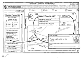
- the map display section 302 presents a map 304 .
- the map 304 depicts the U.S. state of Washington.
- the map 304 includes base contents which constitute raw map data, originating from the raw map source 108 . Such original features include roadways, population centers, natural features (such as lakes, rivers, etc.), and so on.
- the map 304 also includes information that is overlaid on the raw map data. More specifically, as stated above, the MPF 102 ′ operates by linking objects to the map 304 at respective locations in the map 304 . The MPF 102 ′ may notify the user that objects are linked to the map 304 by displaying respective visible items on the map 304 .
- the map 304 includes an exemplary visible item 306 .
- This visible item 306 is a document icon that represents a document-type object that is linked to the map 304 at a selected X-Y location.
- the document-type object includes, as component parts, a visible item 306 and a linked document.
- an object may consist entirely of a visible item (such as an alphanumeric label or icon), having no information linked thereto.
- the map display section 302 also includes a scale-adjustment mechanism 308 .
- the scale-adjustment mechanism 308 allows the user to adjust the scale (e.g., magnification) of the map 304 .
- a focus-adjustment mechanism (not shown) allows the user to adjust the view (e.g., focus) of the map 304 using any type of conventional technique.
- the focus-adjustment mechanism can allow the user to adjust the focus of the map 304 by clicking and dragging on the map 304 .
- the focus-adjustment mechanism can also be implemented using directional arrows (not shown) which allow the user to adjust the focus of the map 304 by activating appropriate directional arrows, e.g., N (north), S (south), E (east), and W (west) arrows.
- appropriate directional arrows e.g., N (north), S (south), E (east), and W (west) arrows.
- An annotation section 310 of the user interface 300 allows the user to attach different types of objects to the map 304 , including, but not limited to: path-type objects; alphanumeric label-type objects; iconic label-type objects; image-type objects; media-type objects (audio, video, etc.); web link-type objects; document-type objects; RSS fed link-type objects; additional map information, and so on.
- the annotation section 310 is implemented as a graphical toolbar that includes separate commands. The separate commands allow the user to link different respective objects to the map 304 . In other words, if a user wishes to link a specific kind of object to the map 304 , the user activates a corresponding command in the annotation section 310 .
- the MPF 102 ′ allows a user to link an object to the map 304 by first uploading the object to the object store 124 .
- the user can initiate this uploading operation by activating an “Upload Objects” command tab 312 .
- the user can then select a desired location on the map 304 by moving a position indicator 314 to the desired location (e.g., by using a mouse device to move the position indicator 314 to the desired location).
- the user can then activate an appropriate command within the annotation section 310 .
- the user can activate a “Doc” command within the annotation section 310 to link this object to the map 304 .
- the MPF 102 ′ then links the selected object to the selected location on the map 304 .
- the visible item 306 represents a document-type object in the map 304 .
- the user may activate the document-type object by clicking on the visible item 306 .
- Other objects that a user can link to the map 304 do not need to be uploaded to the object store 124 in advance of the linking operation.
- the user can add a label-type object to the map 304 by activating an appropriate command in the annotation section 310 .
- Label-type objects optionally do not need to be uploaded to the object store 124 as a precondition to linking these objects to the map 304 .
- a map-creation section 316 allows the user to create a new map. For example, assume that the user wishes to store the annotated map 304 as a new map. To perform this operation, the user can enter a name of the map 304 in a text box in the map-creation section 316 . In the example of FIG. 3 , the user has previously labeled the map 304 as “Wedding Planner.” The user can then activate the “Create New” command in the map-creation section 316 to create a map having the specified title.
- a map summary section 318 of the user interface 300 provides a summary of maps that the user has created.
- the map summary section 318 also provides a summary of the objects associated with each of the maps.
- the map summary section 318 includes two portions, an expanded portion 320 and a collapsed portion 322 .
- the expanded portion 320 provides a detailed summary of the contents of the map entitled “Wedding Planner.”
- the collapsed portion 322 provides a collapsed (or abbreviated) summary of the contents of other maps that the user has created, such as “Example Map 2,” “Example Map 3,” and so on.
- the user interface 300 allows the user to activate one of the maps in the collapsed portion 322 , causing the user interface 300 to summarize the selected map in the expanded portion 320 (instead of the collapsed portion 322 ); in complementary fashion, this operation also causes the map that was previously featured in the expanded portion 320 to now be summarized in the collapsed portion 322 .
- the expanded portion 320 presents two sub-portions of information regarding a map.
- a first sub-portion 324 of the expanded portion 320 presents overview information regarding the map 304 .
- the first sub-portion 324 indicates that the map 304 currently has a status of “Password Protected,” meaning that a person can access the map, providing that he or she inputs a valid password.
- the first sub-portion 324 also provides user interface elements through which the user can enter commands that affect the map 304 . Such user interface elements can include:
- the first sub-portion 324 can include yet additional high-level information pertaining to the map 304 and/or can include other commands that allow the user to interact with the map 304 .
- a second sub-portion 326 of the expanded portion 320 provides an overview of objects that have been added to the map 304 .
- the second sub-portion 326 lists the names of the objects that have been added to the map 304 , as previously defined by the user using the annotation section 310 .
- the user can activate any object that is listed in the second sub-portion 326 , which prompts the user interface 300 to provide additional information regarding the salient characteristics of the identified object. (For instance, FIG. 12 , to be discussed in turn, shows a state of the second sub-portion 326 after the user has clicked on the object entitled “Sally.”)
- FIGS. 3-5 provides further detail regarding the user interface 300 in the context of a particular use scenario.
- the explanation of FIGS. 3-5 will forego the generic use of the term “user” in favor of the more specific terms “author-user” and “end-user.”
- An author-user is a user who creates some feature of the map 304 , such as by linking an object to the map 304 .
- An end-user is a user who utilizes the map 304 , but does not modify it. Of course, it will be appreciated that an end-user can also be an author-user.
- FIGS. 3-5 is entirely exemplary; Section B (below) will describe many more applications.
- an author-user has created an annotated map 304 for use in coordinating wedding-related activities. That is, the author-user intends the map 304 to serve as a hub of information for access by any end-user who will attend the wedding. As such, the author-user may create the map 304 as a password-protected map and then notify the guests of a password that can be used to gain access to the map 304 .
- the author-user sets the map 304 up such that, when first activated, the map 304 shows a depiction of the entire state of the Washington. Since many of the guests are expected to travel to Washington from other parts of the country, the author-user may append a document-type object to the map 304 that provides directions to the wedding site. More specifically, as the wedding is being held in Spokane, the author-user can attach the document-type object to the map 304 in proximity to the city of Spokane. The user may access the directions by clicking on a visual item 306 that represents the document-type object.
- the expanded section 320 of the user interface 300 reveals that the map 304 includes many associated objects, not just the document-type object represented by visual item 306 .
- the author-user has set up the map, using the ZC module 126 , so that certain objects are displayable at certain respective ranges of zoom levels.
- the only object that is displayable at the state-wide level is the document-type object, associated with the visible item 306 .
- the ability to selectively display objects at predetermined zoom levels is desirable, as it allows the author-user to avoid cluttering the map 304 with detail that may not be useful at certain zoom levels.
- the user interface 300 can allow the author-user to custom-define the range of displayable zoom levels in a manner set forth below in greater detail.
- FIG. 4 shows a street-level depiction of the city of Spokane. Note that the expanded depiction of the map 304 in FIG. 4 includes various visible items that were not presented in the state-level depiction shown in FIG. 3 . These visual items represent corresponding objects that have been attached to the map 304 by the author-user.
- the exemplary visual items and associated objects are summarized as follows.
- FIG. 5 shows an example of the user interface 300 after the end-user activates one of the objects shown in FIG. 4 .
- the end-user has clicked on the visual item 414 , which is associated with an image-type object.
- This user action prompts the user interface 300 to present an overlaid window 502 that shows a picture of the bride, Sally.
- the MPF 102 ′ can be applied to a myriad of other applications.
- composition of the system 100 and its associated user interface presentation 300 provides additional details regarding individual tools in the collection of annotation tools 110 .
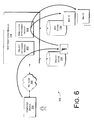
- FIGS. 6-10 provide further details regarding the annotation module 122 .
- FIG. 6 shows a first version of the annotation module 122 , where the annotation module 122 is configured to allow a user to manually upload objects (document-type objects, image-type objects, media-type objects, etc.) to the object store 124 , and then link the objects to a map.
- the manual mode of annotation also allows the user to link other objects (icon-type objects, alphanumeric-type objects, path-type objects, link-type objects, etc.) that do not need to be uploaded to the object store 124 .
- the first version of the annotation module 122 includes an object uploading module 602 .
- the purpose of the object uploading module 602 is to upload a user-selected object to the object store 124 .
- the annotation module 122 also includes an annotation attachment module 604 .
- the purpose of the annotation attachment module 604 is to link an uploaded object to a map that is stored in the map store 120 .
- a single object stored in the object store 124 can be linked to two or more maps, such as Map A and Map B.
- Map A and Map B maps
- FIGS. 7-9 show a sequence of presentations provided by the user interface 300 that illustrate the first version of the annotation module 122 .
- the user uploads an image-type object in the form of the digital photograph to the object store 124 using the object uploading module 602 , and then attaches the image-type object in the object store 124 to the map 304 using the annotation attachment module 604 .
- the user is an author-type user, referred to for brevity as just a “user.”
- the user can activate the object uploading module 602 by clicking on the tab 312 .
- the object-upload user interface 702 includes two portions.
- a first portion 704 allows the user to browse through a collection of objects and select a desired object for uploading.
- the browsing operation is initiated by activating a Browse command.
- the user in the specific scenario shown in FIG. 7 has selected an image-type object stored on the client device 104 as “C:desktop/picture_ 107 .”
- the user can initiate the actual uploading process by activating an “Upload Now” command.
- This action prompts the object uploading module 602 to present a user prompt 706 .
- the user prompt 706 asks the user to provide a label for the uploaded image-type object. This label defines the title of the image-type object in the object store 124 .
- a second portion 708 presents a list of objects stored in the object store 124 .
- the user has selected the caption “Picture of Sally” in response to the user prompt 706 .
- the listing in the second portion 708 shows, as the last entry, the caption “Picture of Sally.”
- Each entry in the listing also includes supplemental icons. These icons activate commands when the user clicks on the icons.
- a first command allows the user to view the associated object.
- a second command allows the user to rename the object.
- a third command allows the user to delete the object.
- this presentation of the user interface 300 allows the user to activate the annotation attachment module 604 so as to attach the uploaded image-type object to the map 304 .
- the user initiates this procedure by first moving the position indicator 312 to a location in the map 304 at which the user wishes to attach the image-type object.
- the user can perform this task by moving the position indicator 312 using a mouse-type device in conventional fashion.
- the image annotation portion 802 allows the user to display a list 804 of image-type objects that can be attached to the map 304 (wherein these image-type objects have been previously uploaded by the user according to the procedure described above with reference to FIG. 7 ).
- the annotation attachment module 604 In response to clicking the “Add Picture” command, the annotation attachment module 604 generates a user prompt 806 .
- the user prompt 806 instructs the user to select a name for the image-type object. This defines the name that will appear in the expanded summary sub-portion 326 in the left-hand part of the user interface 300 , which lists all of the objects that have been attached to this particular map, entitled “Wedding Planner.” In this case, note that although the photograph of Sally is stored in the object store 124 as “Picture of Sally,” the user has labeled the image-type object for purposes of the expanded summary sub-portion 326 as simply “Sally.”
- the user interface 300 allows the user to add other objects (alphanumeric-type objects, iconic-type objects, etc.) to the map 304 without previously uploading these objects to the object store 124 .
- the annotation procedure for other types of objects is similar to the operation outlined above for the image-type object. That is, in general, the user first selects a location in the map 304 by moving the position indicator 312 to a desired position in the map 304 . The user next activates an appropriate command in the annotation section 310 , corresponding to the type of object which the user intends to attach to the map 304 . The annotation attachment module 604 then asks the user to supply a label (e.g. a title) for the object.
- a label e.g. a title
- FIG. 9 shows a special procedure for annotating the map 304 with a path-type object, such as the path-type object 408 that traces a course from the wedding site to the reception site.
- a path-type object is characterized by multiple legs.
- the annotation module 122 creates the path-type object by allowing the user to successively specify endpoints of the path's legs, defined by a collection of path nodes.
- the user initiates the path-creation process by activating the “Create Path” command in the annotation section 310 .
- This prompts the annotation module 122 to provide a path creation user interface 902 .
- the path creation user interface 902 includes a single “+” icon, representing an invitation for the user to select a starting node of the path-type object.
- the user moves the position indicator 312 to define the starting node of the path-type object and then clicks on the first (and only) “+” icon in the path creation user interface 902 .
- This action prompts the annotation module 122 to label the initial path node in the map 304 with the numeral “1,” and then add a second “+” icon below the first “+” icon in the path creation user interface 902 .
- the second “+” icon serves as an invitation for the user to select a second path node in the path-type object, representing the endpoint of a first leg of the path-type object.
- the user performs this function in the same manner described above for the first path node, namely by moving the position indicator 312 to a desired location and then clicking on the second “+” icon.
- the annotation module 122 can draw this part of the path-type object using a visibly discernable line segment. In FIG. 9 , the path-type object 408 traces a route using a dotted line.
- the above-described procedure can be repeated as many times as required until the user has defined the complete course of the path-type object.
- the user is in process of adding a fourth path node to the map 304 , having positioned the position indicator 312 to a desired location of the fourth path node. It remains to simply click on a fourth “+” icon 904 to formally add the fourth path node to the map 304 .
- the path creation user interface 902 may include additional icons associated with other path-related operations. The user may invoke these operations by clicking on these icons. More specifically, the icons having the up and down arrows ( ⁇ , ⁇ ) allow the user to adjust the order of path nodes that define the path-type object, that is, by respectively moving a selected path node ahead in the sequence of path nodes, or behind in the sequence of path nodes. This operation therefore redefines the shape of the path-type object.
- An “X” icon allows the user to delete a path node in the path-type object.
- the system 100 does not require the user to manually specify position information. Rather, the system 100 can automatically extract position information based on, for example, GPS data. For instance, assume that the user takes several pictures while on a vacation and that the camera that is used is equipped with a GPS-registering mechanism. In this case, the GPS data and time data (indicating the order in which the photographs were taken) can be extracted to automatically reconstruct the user's route while on vacation.
- the system 100 can display the path in the same manner described above, e.g., as a series of line segments. Moreover, the system 100 can automatically annotate the path with the pictures that were taken while on vacation.
- this figure shows further details of a second version of the annotation module 122 designed to automatically (instead of manually) add objects to a map in the map store 120 . That is, this version of the annotation module 122 is configured to automatically cull objects from at least one data source 1002 that meet some specified criterion (or plural criteria), and then automatically add the culled objects to the map 304 .
- the annotation module 122 includes an annotation set-up module 1004 .
- the purpose of this module 1004 is to collect information from the user which will govern the automated operation of the annotation module 122 .
- a first piece of information allows the user to optionally specify at least one data source 1002 that is to be mined for objects.
- the user may select an RSS news-related feed data source as the data source 1002 .
- Such a data source 1002 can provide news stories structured in the XML format.
- the user can select any other type of data source, expressed in any kind of format.
- a second piece of information that the set-up module 1004 can collect specifies at least one criterion that will define whether an object in the data source 1002 matches the user's interest, thus indicating that the matching object should be added to the map 304 .
- This input information can take various forms.
- the user may specify a key term that defines a subject of interest. For example, suppose that the user is interested in tracking news stories about the threat of bird flu. The user can first select a data source 1002 that is likely to feature news about the topic of bird flu. (Or the user can select plural data sources, such as a family of databases that feature news related to medical topics). Then the user may specify a key term of “bird flu.” Assuming that the user is primarily interested in the incidence of bird flu in North America, the user may also enter the search term of “North America.”
- the annotation module 122 includes an automatic-annotation extraction and annotation module 1006 , shortened to “auto-extraction module” for brevity.
- This module 1006 extracts objects from the data source 1002 and adds the extracted objects to the map 304 at appropriate positions. More specifically, this module 1006 can operate by periodically scanning the data source 1002 to determine if the data source 1002 includes any content that matches the selection criterion (or criteria) input by the user. This investigative function can be performed by determining whether any news stories in the data source 1002 includes alphanumeric content that matches a key term specified by the user. In other cases, the auto-extraction module 1006 can apply other kinds of rules and heuristic considerations in determining whether objects in the data source 1002 match the user's interests.
- the auto-extraction module 1108 next links the object to the map 304 at an appropriate position. To perform this function, the auto-extraction module 1006 determines where to place the object.
- One way of performing this task is to examine a news story to determine if it contains any reference to a geographical location, such as by including the name of a country, province, state, city, region, and so forth.
- the auto-extraction module 1108 can apply various rules and heuristic considerations to identify the location-based content of a news story. For example, the byline of the news story may or may not pertain to the actual geographic location being discussed in the story. A rule can thereby be applied to appropriately discount the occurrence of a geographic term in the byline of a news story.
- the auto-extraction module 1006 can add points to a relevance-related score if a geographic entry appears repeated times in the body of a new story.
- a news story may prominently identify two or more locations, such as in the case of a story that describes tensions between two countries.
- the auto-extraction module 1008 can optionally link the story to two different locations on the map 304 .
- the auto-extraction module 1006 can link the object to the map 304 at an appropriate location.
- the auto-extraction module 1006 can also assess the relevance of an object that matches the selection criterion.
- the auto-extraction module 1006 can assess relevance in any manner, such as by determining whether the object (such as a particular news story) is popular, as reflected by the fact that a large number of people have accessed it. To be more explicit, the inference being made here is that a popular object is also a relevant object.
- the auto-extraction module 1006 can infer that an object is relevant based on how strongly it correlates with a specified search term (e.g., based on the number of times that the search term appears in a news story), and so on. Still further mechanisms for assessing relevance can be used, or any combination of mechanisms can be used.
- the auto-extraction module 1008 can then present an object in the map 304 in a manner that is related to the assessed relevance (e.g., relative rank) of the object. For instance, the auto-extraction module 1006 (in conjunction with the ZC module 126 ) can display a highly relevant object so that it is visible over a wider range of zoom levels compared to a less relevant document. In another case, the auto-extraction module 1006 (in conjunction with the ZC module 126 ) can display each object so that it appears at the most appropriate zoom level (or zoom levels), but the auto-extraction module 1006 (in conjunction with the ZC module 126 ) may otherwise assign each object the same range of zoom levels.
- the assessed relevance e.g., relative rank
- a story about a federal tax program may be displayed over 5 zoom levels in which the entire country is generally in focus in the map 304 .
- a story about an ordinance that may affect a local community may be displayed over 5 zoom levels in which the community is generally in focus in the map 304 .
- the auto-extraction module 1006 (in conjunction with the ZC module 126 ) can combine the features of the first two cases, such that the auto-extraction module 1006 (in conjunction with the ZC module 126 ) determines, based on relevance, both: (a) an appropriate range of zoom levels; and (b) a zoom level at which the range is centered on. Still other strategies can be used to govern the display of objects based on their respective relevance.
- the annotation module 122 can use other techniques (rather than the selection of zoom levels) to emphasize (or deemphasize) certain objects. For example, the annotation module 122 can proportionally increase the size of visual items on the map 304 to suit the relative importance of the corresponding objects, change the level of transparency or color of the visual items to convey relevance, add descriptive icons or other information to convey relevance, and so on.
- the user can apply the above-described procedure to examine an auction-related database, such as a database provided by EBay, Inc., of San Jose, Calif. That is, for example, the user can identify the EBay database as a data source in conjunction with a keyword “Rolex” as a selection criterion.
- the procedure can examine the database, identify all auctions that involve the sale of a Rolex watch, identify the regional affiliations of these auctions (e.g., which may correspond to the locations of the sellers), and then automatically annotate a map to show the identified locations.
- the annotation module 122 can automatically annotate a map based on other auto-annotation paradigms.
- the annotation module 122 can employ a “spider” program to troll the web to identify websites that provide content having a certain character, such as, in one case, websites that are dedicated to providing news content.
- the annotation module 122 can then examine the nature of each website to determine whether it has a regional affiliation. For example, an RSS news feed associated with the Miami Herald includes content that emphasizes news that is particularly pertinent to southern Florida. Based on this determination, the annotation module 122 can annotate a map with links associated with the different websites. The end-user may click on any link as a convenient means of discovering content that is pertinent to a particular region.
- the annotation module 122 can identify websites that feature information regarding a recreational activity, such as surfing, and then place these websites on a map based on their regional affiliations (if, in fact, the websites exhibit regional affiliations).
- the user can initiate the geo-location of a news story on a more fine-grained story-based level. For example, the user can click on an individual news story, causing the annotation module 122 to perform location-based analysis on this specific news story. If the news story has a regional affiliation, the system 100 can place the news story on a map at an appropriate position (e.g., by displaying an icon or a link to the story at the appropriate position).
- FIGS. 11 and 12 show further details regarding the zoom control (ZC) module 126 .
- the purpose of the ZC module 126 is to allow the user to manually select a range of zoom levels over which an object is made visible. This feature is useful so as to not unduly clutter the map 304 with information that may not be relevant to the user.
- the annotation module 122 can work in conjunction with the ZC module 126 to automatically select a range of zoom levels when automatically adding an object to the map 304 .
- the purpose of the ZC module 126 described in this subsection is to allow the user to manually select the zoom level range at which an object is made visible.
- the ZC module 126 accepts zoom selections from the user, including a minimum zoom level and a maximum zoom level. These zoom levels define the bounds of a range of zoom levels over which an object will be made visible in the map 304 . To be more specific, if an end-user selects a zoom level that lies outside this range, the object will not be displayed (or at least will not be displayed in its complete form). If the user selects a zoom level that lies within the range, the object will be displayed. As explained above, an object is displayed by showing a visible item on the map 304 that is associated with the object.
- FIG. 12 shows how the user interface presentation 300 can be used to implement UI-related aspects of the ZC module 126 .
- the user has clicked on the title of the object “Sally” in the expanded summary sub-portion 326 of the user interface 300 .
- this object represents an image-type object (e.g., a digital photograph) of a person named Sally.
- this object is represented by a visual item 414 (e.g., a camera icon) that appears in the map 304 .
- Activating the object name “Sally” prompts the user interface 300 to display salient characteristics of this object in a featured panel 1202 .
- the featured panel 1202 includes various icons that allow the user to enter various respective commands (by clicking on the icons).
- One command allows the user to select a minimum zoom level.
- Another command allows the user to select a maximum zoom level.
- Another command allows the user to relocate the featured object to another location in the map 304 .
- Another command allows the user to rename the object.
- Another command allows the user to delete the object.
- the user has selected a minimum zoom level of “2” and a maximum zoom level of “4.” This means that the map 304 will display the visual item 414 (corresponding to a camera icon) for zoom levels of 2, 3, and 4, but not any other zoom level outside this range.
- the ZC module 126 can control the selective display of objects based on both the minimum zoom level and the maximum zoom level. In another case, the ZC module 126 can control the selective display of objects based on either the minimum zoom level or the maximum zoom level. For example, if only the minimum zoom level is specified, the ZC module 126 can make the object visible for any requested zoom levels that equal or exceed the minimum zoom level.
- FIG. 13 provides further details regarding the map creation and publication (CP) module 118 . More specifically, the following explanation focuses primarily on the publication component of the CP module 118 . As stated above, the purpose of this module 118 (as it pertains to publication) is to retain a created map in a form that can be optionally accessed by others.
- CP map creation and publication
- the CP module 118 publishes a map by prompting the user to select one of a group of possible security options.
- a first security option allows the user to publish the map 304 without restriction, meaning that anyone in the general public can access the map 304 .
- a second security option allows the user to publish the map 304 with a password, enabling only those who know the password to access the map.
- a third option allows only the author to access the map 304 .
- the CP module 118 can give the user the option of assigning different security options to different actions that may be performed with respect to the map 304 .
- the user can select a security option that permits any person to access the map 304 without restriction.
- the user can also select a security option that allows only a select group of users to modify the map 304 . This selectivity can be achieved by requiring users to enter a valid password as a precondition to modifying the map 304 .
- the CP module 118 can optionally allow the user to attach security options on a more fine-grained level, such as by attaching access constraints to individual objects (as opposed to the map as a whole). For example, if a certain photograph is regarded as highly confidential, then the CP module 118 can prevent non-authorized users from accessing this photograph, even though the map as a whole may be registered as available for public consumption. In this case, the CP module 118 defines an object-level security constraint which overrides the map-level security policy.
- the CP module 118 can register a map as private as a default rule. The user can then be allowed to remove this constraint by making the map open to the general public or by making the map password protected.
- the CP module 118 can allow a first user to send a map to other users.
- the first user can perform this task by Emailing a link to the map to one or more other users, or by sending the link via an IM message, or by posting the link to a website, and so on.
- the CP module 118 can allow users to share maps through blogs, etc. These sharing provisions allow a social network to be formed around a map that is of common interest to a group of users.
- FIG. 14 shows further details regarding the map search module 128 .
- the general purpose of the search module 128 is to perform a search that relies on one or more annotated maps.
- the search module 128 can utilize the maps in different ways, some of which are identified below.
- this module 128 allows the user to perform a search for content within an individual map.
- the map search module 128 can allow the user to define a bounding box 1402 .
- the bounding box 1402 defines a region within the map 304 that is demarcated by the boundaries of the box 1402 .
- the user can draw the bounding box 1402 on the map 304 in any manner, such as by performing a click and drag operation using a mouse device.
- the map search module 128 can allow the user to define a bounding region of arbitrary shape, e.g., by drawing the boundary of this region in free-form fashion on the map 304 using the mouse device.)
- the map search module 128 can also allow the user to enter at least one selection criterion, such as a key term. In operation, the map search module 128 can then investigate the objects that may appear within the defined bounding box 1402 to determine whether these objects satisfy the selection criterion. If they do, the map search module 128 can convey this fact to the user in some manner, such as by presenting a list of the matching objects, or by highlighting the matching items on the map 304 itself.
- the user may enter search criteria which indicates the make of the car which she desires to purchase, as well a maximum amount of money she is willing to pay.
- the user may then draw the bounding box 1402 on the map 304 which identifies the desired part of Portland.
- the map search module 128 responds to these selections by determining whether there are any used cars in the specified region that meet the user's search constraints. The search module 128 can then notify the user of the results of the search.
- the user's selection criterion can identify a particular type of object that the user is looking for, such as an image-type object.
- the user in the above car-shopping scenario can optionally restrict the results to only those annotations that include a picture of a car being sold.
- the user may enter a selection criterion that specifies the type of object without specifying an alphanumeric search term, and so on.
- the user can search an entire map for desired content, that is, without specifying a bounding box.
- the user's selection of a bounding box 1402 is used in the actual formulation of a search term, and this search term is then applied to one or more data sources 1404 to extract relevant objects.
- this search term is then applied to one or more data sources 1404 to extract relevant objects.
- the user can first optionally select one or more relevant data sources 1404 that can be mined for the news stories.
- the user can then draw a bounding box 1402 on the map of Oregon to identify the eastern part of Oregon as a locus of interest.
- the map search module 128 can search the data source(s) 1404 for any stories that pertain to eastern Oregon.
- the search module 128 can perform this task by first automatically identifying search terms that are relevant to eastern Oregon, such as by automatically extracting the names of the cities in this region.
- the search module 128 can identify search terms using a predetermined lookup table, or by analyzing the contents of the selected part of the map 304 itself. The search module 128 then automatically determines whether any news stories contain the identified geographical search terms.
- the map search module 128 can present the outcome of its search in the manner specified above, e.g., by presenting a list of relevant items.
- the search module 128 can allow the user to search through a database of maps created by one or more users. For example, fishermen may create individual maps to identify their favorite fishing locations within a particular state. Taken together, these maps represent a valuable source of information for anyone who is interested in catching fish of a particular type. For example, the user can enter the type of fish which she wishes to catch, along with the general region of interest.
- the search module 128 can mine the database of maps to provide site recommendations to the user. In a particular version of this approach, the user can view and/or search maps produced by specified authoring-users, e.g., by inputting the passwords or other identifying information associated with these users.
- Still other search strategies can utilize annotated maps.
- FIGS. 15-21 Exemplary Method of Operation
- FIGS. 15-21 describe the operation of the system 100 in flowchart form. To facilitate discussion, certain operations are described as constituting distinct steps performed in a certain order. Such implementations are exemplary and non-limiting. Certain steps described in these flowcharts can be grouped together and performed in a single operation, and certain steps can be performed in an order that differs from the order shown in the flowcharts. As the functions described in these flowcharts have already been explained in prior sections, Section B will serve mainly as a review of those functions.
- FIG. 15 shows an exemplary procedure 1500 for manually linking an object to a map.
- step 1502 the system 100 optionally receives the user's instruction to upload an object, and then receives the actual uploaded object itself for storage in the object store 124 .
- step 1504 the system 100 receives the user's indication of a location at which the object will be placed in the map.
- step 1506 the system 100 receives the user's instruction to link the object to the selected location in the map.
- step 1508 the system 100 receives the user's label assigned to the object to be linked to the map. This label serves as a reference title of the object.
- step 1510 the system 100 links the object to the specified location in the map.
- the system 100 can link other objects to the map without first uploading these objects to the object store 124 .
- FIG. 16 sets forth an exemplary procedure for allowing a user to create a path-type object.
- a path-type object is defined by multiple path nodes, where the path nodes define associated path segments.
- step 1602 the system receives the user's selection of a path node.
- This operation can be performed in the manner specified in the previous section, that is, by moving the position indicator 312 to an appropriate location within the map and then activating an add-node command (e.g., by activating a “+” icon).
- Steps 1602 and 1604 taken together, convey that the user can repeat the above-described operation a number of times until the path-type object is fully specified.
- step 1606 the system 100 allows the user to define the title of the path-type object, which facilitates reference to the path-type object.
- step 1608 the system 100 formally links the path-type object to the map as a certain type of annotated object.
- FIG. 17 shows an exemplary procedure 1700 for automatically selecting objects from a data source (or plural data sources) and linking the objects to a map.
- the system 100 optionally receives the user's selection of one or more data sources to mine for objects.
- the procedure can perform a more open-ended search, such as by using a spider program to automatically identify a relevant data source (or sources).
- the system 100 receives the user's specification of at least one selection criterion.
- a selection criterion defines conditions that should be met before an object is deemed to satisfy the interests of the user, enabling the object to be added to the map.
- step 1706 the system 100 automatically annotates the map based on the selections made in steps 1702 and 1704 .
- step 1708 the system 100 accesses the selected data source(s).
- step 1710 the system 100 determines whether there are any new objects in the data source to add to the map.
- the system 100 performs this function by determining whether any new objects satisfy the selection criterion defined by the user.
- the system 100 can optionally assess the relevance of any matching objects based on any relevance-determination paradigm or combination of paradigms.
- the system 100 can add matching objects to the map.
- the system 1714 can tailor the display of the objects (or visual items that correspond to the objects) based on the respective relevancies of the objects. In one case, this allows objects that are deemed as relatively important to be displayed more prominently in the map compared to objects that are considered less important.
- FIG. 18 shows a procedure 1800 that sets forth a method for receiving the user's manual selection of a range of zoom levels.
- step 1802 the user specifies a minimum zoom level.
- step 1804 the user specifies a maximum zoom level.
- the system 100 can automatically define a zoom range based on an assessment of the relevance of an object in question.
- step 1808 the system 100 stores the zoom information, such as the minimum and maximum zoom levels.
- FIG. 19 shows a procedure 1900 that sets forth a method for selectively presenting objects based on selected minimum and/or maximum zoom levels.
- step 1902 the system 100 receives the user's request to present a map at a selected zoom level.
- step 1904 the system 100 determines whether a particular object under consideration is visible at the selected zoom level. This is ascertained by determining whether the selected zoom level lies within a visible zoom range defined for this particular object. This operation is repeated for all objects linked to a map.
- step 1906 the system 100 displays an object based on the above-defined criterion.
- step 1908 the system 100 does not display the object because it does not satisfy the above-defined criterion.
- FIG. 20 illustrated a procedure 2000 for publishing a map.
- step 2002 the system 1000 receives the user's request to publish a map.
- This request can be an implicit instruction based on the context of the user's interaction with the system or an express instruction.
- step 2004 the system 100 receives the user's selection of a security-related option, e.g., indicating whether the user wishes the map to be accessible by everyone without restriction, accessible to a group of users that know a password used to access the map, or accessible to no one but the author of the map.
- a security-related option e.g., indicating whether the user wishes the map to be accessible by everyone without restriction, accessible to a group of users that know a password used to access the map, or accessible to no one but the author of the map.
- step 2006 the system 100 optionally allows the user to later modify the security option selected in step 2004 .
- the user may originally established a non-public map or a password-restricted map, but subsequently desires to make map available to a wider group of users.
- step 2008 the system 100 potentially restricts access to the map based on the selected security option.
- FIG. 21 shows a procedure for performing a search based on one or more previously created maps.
- step 2102 the system 100 receives the user's selection of a search term.
- This operation may involve receiving the user's selection of a region in a single map defined by a bounding box, in optional combination with one or more search terms.
- This operation may also (or alternatively) involve setting up a search of multiple maps, to determine whether the maps contain sought-after information.
- map-based searching paradigms are possible; these paradigms may prompt the user to supply different kinds of input selections.
- step 2104 the system 100 searches one or more maps based on the input selections made in step 2102 .
- step 2106 the system 100 outputs results of the search to the user.
- the system 100 can include multiple applications 112 that make use of the annotation tools 110 .
- the following explanation provides several examples of the applications 112 .
- the list of applications provided below is representative, not exhaustive.
- the system 100 can allow advertisers to link advertising-related objects to a user's maps. In doing so, the advertiser can use the zoom control (ZC) module 126 to define the zoom levels at which the advertising-related objects are made visible.
- ZC zoom control
- the selection of a visibility range for a particular object may depend on the characteristics of the product or service that is being advertised. For example, if the system 100 determines that an item being advertised has nation-wide appeal, then the system 100 can display a corresponding advertising-related object over a wide range of zoom levels, where such range encompasses nation-wide zoom levels. However, if the system 100 determines that the item being advertised has only local appeal, then the system 100 can display the associated advertising-related object over a more limited range of zoom levels, wherein such range encompasses locale-specific zoom levels.
- the system 100 can allow an advertiser to increase the exposure of an advertising-related object by paying additional advertising-related fees.
- the system 100 can charge a first advertising fee for the presentation of an object over 5 zoom levels, a second (larger) advertising fee for the presentation of an object over 10 zoom levels, and so on.
- the system 100 can adjust an initially selected zoom range based on empirical data that reflects actual user consumption of an advertisement. For example, if the system 100 determines that it is more prevalent for users to click on an advertisement when presented at a state-wide zoom level rather than a local zoom level, the system 100 can more sharply focus the presentation of the advertisement to a range of state-wide zoom levels, rather than local zoom levels.
- the end-user can activate a particular depiction of a map by selecting a desired view and scale.
- the user may receive one or more advertisements that the system 100 deems to be relevant to this particular map depiction.
- the advertisements can be linked to particular map content in different ways.
- the system 100 can govern the selection of advertisements based on the map coordinates of one or more features being shown in the selected map (such as the map coordinates of a particular city that is being shown).
- the triggering criteria can also take into account scale, as noted above, meaning that a map display that encompasses Spokane on a state-wide level may prompt the display of a first series of advertisements, while a map display that encompasses Spokane on a street level may prompts the presentation of a second series of advertisements.
- the system 100 can provide an Email notification to a message-sending user when the message-sending user sends an Email to a target user who happens to be “away from the office” at the time.
- the Email notification can display a map which shows the current location of the target user. For example, the to target user may be visiting different cities on different days of a trip.
- the target user can create a map which provides a path-type object which plots the target user's planned trip route.
- the target user can then link this map the target user's out-of-office Email notification.
- the map enables the message-sending user to determine where the target user is located when the message-sending user sends an Email to the target user.
- Such a map can be annotated with objects which provide contact information, such as the respective telephone numbers of the hotels at which the target user will be staying over the course of the trip.
- the user can carry a GPS mechanism (or other position-determination mechanism) while on the trip.
- the GPS mechanism can forward location information to the map which indicates the current position of the user.
- the map can plot the path of the user based on the actual movements of the user.
- the system 100 can allow the user to link together several maps corresponding to different respective instances in time.
- the system 100 can allow the user to annotate each map in the manner defined above based on a particular theme of an application. For instance, in one such application, the user can generate a series of maps which show the spread of pollution in a certain region over time, with each map representing a depiction of the area at a particular point in time. Each map can be annotated with objects which represent pollution sources at a particular point in time, etc.
- the system 100 can provide a map that is accessible to a defined group of users (via a password protection mechanism) or to any individual without restriction.
- the system 100 can optionally allow the users to modify the map, such as by adding objects to the map, including photographs, documents, audio resources, etc.
- the map is effectively shared by plural users. And hence, the map at any point in time may represent the collaborative contribution of several users.
- a hosting author can create a master map of the park.
- the master map can show the general layout of the park, various attractions offered by the park, and so on. Users can individually annotate this master map by adding objects, such as photographs, paths, textual descriptions, and so forth.
- the users can create personal maps and add links on the master map through which these personal maps can be accessed.
- Each of these personal maps can itself be annotated with various objects, such as photographs, paths, textual descriptions, and so forth. For example, assume that there are various idiosyncratic ways to climb to the top of a mountain in the park.
- a user can prepare a personal map that includes a path object that shows one route to the top of the mountain, along with pictures taken along the way, textual comments regarding obstacles that are likely to be encountered, and so on.
- the user can add this personal map to the master map by adding a link within the master map at an appropriate location, such as at the start of the route or at another location which best characterizes the route.
- the user can define whether or not this personal map should be made public using the tools described above. If the personal map is made public, other users will be able to access it via the master map.
- the system 100 can assess the relevance of objects created by different users.
- One way to perform this task is to determine how popular a particular object has proven to be, e.g., based on how many times users have clicked on the object (or otherwise activated the object) in the master map.
- the system 100 can select a zoom range for each object based on its relevance. For example, if a hiker has created a personal map which is popular among other hikers, then the system 100 can present a link to this map on the master map over a relatively wide range of zoom levels of the master map.
Landscapes
- Engineering & Computer Science (AREA)
- Theoretical Computer Science (AREA)
- Databases & Information Systems (AREA)
- General Physics & Mathematics (AREA)
- Physics & Mathematics (AREA)
- General Engineering & Computer Science (AREA)
- Data Mining & Analysis (AREA)
- Remote Sensing (AREA)
- Health & Medical Sciences (AREA)
- Artificial Intelligence (AREA)
- Audiology, Speech & Language Pathology (AREA)
- Computational Linguistics (AREA)
- General Health & Medical Sciences (AREA)
- User Interface Of Digital Computer (AREA)
- Information Retrieval, Db Structures And Fs Structures Therefor (AREA)
Abstract
Description
-
- A first user interface element allows the user to set a password. The password allows the
map 304 to be accessed by a group of users that happen to know the password. - A second user interface element allows the user to set a default depiction of the
map 304. The default depiction governs the view and scale of themap 304 that is presented to the user when the user initially activates themap 304. The user may set the default depiction of a map by adjusting the scale and view of the map as desired, and then activating the illustrated “Set View” command. - A third user interface element allows the user to rename the map 304 (e.g., by changing the name “Wedding Planner” to some other name).
- A fourth user interface element allows the user to remove a previously selected password for the
map 304. - A fifth user interface element allows the user to instruct the
MPF 102′ to un-publish the map 304 (thereby revoking a previous instruction to publish the map). In one exemplary implementation, theMPF 102′, by default, maintains a created map as a private map, accessible only to the author of the map.
- A first user interface element allows the user to set a password. The password allows the
-
- A first
visual item 402 is an icon-type object that represents the location of a site where the wedding will be held. This object (i.e., a house icon) can be added by activating an icon command in theannotation section 310. The icon-type object is accompanied by an alphanumeric-type object (a label that reads “The Wedding Site”) which can be added by activating an alphanumeric labeling command in theannotation section 310. - A second
visual item 404 is a media-type icon that represents a media-type object, in this case an audio file. The media-type object may present snippets of songs that the bride and groom have selected to be played at the wedding ceremony. This media-type object (the audio file) can be added by activating a media command in theannotation section 310. - A third
visual item 406 is another icon-type object that represents the location at which the reception is being held. The icon-type object is accompanied by an alphanumeric-type object (a label that reads “The Reception”). - A fourth
visual item 408 represents a path-type object, describing a route from the wedding site to the reception site. The path-type object is constructed as several path segments, defined by path nodes (1) through (5). The path-type object can be added by activating a path creation command in theannotation section 310. - A fifth
visual item 410 represents a link-type object. In this case, the link-type object directs the end-user to a bridal registry website. In other words, an end-user can access this website by clicking on the hypertext link provided by in thevisual item 410. The link-type object can be added by activating a web link command in theannotation section 310. Thevisual item 410 associated with the link-type object is accompanied by another icon-type object, which may represent the location of the house at which the bride's parents reside. - A sixth
visual item 412 represents another icon-type object, this time representing a location of a motel at which many guests are invited to stay. The author-user can add this icon-type object by activating the icon command in theannotation section 310. - A seventh
visual item 414 represents an image-type object that can be revealed by clicking on thevisual item 414. The image-type object can be added by activating an image command in theannotation section 310. Thevisual item 414 is accompanied by an alphanumeric-type object (the label “Sally”) that can be input via the alphanumeric label command in theannotation section 310. The label describes the image-type object. - Finally, an eighth visual item 416 represents a document-type object that can be accessed by clicking on the item 416. The document-type object may provide a menu for a local restaurant.
- A first
-
- Fishermen can use the
system 100 to create maps annotated with data collected from several different sources, such as tide-related information sources, weather-related information sources, and so on. - Travel agencies can use the
system 100 to create maps for clients. The maps may include photos of interesting sites, menus of recommended restaurants, fare-based information, travel advisory information, recommended walking tour, and so forth. Individual travelers can also create their own custom annotated maps. - The
system 100 can be used to create genealogical-related maps. These maps may trace the migration of family members over time. Such a map can be linked with photographs of family members, interesting family-related documents (such as birth certificates, wills, etc.), and so forth. - The
system 100 allows users to log the locations of certain sales discounts, such as the locations of gas stations offering relatively inexpensive gas, the locations of food stores offering specials on certain items, and so forth. - The
system 100 can be used by real estate agents to map the locations of properties for sale, along with salient information regarding the properties. - The
system 100 can be used by event organizers (such as conference organizers) to provide salient information regarding an event, such as the location of motels and restaurants near the event, a schedule for the event, and so forth. - The
system 100 can be used by national and international business chains to map the locations of their outlets. The maps can also provide photographs of merchandise offered by these sites, details of discounts being offered, and so forth.
- Fishermen can use the
Claims (17)
Priority Applications (4)
| Application Number | Priority Date | Filing Date | Title |
|---|---|---|---|
| US11/465,731 US7945852B1 (en) | 2006-05-19 | 2006-08-18 | Strategies for annotating digital maps |
| US13/108,699 US8904275B2 (en) | 2006-05-19 | 2011-05-16 | Strategies for annotating digital maps |
| US14/091,987 US20140089771A1 (en) | 2006-05-19 | 2013-11-27 | Strategies for Annotating Digital Maps |
| US14/092,053 US20140089776A1 (en) | 2006-05-19 | 2013-11-27 | Strategies for Annotating Digital Maps |
Applications Claiming Priority (2)
| Application Number | Priority Date | Filing Date | Title |
|---|---|---|---|
| US80178406P | 2006-05-19 | 2006-05-19 | |
| US11/465,731 US7945852B1 (en) | 2006-05-19 | 2006-08-18 | Strategies for annotating digital maps |
Related Child Applications (1)
| Application Number | Title | Priority Date | Filing Date |
|---|---|---|---|
| US13/108,699 Continuation US8904275B2 (en) | 2006-05-19 | 2011-05-16 | Strategies for annotating digital maps |
Publications (1)
| Publication Number | Publication Date |
|---|---|
| US7945852B1 true US7945852B1 (en) | 2011-05-17 |
Family
ID=43981673
Family Applications (4)
| Application Number | Title | Priority Date | Filing Date |
|---|---|---|---|
| US11/465,731 Active 2029-04-09 US7945852B1 (en) | 2006-05-19 | 2006-08-18 | Strategies for annotating digital maps |
| US13/108,699 Active 2027-06-28 US8904275B2 (en) | 2006-05-19 | 2011-05-16 | Strategies for annotating digital maps |
| US14/091,987 Abandoned US20140089771A1 (en) | 2006-05-19 | 2013-11-27 | Strategies for Annotating Digital Maps |
| US14/092,053 Abandoned US20140089776A1 (en) | 2006-05-19 | 2013-11-27 | Strategies for Annotating Digital Maps |
Family Applications After (3)
| Application Number | Title | Priority Date | Filing Date |
|---|---|---|---|
| US13/108,699 Active 2027-06-28 US8904275B2 (en) | 2006-05-19 | 2011-05-16 | Strategies for annotating digital maps |
| US14/091,987 Abandoned US20140089771A1 (en) | 2006-05-19 | 2013-11-27 | Strategies for Annotating Digital Maps |
| US14/092,053 Abandoned US20140089776A1 (en) | 2006-05-19 | 2013-11-27 | Strategies for Annotating Digital Maps |
Country Status (1)
| Country | Link |
|---|---|
| US (4) | US7945852B1 (en) |
Cited By (104)
| Publication number | Priority date | Publication date | Assignee | Title |
|---|---|---|---|---|
| US20080091526A1 (en) * | 2006-10-17 | 2008-04-17 | Austin Shoemaker | Method and system for selecting and presenting web advertisements in a full-screen cinematic view |
| US20080248815A1 (en) * | 2007-04-08 | 2008-10-09 | James David Busch | Systems and Methods to Target Predictive Location Based Content and Track Conversions |
| US20080250321A1 (en) * | 2007-04-04 | 2008-10-09 | Nhn Corporation | Method and software for creating an image file including multiple still images and special effects |
| US20080320408A1 (en) * | 2007-06-21 | 2008-12-25 | Dziezanowski Joseph J | Devices, Systems, and Methods Regarding Machine Vision User Interfaces |
| US20090100342A1 (en) * | 2007-10-12 | 2009-04-16 | Gabriel Jakobson | Method and system for presenting address and mapping information |
| US20090132941A1 (en) * | 2007-11-10 | 2009-05-21 | Geomonkey Inc. Dba Mapwith.Us | Creation and use of digital maps |
| US20090143125A1 (en) * | 2007-11-29 | 2009-06-04 | Microsoft Corporation | Population of landmarks for use with a map application |
| US20090198767A1 (en) * | 2008-02-01 | 2009-08-06 | Gabriel Jakobson | Method and system for associating content with map zoom function |
| US20090216434A1 (en) * | 2008-02-26 | 2009-08-27 | Alex Panganiban | Method and apparatus for determining and displaying meaningful cross street for navigation system |
| US20100058225A1 (en) * | 2008-08-29 | 2010-03-04 | Htc Corporation | Method and apparatus for operating displayed area of electronic map and recording medium |
| US20100095231A1 (en) * | 2008-10-13 | 2010-04-15 | Yahoo! Inc. | Method and system for providing customized regional maps |
| US20100174483A1 (en) * | 2009-01-07 | 2010-07-08 | Samsung Electronics Co., Ltd. | Method and apparatus for road guidance using mobile terminal |
| US20100325557A1 (en) * | 2009-06-17 | 2010-12-23 | Agostino Sibillo | Annotation of aggregated content, systems and methods |
| US20110055749A1 (en) * | 2009-08-26 | 2011-03-03 | Apple Inc. | Tracking Device Movement and Captured Images |
| US20110173150A1 (en) * | 2010-01-13 | 2011-07-14 | Yahoo! Inc. | Methods and system for associating locations with annotations |
| US20110173572A1 (en) * | 2010-01-13 | 2011-07-14 | Yahoo! Inc. | Method and interface for displaying locations associated with annotations |
| US20110209052A1 (en) * | 2007-06-29 | 2011-08-25 | Microsoft Corporation | Integrated collaborative user interface for a document editor program |
| US20110283197A1 (en) * | 2000-09-22 | 2011-11-17 | Ebay, Inc. | Method and system for communicating user interfaces between first and second users over a network |
| US20120046983A1 (en) * | 2009-05-01 | 2012-02-23 | Eric Nettleton | Planning system for autonomous operation |
| US20130007664A1 (en) * | 2007-05-09 | 2013-01-03 | Research In Motion Limited | User interface for selecting a photo tag |
| US20130073376A1 (en) * | 2011-09-15 | 2013-03-21 | Stephan HEATH | System and method for providing combination of online coupons, products or services with advertisements, geospatial mapping, related company or local information, and social networking |
| DE102012006804A1 (en) * | 2012-03-27 | 2013-10-02 | Lior Baussi | Method for publishing digital type geo-referenced multimedia content e.g. audio content in country and city maps displayed on e.g. smartphone, involves visualizing multimedia content of geographical position of each user in map |
| CN103412819A (en) * | 2013-08-28 | 2013-11-27 | 北京信息科技大学 | Document converter testing method and device based on association degree analysis |
| US20140006129A1 (en) * | 2011-09-15 | 2014-01-02 | Stephan HEATH | Systems and methods for mobile and online payment systems for purchases related to mobile and online promotions or offers provided using impressions tracking and analysis, location information, 2d and 3d mapping, mobile mapping, social media, and user behavior and information for generating mobile and internet posted promotions or offers for, and/or sales of, products and/or services in a social network, online or via a mobile device |
| US20140020115A1 (en) * | 2012-07-12 | 2014-01-16 | Chegg, Inc. | Social Sharing of Multilayered Document |
| US20140137011A1 (en) * | 2012-11-14 | 2014-05-15 | Michael Matas | Photographs with Location or Time Information |
| US8786633B2 (en) | 2011-10-18 | 2014-07-22 | Honeywell International, Inc. | System and method for dynamically rendering bounded region labels on a moving map display |
| US8799799B1 (en) | 2013-05-07 | 2014-08-05 | Palantir Technologies Inc. | Interactive geospatial map |
| US20140258209A1 (en) * | 2013-03-08 | 2014-09-11 | Platfora, Inc. | Systems and Methods for Interest-Driven Distributed Data Server Systems |
| US8855999B1 (en) | 2013-03-15 | 2014-10-07 | Palantir Technologies Inc. | Method and system for generating a parser and parsing complex data |
| US20140358864A1 (en) * | 2012-05-23 | 2014-12-04 | International Business Machines Corporation | Policy based population of genealogical archive data |
| US8930897B2 (en) | 2013-03-15 | 2015-01-06 | Palantir Technologies Inc. | Data integration tool |
| US8938686B1 (en) | 2013-10-03 | 2015-01-20 | Palantir Technologies Inc. | Systems and methods for analyzing performance of an entity |
| US9021384B1 (en) | 2013-11-04 | 2015-04-28 | Palantir Technologies Inc. | Interactive vehicle information map |
| US20150187099A1 (en) * | 2013-03-05 | 2015-07-02 | Charles Huyi | Computing devices and methods for identifying geographic areas that satisfy a set of multiple different criteria |
| US9104695B1 (en) * | 2009-07-27 | 2015-08-11 | Palantir Technologies, Inc. | Geotagging structured data |
| US9129219B1 (en) | 2014-06-30 | 2015-09-08 | Palantir Technologies, Inc. | Crime risk forecasting |
| US9218188B2 (en) | 2012-11-14 | 2015-12-22 | Facebook, Inc. | Animation sequence associated with feedback user-interface element |
| US20150371376A1 (en) * | 2014-06-20 | 2015-12-24 | Canon Kabushiki Kaisha | Control apparatus, control method, and storage medium |
| US9229632B2 (en) | 2012-10-29 | 2016-01-05 | Facebook, Inc. | Animation sequence associated with image |
| US9235321B2 (en) | 2012-11-14 | 2016-01-12 | Facebook, Inc. | Animation sequence associated with content item |
| US9245312B2 (en) | 2012-11-14 | 2016-01-26 | Facebook, Inc. | Image panning and zooming effect |
| US9380431B1 (en) | 2013-01-31 | 2016-06-28 | Palantir Technologies, Inc. | Use of teams in a mobile application |
| US9405812B2 (en) | 2012-10-22 | 2016-08-02 | Platfora, Inc. | Systems and methods for providing performance metadata in interest-driven business intelligence systems |
| US9460175B1 (en) | 2015-06-03 | 2016-10-04 | Palantir Technologies Inc. | Server implemented geographic information system with graphical interface |
| US9507757B2 (en) | 2012-11-14 | 2016-11-29 | Facebook, Inc. | Generating multiple versions of a content item for multiple platforms |
| US9547627B2 (en) | 2012-11-14 | 2017-01-17 | Facebook, Inc. | Comment presentation |
| US9547416B2 (en) | 2012-11-14 | 2017-01-17 | Facebook, Inc. | Image presentation |
| US9600146B2 (en) | 2015-08-17 | 2017-03-21 | Palantir Technologies Inc. | Interactive geospatial map |
| US9607289B2 (en) | 2012-11-14 | 2017-03-28 | Facebook, Inc. | Content type filter |
| US9606695B2 (en) | 2012-11-14 | 2017-03-28 | Facebook, Inc. | Event notification |
| US9639580B1 (en) | 2015-09-04 | 2017-05-02 | Palantir Technologies, Inc. | Computer-implemented systems and methods for data management and visualization |
| US9684935B2 (en) | 2012-11-14 | 2017-06-20 | Facebook, Inc. | Content composer for third-party applications |
| US9696898B2 (en) | 2012-11-14 | 2017-07-04 | Facebook, Inc. | Scrolling through a series of content items |
| US9767173B2 (en) | 2012-10-22 | 2017-09-19 | Workday, Inc. | Systems and methods for interest-driven data sharing in interest-driven business intelligence systems |
| US20170277673A1 (en) * | 2016-03-28 | 2017-09-28 | Microsoft Technology Licensing, Llc | Inking inputs for digital maps |
| US9824127B2 (en) | 2012-10-22 | 2017-11-21 | Workday, Inc. | Systems and methods for interest-driven data visualization systems utilized in interest-driven business intelligence systems |
| US9891808B2 (en) | 2015-03-16 | 2018-02-13 | Palantir Technologies Inc. | Interactive user interfaces for location-based data analysis |
| US9892178B2 (en) | 2013-09-19 | 2018-02-13 | Workday, Inc. | Systems and methods for interest-driven business intelligence systems including event-oriented data |
| US9934299B2 (en) | 2012-10-22 | 2018-04-03 | Workday, Inc. | Systems and methods for interest-driven data visualization systems utilizing visualization image data and trellised visualizations |
| US9934304B2 (en) | 2015-08-18 | 2018-04-03 | Workday, Inc. | Systems and methods for memory optimization interest-driven business intelligence systems |
| EP3336724A1 (en) * | 2016-12-13 | 2018-06-20 | Palantir Technologies Inc. | Zoom-adaptive data granularity to achieve a flexible high-performance interface for a geospatial mapping system |
| US10019715B1 (en) * | 2007-05-10 | 2018-07-10 | United Services Automobile Association (Usaa) | Systems and methods for personalized customer messages |
| US10042524B2 (en) | 2013-10-18 | 2018-08-07 | Palantir Technologies Inc. | Overview user interface of emergency call data of a law enforcement agency |
| US10109094B2 (en) | 2015-12-21 | 2018-10-23 | Palantir Technologies Inc. | Interface to index and display geospatial data |
| US10120857B2 (en) | 2013-03-15 | 2018-11-06 | Palantir Technologies Inc. | Method and system for generating a parser and parsing complex data |
| US10263940B2 (en) | 2011-08-19 | 2019-04-16 | Facebook, Inc. | Sending notifications about other users with whom a user is likely to interact |
| US10270727B2 (en) | 2016-12-20 | 2019-04-23 | Palantir Technologies, Inc. | Short message communication within a mobile graphical map |
| US10304066B2 (en) * | 2010-12-22 | 2019-05-28 | Facebook, Inc. | Providing relevant notifications for a user based on location and social information |
| US10346799B2 (en) | 2016-05-13 | 2019-07-09 | Palantir Technologies Inc. | System to catalogue tracking data |
| US10371537B1 (en) | 2017-11-29 | 2019-08-06 | Palantir Technologies Inc. | Systems and methods for flexible route planning |
| US10394942B1 (en) * | 2008-07-01 | 2019-08-27 | Google Llc | Method and system for contextually placed chat-like annotations |
| WO2019164711A1 (en) * | 2018-02-23 | 2019-08-29 | Microsoft Technology Licensing, Llc | Location and context for computer file system |
| US10403011B1 (en) | 2017-07-18 | 2019-09-03 | Palantir Technologies Inc. | Passing system with an interactive user interface |
| US10429197B1 (en) | 2018-05-29 | 2019-10-01 | Palantir Technologies Inc. | Terrain analysis for automatic route determination |
| US10437840B1 (en) | 2016-08-19 | 2019-10-08 | Palantir Technologies Inc. | Focused probabilistic entity resolution from multiple data sources |
| WO2019200018A1 (en) * | 2018-04-10 | 2019-10-17 | Dymesich David Tanner | Robot management system |
| US20190317984A1 (en) * | 2018-04-17 | 2019-10-17 | Fuji Xerox Co., Ltd. | Information processing apparatus, and non-transitory computer readable medium |
| US10460602B1 (en) | 2016-12-28 | 2019-10-29 | Palantir Technologies Inc. | Interactive vehicle information mapping system |
| US10467435B1 (en) | 2018-10-24 | 2019-11-05 | Palantir Technologies Inc. | Approaches for managing restrictions for middleware applications |
| US10503820B2 (en) | 2016-03-28 | 2019-12-10 | Microsoft Technology Licensing, Llc | Map notes |
| US10579239B1 (en) | 2017-03-23 | 2020-03-03 | Palantir Technologies Inc. | Systems and methods for production and display of dynamically linked slide presentations |
| US10627246B2 (en) | 2016-03-25 | 2020-04-21 | Microsoft Technology Licensing, Llc | Multi modal annotation of maps |
| US10664148B2 (en) | 2012-11-14 | 2020-05-26 | Facebook, Inc. | Loading content on electronic device |
| US10691662B1 (en) | 2012-12-27 | 2020-06-23 | Palantir Technologies Inc. | Geo-temporal indexing and searching |
| US10698756B1 (en) | 2017-12-15 | 2020-06-30 | Palantir Technologies Inc. | Linking related events for various devices and services in computer log files on a centralized server |
| US10706434B1 (en) | 2015-09-01 | 2020-07-07 | Palantir Technologies Inc. | Methods and systems for determining location information |
| US10706484B1 (en) * | 2016-06-15 | 2020-07-07 | Resource Environmental Solutions, LLC | Methods, systems, and computer readable media for combining pollution source information with geographic and/or temporal information for a land disturbing construction site |
| US10795723B2 (en) | 2014-03-04 | 2020-10-06 | Palantir Technologies Inc. | Mobile tasks |
| US10817534B2 (en) | 2013-10-22 | 2020-10-27 | Workday, Inc. | Systems and methods for interest-driven data visualization systems utilizing visualization image data and trellised visualizations |
| US10830599B2 (en) | 2018-04-03 | 2020-11-10 | Palantir Technologies Inc. | Systems and methods for alternative projections of geographical information |
| US10895946B2 (en) | 2017-05-30 | 2021-01-19 | Palantir Technologies Inc. | Systems and methods for using tiled data |
| US10896234B2 (en) | 2018-03-29 | 2021-01-19 | Palantir Technologies Inc. | Interactive geographical map |
| US10896208B1 (en) | 2016-08-02 | 2021-01-19 | Palantir Technologies Inc. | Mapping content delivery |
| CN112675534A (en) * | 2020-12-22 | 2021-04-20 | 北京像素软件科技股份有限公司 | Data processing method and device, server and storage medium |
| US11025672B2 (en) | 2018-10-25 | 2021-06-01 | Palantir Technologies Inc. | Approaches for securing middleware data access |
| US11100174B2 (en) | 2013-11-11 | 2021-08-24 | Palantir Technologies Inc. | Simple web search |
| US11187583B2 (en) * | 2017-04-09 | 2021-11-30 | Ariel Scientific Innovations Ltd. | Method and system for spectroscopy |
| CN114090442A (en) * | 2021-11-22 | 2022-02-25 | 安徽继远检验检测技术有限公司 | Automatic testing method and system for power cloud testing management platform |
| US11334216B2 (en) | 2017-05-30 | 2022-05-17 | Palantir Technologies Inc. | Systems and methods for visually presenting geospatial information |
| US11481433B2 (en) | 2011-06-09 | 2022-10-25 | MemoryWeb, LLC | Method and apparatus for managing digital files |
| US11481091B2 (en) * | 2013-05-15 | 2022-10-25 | Google Llc | Method and apparatus for supporting user interactions with non- designated locations on a digital map |
| US11585672B1 (en) | 2018-04-11 | 2023-02-21 | Palantir Technologies Inc. | Three-dimensional representations of routes |
| US11599706B1 (en) | 2017-12-06 | 2023-03-07 | Palantir Technologies Inc. | Systems and methods for providing a view of geospatial information |
Families Citing this family (19)
| Publication number | Priority date | Publication date | Assignee | Title |
|---|---|---|---|---|
| US7117199B2 (en) * | 2000-02-22 | 2006-10-03 | Metacarta, Inc. | Spatially coding and displaying information |
| WO2009017702A1 (en) * | 2007-07-27 | 2009-02-05 | Intertrust Technologies Corporation | Content publishing systems and methods |
| US8803912B1 (en) * | 2011-01-18 | 2014-08-12 | Kenneth Peyton Fouts | Systems and methods related to an interactive representative reality |
| WO2013033731A1 (en) * | 2011-09-02 | 2013-03-07 | Lam Vu | Systems and methods for processing software application metadata associated with a software application |
| US9471911B2 (en) * | 2012-03-13 | 2016-10-18 | Canon Kabushiki Kaisha | Information processing apparatus and information processing method |
| US20140372217A1 (en) * | 2013-06-13 | 2014-12-18 | International Business Machines Corporation | Optimal zoom indicators for map search results |
| US9952747B1 (en) * | 2013-09-24 | 2018-04-24 | Amazon Technologies, Inc. | Updating data fields in a user interface |
| JP6146350B2 (en) * | 2014-03-18 | 2017-06-14 | パナソニックIpマネジメント株式会社 | Information processing apparatus and computer program |
| US20160299905A1 (en) * | 2015-04-07 | 2016-10-13 | Tripping International, Inc. | Geographic location linked searching and record access systems and methods |
| CA3037055A1 (en) * | 2015-09-17 | 2017-03-23 | Project Legacy Pty Ltd | System and method of discovering persons or objects of interest |
| US10296574B2 (en) * | 2016-03-28 | 2019-05-21 | Microsoft Technology Licensing, Llc | Contextual ink annotation in a mapping interface |
| KR20240067287A (en) * | 2017-04-27 | 2024-05-16 | 스냅 인코포레이티드 | Friend location sharing mechanism for social media platforms |
| US10212541B1 (en) | 2017-04-27 | 2019-02-19 | Snap Inc. | Selective location-based identity communication |
| US11893647B2 (en) | 2017-04-27 | 2024-02-06 | Snap Inc. | Location-based virtual avatars |
| CN107708063A (en) * | 2017-10-31 | 2018-02-16 | 珠海格力电器股份有限公司 | Signal map generation method and device and electronic equipment |
| CN109542990A (en) * | 2018-10-25 | 2019-03-29 | 中国地质大学(武汉) | Airborne geophysics cartographic data point element automates map name placement method |
| US20220147555A1 (en) * | 2019-03-05 | 2022-05-12 | Schlumberger Technology Corporation | Curating and graphically presenting unstructured data based on analytics |
| US20210293565A1 (en) * | 2020-03-23 | 2021-09-23 | Toyota Motor Engineering & Manufacturing North America, Inc. | Systems and methods for generating autonomous navigation routes to match user preferences |
| TWI800732B (en) * | 2020-04-08 | 2023-05-01 | 開曼群島商粉迷科技股份有限公司 | Method and system for providing location-based personalized content |
Citations (30)
| Publication number | Priority date | Publication date | Assignee | Title |
|---|---|---|---|---|
| US6208353B1 (en) * | 1997-09-05 | 2001-03-27 | ECOLE POLYTECHNIQUE FEDéRALE DE LAUSANNE | Automated cartographic annotation of digital images |
| US20010034588A1 (en) * | 2000-03-17 | 2001-10-25 | Maneesh Agrawals | System and method for abstracting and visualizing a rout map |
| US20020078035A1 (en) * | 2000-02-22 | 2002-06-20 | Frank John R. | Spatially coding and displaying information |
| US20030033296A1 (en) * | 2000-01-31 | 2003-02-13 | Kenneth Rothmuller | Digital media management apparatus and methods |
| US6584479B2 (en) * | 1998-06-17 | 2003-06-24 | Xerox Corporation | Overlay presentation of textual and graphical annotations |
| US20030204490A1 (en) * | 2002-04-24 | 2003-10-30 | Stephane Kasriel | Web-page collaboration system |
| US6697838B1 (en) * | 2000-05-03 | 2004-02-24 | Software Leader, Llc | Method and system for annotating information resources in connection with browsing, in both connected and disconnected states |
| US20040210833A1 (en) * | 2000-03-07 | 2004-10-21 | Microsoft Corporation | System and method for annotating web-based document |
| US20040220906A1 (en) * | 2003-04-30 | 2004-11-04 | Ullas Gargi | Systems and methods for location-based real estate service |
| US20040225635A1 (en) * | 2003-05-09 | 2004-11-11 | Microsoft Corporation | Browsing user interface for a geo-coded media database |
| US20050097451A1 (en) * | 2003-11-03 | 2005-05-05 | Cormack Christopher J. | Annotating media content with user-specified information |
| US20050137791A1 (en) * | 2000-03-17 | 2005-06-23 | Microsoft Corporation | System and method for abstracting and visualizing a route map |
| US20050278371A1 (en) * | 2004-06-15 | 2005-12-15 | Karsten Funk | Method and system for georeferential blogging, bookmarking a location, and advanced off-board data processing for mobile systems |
| US20060041375A1 (en) * | 2004-08-19 | 2006-02-23 | Geographic Data Technology, Inc. | Automated georeferencing of digitized map images |
| US20060075442A1 (en) * | 2004-08-31 | 2006-04-06 | Real Data Center, Inc. | Apparatus and method for producing video drive-by data corresponding to a geographic location |
| US7068309B2 (en) * | 2001-10-09 | 2006-06-27 | Microsoft Corp. | Image exchange with image annotation |
| US20060241860A1 (en) * | 2005-04-21 | 2006-10-26 | Microsoft Corporation | Virtual earth mapping |
| US20060271280A1 (en) * | 2005-05-27 | 2006-11-30 | O'clair Brian | Using boundaries associated with a map view for business location searching |
| US20070088897A1 (en) * | 2005-10-14 | 2007-04-19 | Yahoo! Inc. | Interactive mapping method and system |
| US20070112729A1 (en) * | 2005-11-04 | 2007-05-17 | Microsoft Corporation | Geo-tagged based listing service and mapping engine |
| US20070118520A1 (en) * | 2005-11-07 | 2007-05-24 | Google Inc. | Local Search and Mapping for Mobile Devices |
| US20070198951A1 (en) * | 2006-02-10 | 2007-08-23 | Metacarta, Inc. | Systems and methods for spatial thumbnails and companion maps for media objects |
| US20070204218A1 (en) * | 2006-02-24 | 2007-08-30 | Weber Karon A | User-defined private maps |
| US20070203645A1 (en) * | 2006-02-24 | 2007-08-30 | Dees Ian S | Attaching measurement data to an area map |
| US20070200713A1 (en) * | 2006-02-24 | 2007-08-30 | Weber Karon A | Method and system for communicating with multiple users via a map over the internet |
| US20070233367A1 (en) * | 2006-03-31 | 2007-10-04 | Geospot, Inc. | Methods for Interaction, Sharing, and Exploration over Geographical Locations |
| US20070244634A1 (en) * | 2006-02-21 | 2007-10-18 | Koch Edward L | System and method for geo-coding user generated content |
| US20070253343A1 (en) * | 2006-04-28 | 2007-11-01 | Ajay Malik | Methods and apparatus for managing RF elements over a network |
| US20070258642A1 (en) * | 2006-04-20 | 2007-11-08 | Microsoft Corporation | Geo-coding images |
| US20080306921A1 (en) * | 2000-01-31 | 2008-12-11 | Kenneth Rothmuller | Digital Media Management Apparatus and Methods |
Family Cites Families (22)
| Publication number | Priority date | Publication date | Assignee | Title |
|---|---|---|---|---|
| GB8324318D0 (en) * | 1983-09-12 | 1983-10-12 | British Telecomm | Video map display |
| AU1844001A (en) * | 1999-11-30 | 2001-06-12 | Maxamine International Pty Ltd | Web map tool |
| US7136915B2 (en) * | 2000-03-14 | 2006-11-14 | Rieger Iii Charles J | System for communicating through maps |
| US7142205B2 (en) * | 2000-03-29 | 2006-11-28 | Autodesk, Inc. | Single gesture map navigation graphical user interface for a personal digital assistant |
| US7174301B2 (en) * | 2000-10-23 | 2007-02-06 | Costar Group, Inc. | System and method for accessing geographic-based data |
| JP2004272217A (en) * | 2003-02-18 | 2004-09-30 | Canon Inc | Map image display controlling method, its program, storage medium for storing the program and electronic equipment |
| US9607092B2 (en) * | 2003-05-20 | 2017-03-28 | Excalibur Ip, Llc | Mapping method and system |
| US20050027705A1 (en) * | 2003-05-20 | 2005-02-03 | Pasha Sadri | Mapping method and system |
| US20050209774A1 (en) * | 2004-03-22 | 2005-09-22 | Speedinfo | Digital map system |
| US7865301B2 (en) * | 2004-03-23 | 2011-01-04 | Google Inc. | Secondary map in digital mapping system |
| CA2820249C (en) * | 2004-03-23 | 2016-07-19 | Google Inc. | A digital mapping system |
| US7269801B2 (en) * | 2004-03-30 | 2007-09-11 | Autodesk, Inc. | System for managing the navigational usability of an interactive map |
| AU2004201587B2 (en) * | 2004-04-16 | 2006-04-27 | Forge Research Pty Limited | A system and method for representation of business information |
| US7414637B2 (en) * | 2004-09-10 | 2008-08-19 | Telmap Ltd. | Placement of map labels |
| US7739038B2 (en) * | 2004-12-17 | 2010-06-15 | Information Patterns Llc | Methods and apparatus for geo-collaboration |
| US20060197781A1 (en) * | 2005-03-03 | 2006-09-07 | Arutunian Ethan B | System and method utilizing enhanced imagery and associated overlays |
| US20060253246A1 (en) * | 2005-04-18 | 2006-11-09 | Cera Christopher D | Data-driven combined traffic/weather views |
| US7765055B2 (en) * | 2005-04-18 | 2010-07-27 | Traffic.Com, Inc. | Data-driven traffic views with the view based on a user-selected object of interest |
| GB0512668D0 (en) * | 2005-06-22 | 2005-07-27 | Ibm | System and method for use in visual modelling |
| US7933929B1 (en) * | 2005-06-27 | 2011-04-26 | Google Inc. | Network link for providing dynamic data layer in a geographic information system |
| US20070032244A1 (en) * | 2005-08-08 | 2007-02-08 | Microsoft Corporation | Group-centric location tagging for mobile devices |
| US7917866B1 (en) * | 2005-12-30 | 2011-03-29 | Google Inc. | Method, system, and graphical user interface for meeting-spot-related online communications |
-
2006
- 2006-08-18 US US11/465,731 patent/US7945852B1/en active Active
-
2011
- 2011-05-16 US US13/108,699 patent/US8904275B2/en active Active
-
2013
- 2013-11-27 US US14/091,987 patent/US20140089771A1/en not_active Abandoned
- 2013-11-27 US US14/092,053 patent/US20140089776A1/en not_active Abandoned
Patent Citations (34)
| Publication number | Priority date | Publication date | Assignee | Title |
|---|---|---|---|---|
| US6208353B1 (en) * | 1997-09-05 | 2001-03-27 | ECOLE POLYTECHNIQUE FEDéRALE DE LAUSANNE | Automated cartographic annotation of digital images |
| US6584479B2 (en) * | 1998-06-17 | 2003-06-24 | Xerox Corporation | Overlay presentation of textual and graphical annotations |
| US20030033296A1 (en) * | 2000-01-31 | 2003-02-13 | Kenneth Rothmuller | Digital media management apparatus and methods |
| US20080306921A1 (en) * | 2000-01-31 | 2008-12-11 | Kenneth Rothmuller | Digital Media Management Apparatus and Methods |
| US20020078035A1 (en) * | 2000-02-22 | 2002-06-20 | Frank John R. | Spatially coding and displaying information |
| US20040210833A1 (en) * | 2000-03-07 | 2004-10-21 | Microsoft Corporation | System and method for annotating web-based document |
| US6859909B1 (en) * | 2000-03-07 | 2005-02-22 | Microsoft Corporation | System and method for annotating web-based documents |
| US20050137791A1 (en) * | 2000-03-17 | 2005-06-23 | Microsoft Corporation | System and method for abstracting and visualizing a route map |
| US20010034588A1 (en) * | 2000-03-17 | 2001-10-25 | Maneesh Agrawals | System and method for abstracting and visualizing a rout map |
| US6697838B1 (en) * | 2000-05-03 | 2004-02-24 | Software Leader, Llc | Method and system for annotating information resources in connection with browsing, in both connected and disconnected states |
| US7068309B2 (en) * | 2001-10-09 | 2006-06-27 | Microsoft Corp. | Image exchange with image annotation |
| US20030204490A1 (en) * | 2002-04-24 | 2003-10-30 | Stephane Kasriel | Web-page collaboration system |
| US20040220906A1 (en) * | 2003-04-30 | 2004-11-04 | Ullas Gargi | Systems and methods for location-based real estate service |
| US20040225635A1 (en) * | 2003-05-09 | 2004-11-11 | Microsoft Corporation | Browsing user interface for a geo-coded media database |
| US20050097451A1 (en) * | 2003-11-03 | 2005-05-05 | Cormack Christopher J. | Annotating media content with user-specified information |
| US20050278371A1 (en) * | 2004-06-15 | 2005-12-15 | Karsten Funk | Method and system for georeferential blogging, bookmarking a location, and advanced off-board data processing for mobile systems |
| US20060041375A1 (en) * | 2004-08-19 | 2006-02-23 | Geographic Data Technology, Inc. | Automated georeferencing of digitized map images |
| US20060075442A1 (en) * | 2004-08-31 | 2006-04-06 | Real Data Center, Inc. | Apparatus and method for producing video drive-by data corresponding to a geographic location |
| US20060241860A1 (en) * | 2005-04-21 | 2006-10-26 | Microsoft Corporation | Virtual earth mapping |
| US20060271280A1 (en) * | 2005-05-27 | 2006-11-30 | O'clair Brian | Using boundaries associated with a map view for business location searching |
| US20070156332A1 (en) * | 2005-10-14 | 2007-07-05 | Yahoo! Inc. | Method and system for navigating a map |
| US20070088897A1 (en) * | 2005-10-14 | 2007-04-19 | Yahoo! Inc. | Interactive mapping method and system |
| US20070118430A1 (en) * | 2005-11-04 | 2007-05-24 | Microsoft Corporation | Query analysis for geographic-based listing service |
| US20070112729A1 (en) * | 2005-11-04 | 2007-05-17 | Microsoft Corporation | Geo-tagged based listing service and mapping engine |
| US20070118520A1 (en) * | 2005-11-07 | 2007-05-24 | Google Inc. | Local Search and Mapping for Mobile Devices |
| US20070176796A1 (en) * | 2005-11-07 | 2007-08-02 | Google Inc. | Local Search and Mapping for Mobile Devices |
| US20070198951A1 (en) * | 2006-02-10 | 2007-08-23 | Metacarta, Inc. | Systems and methods for spatial thumbnails and companion maps for media objects |
| US20070244634A1 (en) * | 2006-02-21 | 2007-10-18 | Koch Edward L | System and method for geo-coding user generated content |
| US20070200713A1 (en) * | 2006-02-24 | 2007-08-30 | Weber Karon A | Method and system for communicating with multiple users via a map over the internet |
| US20070203645A1 (en) * | 2006-02-24 | 2007-08-30 | Dees Ian S | Attaching measurement data to an area map |
| US20070204218A1 (en) * | 2006-02-24 | 2007-08-30 | Weber Karon A | User-defined private maps |
| US20070233367A1 (en) * | 2006-03-31 | 2007-10-04 | Geospot, Inc. | Methods for Interaction, Sharing, and Exploration over Geographical Locations |
| US20070258642A1 (en) * | 2006-04-20 | 2007-11-08 | Microsoft Corporation | Geo-coding images |
| US20070253343A1 (en) * | 2006-04-28 | 2007-11-01 | Ajay Malik | Methods and apparatus for managing RF elements over a network |
Non-Patent Citations (69)
| Title |
|---|
| "A Complete Set of Mapping Tools & GEO Services: AltarisVIEW(TM) Mapping and GEO Services Mapping," available at >, accessed on Oct. 4, 2006, 2 pages. |
| "Dude, Where's My Used Car?"available at >, accessed on Oct. 20, 2006, 1 page. |
| "Engadget: How-to: Make your own annotated multimedia Google map," available at >, accessed on Oct. 3, 2006, 18 pages. |
| "Essential Resources for Google Maps," available at >, accessed on Oct. 3, 2006, 25 pages. |
| "Geek to Live: Map yourself," presented on lifehacker.com, available at >, accessed on Oct. 20, 2006, 8 pages. |
| "Google Mapping," available at >, accessed on Oct. 3, 2006, 4 pages. |
| "Google Maps" description on Wikipedia.com, available at >, accessed on Oct. 3, 2006, 7 pages. |
| "MapTracer Utility," available at >, accessed on Oct. 20, 2006, 1 page. |
| "My childhood, seen by Google Maps," presented on Flickr.com, available at <<http://www.flickr.com/photos/mathowie/8496262/, accessed on Oct. 3, 2006 7 pages. |
| "New! Google local business ads BETA ," available at >, accessed on Oct. 4, 2006, 2 pages. |
| "RSS-Planet: Implementation by Martin C. Doege after an idea by Nathan Eckenrode," available at >, accessed on Oct. 4, 2006, 4 pages. |
| "A Complete Set of Mapping Tools & GEO Services: AltarisVIEW™ Mapping and GEO Services Mapping," available at <<http://www.it.northropgrumman.com/MMPDFs/10—Mapping.pdf>>, accessed on Oct. 4, 2006, 2 pages. |
| "Dude, Where's My Used Car?"available at <<https://www.dudewheresmyusedcar.com/>>, accessed on Oct. 20, 2006, 1 page. |
| "Engadget: How-to: Make your own annotated multimedia Google map," available at <<http://www.engadget.com/2005/03/08/how-to-make-your-own-annotated-multimedia-google-map/>>, accessed on Oct. 3, 2006, 18 pages. |
| "Essential Resources for Google Maps," available at <<http://www.lifehack.org/articles/lifehack/essential-resources-for-google-maps.html>>, accessed on Oct. 3, 2006, 25 pages. |
| "Geek to Live: Map yourself," presented on lifehacker.com, available at <<http://www.lifehacker.com/software/google-maps/geek-to-live-map-yourself-165157.php>>, accessed on Oct. 20, 2006, 8 pages. |
| "Google Mapping," available at <<http://www.gnik.com/maps/google/>>, accessed on Oct. 3, 2006, 4 pages. |
| "Google Maps" description on Wikipedia.com, available at <<http://en.wikipedia.org/wiki/Google—Maps>>, accessed on Oct. 3, 2006, 7 pages. |
| "MapTracer Utility," available at <<http://maptracer.50webs.com/tracer.htm>>, accessed on Oct. 20, 2006, 1 page. |
| "New! Google local business ads BETA ," available at <<https://adwords.google.com/select/localbusinessads.html>>, accessed on Oct. 4, 2006, 2 pages. |
| "RSS-Planet: Implementation by Martin C. Doege after an idea by Nathan Eckenrode," available at <<http://home.arcor.de/mdoege/rss-planet/>>, accessed on Oct. 4, 2006, 4 pages. |
| 2RealEstateAuctions.com homepage, available at <<http://www.2realestateauctions.com/>>, accessed on Oct. 4, 2006, 5 pages. |
| 2RealEstateAuctions.com homepage, available at >, accessed on Oct. 4, 2006, 5 pages. |
| Ben O'Neill, "BBC News Maps," available at >, accessed on Oct. 4, 2006, 2 pages. |
| Ben O'Neill, "BBC News Maps," available at <<http://benedictoneill.com/projects/newsmap>>, accessed on Oct. 4, 2006, 2 pages. |
| Blair, "Personal Maps Emerge as visual Mix Tapes," All Things Considered, NPR introductory portal to audio presentation, Apr. 7, 2006, available at >, accessed on Oct. 4, 2006, 1 page. |
| Blair, "Personal Maps Emerge as visual Mix Tapes," All Things Considered, NPR introductory portal to audio presentation, Apr. 7, 2006, available at <<http://www/npr.org/templates/story/story.php?storyId=5330820>>, accessed on Oct. 4, 2006, 1 page. |
| Blogmapper.com homepage, available at <<http://blogmapper.com/>>, accessed on Oct. 4, 2006, 1 page. |
| Blogmapper.com homepage, available at >, accessed on Oct. 4, 2006, 1 page. |
| De Carolis, et al., Generating Personalized Tourist Map Descriptions, available at <<http://www.di.uniba.it/intint/people/papers/DecarolisIEA-AIE.pdf>>, accessed on Oct. 3, 2006, 11 pages. |
| De Carolis, et al., Generating Personalized Tourist Map Descriptions, available at >, accessed on Oct. 3, 2006, 11 pages. |
| Dr. Orest Pilskains, class syllabus for Software Engineering in Practice—CS 420, Spring 2006, available at <<http://bitterroot.vancouver.wsu.edu/cs420/docs/Syllabus%20420.pdf>>, accessed on Oct. 20, 2006, 3 pages. |
| Dr. Orest Pilskains, class syllabus for Software Engineering in Practice-CS 420, Spring 2006, available at >, accessed on Oct. 20, 2006, 3 pages. |
| Dr. Orest Pilskalns, assignment description for CS420, Spring 2006, assignment #1: The Geospatial Registration Project—Iteration 1, available at <<http://bitterroot.vancouver.wsu.edu/cs420/homework/Team—Assignment—1.pdf>>, 4 pages. |
| Dr. Orest Pilskalns, assignment description for CS420, Spring 2006, assignment #1: The Geospatial Registration Project-Iteration 1, available at >, 4 pages. |
| Dr. Orest Pilskalns, class website for Software Engineering in Practice—CS 420, Spring 2006, available at <<http://bitterroot.vancouver.wsu.edu/cs420/>>, accessed on Oct. 20, 2006, 2 pages. |
| Dr. Orest Pilskalns, class website for Software Engineering in Practice-CS 420, Spring 2006, available at >, accessed on Oct. 20, 2006, 2 pages. |
| Dybwad, How-to: Make Your Own Annotated Multimedia Google Map, Mar. 8, 2005, Engadget, pp. 1-6, Retrieved at: http://www.engadget.com/2005/03/08/how-to-make-your-own-annotated-multimedia-google-map. * |
| Frappr.com homepage, available at <<http://www.frappr.com/>>, accessed on Oct. 20, 2006, 1 page. |
| Frappr.com homepage, available at >, accessed on Oct. 20, 2006, 1 page. |
| Graywolf's SEO Blog, "Annotated Google Chicago Vacation Map," available at >, accessed on Oct. 3, 2006, 6 pages. |
| Graywolfs SEO Blog, "How to Annotate Google Maps," available at >, accessed on Oct. 3, 2006, 6 pages. |
| Graywolf's SEO Blog, "Annotated Google Chicago Vacation Map," available at <<http://www.wolf-howl.com/google/annotated-google-chicago-vacation-map/>>, accessed on Oct. 3, 2006, 6 pages. |
| Graywolfs SEO Blog, "How to Annotate Google Maps," available at <<http://www.wolf-howl.com/google/how-to-annotate-google-maps/>>, accessed on Oct. 3, 2006, 6 pages. |
| Information from CommunityWalk.com website, available at >>http://communitywalk.com/#tab=example>>, accessed on Oct. 4, 2006, 5 pages. |
| John L Scott real estate interactive search page, available at <<http://www.johnlscott.com/SearchInteractive.aspx>>, accessed on Oct. 20, 2006, 1 page. |
| John L Scott real estate interactive search page, available at >, accessed on Oct. 20, 2006, 1 page. |
| John L. Scott real estate search homepage, available at <<http://www.johnlscott.com/Default.aspx, accessed on Oct. 3, 2006, 1 page. |
| JourneySat homepage, available at <<http://journeysat.sourceforge.net/>>, accessed on Oct. 4, 2006, 1 page. |
| JourneySat homepage, available at >, accessed on Oct. 4, 2006, 1 page. |
| Lim et al., G-Portal: A Map-Based Digital Library for Distributed Geospatial and Georeferenced Resources, Jul. 2002, ACM JCDL' 02, pp. 351-358. * |
| Make: technology on your time blog, "How to GPS Tag Photos: Flickr, Mappr, Google Earth . . . , " available at <<http://www.makezine.com/blog/archive/2005/07/how-to-gps-tag.html, accessed on Oct. 3, 2006, 15 pages. |
| Make: technology on your time blog, "How to GPS Tag Photos: Flickr, Mappr, Google Earth . . . , " available at <<http://www.makezine.com/blog/archive/2005/07/how—to—gps—tag.html, accessed on Oct. 3, 2006, 15 pages. |
| Mapki.com article entitled "Map Projects," available at >, accessed on Oct. 4, 2006, 2 pages. |
| Mapki.com article entitled "Map Projects," available at <<http://mapki.com/index.php?title=Map—Projects>>, accessed on Oct. 4, 2006, 2 pages. |
| ShowMeWhere homepage, available at <<http://showmewhere.net/gmap/index.php>>, accessed on Oct. 4, 2006, 1 page. |
| ShowMeWhere homepage, available at >, accessed on Oct. 4, 2006, 1 page. |
| Toyama et al., Geographic Location Tags on Digital Images, Nov. 2003, ACM MM'03, pp. 156-166. * |
| Udell, "Annotating the planet with Google Maps," InfoWorld, Mar. 4, 2005, available at >, accessed on Oct. 3, 2006, 2 pages. |
| Udell, "Annotating the planet with Google Maps," InfoWorld, Mar. 4, 2005, available at <<http://www.infoworld.com/article/05/03/04/10OPstrategic—.html>>, accessed on Oct. 3, 2006, 2 pages. |
| Udell, Annotating the Planet With Google Maps, Mar. 4, 2005, InfoWorld, pp. 1-2, Retrieved at http://www.infoworld.com/d/architecture/annotating-planet-google-maps-002. * |
| Wayfaring.com homepage, available at <<http://www.wayfaring.com/>>, accessed on Oct. 20, 2006, 1 page. |
| Wayfaring.com homepage, available at >, accessed on Oct. 20, 2006, 1 page. |
| Windermere real estate interactive search page, available at <<http://www.windermere.com/index.cfm?fuseaction=listing.searchPropertyMapv2>>, accessed on Oct. 20, 2006, 1 page. |
| Windermere real estate interactive search page, available at >, accessed on Oct. 20, 2006, 1 page. |
| Windermere real estate search homepage, available at <<http://www.windermere.com/>>, accessed on Oct. 12, 2006, 1 page. |
| Windermere real estate search homepage, available at >, accessed on Oct. 12, 2006, 1 page. |
| Xtech conference, "Sharing Places-share located media with the world," Xtech conference, May 2006, available at http://xtech06.usefulinc.com/schedule/paper/195>>, accessed on Oct. 3, 2006, 5 pages. |
| Xtech conference, "Sharing Places—share located media with the world," Xtech conference, May 2006, available at http://xtech06.usefulinc.com/schedule/paper/195>>, accessed on Oct. 3, 2006, 5 pages. |
Cited By (209)
| Publication number | Priority date | Publication date | Assignee | Title |
|---|---|---|---|---|
| US20110283197A1 (en) * | 2000-09-22 | 2011-11-17 | Ebay, Inc. | Method and system for communicating user interfaces between first and second users over a network |
| US9008704B2 (en) | 2000-09-22 | 2015-04-14 | Ebay Inc. | Method and system for communicating user interfaces between first and second users over a network |
| US9817552B2 (en) | 2000-09-22 | 2017-11-14 | Ebay Inc. | Method and system for communicating user interfaces between first and second users over a network |
| US8150894B2 (en) * | 2000-09-22 | 2012-04-03 | Ebay Inc. | Method and system for communicating user interfaces between first and second users over a network |
| US20080091526A1 (en) * | 2006-10-17 | 2008-04-17 | Austin Shoemaker | Method and system for selecting and presenting web advertisements in a full-screen cinematic view |
| US10387891B2 (en) * | 2006-10-17 | 2019-08-20 | Oath Inc. | Method and system for selecting and presenting web advertisements in a full-screen cinematic view |
| US20080250321A1 (en) * | 2007-04-04 | 2008-10-09 | Nhn Corporation | Method and software for creating an image file including multiple still images and special effects |
| US9123181B2 (en) * | 2007-04-04 | 2015-09-01 | Nhn Corporation | Method and software for creating an image file including multiple still images and special effects |
| US8892126B2 (en) | 2007-04-08 | 2014-11-18 | Enhanced Geographic Llc | Systems and methods to determine the name of a physical business location visited by a user of a wireless device based on location information and the time of day |
| US8774839B2 (en) | 2007-04-08 | 2014-07-08 | Enhanced Geographic Llc | Confirming a venue of user location |
| US9076165B2 (en) | 2007-04-08 | 2015-07-07 | Enhanced Geographic Llc | Systems and methods to determine the name of a physical business location visited by a user of a wireless device and verify the authenticity of reviews of the physical business location |
| US20080248815A1 (en) * | 2007-04-08 | 2008-10-09 | James David Busch | Systems and Methods to Target Predictive Location Based Content and Track Conversions |
| US9008691B2 (en) | 2007-04-08 | 2015-04-14 | Enhanced Geographic Llc | Systems and methods to provide an advertisement relating to a recommended business to a user of a wireless device based on a location history of visited physical named locations associated with the user |
| US8626194B2 (en) | 2007-04-08 | 2014-01-07 | Enhanced Geographic Llc | Systems and methods to determine the name of a business location visited by a user of a wireless device and provide suggested destinations |
| US8566236B2 (en) | 2007-04-08 | 2013-10-22 | Enhanced Geographic Llc | Systems and methods to determine the name of a business location visited by a user of a wireless device and process payments |
| US8996035B2 (en) | 2007-04-08 | 2015-03-31 | Enhanced Geographic Llc | Mobile advertisement with social component for geo-social networking system |
| US8559977B2 (en) | 2007-04-08 | 2013-10-15 | Enhanced Geographic Llc | Confirming a venue of user location |
| US9521524B2 (en) | 2007-04-08 | 2016-12-13 | Enhanced Geographic Llc | Specific methods that improve the functionality of a location based service system by determining and verifying the branded name of an establishment visited by a user of a wireless device based on approximate geographic location coordinate data received by the system from the wireless device |
| US8515459B2 (en) | 2007-04-08 | 2013-08-20 | Enhanced Geographic Llc | Systems and methods to provide a reminder relating to a physical business location of interest to a user when the user is near the physical business location |
| US9277366B2 (en) | 2007-04-08 | 2016-03-01 | Enhanced Geographic Llc | Systems and methods to determine a position within a physical location visited by a user of a wireless device using Bluetooth® transmitters configured to transmit identification numbers and transmitter identification data |
| US8229458B2 (en) | 2007-04-08 | 2012-07-24 | Enhanced Geographic Llc | Systems and methods to determine the name of a location visited by a user of a wireless device |
| US8447331B2 (en) | 2007-04-08 | 2013-05-21 | Enhanced Geographic Llc | Systems and methods to deliver digital location-based content to a visitor at a physical business location |
| US8437776B2 (en) | 2007-04-08 | 2013-05-07 | Enhanced Geographic Llc | Methods to determine the effectiveness of a physical advertisement relating to a physical business location |
| US8364171B2 (en) | 2007-04-08 | 2013-01-29 | Enhanced Geographic Llc | Systems and methods to determine the current popularity of physical business locations |
| US8768379B2 (en) | 2007-04-08 | 2014-07-01 | Enhanced Geographic Llc | Systems and methods to recommend businesses to a user of a wireless device based on a location history associated with the user |
| US20130007664A1 (en) * | 2007-05-09 | 2013-01-03 | Research In Motion Limited | User interface for selecting a photo tag |
| US9003330B2 (en) * | 2007-05-09 | 2015-04-07 | Blackberry Limited | User interface for selecting a photo tag |
| US10019715B1 (en) * | 2007-05-10 | 2018-07-10 | United Services Automobile Association (Usaa) | Systems and methods for personalized customer messages |
| US20080320408A1 (en) * | 2007-06-21 | 2008-12-25 | Dziezanowski Joseph J | Devices, Systems, and Methods Regarding Machine Vision User Interfaces |
| US10015215B2 (en) | 2007-06-29 | 2018-07-03 | Microsoft Technology Licensing, Llc | Integrated collaborative user interface for a document editor program |
| US8943417B2 (en) * | 2007-06-29 | 2015-01-27 | Microsoft Corporation | Integrated collaborative user interface for a document editor program |
| US20110209052A1 (en) * | 2007-06-29 | 2011-08-25 | Microsoft Corporation | Integrated collaborative user interface for a document editor program |
| US20090100342A1 (en) * | 2007-10-12 | 2009-04-16 | Gabriel Jakobson | Method and system for presenting address and mapping information |
| US20090132941A1 (en) * | 2007-11-10 | 2009-05-21 | Geomonkey Inc. Dba Mapwith.Us | Creation and use of digital maps |
| US9245041B2 (en) * | 2007-11-10 | 2016-01-26 | Geomonkey, Inc. | Creation and use of digital maps |
| US20090143125A1 (en) * | 2007-11-29 | 2009-06-04 | Microsoft Corporation | Population of landmarks for use with a map application |
| US20090198767A1 (en) * | 2008-02-01 | 2009-08-06 | Gabriel Jakobson | Method and system for associating content with map zoom function |
| US8504945B2 (en) * | 2008-02-01 | 2013-08-06 | Gabriel Jakobson | Method and system for associating content with map zoom function |
| US20090216434A1 (en) * | 2008-02-26 | 2009-08-27 | Alex Panganiban | Method and apparatus for determining and displaying meaningful cross street for navigation system |
| US8346465B2 (en) * | 2008-02-26 | 2013-01-01 | Apline Electronics, Inc | Method and apparatus for determining and displaying meaningful cross street for navigation system |
| US10394942B1 (en) * | 2008-07-01 | 2019-08-27 | Google Llc | Method and system for contextually placed chat-like annotations |
| US20100058225A1 (en) * | 2008-08-29 | 2010-03-04 | Htc Corporation | Method and apparatus for operating displayed area of electronic map and recording medium |
| US8612873B2 (en) * | 2008-08-29 | 2013-12-17 | Htc Corporation | Method and apparatus for operating displayed area of electronic map and recording medium |
| US9336695B2 (en) * | 2008-10-13 | 2016-05-10 | Yahoo! Inc. | Method and system for providing customized regional maps |
| US20100095231A1 (en) * | 2008-10-13 | 2010-04-15 | Yahoo! Inc. | Method and system for providing customized regional maps |
| US20100174483A1 (en) * | 2009-01-07 | 2010-07-08 | Samsung Electronics Co., Ltd. | Method and apparatus for road guidance using mobile terminal |
| US8718924B2 (en) * | 2009-01-07 | 2014-05-06 | Samsung Electronics Co., Ltd. | Method and apparatus for road guidance using mobile terminal |
| US10657464B2 (en) | 2009-05-01 | 2020-05-19 | Technological Resources Pty. Limited | Planning system for autonomous operation |
| US20120046983A1 (en) * | 2009-05-01 | 2012-02-23 | Eric Nettleton | Planning system for autonomous operation |
| US9805316B2 (en) * | 2009-05-01 | 2017-10-31 | The University Of Sydney | Planning system for autonomous operation |
| US20100325557A1 (en) * | 2009-06-17 | 2010-12-23 | Agostino Sibillo | Annotation of aggregated content, systems and methods |
| US11035690B2 (en) | 2009-07-27 | 2021-06-15 | Palantir Technologies Inc. | Geotagging structured data |
| US9104695B1 (en) * | 2009-07-27 | 2015-08-11 | Palantir Technologies, Inc. | Geotagging structured data |
| US20110055749A1 (en) * | 2009-08-26 | 2011-03-03 | Apple Inc. | Tracking Device Movement and Captured Images |
| US8839131B2 (en) * | 2009-08-26 | 2014-09-16 | Apple Inc. | Tracking device movement and captured images |
| US20110173572A1 (en) * | 2010-01-13 | 2011-07-14 | Yahoo! Inc. | Method and interface for displaying locations associated with annotations |
| US20110173150A1 (en) * | 2010-01-13 | 2011-07-14 | Yahoo! Inc. | Methods and system for associating locations with annotations |
| US9563850B2 (en) * | 2010-01-13 | 2017-02-07 | Yahoo! Inc. | Method and interface for displaying locations associated with annotations |
| US10068178B2 (en) * | 2010-01-13 | 2018-09-04 | Oath, Inc. | Methods and system for associating locations with annotations |
| US10304066B2 (en) * | 2010-12-22 | 2019-05-28 | Facebook, Inc. | Providing relevant notifications for a user based on location and social information |
| US11636149B1 (en) | 2011-06-09 | 2023-04-25 | MemoryWeb, LLC | Method and apparatus for managing digital files |
| US11599573B1 (en) | 2011-06-09 | 2023-03-07 | MemoryWeb, LLC | Method and apparatus for managing digital files |
| US12093327B2 (en) | 2011-06-09 | 2024-09-17 | MemoryWeb, LLC | Method and apparatus for managing digital files |
| US11899726B2 (en) | 2011-06-09 | 2024-02-13 | MemoryWeb, LLC | Method and apparatus for managing digital files |
| US11768882B2 (en) | 2011-06-09 | 2023-09-26 | MemoryWeb, LLC | Method and apparatus for managing digital files |
| US11636150B2 (en) | 2011-06-09 | 2023-04-25 | MemoryWeb, LLC | Method and apparatus for managing digital files |
| US11481433B2 (en) | 2011-06-09 | 2022-10-25 | MemoryWeb, LLC | Method and apparatus for managing digital files |
| US10263940B2 (en) | 2011-08-19 | 2019-04-16 | Facebook, Inc. | Sending notifications about other users with whom a user is likely to interact |
| US10152722B2 (en) * | 2011-09-15 | 2018-12-11 | Stephan HEATH | System and method for providing combination of online coupons, products or services with advertisements, geospatial mapping, related company or local information, and social networking |
| US20130073376A1 (en) * | 2011-09-15 | 2013-03-21 | Stephan HEATH | System and method for providing combination of online coupons, products or services with advertisements, geospatial mapping, related company or local information, and social networking |
| US9710821B2 (en) * | 2011-09-15 | 2017-07-18 | Stephan HEATH | Systems and methods for mobile and online payment systems for purchases related to mobile and online promotions or offers provided using impressions tracking and analysis, location information, 2D and 3D mapping, mobile mapping, social media, and user behavior and |
| US20140006129A1 (en) * | 2011-09-15 | 2014-01-02 | Stephan HEATH | Systems and methods for mobile and online payment systems for purchases related to mobile and online promotions or offers provided using impressions tracking and analysis, location information, 2d and 3d mapping, mobile mapping, social media, and user behavior and information for generating mobile and internet posted promotions or offers for, and/or sales of, products and/or services in a social network, online or via a mobile device |
| US8786633B2 (en) | 2011-10-18 | 2014-07-22 | Honeywell International, Inc. | System and method for dynamically rendering bounded region labels on a moving map display |
| DE102012006804A1 (en) * | 2012-03-27 | 2013-10-02 | Lior Baussi | Method for publishing digital type geo-referenced multimedia content e.g. audio content in country and city maps displayed on e.g. smartphone, involves visualizing multimedia content of geographical position of each user in map |
| US20140358864A1 (en) * | 2012-05-23 | 2014-12-04 | International Business Machines Corporation | Policy based population of genealogical archive data |
| US9495464B2 (en) | 2012-05-23 | 2016-11-15 | International Business Machines Corporation | Policy based population of genealogical archive data |
| US10546033B2 (en) | 2012-05-23 | 2020-01-28 | International Business Machines Corporation | Policy based population of genealogical archive data |
| US9183206B2 (en) * | 2012-05-23 | 2015-11-10 | International Business Machines Corporation | Policy based population of genealogical archive data |
| US9996625B2 (en) | 2012-05-23 | 2018-06-12 | International Business Machines Corporation | Policy based population of genealogical archive data |
| US9104892B2 (en) * | 2012-07-12 | 2015-08-11 | Chegg, Inc. | Social sharing of multilayered document |
| US9495559B2 (en) | 2012-07-12 | 2016-11-15 | Chegg, Inc. | Sharing user-generated notes |
| US9600460B2 (en) | 2012-07-12 | 2017-03-21 | Chegg, Inc. | Notes aggregation across multiple documents |
| US20140020115A1 (en) * | 2012-07-12 | 2014-01-16 | Chegg, Inc. | Social Sharing of Multilayered Document |
| US10459940B2 (en) | 2012-10-22 | 2019-10-29 | Workday, Inc. | Systems and methods for interest-driven data visualization systems utilized in interest-driven business intelligence systems |
| US9934299B2 (en) | 2012-10-22 | 2018-04-03 | Workday, Inc. | Systems and methods for interest-driven data visualization systems utilizing visualization image data and trellised visualizations |
| US9405812B2 (en) | 2012-10-22 | 2016-08-02 | Platfora, Inc. | Systems and methods for providing performance metadata in interest-driven business intelligence systems |
| US9824127B2 (en) | 2012-10-22 | 2017-11-21 | Workday, Inc. | Systems and methods for interest-driven data visualization systems utilized in interest-driven business intelligence systems |
| US10402421B2 (en) | 2012-10-22 | 2019-09-03 | Workday, Inc. | Systems and methods for interest-driven data sharing in interest-driven business intelligence systems |
| US9767173B2 (en) | 2012-10-22 | 2017-09-19 | Workday, Inc. | Systems and methods for interest-driven data sharing in interest-driven business intelligence systems |
| US9229632B2 (en) | 2012-10-29 | 2016-01-05 | Facebook, Inc. | Animation sequence associated with image |
| US10762684B2 (en) | 2012-11-14 | 2020-09-01 | Facebook, Inc. | Animation sequence associated with content item |
| US10664148B2 (en) | 2012-11-14 | 2020-05-26 | Facebook, Inc. | Loading content on electronic device |
| US9684935B2 (en) | 2012-11-14 | 2017-06-20 | Facebook, Inc. | Content composer for third-party applications |
| US10768788B2 (en) | 2012-11-14 | 2020-09-08 | Facebook, Inc. | Image presentation |
| US20140137011A1 (en) * | 2012-11-14 | 2014-05-15 | Michael Matas | Photographs with Location or Time Information |
| US9606695B2 (en) | 2012-11-14 | 2017-03-28 | Facebook, Inc. | Event notification |
| US9607289B2 (en) | 2012-11-14 | 2017-03-28 | Facebook, Inc. | Content type filter |
| US10762683B2 (en) | 2012-11-14 | 2020-09-01 | Facebook, Inc. | Animation sequence associated with feedback user-interface element |
| US9696898B2 (en) | 2012-11-14 | 2017-07-04 | Facebook, Inc. | Scrolling through a series of content items |
| US9547627B2 (en) | 2012-11-14 | 2017-01-17 | Facebook, Inc. | Comment presentation |
| US9218188B2 (en) | 2012-11-14 | 2015-12-22 | Facebook, Inc. | Animation sequence associated with feedback user-interface element |
| US9245312B2 (en) | 2012-11-14 | 2016-01-26 | Facebook, Inc. | Image panning and zooming effect |
| US9235321B2 (en) | 2012-11-14 | 2016-01-12 | Facebook, Inc. | Animation sequence associated with content item |
| US9507483B2 (en) * | 2012-11-14 | 2016-11-29 | Facebook, Inc. | Photographs with location or time information |
| US10459621B2 (en) | 2012-11-14 | 2019-10-29 | Facebook, Inc. | Image panning and zooming effect |
| US9507757B2 (en) | 2012-11-14 | 2016-11-29 | Facebook, Inc. | Generating multiple versions of a content item for multiple platforms |
| US9547416B2 (en) | 2012-11-14 | 2017-01-17 | Facebook, Inc. | Image presentation |
| US10691662B1 (en) | 2012-12-27 | 2020-06-23 | Palantir Technologies Inc. | Geo-temporal indexing and searching |
| US9380431B1 (en) | 2013-01-31 | 2016-06-28 | Palantir Technologies, Inc. | Use of teams in a mobile application |
| US10497002B2 (en) | 2013-03-05 | 2019-12-03 | Google Llc | Computing devices and methods for identifying geographic areas that satisfy a set of multiple different criteria |
| US10229415B2 (en) * | 2013-03-05 | 2019-03-12 | Google Llc | Computing devices and methods for identifying geographic areas that satisfy a set of multiple different criteria |
| US20150187099A1 (en) * | 2013-03-05 | 2015-07-02 | Charles Huyi | Computing devices and methods for identifying geographic areas that satisfy a set of multiple different criteria |
| US9405811B2 (en) * | 2013-03-08 | 2016-08-02 | Platfora, Inc. | Systems and methods for interest-driven distributed data server systems |
| US20140258209A1 (en) * | 2013-03-08 | 2014-09-11 | Platfora, Inc. | Systems and Methods for Interest-Driven Distributed Data Server Systems |
| US9940375B2 (en) * | 2013-03-08 | 2018-04-10 | Workday, Inc. | Systems and methods for interest-driven distributed data server systems |
| US8930897B2 (en) | 2013-03-15 | 2015-01-06 | Palantir Technologies Inc. | Data integration tool |
| US8855999B1 (en) | 2013-03-15 | 2014-10-07 | Palantir Technologies Inc. | Method and system for generating a parser and parsing complex data |
| US10120857B2 (en) | 2013-03-15 | 2018-11-06 | Palantir Technologies Inc. | Method and system for generating a parser and parsing complex data |
| US9953445B2 (en) | 2013-05-07 | 2018-04-24 | Palantir Technologies Inc. | Interactive data object map |
| US10360705B2 (en) | 2013-05-07 | 2019-07-23 | Palantir Technologies Inc. | Interactive data object map |
| US8799799B1 (en) | 2013-05-07 | 2014-08-05 | Palantir Technologies Inc. | Interactive geospatial map |
| US11816315B2 (en) | 2013-05-15 | 2023-11-14 | Google Llc | Method and apparatus for supporting user interactions with non-designated locations on a digital map |
| US11481091B2 (en) * | 2013-05-15 | 2022-10-25 | Google Llc | Method and apparatus for supporting user interactions with non- designated locations on a digital map |
| CN103412819B (en) * | 2013-08-28 | 2016-01-27 | 北京信息科技大学 | A kind of file convertor method of testing based on correlation analysis and device |
| CN103412819A (en) * | 2013-08-28 | 2013-11-27 | 北京信息科技大学 | Document converter testing method and device based on association degree analysis |
| US10860598B2 (en) | 2013-09-19 | 2020-12-08 | Workday, Inc. | Systems and methods for interest-driven business intelligence systems including event-oriented data |
| US9892178B2 (en) | 2013-09-19 | 2018-02-13 | Workday, Inc. | Systems and methods for interest-driven business intelligence systems including event-oriented data |
| US10922329B2 (en) | 2013-09-19 | 2021-02-16 | Workday, Inc. | Systems and methods for interest-driven business intelligence systems including geo-spatial data |
| US10140346B2 (en) | 2013-09-19 | 2018-11-27 | Workday, Inc. | Systems and methods for interest-driven business intelligence systems including geo-spatial data |
| US9996229B2 (en) | 2013-10-03 | 2018-06-12 | Palantir Technologies Inc. | Systems and methods for analyzing performance of an entity |
| US8938686B1 (en) | 2013-10-03 | 2015-01-20 | Palantir Technologies Inc. | Systems and methods for analyzing performance of an entity |
| US10042524B2 (en) | 2013-10-18 | 2018-08-07 | Palantir Technologies Inc. | Overview user interface of emergency call data of a law enforcement agency |
| US10877638B2 (en) | 2013-10-18 | 2020-12-29 | Palantir Technologies Inc. | Overview user interface of emergency call data of a law enforcement agency |
| US10817534B2 (en) | 2013-10-22 | 2020-10-27 | Workday, Inc. | Systems and methods for interest-driven data visualization systems utilizing visualization image data and trellised visualizations |
| US10262047B1 (en) | 2013-11-04 | 2019-04-16 | Palantir Technologies Inc. | Interactive vehicle information map |
| US9021384B1 (en) | 2013-11-04 | 2015-04-28 | Palantir Technologies Inc. | Interactive vehicle information map |
| US11100174B2 (en) | 2013-11-11 | 2021-08-24 | Palantir Technologies Inc. | Simple web search |
| US10795723B2 (en) | 2014-03-04 | 2020-10-06 | Palantir Technologies Inc. | Mobile tasks |
| US20150371376A1 (en) * | 2014-06-20 | 2015-12-24 | Canon Kabushiki Kaisha | Control apparatus, control method, and storage medium |
| US9836694B2 (en) | 2014-06-30 | 2017-12-05 | Palantir Technologies, Inc. | Crime risk forecasting |
| US9129219B1 (en) | 2014-06-30 | 2015-09-08 | Palantir Technologies, Inc. | Crime risk forecasting |
| US12147657B2 (en) | 2015-03-16 | 2024-11-19 | Palantir Technologies Inc. | Interactive user interfaces for location-based data analysis |
| US10459619B2 (en) | 2015-03-16 | 2019-10-29 | Palantir Technologies Inc. | Interactive user interfaces for location-based data analysis |
| US9891808B2 (en) | 2015-03-16 | 2018-02-13 | Palantir Technologies Inc. | Interactive user interfaces for location-based data analysis |
| US10437850B1 (en) | 2015-06-03 | 2019-10-08 | Palantir Technologies Inc. | Server implemented geographic information system with graphical interface |
| US9460175B1 (en) | 2015-06-03 | 2016-10-04 | Palantir Technologies Inc. | Server implemented geographic information system with graphical interface |
| US9600146B2 (en) | 2015-08-17 | 2017-03-21 | Palantir Technologies Inc. | Interactive geospatial map |
| US10444940B2 (en) | 2015-08-17 | 2019-10-15 | Palantir Technologies Inc. | Interactive geospatial map |
| US10444941B2 (en) | 2015-08-17 | 2019-10-15 | Palantir Technologies Inc. | Interactive geospatial map |
| US10977280B2 (en) | 2015-08-18 | 2021-04-13 | Workday, Inc. | Systems and methods for memory optimization interest-driven business intelligence systems |
| US9934304B2 (en) | 2015-08-18 | 2018-04-03 | Workday, Inc. | Systems and methods for memory optimization interest-driven business intelligence systems |
| US10706434B1 (en) | 2015-09-01 | 2020-07-07 | Palantir Technologies Inc. | Methods and systems for determining location information |
| US9639580B1 (en) | 2015-09-04 | 2017-05-02 | Palantir Technologies, Inc. | Computer-implemented systems and methods for data management and visualization |
| US9996553B1 (en) | 2015-09-04 | 2018-06-12 | Palantir Technologies Inc. | Computer-implemented systems and methods for data management and visualization |
| US11238632B2 (en) | 2015-12-21 | 2022-02-01 | Palantir Technologies Inc. | Interface to index and display geospatial data |
| US10733778B2 (en) | 2015-12-21 | 2020-08-04 | Palantir Technologies Inc. | Interface to index and display geospatial data |
| US10109094B2 (en) | 2015-12-21 | 2018-10-23 | Palantir Technologies Inc. | Interface to index and display geospatial data |
| US10627246B2 (en) | 2016-03-25 | 2020-04-21 | Microsoft Technology Licensing, Llc | Multi modal annotation of maps |
| US10503820B2 (en) | 2016-03-28 | 2019-12-10 | Microsoft Technology Licensing, Llc | Map notes |
| US20170277673A1 (en) * | 2016-03-28 | 2017-09-28 | Microsoft Technology Licensing, Llc | Inking inputs for digital maps |
| US10346799B2 (en) | 2016-05-13 | 2019-07-09 | Palantir Technologies Inc. | System to catalogue tracking data |
| US10706484B1 (en) * | 2016-06-15 | 2020-07-07 | Resource Environmental Solutions, LLC | Methods, systems, and computer readable media for combining pollution source information with geographic and/or temporal information for a land disturbing construction site |
| US10896208B1 (en) | 2016-08-02 | 2021-01-19 | Palantir Technologies Inc. | Mapping content delivery |
| US11652880B2 (en) | 2016-08-02 | 2023-05-16 | Palantir Technologies Inc. | Mapping content delivery |
| US10437840B1 (en) | 2016-08-19 | 2019-10-08 | Palantir Technologies Inc. | Focused probabilistic entity resolution from multiple data sources |
| US11663694B2 (en) | 2016-12-13 | 2023-05-30 | Palantir Technologies Inc. | Zoom-adaptive data granularity to achieve a flexible high-performance interface for a geospatial mapping system |
| EP3336724A1 (en) * | 2016-12-13 | 2018-06-20 | Palantir Technologies Inc. | Zoom-adaptive data granularity to achieve a flexible high-performance interface for a geospatial mapping system |
| US10515433B1 (en) | 2016-12-13 | 2019-12-24 | Palantir Technologies Inc. | Zoom-adaptive data granularity to achieve a flexible high-performance interface for a geospatial mapping system |
| US11042959B2 (en) | 2016-12-13 | 2021-06-22 | Palantir Technologies Inc. | Zoom-adaptive data granularity to achieve a flexible high-performance interface for a geospatial mapping system |
| US10270727B2 (en) | 2016-12-20 | 2019-04-23 | Palantir Technologies, Inc. | Short message communication within a mobile graphical map |
| US10541959B2 (en) | 2016-12-20 | 2020-01-21 | Palantir Technologies Inc. | Short message communication within a mobile graphical map |
| US10460602B1 (en) | 2016-12-28 | 2019-10-29 | Palantir Technologies Inc. | Interactive vehicle information mapping system |
| US10579239B1 (en) | 2017-03-23 | 2020-03-03 | Palantir Technologies Inc. | Systems and methods for production and display of dynamically linked slide presentations |
| US11054975B2 (en) | 2017-03-23 | 2021-07-06 | Palantir Technologies Inc. | Systems and methods for production and display of dynamically linked slide presentations |
| US11487414B2 (en) | 2017-03-23 | 2022-11-01 | Palantir Technologies Inc. | Systems and methods for production and display of dynamically linked slide presentations |
| US11686621B2 (en) | 2017-04-09 | 2023-06-27 | Ariel Scientific Innovations Ltd. | Method and system for spectroscopy |
| US11187583B2 (en) * | 2017-04-09 | 2021-11-30 | Ariel Scientific Innovations Ltd. | Method and system for spectroscopy |
| US11809682B2 (en) | 2017-05-30 | 2023-11-07 | Palantir Technologies Inc. | Systems and methods for visually presenting geospatial information |
| US11334216B2 (en) | 2017-05-30 | 2022-05-17 | Palantir Technologies Inc. | Systems and methods for visually presenting geospatial information |
| US10895946B2 (en) | 2017-05-30 | 2021-01-19 | Palantir Technologies Inc. | Systems and methods for using tiled data |
| US10403011B1 (en) | 2017-07-18 | 2019-09-03 | Palantir Technologies Inc. | Passing system with an interactive user interface |
| US11953328B2 (en) | 2017-11-29 | 2024-04-09 | Palantir Technologies Inc. | Systems and methods for flexible route planning |
| US10371537B1 (en) | 2017-11-29 | 2019-08-06 | Palantir Technologies Inc. | Systems and methods for flexible route planning |
| US11199416B2 (en) | 2017-11-29 | 2021-12-14 | Palantir Technologies Inc. | Systems and methods for flexible route planning |
| US11599706B1 (en) | 2017-12-06 | 2023-03-07 | Palantir Technologies Inc. | Systems and methods for providing a view of geospatial information |
| US12147295B2 (en) | 2017-12-15 | 2024-11-19 | Palantir Technologies Inc. | Linking related events for various devices and services in computer log files on a centralized server |
| US10698756B1 (en) | 2017-12-15 | 2020-06-30 | Palantir Technologies Inc. | Linking related events for various devices and services in computer log files on a centralized server |
| US10929443B2 (en) | 2018-02-23 | 2021-02-23 | Microsoft Technology Licensing, Llc | Location and context for computer file system |
| WO2019164711A1 (en) * | 2018-02-23 | 2019-08-29 | Microsoft Technology Licensing, Llc | Location and context for computer file system |
| US10896234B2 (en) | 2018-03-29 | 2021-01-19 | Palantir Technologies Inc. | Interactive geographical map |
| US12038991B2 (en) | 2018-03-29 | 2024-07-16 | Palantir Technologies Inc. | Interactive geographical map |
| US11774254B2 (en) | 2018-04-03 | 2023-10-03 | Palantir Technologies Inc. | Systems and methods for alternative projections of geographical information |
| US11280626B2 (en) | 2018-04-03 | 2022-03-22 | Palantir Technologies Inc. | Systems and methods for alternative projections of geographical information |
| US10830599B2 (en) | 2018-04-03 | 2020-11-10 | Palantir Technologies Inc. | Systems and methods for alternative projections of geographical information |
| WO2019200018A1 (en) * | 2018-04-10 | 2019-10-17 | Dymesich David Tanner | Robot management system |
| US11585672B1 (en) | 2018-04-11 | 2023-02-21 | Palantir Technologies Inc. | Three-dimensional representations of routes |
| US12025457B2 (en) | 2018-04-11 | 2024-07-02 | Palantir Technologies Inc. | Three-dimensional representations of routes |
| US20190317984A1 (en) * | 2018-04-17 | 2019-10-17 | Fuji Xerox Co., Ltd. | Information processing apparatus, and non-transitory computer readable medium |
| US11703339B2 (en) | 2018-05-29 | 2023-07-18 | Palantir Technologies Inc. | Terrain analysis for automatic route determination |
| US11274933B2 (en) | 2018-05-29 | 2022-03-15 | Palantir Technologies Inc. | Terrain analysis for automatic route determination |
| US10697788B2 (en) | 2018-05-29 | 2020-06-30 | Palantir Technologies Inc. | Terrain analysis for automatic route determination |
| US10429197B1 (en) | 2018-05-29 | 2019-10-01 | Palantir Technologies Inc. | Terrain analysis for automatic route determination |
| US11681829B2 (en) | 2018-10-24 | 2023-06-20 | Palantir Technologies Inc. | Approaches for managing restrictions for middleware applications |
| US10467435B1 (en) | 2018-10-24 | 2019-11-05 | Palantir Technologies Inc. | Approaches for managing restrictions for middleware applications |
| US11138342B2 (en) | 2018-10-24 | 2021-10-05 | Palantir Technologies Inc. | Approaches for managing restrictions for middleware applications |
| US11818171B2 (en) | 2018-10-25 | 2023-11-14 | Palantir Technologies Inc. | Approaches for securing middleware data access |
| US11025672B2 (en) | 2018-10-25 | 2021-06-01 | Palantir Technologies Inc. | Approaches for securing middleware data access |
| CN112675534A (en) * | 2020-12-22 | 2021-04-20 | 北京像素软件科技股份有限公司 | Data processing method and device, server and storage medium |
| CN114090442A (en) * | 2021-11-22 | 2022-02-25 | 安徽继远检验检测技术有限公司 | Automatic testing method and system for power cloud testing management platform |
Also Published As
| Publication number | Publication date |
|---|---|
| US8904275B2 (en) | 2014-12-02 |
| US20140089776A1 (en) | 2014-03-27 |
| US20140089771A1 (en) | 2014-03-27 |
| US20110214047A1 (en) | 2011-09-01 |
Similar Documents
| Publication | Publication Date | Title |
|---|---|---|
| US7945852B1 (en) | Strategies for annotating digital maps | |
| US11263712B2 (en) | Selecting photographs for a destination or point of interest | |
| US8862497B2 (en) | Method and system of determining and issuing user incentives on a web server via assessment of user-generated content relevance and value | |
| Ahern et al. | World explorer: visualizing aggregate data from unstructured text in geo-referenced collections | |
| US8745162B2 (en) | Method and system for presenting information with multiple views | |
| US8655873B2 (en) | System and method for aggregating and distributing geotagged content | |
| US9465890B1 (en) | Method and system for managing and sharing geographically-linked content | |
| JP2022091890A (en) | SYSTEMS AND METHODS FOR CREATING USER-MANAGED ONLINE PAGES (MAPpages) LINKED TO LOCATIONS ON INTERACTIVE DIGITAL MAP | |
| JP5449146B2 (en) | Map Gadget (MAPGADGETS) | |
| JP5571091B2 (en) | Providing search results | |
| US9563850B2 (en) | Method and interface for displaying locations associated with annotations | |
| US20080098090A1 (en) | Computer implemented system and methods for mapping using web-based content | |
| US20080052668A1 (en) | Systems and methods for automatic website construction | |
| US20080077595A1 (en) | System and method for facilitating online social networking | |
| US20090132941A1 (en) | Creation and use of digital maps | |
| JP2010530570A (en) | Interdomain communication | |
| US20070299986A1 (en) | Systems and methods for automatic website construction | |
| JP2010506335A (en) | Site identification for location | |
| US20200250705A1 (en) | Location-based filtering and advertising enhancements for merged browsing of network contents | |
| US20140143835A1 (en) | Web-Based Digital Publishing Platform | |
| US20070174764A1 (en) | Data Collection | |
| JP6077083B1 (en) | Information display device, information display method, information display program, and distribution device | |
| US9311734B1 (en) | Adjusting a digital image characteristic of an object in a digital image | |
| US20170068649A1 (en) | Method and apparatus for capturing and organizing media content | |
| WO2016058043A1 (en) | Identifying method and apparatus |
Legal Events
| Date | Code | Title | Description |
|---|---|---|---|
| AS | Assignment |
Owner name: WASHINGTON STATE UNIVERSITY, WASHINGTON Free format text: ASSIGNMENT OF ASSIGNORS INTEREST;ASSIGNOR:PILSKALNS, OREST J.;REEL/FRAME:018436/0905 Effective date: 20060818 |
|
| AS | Assignment |
Owner name: WASHINGTON STATE UNIVERSITY RESEARCH FOUNDATION, W Free format text: ASSIGNMENT OF ASSIGNORS INTEREST;ASSIGNOR:WASHINGTON STATE UNIVERSITY;REEL/FRAME:018501/0572 Effective date: 20061023 |
|
| AS | Assignment |
Owner name: WASHINGTON STATE UNIVERSITY RESEARCH FOUNDATION, W Free format text: ASSIGNMENT OF ASSIGNORS INTEREST;ASSIGNOR:WASHINGTON STATE UNIVERSITY;REEL/FRAME:026091/0593 Effective date: 20061023 |
|
| STCF | Information on status: patent grant |
Free format text: PATENTED CASE |
|
| FPAY | Fee payment |
Year of fee payment: 4 |
|
| AS | Assignment |
Owner name: WASHINGTON STATE UNIVERSITY, WASHINGTON Free format text: ASSIGNMENT OF ASSIGNORS INTEREST;ASSIGNOR:WASHINGTON STATE UNIVERSITY RESEARCH FOUNDATION;REEL/FRAME:046338/0152 Effective date: 20140121 |
|
| FEPP | Fee payment procedure |
Free format text: ENTITY STATUS SET TO MICRO (ORIGINAL EVENT CODE: MICR); ENTITY STATUS OF PATENT OWNER: MICROENTITY |
|
| MAFP | Maintenance fee payment |
Free format text: PAYMENT OF MAINTENANCE FEE, 8TH YEAR, MICRO ENTITY (ORIGINAL EVENT CODE: M3552); ENTITY STATUS OF PATENT OWNER: MICROENTITY Year of fee payment: 8 |
|
| FEPP | Fee payment procedure |
Free format text: ENTITY STATUS SET TO SMALL (ORIGINAL EVENT CODE: SMAL); ENTITY STATUS OF PATENT OWNER: SMALL ENTITY |
|
| MAFP | Maintenance fee payment |
Free format text: PAYMENT OF MAINTENANCE FEE, 12TH YR, SMALL ENTITY (ORIGINAL EVENT CODE: M2553); ENTITY STATUS OF PATENT OWNER: SMALL ENTITY Year of fee payment: 12 |