RU2761934C1 - Method for transmitting orientation - Google Patents
Method for transmitting orientation Download PDFInfo
- Publication number
- RU2761934C1 RU2761934C1 RU2021100095A RU2021100095A RU2761934C1 RU 2761934 C1 RU2761934 C1 RU 2761934C1 RU 2021100095 A RU2021100095 A RU 2021100095A RU 2021100095 A RU2021100095 A RU 2021100095A RU 2761934 C1 RU2761934 C1 RU 2761934C1
- Authority
- RU
- Russia
- Prior art keywords
- orientation
- uav2
- uav1
- directions
- uavs
- Prior art date
Links
Images

Classifications
-
- B—PERFORMING OPERATIONS; TRANSPORTING
- B64—AIRCRAFT; AVIATION; COSMONAUTICS
- B64C—AEROPLANES; HELICOPTERS
- B64C39/00—Aircraft not otherwise provided for
- B64C39/02—Aircraft not otherwise provided for characterised by special use
-
- G—PHYSICS
- G01—MEASURING; TESTING
- G01C—MEASURING DISTANCES, LEVELS OR BEARINGS; SURVEYING; NAVIGATION; GYROSCOPIC INSTRUMENTS; PHOTOGRAMMETRY OR VIDEOGRAMMETRY
- G01C1/00—Measuring angles
- G01C1/02—Theodolites
Landscapes
- Engineering & Computer Science (AREA)
- Physics & Mathematics (AREA)
- General Physics & Mathematics (AREA)
- Radar, Positioning & Navigation (AREA)
- Remote Sensing (AREA)
- Aviation & Aerospace Engineering (AREA)
- Position Fixing By Use Of Radio Waves (AREA)
Abstract
Description
Изобретение относится к измерительной технике и может быть использовано в геодезии при создании и развитии ориентирных сетей специального назначения в позиционных районах, а также при инженерно-геодезическом обеспечении строительства и эксплуатации объектов.The invention relates to measuring equipment and can be used in geodesy in the creation and development of reference networks for special purposes in positional areas, as well as in engineering and geodetic support for the construction and operation of facilities.
Известен способ автономного ориентирования с использованием гироскопов [1, с. 433], который позволяет создавать отдельные ориентирные направления и сети на поверхности земли и под землей вне зависимости от наличия пунктов государственной геодезической сети (ГГС). К недостаткам способа [1] следует отнести:The known method of autonomous orientation using gyroscopes [1, p. 433], which allows you to create separate reference directions and networks on the surface of the earth and underground, regardless of the presence of points of the state geodetic network (GGS). The disadvantages of method [1] include:
- высокую стоимость и сложность оборудования, состоящего из гироскопического датчика маятникового типа, угломерного устройства со следящей системой за положением оси гироскопа, блока питания и источника питания всех его узлов;- the high cost and complexity of equipment, consisting of a pendulum-type gyroscopic sensor, a goniometer with a tracking system for the position of the gyroscope axis, a power supply unit and a power source for all its nodes;
- подверженность гироскопов влиянию внешних нагрузок и воздействий (эксплуатационных, климатических и т.д.), приводящих к изменениям гироскопической поправки;- susceptibility of gyroscopes to the influence of external loads and influences (operational, climatic, etc.), leading to changes in the gyroscopic correction;
- высокие требования к квалификации оператора.- high requirements for operator qualifications.
Также, для передачи ориентирования применяют способ триангуляции [2, с. 193], предусматривающий построение на земной поверхности примыкающих друг к другу треугольников с вершинами, закрепляемыми специальными геодезическими пунктами. Указанный способ [2] обладает высокой точностью, однако, требует существенных временных затрат, обусловленных необходимостью выполнения измерений углов и некоторых сторон со множества пунктов в условиях хорошей видимости между ними.Also, for the transfer of orientation, the triangulation method is used [2, p. 193], providing for the construction of adjacent triangles on the earth's surface with tops fixed by special geodetic points. The specified method [2] has a high accuracy, however, requires significant time costs due to the need to measure angles and some sides from many points in good visibility conditions between them.
Наиболее близким по технической сущности и достигаемому результату является способ передачи ориентирования путем проложения угловых ходов [3, с. 197]. Данный способ, который выбран в качестве прототипа, характеризуется установкой прибора (тахеометра, теодолита) на исходном пункте ГГС, последовательным выполнением измерений всех углов поворота хода от исходного пункта до пункта, фиксирующего сторону создаваемой ориентирной сети. Значение дирекционного угла направления стороны на конечной точке рассчитывают по формулеThe closest in technical essence and the achieved result is the method of transferring orientation by laying angular moves [3, p. 197]. This method, which is chosen as a prototype, is characterized by the installation of the device (tacheometer, theodolite) at the starting point of the GGS, sequential measurements of all angles of rotation of the course from the starting point to the point fixing the side of the reference network being created. The value of the directional angle of the direction of the side at the end point is calculated by the formula
![]()
![]()
где αисх - дирекционный угол исходной стороны в начале хода; Σβ - сумма измеренных горизонтальных углов в ходе; n - число измеренных углов в ходе.where α ref is the directional angle of the original side at the beginning of the move; Σβ is the sum of the measured horizontal angles in the course; n is the number of measured angles in the course.
Точность передачи ориентирования способом [3] оценивают по формулеThe accuracy of the transmission of orientation by the method [3] is estimated by the formula
![]()
![]()
где mβ - средняя квадратическая погрешность (СКП) измерения горизонтального угла; mN - СКП измерения направления.where m β is the root mean square error (RMS) of measuring the horizontal angle; m N - UPC of direction measurement.
Способу [3] присущи два основных недостатка:Method [3] has two main disadvantages:
Во-первых, создание трассы в закрытой местности и выполнение измерений всех углов поворота хода требуют значительных временных затрат, продолжительностью до нескольких суток.Firstly, the creation of a track in a closed area and the measurement of all angles of turn of a course require significant time expenditures, lasting up to several days.
Во-вторых, последняя сторона хода искажается суммой погрешностей всех углов хода, накопленной в процессе его проложения.Secondly, the last side of the stroke is distorted by the sum of errors of all angles of the stroke, accumulated in the process of its laying.
Для устранения отмеченных недостатков предлагается способ, в котором передача ориентирования осуществляется не по угловому ходу, прокладываемому по поверхности земли, а посредством передачи ориентирования от первого прибора, устанавливаемого произвольно внутри исходной ориентирной сети, ко второму прибору, устанавливаемому To eliminate the noted disadvantages, a method is proposed in which the orientation transmission is carried out not along the angular course laid along the earth's surface, but by means of the orientation transfer from the first device, which is installed arbitrarily inside the original reference network, to the second device installed
произвольно внутри ориентирной сети в позиционном районе, через направление воздушной линии между двумя беспилотными летательными аппаратами (БПЛА) вертолетного типа, при этом используют значения ориентирующих углов приборов, определяемых относительно направлений на ориентирные пункты (ОРП) и направления воздушной линии между двумя БПЛА.arbitrarily within the reference network in the positional area, through the direction of the overhead line between two unmanned aerial vehicles (UAVs) of the helicopter type, while using the values of the orienting angles of the devices, determined with respect to the directions to the reference points (ODS) and the direction of the overhead line between the two UAVs.
Отличительные признаки заявленного способа являются существенными, их реализация наряду с измерениями направлений, выполняемыми по прототипу, обеспечивает передачу ориентирования, при этом достигается технический результат, состоящий в снижении трудозатрат, повышении оперативности и точности ориентирования.Distinctive features of the claimed method are essential, their implementation, along with measurements of directions performed according to the prototype, ensures the transfer of orientation, while the technical result is achieved, which consists in reducing labor costs, increasing the efficiency and accuracy of orientation.
Изобретение поясняется описанием конкретного, но не ограничивающего существа вариантом его выполнения и прилагаемыми чертежами.The invention is illustrated by a description of a specific, but not limiting embodiment of its embodiment and the accompanying drawings.
На фиг. 1 представлен вариант схемы размещения ориентирных пунктов (ОРП), мест (точек) установки приборов, положения проекции воздушной линии между БПЛА1 и БПЛА2 на земную поверхность относительно горизонтального круга (ГК) приборов I и II; на фиг. 2 изображена схема взаимного положения ориентирующих углов приборов относительно направления осевого меридиана, направления проекции воздушной лини между БПЛА1 и БПЛА2 и относительно исходного направления отсчитывания условных направлений на ОРП.FIG. 1 shows a variant of the layout of reference points (PI), places (points) of installation of devices, the position of the projection of the overhead line between UAV1 and UAV2 on the earth's surface relative to the horizontal circle (GC) of devices I and II; in fig. 2 shows a diagram of the relative position of the orienting angles of the devices relative to the direction of the axial meridian, the direction of the projection of the overhead line between the UAV1 and the UAV2 and relative to the initial direction of reference of the conventional directions on the ORP.
Указанный технический результат изобретения достигается тем, что в районе выполнения работ на местности заблаговременно создают ориентирные сети (исходную и развиваемую) в виде треугольников, четырехугольников или их совокупностей, которые закрепляют на местности ОРП. Наиболее оптимальными в создании и последующей эксплуатации являются ориентирные сети, состоящие из трех ОРП, образующих на местности три ориентирных направления, сходящихся в узловой точке (УТ). Первый прибор устанавливают на исходном пункте и определяют дирекционные углы направлений на ОРП и расстояния до них. Второй прибор устанавливают в позиционном районе внутри треугольника ОРП (в последующем - УТ) и измеряют направления на ОРП и расстояния до них.The specified technical result of the invention is achieved by the fact that in the area where work is performed on the ground, reference networks (initial and developed) are created in advance in the form of triangles, quadrangles or their aggregates, which are fixed on the ground by the ORP. The most optimal in the creation and subsequent operation are reference networks, consisting of three ORP, forming three reference directions on the ground, converging at a nodal point (UT). The first device is installed at the starting point and the directional angles of directions on the ORP and the distance to them are determined. The second device is installed in the positional area inside the ODS triangle (hereinafter - UT) and the directions to the ODS and the distance to them are measured.
Для передачи ориентирования второй прибор устанавливают вблизи узловой точки и измеряют направления на ориентирные пункты, устанавливают два беспилотных летательных аппарата вертолетного типа, между которыми образуется воздушная линия на высоте, обеспечивающей возможность синхронного наблюдения БПЛА1 и БПЛА2 приборами I и II и измеряют направления и расстояния до БПЛА1 и БПЛА2, не меняя ориентировку приборов, передача ориентирования осуществляется от первого прибора, устанавливаемого произвольного внутри исходной ориентирной сети, ко второму прибору, устанавливаемому произвольно внутри ориентирной сети в позиционном районе, через направление воздушной линии между БПЛА1 и БПЛА2, при этом используют значения ориентирующих углов приборов, определяемых относительно направлений на ориентирные пункты и направления воздушной линии между двумя БПЛА. Выполняют математическую обработку измерений в следующей последовательности:To transmit orientation, the second device is installed near the nodal point and the directions to the reference points are measured, two unmanned aerial vehicles of the helicopter type are installed, between which an air line is formed at a height that provides the possibility of synchronous observation of UAV1 and UAV2 with devices I and II and measure the directions and distances to the UAV1 and UAV2, without changing the orientation of the devices, the orientation transfer is carried out from the first device, which is installed arbitrarily inside the original reference network, to the second device, which is installed arbitrarily inside the reference network in the positioning area, through the direction of the overhead line between UAV1 and UAV2, while using the values of the orientation angles devices determined in relation to directions to reference points and the direction of the overhead line between two UAVs. Perform mathematical processing of measurements in the following sequence:
1. Вычисляют ориентирующие углы приборов I и II по измерениям направлений на ОРП [4]:1. Calculate the orienting angles of devices I and II by measuring directions on the ORP [4]:
а) по трем направлениям на ОРП, сходящимся в узловой точке по формуле:a) in three directions on the ODS, converging at the nodal point according to the formula:

где P1=D1 sin(N3 - N2); Р2=D2 sin(N1 - N3); Р3=D3 sin(N2 - N1);where P 1 = D 1 sin (N 3 - N 2 ); P 2 = D 2 sin (N 1 - N 3 ); P 3 = D 3 sin (N 2 - N 1 );
![]()
![]()
αi - дирекционный угол направления с УТ на ОРП-i (i = 1, 2, 3);α i is the directional angle of the direction from UT to ORP-i (i = 1, 2, 3);
Di – расстояние (горизонтальное проложение) от УТ до ОРП-i (i = 1, 2, 3);D i - distance (horizontal distance) from UT to ORP-i (i = 1, 2, 3);
Ni - измеряемое направление с УТ на ОРП-i (i = 1, 2, 3).N i - measured direction from UT to ORP-i (i = 1, 2, 3).
При вычислении ориентирующего угла прибора II неизвестные дирекционные углы направлений на ОРП заменяют условными направлениями, отсчитываемыми от нулевого значения ГК прибора.When calculating the orienting angle of the device II, the unknown directional angles of the directions on the ORP are replaced with the conditional directions counted from the zero value of the GK of the device.
б) по направлению воздушной линии между БПЛА1 и БПЛА2:b) in the direction of the overhead line between UAV1 and UAV2:

где DБПЛА1 - расстояние (горизонтальное проложение) от прибора до БПЛА1;where D UAV1 is the distance (horizontal distance) from the device to the UAV1;
DБПЛА2 - расстояние (горизонтальное проложение) от прибора до БПЛА2;D UAV2 - distance (horizontal distance) from the device to UAV2;
Ni - измеряемое направление прибором на ОРП-i (i = 1, 2, 3);N i is the direction measured by the device on the ORP-i (i = 1, 2, 3);
α(БПЛА1-БПЛА2) - дирекционный угол направления воздушной линии между БПЛА1-БПЛА2 (принимают равным нулю для расчета ориентирующего угла относительно прибора I и равным дирекционному углу направления воздушной линии между БПЛА1-БПЛА2 для расчета ориентирующего угла относительно прибора II, полученному по прибору I).α (UAV1-UAV2) is the directional angle of the direction of the overhead line between UAV1-UAV2 (taken equal to zero to calculate the orientation angle relative to device I and equal to the directional angle of the direction of the overhead line between UAV1-UAV2 to calculate the orientation angle relative to device II, obtained by device I ).
2. Вычисляют дирекционный угол направления воздушной линии между БПЛА1 и БПЛА2:2. Calculate the directional angle of the overhead line between UAV1 and UAV2:
![]()
![]()
3. Вычисляют дирекционные углы ориентирных направлений сети в позиционном районе по формуле3. Calculate the directional angles of the reference directions of the network in the positional area according to the formula
![]()
![]()
где ![]()
![]()
![]()
![]()
![]()
![]()
4. Рассчитывают СКП определения ориентирующего угла по трем измеряемым направления на ОРП по формуле4. Calculate the SKP for determining the orientation angle for the three measured directions on the ODS according to the formula

где P1=D1 sin(N3 - N2); P2=D2 sin(N1 - N3); P3=D3 sin(N2 - N1); P=P1+P2+P3, Di - расстояние от узловой точки до ОРПi (i = 1, 2, 3), Ni - измеряемые направления на ОРПi (i = 1, 2, 3).where P 1 = D 1 sin (N 3 - N 2 ); P 2 = D 2 sin (N 1 - N 3 ); P 3 = D 3 sin (N 2 - N 1 ); P = P 1 + P 2 + P 3 , D i is the distance from the nodal point to the RRP i (i = 1, 2, 3), N i are the measured directions on the RRP i (i = 1, 2, 3).
При размещении прибора внутри треугольника ОРП величина СКП определения его ориентирующего угла меняется в пределах от ![]()
![]()
![]()
![]()
5. Рассчитывают СКП определения ориентирующего угла по направлению воздушной линии между БПЛА1 и БПЛА2 по формуле5. Calculate the SKP for determining the orientation angle in the direction of the overhead line between UAV1 and UAV2 according to the formula
где ![]()
![]()
![]()
![]()
Выгоднейшие условия определения ориентирующих углов приборов I и II по направлению воздушной линии между БПЛА1 и БПЛА2 создаются при совмещении ее проекции со стороной, фиксируемой приборами. В этомThe most favorable conditions for determining the orienting angles of devices I and II in the direction of the overhead line between UAV1 and UAV2 are created when its projection is combined with the side fixed by the devices. In that
случае горизонтальные углы (1) и (2) становятся равными нулю. В результате произведения относительных погрешностей измерения расстояний на синус угла (1) и синус угла (2) принимают пренебрежимо малые значения, тогда расчет СКП определения ориентирующего угла становится возможным по формуле:case, the horizontal angles (1) and (2) become equal to zero. As a result of the product of the relative errors in measuring the distances by the sine of the angle (1) and the sine of the angle (2) take negligible values, then the calculation of the RMS for determining the orienting angle becomes possible by the formula:

При размещении БПЛА с двух сторон на продолжении створа приборов СКП определения ориентирующего угла по формуле (9) примерно равна СКП измерения направления на БПЛА, тогда значение СКП передачи ориентирования, определяемая по четырем ориентирующим углам приборов, будет примерно равно ![]()
![]()

где ![]()
![]()
![]()
![]()
![]()
![]()
![]()
![]()
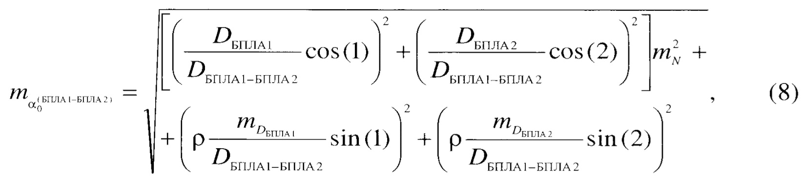
При временных ограничениях БПЛА могут размещаться на некотором удалении от створа приборов, тогда значение СКП передачи ориентирования рассчитывают по формуле (8).With time constraints, UAVs can be located at some distance from the alignment of the instruments, then the value of the RMS of the orientation transfer is calculated by the formula (8).
Таким образом, достигается технический результат, состоящий в снижении трудозатрат (необходимости в составлении проекта трассы, выполнении рекогносцировки, создании поворотных точек хода,Thus, a technical result is achieved, which consists in reducing labor costs (the need to draw up a route project, perform reconnaissance, create turning points of the course,
многочисленных установках приборов и выполнении измерений), повышении оперативности от суток до нескольких часов (за счет сокращения многочисленного количества сторон углового хода до одной воздушной линии между двумя БПЛА вертолетного типа), а также в повышении точности передачи ориентирования с ![]()
![]()
![]()
![]()
Приведенный авторами анализ научно-технической литературы позволяет сделать вывод о патентной новизне предлагаемого способа передачи ориентирования.The analysis of scientific and technical literature given by the authors allows us to conclude about the patent novelty of the proposed method of transferring orientation.
Источники информации, используемые для составления заявки:Sources of information used to draw up the application:
1. Дементьев В.Е. Современная геодезическая техника и ее применение: Учебное пособие для вузов. - Изд. 2-е. - М: Академический Проект, 2008. - 591 с. 1. Dementyev V.E. Modern geodetic technology and its application: Textbook for universities. - Ed. 2nd. - M: Academic Project, 2008 .-- 591 p.
2. Руководство по геодезическим работам. Развитие геодезических сетей специального назначения (РГ-2). Выпуск 2. - М. РИО ВТС, 1961 - 456 с. 2. Guide to geodetic works. Development of geodetic networks for special purposes (RG-2).
3. Инженерно-геодезическое и метеорологическое обеспечение строительства и эксплуатации военных объектов. Учебник для вузов. - СПб.: ВИКА им. А.Ф. Можайского, 1997. - 424 с. 3. Engineering, geodetic and meteorological support for the construction and operation of military facilities. Textbook for universities. - SPb .: VIKA im. A.F. Mozhaisky, 1997 .-- 424 p.
4. Авторское свидетельство СССР №949338. Способ определения угла разворота лимба угломерного прибора / Н.А. Козлов - №2750651/18-10; Заявлено 09.04.79. - Опубликовано 07.08.82. Бюл. №29.4. USSR author's certificate No. 949338. Method for determining the angle of rotation of the limb of a goniometer / N.A. Kozlov - No. 2750651 / 18-10; Stated 04/09/1979. - Published on 08/07/82. Bul. No. 29.
Claims (1)
Priority Applications (1)
| Application Number | Priority Date | Filing Date | Title |
|---|---|---|---|
| RU2021100095A RU2761934C1 (en) | 2021-01-11 | 2021-01-11 | Method for transmitting orientation |
Applications Claiming Priority (1)
| Application Number | Priority Date | Filing Date | Title |
|---|---|---|---|
| RU2021100095A RU2761934C1 (en) | 2021-01-11 | 2021-01-11 | Method for transmitting orientation |
Publications (1)
| Publication Number | Publication Date |
|---|---|
| RU2761934C1 true RU2761934C1 (en) | 2021-12-14 |
Family
ID=79175121
Family Applications (1)
| Application Number | Title | Priority Date | Filing Date |
|---|---|---|---|
| RU2021100095A RU2761934C1 (en) | 2021-01-11 | 2021-01-11 | Method for transmitting orientation |
Country Status (1)
| Country | Link |
|---|---|
| RU (1) | RU2761934C1 (en) |
Citations (4)
| Publication number | Priority date | Publication date | Assignee | Title |
|---|---|---|---|---|
| RU2012853C1 (en) * | 1991-01-02 | 1994-05-15 | Евгений Иванович Смирнов | Method of measuring changes in position of points of object |
| RU2555511C2 (en) * | 2013-01-09 | 2015-07-10 | Юрий Максимович Марков | Method and apparatus for maintaining geodetic direction |
| CN104081156B (en) * | 2012-01-30 | 2017-03-15 | 赫克斯冈技术中心 | There is the instrument of surveying and mapping of scan function and spot measurement pattern |
| RU2657334C1 (en) * | 2017-03-06 | 2018-06-13 | Открытое акционерное общество "Завод им. В.А. Дегтярева" | Method of harmonization of the line of sight of optical device with a longitudinal axle of land vehicle |
-
2021
- 2021-01-11 RU RU2021100095A patent/RU2761934C1/en active
Patent Citations (4)
| Publication number | Priority date | Publication date | Assignee | Title |
|---|---|---|---|---|
| RU2012853C1 (en) * | 1991-01-02 | 1994-05-15 | Евгений Иванович Смирнов | Method of measuring changes in position of points of object |
| CN104081156B (en) * | 2012-01-30 | 2017-03-15 | 赫克斯冈技术中心 | There is the instrument of surveying and mapping of scan function and spot measurement pattern |
| RU2555511C2 (en) * | 2013-01-09 | 2015-07-10 | Юрий Максимович Марков | Method and apparatus for maintaining geodetic direction |
| RU2657334C1 (en) * | 2017-03-06 | 2018-06-13 | Открытое акционерное общество "Завод им. В.А. Дегтярева" | Method of harmonization of the line of sight of optical device with a longitudinal axle of land vehicle |
Similar Documents
| Publication | Publication Date | Title |
|---|---|---|
| RU2558724C2 (en) | Diagnostic complex for determination of pipeline position, and method for determining relative displacement of pipeline as per results of two and more inspection passes of diagnostic complex for determination of pipelines position | |
| CN110095659B (en) | Dynamic test method for pointing accuracy of communication antenna of deep space exploration patrol device | |
| CN110779512B (en) | Flight test route planning method for accuracy identification of measurement and control equipment | |
| RU2487316C1 (en) | Method to use universal system of survey control and navigation | |
| RU2761934C1 (en) | Method for transmitting orientation | |
| Yang et al. | A cost-effective non-orthogonal 3D measurement system | |
| RU2308681C1 (en) | Gyroscopic navigation system for movable objects | |
| RU2650779C1 (en) | Method of the observed from the space craft glacier movement control | |
| RU2356012C1 (en) | Method of determining aircraft course and coordinates | |
| CN102519454A (en) | Selenocentric direction correction method for sun-earth-moon navigation | |
| RU2617147C1 (en) | Method for initial orienting gyroscopic navigation system for land mobiles | |
| RU2440558C1 (en) | Method for automated determination of geodetic data using universal topographic surveying vehicle (utv) | |
| US10656261B2 (en) | Universal method for precise projectile flight prediction | |
| RU2626017C1 (en) | Method of navigating mobile object | |
| CN104457720A (en) | Non-contact monitoring and measuring control marker post | |
| RU2798764C1 (en) | Method for joint determination of coordinates, heights and directional angles | |
| KR101391764B1 (en) | The method of harmonization between inertial navigation system and total station | |
| RU2740686C1 (en) | Method of determining object points coordinates | |
| RU2735311C1 (en) | Direct vector cross-cut method | |
| CN105135944A (en) | Method for acquiring reference azimuth by rocket aiming system through automatic north finding via pendulum type north finder | |
| JPH0446366B2 (en) | ||
| RU2643224C2 (en) | Method for determining motion parameters of glacier observed from spacecraft | |
| RU2692945C1 (en) | Method of orienting mobile objects relative to an object with a known directional angle | |
| Wattan et al. | Using modern survey techniques and 3D software for establishing and correcting control points in area west of Al-Qurna city | |
| RU2642544C2 (en) | Method for determining position of front part of glacier from spacecraft (sc) on near-circular orbit |