KR20230012780A - Method and apparatus for fusing sensor information, and recording medium for recording program performing the method - Google Patents
Method and apparatus for fusing sensor information, and recording medium for recording program performing the method Download PDFInfo
- Publication number
- KR20230012780A KR20230012780A KR1020210093472A KR20210093472A KR20230012780A KR 20230012780 A KR20230012780 A KR 20230012780A KR 1020210093472 A KR1020210093472 A KR 1020210093472A KR 20210093472 A KR20210093472 A KR 20210093472A KR 20230012780 A KR20230012780 A KR 20230012780A
- Authority
- KR
- South Korea
- Prior art keywords
- sensor
- tracks
- track
- association
- sensors
- Prior art date
- Legal status (The legal status is an assumption and is not a legal conclusion. Google has not performed a legal analysis and makes no representation as to the accuracy of the status listed.)
- Pending
Links
Images


Classifications
-
- G—PHYSICS
- G06—COMPUTING OR CALCULATING; COUNTING
- G06V—IMAGE OR VIDEO RECOGNITION OR UNDERSTANDING
- G06V10/00—Arrangements for image or video recognition or understanding
- G06V10/70—Arrangements for image or video recognition or understanding using pattern recognition or machine learning
- G06V10/77—Processing image or video features in feature spaces; using data integration or data reduction, e.g. principal component analysis [PCA] or independent component analysis [ICA] or self-organising maps [SOM]; Blind source separation
- G06V10/80—Fusion, i.e. combining data from various sources at the sensor level, preprocessing level, feature extraction level or classification level
-
- B—PERFORMING OPERATIONS; TRANSPORTING
- B60—VEHICLES IN GENERAL
- B60W—CONJOINT CONTROL OF VEHICLE SUB-UNITS OF DIFFERENT TYPE OR DIFFERENT FUNCTION; CONTROL SYSTEMS SPECIALLY ADAPTED FOR HYBRID VEHICLES; ROAD VEHICLE DRIVE CONTROL SYSTEMS FOR PURPOSES NOT RELATED TO THE CONTROL OF A PARTICULAR SUB-UNIT
- B60W40/00—Estimation or calculation of non-directly measurable driving parameters for road vehicle drive control systems not related to the control of a particular sub unit, e.g. by using mathematical models
- B60W40/02—Estimation or calculation of non-directly measurable driving parameters for road vehicle drive control systems not related to the control of a particular sub unit, e.g. by using mathematical models related to ambient conditions
-
- B—PERFORMING OPERATIONS; TRANSPORTING
- B60—VEHICLES IN GENERAL
- B60W—CONJOINT CONTROL OF VEHICLE SUB-UNITS OF DIFFERENT TYPE OR DIFFERENT FUNCTION; CONTROL SYSTEMS SPECIALLY ADAPTED FOR HYBRID VEHICLES; ROAD VEHICLE DRIVE CONTROL SYSTEMS FOR PURPOSES NOT RELATED TO THE CONTROL OF A PARTICULAR SUB-UNIT
- B60W50/00—Details of control systems for road vehicle drive control not related to the control of a particular sub-unit, e.g. process diagnostic or vehicle driver interfaces
- B60W50/08—Interaction between the driver and the control system
- B60W50/14—Means for informing the driver, warning the driver or prompting a driver intervention
-
- G—PHYSICS
- G01—MEASURING; TESTING
- G01S—RADIO DIRECTION-FINDING; RADIO NAVIGATION; DETERMINING DISTANCE OR VELOCITY BY USE OF RADIO WAVES; LOCATING OR PRESENCE-DETECTING BY USE OF THE REFLECTION OR RERADIATION OF RADIO WAVES; ANALOGOUS ARRANGEMENTS USING OTHER WAVES
- G01S13/00—Systems using the reflection or reradiation of radio waves, e.g. radar systems; Analogous systems using reflection or reradiation of waves whose nature or wavelength is irrelevant or unspecified
- G01S13/86—Combinations of radar systems with non-radar systems, e.g. sonar, direction finder
- G01S13/862—Combination of radar systems with sonar systems
-
- G—PHYSICS
- G01—MEASURING; TESTING
- G01S—RADIO DIRECTION-FINDING; RADIO NAVIGATION; DETERMINING DISTANCE OR VELOCITY BY USE OF RADIO WAVES; LOCATING OR PRESENCE-DETECTING BY USE OF THE REFLECTION OR RERADIATION OF RADIO WAVES; ANALOGOUS ARRANGEMENTS USING OTHER WAVES
- G01S13/00—Systems using the reflection or reradiation of radio waves, e.g. radar systems; Analogous systems using reflection or reradiation of waves whose nature or wavelength is irrelevant or unspecified
- G01S13/86—Combinations of radar systems with non-radar systems, e.g. sonar, direction finder
- G01S13/865—Combination of radar systems with lidar systems
-
- G—PHYSICS
- G01—MEASURING; TESTING
- G01S—RADIO DIRECTION-FINDING; RADIO NAVIGATION; DETERMINING DISTANCE OR VELOCITY BY USE OF RADIO WAVES; LOCATING OR PRESENCE-DETECTING BY USE OF THE REFLECTION OR RERADIATION OF RADIO WAVES; ANALOGOUS ARRANGEMENTS USING OTHER WAVES
- G01S13/00—Systems using the reflection or reradiation of radio waves, e.g. radar systems; Analogous systems using reflection or reradiation of waves whose nature or wavelength is irrelevant or unspecified
- G01S13/86—Combinations of radar systems with non-radar systems, e.g. sonar, direction finder
- G01S13/867—Combination of radar systems with cameras
-
- G—PHYSICS
- G01—MEASURING; TESTING
- G01S—RADIO DIRECTION-FINDING; RADIO NAVIGATION; DETERMINING DISTANCE OR VELOCITY BY USE OF RADIO WAVES; LOCATING OR PRESENCE-DETECTING BY USE OF THE REFLECTION OR RERADIATION OF RADIO WAVES; ANALOGOUS ARRANGEMENTS USING OTHER WAVES
- G01S13/00—Systems using the reflection or reradiation of radio waves, e.g. radar systems; Analogous systems using reflection or reradiation of waves whose nature or wavelength is irrelevant or unspecified
- G01S13/88—Radar or analogous systems specially adapted for specific applications
- G01S13/89—Radar or analogous systems specially adapted for specific applications for mapping or imaging
-
- G—PHYSICS
- G01—MEASURING; TESTING
- G01S—RADIO DIRECTION-FINDING; RADIO NAVIGATION; DETERMINING DISTANCE OR VELOCITY BY USE OF RADIO WAVES; LOCATING OR PRESENCE-DETECTING BY USE OF THE REFLECTION OR RERADIATION OF RADIO WAVES; ANALOGOUS ARRANGEMENTS USING OTHER WAVES
- G01S13/00—Systems using the reflection or reradiation of radio waves, e.g. radar systems; Analogous systems using reflection or reradiation of waves whose nature or wavelength is irrelevant or unspecified
- G01S13/88—Radar or analogous systems specially adapted for specific applications
- G01S13/93—Radar or analogous systems specially adapted for specific applications for anti-collision purposes
- G01S13/931—Radar or analogous systems specially adapted for specific applications for anti-collision purposes of land vehicles
-
- G—PHYSICS
- G06—COMPUTING OR CALCULATING; COUNTING
- G06V—IMAGE OR VIDEO RECOGNITION OR UNDERSTANDING
- G06V20/00—Scenes; Scene-specific elements
- G06V20/50—Context or environment of the image
- G06V20/56—Context or environment of the image exterior to a vehicle by using sensors mounted on the vehicle
-
- B—PERFORMING OPERATIONS; TRANSPORTING
- B60—VEHICLES IN GENERAL
- B60W—CONJOINT CONTROL OF VEHICLE SUB-UNITS OF DIFFERENT TYPE OR DIFFERENT FUNCTION; CONTROL SYSTEMS SPECIALLY ADAPTED FOR HYBRID VEHICLES; ROAD VEHICLE DRIVE CONTROL SYSTEMS FOR PURPOSES NOT RELATED TO THE CONTROL OF A PARTICULAR SUB-UNIT
- B60W50/00—Details of control systems for road vehicle drive control not related to the control of a particular sub-unit, e.g. process diagnostic or vehicle driver interfaces
- B60W2050/0001—Details of the control system
- B60W2050/0019—Control system elements or transfer functions
- B60W2050/0022—Gains, weighting coefficients or weighting functions
- B60W2050/0025—Transfer function weighting factor
-
- B—PERFORMING OPERATIONS; TRANSPORTING
- B60—VEHICLES IN GENERAL
- B60W—CONJOINT CONTROL OF VEHICLE SUB-UNITS OF DIFFERENT TYPE OR DIFFERENT FUNCTION; CONTROL SYSTEMS SPECIALLY ADAPTED FOR HYBRID VEHICLES; ROAD VEHICLE DRIVE CONTROL SYSTEMS FOR PURPOSES NOT RELATED TO THE CONTROL OF A PARTICULAR SUB-UNIT
- B60W2420/00—Indexing codes relating to the type of sensors based on the principle of their operation
-
- B—PERFORMING OPERATIONS; TRANSPORTING
- B60—VEHICLES IN GENERAL
- B60W—CONJOINT CONTROL OF VEHICLE SUB-UNITS OF DIFFERENT TYPE OR DIFFERENT FUNCTION; CONTROL SYSTEMS SPECIALLY ADAPTED FOR HYBRID VEHICLES; ROAD VEHICLE DRIVE CONTROL SYSTEMS FOR PURPOSES NOT RELATED TO THE CONTROL OF A PARTICULAR SUB-UNIT
- B60W2556/00—Input parameters relating to data
- B60W2556/35—Data fusion
-
- B—PERFORMING OPERATIONS; TRANSPORTING
- B60—VEHICLES IN GENERAL
- B60Y—INDEXING SCHEME RELATING TO ASPECTS CROSS-CUTTING VEHICLE TECHNOLOGY
- B60Y2400/00—Special features of vehicle units
- B60Y2400/30—Sensors
Landscapes
- Engineering & Computer Science (AREA)
- Remote Sensing (AREA)
- Radar, Positioning & Navigation (AREA)
- Physics & Mathematics (AREA)
- General Physics & Mathematics (AREA)
- Theoretical Computer Science (AREA)
- Computer Networks & Wireless Communication (AREA)
- Automation & Control Theory (AREA)
- Computer Vision & Pattern Recognition (AREA)
- Multimedia (AREA)
- Transportation (AREA)
- Mechanical Engineering (AREA)
- Evolutionary Computation (AREA)
- General Health & Medical Sciences (AREA)
- Medical Informatics (AREA)
- Software Systems (AREA)
- Databases & Information Systems (AREA)
- Computing Systems (AREA)
- Artificial Intelligence (AREA)
- Health & Medical Sciences (AREA)
- Electromagnetism (AREA)
- Human Computer Interaction (AREA)
- Mathematical Physics (AREA)
- Radar Systems Or Details Thereof (AREA)
- Traffic Control Systems (AREA)
Abstract
Description
실시 예는 센서 정보 융합 방법 및 장치와 이 방법을 실행하기 위한 프로그램을 기록한 기록 매체에 관한 것이다.Embodiments relate to a sensor information fusion method and apparatus, and a recording medium recording a program for executing the method.
차량의 정확한 위치 찾기, 정밀 측위 기술 및 디지털 맵 기술과, 운전자의 운행 상태를 체크해 주는 첨단 운전자 보조 시스템(Advanced Driving Assistant System: ADAS) 등에서 센서 융합 기술이 이용되고 있다.Sensor convergence technology is used in the precise positioning of vehicles, precise positioning technology, digital map technology, and advanced driver assistance systems (ADAS) that check the driver's driving condition.
센서 융합 기술은 차량에 장착된 복수의 센서 예를 들어 전방 레이더(RaDAR: Radio Detecting And Ranging), 전방 카메라, 측방 레이더에서 센싱된 정보를 융합하는 기술로서, 자차 주변의 상황을 신뢰도 높게 인지할 수 있도록 할 수 있다. 예를 들어, 자율 주행 레벨이 증가함에 따라, 높은 신뢰성과 정확성을 갖는 센서 정보 융합 기술이 요구되고 있다.Sensor fusion technology is a technology that fuses information sensed from multiple sensors mounted on a vehicle, such as front radar (RaDAR: Radio Detecting And Ranging), front camera, and side-view radar, and can recognize the situation around the vehicle with high reliability. can make it For example, as the level of autonomous driving increases, sensor information fusion technology having high reliability and accuracy is required.
실시 예는 복수의 센서에서 센싱된 정보를 정확하고 신뢰성 높게 융합할 수 있는 센서 정보 융합 방법 및 장치와 이 방법을 실행하기 위한 프로그램을 기록한 기록 매체를 제공한다.Embodiments provide a sensor information fusion method and apparatus capable of integrating information sensed by a plurality of sensors accurately and reliably, and a recording medium recording a program for executing the method.
실시 예에서 해결하고자 하는 기술적 과제는 이상에서 언급한 기술적 과제로 제한되지 않으며, 언급하지 않은 또 다른 기술적 과제는 아래의 기재로부터 본 발명이 속하는 기술 분야에서 통상의 지식을 가진 자에게 명확하게 이해될 수 있을 것이다.Technical problems to be solved in the embodiments are not limited to the above-mentioned technical problems, and other technical problems not mentioned will be clearly understood by those skilled in the art from the description below. You will be able to.
일 실시 예에 의한 센서 정보 융합 방법은, 차량 주변에 위치한 타겟에 대해 복수의 센서 각각으로부터 N 개의 센서 트랙을 획득하여 M 개의 기준 트랙에 대한 상기 N 개의 센서 트랙의 연관값을 연산하여 행렬 형식으로 저장하는 단계; 및 상기 행렬에 대해 상기 연관값을 최소화하는 기준 트랙 및 센서 트랙의 배열을 연산하여, 상기 복수의 센서에서 연산된 상기 기준 트랙 및 센서 트랙의 배열에 따라 상기 타겟에 대한 센싱 정보 융합 결과를 출력하는 단계;를 포함할 수 있다.According to an exemplary embodiment, a sensor information fusion method obtains N sensor tracks from each of a plurality of sensors for a target located around a vehicle, calculates association values of the N sensor tracks with M reference tracks, and converts them into a matrix form. storing; and calculating an array of reference tracks and sensor tracks that minimize the correlation value with respect to the matrix, and outputting a sensing information fusion result for the target according to the array of the reference tracks and sensor tracks calculated in the plurality of sensors. step; may be included.
예를 들어, 상기 연관값을 연산하여 행렬 형식으로 저장하는 단계는, 상기 기준 트랙 박스와 센서 트랙 박스 간의 거리, 상기 기준 트랙 박스와 센서 트랙 박스가 점유하는 전체 영역의 크기, 상기 기준 트랙 박스와 센서 트랙 박스의 중첩 영역의 크기 중 적어도 어느 하나에 기초하여 상기 연관값을 산출하는 단계를 포함할 수 있다.For example, the step of calculating the association value and storing it in a matrix form may include the distance between the reference track box and the sensor track box, the size of the entire area occupied by the reference track box and the sensor track box, the reference track box and Calculating the association value based on at least one of sizes of overlapping regions of sensor track boxes may be included.
예를 들어, 상기 연관값은, 상기 기준 트랙 박스와 상기 센서 트랙 박스 간 유사도가 높을 수록 작은 값으로 산출될 수 있다.For example, the association value may be calculated as a smaller value as the similarity between the reference track box and the sensor track box increases.
예를 들어, 상기 타겟에 대한 센싱 정보 융합 결과를 출력하는 단계는, 상기 행렬에 대해 기 설정된 할당 알고리즘을 적용하여 상기 연관값을 최소화하는 기준 트랙 및 센서 트랙의 배열을 산출하는 단계를 포함할 수 있다.For example, the outputting of the sensing information fusion result for the target may include calculating an arrangement of a reference track and a sensor track that minimizes the association value by applying a predetermined allocation algorithm to the matrix. there is.
예를 들어, 상기 타겟에 대한 센싱 정보 융합 결과를 출력하는 단계는, 상기 복수의 센서에서 산출된 상기 기준 트랙 및 센서 트랙의 배열을 상기 기준 트랙에 대한 상기 복수의 센서 정보가 저장된 연관맵(Association Map)에 업데이트하는 단계를 포함할 수 있다.For example, the outputting of the sensing information fusion result for the target may include the reference track and the arrangement of the sensor tracks calculated from the plurality of sensors in an association map in which information of the plurality of sensors for the reference track is stored. Map) may be updated.
예를 들어, 상기 타겟에 대한 센싱 정보 융합 결과를 출력하는 단계는, 상기 연관맵(Association Map)과 상기 연관값에 기초하여 상기 복수의 센서의 상기 센서 트랙을 융합하여 생성되는 퓨전 트랙을 업데이트하는 단계를 포함할 수 있다.For example, the outputting of the sensing information fusion result for the target may include updating a fusion track generated by fusing the sensor tracks of the plurality of sensors based on the association map and the association value. steps may be included.
예를 들어, 상기 타겟에 대한 센싱 정보 융합 결과를 출력하는 단계는, 상기 연관값에 기초하여 상기 센서 측정값에 대해 가중치 팩터를 설정하는 단계; 및 상기 가중치 팩터에 따라 상기 퓨전 트랙의 위치, 속도, 폭/너비 중 적어도 어느 하나를 업데이트하는 단계;를 포함할 수 있다.For example, the outputting of the sensing information fusion result for the target may include setting a weight factor for the sensor measurement value based on the association value; and updating at least one of position, speed, and width/width of the fusion track according to the weight factor.
다른 실시 예에 의하며, 차량 주변에 위치한 타겟에 대해 복수의 센서 각각으로부터 N 개의 센서 트랙을 획득하여 M 개의 기준 트랙에 대한 상기 N 개의 센서 트랙의 연관값을 연산하여 행렬 형식으로 저장하는 기능; 및 상기 행렬에 대해 상기 연관값을 최소화하는 기준 트랙 및 센서 트랙의 배열을 연산하여, 상기 복수의 센서에서 연산된 상기 기준 트랙 및 센서 트랙의 배열에 따라 상기 타겟에 대한 센싱 정보 융합 결과를 출력하는 기능을 구현하는 프로그램을 기록한 컴퓨터로 읽혀질 수 있다.According to another embodiment, a function of obtaining N sensor tracks from each of a plurality of sensors for a target located around a vehicle, calculating correlation values of the N sensor tracks with respect to M reference tracks, and storing them in a matrix form; and calculating an array of reference tracks and sensor tracks that minimize the correlation value with respect to the matrix, and outputting a sensing information fusion result for the target according to the array of the reference tracks and sensor tracks calculated in the plurality of sensors. It can be read by a computer that writes a program that implements the function.
또 다른 실시 예에 의한 센서 정보 융합 장치는, 차량 주변에 위치한 타겟에 대해 객체 검출을 기반으로 N 개의 센서 트랙을 생성하여 출력하는 복수의 센서를 포함하는 센서부; 및 차량 주변에 위치한 타겟에 대해 복수의 센서 각각으로부터 상기 N 개의 센서 트랙을 획득하여 M 개의 기준 트랙에 대한 상기 N 개의 센서 트랙의 연관값을 연산하여 행렬 형식으로 저장하고, 상기 행렬에 대해 상기 연관값을 최소화하는 기준 트랙 및 센서 트랙의 배열을 연산하여, 상기 복수의 센서에서 연산된 상기 기준 트랙 및 센서 트랙의 배열에 따라 상기 타겟에 대한 센싱 정보 융합 결과를 출력하는 제어부;를 포함할 수 있다.An apparatus for integrating sensor information according to another embodiment includes a sensor unit including a plurality of sensors for generating and outputting N sensor tracks based on object detection with respect to targets located around a vehicle; and acquiring the N sensor tracks from each of a plurality of sensors for targets located around the vehicle, calculating and storing relation values of the N sensor tracks with respect to M reference tracks in a matrix form, and storing the association values for the matrix. and a control unit that calculates an array of reference tracks and sensor tracks that minimize values, and outputs a result of fusion of sensing information for the target according to the array of the reference tracks and sensor tracks calculated by the plurality of sensors. .
예를 들어, 상기 제어부는, 상기 연관값을 연산하여 상기 행렬 형식으로 저장하는 연관값 행렬 생성부; 상기 행렬에 대해 기 설정된 할당 알고리즘을 적용하여 상기 연관값을 최소화하는 기준 트랙 및 센서 트랙의 배열을 산출하는 연관 센서 할당부; 상기 복수의 센서에서 산출된 상기 기준 트랙 및 센서 트랙의 배열에 따라 상기 복수의 센서의 센서 트랙을 융합하기 위한 연관맵을 생성하는 연관맵 생성부; 및 상기 연관맵 및 상기 연관값에 기초하여 상기 타겟에 대한 센싱 정보 융합 결과를 출력하는 컨버전부;를 포함할 수 있다.For example, the control unit may include: an association value matrix generator that calculates the association values and stores them in the form of a matrix; an association sensor allocator calculating an arrangement of reference tracks and sensor tracks that minimizes the association value by applying a preset assignment algorithm to the matrix; a correlation map generating unit generating a correlation map for fusing the sensor tracks of the plurality of sensors according to the arrangement of the reference tracks and sensor tracks calculated by the plurality of sensors; and a conversion unit outputting a fusion result of sensing information for the target based on the association map and the association value.
예를 들어, 상기 연관값 행렬 생성부는, 상기 기준 트랙 박스와 센서 트랙 박스 간의 거리, 상기 기준 트랙 박스와 센서 트랙 박스가 점유하는 전체 영역의 크기, 상기 기준 트랙 박스와 센서 트랙 박스의 중첩 영역의 크기 중 적어도 어느 하나에 기초하여 상기 연관값을 산출할 수 있다.For example, the association value matrix generator may determine the distance between the reference track box and the sensor track box, the size of the entire area occupied by the reference track box and the sensor track box, and the overlapping area of the reference track box and the sensor track box. The association value may be calculated based on at least one of the sizes.
예를 들어, 상기 연관 센서 할당부는, 상기 행렬에 대해 헝가리안 알고리즘(Hungarian algorithm)을 적용하여 상기 기준 트랙 및 센서 트랙의 배열을 산출할 수 있다.For example, the associated sensor allocator may calculate the arrangement of the reference track and the sensor track by applying a Hungarian algorithm to the matrix.
예를 들어, 상기 연관맵 생성부는, 상기 복수의 센서에서 산출된 상기 기준 트랙 및 센서 트랙의 배열을 상기 기준 트랙에 대한 상기 복수의 센서 정보가 저장된 연관맵(Association Map)에 업데이트할 수 있다.For example, the association map generation unit may update an arrangement of the reference tracks and sensor tracks calculated from the plurality of sensors to an association map in which information of the plurality of sensors for the reference tracks is stored.
예를 들어, 상기 컨버전부는, 상기 연관맵(Association Map)과 상기 연관값에 기초하여 상기 복수의 센서의 상기 센서 트랙을 융합하여 생성되는 퓨전 트랙을 업데이트할 수 있다.For example, the conversion unit may update a fusion track generated by fusing the sensor tracks of the plurality of sensors based on the association map and the association value.
예를 들어, 상기 컨버전부는, 상기 연관값에 기초하여 상기 센서 측정값에 대해 가중치 팩터를 설정하고, 설정된 상기 가중치 팩터에 따라 상기 퓨전 트랙의 위치, 속도, 폭/너비 중 적어도 어느 하나를 업데이트할 수 있다.For example, the conversion unit sets a weight factor for the sensor measurement value based on the association value, and updates at least one of the position, speed, and width/width of the fusion track according to the set weight factor. can
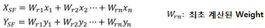
예를 들어, 상기 가중치 팩터는 다음의 수학식에 따라 산출될 수 있다.For example, the weight factor may be calculated according to the following equation.
[수학식][mathematical expression]
실시 예에 따른 센서 정보 융합 방법 및 장치와 이 방법을 실행하기 위한 프로그램을 기록한 기록 매체는, 센서 출력의 거리, ID 유지성 등을 포함하는 연관값(AssocCost)을 할당 행렬 형태로 저장하고, 최적 할당 알고리즘을 적용하여 전체 센서 출력에 대해서 최적의 연관 결과를 도출함으로써 센서 정보 융합 성능을 향상시킬 수 있다.The sensor information convergence method and apparatus according to the embodiment and the recording medium recording the program for executing the method store association values (AssocCost) including the distance of the sensor output, ID retention, etc. in the form of an allocation matrix, and optimal allocation. The sensor information fusion performance can be improved by applying an algorithm to derive an optimal correlation result for all sensor outputs.
또한, 본 실시 예에서 얻을 수 있는 효과는 이상에서 언급한 효과들로 제한되지 않으며 언급하지 않은 또 다른 효과는 아래의 기재로부터 본 발명이 속하는 분야에서 통상의 지식을 가진 자에게 명확하게 이해될 수 있을 것이다.In addition, the effects obtainable in this embodiment are not limited to the effects mentioned above, and other effects not mentioned can be clearly understood by those skilled in the art from the description below. There will be.
도 1은 실시 예에 의한 센서 정보 융합 장치를 포함하는 차량의 블록도이다.
도 2는 도 1에 도시된 프로세서의 실시 예의 블록도이다.
도 3 및 도 4는 도 2의 연관값 행렬 생성부의 연관값(AssocCost) 산출 방법을 설명하기 위한 도면이다.
도 5는 연관값(AssocCost) 할당 행렬 설정 방법을 설명하기 위한 도면이다.
도 6은 도 2의 연관 센서 할당부의 센서 할당 방법을 설명하기 위한 도면이다.
도 7은 도 2의 연관맵 생성부의 연관맵(Association Map) 생성 방법을 설명하기 위한 도면이다.
도 8은 실시 예에 의한 센서 정보 융합 방법을 설명하기 위한 플로우차트이다.
도 9는 비교 예에 의한 센서 정보 융합 방법을 설명하기 위한 플로우차트이다.
도 10은 실시 예와 비교 예에 따른 센서 정보 융합 결과를 대비하여 설명하기 위한 도면이다.1 is a block diagram of a vehicle including a sensor information fusion device according to an embodiment.
FIG. 2 is a block diagram of an embodiment of the processor shown in FIG. 1 .
3 and 4 are diagrams for explaining a method of calculating an association value (AssocCost) of the association value matrix generator of FIG. 2 .
5 is a diagram for explaining a method of setting an association value (AssocCost) allocation matrix.
FIG. 6 is a diagram for explaining a method of allocating sensors of the related sensor allocating unit of FIG. 2 .
FIG. 7 is a diagram for explaining a method of generating an association map of the association map generator of FIG. 2 .
8 is a flowchart for explaining a sensor information fusion method according to an embodiment.
9 is a flowchart for explaining a sensor information fusion method according to a comparative example.
10 is a diagram for explaining a comparison of sensor information fusion results according to an embodiment and a comparative example.
이하, 본 발명을 구체적으로 설명하기 위해 실시 예를 들어 설명하고, 발명에 대한 이해를 돕기 위해 첨부도면을 참조하여 상세하게 설명하기로 한다. 그러나, 본 발명에 따른 실시 예들은 여러 가지 다른 형태로 변형될 수 있으며, 본 발명의 범위가 아래에서 상술하는 실시 예들에 한정되는 것으로 해석되지 않아야 한다. 본 발명의 실시 예들은 당 업계에서 평균적인 지식을 가진 자에게 본 발명을 보다 완전하게 설명하기 위해서 제공되는 것이다.Hereinafter, examples will be described in order to explain the present invention in detail, and will be described in detail with reference to the accompanying drawings to help understanding of the present invention. However, embodiments according to the present invention can be modified in many different forms, and the scope of the present invention should not be construed as being limited to the embodiments described below. Embodiments of the present invention are provided to more completely explain the present invention to those skilled in the art.
본 실시 예의 설명에 있어서, 각 구성요소(element)의 "상(위) 또는 하(아래)(on or under)"에 형성되는 것으로 기재되는 경우에 있어, 상(위) 또는 하(아래)(on or under)는 두 개의 구성요소(element)가 서로 직접(directly)접촉되거나 하나 이상의 다른 구성요소(element)가 상기 두 구성요소(element) 사이에 배치되어(indirectly) 형성되는 것을 모두 포함한다.In the description of this embodiment, in the case where it is described as being formed on or under each element, the upper (above) or lower (below) ( on or under) includes both that two elements are directly in contact with each other or that one or more other elements are disposed between the two elements (indirectly).
또한 "상(위)" 또는 "하(아래)(on or under)"로 표현되는 경우 하나의 구성요소(element)를 기준으로 위쪽 방향뿐만 아니라 아래쪽 방향의 의미도 포함할 수 있다.In addition, when expressed as "upper (up)" or "lower (under) (on or under)", it may include the meaning of not only an upward direction but also a downward direction based on one element.
또한, 이하에서 이용되는 "제1" 및 "제2," "상/상부/위" 및 "하/하부/아래" 등과 같은 관계적 용어들은, 그런 실체 또는 요소들 간의 어떠한 물리적 또는 논리적 관계 또는 순서를 반드시 요구하거나 내포하지는 않으면서, 어느 한 실체 또는 요소를 다른 실체 또는 요소와 구별하기 위해서 이용될 수도 있다.In addition, relational terms such as "first" and "second", "upper/upper/upper" and "lower/lower/lower" used below refer to any physical or logical relationship or It may be used to distinguish one entity or element from another, without necessarily requiring or implying an order.
기존의 센서정보 융합 방법은 다종 센서를 연관(Association)시키는 과정에서 각 기준 센서와의 최소거리를 기준으로 연관 센서를 선정하고, ID 유지성을 추가 판단하는 과정을 통해 최종 연관 센서를 선정하였던 데 반해, 본 실시예의 센서정보 융합 방법은 복수개의 센서를 통해 센싱되는 복수개의 트랙정보를 통합하여 센서 출력의 거리, ID 유지성 등을 포함하는 연관값(AssocCost)을 산출함으로써 최적 배치된 다종 센서 연관 결과를 도출하는 기술을 제안한다.Existing sensor information convergence methods select related sensors based on the minimum distance from each reference sensor in the process of associating multiple types of sensors, and select the final related sensor through the process of additionally determining ID retention. , The sensor information convergence method of this embodiment integrates a plurality of track information sensed through a plurality of sensors to calculate an association value (AssocCost) including distance of sensor output, ID retention, etc. Suggest techniques for derivation.
이하, 실시 예에 의한 센서 정보 융합 방법 및 장치와 이 방법을 실행하기 위한 프로그램을 기록한 기록 매체를 첨부된 도면을 참조하여 다음과 같이 설명한다. 편의상, 데카르트 좌표계(x축, y축, z축)를 이용하여 센서 정보 융합 방법 및 장치와 이 방법을 실행하기 위한 프로그램을 기록한 기록 매체를 설명하지만, 다른 좌표계에 의해서도 이를 설명할 수 있음은 물론이다.Hereinafter, a sensor information fusion method and apparatus according to embodiments and a recording medium recording a program for executing the method will be described as follows with reference to the accompanying drawings. For convenience, a sensor information fusion method and apparatus using a Cartesian coordinate system (x-axis, y-axis, z-axis) and a recording medium recording a program for executing this method are described, but other coordinate systems can also be described. to be.
도 1은 실시예에 따른 센서 정보 융합 장치(120)가 구비된 차량(100)의 구성을 개략적으로 도시한 블록도이다.1 is a block diagram schematically illustrating the configuration of a
차량(100)은 센싱 장치(110) 및 센서 정보 융합 장치(120)를 포함할 수 있다. 실시 예에 따른 센서 정보 융합 장치(120)는 차량(100)의 내부에 구현될 수 있다. 이때, 센서 정보 융합 장치(120)는 차량(100)의 내부 제어 유닛들(미도시)과 일체로 형성될 수 있으며, 별도의 장치로 구현되어 별도의 연결 수단에 의해 차량(100)의 제어 유닛들과 연결될 수도 있다.The
센싱 장치(110)는 차량(100)의 주변에 위치한 타겟 객체의 위치, 객체의 속도, 객체의 이동 방향 및/또는 객체의 종류(예: 차량, 보행자, 자전거 또는 모터사이클 등)에 대한 정보를 획득하는 하나 이상의 센서를 포함할 수 있다. 이러한, 센싱 장치(110)는 초음파 센서, 레이더, 카메라, 레이저 스캐너 및/또는 코너 레이더, 라이다, 등을 포함할 수 있다. 센싱장치(110)는 센서에 입력되는 검출 포인트(detection point)에 기초하여 객체(object)를 검출하고, 검출한 객체를 기반으로 센서 트랙(track) 정보를 생성할 수 있다. 단일 센서는 제1 내지 제 N(N은 자연수) 센서 트랙을 생성하여 출력할 수 있으며, 센싱 장치(110)는 복수의 센서를 포함하므로, 각각의 센서로부터 제1 내지 제 N 센서 트랙이 생성될 수 있다.The
센서 정보 융합 장치(120)는 각 센서로부터 제1 내지 제 N 센서 트랙을 획득하여 기준트랙에 대한 센서 트랙의 연관값(AssocCost) 행렬을 생성하고, 각 센서별로 생성된 연관값 행렬들에 대해 할당 문제(assignment problem)의 최적해를 찾을 수 있는 알고리즘을 적용하여 최적의 연관 센서를 할당함으로써 복수의 센서의 결과를 하나의 연관맵(Association Map)으로 융합하여 센서 융합 결과를 출력할 수 있다.The sensor information convergence device 120 obtains the first to Nth sensor tracks from each sensor, generates an association value matrix (AssocCost) of the sensor track with respect to the reference track, and allocates the association value matrices generated for each sensor. By applying an algorithm capable of finding an optimal solution to an assignment problem and assigning an optimal association sensor, results of a plurality of sensors may be fused into one association map, and a sensor fusion result may be output.
이러한, 센싱 정보 융합 장치(120)는 메모리와 각 동작을 처리하는 프로세서를 포함하는 독립적인 하드웨어 장치 형태로 구현될 수 있으며, 마이크로프로세서나 범용 컴퓨터 시스템과 같은 다른 하드웨어 장치에 포함된 형태로 구동될 수 있다. 예컨대, 센서 정보 융합 장치(120)는 통신부(122), 저장부(124), 인터페이스부(126) 및 프로세서(processor)(128)를 포함할 수 있다.The sensing information convergence device 120 may be implemented in the form of an independent hardware device including a memory and a processor for processing each operation, and may be driven in a form included in other hardware devices such as a microprocessor or a general-purpose computer system. can For example, the sensor information fusion device 120 may include a
통신부(122)는 센싱 장치(110) 내의 센서들로부터 센싱된 결과를 수신할 수 있다. 통신부(122)는 무선 또는 유선 연결을 통해 신호를 송신 및 수신하기 위해 다양한 전자 회로로 구현되는 하드웨어 장치로서, 차량 내 네트워크 통신 기술, 차량 외부의 서버, 인프라, 타 차량 등과 무선 인터넷 접속 또는 근거리 통신(Short Range Communication) 기술을 이용하여 V2I 통신을 수행할 수 있다. 여기서, 차량 내 네트워크 통신 기술로는 CAN(Controller Area Network) 통신, LIN(Local Interconnect Network) 통신, 플렉스레이(Flex??Ray) 통신 등이 있으며 이를 통해 차량 내 통신을 수행할 수 있다. 또한, 무선 통신 기술로는 무선 인터넷 기술로서 무선랜(Wireless LAN, WLAN), 와이브로(Wireless Broadband, Wibro), 와이파이(Wi??Fi), 와이맥스(World Interoperability for Microwave Access, Wimax) 등이 포함될 수 있다. 또한, 근거리 통신 기술로는 블루투스(Bluetooth), 지그비(ZigBee), UWB(Ultra Wideband), RFID(Radio Frequency Identification), 적외선통신(Infrared Data Association, IrDA) 등이 포함될 수 있다.The
저장부(124)에는 센싱 장치(110)의 센싱 결과, 프로세서(128)에 의해 획득된 데이터, 프로세서(128)가 동작하는데 필요한 데이터 및/또는 알고리즘 등이 저장될 수 있다. 저장부(124)에는 카메라, 라이다, 레이더 등의 센서로부터 입력된 트랙정보들이 저장될 수 있고, 센싱 정보 융합을 위한 프로세싱 시 생성되는 값들이 저장될 수 있다. 이러한 저장부(124)는 플래시 메모리 타입(flash memory type), 하드디스크 타입(hard disk type), 마이크로 타입(micro type), 및 카드 타입(예컨대, SD 카드(Secure Digital Card) 또는 XD 카드(eXtream Digital Card)) 등의 메모리와, 램(RAM, Random Access Memory), SRAM(Static RAM), 롬(ROM, Read??Only Memory), PROM(Programmable ROM), EEPROM(Electrically Erasable PROM), 자기 메모리(MRAM, Magnetic RAM), 자기 디스크(magnetic disk), 및 광디스크(optical disk) 타입의 메모리 중 적어도 하나의 타입의 기록 매체(storage medium)를 포함할 수 있다.The
인터페이스부(126)는 사용자로부터의 제어 명령을 입력 받기 위한 입력수단과 차량(100)의 동작 상태 및 결과 등을 출력하는 출력수단을 포함할 수 있다. 여기서, 입력수단은 키 버튼을 포함할 수 있으며, 마우스, 조이스틱, 조그셔틀, 스타일러스 펜 등을 포함할 수도 있다. 또한, 입력수단은 디스플레이 상에 구현되는 소프트 키를 포함할 수도 있다.The
출력수단은 디스플레이 및 스피커와 같은 음성출력수단을 포함할 수도 있다. 이때, 터치 필름, 터치 시트, 터치 패드 등의 터치 센서가 디스플레이에 구비되는 경우, 디스플레이는 터치 스크린으로 동작하며, 입력수단과 출력수단이 통합된 형태로 구현될 수 있다. 일 예로 출력수단은 센싱 장치(110)에 의해 센싱된 정보를 출력하거나, 센서 정보 융합 장치(120)에 의해 융합된 센서 정보를 출력할 수 있다.The output means may include audio output means such as a display and a speaker. In this case, when a touch sensor such as a touch film, a touch sheet, or a touch pad is provided in a display, the display operates as a touch screen, and an input unit and an output unit may be integrated. For example, the output unit may output information sensed by the
프로세서(128)는 통신부(122), 저장부(124), 인터페이스부(126) 등과 전기적으로 연결될 수 있고, 각 구성들을 전기적으로 제어할 수 있으며, 소프트웨어의 명령을 실행하는 전기 회로가 될 수 있으며, 이에 의해 후술하는 다양한 데이터 처리 및 계산을 수행할 수 있다. 프로세서(128)는 예를 들어, 차량에 탑재되는 ECU(electronic control unit), MCU(Micro Controller Unit) 또는 다른 하위 제어기일 수 있다. 이러한 프로세서(128)는 실시예에 따른 센서 정보 융합 방법을 수행할 수 있다.The
도 2는 도 1에 도시된 프로세서(128)의 실시 예(128A)의 블록도로서, 연관값 행렬 생성부(210), 연관 센서 할당부(220), 연관 맵 생성부(230) 및 컨버전부(240)를 포함할 수 있다.FIG. 2 is a block diagram of an
연관값 행렬 생성부(210)는 각 센서로부터 N개의 센서 트랙 정보를 입력받아 M개의 기준 트랙에 대한 N개의 센서 트랙의 연관값(AssocCost) 행렬을 생성할 수 있다.The association
연관 센서 할당부(220)는 각 센서별로 생성된 연관값 행렬들에 대해 할당 문제(assignment problem)의 최적해를 찾을 수 있는 알고리즘을 적용하여 최적의 연관 센서를 할당한다.The
연관 맵 생성부(230)는 할당된 연관 센서들을 하나의 연관맵(Association Map)으로 융합한다.The
컨버전부(240)는 연관맵(Association Map)에 기초하여 연관된 센서 정보를 업데이트 함으로써, 센서 융합 결과를 출력할 수 있다.The
이상의 프로세서(128)의 상세 기능을 도 3 내지 도 7을 참조하여 상세히 설명한다. 도 3 및 도 4는 도 2의 연관값 행렬 생성부(210)의 연관값(AssocCost) 행렬 생성 방법을 설명하기 위한 도면이고, 도 5는 연관값(AssocCost) 할당 행렬 설정 방법을 설명하기 위한 도면이며, 도 6은 도 2의 연관 센서 할당부(220)의 할당 행렬 설정 방법을 설명하기 위한 도면이고, 도 7은 도 2의 연관맵 생성부(230)의 연관맵(Association Map) 생성 방법을 설명하기 위한 도면이다.Detailed functions of the
도 3 및 도 4를 참조하여 연관값 행렬 생성부(210)의 연관값(AssocCost) 행렬 생성 방법을 상세히 설명한다.A method of generating an association value matrix (AssocCost) by the association
연관값 행렬 생성부(210)는 각 센서로부터 N개의 센서 트랙을 입력받아 M개의 기준 트랙에 대한 N개의 센서 트랙의 연관값(AssocCost) 행렬을 생성할 수 있다.The association
연관값 행렬 생성부(210)에 입력을 제공하는 센싱장치(110)는 센서에 입력되는 검출 포인트(detection point)에 기초하여 객체(object)를 검출하고, 검출한 객체를 기반으로 센서 트랙 정보를 생성할 수 있다. 단일 센서는 제1 내지 제 N(N은 자연수) 센서 트랙을 생성하여 출력할 수 있으므로, 연관값 행렬 생성부(210)는 복수의 센서로부터 제1 내지 제 N 센서 트랙을 획득할 수 있다.The
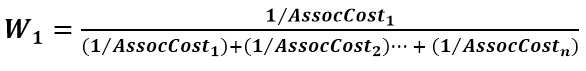
연관값 행렬 생성부(210)는 제1 내지 제 M 기준 트랙에 대한 제1 내지 제 N 센서 트랙의 연관값(AssocCost)을 ![]()
![]()
도 3을 참조하면, 기준 트랙(RT)과 센서 트랙(ST)은 동일한 객체에 대한 정보이지만, 센서의 특성에 따라 다르게 인식될 수 있다. 이러한 차이는 기준 트랙(RT)의 기준점(RT_P)와 센서 트랙(ST)의 기준점(ST_P) 간 거리 오차(Derror)로 산출할 수 있다. 이에, 연관값(AssocCost)은 기준 트랙(RT)과 센서 트랙(ST)의 기준점 간 거리(Distance Error)에 이전 ID 센서 트랙에 대한 코스트를 낮추기 위한 팩터와, 센서별 신뢰도 팩터를 반영하여 산출될 수 있다. 이를 수식으로 나타내면 다음의 [수학식 1]과 같이 설정될 수 있다.Referring to FIG. 3 , the reference track RT and the sensor track ST are information about the same object, but may be recognized differently according to the characteristics of the sensor. This difference can be calculated as a distance error Derror between the reference point RT_P of the reference track RT and the reference point ST_P of the sensor track ST. Accordingly, the association value AssocCost may be calculated by reflecting a factor for lowering the cost for the previous ID sensor track and a reliability factor for each sensor in the distance error between the reference points of the reference track RT and the sensor track ST. can Expressing this as a formula, it can be set as in the following [Equation 1].
![]()
![]()
여기서, here,
![]()
![]()
![]()
![]()
상기 [수학식 1]의 Distance Error는 기준 트랙(RT)과 센서 트랙(ST)의 기준점 간 거리의 차이로 산출될 수 있다. 기준점 간 거리는 다차원 공간에서 두점 간의 거리를 산출하는 유클리드 거리(Euclidean Distance) 또는 확률분포상 거리를 산출하는 마할라노비스 거리(Mahalanobis Distance) 등의 연산방식으로 획득될 수 있다.The distance error in [Equation 1] can be calculated as a difference between the distances between the reference points of the reference track RT and the sensor track ST. The distance between reference points may be obtained by an arithmetic method such as a Euclidean distance that calculates a distance between two points in a multidimensional space or a Mahalanobis distance that calculates a distance on a probability distribution.
연관값을 산출하는 수식은 센서 연관 기준에 따라 다양하게 변형될 수 있다.An equation for calculating a correlation value may be variously modified according to a sensor correlation criterion.
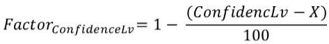
도 4를 참조하면, 기준 트랙(RT)과 센서 트랙(ST)은 동일한 객체에 대한 정보이지만, (a)와 같이 센서의 특성에 따라 다르게 인식될 수 있다. 이러한 차이는 도 4의 (b)와 같이 인식되는 기준 트랙(RT)과 센서 트랙(ST)의 전체 영역(Areatotal)과 도 4의 (c)와 같이 인식되는 기준 트랙(RT)과 센서 트랙(ST)의 오버랩 영역(Areaoverlap) 간의 비율로 산출할 수 있다. 기준 트랙(RT)과 센서 트랙(ST)의 영역의 차이를 반영하여 연관값을 산출하는 수식은 다음의 [수학식 2] 내지 [수학식 4]와 같이 설정될 수 있다.Referring to FIG. 4 , the reference track (RT) and the sensor track (ST) are information about the same object, but may be recognized differently according to the characteristics of the sensor as in (a). This difference is the total area (Area total ) of the reference track (RT) and sensor track (ST) recognized as shown in FIG. 4 (b) and the reference track (RT) and sensor track recognized as shown in (c) of FIG. It can be calculated as a ratio between overlapping areas of (ST). Equations for calculating a correlation value by reflecting the difference between the areas of the reference track RT and the sensor track ST may be set as the following [Equation 2] to [Equation 4].
[수학식 2] 내지 [수학식 4]는 기준 트랙(RT)과 센서 트랙(ST)의 영역의 차이 반영하여 연관값(AssocCost)을 산출하는 예로서, 센서 연관 기준에 따라 가중치 α, β, γ를 설정한 수학식을 예시하고 있다.[Equation 2] to [Equation 4] are examples of calculating the association value (AssocCost) by reflecting the difference between the regions of the reference track (RT) and the sensor track (ST), and weights α, β, The mathematical formula for setting γ is illustrated.
![]()
![]()
![]()
![]()
![]()
![]()
[수학식 2] 내지 [수학식 4]의 Distance Error는 기준 트랙(RT)과 센서 트랙(ST)의 기준점 간 거리의 차이로 산출될 수 있고, fID는 이전 ID 센서 트랙에 대해 Cost를 낮추기 위한 팩터(Factor)로서 1 보다 작은 값으로 설정될 수 있다.The Distance Error of [Equation 2] to [Equation 4] can be calculated as the difference between the reference points of the reference track (RT) and the sensor track (ST), and f ID is to lower the cost for the previous ID sensor track. It can be set to a value smaller than 1 as a factor for
실시예에 적용되는 연관값(AssocCost)을 산출하는 수학식은 전술한 [수학식 1] 내지 [수학식 4]에 한정되지 아니하며, 연관센서를 선정하기 위한 다양한 조건들을 반영하여 연관값(AssocCost)을 산출하는 다양한 수학식을 모델링하여 적용할 수 있다. 이에, 다양한 정보를 포함하는 다양한 센서의 트랙 출력에 대해, 센서 연관을 위한 연관값(AssocCost)을 산출하여 전체 센서 출력에 대한 연관 결과를 도출할 수 있다.The equation for calculating the association value (AssocCost) applied to the embodiment is not limited to [Equation 1] to [Equation 4] described above, and the association value (AssocCost) is calculated by reflecting various conditions for selecting the association sensor. Various equations to be calculated can be modeled and applied. Accordingly, a correlation result for all sensor outputs may be derived by calculating an association value (AssocCost) for sensor association with respect to track outputs of various sensors including various information.
이상의 연관값 산출식을 이용하여 연관값 행렬 생성부(210)는 제1 내지 제 M 기준 트랙에 대한 제1 내지 제 N 센서 트랙의 연관값(AssocCost)을 ![]()
![]()
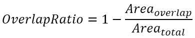
도 5는 연관값(AssocCost) 할당 행렬 설정 방법을 설명하기 위한 도면이다. 5 is a diagram for explaining a method of setting an association value (AssocCost) allocation matrix.
도 5를 참조하면, 연관값(AssocCost) 할당 행렬은 M개의 행과 N개의 열로 설정되고 각 기준 트랙(Ref Track)과 타겟 트랙(Target Track)의 순서쌍으로부터 산출된 연관값(AssocCost)이 배열된 행렬로 생성될 수 있다. 즉, 제1 행에는 제1 기준트랙(Ref Track 1)과 제1 내지 제N 타겟 트랙(Target Track 1~Target Track N)에 대해 산출된 연관값들(AssocCost11, AssocCost12,...AssocCost1N)이 저장되고, 제2 행에는 제2 기준트랙(Ref Track 2)과 제1 내지 제N 타겟 트랙(Target Track 1~Target Track N)에 대해 산출된 연관값들(AssocCost21, AssocCost22,...AssocCost2N)이 저장될 수 있다. 같은 방식으로 제M 행까지 제1 내지 제N 타겟 트랙(Target Track 1~Target Track N)에 대해 산출된 연관값들(AssocCostM1, AssocCostM2,...AssocCostMN)이 저장되어 ![]()
![]()
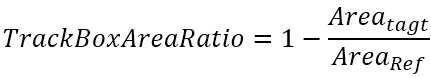
도 6은 도 2의 연관 센서 할당부(220)의 센서 할당 방법을 설명하기 위한 도면이다. 연관 센서 할당부(220)는 연관값(AssocCost) 할당 행렬에 할당 문제(assignment problem)의 최적해를 찾을 수 있는 알고리즘을 적용하여 최적의 연관 센서를 할당한다. 최적의 연관 센서는 기준 트랙과 센성 트랙 간의 유사도가 높은 센서의 조합을 의미할 수 있다.FIG. 6 is a diagram for explaining a sensor allocating method of the associated
할당 문제(assignment problem)의 최적해를 찾을 수 있는 알고리즘은 두 개의 그룹 간에 최대값 또는 최소값을 얻을 수 있는 최적의 순서쌍을 찾아내는 알고리즘이다. 실시예에 따른 연관 센서 할당부(220)는 연관값(AssocCost) 할당 행렬에 대해 연관값(AssocCost)을 최소화하는 최적의 기준 트랙과 타겟 트랙 쌍을 추출하는 알고리즘을 적용하여 최적의 센서 배열을 추출할 수 있다. 최적의 기준 트랙 및 타겟 트랙을 할당하는 방법으로는 주지의 기술이 적용될 수 있으며, 예컨대, 헝가리안 알고리즘(Hungarian algorithm)이 적용될 수 있다.An algorithm that can find the optimal solution of an assignment problem is an algorithm that finds the optimal ordered pair that can obtain the maximum or minimum value between two groups. The associated
헝가리안 알고리즘은 양의 정수로만 구성된 정방행렬에 적용되며, 다음의 4 단계로 수행된다는 점이 알려져 있다.It is known that the Hungarian algorithm is applied to a square matrix composed of only positive integers and is performed in the following four steps.
1 단계에서, 각 행(row)에서 가장 작은 값(minimum value)을 찾아, 해당 행(row)의 모든 값에서 빼준다.In
2 단계에서, 각 열(Colum)에서 가장 작은 값(minimum value)을 찾아, 해당 열(Colum)의 모든 값에서 빼준다.In
3 단계에서, 1, 2 단계가 끝난 후, 최소의 수평 라인 및 수직 라인을 사용하여 행렬에 포함된 0을 덮을 수 있도록 라인을 설정한다. 0을 덮는 라인의 수가 행 혹은 열의 개수와 동일하면, 0이 설정된 순서쌍이 최적으로 할당된 순서쌍으로 도출된다. 여기서, 0을 덮을 수 있도록 라인의 개수가 행 혹은 열의 개수보다 작을 경우 4 단계를 진행한다.In step 3, after
4 단계에서, 0을 덮는 라인을 제외한 나머지 라인에서 가장 작은 값(minimum value)을 찾아, 해당 라인의 모든 값을 빼준다. 이에 0이 추가로 생성되므로 0을 덮을 수 있는 라인을 하나 더 추가할 수 있다.In
이 후, 0을 덮는 라인의 수가 행 혹은 열의 개수와 동일해질 때까지 3 단계 및 4 단계를 반복하여 수행한 후, 추출되는 0이 설정된 순서쌍들을 최적으로 할당된 순서쌍으로 획득할 수 있다.Thereafter, steps 3 and 4 are repeatedly performed until the number of lines covering 0 is equal to the number of rows or columns, and then the extracted ordered pairs in which 0 is set can be obtained as optimally assigned ordered pairs.
연관 센서 할당부(220)는 이상의 헝가리안 알고리즘을 할당 알고리즘으로 적용하여 연관값(AssocCost) 할당 행렬에서 연관값(AssocCost)이 최적의 최소값을 갖도록 기준 트랙 및 타겟 트랙을 할당할 수 있다. 도 6을 참조하면, 연관 센서 할당부(220)의 할당 알고리즘 적용 결과, 음영으로 표시된 연관값(AssocCost)이 도출되는 기준 트랙 및 타겟 트랙의 조합이 연관값(AssocCost)을 최소값으로 도출할 수 있는 최적의 조합으로 추출될 수 있다.The associated
도 7은 도 2의 연관맵 생성부(230)의 연관맵(Association Map) 생성 방법을 설명하기 위한 도면이다.FIG. 7 is a diagram for explaining a method of generating an association map by the
연관맵 생성부(230)는 할당 알고리즘을 통해 할당된 다종의 센서 정보를 연관맵(Association Map)의 형태로 업데이트한다. 도 7에 도시된 바와 같이, 연관맵 생성부(230)는 제1 내지 M개의 기준 트랙(Ref Track 1~Ref Track M)에 대해 할당된 복수의 센서들(Sensor 1~Sensor N)의 정보(Index)를 연관맵(Association Map)의 형태로 업데이트할 수 있다.The association
이 후, 컨버전부(240)는 연관맵(Association Map)와 연관값(AssocCost)에 기초하여 센서 융합 결과를 출력한다.Thereafter, the
이를 위해, 컨버전부(240)는 연관맵(Association Map)와 연관값(AssocCost)을 이용하여 퓨전 트랙(fusion track)을 업데이트한다. 컨버전부(240)는 연관 센서들의 연관값(AssocCost)을 이용하여 각 센서 측정값의 가중치 팩터(Weighting factor)를 설정한다.To this end, the
컨버전부(240)는 선정된 가중치 팩터(Weighting factor)에 따라 퓨전 트랙(fusion track)의 물리값을 업데이트한다. 여기서 가중치 팩터(Weighting factor, W)는 다음의 [수학식 5]를 이용하여 산출될 수 있다.The

연관값(AssocCost)은 작은 값일 수록 높은 가중치(Weight)가 설정된다. 상기의 [수학식 5]은 연관값의 역수를 이용하여 산출되므로, 산출된 가중치 팩터(W)는 연관값(AssocCost)이 높은 순으로 할당된다.As the association value (AssocCost) has a smaller value, a higher weight is set. [Equation 5] is calculated using the reciprocal of the association value, so the calculated weight factor (W) is assigned in the order of highest association value (AssocCost).
컨버전부(240)는 퓨전 정보를 이용하여 직사각형 박스 형상으로 객체의 형상을 추정하여, 퓨전 트랙 정보를 생성할 수 있다. 이때, 직사각형 박스의 위치가 추정된 형상을 갖는 객체의 위치에 해당하고 직사각형 박스의 크기 즉, 폭(W) 및 길이(L)가 추정된 형상을 갖는 객체의 폭 및 길이에 각각 해당할 수 있다. 컨버전부(240)는 할당된 가중치(Weight)를 기준으로 퓨전 트랙의 물리값(위치, 속도, W/L 등)을 업데이트 하여 센서 융합 결과를 출력할 수 있다. 이를 수식으로 나타내면 다음의 [수학식 6]과 같이 나타낼 수 있다.The
이상과 같이, 실시예의 센서 정보 융합 장치(120)는 각 센서로부터 제1 내지 제 N 센서 트랙을 획득하여 기준트랙에 대한 센서 트랙의 연관값(AssocCost) 행렬을 생성하고, 각 센서별로 생성된 연관값 행렬들에 대해 할당 문제(assignment problem)의 최적해를 찾을 수 있는 알고리즘을 적용하여 최적의 연관 센서를 할당함으로써 복수의 센서의 결과를 하나의 연관맵(Association Map)으로 융합하여 센서 융합 결과를 출력할 수 있다. 이러한 센서 정보 융합 장치(120)의 제어 방법은 소프트웨어 로직으로 적용될 수 있으므로 추가적인 재료비 상승 없이도 센서 퓨전 융합 성능을 향상시킬 수 있다.As described above, the sensor information fusion device 120 of the embodiment obtains the first to Nth sensor tracks from each sensor, generates an association value (AssocCost) matrix of the sensor track with respect to the reference track, and associates the generated association for each sensor. By applying an algorithm that can find the optimal solution of the assignment problem to value matrices, by allocating the optimal association sensor, the results of multiple sensors are fused into one association map and the sensor fusion result is output. can do. Since the control method of the sensor information fusion device 120 can be applied as software logic, sensor fusion fusion performance can be improved without additional material cost increase.
도 8은 실시 예에 의한 센서 정보 융합 방법을 설명하기 위한 플로우차트이고, 도 9는 비교 예에 의한 센서 정보 융합 방법을 설명하기 위한 플로우차트이다.8 is a flowchart for explaining a sensor information fusion method according to an embodiment, and FIG. 9 is a flowchart for explaining a sensor information fusion method according to a comparative example.
도 8을 참조하면, 실시 예에 따른 센서 정보 융합 방법은 복수의 센서로부터 N개의 센서 트랙 정보를 획득한다(S110). 각 개별 센서는 제1 내지 제 N 센서 트랙을 출력할 수 있다.Referring to FIG. 8 , in the sensor information fusion method according to the embodiment, N sensor track information is acquired from a plurality of sensors (S110). Each individual sensor may output first through Nth sensor tracks.
제1 내지 제 M 기준 트랙에 대한 제1 내지 제 N 센서 트랙의 연관값(AssocCost)을 연산하여 ![]()
![]()
![]()
![]()
연관값 할당 행렬들에 대해 할당 문제(assignment problem)의 최적해를 찾을 수 있는 알고리즘을 적용하여 최적의 연관 센서를 할당한다(S130). 할당 문제의 최적해를 찾는 알고리즘으로는 헝가리안 알고리즘이 적용될 수 있다. 이에, 연관값(AssocCost) 할당 행렬에 대해 연관값(AssocCost)을 최소화하는 최적의 기준 트랙과 타겟 트랙 쌍을 매칭하여 최적의 센서 배열을 추출할 수 있다.An optimal association sensor is assigned by applying an algorithm capable of finding an optimal solution of an assignment problem to association value assignment matrices (S130). The Hungarian algorithm can be applied as an algorithm for finding an optimal solution to the assignment problem. Accordingly, an optimal sensor arrangement may be extracted by matching an optimal reference track and target track pair that minimizes the association value AssocCost with respect to the association value AssocCost allocation matrix.
추출된 연관 센서들을 하나의 연관맵(Association Map)으로 융합하여 연관맵을 업데이트한다(S140).The extracted association sensors are fused into one association map to update the association map (S140).
연관맵(Association Map)에 기초하여 연관된 센서 정보를 업데이트 한다(S150). 연관맵(Association Map)과 연관값을 이용하여 퓨전 트랙을 업데이트할 수 있다. 연관 센서들의 연관값 정보를 이용하여 각 센서 측정값의 가중치를 설정하고, 가중치에 따라 퓨전 트랙의 위치, 속도, 폭/길이 등의 물리값을 업데이트한 후, 센서 융합 결과를 출력한다(S160).Based on the association map, associated sensor information is updated (S150). A fusion track may be updated using an association map and an association value. The weight of each sensor measurement value is set using the associated value information of the related sensors, and the physical values such as the position, speed, width/length, etc. of the fusion track are updated according to the weighted value, and then the sensor fusion result is output (S160). .
이상의 실시예에 따르면, 센서 연관을 위한 연관값(AssocCost)을 산출함으로써, 입력 센서의 다양한 정보를 하나의 Cost 정보로 환산하여 비교할 수 있으므로, 최적 할당을 위한 지표로 사용할 수 있다. 실시예는 연관값(AssocCost)을 할당 행렬의 형태로 생성하고 최적 할당 알고리즘을 이용하여 센서 배열을 추출함으로써 시스템 전체의 센서 입력의 관점에서 최적의 배치를 추출할 수 있다. 또한, 실시예는 동일한 기준으로 계산된 연관값(AssocCost)을 기준으로 각 센서 측정치의 업데이트에 사용될 가중치를 적용할 수 있으므로 퓨전 트랙의 형상 정보 왜곡을 줄일 수 있다.According to the above embodiment, by calculating the association value (AssocCost) for sensor association, various information of the input sensor can be converted into one cost information and compared, so it can be used as an index for optimal allocation. The embodiment may extract an optimal arrangement in terms of sensor inputs of the entire system by generating the association value AssocCost in the form of an allocation matrix and extracting the sensor arrangement using an optimal allocation algorithm. In addition, since the embodiment can apply weights to be used for updating each sensor measurement value based on the association value (AssocCost) calculated on the same basis, distortion of shape information of the fusion track can be reduced.
도 9는 비교 예에 의한 센서 정보 융합 방법을 설명하기 위한 플로우차트이다.9 is a flowchart for explaining a sensor information fusion method according to a comparative example.
도 9를 참조하면, 비교 예에 의한 센서 정보 융합 방법은 단일 센서로부터 제1 내지 제 N 센서 트랙 정보를 획득한다(P110).Referring to FIG. 9 , in the sensor information fusion method according to the comparison example, first to Nth sensor track information is obtained from a single sensor (P110).
N개의 센서 트랙 정보 중 NN 게이트(NN Gate)를 통과한 센서 트랙 중 NN 트랙을 선정한다(P120). NN 게이트를 통과한 센서 트랙은 기준 트랙의 기준점을 중심으로 하는 게이트의 내부에 센서 트랙의 기준점이 위치하는 경우를 의미할 수 있다.Among the N sensor track information, a NN track is selected from sensor tracks that have passed through an NN gate (P120). The sensor track passing through the NN gate may refer to a case where the reference point of the sensor track is located inside the gate centered on the reference point of the reference track.
ID 게이트(ID Gate)를 통과한 센서 트랙을 선정한다(P130). ID 게이트를 통과한 센서 트랙은 이전 트랙의 ID가 유지되는 센서 트랙을 선정함을 의미한다.A sensor track that has passed through the ID gate is selected (P130). The sensor track that passed the ID gate means that a sensor track that maintains the ID of the previous track is selected.
ID 게이트를 통과한 센서 트랙을 우선 순위로 최종 연관 센서를 선정하고, 선정된 센서가 M개의 기준 센서와 NN 트랙인지를 확인한다(P140).The sensor tracks that have passed the ID gate are selected as the final related sensors in priority order, and it is confirmed whether the selected sensors are M reference sensors and NN tracks (P140).
선정된 최종 센서를 연관맵(Association Map)에 업데이트하고(P150), 연관맵에 기초하여 연관 센서의 정보를 취사 선택하여 퓨전 트랙을 업데이트한다(P160).The selected final sensor is updated in the association map (P150), and the fusion track is updated by selecting information of the association sensor based on the association map (P160).
이상과 같이, 비교 예에 의한 센서 정보 융합 방법은 각 기준 센서와의 최소거리를 기준으로 연관센서를 선정하고, ID 유지성을 추가 판단하여 최종 연관센서를 선정한다. 이러한 비교예의 방법은 각 기준센서 기준으로는 최적의 센서가 연관되지만, 각 센서 전체 출력을 기준으로 최적으로 할당이 되었는지는 확인할 수 없다는 문제점이 있다. 반면, 실시예에 의한 센서 정보 융합 방법은, 센서 연관을 위한 연관값(AssocCost)을 이용하여 할당 행렬을 생성함으로써 전체 트랙에 대한 연관을 한번에 수행할 수 있고, 최적 할당 알고리즘을 통해 시스템 전체의 최적 연관을 수행할 수 있다.As described above, in the sensor information fusion method according to the comparative example, a related sensor is selected based on a minimum distance from each reference sensor, and ID retention is additionally determined to select a final related sensor. In the method of this comparative example, although the optimum sensor is associated with each reference sensor standard, there is a problem in that it cannot be confirmed whether the sensor is optimally allocated based on the total output of each sensor. On the other hand, the sensor information fusion method according to the embodiment generates an allocation matrix using the association value (AssocCost) for sensor association, thereby performing association for all tracks at once, and optimizing the entire system through an optimal assignment algorithm. association can be made.
도 10은 실시 예와 비교 예에 따른 센서 정보 융합 결과를 대비하여 설명하기 위한 도면이다.10 is a diagram for explaining a comparison of sensor information fusion results according to an embodiment and a comparative example.
실제 객체(GT)에 대한 정보를 센싱하더라도 센서의 특성에 따라 제1 센서가 인식한 트랙(Sensor1 Track)과 제2 센서가 인식한 트랙(Sensor2 Track)의 형상은 다르게 인식될 수 있다.Even when information on the real object GT is sensed, the shape of the track recognized by the first sensor (Sensor1 Track) and the track recognized by the second sensor (Sensor2 Track) may be recognized differently according to the characteristics of the sensor.
비교예에 따른 센서 정보 융합 방법은 각 기준 센서와의 최소거리와 ID 유지성에 기초하여 정확하다고 생각되는 센서 정보를 선택하므로, 형상 정보의 연관선은 고려되지 않는다. 이에, 실제 트랙의 형상 정보(GT)와 센서 퓨전 트랙(Sensor Fusion Track)의 형상 정보 사이에 왜곡이 발생할 수 있다.Since the sensor information fusion method according to the comparative example selects sensor information that is considered accurate based on the minimum distance to each reference sensor and ID retention, the association line of shape information is not considered. Accordingly, distortion may occur between the shape information GT of the actual track and the shape information of the sensor fusion track.
반면, 실시예에 따른 센서 정보 융합 방법은 입력 센서의 다양한 정보들을 하나의 연관값(AssocCost)으로 환산하므로, 연관값(AssocCost)을 기준으로 각 센서 측정치의 업데이트에 사용될 가중치(Weighing Factor)를 설정할 수 있다. 가중치에 따라 센서 정보 융합 시 퓨전 트랙의 폭/길이 등의 형상 정보의 연관성이 반영될 수 있기 때문에, 퓨전 트랙의 형상 정보 왜곡을 줄일 수 있다.On the other hand, since the sensor information convergence method according to the embodiment converts various information of input sensors into one association value (AssocCost), a weight (Weighing Factor) to be used for updating each sensor measurement value is set based on the association value (AssocCost). can Depending on the weight, when sensor information is fused, correlation of shape information such as the width/length of the fusion track can be reflected, and thus distortion of shape information of the fusion track can be reduced.
이상에서 실시 예를 중심으로 설명하였으나 이는 단지 예시일 뿐 본 발명을 한정하는 것이 아니며, 본 발명이 속하는 분야의 통상의 지식을 가진 자라면 본 실시 예의 본질적인 특성을 벗어나지 않는 범위에서 이상에 예시되지 않은 여러 가지의 변형과 응용이 가능함을 알 수 있을 것이다. 예를 들어, 실시 예에 구체적으로 나타난 각 구성 요소는 변형하여 실시할 수 있는 것이다. 그리고 이러한 변형과 응용에 관계된 차이점들은 첨부된 청구 범위에서 규정하는 본 발명의 범위에 포함되는 것으로 해석되어야 할 것이다.Although the above has been described with reference to the embodiments, these are only examples and do not limit the present invention, and those skilled in the art to which the present invention belongs will not deviate from the essential characteristics of the present embodiment. It will be appreciated that various variations and applications are possible. For example, each component specifically shown in the embodiment can be modified and implemented. And differences related to these modifications and applications should be construed as being included in the scope of the present invention as defined in the appended claims.
Claims (19)
상기 행렬에 대해 상기 연관값을 최소화하는 기준 트랙 및 센서 트랙의 배열을 연산하여, 상기 복수의 센서에서 연산된 상기 기준 트랙 및 센서 트랙의 배열에 따라 상기 타겟에 대한 센싱 정보 융합 결과를 출력하는 단계;
를 포함하는 센서 정보 융합 방법.obtaining N sensor tracks from each of a plurality of sensors for targets located around the vehicle, calculating correlation values of the N sensor tracks with respect to M reference tracks, and storing them in a matrix form; and
Calculating an arrangement of reference tracks and sensor tracks that minimizes the correlation value with respect to the matrix, and outputting a sensing information fusion result for the target according to the arrangement of the reference tracks and sensor tracks calculated in the plurality of sensors. ;
Sensor information fusion method comprising a.
상기 연관값을 연산하여 행렬 형식으로 저장하는 단계는,
상기 기준 트랙 박스와 센서 트랙 박스 간의 거리, 상기 기준 트랙 박스와 센서 트랙 박스가 점유하는 전체 영역의 크기, 상기 기준 트랙 박스와 센서 트랙 박스의 중첩 영역의 크기 중 적어도 어느 하나에 기초하여 상기 연관값을 산출하는 단계를 포함하는 센서 정보 융합 방법.According to claim 1,
The step of calculating the association value and storing it in a matrix form,
The association value is based on at least one of the distance between the reference track box and the sensor track box, the size of the entire area occupied by the reference track box and the sensor track box, and the size of an overlapping area between the reference track box and the sensor track box. Sensor information fusion method comprising the step of calculating.
상기 연관값은,
상기 기준 트랙 박스와 상기 센서 트랙 박스 간 유사도가 높을 수록 작은 값으로 산출되는 센서 정보 융합 방법.According to claim 1,
The associated value is,
The sensor information fusion method of calculating a smaller value as the similarity between the reference track box and the sensor track box increases.
상기 타겟에 대한 센싱 정보 융합 결과를 출력하는 단계는,
상기 행렬에 대해 기 설정된 할당 알고리즘을 적용하여 상기 연관값을 최소화하는 기준 트랙 및 센서 트랙의 배열을 산출하는 단계를 포함하는 센서 정보 융합 방법.According to claim 1,
The step of outputting a result of fusion of sensing information for the target,
and calculating an arrangement of a reference track and a sensor track that minimizes the association value by applying a predetermined allocation algorithm to the matrix.
상기 타겟에 대한 센싱 정보 융합 결과를 출력하는 단계는,
상기 복수의 센서에서 산출된 상기 기준 트랙 및 센서 트랙의 배열을 상기 기준 트랙에 대한 상기 복수의 센서 정보가 저장된 연관맵(Association Map)에 업데이트하는 단계를 포함하는 센서 정보 융합 방법.According to claim 1,
The step of outputting a result of fusion of sensing information for the target,
and updating an arrangement of the reference tracks and sensor tracks calculated by the plurality of sensors in an association map in which information of the plurality of sensors for the reference tracks is stored.
상기 타겟에 대한 센싱 정보 융합 결과를 출력하는 단계는,
상기 연관맵(Association Map)과 상기 연관값에 기초하여 상기 복수의 센서의 상기 센서 트랙을 융합하여 생성되는 퓨전 트랙을 업데이트하는 단계를 포함하는 센서 정보 융합 방법.According to claim 5,
The step of outputting a result of fusion of sensing information for the target,
and updating a fusion track generated by fusing the sensor tracks of the plurality of sensors based on the association map and the association value.
상기 타겟에 대한 센싱 정보 융합 결과를 출력하는 단계는,
상기 연관값에 기초하여 상기 센서 측정값에 대해 가중치 팩터를 설정하는 단계; 및
상기 가중치 팩터에 따라 상기 퓨전 트랙의 위치, 속도, 폭/너비 중 적어도 어느 하나를 업데이트하는 단계;
를 포함하는 센서 정보 융합 방법.According to claim 6,
The step of outputting a result of fusion of sensing information for the target,
setting a weight factor for the sensor measurement value based on the association value; and
updating at least one of position, speed, and width/width of the fusion track according to the weight factor;
Sensor information fusion method comprising a.
상기 가중치 팩터는 다음의 수학식에 따라 산출되는 센서 정보 융합 방법.
[수학식]

W는 가중치 팩터, AssocCost는 연관값According to claim 6,
The weight factor is calculated according to the following equation.
[mathematical expression]
W is the weight factor, AssocCost is the associated value
상기 가중치 팩터를 설정하는 단계는,
상기 연관값이 작을 수록 가중치가 커지도록 상기 가중치 팩터를 설정하는 단계를 포함하는 센서 정보 융합 방법.According to claim 6,
The step of setting the weight factor,
and setting the weight factor so that the weight increases as the correlation value decreases.
차량 주변에 위치한 타겟에 대해 복수의 센서 각각으로부터 N 개의 센서 트랙을 획득하여 M 개의 기준 트랙에 대한 상기 N개의 센서 트랙의 연관값을 연산하여 행렬 형식으로 저장하는 기능; 및
상기 행렬에 대해 상기 연관값을 최소화하는 기준 트랙 및 센서 트랙의 배열을 연산하여, 상기 복수의 센서에서 연산된 상기 기준 트랙 및 센서 트랙의 배열에 따라 상기 타겟에 대한 센싱 정보 융합 결과를 출력하는 기능을 구현하는 프로그램을 기록한 컴퓨터로 읽을 수 있는 기록 매체.A recording medium on which a program for executing a sensor information fusion method is recorded,
a function of acquiring N sensor tracks from each of a plurality of sensors for targets located around the vehicle, calculating correlation values of the N sensor tracks with respect to M reference tracks, and storing them in a matrix form; and
A function of calculating an arrangement of reference tracks and sensor tracks that minimizes the correlation value with respect to the matrix, and outputting a sensing information fusion result for the target according to the arrangement of the reference tracks and sensor tracks calculated in the plurality of sensors. A computer-readable recording medium on which a program that implements is recorded.
차량 주변에 위치한 타겟에 대해 복수의 센서 각각으로부터 상기 N 개의 센서 트랙을 획득하여 M 개의 기준 트랙에 대한 상기 N개의 센서 트랙의 연관값을 연산하여 행렬 형식으로 저장하고, 상기 행렬에 대해 상기 연관값을 최소화하는 기준 트랙 및 센서 트랙의 배열을 연산하여, 상기 복수의 센서에서 연산된 상기 기준 트랙 및 센서 트랙의 배열에 따라 상기 타겟에 대한 센싱 정보 융합 결과를 출력하는 제어부;
를 포함하는 센서 정보 융합 장치.A sensor unit including a plurality of sensors for generating and outputting N sensor tracks based on object detection for targets located around the vehicle; and
The N sensor tracks are obtained from each of a plurality of sensors for targets located around the vehicle, and relation values of the N sensor tracks with respect to M reference tracks are calculated and stored in a matrix form, and the relation values for the matrix are calculated. a controller that calculates an array of reference tracks and sensor tracks that minimizes , and outputs a sensing information fusion result for the target according to the array of the reference tracks and sensor tracks calculated in the plurality of sensors;
Sensor information fusion device comprising a.
상기 제어부는,
상기 연관값을 연산하여 상기 행렬 형식으로 저장하는 연관값 행렬 생성부;
상기 행렬에 대해 기 설정된 할당 알고리즘을 적용하여 상기 연관값을 최소화하는 기준 트랙 및 센서 트랙의 배열을 산출하는 연관 센서 할당부;
상기 복수의 센서에서 산출된 상기 기준 트랙 및 센서 트랙의 배열에 따라 상기 복수의 센서의 센서 트랙을 융합하기 위한 연관맵을 생성하는 연관맵 생성부; 및
상기 연관맵 및 상기 연관값에 기초하여 상기 타겟에 대한 센싱 정보 융합 결과를 출력하는 컨버전부;
를 포함하는 센서 정보 융합 장치.According to claim 11,
The control unit,
a correlation value matrix generating unit that calculates the correlation values and stores them in the form of a matrix;
an association sensor allocator calculating an arrangement of reference tracks and sensor tracks that minimizes the association value by applying a preset assignment algorithm to the matrix;
a correlation map generating unit generating a correlation map for fusing the sensor tracks of the plurality of sensors according to the arrangement of the reference tracks and sensor tracks calculated by the plurality of sensors; and
a conversion unit outputting a fusion result of sensing information for the target based on the association map and the association value;
Sensor information fusion device comprising a.
상기 연관값 행렬 생성부는,
상기 기준 트랙 박스와 센서 트랙 박스 간의 거리, 상기 기준 트랙 박스와 센서 트랙 박스가 점유하는 전체 영역의 크기, 상기 기준 트랙 박스와 센서 트랙 박스의 중첩 영역의 크기 중 적어도 어느 하나에 기초하여 상기 연관값을 산출하는 센서 정보 융합 장치.According to claim 12,
The association value matrix generating unit,
The association value is based on at least one of the distance between the reference track box and the sensor track box, the size of the entire area occupied by the reference track box and the sensor track box, and the size of an overlapping area between the reference track box and the sensor track box. Sensor information fusion device that calculates.
상기 연관 센서 할당부는,
상기 행렬에 대해 헝가리안 알고리즘(Hungarian algorithm)을 적용하여 상기 기준 트랙 및 센서 트랙의 배열을 산출하는 센서 정보 융합 장치.According to claim 12,
The associated sensor allocation unit,
A sensor information fusion device for calculating an arrangement of the reference track and the sensor track by applying a Hungarian algorithm to the matrix.
상기 연관맵 생성부는,
상기 복수의 센서에서 산출된 상기 기준 트랙 및 센서 트랙의 배열을 상기 기준 트랙에 대한 상기 복수의 센서 정보가 저장된 연관맵(Association Map)에 업데이트하는 센서 정보 융합 장치.According to claim 12,
The association map generating unit,
Sensor information fusion device for updating the arrangement of the reference track and the sensor tracks calculated by the plurality of sensors to an association map in which information of the plurality of sensors for the reference track is stored.
상기 컨버전부는,
상기 연관맵(Association Map)과 상기 연관값에 기초하여 상기 복수의 센서의 상기 센서 트랙을 융합하여 생성되는 퓨전 트랙을 업데이트하는 센서 정보 융합 장치.According to claim 12,
The conversion unit,
A sensor information fusion device for updating a fusion track generated by fusing the sensor tracks of the plurality of sensors based on the association map and the association value.
상기 컨버전부는,
상기 연관값에 기초하여 상기 센서 측정값에 대해 가중치 팩터를 설정하고, 설정된 상기 가중치 팩터에 따라 상기 퓨전 트랙의 위치, 속도, 폭/너비 중 적어도 어느 하나를 업데이트하는 센서 정보 융합 장치.According to claim 16,
The conversion unit,
A sensor information fusion device for setting a weight factor for the sensor measurement value based on the association value, and updating at least one of position, speed, and width/width of the fusion track according to the set weight factor.
상기 가중치 팩터는 다음의 수학식에 따라 산출되는 센서 정보 융합 장치.
[수학식]

The weight factor is calculated according to the following equation.
[mathematical expression]
상기 가중치 팩터는, 상기 연관값이 작을 수록 가중치가 커지도록 설정되는 센서 정보 융합 장치.According to claim 17,
The weight factor is set such that a weight increases as the association value decreases.
Priority Applications (2)
| Application Number | Priority Date | Filing Date | Title |
|---|---|---|---|
| KR1020210093472A KR20230012780A (en) | 2021-07-16 | 2021-07-16 | Method and apparatus for fusing sensor information, and recording medium for recording program performing the method |
| US17/866,242 US12412380B2 (en) | 2021-07-16 | 2022-07-15 | Sensor information fusion method and device |
Applications Claiming Priority (1)
| Application Number | Priority Date | Filing Date | Title |
|---|---|---|---|
| KR1020210093472A KR20230012780A (en) | 2021-07-16 | 2021-07-16 | Method and apparatus for fusing sensor information, and recording medium for recording program performing the method |
Publications (1)
| Publication Number | Publication Date |
|---|---|
| KR20230012780A true KR20230012780A (en) | 2023-01-26 |
Family
ID=84890650
Family Applications (1)
| Application Number | Title | Priority Date | Filing Date |
|---|---|---|---|
| KR1020210093472A Pending KR20230012780A (en) | 2021-07-16 | 2021-07-16 | Method and apparatus for fusing sensor information, and recording medium for recording program performing the method |
Country Status (2)
| Country | Link |
|---|---|
| US (1) | US12412380B2 (en) |
| KR (1) | KR20230012780A (en) |
Families Citing this family (2)
| Publication number | Priority date | Publication date | Assignee | Title |
|---|---|---|---|---|
| US20250264612A1 (en) * | 2024-02-21 | 2025-08-21 | Nissan North America, Inc. | Track Based Moving Object Association for Distributed Sensing Applications |
| CN120802805B (en) * | 2025-09-09 | 2025-11-18 | 上海砺群科技有限公司 | Multi-layer algorithm fusion method, system and storage medium for controlling executor |
Family Cites Families (11)
| Publication number | Priority date | Publication date | Assignee | Title |
|---|---|---|---|---|
| US5482314A (en) | 1994-04-12 | 1996-01-09 | Aerojet General Corporation | Automotive occupant sensor system and method of operation by sensor fusion |
| US7991550B2 (en) | 2006-02-03 | 2011-08-02 | GM Global Technology Operations LLC | Method and apparatus for on-vehicle calibration and orientation of object-tracking systems |
| FR2960082B1 (en) | 2010-05-17 | 2012-08-10 | Commissariat Energie Atomique | METHOD AND SYSTEM FOR MERGING DATA FROM IMAGE SENSORS AND MOTION OR POSITION SENSORS |
| BR112013024112A2 (en) | 2011-04-04 | 2016-12-13 | Scania Cv Ab | road tilt estimation |
| US10268904B2 (en) | 2015-07-31 | 2019-04-23 | Magna Electronics Inc. | Vehicle vision system with object and lane fusion |
| US10630962B2 (en) * | 2017-01-04 | 2020-04-21 | Qualcomm Incorporated | Systems and methods for object location |
| US10466361B2 (en) | 2017-03-14 | 2019-11-05 | Toyota Research Institute, Inc. | Systems and methods for multi-sensor fusion using permutation matrix track association |
| KR102569900B1 (en) * | 2018-12-04 | 2023-08-23 | 현대자동차주식회사 | Apparatus and method for performing omnidirectional sensor-fusion and vehicle including the same |
| KR102151814B1 (en) | 2018-12-12 | 2020-09-03 | 충북대학교 산학협력단 | Method and Apparatus for Vehicle Detection Using Ladar Sensor and Camera |
| KR102569904B1 (en) * | 2018-12-18 | 2023-08-24 | 현대자동차주식회사 | Apparatus and method for tracking target vehicle and vehicle including the same |
| US10699563B1 (en) * | 2019-07-12 | 2020-06-30 | GM Global Technology Operations LLC | Multi-sensor multi-object tracking |
-
2021
- 2021-07-16 KR KR1020210093472A patent/KR20230012780A/en active Pending
-
2022
- 2022-07-15 US US17/866,242 patent/US12412380B2/en active Active
Also Published As
| Publication number | Publication date |
|---|---|
| US12412380B2 (en) | 2025-09-09 |
| US20230020920A1 (en) | 2023-01-19 |
Similar Documents
| Publication | Publication Date | Title |
|---|---|---|
| KR102529903B1 (en) | Apparatus and method for estimating position of vehicle | |
| JP6364049B2 (en) | Vehicle contour detection method, device, storage medium and computer program based on point cloud data | |
| CN110807350A (en) | System and method for visual SLAM for scan matching | |
| WO2018142900A1 (en) | Information processing device, data management device, data management system, method, and program | |
| KR20210135389A (en) | Apparatus for recognizing an obstacle, a vehicle system having the same and method thereof | |
| CN113658241B (en) | Monocular structured light depth recovery method, electronic device and storage medium | |
| CN110398726A (en) | Pick up calibration | |
| EP2840528A2 (en) | Method and apparatus for tracking object | |
| US10620752B2 (en) | System and method for predicting a touch position of a pointer on a touch-enabled unit or determining a pointing direction in 3D space | |
| KR102362470B1 (en) | Mehtod and apparatus for processing foot information | |
| KR20230012780A (en) | Method and apparatus for fusing sensor information, and recording medium for recording program performing the method | |
| CN107240104B (en) | Point cloud data segmentation method and terminal | |
| JP5960642B2 (en) | 3D information acquisition method and 3D information acquisition apparatus | |
| US20200258379A1 (en) | Determination of movement information with surroundings sensors | |
| CN113203424B (en) | Multi-sensor data fusion method and device and related equipment | |
| KR102325121B1 (en) | Real-time robot position estimation metod through map information and image matching and the robot | |
| US9773164B2 (en) | Apparatus and method for recognizing human body in hybrid manner | |
| KR102139667B1 (en) | Method and device for acquiring information | |
| JP2023107676A (en) | Information processing device, information processing method and program | |
| US20250074452A1 (en) | Method for locating specific autonomous vehicle and computing device using the same | |
| US12545286B2 (en) | Method for locating specific autonomous vehicle and computing device using the same | |
| JP2007316950A (en) | Image processing method, apparatus and program | |
| US12487354B2 (en) | Content capture of an environment of a vehicle using a priori confidence levels | |
| CN114078323A (en) | Perception enhancement method and device, road side base station, computer equipment and storage medium | |
| CN118463965B (en) | Positioning accuracy evaluation methods, devices, and vehicles |
Legal Events
| Date | Code | Title | Description |
|---|---|---|---|
| PA0109 | Patent application |
Patent event code: PA01091R01D Comment text: Patent Application Patent event date: 20210716 |
|
| PG1501 | Laying open of application | ||
| A201 | Request for examination | ||
| PA0201 | Request for examination |
Patent event code: PA02012R01D Patent event date: 20240619 Comment text: Request for Examination of Application Patent event code: PA02011R01I Patent event date: 20210716 Comment text: Patent Application |