KR20200047103A - Integrated Environment Monitoring Apparatus And the method thereof using Integrated Environment Monitoring Module - Google Patents
Integrated Environment Monitoring Apparatus And the method thereof using Integrated Environment Monitoring Module Download PDFInfo
- Publication number
- KR20200047103A KR20200047103A KR1020180129143A KR20180129143A KR20200047103A KR 20200047103 A KR20200047103 A KR 20200047103A KR 1020180129143 A KR1020180129143 A KR 1020180129143A KR 20180129143 A KR20180129143 A KR 20180129143A KR 20200047103 A KR20200047103 A KR 20200047103A
- Authority
- KR
- South Korea
- Prior art keywords
- monitoring
- information
- unit
- integrated
- environmental
- Prior art date
- Legal status (The legal status is an assumption and is not a legal conclusion. Google has not performed a legal analysis and makes no representation as to the accuracy of the status listed.)
- Granted
Links
Images


Classifications
-
- G—PHYSICS
- G06—COMPUTING OR CALCULATING; COUNTING
- G06Q—INFORMATION AND COMMUNICATION TECHNOLOGY [ICT] SPECIALLY ADAPTED FOR ADMINISTRATIVE, COMMERCIAL, FINANCIAL, MANAGERIAL OR SUPERVISORY PURPOSES; SYSTEMS OR METHODS SPECIALLY ADAPTED FOR ADMINISTRATIVE, COMMERCIAL, FINANCIAL, MANAGERIAL OR SUPERVISORY PURPOSES, NOT OTHERWISE PROVIDED FOR
- G06Q50/00—Information and communication technology [ICT] specially adapted for implementation of business processes of specific business sectors, e.g. utilities or tourism
- G06Q50/10—Services
- G06Q50/26—Government or public services
-
- G—PHYSICS
- G01—MEASURING; TESTING
- G01W—METEOROLOGY
- G01W1/00—Meteorology
- G01W1/02—Instruments for indicating weather conditions by measuring two or more variables, e.g. humidity, pressure, temperature, cloud cover or wind speed
- G01W1/06—Instruments for indicating weather conditions by measuring two or more variables, e.g. humidity, pressure, temperature, cloud cover or wind speed giving a combined indication of weather conditions
-
- G—PHYSICS
- G06—COMPUTING OR CALCULATING; COUNTING
- G06Q—INFORMATION AND COMMUNICATION TECHNOLOGY [ICT] SPECIALLY ADAPTED FOR ADMINISTRATIVE, COMMERCIAL, FINANCIAL, MANAGERIAL OR SUPERVISORY PURPOSES; SYSTEMS OR METHODS SPECIALLY ADAPTED FOR ADMINISTRATIVE, COMMERCIAL, FINANCIAL, MANAGERIAL OR SUPERVISORY PURPOSES, NOT OTHERWISE PROVIDED FOR
- G06Q50/00—Information and communication technology [ICT] specially adapted for implementation of business processes of specific business sectors, e.g. utilities or tourism
- G06Q50/10—Services
-
- Y—GENERAL TAGGING OF NEW TECHNOLOGICAL DEVELOPMENTS; GENERAL TAGGING OF CROSS-SECTIONAL TECHNOLOGIES SPANNING OVER SEVERAL SECTIONS OF THE IPC; TECHNICAL SUBJECTS COVERED BY FORMER USPC CROSS-REFERENCE ART COLLECTIONS [XRACs] AND DIGESTS
- Y02—TECHNOLOGIES OR APPLICATIONS FOR MITIGATION OR ADAPTATION AGAINST CLIMATE CHANGE
- Y02A—TECHNOLOGIES FOR ADAPTATION TO CLIMATE CHANGE
- Y02A90/00—Technologies having an indirect contribution to adaptation to climate change
- Y02A90/10—Information and communication technologies [ICT] supporting adaptation to climate change, e.g. for weather forecasting or climate simulation
Landscapes
- Business, Economics & Management (AREA)
- Tourism & Hospitality (AREA)
- Engineering & Computer Science (AREA)
- Strategic Management (AREA)
- General Business, Economics & Management (AREA)
- Economics (AREA)
- General Health & Medical Sciences (AREA)
- Human Resources & Organizations (AREA)
- Marketing (AREA)
- Primary Health Care (AREA)
- Environmental & Geological Engineering (AREA)
- Physics & Mathematics (AREA)
- Health & Medical Sciences (AREA)
- General Physics & Mathematics (AREA)
- Theoretical Computer Science (AREA)
- Development Economics (AREA)
- Educational Administration (AREA)
- Life Sciences & Earth Sciences (AREA)
- Atmospheric Sciences (AREA)
- Biodiversity & Conservation Biology (AREA)
- Ecology (AREA)
- Environmental Sciences (AREA)
- Air Conditioning Control Device (AREA)
Abstract
본 발명은 고정 환경 관측소에서 관측된 환경 정보와 불일치되는 지역에 대하여, 우선 모니터링 지역 선택, 모니터링 주기 설정 및 모니터링 대상의 환경 정보 선택을 수행한 후, 이동 또는 휴대 가능한 환경 통합 모니터링 모듈을 이용하여 선택 또는 설정된 조건에 따라 환경 통합 모니터링 대상 지역들에 대한 환경 통합 모니터링을 수행할 수 있도록 하는 환경 통합 모니터링 모듈을 이용한 환경 통합 모니터링 장치 및 그 방법에 관한 것이다.
본 발명의 일 실시예는, 환경 통합 모니터링 대상 지역들의 지도정보와 해당 지역의 장기의 환경 정보를 저장하는 데이터베이스부; 상기 데이터베이스부로부터 환경 통합 모니터링 대상 지역의 지도정보와 고정 관측소 측정 환경 정보를 기후예측모델에 적용하여 상기 환경 통합 모니터링 대상 지역 내의 분할한 단위 모니터링 지역들 각각에 대한 기후 예측 정보를 출력하는 기후예측부; 상기 기후 예측 정보와 상기 환경 통합 모니터링 대상 지역의 관측된 장기 환경 정보를 비교하여 기 설정된 비율 이상의 차이를 보이는 단위 모니터링 지역들을 우선 모니터링 지역으로 선정하는 우선 모니터링 지역 선정부; 및 환경 통합 모니터링 모듈을 구비하여 상기 우선 모니터링 지역의 우선순위별로 환경 통합 모니터링을 수행하는 환경 정보 측정부;를 포함하여 구성되는 환경 통합 모니터링 장치를 제공한다.The present invention first selects a monitoring area, sets a monitoring cycle, and selects environmental information of a monitoring target for an area inconsistent with environmental information observed in a stationary environment station, and then selects it using a mobile or portable environment integrated monitoring module Alternatively, the present invention relates to an integrated environmental monitoring device and method using an integrated environmental monitoring module that enables integrated environmental monitoring for environmentally integrated monitoring target areas according to a set condition.
According to an embodiment of the present invention, a database unit for storing map information of regions for integrated environmental monitoring and environmental information of a long-term region of the region; The climate prediction unit outputs climate prediction information for each of the divided unit monitoring areas in the environment integrated monitoring target area by applying map information of the environment-integrated monitoring target area and fixed station measurement environment information to the climate prediction model from the database unit. ; A priority monitoring area selection unit that compares the climate prediction information with the observed long-term environmental information of the environment-integrated monitoring target area and selects unit monitoring areas having a difference of a predetermined ratio or more as a priority monitoring area; And an environmental information measuring unit having an integrated environmental monitoring module and performing integrated environmental monitoring for each priority of the priority monitoring area.
Description
본 발명은 환경 통합 모니터링에 관한 것으로서, 고정 환경 관측소에서 관측된 환경 정보와 불일치되는 지역에 대하여, 우선 모니터링 지역 선택, 모니터링 주기 설정 및 모니터링 대상의 환경 정보 선택을 수행한 후, 이동 또는 휴대 가능한 환경 통합 모니터링 모듈을 이용하여 선택 또는 설정된 조건에 따라 환경 통합 모니터링 대상 지역들에 대한 환경 통합 모니터링을 수행할 수 있도록 하는 환경 통합 모니터링 모듈을 이용한 환경 통합 모니터링 장치 및 그 방법에 관한 것이다.The present invention relates to integrated environmental monitoring, for a region that is inconsistent with the environmental information observed in a stationary environmental station, first, after selecting a monitoring region, setting a monitoring cycle and selecting environmental information of a monitoring target, a mobile or portable environment The present invention relates to an integrated environmental monitoring device and method using the integrated environmental monitoring module, which enables environmental integrated monitoring for areas subject to environmental integrated monitoring according to selected or set conditions using the integrated monitoring module.
최근 기후변화로 인해 기온, 강우량 등 기상이 지역별로 편차가 심화되고 있으며 이상 현상의 발생 빈도 또한 증가하고 있어 종래기술의 고정된 관측소로는 이상 기후에 대처할 수 없는 문제점을 가진다.Due to recent climate change, weather, such as temperature and rainfall, has increased in each region, and the frequency of occurrence of anomalies is also increasing. Therefore, fixed stations of the prior art cannot cope with abnormal climates.
또한, 산업화의 부산물인 대기오염 물질을 비롯한 미세먼지에 의한 환경오염이 심각한 실정이다. 미세먼지는, 먼지(dust), 분진(Particulate), 에어로졸(Aerosol), 훈연(Fume), 검댕(Soot) 등 가스 상태의 매체에 부유하고 있는 고체나 액체 상태의 물질 또는 물질의 파쇄, 선별, 퇴적 등 기계적 처리 또는 연소, 합성, 분해 시 발생하는 고체상 또는 액체상의 미세한 물질이다. 입경 10μm 이하의 입자상 물질은 PM10이라 하고, 입경 2.5μm 이하인 입자상 물질은 PM2.5라고 하며 초미세먼지라고 한다. 이러한 미세 먼지 또한 지속적으로 발생이 증가하여 국민의 건강에 영향을 미치고 있는 실정이므로, 대기 중 미세먼지의 오염 정도를 조기에 관측하여 대처 해야할 필요성이 높다. In addition, environmental pollution caused by fine dust, including air pollutants, a by-product of industrialization, is a serious situation. Fine dust, crushing, screening of solid or liquid substances or substances suspended in gaseous media such as dust, particulate, aerosol, fume, soot, etc. It is a fine material in the solid or liquid phase that occurs during mechanical treatment such as sedimentation or combustion, synthesis, and decomposition. Particulate matter having a particle diameter of 10 μm or less is called PM10, and particulate matter having a particle diameter of 2.5 μm or less is called PM2.5 and is called ultrafine dust. Since such fine dust also continuously increases and affects people's health, there is a high need to observe and deal with the pollution level of fine dust in the air early.
이에 따라, 대기 중의 환경 정보를 수집하고 수집된 데이터를 분석하여 예측 및 선제적 대응 방안을 제시하기 위해서는 고해상도의 환경 모니터링이 반드시 요구된다.Accordingly, in order to collect environmental information in the atmosphere and analyze the collected data to present a predictive and preemptive countermeasure, high-resolution environmental monitoring is essential.
이러한 요구에 부응하여 대한민국 등록특허 제1456524호는 계측기, 레이더 강우 데이터와 빅데이터 처리 기술을 접목한 강우 정보 시스템 및 강우 정보 서버를 개시한다.In response to this request, Korean Patent Registration No. 1456524 discloses a rainfall information system and a rainfall information server that combines a radar rainfall data with a big data processing technology.
그러나 상술한 종래기술들의 경우 인력 여건 및 운용비용에 따른 제약사항으로 인해 설치 밀도가 낮은 고정된 관측소의 관측값들을 이용하게 되므로, 불균일한 공간 분포와 불균일한 관측밀도에 의해 넓은 범위의 영역에 대한 균일한 환경 통합 모니터링을 수행하지 못하게 되고, 이로 인해, 측정된 환경 정보가 환경 모니터링 대상 지역 내부의 국지 영역의 실제 환경 정보와 불일치를 나타내게 되어 관측된 환경 정보의 시공간적 해상도가 저하되는 한계를 가진다.However, in the case of the above-mentioned conventional technologies, observations from a fixed station with a low installation density are used due to constraints due to manpower conditions and operating costs, so that a wide range of areas can be caused by non-uniform spatial distribution and non-uniform observation density. It is not possible to perform uniform environment integrated monitoring, and as a result, the measured environmental information is inconsistent with the actual environmental information of the local area inside the environment monitoring target area, and thus has a limitation that the spatial and temporal resolution of the observed environmental information is deteriorated.
또한, 종래기술의 고정된 관측소들로 구성된 환경 모니터링 네트워크를 이용하여 수집된 환경 정보들은 국토교통부, 환경부, 한국환경공단 등 조사 분석 기관에 따라 결과가 상이하여 환경에 적절하게 대처하기가 용이하지 않은 문제점을 가진다.In addition, the environmental information collected using the environmental monitoring network composed of fixed stations of the prior art has different results depending on the research and analysis organizations such as the Ministry of Land, Infrastructure and Transport, the Ministry of Environment, and the Korea Environmental Agency, and it is not easy to properly deal with the environment. Has a problem
또한, 종래기술의 고정된 관측소들로 구성된 환경 모니터링 네트워크의 문제점을 보완하고자 이동하며 환경 정보를 관측하는 경우 사용자의 경험과 주관적 판단으로 모니터링 지역 및 모니터링 주기를 결정하게 되므로 체계적인 환경 모니터링을 수행하지 못하는 문제점을 가진다.In addition, when attempting to compensate for the problem of the environmental monitoring network composed of fixed stations of the prior art, and observing environmental information, it is impossible to perform systematic environmental monitoring because it determines the monitoring area and monitoring cycle based on user experience and subjective judgment. Has a problem
따라서 상술한 종래기술의 문제점을 해결하기 위한 본 발명의 일 실시예는, 외부의 추가적인 유입유량에 의한 영향을 제거하기 위한 장치와 이를 포함하는 통합 모니터링 장치를 포함하여 구성되는 환경 통합 모니터링 모듈을 휴대 또는 이동체에 탑재한 후, 고정 관측소에서 관측된 환경 정보를 적용할 수 없는 지역들에 대하여, 우선 모니터링 지역 선택, 모니터링 주기 설정 및 모니터링 대상의 환경 정보 선택을 수행한 후, 선택된 또는 설정된 조건에 따라 환경 통합 모니터링을 수행할 수 있도록 하는 환경 통합 모니터링 모듈을 이용한 환경 통합 모니터링 장치 및 그 방법을 제공하는 것을 목적으로 한다.Therefore, an embodiment of the present invention for solving the above-described problems of the prior art is carried by the environment integrated monitoring module comprising a device for removing the influence of the additional inlet flow from the outside and an integrated monitoring device including the same Or, after mounting on a moving object, for areas where environmental information observed in a fixed station cannot be applied, first select the monitoring area, set the monitoring cycle and select the environmental information of the monitored object, and then, depending on the selected or set conditions. It is an object of the present invention to provide an integrated environmental monitoring device and method using an integrated environmental monitoring module that enables integrated environmental monitoring.
상술한 본 발명의 과제를 달성하기 위한 본 발명의 일 실시예는, 환경 통합 모니터링 대상 지역들의 지도정보와 해당 지역의 장기의 환경 정보를 저장하는 데이터베이스부; 상기 데이터베이스부로부터 환경 통합 모니터링 대상 지역의 지도정보와 고정 관측소 측정 환경 정보를 기후예측모델에 적용하여 상기 환경 통합 모니터링 대상 지역 내의 분할한 단위 모니터링 지역들 각각에 대한 기후 예측 정보를 출력하는 기후예측부; 상기 기후 예측 정보와 상기 환경 통합 모니터링 대상 지역의 관측된 장기 환경 정보를 비교하여 기 설정된 비율 이상의 차이를 보이는 단위 모니터링 지역들을 우선 모니터링 지역으로 선정하는 우선 모니터링 지역 선정부; 및 환경 통합 모니터링 모듈을 구비하여 상기 우선 모니터링 지역의 우선순위별로 환경 통합 모니터링을 수행하는 환경 정보 측정부;를 포함하여 구성되는 환경 통합 모니터링 장치를 제공한다.One embodiment of the present invention for achieving the above-described problems of the present invention, the database unit for storing the map information of the environment integrated monitoring target area and environmental information of the long-term of the area; The climate prediction unit outputs climate prediction information for each of the divided unit monitoring areas in the environment integrated monitoring target area by applying map information of the environment-integrated monitoring target area and fixed station measurement environment information to the climate prediction model from the database unit. ; A priority monitoring area selection unit that compares the climate prediction information with the observed long-term environmental information of the environment-integrated monitoring target area and selects unit monitoring areas having a difference of a predetermined ratio or more as a priority monitoring area; And an environmental information measuring unit having an integrated environmental monitoring module and performing integrated environmental monitoring for each priority of the priority monitoring area.
본 발명의 일 실시예의 상기 지도정보는, 도로망 정보, 주거, 산업 또는 농업 지역 정보 중 하나 이상을 포함하는 토지피복도 정보 중 하나 이상을 포함할 수 있다.The map information of an embodiment of the present invention may include one or more of road covering information, including one or more of road network information, residential, industrial or agricultural area information.
본 발명의 일 실시예의 상기 환경 통합 모니터링 대상 환경 정보는, 미세먼지, 기온, 습도, 강우 또는 풍향 정보 중 하나 이상을 포함할 수 있다.The environment-integrated monitoring target environment information of one embodiment of the present invention may include one or more of fine dust, temperature, humidity, rainfall, or wind direction information.
본 발명의 일 실시예의 상기 데이터베이스부에 저장되는 환경 통합 모니터링 대상 지역에 대한 장기의 환경 정보는, 기 설정된 기간 동안의 기 설정된 시간별로 측정된 기온, 온도, 습도, 강우 또는 풍향 중 하나 이상의 정보를 포함할 수 있다.The long-term environmental information for the environment-integrated monitoring target area stored in the database unit according to an embodiment of the present invention includes information on one or more of temperature, temperature, humidity, rainfall, or wind direction measured for each preset time during a preset period. It can contain.
본 발명의 일 실시예의 상기 우선 모니터링 지역 선정부에 의해 비교되는 정보 중, 상기 기후 예측 정보는 상기 장기 환경 정보 저장 기간 동안 예측된 기온, 습도, 풍향 또는 강우 중 하나 이상의 평균 값이고, 상기 장기 환경 정보는 상기 환경 통합 모니터링 대상 지역 전체의 장기 저장된 기온, 습도, 풍향 또는 강우 중 하나 이상의 평균 값일 수 있다.Among the information compared by the priority monitoring area selection unit of an embodiment of the present invention, the climate prediction information is an average value of at least one of temperature, humidity, wind direction or rainfall predicted during the long-term environment information storage period, and the long-term environment The information may be an average value of at least one of temperature, humidity, wind direction, or rainfall stored for a long time in the entire area to be monitored for the environment.
본 발명의 일 실시예의 상기 환경 정보 측정부는, 미세먼지의 측정 시, 측정된 습도가 강우 습도 이하인 경우와, 측정된 강우가 미세먼지 유무에 영향을 주는 유효 강우 이하인 경우 미세먼지를 선택적으로 측정하도록 구성될 수 있다.The environmental information measuring unit of an embodiment of the present invention, when measuring fine dust, when the measured humidity is less than the rainfall humidity, and when the measured rainfall is less than the effective rainfall affecting the presence or absence of fine dust to selectively measure fine dust Can be configured.
본 발명의 일 실시예의 상기 환경 통합 모니터링 장치는, 모니터링 대상 환경 정보 또는 측정 중 이동 속도에 따라 모니터링 주기를 설정하는 모니터링 주기 결정부;를 더 포함하여 구성될 수 있다.The environment-integrated monitoring apparatus according to an embodiment of the present invention may further include a monitoring cycle determining unit for setting a monitoring cycle according to the monitoring target environment information or a moving speed during measurement.
본 발명의 일 실시예의 상기 환경 통합 모니터링 모듈은, 상기 이동체의 이동 방향측의 전면에 형성되는 관형의 유입관과, 상기 유입관의 하류측 단면으로부터 확장되며 외주면에 배치되는 하나 이상의 보조유입구멍이 형성되는 확장관 및 상기 확장관의 단부의 직경을 가지고 연장 형성되어 내부에 측정 대상 공기의 흐름을 형성하고, 상기 환경 통합 모니터링부가 설치되는 측정관을 포함하여, 외부의 공기를 유입 받은 후 통합 환경 모니터링을 위한 유속으로 변환하여 배출하는 것에 의해 내부에 측정 대상 공기의 흐름을 형성하는 관측관; 및 상기 관측관의 내부에 설치되어 상기 측정 대상공기의 상태를 검출하여 통합 환경 모니터링 정보를 생성한 후 원격지로 전송하는 환경 통합 모니터링부;를 포함하여, 휴대 또는 이동체에 탑재되어 이동되며 고정된 관측소에 의해 측정된 값을 적용할 수 없는 미계측 지역의 환경에 대한 통합 모니터링을 수행할 수 있도록 하는 것을 특징으로 한다.The environment-integrated monitoring module of an embodiment of the present invention includes a tubular inlet pipe formed on a front surface of a moving direction side of the moving body, and at least one auxiliary inlet hole extending from a downstream end face of the inlet pipe and disposed on an outer circumferential surface The expansion pipe formed and the diameter of the end portion of the expansion pipe is extended to form a flow of air to be measured therein, and includes an environment in which the environment integrated monitoring unit is installed. Observation tube to form a flow of air to be measured therein by converting to a flow rate for monitoring and discharge; And an integrated environment monitoring unit installed inside the observation tube to detect the state of the measurement target air, generate integrated environment monitoring information, and transmit it to a remote site. It is characterized in that it is possible to perform integrated monitoring of the environment in the unmeasured area where the value measured by is not applicable.
본 발명의 일 실시예의 상기 상기 환경 통합 모니터링부는, 상기 측정관 내부의 상기 측정 대상 공기의 유속을 검출하는 유속감지부; 상기 측정 대상 공기에 포함되는 미세먼지를 검출하는 미세먼지센서부; 상기 측정 대상 공기의 습도, 온도, 강우 또는 풍향 중 하나 이상을 검출하여 기상정보를 생성하는 기상측정센서부; 환경 통합 모니터링 되는 위치 정보를 생성하는 GPS모듈; 상기 미세먼지센서부와 상기 기상측정센서부에서 측정된 미세먼지검출 신호와 기상측정신호를 입력받은 후 연산처리를 수행하여 측정 지역의 미세먼지정보와 기상정보를 생성하여 출력하는 제어부; 및 상기 제어부에서 출력된 미세먼지정보와 기상정보를 외부로 전송하는 데이터 전송부;를 포함하여 구성될 수 있다.The integrated environment monitoring unit of an embodiment of the present invention, a flow rate detection unit for detecting the flow rate of the measurement target air inside the measurement tube; A fine dust sensor unit for detecting fine dust contained in the measurement target air; A weather measurement sensor unit for generating weather information by detecting one or more of humidity, temperature, rainfall or wind direction of the measurement target air; GPS module for generating location information to be monitored in an integrated environment; A control unit for generating and outputting fine dust information and weather information of a measurement area by performing a calculation process after receiving the fine dust detection signal and the weather measurement signal measured by the fine dust sensor unit and the weather measurement sensor unit; And a data transmission unit for transmitting fine dust information and weather information output from the control unit to the outside.
본 발명의 일 실시예의 상기 미세먼지센서부는, 상기 유속감지부로부터 입력되는 측정 대상 공기의 유속에 상기 펌프부의 공기 흡입부의 단면적을 곱하여 유량으로 환산하여 전체 흡입 유량을 검출한 후, 정지 상태에서의 흡입 유량(Q0)이 되도록 흡입출력을 제어하는 것에 의해 이동체의 이동에 의해 추가된 유량(Qa)을 제거하는 흡입유량 보정을 수행하여 기 설정된 흡입 유량을 가지도록 상기 측정 대상공기를 흡입하는 펌프부; 상기 펌프부를 통해 유입된 측정 대상 공기에 빛을 조사한 후 산란되는 빛의세기를 검출하는 산란감지부; 및 상기 산란감지부에서 검출된 산란되는 빛의 세기 신호에 대한 연산을 수행하여 상기 측정 대상 공기에 포함되는 미세먼지의 크기 또는 농도 값을 산출하여 상기 제어부로 출력하는 계산처리부;를 포함하여 구성될 수 있다.The fine dust sensor unit according to an embodiment of the present invention multiplies the flow rate of air to be measured inputted from the flow rate sensing unit by the cross-sectional area of the air suction unit of the pump unit, converts it into a flow rate, detects the total suction flow rate, and then stops Inhaling the measured target air so as to have a preset suction flow by performing a suction flow correction to remove the added flow (Q a ) by the movement of the moving object by controlling the suction output to be the suction flow (Q 0 ). Pump part; A scattering detection unit that detects the intensity of light scattered by irradiating light to the measurement target air introduced through the pump unit; And a calculation processing unit that calculates the size or concentration value of fine dust contained in the measurement target air by performing an operation on the scattered light intensity signal detected by the scattering detection unit and outputs it to the control unit. You can.
상술한 목적을 달성하기 위한 본 발명의 다른 실시예는, 장기 환경 정보와 지도정보를 저장하는 데이터베이스부, 기후예측부, 우선 모니터링 지역 선정부, 모니터링 주기 결정부 및 환경 정보 측정부를 구비한 환경 통합 모터링 장치에 의한 환경 통합 모니터링 방법에 있어서, 상기 기후예측부가 환경 통합 모니터링 대상 지역을 일정 영역으로 분할한 단위 모니터링 지역들 각각에 대한 기후 예측 정보를 생성하는 단위 모니터링 지역별 기후 예측 단계; 상기 우선 모니터링 지역 선정부가 상기 단위 모니터링 지역별 기후 예측 정보와 상기 데이터베이스부에 저장된 상기 환경 통합 모니터링 대상 지역 전체의 환경 정보를 비교하여, 차이의 비율이 일정 값 이상인 단위 모니터링 지역들을 우선 모니터링 지역들로 선정하는 우선 모니터링 지역 선정 단계; 상기 모니터링 주기 결정부가 측정 대상 환경 정보와 측정을 위한 이동 속도를 기준으로 모니터링 주기를 결정하는 모니터링 주기 결정 단계; 및 상기 환경 정보 측정부가 상기 결정된 모니터링 주기 및 상기 우선 모니터링 지역의 우선순위별로 선택적인 환경 통합 모니터링을 수행하는 선택적 환경 정보 측정 단계;를 포함하는 환경 통합 모니터링 방법을 제공한다.Another embodiment of the present invention for achieving the above object is, a database unit for storing long-term environmental information and map information, climate prediction unit, priority monitoring area selection unit, monitoring cycle determining unit and environmental information measurement unit integrated environment A method for integrated environmental monitoring by a motoring device, comprising: a climate prediction step for each unit monitoring region, wherein the climate prediction unit generates climate prediction information for each of the unit monitoring regions where the environment integrated monitoring target region is divided into a predetermined region; The priority monitoring area selection unit compares climate prediction information for each unit monitoring area with environmental information for the entire environment-monitored area stored in the database unit, and selects unit monitoring areas having a difference ratio equal to or greater than a predetermined value as priority monitoring areas Priority monitoring area selection step; A monitoring period determination step in which the monitoring period determination unit determines a monitoring period based on the measurement target environment information and a moving speed for measurement; And an optional environmental information measurement step in which the environmental information measurement unit performs selective environmental integrated monitoring according to the determined monitoring cycle and priority of the priority monitoring area.
본 발명의 다른 실시예의 상기 지도정보는, 위도와 경도 정보, 도로망 정보, 주거, 산업 또는 농업 지역 정보 중 하나 이상을 포함하는 토지피복도 정보 중 하나 이상을 포함할 수 있다.The map information of another embodiment of the present invention may include one or more of land cover information including one or more of latitude and longitude information, road network information, residential, industrial or agricultural area information.
본 발명의 다른 실시예의 상기 환경 통합 모니터링 대상 환경 정보는, 미세먼지, 기온, 습도, 강우 또는 풍향 정보 중 하나 이상을 포함할 수 있다.The environment-integrated monitoring target environment information of another embodiment of the present invention may include one or more of fine dust, temperature, humidity, rainfall, or wind direction information.
본 발명의 다른 실시예의 상기 우선 모니터링 지역 설정 단계에서 비교되는 정보 중, 상기 기후 예측 정보는 상기 장기 환경 정보 저장 기간 동안 예측된 기온, 습도, 풍향 또는 강우 중 하나 이상의 평균 값이고, 상기 장기 환경 정보는 상기 환경 통합 모니터링 대상 지역 전체의 장기 저장된 기온, 습도, 풍향 또는 강우 중 하나 이상의 평균 값일 수 있다.Among the information compared in the priority monitoring area setting step of another embodiment of the present invention, the climate prediction information is an average value of at least one of temperature, humidity, wind direction or rainfall predicted during the long-term environment information storage period, and the long-term environment information May be an average value of at least one of temperature, humidity, wind direction, or rainfall stored for a long time in the entire area to be monitored.
본 발명의 다른 실시예의 상기 선택적 환경 측정 정보 측정 단계는, 미세먼지 측정 시, 측정된 습도가 강우 습도 이하인 경우와, 측정된 강우가 미세먼지 유무에 영향을 주는 유효 강우 이하인 경우 미세먼지를 선택적으로 측정하도록 구성될 수 있다In the optional environmental measurement information measurement step of another embodiment of the present invention, when measuring fine dust, when the measured humidity is equal to or less than the rainfall humidity, and when the measured rainfall is equal to or less than the effective rainfall affecting the presence or absence of fine dust, fine dust is selectively selected. Can be configured to measure
본 발명의 실시예들에 따르면, 고정 관측소에서 관측된 환경 정보를 적용할 수 없는 지역들에 대하여, 우선 모니터링 지역 선택, 모니터링 주기 설정 및 모니터링 대상의 환경 정보 선택을 수행한 후, 선택 또는 설정된 조건에 따라 이동한 후 정지 중에 또는 이동하며 환경 통합 모니터링을 수행할 수 있도록 하는 것에 의해, 저비용으로 많은 지점의 환경 정보를 수집할 수 있도록 하여, 관측 지점의 밀도를 높이고 균일한 분포를 가지도록 함으로써, 관측된 환경 정보의 시공간적 해상도를 현저히 향상시키는 효과를 제공한다.According to embodiments of the present invention, for areas where environmental information observed in a fixed station cannot be applied, first, a monitoring area is selected, a monitoring period is set, and environmental information of a monitoring object is selected, and then selected or set conditions By making it possible to collect environmental information at many points at a low cost by making it possible to perform integrated environmental monitoring while moving or in motion after stopping, thereby increasing the density of observation points and having a uniform distribution, It provides the effect of significantly improving the spatial and temporal resolution of the observed environmental information.
또한, 본 발명의 실시예들에 따르면, 모니터링 대상 지역의 수집된 환경에 대한 현황파악 시, 환경 정보의 데이터 분석 또는 예보 모델을 통한 예측 시 요구되는 특정 지점의 환경 정보를 용이하게 수집할 수 있도록 하는 효과를 제공한다.In addition, according to embodiments of the present invention, when grasping the current status of the collected environment in the monitoring target area, it is possible to easily collect environment information at a specific point required for data analysis of environment information or prediction through a forecast model. Provides the effect.
또한, 본 발명의 실시예들에 따르면, 원하는 시점에 특정 기간 동안의 데이터가 요구되는 필요 지점의 정보를 직접적으로 수집할 수 있도록 함으로써, 효율적인 환경 통합 모니터링을 수행할 수 있도록 하는 효과를 제공한다.In addition, according to embodiments of the present invention, it is possible to directly collect information on a required point at which data for a specific period is desired at a desired time point, thereby providing an effect of performing effective environmental integrated monitoring.
도 1은 본 발명의 일 실시예의 환경 통합 모니터링 장치(1)의 기능 블록도.
도 2는 본 발명의 일 실시예의 환경 통합 모니터링 모듈(M)의 사시도.
도 3은 본 발명의 일 실시예의 환경 통합 모니터링 모듈(M)의 단면도 및 관측관 내부의 측정 대상 공기의 유속을 나타내는 도면.
도 4는 본 발명의 일 실시예의 환경모니터링부(200)의 기능 블록 구성도.
도 5는 본 발명의 일 실시예의 미세먼지센서부(220)의 이동 시의 미세 먼지 측정 오차를 나타내는 도면.
도 6은 본 발명의 다른 실시예의 환경 통합 모니터링 방법의 처리과정을 나타내는 순서도.
도 7은 우선 모니터링 지역 선정을 위한 관측소에서 측정된 환경 정보로서의 기온과 단위 모니터링 지역들의 예측된 환경 정보로서의 기온의 유사도를 나타내는 그래프이다.
도 8은 기온 모니터링 부재 지역을 나타내는 도면.
도 9는 강수량 모니터링 부재 지역을 나타내는 도면.
도 10은 단위 모니터링 지역들에 대한 기후예측부(20)에 의해 예측된 기온 값에 대한 고정 관측소에서 측정된 기온 값의 유사도가 60% 이하인 지역들이 97% 포함된 경우를 나타내는 유사도 판단도면.
도 11은 단위 모니터링 지역들에 대한 기후예측부(20)에 의해 예측된 강수량에 대한 고정 관측소에서 측정된 강수량 값의 유사도 2% 이하 지역이 99% 포함된 경우를 나타내는 유사도 판단도면.
도 12는 토지피복도를 나타내는 도면.
도 13은 토지피복도 범례의 표를 나타내는 도면.
도 14는 본 발명의 실시예의 선택적 환경 데이터 취득 단계(S40)의 상세 처리과정을 나타내는 환경 통합 모니터링 방법의 처리과정을 나타내는 순서도.1 is a functional block diagram of an environment-integrated
2 is a perspective view of an integrated environment monitoring module (M) of an embodiment of the present invention.
3 is a cross-sectional view of an integrated environment monitoring module (M) of one embodiment of the present invention and a view showing the flow velocity of the measurement target air inside the observation tube.
4 is a functional block diagram of an
5 is a view showing a fine dust measurement error when moving the fine
Figure 6 is a flow chart showing the process of the integrated environmental monitoring method of another embodiment of the present invention.
7 is a graph showing the similarity between air temperature as environmental information measured at an observatory for selecting a monitoring area and air temperature as predicted environmental information of unit monitoring areas.
8 is a view showing an area without temperature monitoring.
9 is a view showing an area without precipitation monitoring.
FIG. 10 is a similarity determination diagram showing a case where 97% of regions having a similarity of a temperature value of 60% or less measured at a fixed station for a temperature value predicted by the
11 is a similarity judgment drawing showing a case where 99% of regions having a similarity of 2% or less of the precipitation value measured at a fixed station for precipitation predicted by the
12 is a view showing a land covering degree.
13 is a diagram showing a table of land cover legends.
Figure 14 is a flow chart showing the processing of the integrated environmental monitoring method showing the detailed processing of the optional environmental data acquisition step (S40) of the embodiment of the present invention.
이하에서는 첨부한 도면을 참고하여 본 발명을 설명하기로 한다. 그러나 본 발명은 여러 가지 상이한 형태로 구현될 수 있으며, 따라서 여기에서 설명하는 실시예로 한정되는 것은 아니다. 그리고 도면에서 본 발명을 명확하게 설명하기 위해서 설명과 관계없는 부분은 생략하였으며, 명세서 전체를 통하여 유사한 부분에 대해서는 유사한 도면 부호를 붙였다.Hereinafter, the present invention will be described with reference to the accompanying drawings. However, the present invention may be implemented in various different forms, and thus is not limited to the embodiments described herein. In addition, in order to clearly describe the present invention in the drawings, parts irrelevant to the description are omitted, and like reference numerals are assigned to similar parts throughout the specification.
명세서 전체에서, 어떤 부분이 다른 부분과 "연결(접속, 접촉, 결합)"되어 있다고 할 때, 이는 "직접적으로 연결"되어 있는 경우뿐 아니라, 그 중간에 다른 부재를 사이에 두고 "간접적으로 연결"되어 있는 경우도 포함한다. 또한 어떤 부분이 어떤 구성요소를 "포함"한다고 할 때, 이는 특별히 반대되는 기재가 없는 한 다른 구성요소를 제외하는 것이 아니라 다른 구성요소를 더 구비할 수 있다는 것을 의미한다.Throughout the specification, when a part is "connected (connected, contacted, coupled)" to another part, this is not only when it is "directly connected", but also "indirectly" with another member in between. "It also includes the case where it is. Also, when a part is said to “include” a certain component, this means that other components may be further provided instead of excluding the other component unless otherwise stated.
본 명세서에서 사용한 용어는 단지 특정한 실시예를 설명하기 위해 사용된 것으로, 본 발명을 한정하려는 의도가 아니다. 단수의 표현은 문맥상 명백하게 다르게 뜻하지 않는 한, 복수의 표현을 포함한다. 본 명세서에서, "포함하다" 또는 "가지다" 등의 용어는 명세서상에 기재된 특징, 숫자, 단계, 동작, 구성요소, 부품 또는 이들을 조합한 것이 존재함을 지정하려는 것이지, 하나 또는 그 이상의 다른 특징들이나 숫자, 단계, 동작, 구성요소, 부품 또는 이들을 조합한 것들의 존재 또는 부가 가능성을 미리 배제하지 않는 것으로 이해되어야 한다.The terms used in this specification are only used to describe specific embodiments, and are not intended to limit the present invention. Singular expressions include plural expressions unless the context clearly indicates otherwise. In this specification, terms such as “include” or “have” are intended to indicate that a feature, number, step, operation, component, part, or combination thereof described in the specification exists, and that one or more other features are present. It should be understood that the existence or addition possibilities of fields or numbers, steps, operations, components, parts or combinations thereof are not excluded in advance.
이하 첨부된 도면을 참고하여 본 발명의 실시예를 상세히 설명하기로 한다.Hereinafter, embodiments of the present invention will be described in detail with reference to the accompanying drawings.
도 1은 본 발명의 일 실시예의 환경 통합 모니터링 장치(1)의 기능 블록도이다.1 is a functional block diagram of an environment-integrated
도 1과 같이, 본 발명의 실시예에 따르는 상기 환경 통합 모니터링 장치(1)는 데이터베이스부(10), 기후예측부(20), 우선 모니터링 지역 선정부(30), 모니터링 주기 결정부(40) 및 환경 정보 측정부(50)를 포함하여 구성될 수 있다.As shown in FIG. 1, the environment-integrated
상기 데이터베이스부(40)는, 환경 통합 모니터링 대상 지역들의 지도정보와 해당 지역에서 관측된 장기의 환경 정보를 구조화하여 저장하도록 구성된다.The database unit 40 is configured to structure and store map information of the target areas for integrated environmental monitoring and long-term environmental information observed in the corresponding area.
상기 데이터베이스부(40)에 저장되는 상기 지도정보는, 모니터링 대상 지역들의 지도 이미지 정보, 모니터링 대상 지역들을 구성하는 단위 모니터링 지역 정보, 고정 관측소들의 위치 정보, 지역별 위경도 정보와 도로망 정보, 주거, 산업 또는 농업 지역 정보 중 하나 이상을 포함하는 토지피복도 정보 중 하나 이상을 포함할 수 있다.The map information stored in the database unit 40 includes map image information of monitored areas, unit monitoring area information constituting monitored areas, location information of fixed stations, latitude and longitude information for each area, road network information, housing, and industry. Alternatively, the land cover including one or more of agricultural area information may include one or more of the information.
또한, 상기 장기 환경 정보는 환경 통합 모니터링 대상 지역에 대한 1년 또는 2년 등의 기 설정된 장기의 기간 동안 기 설정된 시간별로 관측된 미세먼지 크기, 미세먼지 농도, 기온, 습도, 풍향 또는 강우 중 하나 이상을 포함할 수 있다.In addition, the long-term environmental information is one of fine dust size, fine dust concentration, temperature, humidity, wind direction, or rainfall observed for a preset time period during a preset long-term period, such as 1 year or 2 years, for the environment-integrated monitoring target area. It may include the above.
상기 기후예측부(20)는 글로벌 기후 예측 모델(GCM: Global Climate Model) 또는 지역 기후 예측 모델(RCM: Region Climate Model) 등의 기후모델을 탑재하여 입력되는 고정 관측소에서 측정된 환경 정보와 환경 통합 모니터링 대상 지역의 각 단위 모니터링 지역들의 지형정보를 이용하여, 각 단위 모니터링 지역들에 대한 기온, 온도, 습도, 강우 또는 풍향 중 하나 이상을 포함하는 기후 예측 정보를 출력하도록 구성된다. 이때 예측되는 기후 예측 정보는 데이터베이스에 저장된 장기 환경 정보의 관측 기간 동안에 대응하는 기간 동안에 대한 예측된 기후 정보들의 평균 값일 수 있다.The
상기 우선 모니터링 지역 선정부(30)는 상기 환경 통합 모니터링 대상 지역에 대한 데이터 베이스에 저장된 장기 환경 정보 중 어느 하나의 평균 값에 대한 상기 각각의 단위 모니터링 지역들에서 예측된 대응되는 기후 평균 값들의 비를 산출한 후 일정 비율 이하인 단위 모니터링 지역들을 우선 모니터링 지역으로 선정하고, 낮은 순으로 우선순위를 부여하도록 구성된다. The priority monitoring
상기 모니터링 주기 결정부(40)는 모니터링 대상 환경 정보 또는 측정 중 이동 속도에 따라 모니터링 주기를 설정하도록 구성된다. 구체적으로 상기 모니터링 주기 결정부(40)는 일정 시간 간격 또는 일정 공간 간격 별 모니터링 주기를 결정한다. 이는 모니터링 대상 항목에 따라 상이하게 요구되는 데이터 수집 빈도를 최소화하도록 설정된다. 그리고 일정한 간격의 이동 거리에 따라 환경 정보를 모니터링하도록 환경 정보 측정을 위한 이동 속도에 따라 단위 시간 동안의 모니터링 주기를 다르게 설정하도록 구성될 수 있다.The monitoring cycle determining unit 40 is configured to set a monitoring cycle according to the environment information to be monitored or the movement speed during measurement. Specifically, the monitoring cycle determining unit 40 determines a monitoring cycle for each time interval or space interval. This is set to minimize the frequency of data collection required differently depending on the items to be monitored. And it may be configured to set the monitoring period for a unit time differently according to the movement speed for measuring the environmental information to monitor the environmental information according to the movement distance of a constant interval.
상기 환경 정보 측정부(50)는 환경 통합 모니터링 모듈을 구비하여 상기 우선 모니터링 지역의 우선순위별로 환경 통합 모니터링을 수행하도록 구성된다. 구체적으로, 상기 환경 정보 측정부(50)는 미세먼지의 측정 시, 측정된 습도가 강우 습도 이하인 경우와, 측정된 강우가 미세먼지 유무에 영향을 주는 유효 강우 이하인 경우 미세먼지를 선택적으로 측정하도록 구성될 수 있다.The environmental
도 2는 본 발명의 일 실시예의 환경 통합 모니터링 모듈(M)의 사시도이고, 도 3은 본 발명의 일 실시예의 환경 통합 모니터링 모듈(M)의 단면도 및 관측관(100) 내부의 측정 대상 공기의 유속을 나타내는 도면이다.2 is a perspective view of an environment integrated monitoring module M of one embodiment of the present invention, and FIG. 3 is a cross-sectional view of an environment integrated monitoring module M of one embodiment of the present invention and the air to be measured inside the
도 2와 같이, 본 발명의 일 실시예의 상기 환경 통합 모니터링 모듈(M)는, 관측관(100) 및 관측관(100)의 내부에 설치되어 대기 중의 미세먼지와 기후를 관측하여 전송하는 환경 통합 모니터링부(200)를 포함하여 구성되어, 드론 또는 자동차 등의 이동체에 탑재되어 이동되며 고정관측점에 의해 관측되지 않는 지역의 환경 모니터링을 수행한 후 이를 사물 인터넷 기반으로 원격지의 기상관측소 등으로 전송하도록 구성된다.2, the environment integrated monitoring module (M) of an embodiment of the present invention is installed inside the
상기 관측관(100)은 외부의 공기를 유입 받은 후 통합 환경 모니터링을 위한 유속으로 변환하여 배출하는 것에 의해 내부에 측정 대상 공기의 흐름을 형성하도록 구성된다.The
이를 위해, 상기 관측관(100)은 외부의 공기를 유입받는 유입관(110), 유입관(110)으로 유입된 공기를 확산시키고 보조공기화 혼합시켜 유속을 환경 통합 모니터링에 적합한 유속을 가지는 측정 대상 공기의 흐름으로 변환시키는 확장관(120) 및 확장관(120)에서 형성된 측정 대상 공기를 외부로 배출하고, 측정 대상 공기의 미세먼지 및 기상상태를 측정하도록 상기 환경 통합 모니터링부(200)가 내장되는 측정관(130)을 포함하는 수평형 원통 배플의 형태로 구성된다.To this end, the
상기 유입관(110)은 좁은 관형으로 이동체의 이동 방향측의 전면에 형성되어 이동체의 이동 중 대기 중의 공기를 유입받도록 구성된다.The
상기 확장관(120)은 전면은 상기 유입관(110)의 단부의 직경을 가지며 상기 유입관(110)의 하류측 단부에 결합되고, 하류 측은 상기 관측관(130)의 직경을 가지도록 단면이 확장되는 깔때기 형태로 후면은 상기 관측관(130)의 전면 단부와 일체형으로 결합 구성된다. 또한, 상기 확장관(120)에는 둘레를 따라 보조유입구멍(121)들이 일정 간격으로 형성된다.The
상기 측정관(130)은 동일한 직경을 가지는 관으로 형성되어 확장관(120)에 의해 형성된 공기 흐름을 환경 통합 모니터링에 적합한 유속으로 배출하도록 구성되고, 내부에는 아래에서 설명될 환경 통합 모니터링부(200)가 설치된다.The measuring
상술한 구성의 상기 관측관(100)은 내부에 환경 통합 모니터링 모듈(200)가 장착된 상태로 드론 또는 차량 등의 이동체에 설치된다. 이동체에 설치된 상기 관측관(100)은 이동체의 이동에 따라 유입관(110)을 통해 유입되는 고속의 공기를 확장관(120)에서 단면적을 증가시켜 유속을 감소시킴과 동시에, 보조공기유입구멍(121)들을 통해 측면에서 외부 공기를 유입받아 유입관(110)을 통해 유입된 공기와 혼합되도록 하여, 측정관(130)의 내부에 난류를 발생시켜 내부의 공기를 균일하게 혼합하는 것에 의해 환경 통합 모니터링을 위한 유속을 가지는 균일한 측정 대상 공기 흐름을 형성하는 기능을 수행한다.The
본 발명의 실시예의 경우 상기 환경 통합 모니터링을 위한 유속은 도 3 및 도 5와 같이, 이동체가 16,67 m/s(60 km/h)로 이동하는 경우 관측관(100)의 측정관(130)의 내부에는 측정 대상 공기가 0.12 m/s의 유속을 가지는 것으로 하여 설명하였다.In the case of the embodiment of the present invention, the flow rate for the integrated environmental monitoring is as shown in FIGS. 3 and 5, when the moving object moves at 16,67 m / s (60 km / h), the
도 4는 본 발명의 일 실시예의 환경모니터링부(200)의 기능 블록 구성도이다. 4 is a functional block diagram of an
도 4와 같이, 상기 환경 통합 모니터링부(200)는 유속감지부(210), 미세먼지센서부(220), 기상측정센서부(230), GPS모듈(240), 제어부(250), 데이터전송부(260) 및 전원부(270)를 포함하여 구성되어, 상기 관측관(100)의 측정관(130)의 내부에 설치된 후, 이동체의 이동에 따라 관측관(100)의 내부로 유입된 후 측정관(130)의 내부에 형성되는 측정 대상 공기에 포함되는 미세먼지와 기상상태를 측정하여 기상관측소 등의 원격지로 전송하도록 구성된다.As shown in FIG. 4, the environment integrated
상기 유속감지부(210)는 공기 흐름에 의해 발생하는 미세먼지 측정 오차를 보정하기 위해, 상기 측정 대상 공기의 유속을 측정한 후 상기 미세먼지센서부(220)로 출력하도록 구성된다. 상기 유속감지부(210)는 일반적인 유속 측정기가 적용될 수 있다. The flow
상기 미세먼지센서부(220)는 측정 대상 공기를 흡입한 후 빛을 조사하여 산란된 빛을 검출하는 것에 의해 측정 대상 공기 중에 포함된 미세먼지의 크기와 농도를 포함하는 미세먼지측정정보를 생성하여 제어부(250)로 출력하도록 구성된다.The fine
이를 위해 상기 미세먼지센서부(220)는 측정 대상 공기를 일정 유량(Q0)로 흡입하는 펌프부(221)와, 흡입된 공기에 빛을 조사한 후 미세먼지들로부터 산란된 빛의 세기를 검출하는 산란감지부(223) 및 산란감지부(223)에서 검출된 산란된 빛의 세기 신호를 입력 받은 후 미세먼지의 크기와 농도 정보를 연산하여 출력하는 계산처리부(225)를 포함하여 구성된다.To this end, the fine
상기 기상측정센서부(230)는 온도센서, 습도센서, 강우센서 또는 풍향센서 등의 기상측정센서들을 구비하여, 상기 측정관(130) 내부의 측정 대상 공기의 온도 또는 습도, 관측관(100) 외부의 강우 또는 풍향 중 하나 이상을 포함하는 기상측정값을 검출하여 기상정보를 생성하여 출력하도록 구성된다. 상기 강우센서와 풍향센서는 관측관(100)의 외부에 설치되어 강우와 풍향을 검출하도록 구성된다.The weather
상기 GPS모듈(240)은 환경 통합 모니터링을 수행하는 이동체의 위치 정보를 생성하여 환경 통합 모니터링 수행 위치 정보를 출력하도록 구성된다.The
상기 제어부(250)는 상기 유속감지부(210), 미세먼지센서부(220), 기상측정센서부(230), GPS모듈(240), 데이터전송부(260) 및 전원부(270)을 구동을 제어하며, 상기 미세먼지센서부에서 측정된 미세먼지측정 정보와 상기 기상측정센서부(230)에서 측정된 기상정보와 상기 GPS모듈(240)에서 측정된 위치정보를 통합하여 환경 통합 모니터링 정보를 생성한 후 상기 데이터전송부(260)를 통해 원격지의 기상 관측소 등으로 전송하는 제어를 수행하도록 구성된다.The
상기 데이터전송부(260)는 상기 환경 통합 모니터링 모듈(M)와 원격지 사이의 통신을 매개하는 것으로서, 통신망(LTE, 4G 등)을 이용하는 방식 또는 WiFi 등 다양한 무선통신 방식이 적용된 통신장치로 구성된다.The
상기 전원부(270)는 상기 환경 통합 모니터링 모듈(M)의 구동 전력을 공급하는 장치로서, 충전지, 태양전지 등으로 구성되거나, 이동체의 전원을 공급받는 플러그를 포함하는 케이블 등으로 구성될 수 있다.The
‘‘
상술한 구성을 가지는 상기 환경 통합 모니터링 모듈(M)는 이동체에 탑재되어 이동하면서 고정관측점을 통해 기상 관측이 이루어지지 않는 지역의 미세먼지 및 기상정보를 측정하여 원격지로 전송하게 된다. The integrated environmental monitoring module (M) having the above-described configuration is mounted on a mobile body and moves to a remote location by measuring fine dust and weather information in a region where weather observation is not performed through a fixed observation point while moving.
이때, 상기 미세먼지측정정보에는 측정 대상 공기의 흐름에 의한 오차를 포함하게 된다.At this time, the fine dust measurement information includes an error due to the flow of air to be measured.
도 5는 본 발명의 일 실시예의 미세먼지센서부(220)의 이동 시의 미세 먼지 측정 오차를 나타내는 도면이다.5 is a view showing a fine dust measurement error during movement of the fine
정지 상태에서 광산란방식을 적용한 미세먼지센서부(210)의 미세먼지의 측정은, PM10의 미세먼지의 경우 도 5의 (a)와 같이, CPM10=f(Q0)로 측정된다. 여기서, CPM10는 미세먼지 농도, Q0는 정지 상태에서의 펌프부(221)를 통해 흡입되는 유량을 나타내며, f는 농도로 환산하는 함수식을 나타낸다.The measurement of the fine dust of the fine
그러나 이동체에 탑재된 상태에서의 광산란 방식에 의한 미세먼지의 측정은, PM10의 미세먼지의 경우 도 5의 (b)와 같이, CPM10+R=f(Q0+Qa)로 측정된다. 여기서, Qa는 이동체의 이동에 의해 추가된 유량, R은 오차를 나타낸다.However, the measurement of fine dust by the light scattering method in a state mounted on the mobile body is measured as C PM10 + R = f (Q 0 + Q a ) as shown in FIG. 5 (b) in the case of PM10 fine dust. Here, Q a is the flow rate added by the movement of the mobile body, and R is the error.
따라서 이동체에 설치된 환경 통합 모니터링 모듈(M)를 이용한 기상측정 뿐만 아니라 미세먼지를 측정하는 경우, 외부적인 추가적인 유입 유량에 의한 영향을 제거해야 한다.Therefore, when measuring fine dust as well as meteorological measurement using the integrated environmental monitoring module (M) installed on the mobile body, the influence of external additional inflow flow must be eliminated.
이를 위해, 펌프부(221)는 상기 유속감지부(221)로부터 입력되는 측정 대상 공기의 유속에 펌프부(221)의 공기 흡입부의 단면적을 곱하여 유량으로 환산하여 전체 흡입 유량을 검출한 후, 정지상태에서의 흡입 유량(Q0)이 되도록 펌프부(221)를 제어하는 것에 의해 이동체의 이동에 의해 추가된 유량(Qa)을 제거하여 흡입유량을 보정하고, 보정된 흡입 유량을 이용하여 미세먼지의 농도를 계산하는 것에 의해 미세먼지 측정의 정확도를 향상시키도록 구성된다.To this end, the pump unit 221 multiplies the cross-sectional area of the air suction unit of the pump unit 221 by the flow rate of the measurement target air inputted from the flow rate sensing unit 221 to detect the total suction flow rate, and then stops. By controlling the pump portion 221 to be the suction flow rate Q 0 in the state, the flow rate Q a added by the movement of the moving body is removed to correct the suction flow rate, and the corrected suction flow rate is used to fine It is configured to improve the accuracy of fine dust measurement by calculating the concentration of dust.
그리고 상기 계산처리부(225)는 펌프부(221)의 보정된 흡입유량 정보와 산람감지부(223)에서 검출된 미세먼지에 의해 산란된 빛의 세기 값을 입력받은 후 빛의 세기 정보에 따라 미세먼지의 크기 정보를 산출하고, 상술한 미세먼지 측정식(도 5의 (a))을 적용하여 미세먼지의 농도를 산출하여 출력하는 연산처리를 수행하도록 구성된다.Then, the calculation processing unit 225 receives the corrected suction flow rate information of the pump unit 221 and the light intensity value scattered by the fine dust detected by the
상술한 바와 같은, 미세먼지 측정의 오차 보정에 의해 이동체를 이용하는 경우에는 미세먼지의 농도를 정확하게 측정할 수 있게 된다.As described above, when a moving object is used by error correction of fine dust measurement, it is possible to accurately measure the concentration of fine dust.
도 6은 본 발명의 다른 실시예의 환경 통합 모니터링 방법의 처리과정을 나타내는 순서도이다.6 is a flowchart illustrating a process of an environment integrated monitoring method according to another embodiment of the present invention.
상기 환경 통합 모니터링 방법은 장기 환경 정보와 지도정보를 저장하는 데이터베이스부(10), 기후예측부(20), 우선 모니터링 지역 선정부(30), 모니터링 주기 결정부(40) 및 환경 정보 측정부(50)를 구비한 환경 통합 모터링 장치(1)에 의해 수행된다.The integrated environmental monitoring method includes a
도 6을 참조하여 상술한 환경 통합 모니터링 방법을 설명하면,Referring to the environmental integration monitoring method described above with reference to Figure 6,
먼저, 상기 기후예측부(20)가 환경 통합 모니터링 대상 지역을 일정 영역으로 분할한 단위 모니터링 지역들 각각에 대한 기후 예측 정보를 생성하는 단위 모니터링 지역별 기후 예측 단계(S10)를 수행한다.First, the
다음으로, 상기 우선 모니터링 지역 선정부(30)가 상기 단위 모니터링 지역별 기후 예측 정보와 상기 데이터베이스부에 저장된 상기 환경 통합 모니터링 대상 지역 전체의 환경 정보를 비교하여, 차이의 비율이 일정 값 이상인 단위 모니터링 지역들을 우선 모니터링 지역들로 선정하는 우선 모니터링 지역 선정 단계(S20)를 수행한다.Next, the priority monitoring
상술한 우선 모니터링 지역 선정 단계(S20)의 우선 모니터링 지역 선정은 환경 통합 모니터링 대상 전체에 대한 실제 관측된 장기 환경 정보의 평균 값과, 기후 예측 모델에 의해 예측된 각 단위 모니터링 지역들의 기후 예측 평균 값의 유사도를 이용하여 수행된다.Priority monitoring area selection in the above-mentioned priority monitoring area selection step (S20) is the average value of actual observed long-term environmental information for the entire environment-integrated monitoring object, and the average value of climate prediction of each unit monitoring area predicted by the climate prediction model It is performed using the similarity of.
구체적으로, 상기 환경 통합 모니터링 대상 지역에 대한 데이터 베이스에 저장된 장기 환경 정보 중 어느 하나의 평균 값에 대한 상기 각각의 단위 모니터링 지역들에서 예측된 대응되는 기후 평균 값들의 비를 산출한 후 일정 비율 이하인 단위 모니터링 지역들을 우선 모니터링 지역으로 선정하고, 낮은 순으로 우선순위를 부여하도록 구성된다. Specifically, after calculating the ratio of the corresponding climate average values predicted in each unit monitoring region to the average value of any one of the long-term environmental information stored in the database for the environment-integrated monitoring target region, the ratio is equal to or less than a certain ratio. It is configured to select unit monitoring areas as priority monitoring areas and to give priority to them in low order.
이때, 유사도를 판단하는 식은 다음의 [수학식 1]로 정의될 수 있다.At this time, the equation for determining the similarity may be defined as the following [Equation 1].
[수학식 1][Equation 1]
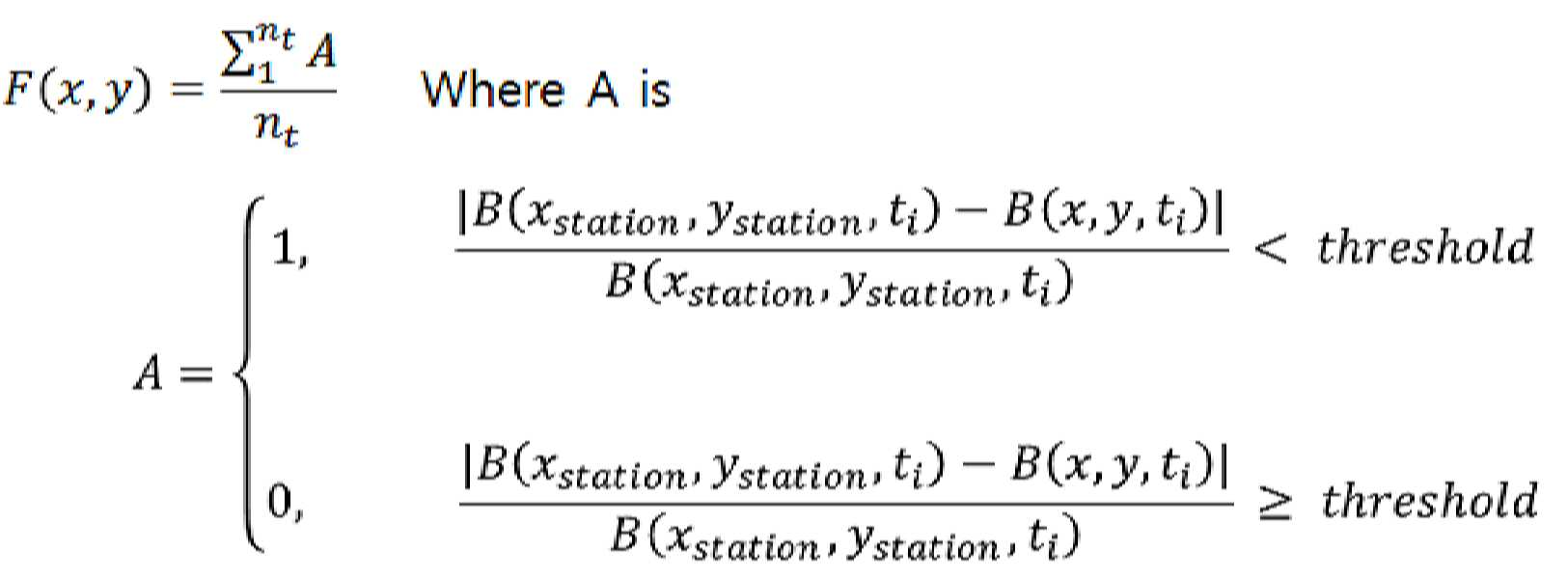
여기서, B(xstation, ystation, ti)는 환경 모니터링 대상 지역에 위치된 고정 관측소에서 장기에 걸쳐 ti 시간 간격별로 측정한 미세먼지, 기온, 습도, 강우, 풍향 등의 각각의 환경 정보 평균 값이고, B(x,y,ti)는 x, y 좌표를 가지는 단위 모니터링 지역에서 각 일 동안 ti 시간 간격 별로 예측된 기온, 습도, 강우 또는 풍향 중 하나 이상을 포함하는 각각의 기후 예측 정보들이다. 상기 nt는 상기 장기 장기 환경 정보 측정 기간에 포함되는 일 수 이다.Here, B (x station, y station, t i) each of the environmental information measured by t i time intervals over a long period in a fixed location in the environment the monitored area station fine dust, temperature, humidity, precipitation, wind direction, etc. An average value, B (x, y, t i ) is a forecast for each climate, including one or more of the predicted temperature, humidity, rainfall, or wind direction for each ti time interval for each day in a unit monitoring area with x and y coordinates. It is information. The nt is the number of days included in the long-term long-term environmental information measurement period.
여기서, F(x, y)는 환경 모니터링 대상 지역의 관측된 환경 정보 평균 값과 상기 환경 모니터링 대상 지역 내에 포함되는 단위 모니터링 지역의 기후 예측 값의 평균 값과의 유사도를 나타내는 함수이다. 즉, 고정 관측소에서 측정된 환경 정보 B(xstation, ystation, ti)와 각 단위 모니터링 지역에서 예측된 환경 정보 B(x, y,ti)의 차를 고정 관측소에서 측정된 환경 정보 B(xstation, ystation, ti)로 나눈 경우 기 설정된 값(threshold)보다 작은 경우, 관측된 환경 정보와 예측된 환경 정보의 차이가 크지 않으므로 환경 정보의 관측 값이 해당 단위 모니터링 지역에서 유효한 환경 정보로되고 이에 의해 A가 1의 값을 가진다. 이와 달리, 고정 관측소에서 측정된 환경 정보 B(xstation, ystation, ti)와 각 단위 모니터링 지역에서 예측된 환경 정보 B(x, y,ti)의 차를 고정 관측소에서 측정된 환경 정보 B(xstation, ystation, ti)로 나눈 경우 기 설정된 값(threshold)보다 큰 경우에는, 관측된 환경 정보와 예측된 환경 정보의 차이가 크므로 환경 정보의 관측 값이 해당 단위 모니터링 지역에서 유효하지 않은 환경 정보로 되고 이에 의해 A가 0의 값을 가진다. Here, F (x, y) is a function representing the similarity between the average value of the observed environmental information in the environment monitoring target area and the average value of the climate prediction value of the unit monitoring area included in the environment monitoring target area. That is, the difference between the environmental information B (x station , y station , t i ) measured at the station and the predicted environmental information B (x, y, t i ) at each unit monitoring area is the environmental information B measured at the station. When divided by (x station , y station , t i ), if the value is less than a preset value, the difference between the observed environment information and the predicted environment information is not large, so the observed value of the environment information is a valid environment in the unit monitoring area. It becomes information and thereby A has a value of 1. On the other hand, the difference between the environmental information B (x station , y station , t i ) measured at the station and the predicted environmental information B (x, y, t i ) at each unit monitoring area is the environmental information measured at the station. When divided by B (x station , y station , t i ), if it is larger than the preset value (threshold), the difference between the observed environmental information and the predicted environmental information is large, so the observed value of the environmental information is It becomes invalid environment information, and thus A has a value of 0.
이를 데이터베이스부(10)에 저장된 환경 정보 전체 기간 동안 평균한 값이 x,y 위치에서 유사도 F(x, y)의 값이 된다. The value averaged over the entire period of environment information stored in the
도 7은 우선 모니터링 지역 선정을 위한 관측소에서 측정된 환경 정보로서의 기온과 단위 모니터링 지역들의 예측된 환경 정보로서의 기온의 유사도를 나타내는 그래프이다. 7 is a graph showing the similarity between air temperature as environmental information measured at an observatory for selecting a monitoring area and air temperature as predicted environmental information of unit monitoring areas.
도 7에서, 전체 사각형은 환경 통합 모니터링 지역을 나타내며, 내부의 격자형으로 분할된 영역들이 상기 환경 통합 모니터링 지역에 포함되는 단위 모니터링 지역들을 나타낸다. 그리고 지상관측소 위치(S)에서의 값은 1로 설정하고, 각각의 단위 모니터링 지역들의 유사도 값을 기입한다. 이 후, 유사도가 기 설정된 값의 이하가 되는 지역들을 추출하고, 유사도가 낮은 순으로 우선순위를 부여하여 우선 모니터링 지역들을 설정한다.In FIG. 7, the entire square represents an environment integrated monitoring area, and the area divided into an internal grid shape represents unit monitoring areas included in the environment integrated monitoring area. Then, the value at the ground station location (S) is set to 1, and the similarity value of each unit monitoring area is entered. Thereafter, areas where the similarity is less than or equal to a predetermined value are extracted, and priority monitoring areas are set by giving priority in order of low similarity.
도 7의 경우에는 환경 정보 중 기온에 대한 유사도를 이용하여 우선 모니터링 지역들을 설정하였으나, 환경 정보들의 상관성을 고려하여, 강우에 대한 유사도 그래프를 추가로 작성한 후, 기온과 강우에 대한 유사도를 합한 유사도 그래프를 이용하여 우선 모니터링 지역들을 설정할 수도 있다.In the case of FIG. 7, the monitoring areas were first set by using the similarity to the temperature among the environmental information, but after considering the correlation of the environmental information, the similarity graph for the rainfall is additionally created, and then the similarity of the temperature and the rainfall is combined. You can also set the monitoring areas first using the graph.
우선 모니터링 지역들은 고정 관측소의 관측 값이 적용될 수 없는 지역들로 해당 지역에 대한 직접적인 환경 정보 관측을 필요로 하는 지역, 즉 환경 정보 모니터링 부재 지역이 된다.First of all, monitoring areas are areas where observations from fixed stations cannot be applied, and are areas that need direct environmental information observation for the area, that is, areas without environmental information monitoring.
상술한 바와 같이 우선 모니터링 지역이 설정된 후에는 환경 통합 모니터링 지역의 지도 상에 해당 영역을 표시하는 것에 의해 지도 상에서 환경 정보 모니터링 부재 지역을 파악할 수 있도록 할 수 있다.As described above, after the first monitoring area is set, it is possible to identify the area where environmental information monitoring is absent on the map by displaying the corresponding area on the map of the environment integrated monitoring area.
이러한 예로서, 도 8은 기온 모니터링 부재 지역을 나타내는 도면이고, 도 9는 강수량 모니터링 부재 지역을 나타내는 도면이다. 도 8 및 도 9에서 r은 우선 모니터링 지역을, S1은 환경 통합 모니터링 모듈을 이용한 환경 정보 측정 위치를 나타낸다.As an example of this, FIG. 8 is a view showing an area without temperature monitoring, and FIG. 9 is a view showing an area without precipitation monitoring. 8 and 9, r denotes a monitoring area first, and S1 denotes a location for measuring environmental information using an integrated environmental monitoring module.
또한, 상기 유사도 판단 그래프를 통해, 환경 통합 모니터링 대상 지역 내에서 유사도가 일정 비율 이하인 영역이 몇 %를 차지하는지도 지도 상에 표시할 수 있다.In addition, through the similarity determination graph, it is possible to display on the map a map in which a region in which the similarity is less than a certain percentage occupies a certain percentage in the area to be integrated environmental monitoring.
도 10은 단위 모니터링 지역들에 대한 기후예측부(20)에 의해 예측된 기온 값에 대한 고정 관측소에서 측정된 기온 값의 유사도가 60% 이하인 지역들이 97% 포함된 경우를 나타내는 유사도 판단도면이고, 도 11은 단위 모니터링 지역들에 대한 기후예측부(20)에 의해 예측된 강수량에 대한 고정 관측소에서 측정된 강수량 값의 유사도 2% 이하 지역이 99% 포함된 경우를 나타내는 유사도 판단도면을 나타낸다.FIG. 10 is a similarity judgment drawing showing a case where 97% of regions having a similarity of the temperature value measured at a fixed station with respect to the temperature value predicted by the
또한, 상기 우선 모니터링 지역의 선정은 토지피복도를 함께 적용하여 수행될 수도 있다. 도 12는 토지피복도를 나타내는 도면이고, 도 13은 토지피복도 범례의 표를 나타내는 도면이다.In addition, the selection of the priority monitoring area may be performed by applying the land covering degree together. 12 is a view showing the land cover diagram, and FIG. 13 is a view showing a table of the land cover diagram legend.
즉, 도 12 및 도 13을 참조하여 도로망 또는 산업 지역을 포함하는 지역들에서 많은 미세먼지가 발생되므로 해당 지역들의 단위 모니터링 지역에 가중치를 부여하는 등의 방식으로 우선 모니터링 지역 설정에 토지피복도를 반영할 수 있다.That is, referring to FIGS. 12 and 13, since a lot of fine dust is generated in areas including a road network or an industrial area, the land covering degree is first reflected in the setting of the monitoring area in a manner such as weighting the unit monitoring area of the areas. can do.
다시 도 6을 참조하여 설명하면, 도 7 내지 도 13의 설명에서와 같이 상기 우선 모니터링 지역 설정 단계(S20)가 수행된 후에는, 상기 모니터링 주기 결정부가 측정 대상 환경 정보와 측정을 위한 이동 속도를 기준으로 모니터링 주기를 결정하는 모니터링 주기 결정 단계(S30)를 수행한다. 이때, 모니터링 주기는 모니터링 대상 항목에 따라 상이하게 요구되는 데이터 수집 빈도를 최소화하도록 설정됨은 상술한 바와 같다.Referring again to FIG. 6, after the priority monitoring area setting step (S20) is performed as described in FIGS. 7 to 13, the monitoring cycle determining unit determines the measurement target environment information and the moving speed for measurement. A monitoring cycle determination step (S30) for determining a monitoring cycle as a reference is performed. At this time, it is as described above that the monitoring cycle is set to minimize the frequency of data collection required differently according to the monitoring target item.
다음으로, 모니터링 주기가 결정된 후에는, 상기 환경 정보 측정부가 상기 결정된 모니터링 주기 및 상기 우선 모니터링 지역의 우선순위별로 선택적인 환경 통합 모니터링을 수행하는 선택적 환경 정보 측정 단계(S40)을 수행한다.Next, after the monitoring period is determined, the environmental information measurement unit performs an optional environmental information measurement step (S40) for performing selective environmental integrated monitoring by the determined monitoring period and priority of the priority monitoring area.
상기 선택적 환경 정보 측정 단계(S40)에서는 미세먼지 측정 여부를 선택하는 것으로서, 도 14는 본 발명의 실시예의 선택적 환경 데이터 취득 단계(S40)의 상세 처리과정을 나타내는 환경 통합 모니터링 방법의 처리과정을 나타내는 순서도이다.In the optional environmental information measurement step (S40), whether to measure fine dust is selected, and FIG. 14 shows the processing process of the environmental integrated monitoring method showing the detailed processing of the optional environmental data acquisition step (S40) of the embodiment of the present invention. It is a flowchart.
도 14와 같이, 환경 정보 중 미세먼지의 측정을 수행하고자 하는 경우, 상기 환경 정보 측정부(40)는 환경모니터링부(200)를 이용하여 현재 위치의 GPS 정보, 온도 및 습도를 측정하는 GPS 위치 정보 수집 및 온도/습도 측정 단계(S41)를 수행한다.As shown in FIG. 14, when it is desired to measure fine dust among environmental information, the environmental information measuring unit 40 uses the
다음으로, 측정된 습도가 강우 습도 값 이상인지를 판단하는 습도판단단계(S42)를 수행한다.Next, a humidity determination step (S42) is performed to determine whether the measured humidity is higher than a rainfall humidity value.
상기 습도판단단계(S42)의 판단 결과, 습도가 강우 습도 값 이하인 경우에는 미세먼지를 측정하는 미세먼지 측정단계(S45)를 수행하고, 측정된 기온, 습도, 강우, 풍향 및 미세먼지 정보, 측정 위치, 날짜 및 시간 정보를 포함하는 환경 정보를 원격지로 전송하는 환경정보 전송단계(S46)를 수행한다.As a result of the determination of the humidity determination step (S42), if the humidity is below the rainfall humidity value, a fine dust measurement step (S45) for measuring fine dust is performed, and the measured temperature, humidity, rainfall, wind direction and fine dust information, measurement The environmental information transmission step (S46) of transmitting environmental information including location, date, and time information to a remote location is performed.
이와 달리, 상기 습도판단단계(S42)의 판단 결과, 습도가 강우 습도 이상인 경우에는 강우량을 측정하는 강우량측정단계(S43)를 수행한 후, 측정된 강우량이 미세먼지를 없앨 수 있는 정도의 유효 강우량인지를 판단하는 유효강우판단단계(S44)를 수행한다.On the other hand, as a result of the determination of the humidity determination step (S42), if the humidity is higher than the rainfall humidity, after performing the rainfall measurement step (S43) for measuring rainfall, the measured rainfall is effective rainfall to remove fine dust. An effective rainfall determination step (S44) for determining cognition is performed.
유효강우판단단계(S44)의 판단 결과 측정된 강우량이 유효강우량 미만인 경우에는 미세먼지 측정 단계(S45)를 수행하여 미세먼지를 측정한 후, 측정된 기온, 습도, 강우, 풍향 및 미세먼지 정보, 측정 위치, 날짜 및 시간 정보를 포함하는 환경 정보를 원격지로 전송하는 환경정보 전송단계(S46)를 수행한다.If the measured rainfall is less than the effective rainfall amount as a result of the determination of the effective rainfall determination step (S44), after measuring the fine dust by performing the fine dust measurement step (S45), the measured temperature, humidity, rainfall, wind direction and fine dust information, The environmental information transmission step (S46) of transmitting environmental information including measurement location, date and time information to a remote location is performed.
이와 달리, 유효강우판단단계(S44)의 판단 결과 측정된 강우량이 유효강우량 이상인 미세먼지 측정 단계(S45)를 수행함이 없이, 측정된 기온, 습도, 강우 및 풍향 정보, 측정 위치, 날짜 및 시간 정보를 포함하는 환경 정보를 원격지로 전송하는 환경정보 전송단계(S46)를 수행한다.Alternatively, the measured temperature, humidity, rainfall and wind direction information, measurement location, date and time information, without performing a fine dust measurement step (S45) in which the measured rainfall is equal to or greater than the effective rainfall amount as a result of the determination of the effective rainfall determination step (S44) The environmental information transmission step (S46) of transmitting environmental information including a remote location is performed.
전술한 본 발명의 설명은 예시를 위한 것이며, 본 발명이 속하는 기술분야의 통상의 지식을 가진 자는 본 발명의 기술적 사상이나 필수적인 특징을 변경하지 않고서 다른 구체적인 형태로 쉽게 변형이 가능하다는 것을 이해할 수 있을 것이다. 그러므로 이상에서 기술한 실시예들은 모든 면에서 예시적인 것이며 한정적이 아닌 것으로 이해해야만 한다. 예를 들어, 단일형으로 설명되어 있는 각 구성 요소는 분산되어 실시될 수도 있으며, 마찬가지로 분산된 것으로 설명되어 있는 구성 요소들도 결합된 형태로 실시될 수 있다.The above description of the present invention is for illustration only, and a person having ordinary knowledge in the technical field to which the present invention pertains can understand that it can be easily modified into other specific forms without changing the technical spirit or essential features of the present invention. will be. Therefore, it should be understood that the embodiments described above are illustrative in all respects and not restrictive. For example, each component described as a single type may be implemented in a distributed manner, and similarly, components described as distributed may be implemented in a combined form.
본 발명의 범위는 후술하는 청구범위에 의하여 나타내어지며, 청구범위의 의미 및 범위 그리고 그 균등 개념으로부터 도출되는 모든 변경 또는 변형된 형태가 본 발명의 범위에 포함되는 것으로 해석되어야 한다.The scope of the present invention is indicated by the following claims, and all changes or modifications derived from the meaning and scope of the claims and equivalent concepts should be interpreted to be included in the scope of the present invention.
상기 유속감지부로부터 입력되는 측정 대상 공기의 유속에 상기 펌프부의 공기 흡입부의 단면적을 곱하여 유량으로 환산하여 전체 흡입 유량을 검출한 후, 정지 상태에서의 흡입 유량(Q0)이 되도록 흡입출력을 제어하는 것에 의해 이동체의 이동에 의해 추가된 유량(Qa)을 제거하는 흡입유량 보정을 수행하도록 구성되는 것을 특징으로 하는 환경 통합 모니터링 모듈.After multiplying the cross-sectional area of the air suction part of the pump part by the flow rate of the air to be measured input from the flow rate detecting part, converting it into a flow rate to detect the total suction flow rate, and controlling the suction power to be the suction flow rate (Q 0 ) in a stopped state. It characterized in that it is configured to perform a suction flow correction to remove the flow rate (Q a ) added by the movement of the moving object.
Claims (15)
상기 데이터베이스부로부터 환경 통합 모니터링 대상 지역의 지도정보와 고정 관측소 측정 환경 정보를 기후예측모델에 적용하여 상기 환경 통합 모니터링 대상 지역 내의 분할한 단위 모니터링 지역들 각각에 대한 기후 예측 정보를 출력하는 기후예측부;
상기 기후 예측 정보와 상기 환경 통합 모니터링 대상 지역의 관측된 장기 환경 정보를 비교하여 기 설정된 비율 이상의 차이를 보이는 단위 모니터링 지역들을 우선 모니터링 지역으로 선정하는 우선 모니터링 지역 선정부; 및
환경 통합 모니터링 모듈을 구비하여 상기 우선 모니터링 지역의 우선순위별로 환경 통합 모니터링을 수행하는 환경 정보 측정부;를 포함하여 구성되는 것을 특징으로 하는 환경 통합 모니터링 장치.A database unit that stores map information of the areas subject to integrated environmental monitoring and long-term environmental information of the area;
The climate prediction unit outputs climate prediction information for each of the divided unit monitoring areas in the environment integrated monitoring target area by applying map information of the environment-integrated monitoring target area and fixed station measurement environment information to the climate prediction model from the database unit. ;
A priority monitoring area selection unit that compares the climate prediction information with the observed long-term environmental information of the environment-integrated monitoring target area and selects unit monitoring areas having a difference of a predetermined ratio or more as a priority monitoring area; And
Environmental integrated monitoring device comprising a; environmental information monitoring unit having an integrated environmental monitoring module for performing environmental integrated monitoring by priority of the priority monitoring area.
도로망 정보, 주거, 산업 또는 농업 지역 정보 중 하나 이상을 포함하는 토지피복도 정보 중 하나 이상을 포함하는 것을 특징으로 하는 환경 통합 모니터링 장치.The method of claim 1, wherein the map information,
Integrated environmental monitoring device, characterized in that it comprises at least one of the land cover information, including one or more of the road network information, residential, industrial or agricultural information.
미세먼지, 기온, 습도, 강우 또는 풍향 정보 중 하나 이상을 포함하는 것을 특징으로 하는 환경 통합 모니터링 장치.The method of claim 1, wherein the environmental information subject to environmental monitoring is:
An integrated environmental monitoring device comprising one or more of fine dust, temperature, humidity, rainfall or wind direction information.
상기 기후 예측 정보는 상기 장기 환경 정보 저장 기간 동안 예측된 기온, 습도, 풍향 또는 강우 중 하나 이상의 평균 값이고,
상기 장기 환경 정보는 상기 환경 통합 모니터링 대상 지역 전체의 장기 저장된 기온, 습도, 풍향 또는 강우 중 하나 이상의 평균 값인 특징으로 하는 환경 통합 모니터링 장치.According to claim 1, Among the information compared by the priority monitoring area selection unit,
The climate prediction information is an average value of one or more of temperature, humidity, wind direction or rainfall predicted during the long-term environmental information storage period,
The long-term environmental information is an integrated environmental monitoring device characterized in that the average value of one or more of the long-term stored temperature, humidity, wind direction or rainfall in the entire area of the environment integrated monitoring target.
미세먼지의 측정 시,
측정된 습도가 강우 습도 이하인 경우와, 측정된 강우가 미세먼지 유무에 영향을 주는 유효 강우 이하인 경우 미세먼지를 선택적으로 측정하도록 구성되는 것을 특징으로 하는 환경 통합 모니터링 장치.According to claim 1, The environmental information measuring unit,
When measuring fine dust,
Environment-integrated monitoring device, characterized in that configured to selectively measure fine dust when the measured humidity is below the rainfall humidity and when the measured rainfall is less than the effective rainfall affecting the presence or absence of fine dust.
모니터링 대상 환경 정보 또는 측정 중 이동 속도에 따라 모니터링 주기를 설정하는 모니터링 주기 결정부;를 더 포함하여 구성되는 것을 특징으로 하는 환경 통합 모니터링 장치.According to claim 1,
An environment-integrated monitoring device comprising a monitoring cycle determining unit for setting a monitoring cycle according to the monitoring target environment information or a moving speed during measurement.
상기 이동체의 이동 방향측의 전면에 형성되는 관형의 유입관과, 상기 유입관의 하류측 단면으로부터 확장되며 외주면에 배치되는 하나 이상의 보조유입구멍이 형성되는 확장관 및 상기 확장관의 단부의 직경을 가지고 연장 형성되어 내부에 측정 대상 공기의 흐름을 형성하고, 상기 환경 통합 모니터링부가 설치되는 측정관을 포함하여, 외부의 공기를 유입 받은 후 통합 환경 모니터링을 위한 유속으로 변환하여 배출하는 것에 의해 내부에 측정 대상 공기의 흐름을 형성하는 관측관; 및
상기 관측관의 내부에 설치되어 상기 측정 대상공기의 상태를 검출하여 통합 환경 모니터링 정보를 생성한 후 원격지로 전송하는 환경 통합 모니터링부;를 포함하여 구성되는 것을 특징으로 하는 환경 통합 모니터링 장치.According to claim 1, The integrated environmental monitoring module,
The diameter of the end portion of the expansion pipe and the expansion pipe which is formed on the front circumferential side of the moving direction of the moving body and at least one auxiliary inflow hole extending from the downstream end face of the inflow pipe and disposed on the outer circumferential surface is formed. It is formed to be extended and forms a flow of air to be measured inside, including a measuring tube in which the environment integrated monitoring unit is installed, and receives the outside air, converts it into a flow rate for integrated environment monitoring, and discharges the inside. An observation tube forming a flow of air to be measured; And
Environment-integrated monitoring device, characterized in that comprises a; installed inside the observation tube to detect the state of the measurement target air, and generates integrated environmental monitoring information and transmits it to a remote environment.
상기 측정관 내부의 상기 측정 대상 공기의 유속을 검출하는 유속감지부;
상기 측정 대상 공기에 포함되는 미세먼지를 검출하는 미세먼지센서부;
상기 측정 대상 공기의 습도, 온도, 강우 또는 풍향 중 하나 이상을 검출하여 기상정보를 생성하는 기상측정센서부;
환경 통합 모니터링 되는 위치 정보를 생성하는 GPS모듈;
상기 미세먼지센서부와 상기 기상측정센서부에서 측정된 미세먼지검출 신호와 기상측정신호를 입력받은 후 연산처리를 수행하여 측정 지역의 미세먼지정보와 기상정보를 생성하여 출력하는 제어부; 및
상기 제어부에서 출력된 미세먼지정보와 기상정보를 외부로 전송하는 데이터 전송부;를 포함하여 구성되는 것을 특징으로 하는 환경 통합 모니터링 장치.According to claim 8, The integrated environmental monitoring unit,
A flow rate detection unit detecting a flow rate of the measurement target air inside the measurement tube;
A fine dust sensor unit for detecting fine dust contained in the measurement target air;
A weather measurement sensor unit for generating weather information by detecting one or more of humidity, temperature, rainfall or wind direction of the measurement target air;
GPS module for generating location information to be monitored in an integrated environment;
A control unit for generating and outputting fine dust information and weather information of a measurement area by performing a calculation process after receiving the fine dust detection signal and the weather measurement signal measured by the fine dust sensor unit and the weather measurement sensor unit; And
Environment-integrated monitoring device comprising a; data transmission unit for transmitting the fine dust information and weather information output from the control unit to the outside.
상기 유속감지부로부터 입력되는 측정 대상 공기의 유속에 상기 펌프부의 공기 흡입부의 단면적을 곱하여 유량으로 환산하여 전체 흡입 유량을 검출한 후, 정지 상태에서의 흡입 유량(Q0)이 되도록 흡입출력을 제어하는 것에 의해 이동체의 이동에 의해 추가된 유량(Qa)을 제거하는 흡입유량 보정을 수행하여 기 설정된 흡입 유량을 가지도록 상기 측정 대상공기를 흡입하는 펌프부;
상기 펌프부를 통해 유입된 측정 대상 공기에 빛을 조사한 후 산란되는 빛의세기를 검출하는 산란감지부; 및
상기 산란감지부에서 검출된 산란되는 빛의 세기 신호에 대한 연산을 수행하여 상기 측정 대상 공기에 포함되는 미세먼지의 크기 또는 농도 값을 산출하여 상기 제어부로 출력하는 계산처리부;를 포함하여 구성되는 것을 특징으로 하는 환경 통합 모니터링 장치.The method of claim 9, The fine dust sensor unit,
After multiplying the cross-sectional area of the air suction part of the pump part by the flow rate of the air to be measured input from the flow rate detecting part, converting it into a flow rate to detect the total suction flow rate, and controlling the suction power to be the suction flow rate (Q 0 ) in a stopped state. A pump unit that sucks the air to be measured to have a preset suction flow rate by performing a suction flow rate correction that removes the added flow rate Q a by the movement of the moving object;
A scattering detection unit that detects the intensity of light scattered by irradiating light to the measurement target air introduced through the pump unit; And
The calculation processing unit calculates the size or concentration value of the fine dust contained in the measurement target air by performing an operation on the scattered light intensity signal detected by the scattering detection unit and outputs it to the control unit. Environmental integrated monitoring device characterized by.
상기 기후예측부가 환경 통합 모니터링 대상 지역을 일정 영역으로 분할한 단위 모니터링 지역들 각각에 대한 기후 예측 정보를 생성하는 단위 모니터링 지역별 기후 예측 단계;
상기 우선 모니터링 지역 선정부가 상기 단위 모니터링 지역별 기후 예측 정보와 상기 데이터베이스부에 저장된 상기 환경 통합 모니터링 대상 지역 전체의 환경 정보를 비교하여, 차이의 비율이 일정 값 이상인 단위 모니터링 지역들을 우선 모니터링 지역들로 선정하는 우선 모니터링 지역 선정 단계;
상기 모니터링 주기 결정부가 측정 대상 환경 정보와 측정을 위한 이동 속도를 기준으로 모니터링 주기를 결정하는 모니터링 주기 결정 단계; 및
상기 환경 정보 측정부가 상기 결정된 모니터링 주기 및 상기 우선 모니터링 지역의 우선순위별로 선택적인 환경 통합 모니터링을 수행하는 선택적 환경 정보 측정 단계;를 포함하는 것을 특징으로 하는 환경 통합 모니터링 방법.In the environmental integrated monitoring method by the environmentally integrated motoring device having a database unit for storing long-term environmental information and map information, climate forecasting unit, priority monitoring area selection unit, monitoring cycle determination unit and environmental information measurement unit,
A climate prediction step for each unit monitoring area, in which the climate prediction unit generates climate prediction information for each of the unit monitoring areas where the environment-integrated monitoring target area is divided into a predetermined area;
The priority monitoring area selection unit compares climate prediction information for each unit monitoring area with environmental information for the entire environment-monitored area stored in the database unit, and selects unit monitoring areas having a difference ratio equal to or greater than a predetermined value as priority monitoring areas Priority monitoring area selection step;
A monitoring period determination step in which the monitoring period determination unit determines a monitoring period based on the measurement target environment information and a moving speed for measurement; And
And an optional environmental information measurement step in which the environmental information measurement unit performs selective environmental integrated monitoring according to the determined monitoring cycle and priority of the priority monitoring area.
위도와 경도 정보, 도로망 정보, 주거, 산업 또는 농업 지역 정보 중 하나 이상을 포함하는 토지피복도 정보 중 하나 이상을 포함하는 것을 특징으로 하는 환경 통합 모니터링 방법.The method of claim 11, wherein the map information,
A method for integrated environmental monitoring, comprising one or more of land cover information including one or more of latitude and longitude information, road network information, residential, industrial or agricultural area information.
미세먼지, 기온, 습도, 강우 또는 풍향 정보 중 하나 이상을 포함하는 것을 특징으로 하는 환경 통합 모니터링 방법.12. The method of claim 11, The environment integrated monitoring target environmental information,
A method for integrated environmental monitoring, comprising one or more of fine dust, temperature, humidity, rainfall, or wind direction information.
상기 기후 예측 정보는 상기 장기 환경 정보 저장 기간 동안 예측된 기온, 습도, 풍향 또는 강우 중 하나 이상의 평균 값이고,
상기 장기 환경 정보는 상기 환경 통합 모니터링 대상 지역 전체의 장기 저장된 기온, 습도, 풍향 또는 강우 중 하나 이상의 평균 값인 것을 특징으로 하는 환경 통합 모니터링 방법.12. The method of claim 11, wherein among the information compared in the priority monitoring area setting step
The climate prediction information is an average value of one or more of temperature, humidity, wind direction or rainfall predicted during the long-term environmental information storage period,
The long-term environmental information is an integrated environmental monitoring method, characterized in that the average value of at least one of the long-term stored temperature, humidity, wind direction or rainfall in the entire area to be integrated environmental monitoring.
미세먼지 측정 시,
측정된 습도가 강우 습도 이하인 경우와, 측정된 강우가 미세먼지 유무에 영향을 주는 유효 강우 이하인 경우 미세먼지를 선택적으로 측정하는 것을 특징으로 하는 환경 통합 모니터링 방법.According to claim 11, The optional environmental measurement information measurement step,
When measuring fine dust,
A method for integrated environmental monitoring, characterized in that selectively measures fine dust when the measured humidity is below the rainfall humidity and when the measured rainfall is below the effective rainfall that affects the presence or absence of fine dust.
Priority Applications (1)
| Application Number | Priority Date | Filing Date | Title |
|---|---|---|---|
| KR1020180129143A KR102250795B1 (en) | 2018-10-26 | 2018-10-26 | Integrated Environment Monitoring Apparatus And the method thereof using Integrated Environment Monitoring Module |
Applications Claiming Priority (1)
| Application Number | Priority Date | Filing Date | Title |
|---|---|---|---|
| KR1020180129143A KR102250795B1 (en) | 2018-10-26 | 2018-10-26 | Integrated Environment Monitoring Apparatus And the method thereof using Integrated Environment Monitoring Module |
Publications (2)
| Publication Number | Publication Date |
|---|---|
| KR20200047103A true KR20200047103A (en) | 2020-05-07 |
| KR102250795B1 KR102250795B1 (en) | 2021-05-11 |
Family
ID=70734099
Family Applications (1)
| Application Number | Title | Priority Date | Filing Date |
|---|---|---|---|
| KR1020180129143A Active KR102250795B1 (en) | 2018-10-26 | 2018-10-26 | Integrated Environment Monitoring Apparatus And the method thereof using Integrated Environment Monitoring Module |
Country Status (1)
| Country | Link |
|---|---|
| KR (1) | KR102250795B1 (en) |
Cited By (11)
| Publication number | Priority date | Publication date | Assignee | Title |
|---|---|---|---|---|
| KR20220022169A (en) * | 2020-08-18 | 2022-02-25 | 주식회사 세스코 | Environmental managing system and method based on geofence |
| KR20220022168A (en) * | 2020-08-18 | 2022-02-25 | 주식회사 세스코 | Environmental managing system and method based on geofence |
| KR102374002B1 (en) * | 2021-10-08 | 2022-03-15 | 주식회사 에어핏 | Device, method and program for measuring fine dust concentration through satellite imagery |
| CN114858205A (en) * | 2021-02-03 | 2022-08-05 | 盟立自动化股份有限公司 | Warehousing equipment and monitoring method of warehousing equipment |
| CN115876964A (en) * | 2023-01-31 | 2023-03-31 | 北方工业大学 | Mobile monitoring and early warning method and system for city block climate environment and carbon emission |
| CN116027461A (en) * | 2022-12-23 | 2023-04-28 | 上海航天控制技术研究所 | Center control method and system for full-automatic space target photoelectric observation station |
| CN116577252A (en) * | 2023-04-23 | 2023-08-11 | 中国科学院空天信息创新研究院 | Atmospheric fine particle concentration measurement method, device, equipment and medium |
| CN116880461A (en) * | 2023-08-24 | 2023-10-13 | 重庆长安汽车股份有限公司 | Detection method and device of domain controller, computer equipment and storage medium |
| CN117198019A (en) * | 2023-11-07 | 2023-12-08 | 山东怡鲁科技有限公司 | An intelligent early warning system for smart archives warehouses based on multi-sensors |
| KR20240033466A (en) * | 2022-09-05 | 2024-03-12 | 국립부경대학교 산학협력단 | System and method for analyzing atmospheric environments of urban area |
| CN119720771A (en) * | 2024-12-09 | 2025-03-28 | 台州通禾流体控制股份有限公司 | A humidity sensor monitoring method and system for moisture-proof performance evaluation |
Families Citing this family (1)
| Publication number | Priority date | Publication date | Assignee | Title |
|---|---|---|---|---|
| KR102691255B1 (en) * | 2021-12-16 | 2024-08-05 | 재단법인 차세대융합기술연구원 | Smart city management system for city-wide industrial cluster and managing method thereof |
Citations (5)
| Publication number | Priority date | Publication date | Assignee | Title |
|---|---|---|---|---|
| JP2006338577A (en) * | 2005-06-06 | 2006-12-14 | Chugoku Electric Power Co Inc:The | Environmental data providing system |
| JP2008170249A (en) * | 2007-01-11 | 2008-07-24 | Earth Watch Corp | Environmental measuring system |
| KR101456524B1 (en) | 2013-07-29 | 2014-11-03 | (주)헤르메시스 | Rainfall information system and rainfall information server using data from rain sensor of vehicle, rainfall meter and radar rainfall, with big data process |
| KR20170060487A (en) * | 2015-11-24 | 2017-06-01 | 한국외국어대학교 연구산학협력단 | Urban area climate analysing system and method |
| KR101900777B1 (en) * | 2017-12-27 | 2018-09-20 | 한국과학기술정보연구원 | Server for city enviromental analysis, and control method thereof |
-
2018
- 2018-10-26 KR KR1020180129143A patent/KR102250795B1/en active Active
Patent Citations (5)
| Publication number | Priority date | Publication date | Assignee | Title |
|---|---|---|---|---|
| JP2006338577A (en) * | 2005-06-06 | 2006-12-14 | Chugoku Electric Power Co Inc:The | Environmental data providing system |
| JP2008170249A (en) * | 2007-01-11 | 2008-07-24 | Earth Watch Corp | Environmental measuring system |
| KR101456524B1 (en) | 2013-07-29 | 2014-11-03 | (주)헤르메시스 | Rainfall information system and rainfall information server using data from rain sensor of vehicle, rainfall meter and radar rainfall, with big data process |
| KR20170060487A (en) * | 2015-11-24 | 2017-06-01 | 한국외국어대학교 연구산학협력단 | Urban area climate analysing system and method |
| KR101900777B1 (en) * | 2017-12-27 | 2018-09-20 | 한국과학기술정보연구원 | Server for city enviromental analysis, and control method thereof |
Cited By (15)
| Publication number | Priority date | Publication date | Assignee | Title |
|---|---|---|---|---|
| KR20220022168A (en) * | 2020-08-18 | 2022-02-25 | 주식회사 세스코 | Environmental managing system and method based on geofence |
| KR20220022169A (en) * | 2020-08-18 | 2022-02-25 | 주식회사 세스코 | Environmental managing system and method based on geofence |
| CN114858205B (en) * | 2021-02-03 | 2024-03-01 | 盟立自动化股份有限公司 | Storage equipment and monitoring method thereof |
| CN114858205A (en) * | 2021-02-03 | 2022-08-05 | 盟立自动化股份有限公司 | Warehousing equipment and monitoring method of warehousing equipment |
| KR102374002B1 (en) * | 2021-10-08 | 2022-03-15 | 주식회사 에어핏 | Device, method and program for measuring fine dust concentration through satellite imagery |
| KR102425572B1 (en) * | 2021-10-08 | 2022-07-29 | 주식회사 에어핏 | Fine dust concentration measurement method, device and program using concentration measurement model and concentration estimation model reflecting regional and seasonal characteristics |
| KR20240033466A (en) * | 2022-09-05 | 2024-03-12 | 국립부경대학교 산학협력단 | System and method for analyzing atmospheric environments of urban area |
| CN116027461A (en) * | 2022-12-23 | 2023-04-28 | 上海航天控制技术研究所 | Center control method and system for full-automatic space target photoelectric observation station |
| CN115876964B (en) * | 2023-01-31 | 2024-01-23 | 北方工业大学 | An urban neighborhood climate environment and carbon emission mobile monitoring and early warning method and system |
| CN115876964A (en) * | 2023-01-31 | 2023-03-31 | 北方工业大学 | Mobile monitoring and early warning method and system for city block climate environment and carbon emission |
| CN116577252A (en) * | 2023-04-23 | 2023-08-11 | 中国科学院空天信息创新研究院 | Atmospheric fine particle concentration measurement method, device, equipment and medium |
| CN116880461A (en) * | 2023-08-24 | 2023-10-13 | 重庆长安汽车股份有限公司 | Detection method and device of domain controller, computer equipment and storage medium |
| CN117198019A (en) * | 2023-11-07 | 2023-12-08 | 山东怡鲁科技有限公司 | An intelligent early warning system for smart archives warehouses based on multi-sensors |
| CN117198019B (en) * | 2023-11-07 | 2024-01-30 | 山东怡鲁科技有限公司 | An intelligent early warning system for smart archives warehouses based on multi-sensors |
| CN119720771A (en) * | 2024-12-09 | 2025-03-28 | 台州通禾流体控制股份有限公司 | A humidity sensor monitoring method and system for moisture-proof performance evaluation |
Also Published As
| Publication number | Publication date |
|---|---|
| KR102250795B1 (en) | 2021-05-11 |
Similar Documents
| Publication | Publication Date | Title |
|---|---|---|
| KR102250795B1 (en) | Integrated Environment Monitoring Apparatus And the method thereof using Integrated Environment Monitoring Module | |
| US12163939B2 (en) | Gas leak detection system | |
| EP2115479B1 (en) | Method and system for detecting and monitoring emissions | |
| EP3318871B1 (en) | Internet of vehicles-based air quality detecting system | |
| Berghmans et al. | Exposure assessment of a cyclist to PM10 and ultrafine particles | |
| US8949037B2 (en) | Method and system for detecting and monitoring emissions | |
| US11378563B2 (en) | Method for quantifying fugitive methane emissions rate using surface methane concentration | |
| Ganji et al. | Design, calibration, and testing of a mobile sensor system for air pollution and built environment data collection: The urban scanner platform | |
| EP3183722B1 (en) | Station for the integrated monitoring of environment and traffic | |
| Lee et al. | A mobile sensor network to map carbon dioxide emissions in urban environments | |
| KR102111121B1 (en) | Source tracking system using drones and real-time mobile measurement vehicles | |
| CN109765337A (en) | A kind of pollution source discrimination and its system | |
| Miskell et al. | Use of a handheld low-cost sensor to explore the effect of urban design features on local-scale spatial and temporal air quality variability | |
| CN207528268U (en) | A kind of atmospheric environment observation vehicle | |
| KR102129929B1 (en) | Source tracking method using drones and real-time mobile measurement vehicles | |
| KR102129931B1 (en) | Source Tracking Method Using Drones | |
| CN115796034B (en) | Road dust contribution assessment system and method based on machine learning and numerical models | |
| CN113655175A (en) | Gridding air monitoring method, system, computer equipment and storage medium | |
| KR102253762B1 (en) | Particulate matter monitoring system and capturing device of air using vehicle | |
| Isakov et al. | A method of assessing air toxics concentrations in urban areas using mobile platform measurements | |
| CN117934212A (en) | Construction process monitoring method based on IOT technology digital visualization platform | |
| TWM569844U (en) | System, application platform and sampling device for monitoring wide-area environment quality | |
| CN120181401B (en) | Landfill methane emission monitoring method and system for air-ground joint monitoring | |
| TWI619929B (en) | Air quality monitoring system and method thereof | |
| Lambey et al. | Measurement of PM10, PM2. 5, NO2, and SO2 Using Sensors |
Legal Events
| Date | Code | Title | Description |
|---|---|---|---|
| PA0109 | Patent application |
St.27 status event code: A-0-1-A10-A12-nap-PA0109 |
|
| PA0201 | Request for examination |
St.27 status event code: A-1-2-D10-D11-exm-PA0201 |
|
| D13-X000 | Search requested |
St.27 status event code: A-1-2-D10-D13-srh-X000 |
|
| D14-X000 | Search report completed |
St.27 status event code: A-1-2-D10-D14-srh-X000 |
|
| E902 | Notification of reason for refusal | ||
| PE0902 | Notice of grounds for rejection |
St.27 status event code: A-1-2-D10-D21-exm-PE0902 |
|
| PG1501 | Laying open of application |
St.27 status event code: A-1-1-Q10-Q12-nap-PG1501 |
|
| P11-X000 | Amendment of application requested |
St.27 status event code: A-2-2-P10-P11-nap-X000 |
|
| P13-X000 | Application amended |
St.27 status event code: A-2-2-P10-P13-nap-X000 |
|
| E90F | Notification of reason for final refusal | ||
| PE0902 | Notice of grounds for rejection |
St.27 status event code: A-1-2-D10-D21-exm-PE0902 |
|
| P11-X000 | Amendment of application requested |
St.27 status event code: A-2-2-P10-P11-nap-X000 |
|
| P13-X000 | Application amended |
St.27 status event code: A-2-2-P10-P13-nap-X000 |
|
| E701 | Decision to grant or registration of patent right | ||
| PE0701 | Decision of registration |
St.27 status event code: A-1-2-D10-D22-exm-PE0701 |
|
| GRNT | Written decision to grant | ||
| PR0701 | Registration of establishment |
St.27 status event code: A-2-4-F10-F11-exm-PR0701 |
|
| PR1002 | Payment of registration fee |
St.27 status event code: A-2-2-U10-U11-oth-PR1002 Fee payment year number: 1 |
|
| PG1601 | Publication of registration |
St.27 status event code: A-4-4-Q10-Q13-nap-PG1601 |
|
| PR1001 | Payment of annual fee |
St.27 status event code: A-4-4-U10-U11-oth-PR1001 Fee payment year number: 4 |
|
| R18-X000 | Changes to party contact information recorded |
St.27 status event code: A-5-5-R10-R18-oth-X000 |
|
| R18-X000 | Changes to party contact information recorded |
St.27 status event code: A-5-5-R10-R18-oth-X000 |
|
| PR1001 | Payment of annual fee |
St.27 status event code: A-4-4-U10-U11-oth-PR1001 Fee payment year number: 5 |
|
| P22-X000 | Classification modified |
St.27 status event code: A-4-4-P10-P22-nap-X000 |