KR20130068463A - System for providing history information using location based information service and the method - Google Patents
System for providing history information using location based information service and the method Download PDFInfo
- Publication number
- KR20130068463A KR20130068463A KR1020110135638A KR20110135638A KR20130068463A KR 20130068463 A KR20130068463 A KR 20130068463A KR 1020110135638 A KR1020110135638 A KR 1020110135638A KR 20110135638 A KR20110135638 A KR 20110135638A KR 20130068463 A KR20130068463 A KR 20130068463A
- Authority
- KR
- South Korea
- Prior art keywords
- user terminal
- information
- image
- management server
- specific target
- Prior art date
- Legal status (The legal status is an assumption and is not a legal conclusion. Google has not performed a legal analysis and makes no representation as to the accuracy of the status listed.)
- Abandoned
Links
Images


Classifications
-
- G—PHYSICS
- G06—COMPUTING OR CALCULATING; COUNTING
- G06Q—INFORMATION AND COMMUNICATION TECHNOLOGY [ICT] SPECIALLY ADAPTED FOR ADMINISTRATIVE, COMMERCIAL, FINANCIAL, MANAGERIAL OR SUPERVISORY PURPOSES; SYSTEMS OR METHODS SPECIALLY ADAPTED FOR ADMINISTRATIVE, COMMERCIAL, FINANCIAL, MANAGERIAL OR SUPERVISORY PURPOSES, NOT OTHERWISE PROVIDED FOR
- G06Q50/00—Information and communication technology [ICT] specially adapted for implementation of business processes of specific business sectors, e.g. utilities or tourism
- G06Q50/10—Services
-
- G—PHYSICS
- G06—COMPUTING OR CALCULATING; COUNTING
- G06T—IMAGE DATA PROCESSING OR GENERATION, IN GENERAL
- G06T19/00—Manipulating 3D models or images for computer graphics
- G06T19/006—Mixed reality
-
- H—ELECTRICITY
- H04—ELECTRIC COMMUNICATION TECHNIQUE
- H04W—WIRELESS COMMUNICATION NETWORKS
- H04W4/00—Services specially adapted for wireless communication networks; Facilities therefor
- H04W4/02—Services making use of location information
Landscapes
- Engineering & Computer Science (AREA)
- Business, Economics & Management (AREA)
- General Physics & Mathematics (AREA)
- Tourism & Hospitality (AREA)
- Theoretical Computer Science (AREA)
- Physics & Mathematics (AREA)
- Health & Medical Sciences (AREA)
- Human Resources & Organizations (AREA)
- General Engineering & Computer Science (AREA)
- Computer Hardware Design (AREA)
- Computer Graphics (AREA)
- Economics (AREA)
- General Health & Medical Sciences (AREA)
- Software Systems (AREA)
- Marketing (AREA)
- Primary Health Care (AREA)
- Strategic Management (AREA)
- General Business, Economics & Management (AREA)
- Computer Networks & Wireless Communication (AREA)
- Signal Processing (AREA)
- Processing Or Creating Images (AREA)
- Management, Administration, Business Operations System, And Electronic Commerce (AREA)
Abstract
본 발명은 위치 기반 정보 서비스(Location Based Information Service)를 이용한 역사 정보 제공 시스템 및 방법에 관한 것으로서, 정기적으로 또는 수시로 특정 대상의 위치 정보와, 특정 대상별, 시기별 영상 정보를 포함하는 역사 정보를 관리서버로 전송하는 역사정보제공서버; 역사 정보를 상기 역사정보제공서버로부터 수신하거나 3rd party DB 수집 엔진으로부터 공공 DB 또는 포털 사이트 DB를 수집하며, 사용자단말기의 위치 정보를 검색하여 상기 사용자단말기로부터 일정 거리 내에 존재하는 특정 대상 정보를 상기 사용자단말기로 전송하고, 상기 사용자단말기로부터 특정 대상에 대한 선택 신호를 수신한 경우 상기 사용자단말기의 카메라 입력 영상과 특정 대상의 시기별 영상을 합성한 합성 영상을 생성하여 상기 사용자단말기로 전송하며, 합성 영상을 소셜 네트워크 서비스를 통해 공유시키는 관리서버; 및 특정 대상 정보를 상기 관리서버로부터 수신하며, 특정 대상에 대한 선택 신호를 상기 관리서버로 전송하고, 특정 대상에 대한 합성 영상을 상기 관리서버로부터 수신하는 사용자단말기;를 포함한다.
본 발명에 따르면, 사용자가 기존의 박물관 등을 방문하는 경우와는 달리 장소나 시간의 제약 없이 원하는 장소, 원하는 시간에 간편하게 여러 대상의 과거 영상을 이동 중에도 실시간으로 확인할 수 있으며, 3rd party 개발자들을 위한 개발도구(SDK)를 배포함으로써 다양한 응용 시스템을 지원하는 효과가 있다.The present invention relates to a system and method for providing historical information using a location based information service, and manages historical information including location information of a specific target and image information for each specific target and time period periodically or occasionally. History information providing server for transmitting to the server; Receives historical information from the historical information providing server or collects a public DB or portal site DB from a 3rd party DB collection engine, retrieves location information of a user terminal, and searches specific target information existing within a predetermined distance from the user terminal. In case of receiving a selection signal for a specific object from the user terminal, the terminal generates a synthesized image obtained by synthesizing a camera input image of the user terminal with a time-specific image of a specific object and transmitting the synthesized image to the user terminal. A management server for sharing a social network service; And a user terminal receiving specific target information from the management server, transmitting a selection signal for a specific target to the management server, and receiving a composite image of a specific target from the management server.
According to the present invention, unlike when a user visits an existing museum or the like, a user can easily check past images of various targets in real time while moving on a desired place and a desired time without restriction of a place or time. By deploying development tools (SDK), it is effective to support various application systems.
Description
본 발명은 위치 기반 정보 서비스를 이용한 역사 정보 제공 시스템 및 방법에 관한 것으로서, 더욱 상세하게는, 위치 기반 정보 서비스를 이용하여 사용자의 위치별로 인접한 지점에 등록되어 있는 특정 대상의 과거 영상을 증강현실 기술을 활용해 현재 영상과 결합하여 제공하며, 결합된 영상을 배경으로 하는 인물 촬영 등을 가능하게 하고 이를 소셜 네트워크 서비스(SNS)를 통해 공유하게 함으로써 다양한 콘텐츠를 확보하며, 사용자가 원하는 시간과 원하는 장소에서 간편하게 여러 대상의 과거 영상 및 역사적 사실을 이동 중에도 실시간으로 확인할 수 있도록 하고, 이에 대한 개발도구(Software Development Kit, SDK)를 개방하여 개방된 개발도구를 통해 3rd Party 개발자들의 참여를 유도함으로써 다양한 응용 시스템의 구축을 구현할 수 있도록 하는 위치 기반 정보 서비스를 이용한 역사 정보 제공 시스템 및 방법에 관한 것이다.The present invention relates to a system and method for providing historical information using a location-based information service. More particularly, the present invention relates to an augmented reality technology of a past image of a specific object registered at a point adjacent to each user's location by using a location-based information service. It provides a combination of the current video by using it, enables people to take a picture of the background with the combined video and share it through social network services (SNS) to secure a variety of content, the time and place you want In the past, you can easily check past images and historical facts of multiple targets in real time on the go, and open the development tool (Software Development Kit, SDK) for this to induce the participation of 3rd party developers through open development tools. Locators that enable the building of systems The present invention relates to a system and method for providing historical information using anti-information service.
최근 스마트폰 등 정보통신 기술의 급속한 발전으로 인해 모바일 단말기 시장이 급성장하고 있으며, 위치 기반 정보 서비스(Location Based Information Service)를 이용한 어플리케이션의 개발도 지속적으로 이루어지고 있다.Recently, due to the rapid development of information and communication technologies such as smart phones, the mobile terminal market is booming, and the development of applications using location based information service is continuously being made.
위치 기반 정보 서비스는 위치 기반 서비스와 혼용되어 사용되는 용어인데, 종래의 위치 기반 서비스는 사용자 주변의 위치 정보를 획일적으로 제공하는데 반해 위치 기반 정보 서비스는 사용자 주변의 위치 정보 중 사용자가 선택한 정보만을 택일적으로 제공하는 차이점이 있다.Location-based information service is a term used interchangeably with location-based service. Conventional location-based service provides location information around a user uniformly, whereas location-based information service selects only information selected by a user from location information around the user. There is a difference.
예를 들어, 위치 기반 서비스는 친구 찾기 서비스, 카드 할인 지역 조회 서비스 등을 들 수 있으며, 위치 기반 정보 서비스로는 증강 현실을 이용한 교통 정보 어플리케이션 서비스 등을 들 수 있을 것이다.For example, the location-based service may include a friend search service, a card discount area search service, and the like, and the location-based information service may include a traffic information application service using augmented reality.
모바일 플랫폼 상에서 위치 기반 정보 서비스를 이용한 기술은 다양한 분야에서 연구되고 있는데, 그 예로서 한국등록특허 제10-0834474호 '유비쿼터스 환경의 물품 위치 관리 시스템'은 RFID 태그가 부착된 물품과, 정보 수집차량과, GPS 위성과, 데이터베이스 서버와, RFID 등록 및 관리 시스템과, 위치 모니터링 시스템을 포함하며 산업현장에서 생산된 제품의 위치를 사용자 위치와 연계하여 제공할 수 있는 기술이다.The technology using the location-based information service on the mobile platform has been studied in various fields. For example, Korean Patent No. 10-0834474, 'Item Location Management System in Ubiquitous Environment', includes an RFID tag and an information collection vehicle. It includes a GPS satellite, database server, RFID registration and management system, and location monitoring system. It is a technology that can provide the location of products produced at industrial sites in connection with user location.
그러나 한국등록특허 제10-0834474호는 사용자가 선택한 특정 물품에 대한 정보만을 선택적으로 제공한다고 하더라도 단순히 해당 물품의 기본 정보를 제공하는데 불과하다.However, even if the Korean Patent No. 10-0834474 selectively provides only information on a specific item selected by the user, it merely provides basic information of the corresponding item.
더욱이, 사용자의 위치 정보를 활용하여 주변의 특정 대상에 대한 과거 영상을 제공하는 서비스는 연구된바 없었으며, 사용자 적합성을 극대화한 영상으로서 제공하는 기술에 대한 필요성이 절실한 상황이다.Moreover, a service for providing a past image of a specific object around by using the user's location information has not been studied, and there is an urgent need for a technology for providing a user's suitability as an image.
본 발명이 해결하고자 하는 과제는, 상기 문제점을 극복하기 위한 것으로서, 위치 기반 정보 서비스를 이용하여 사용자의 위치별로 인접한 지점에 등록되어 있는 특정 대상의 과거 영상을 증강현실 기술을 활용해 현재 영상과 결합하여 제공하며, 결합된 영상을 배경으로 하는 인물 촬영 등을 가능하게 하고 이를 소셜 네트워크 서비스 등을 통해 공유함으로써, 사용자가 기존의 박물관 등을 방문하는 경우와는 달리 장소 또는 시간의 제약 없이 원하는 장소 또는 원하는 시간에 간편하게 여러 대상의 과거 영상 및 역사 정보를 이동 중에도 실시간으로 확인할 수 있도록 하는 위치 기반 정보 서비스를 이용한 역사 정보 제공 시스템 및 방법을 제공하는 것이다.The problem to be solved by the present invention is to overcome the above problem, by using the location-based information service to combine the past image of the specific target registered in the adjacent point for each location of the user with the current image using augmented reality technology It is possible to take a picture with a combined video as a background and share it through a social network service, so that the user can place a desired place or time regardless of place or time, unlike when a user visits an existing museum or the like. It is to provide a historical information providing system and method using a location-based information service that allows you to easily check the past image and history information of multiple targets in real time on the go at a desired time.
본 발명은 위치 기반 정보 서비스(Location Based Information Service)를 이용한 역사 정보 제공 시스템에 관한 것으로서, 정기적으로 또는 수시로 특정 대상의 위치 정보와, 특정 대상별, 시기별 영상 정보를 포함하는 역사 정보를 관리서버로 전송하는 역사정보제공서버; 사용자단말기의 요청에 따라 공공 DB 또는 포털 사업자 DB를 수집하여 상기 관리서버로 전송하는 3rd party DB 수집 엔진; 역사 정보를 상기 역사정보제공서버로부터 수신하며, 상기 사용자단말기의 위치 정보를 검색하여 상기 사용자단말기로부터 일정 거리 내에 존재하는 특정 대상 정보를 상기 사용자단말기로 전송하고, 상기 사용자단말기로부터 특정 대상에 대한 선택 신호를 수신한 경우 상기 사용자단말기의 카메라 입력 영상과 특정 대상의 시기별 영상을 합성한 합성 영상을 생성하여 상기 사용자단말기로 전송하는 관리서버; 및 특정 대상 정보를 상기 관리서버로부터 수신하며, 특정 대상에 대한 선택 신호를 상기 관리서버로 전송하고, 특정 대상에 대한 합성 영상을 상기 관리서버로부터 수신하는 사용자단말기;를 포함한다.BACKGROUND OF THE INVENTION 1. Field of the Invention The present invention relates to a history information providing system using a location based information service. The present invention relates to a management server which periodically or frequently records history information including location information of a specific object and image information for each specific object and time. History information providing server for transmitting; A 3rd party DB collection engine for collecting a public DB or portal provider DB according to a request of a user terminal and transmitting it to the management server; Receives historical information from the history information providing server, retrieves the location information of the user terminal and transmits specific object information existing within a certain distance from the user terminal to the user terminal, and selects a specific object from the user terminal. A management server for generating a synthesized image obtained by synthesizing a camera input image of the user terminal and a time-specific image of a specific target when receiving a signal and transmitting the synthesized image to the user terminal; And a user terminal receiving specific target information from the management server, transmitting a selection signal for a specific target to the management server, and receiving a composite image of a specific target from the management server.
이때, 상기 관리서버는, 역사 정보를 상기 역사정보제공서버로부터 수신하는 역사정보수신수단; 상기 사용자단말기의 위치 정보를 검색하는 위치정보검색수단; 상기 사용자단말기의 카메라 입력 영상과 특정 대상의 시기별 영상을 합성한 합성 영상을 생성하는 영상처리수단; 및 상기 사용자단말기로부터 일정 거리 내에 존재하는 특정 대상 정보를 상기 사용자단말기로 전송하고, 상기 사용자단말기로부터 특정 대상에 대한 선택 신호를 수신한 경우 특정 대상에 대한 합성 영상을 상기 사용자단말기로 전송하는 역사정보제공수단;을 포함하는 것을 특징으로 한다.At this time, the management server, history information receiving means for receiving history information from the history information providing server; Location information search means for searching location information of the user terminal; Image processing means for generating a synthesized image obtained by synthesizing a camera input image of the user terminal and a time-specific image of a specific target; And history information for transmitting specific object information existing within a predetermined distance from the user terminal to the user terminal, and transmitting a composite image of a specific object to the user terminal when receiving a selection signal for the specific object from the user terminal. Providing means; characterized in that it comprises a.
또한 이때, 상기 영상처리수단은, 상기 사용자단말기로부터 수신한 입력 영상의 현실 세계 좌표계와 시기별 특정 대상 영상의 이미지 좌표계를 정합하는 공간보정수단; 위도 및 경도 기반의 좌표계 데이터를 증강 현실을 이용한 합성 영상에 적합한 데이터로 변환하는 데이터변환수단; 상기 사용자단말기로부터 수신한 입력 영상을 분석하여 상기 사용자단말기의 방위각을 계산하는 방위각계산수단; 및 공간 보정 정보, 변환된 데이터 정보 및 계산된 방위각 정보를 바탕으로 상기 사용자단말기로부터의 입력 영상과 시기별 특정 대상 영상을 합성함으로써 합성 영상을 생성하는 영상합성수단;을 포함하는 것을 특징으로 한다.In addition, the image processing means may include: spatial correction means for matching the real world coordinate system of the input image received from the user terminal with the image coordinate system of the specific target image for each time period; Data conversion means for converting latitude and longitude-based coordinate system data into data suitable for a composite image using augmented reality; Azimuth calculation means for analyzing an input image received from the user terminal to calculate an azimuth angle of the user terminal; And image synthesizing means for generating a synthesized image by synthesizing the input image from the user terminal and a specific target image for each time based on the spatial correction information, the converted data information, and the calculated azimuth information.
한편, 본 발명은 위치 기반 정보 서비스(Location Based Information Service)를 이용한 역사 정보 제공 방법에 관한 것으로서, (A) 관리서버가, 특정 대상의 위치 정보와 특정 대상별, 시기별 영상 정보를 포함하는 역사 정보를 역사정보제공서버로부터 수신하는 단계; (B) 상기 관리서버가, 사용자단말기의 위치 정보를 검색하며 상기 사용자단말기로부터 일정 거리 내에 존재하는 특정 대상 정보를 상기 사용자단말기로 전송하는 단계; (C) 상기 관리서버가, 특정 대상에 대한 선택 신호를 상기 사용자단말기로부터 수신한 경우 상기 사용자단말기의 카메라 입력 영상과 시기별 특정 대상 영상을 합성한 합성 영상을 생성하는 단계; 및 (D) 상기 관리서버가, 특정 대상에 대한 합성 영상을 상기 사용자단말기로 전송하는 단계;를 포함한다.On the other hand, the present invention relates to a method for providing history information using a location based information service, (A) the history server, the management server, including the location information of a specific target and the image information for each specific time and time Receiving the information from the history information providing server; (B) the management server searching for the location information of the user terminal and transmitting specific object information existing within a predetermined distance from the user terminal to the user terminal; (C) generating, by the management server, a composite image obtained by synthesizing a camera input image of the user terminal and a specific target image for each time when a selection signal for a specific target is received from the user terminal; And (D) transmitting, by the management server, a composite image of a specific object to the user terminal.
이때, 상기 (C) 단계는, (C1) 상기 관리서버가, 상기 사용자단말기로부터 수신한 입력 영상의 현실 세계 좌표계와 시기별 특정 대상 영상의 이미지 좌표계를 정합하는 단계; (C2) 상기 관리서버가, 위도 및 경도 기반의 좌표계 데이터를 증강 현실을 이용한 합성 영상에 적합한 데이터로 변환하는 단계; (C3) 상기 관리서버가, 상기 사용자단말기로부터 수신한 입력 영상을 분석하여 상기 사용자단말기의 방위각을 계산하는 단계; 및 (C4) 상기 관리서버가, 공간 보정 정보, 변환된 데이터 정보 및 계산된 방위각 정보를 바탕으로 상기 사용자단말기로부터의 입력 영상과 시기별 특정 대상 영상을 합성함으로써 합성 영상을 생성하는 단계;를 포함하는 것을 특징으로 한다.In this case, the step (C), (C1) the management server, matching the real world coordinate system of the input image received from the user terminal and the image coordinate system of the specific target image for each time; (C2) the management server, converting latitude and longitude-based coordinate system data into data suitable for a composite image using augmented reality; (C3) the management server calculating an azimuth angle of the user terminal by analyzing the input image received from the user terminal; And (C4) generating, by the management server, a composite image by synthesizing an input image from the user terminal and a specific target image for each time based on the spatial correction information, the converted data information, and the calculated azimuth information. Characterized in that.
본 발명에 따르면, 위치 기반 정보 서비스를 이용하여 사용자의 위치별로 인접한 지점에 등록되어 있는 특정 대상의 과거 영상을 증강현실 기술을 활용해 현재 영상과 결합하여 제공하며, 결합된 영상을 배경으로 하는 인물 촬영 등을 가능하게 하고 이를 소셜 네트워크 서비스 등을 통해 공유함으로써, 사용자가 기존의 박물관 등을 방문하는 경우와는 달리 장소 또는 시간의 제약 없이 원하는 장소 또는 원하는 시간에 간편하게 여러 대상의 과거 영상 및 역사 정보를 이동 중에도 실시간으로 확인할 수 있도록 하며 3rd party 개발자들을 위한 개발도구(Software Development Kit, SDK) 배포에 의해 다양한 응용 시스템을 지원하는 효과가 있다.According to the present invention, using a location-based information service to provide a past image of a specific target registered to the adjacent point for each location of the user combined with the current image by using augmented reality technology, the person in the background of the combined image By enabling shooting and sharing it through social network services, etc., unlike when a user visits an existing museum, etc., past images and historical information of multiple targets can be easily and conveniently located at a desired place or at a desired time without restriction of place or time. It enables to check in real time on the go and supports various application systems by distributing development tools (Software Development Kit, SDK) for 3rd party developers.
도1은 본 발명의 바람직한 실시 예에 따른 위치 기반 정보 서비스를 이용한 역사 정보 제공 시스템에 관한 전체 구성도.
도2는 본 발명의 바람직한 실시예에 따른 영상처리수단에 관한 상세 구성도.
도3은 특정 대상 조회 화면에 관한 예시도.
도4a 및 도4b는 특정 대상에 대한 상세 설명 조회 화면에 관한 예시도.
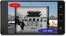
도5a 내지 도5c는 특정 대상에 대한 연대별 과거 영상 조회 화면에 관한 예시도.
도6은 과거 영상을 배경으로 하는 인물 촬영에 관한 예시도.
도7은 합성된 영상을 소셜 네트워크 서비스를 통해 공유하는 화면에 관한 예시도.
도8은 본 발명의 바람직한 실시 예에 따른 위치 기반 정보 서비스를 이용한 역사 정보 제공 방법에 관한 전체 흐름도.1 is an overall configuration diagram of a history information providing system using a location-based information service according to an embodiment of the present invention.
2 is a detailed block diagram of an image processing means according to a preferred embodiment of the present invention.
3 is an exemplary view of a specific target inquiry screen.
4A and 4B are exemplary views of a detailed description inquiry screen for a specific object.
5A to 5C are exemplary views of a past image inquiry screen for each specific age.
6 is an exemplary view of portrait photography with a background of a past image;
7 is an exemplary diagram of a screen for sharing a synthesized image through a social network service.
8 is a flowchart illustrating a history information providing method using a location based information service according to an exemplary embodiment of the present invention.
본 발명의 실시를 위한 구체적인 내용을 설명하기에 앞서, 본 명세서 및 청구범위에 사용된 용어나 단어는 발명자가 그 자신의 발명을 가장 최선의 방법으로 설명하기 위해 용어의 개념을 적절하게 정의할 수 있다는 원칙에 입각하여 본 발명의 기술적 사상에 부합하는 의미와 개념으로 해석되어야 할 것이다.Before describing the specific details for the practice of the invention, terms and words used in the specification and claims should be construed to enable the inventor to properly define the concept of a term in order to best describe its invention It should be interpreted as meaning and concept consistent with the technical idea of the present invention.
또한, 본 발명에 관련된 공지 기능 및 그 구성에 대한 구체적인 설명이 본 발명의 요지를 불필요하게 흐릴 수 있다고 판단되는 경우에는, 그 구체적인 설명을 생략하였음에 유의해야 할 것이다.
In addition, when it is determined that the detailed description of the known function and its configuration related to the present invention may unnecessarily obscure the subject matter of the present invention, it should be noted that the detailed description is omitted.
이하, 본 발명의 바람직한 실시 예에 따른 위치 기반 정보 서비스를 이용한 역사 정보 제공 시스템에 관해 도 1 내지 도 7을 참조하여 상세히 설명한다.Hereinafter, a history information providing system using a location based information service according to an exemplary embodiment of the present invention will be described in detail with reference to FIGS. 1 to 7.
도 1은 본 발명의 바람직한 실시 예에 따른 위치 기반 정보 서비스를 이용한 역사 정보 제공 시스템에 관한 전체 구성도이며, 도 2는 본 발명의 바람직한 실시 예에 따른 영상처리수단에 관한 상세 구성도이고, 도 3은 특정 대상 조회 화면에 관한 예시도이며, 도 4a 및 도 4b는 특정 대상에 대한 상세 설명 조회 화면에 관한 예시도이고, 도 5a 내지 도 5c는 특정 대상에 대한 연대별 과거 영상 조회 화면에 관한 예시도이며, 도 6은 과거 영상을 배경으로 하는 인물 촬영에 관한 예시도이고, 도 7은 합성된 영상을 소셜 네트워크 서비스를 통해 공유하는 화면에 관한 예시도이다.1 is an overall configuration diagram of a history information providing system using a location-based information service according to a preferred embodiment of the present invention, Figure 2 is a detailed configuration diagram of the image processing means according to a preferred embodiment of the present invention, 3 is an exemplary view of a specific object inquiry screen, FIGS. 4A and 4B are exemplary views of a detailed description inquiry screen for a specific object, and FIGS. 5A to 5C are examples of a past image inquiry screen for each specific object. FIG. 6 is a diagram illustrating a person photographing a background of a past image, and FIG. 7 is a diagram illustrating a screen for sharing a synthesized image through a social network service.
도 1에 도시한 바와 같이, 본 발명의 바람직한 실시 예에 따른 위치 기반 정보 서비스를 이용한 역사 정보 제공 시스템은, 역사정보제공서버(100), 3rd party DB 수집 엔진(200), 관리서버(300) 및 사용자단말기(400)를 포함한다.As shown in Figure 1, the history information providing system using a location-based information service according to an embodiment of the present invention, history information providing server 100, 3rd party DB
먼저, 역사정보제공서버(100)는 본 발명의 바람직한 실시 예에 따른 위치 기반 정보 서비스를 이용한 역사 정보 제공 서비스를 위하여 관리서버(300)로 역사 정보를 제공하는 기관의 서버로서, 국립 박물관 서버인 것이 바람직하나, 본 발명이 이에 한정되는 것은 아니다.First, the history information providing server 100 is a server of an institution that provides history information to the management server 300 for the history information providing service using a location-based information service according to an embodiment of the present invention, Preferably, but the present invention is not limited thereto.
역사정보제공서버(100)는 정기적으로 또는 수시로 각종 역사 정보를 관리서버(300)로 전송하며, 역사 정보는 특정 대상의 위치 정보와, 특정 대상별, 시기별 영상 정보를 포함한다.The history information providing server 100 transmits various kinds of historical information to the management server 300 regularly or at any time, and the history information includes location information of a specific object, image information for each specific object, and time.
본 발명에서, 특정 대상의 위치 정보는 사용자 인터페이스의 관점에서 POI(Point of Interest)로 표현된다.In the present invention, the location information of the specific object is expressed as a point of interest (POI) from the viewpoint of the user interface.
다음으로, 3rd party DB 수집 엔진(200)은 정기적으로 또는 수시로 공공 DB 또는 포털 사업자 DB를 수집하여 관리서버(300)로 전송하며, 특히 사용자단말기(400)의 요청에 따라 위치 정보, 특징점 또는 마커 등의 기준에 의해 공공 DB 또는 포털 사업자 DB를 조회하여 관련정보를 수집한다.Next, the 3rd party DB
3rd party DB 수집 엔진(200)이 수집하는 공공 DB 또는 포털 사업자 DB 정보는 역사정보제공서버(100)가 제공하는 역사 정보와 결합되어 본 발명의 바람직한 실시 예에 따라 제공되는 통합 역사 정보로서 기능한다.Public DB or portal operator DB information collected by the 3rd party DB
다음으로, 관리서버(300)는 본 발명의 바람직한 실시 예에 따른 위치 기반 정보 서비스를 이용한 역사 정보 제공 서비스를 제공하는 자의 서버로서, 특정 대상(POI)의 위치 정보와 특정 대상별, 시기별 영상 정보를 포함하는 역사 정보 데이터베이스와, 사용자 정보 데이터베이스를 가지고 있으며, 역사정보수신수단(310), 위치정보검색수단(320), 영상처리수단(330), 역사정보제공수단(340), 사용자관리수단(350), 서비스제어수단(360) 및 사용자정보공유수단(370)을 포함하여 구성된다.Next, the management server 300 is a server of a person providing a history information providing service using a location-based information service according to an embodiment of the present invention, the location information of a specific target (POI) and the image information for each specific target, time It has a history information database and a user information database, including the history information receiving means 310, location information search means 320, image processing means 330, history information providing means 340, user management means ( 350, the service control means 360 and the user information sharing means 370.
역사정보수신수단(310)은 역사정보제공서버(100)로부터 특정 대상의 위치 정보와 특정 대상별, 시기별 영상 정보를 포함하는 역사 정보를 수신한다.The history information receiving means 310 receives the history information including the location information of the specific object and the image information for each specific object and time from the history information providing server 100.
위치정보검색수단(320)은 영상처리수단(330)이 사용자단말기(400)로부터의 역사 정보 검색 요청을 수신함에 따라 사용자단말기(400)의 위치 정보를 검색함으로써 본 발명에 따른 서비스가 사용자의 위치를 이용할 수 있도록 한다.The location information retrieval means 320 retrieves the location information of the
위치정보검색수단(320)이 사용자단말기(400)의 위치 정보를 검색하는 방식으로는 다수의 방식을 채택할 수 있으나, 사용자단말기(400)로부터 수신한 위성의 위치좌표 및 사용자단말기(400)의 위치좌표를 이용하는 방식을 채택할 수 있다.Although the location information retrieval unit 320 may adopt a plurality of methods as a method for retrieving the location information of the
한편, 영상처리수단(330)은 사용자단말기(400)로부터의 역사 정보 검색 요청과 현재 카메라 입력 영상을 수신하며, 카메라 입력 영상과 POI의 시기별 영상을 합성함으로써 합성 영상을 생성한다.On the other hand, the image processing means 330 receives the history information search request from the
영상처리수단(330)의 합성 영상 생성에는 증강 현실(Augmented Reality, AR) 기술이 이용되는바, 증강 현실 기술은 현실 세계에 실시간으로 부가 정보를 가지는 가상 세계를 합성하여 하나의 영상으로 표현하는 기술이다.Augmented Reality (AR) technology is used to generate a composite image of the image processing means 330. The augmented reality technology is a technique for synthesizing a virtual world having additional information in real time in a real world and expressing it as one image. to be.
영상처리수단(330)은 공간보정수단(331), 데이터변환수단(332), 방위각계산수단(333) 및 영상합성수단(334)을 포함한다.The image processing means 330 includes a space correction means 331, data conversion means 332, azimuth calculation means 333, and image synthesizing means 334.
공간보정수단(331)은 사용자단말기(400)로부터 수신한 입력 영상의 현실 세계 좌표계와 시기별 POI 영상의 이미지 좌표계를 정합한다.The spatial correction means 331 matches the real world coordinate system of the input image received from the
데이터변환수단(332)은 위도 및 경도 기반의 좌표계 데이터를 증강 현실을 이용한 합성 영상에 적합한 데이터로 변환한다.The data conversion means 332 converts latitude and longitude-based coordinate system data into data suitable for a composite image using augmented reality.
방위각계산수단(333)은 사용자단말기(400)로부터 수신한 입력 영상을 분석하여 사용자단말기(400)의 방위각을 계산한다.The azimuth calculation unit 333 calculates an azimuth angle of the
영상합성수단(334)은 공간 보정 정보, 변환된 데이터 정보, 계산된 방위각 정보를 바탕으로 사용자단말기(400)로부터의 입력 영상과 시기별 POI 영상을 합성함으로써 합성 영상을 생성한다.The image synthesizing means 334 generates a composite image by synthesizing the input image from the
다음으로, 역사정보제공수단(340)은 사용자단말기(400)로부터 일정 거리 내에 존재하는 POI 정보를 사용자단말기(400)로 제공하며, 특정 POI에 대한 선택 신호를 사용자단말기(400)로부터 수신한 경우 특정 POI에 대한 상세 정보 및 특정 POI에 대한 합성 영상, 즉 사용자단말기(400)의 카메라 입력 영상과 시기별 POI 영상을 합성한 영상을 전송한다.Next, the history information providing means 340 provides the POI information existing within a predetermined distance from the
도 3을 참조하면, 사용자가 사용자단말기(400)의 어플리케이션을 구동하고 카메라를 작동시키면, 사용자단말기(400)로부터 일정 거리 내에 존재하는 POI 정보를 확인할 수 있다.Referring to FIG. 3, when a user drives an application of the
도 3에서, 사용자와 인접한 POI로서 인왕산, 세종문화회관, 광화문, 미국대사관 등을 확인할 수 있으며, 이는 해당하는 POI에 관한 정보가 관리서버(300)의 역사 정보 데이터베이스에 등록되어 있음을 의미한다.In FIG. 3, Inwangsan, Sejong Center, Gwanghwamun, US Embassy, etc. can be identified as POIs adjacent to the user, which means that information on the corresponding POI is registered in the history information database of the management server 300.
도 4a 및 도 4b를 참조하면, 사용자가 특정한 POI로서 예컨대 광화문을 선택하고 상세 설명 메뉴를 선택하면, 광화문에 대한 상세 설명을 확인할 수 있다.4A and 4B, when a user selects, for example, Gwanghwamun as a specific POI and selects a detailed description menu, the detailed description of Gwanghwamun can be checked.
도 5a 내지 도 5c를 참조하면, 사용자가 광화문에 대하여 박물관 가기 메뉴를 선택하면, 광화문에 대한 합성 영상을 확인할 수 있으며, 구체적으로는 현재의 배경 영상에 시기별 광화문 영상이 합성된 영상들을 조회할 수 있다.5A to 5C, when a user selects a museum go menu for Gwanghwamun, the composite image of Gwanghwamun can be checked, and specifically, images of time-sensitive Gwanghwamun images synthesized by the current background image can be queried. Can be.
합성되는 시기별 광화문 영상의 시기는 특별히 한정되지 아니하며 역사 정보 데이터베이스 등에서 추출할 수 있는 모든 시기별 광화문 영상의 합성 영상을 제공할 수도 있고, 사용자의 선택에 따라 특정 기간에 해당하는 시기별 광화문 영상의 합성 영상을 제공할 수도 있을 것이다.The timing of the synthesized Gwanghwamun images by time is not particularly limited, and may provide a composite image of all Gwanghwamun images by time, which can be extracted from a historical information database, or, depending on a user's selection, It may also provide a composite image.
도 6을 참조하면, 사용자가 광화문에 대하여 사진 촬영 메뉴를 선택하면, 광화문에 대한 합성 영상을 배경으로 하여 인물 사진 등을 촬영하여 여러 가지로 이용할 수 있게 된다.Referring to FIG. 6, when the user selects a photography menu for the Gwanghwamun gate, the user can take a picture of a person and the like using the composite image of the Gwanghwamun gate as a background and use it in various ways.
특히, 서울 지역의 경우 주요 도심이 과거로부터 계속적으로 이어져 내려오고 있으며, 남대문, 동대문 등 역사적으로 가치 있는 유산들이 다수 존재하므로 본 발명에 따른 역사 정보 제공 서비스 지역으로서 적합하다.In particular, in the case of Seoul area, the main city center has been continued from the past, and since there are many historically valuable heritages such as Namdaemun and Dongdaemun, it is suitable as a historical information providing service area according to the present invention.
상술한 바와 같이, 역사정보제공수단(340)이 제공하는 특정 POI에 대한 합성 영상 제공 기술은 특정 POI에 대해 각종 데이터베이스로부터 추출할 수 있는 다양한 시기별 영상을 포함하므로, 위치 기반 정보 서비스의 개념, 증강 현실의 개념, 시간적 흐름의 개념이 모두 결합하여 신규한 어플리케이션을 제공하는 기술이라 할 수 있다.As described above, the synthesis image providing technology for the specific POI provided by the history information providing means 340 includes various time-phase images that can be extracted from various databases for the specific POI, so that the concept of location-based information service, The concept of augmented reality and the concept of time flow combine to provide a new application.
다음으로, 사용자관리수단(350)은 사용자 계정을 관리하며, 구체적으로 사용자단말기(400)로부터 사용자 정보를 수신하여 갱신하며 갱신된 사용자 정보를 저장한다.Next, the user management means 350 manages a user account, specifically, receives and updates user information from the
갱신 대상이 되는 사용자 정보로는 사용자 계정 변경, 패스워드 변경 정보 등을 들 수 있을 것이다.The user information to be updated may include a user account change, password change information, and the like.
다음으로, 서비스제어수단(360)은 역사정보수신수단(310), 위치정보검색수단(320), 영상처리수단(330), 역사정보제공수단(340), 사용자관리수단(350) 및 사용자정보공유수단(370)을 제어함으로써 본 발명의 바람직한 실시 예에 따른 위치 기반 정보 서비스를 이용한 역사 정보 제공 서비스를 구현한다.Next, the service control means 360 is history information receiving means 310, location information search means 320, image processing means 330, history information providing means 340, user management means 350 and user information By controlling the sharing means 370 to implement a history information providing service using a location-based information service according to an embodiment of the present invention.
그리고 사용자정보공유수단(370)은 역사정보제공수단(340)에 의해 제공되는 특정 POI에 대한 합성 영상 및 상세 정보 등의 신규 콘텐츠를 소셜 네트워크 서비스(SNS)를 통해 다수 사용자에게 제공 및 공유시키며, 이러한 공유에 의한 정보는 임의의 POI 정보 획득 또는 갱신에서도 사용될 수 있다.In addition, the user information sharing means 370 provides and shares new content, such as a composite image and detailed information, for a specific POI provided by the history information providing means 340 to a plurality of users through a social network service (SNS), This sharing information can be used for obtaining or updating any POI information.
한편, 관리서버(300)가 보유하는 역사 정보 데이터베이스는 특정 대상(POI)의 위치 정보와 특정 대상별, 시기별 영상 정보를 포함하는 역사 정보를 저장하며 관련 정보가 갱신되는 경우 갱신된 관련 정보를 저장한다.Meanwhile, the history information database held by the management server 300 stores historical information including location information of a specific object (POI) and image information by specific object and time, and stores updated related information when the related information is updated. do.
아울러, 관리서버(300)가 보유하는 사용자 정보 데이터베이스는 사용자 정보를 저장하며 관련 정보가 갱신되는 경우 갱신된 관련 정보를 저장하고, 사용자 정보로는 사용자 계정, 패스워드 등이 있을 것이다.In addition, the user information database held by the management server 300 stores the user information, and if the related information is updated, the updated related information, and the user information may include a user account, password and the like.
추가적으로, 역사정보제공수단(340) 또는 사용자정보공유수단(370)은 3rd party 개발자 단말기(미도시)로 3rd party 개발자들을 위한 개발도구(Software Development Kit, SDK)를 배포하는 기능을 수행한다.Additionally, the history information providing means 340 or the user information sharing means 370 performs a function of distributing a development tool (Software Development Kit, SDK) for 3rd party developers to a 3rd party developer terminal (not shown).
배포되는 개발도구는 라이브러리, 관련 도큐멘트, 개발 툴을 포함하며, 이에 의해 3rd party 개발자들의 응용 소프트웨어 업데이트 참여를 독려할 수 있을 뿐만 아니라 관리서버(300)의 시스템을 채택하도록 하는 유인이 되는 효과가 있다.The development tools that are distributed include libraries, related documents, and development tools, thereby encouraging 3rd party developers to participate in application software updates as well as inducing the adoption of the system of the management server 300. .
다음으로, 사용자단말기(400)는 본 발명의 바람직한 실시 예에 따른 위치 기반 정보 서비스를 이용한 역사 정보 제공 서비스를 이용하는 자의 단말기로서, 일정 거리 내에 존재하는 POI 정보를 관리서버(300)로부터 수신하며, 특정 POI에 대한 선택 신호를 관리서버(300)로 전송하고, 특정 POI에 대한 상세 정보 및 특정 POI에 대한 합성 영상을 관리서버(300)로부터 수신한다.Next, the
사용자단말기(400)는 스마트폰 등의 모바일 단말기인 것이 바람직하며 다양한 사용자 인터페이스를 지원한다.The
한편, 사용자단말기(400)는 GNSS 수신기를 포함하는바, GNSS 수신기는 별도의 항법위성과 유선 또는 무선을 포함하는 인터넷망을 통해 접속되어 수신한 위성 궤도정보(Ephemeris)에 따라 위성의 위치좌표를 도출하고, 도출한 위성의 위치좌표를 토대로 사용자 위치좌표를 도출한다.
On the other hand, the
이하, 본 발명의 바람직한 실시 예에 따른 위치 기반 정보 서비스를 이용한 역사 정보 제공 방법에 관해 도 8을 참조하여 상세히 설명한다.Hereinafter, a method of providing history information using a location-based information service according to an exemplary embodiment of the present invention will be described in detail with reference to FIG. 8.
도 8은 본 발명의 바람직한 실시 예에 따른 위치 기반 정보 서비스를 이용한 역사 정보 제공 방법에 관한 전체 흐름도이다.8 is a flowchart illustrating a history information providing method using a location based information service according to an exemplary embodiment of the present invention.
먼저, 도 8에 도시한 바와 같이, 관리서버(300)가, 특정 대상(POI)의 위치 정보와 특정 대상별, 시기별 영상 정보를 포함하는 역사 정보를 역사정보제공서버(100)로부터 수신한다(S10).First, as shown in FIG. 8, the management server 300 receives the historical information from the history information providing server 100 including location information of a specific object (POI) and image information for each specific object and time (see FIG. 8). S10).
다음으로, 관리서버(300)가, 사용자단말기(400)의 위치 정보를 검색하며 사용자단말기(400)로부터 일정 거리 내에 존재하는 POI 정보를 사용자단말기(400)로 전송한다(S20).Next, the management server 300 retrieves the location information of the
다음으로, 관리서버(300)가, 특정 POI에 대한 선택 신호를 수신한 경우 특정 POI에 대한 합성 영상, 즉 사용자단말기(400)의 카메라 입력 영상과 시기별 특정 POI 영상을 합성한 영상을 생성한다(S30).Next, when the management server 300 receives a selection signal for a specific POI, the management server 300 generates a synthesized image for the specific POI, that is, an image obtained by synthesizing the camera input image of the
마지막으로, 관리서버(300)가, 특정 POI에 대한 상세 설명 정보 및 합성 영상을 사용자단말기(400)로 전송한다(S40).Finally, the management server 300 transmits the detailed description information and the composite image for the specific POI to the user terminal 400 (S40).
추가적으로, S10 단계 이전부터 S30 단계 이후 중 임의적으로 관리서버(300)가 사용자 계정, 패스워드 등을 포함하는 사용자 정보를 사용자단말기(400)로부터 수신하여 갱신하는 단계를 포함할 수 있다.Additionally, the management server 300 may optionally include receiving user information including a user account, a password, and the like from the
이상으로 본 발명의 기술적 사상을 예시하기 위한 바람직한 실시 예와 관련하여 설명하고 도시하였지만, 본 발명은 이와 같이 도시되고 설명된 그대로의 구성 및 작용에만 국한되는 것이 아니며, 기술적 사상의 범주를 일탈함이 없이 본 발명에 대해 다수의 변경 및 수정 가능함을 당업자들은 잘 이해할 수 있을 것이다. 따라서 그러한 모든 적절한 변경 및 수정과 균등물들도 본 발명의 범위에 속하는 것으로 간주하여야 할 것이다.While the present invention has been particularly shown and described with reference to preferred embodiments thereof, it will be understood by those skilled in the art that various changes in form and details may be made therein without departing from the spirit and scope of the invention as defined by the appended claims. It will be appreciated by those skilled in the art that numerous changes and modifications can be made without departing from the invention. Accordingly, all such modifications and variations are intended to be included within the scope of the present invention.
100 : 역사정보제공서버 200 : 3rd party DB 수집 엔진
300 : 관리서버 310 : 역사정보수신수단
320 : 위치정보검색수단 330 : 영상처리수단
331 : 공간보정수단 332 : 데이터변환수단
333 : 방위각계산수단 334 : 영상합성수단
340 : 역사정보제공수단 350 : 사용자관리수단
360 : 서비스제어수단 370 : 사용자정보공유수단
400 : 사용자단말기100: history information providing server 200: 3rd party DB collection engine
300: management server 310: history information receiving means
320: location information search means 330: image processing means
331: space correction means 332: data conversion means
333: azimuth calculation means 334: image synthesis means
340: history information providing means 350: user management means
360: service control means 370: user information sharing means
400: user terminal
Claims (5)
정기적으로 또는 수시로 특정 대상의 위치 정보와, 특정 대상별, 시기별 영상 정보를 포함하는 역사 정보를 관리서버(300)로 전송하는 역사정보제공서버(100);
사용자단말기(400)의 요청에 따라 공공 DB 또는 포털 사업자 DB를 수집하여 상기 관리서버(300)로 전송하는 3rd party DB 수집 엔진(200);
역사 정보를 상기 역사정보제공서버(100)로부터 수신하며, 상기 사용자단말기(400)의 위치 정보를 검색하여 상기 사용자단말기(400)로부터 일정 거리 내에 존재하는 특정 대상 정보를 상기 사용자단말기(400)로 전송하고, 상기 사용자단말기(400)로부터 특정 대상에 대한 선택 신호를 수신한 경우 상기 사용자단말기(400)의 카메라 입력 영상과 특정 대상의 시기별 영상을 합성한 합성 영상을 생성하여 상기 사용자단말기(400)로 전송하는 관리서버(300); 및
특정 대상 정보를 상기 관리서버(300)로부터 수신하며, 특정 대상에 대한 선택 신호를 상기 관리서버(300)로 전송하고, 특정 대상에 대한 합성 영상을 상기 관리서버(300)로부터 수신하는 사용자단말기(400);를 포함하는 위치 기반 정보 서비스를 이용한 역사 정보 제공 시스템.In the history information providing system using a location based information service,
A history information providing server 100 that periodically or occasionally transmits, to the management server 300, historical information including location information of a specific object and image information of a specific object and time;
A third party DB collection engine 200 which collects a public DB or portal operator DB according to a request of a user terminal 400 and transmits it to the management server 300;
Receives the historical information from the history information providing server 100, retrieves the location information of the user terminal 400 to the specific target information existing within a certain distance from the user terminal 400 to the user terminal 400 In case of receiving a selection signal for a specific object from the user terminal 400, the user terminal 400 generates a composite image obtained by synthesizing a camera input image of the user terminal 400 with a time-specific image of a specific object. Management server to transmit to; And
A user terminal receiving specific target information from the management server 300, transmitting a selection signal for a specific target to the management server 300, and receiving a composite image for a specific target from the management server 300 ( 400); history information providing system using a location-based information service comprising a.
상기 관리서버(300)는,
역사 정보를 상기 역사정보제공서버(100)로부터 수신하는 역사정보수신수단(310);
상기 사용자단말기(400)의 위치 정보를 검색하는 위치정보검색수단(320);
상기 사용자단말기(400)의 카메라 입력 영상과 특정 대상의 시기별 영상을 합성한 합성 영상을 생성하는 영상처리수단(330); 및
상기 사용자단말기(400)로부터 일정 거리 내에 존재하는 특정 대상 정보를 상기 사용자단말기(400)로 전송하고, 상기 사용자단말기(400)로부터 특정 대상에 대한 선택 신호를 수신한 경우 특정 대상에 대한 합성 영상을 상기 사용자단말기(400)로 전송하는 역사정보제공수단(340);을 포함하는 것을 특징으로 하는 위치 기반 정보 서비스를 이용한 역사 정보 제공 시스템.The method of claim 1,
The management server 300,
History information receiving means (310) for receiving history information from the history information providing server (100);
Location information retrieval means (320) for retrieving location information of the user terminal (400);
Image processing means 330 for generating a synthesized image obtained by synthesizing a camera input image of the user terminal 400 and an image of a specific target at a time; And
When the specific target information existing within a predetermined distance from the user terminal 400 is transmitted to the user terminal 400, and a selection signal for the specific target is received from the user terminal 400, a composite image of the specific target is output. History information providing system using a location-based information service, comprising; history information providing means for transmitting to the user terminal (400).
상기 영상처리수단(330)은,
상기 사용자단말기(400)로부터 수신한 입력 영상의 현실 세계 좌표계와 시기별 특정 대상 영상의 이미지 좌표계를 정합하는 공간보정수단(331);
위도 및 경도 기반의 좌표계 데이터를 증강 현실을 이용한 합성 영상에 적합한 데이터로 변환하는 데이터변환수단(332);
상기 사용자단말기(400)로부터 수신한 입력 영상을 분석하여 상기 사용자단말기(400)의 방위각을 계산하는 방위각계산수단(333); 및
공간 보정 정보, 변환된 데이터 정보 및 계산된 방위각 정보를 바탕으로 상기 사용자단말기(400)로부터의 입력 영상과 시기별 특정 대상 영상을 합성함으로써 합성 영상을 생성하는 영상합성수단(334);을 포함하는 것을 특징으로 하는 위치 기반 정보 서비스를 이용한 역사 정보 제공 시스템.The method of claim 2,
The image processing means 330,
Space correction means (331) for matching a real world coordinate system of the input image received from the user terminal 400 and an image coordinate system of a specific target image for each time period;
Data conversion means 332 for converting latitude and longitude-based coordinate system data into data suitable for a composite image using augmented reality;
Azimuth calculation means (333) for analyzing an input image received from the user terminal (400) to calculate an azimuth of the user terminal (400); And
Image synthesis means 334 for generating a composite image by synthesizing an input image from the user terminal 400 and a specific target image for each time based on the spatial correction information, the converted data information, and the calculated azimuth information. History information providing system using a location-based information service, characterized in that.
(A) 관리서버(300)가, 특정 대상의 위치 정보와 특정 대상별, 시기별 영상 정보를 포함하는 역사 정보를 역사정보제공서버(100)로부터 수신하는 단계;
(B) 상기 관리서버(300)가, 사용자단말기(400)의 위치 정보를 검색하며 상기 사용자단말기(400)로부터 일정 거리 내에 존재하는 특정 대상 정보를 상기 사용자단말기(400)로 전송하는 단계;
(C) 상기 관리서버(300)가, 특정 대상에 대한 선택 신호를 상기 사용자단말기(400)로부터 수신한 경우 상기 사용자단말기(400)의 카메라 입력 영상과 시기별 특정 대상 영상을 합성한 합성 영상을 생성하는 단계; 및
(D) 상기 관리서버(300)가, 특정 대상에 대한 합성 영상을 상기 사용자단말기(400)로 전송하는 단계;를 포함하는 위치 기반 정보 서비스를 이용한 역사 정보 제공 방법.In the history information providing method using a location based information service,
(A) the management server 300, receiving history information from the history information providing server 100 including location information of a specific object and image information for each specific object and time;
(B) the management server (300) searching for location information of the user terminal (400) and transmitting specific target information existing within a predetermined distance from the user terminal (400) to the user terminal (400);
(C) When the management server 300 receives a selection signal for a specific target from the user terminal 400, the management server 300 synthesizes a composite image obtained by synthesizing a camera input image of the user terminal 400 with a specific target image for each time period. Generating; And
(D) the management server 300, transmitting a composite image for a specific target to the user terminal 400; history information providing method using a location-based information service comprising a.
상기 (C) 단계는,
(C1) 상기 관리서버(300)가, 상기 사용자단말기(400)로부터 수신한 입력 영상의 현실 세계 좌표계와 시기별 특정 대상 영상의 이미지 좌표계를 정합하는 단계;
(C2) 상기 관리서버(300)가, 위도 및 경도 기반의 좌표계 데이터를 증강 현실을 이용한 합성 영상에 적합한 데이터로 변환하는 단계;
(C3) 상기 관리서버(300)가, 상기 사용자단말기(400)로부터 수신한 입력 영상을 분석하여 상기 사용자단말기(400)의 방위각을 계산하는 단계; 및
(C4) 상기 관리서버(300)가, 공간 보정 정보, 변환된 데이터 정보 및 계산된 방위각 정보를 바탕으로 상기 사용자단말기(400)로부터의 입력 영상과 시기별 특정 대상 영상을 합성함으로써 합성 영상을 생성하는 단계;를 포함하는 것을 특징으로 하는 위치 기반 정보 서비스를 이용한 역사 정보 제공 방법.5. The method of claim 4,
The step (C)
(C1) the management server 300 matching the real world coordinate system of the input image received from the user terminal 400 with the image coordinate system of the specific target image for each time;
(C2) the management server 300, converting latitude and longitude-based coordinate system data into data suitable for a composite image using augmented reality;
(C3) calculating, by the management server, the azimuth angle of the user terminal 400 by analyzing the input image received from the user terminal 400; And
(C4) the management server 300 generates a composite image by synthesizing the input image from the user terminal 400 and the specific target image for each time based on the spatial correction information, the converted data information, and the calculated azimuth information. History information providing method using a location-based information service comprising a.
Priority Applications (1)
| Application Number | Priority Date | Filing Date | Title |
|---|---|---|---|
| KR1020110135638A KR20130068463A (en) | 2011-12-15 | 2011-12-15 | System for providing history information using location based information service and the method |
Applications Claiming Priority (1)
| Application Number | Priority Date | Filing Date | Title |
|---|---|---|---|
| KR1020110135638A KR20130068463A (en) | 2011-12-15 | 2011-12-15 | System for providing history information using location based information service and the method |
Publications (1)
| Publication Number | Publication Date |
|---|---|
| KR20130068463A true KR20130068463A (en) | 2013-06-26 |
Family
ID=48864081
Family Applications (1)
| Application Number | Title | Priority Date | Filing Date |
|---|---|---|---|
| KR1020110135638A Abandoned KR20130068463A (en) | 2011-12-15 | 2011-12-15 | System for providing history information using location based information service and the method |
Country Status (1)
| Country | Link |
|---|---|
| KR (1) | KR20130068463A (en) |
Cited By (4)
| Publication number | Priority date | Publication date | Assignee | Title |
|---|---|---|---|---|
| KR101594071B1 (en) * | 2015-01-26 | 2016-02-16 | 동국대학교 산학협력단 | Apparatus and system for exhibition and method for providing exhibition data using the same |
| WO2019146830A1 (en) * | 2018-01-25 | 2019-08-01 | (주)이지위드 | Apparatus and method for providing real-time synchronized augmented reality content utilizing spatial coordinates as markers |
| KR20200111957A (en) * | 2019-03-20 | 2020-10-05 | 박주복 | Method and apparatus of generating virtual reality image |
| KR20200114832A (en) | 2019-03-29 | 2020-10-07 | 엠에스캠핑 주식회사 | System for providing local history and culture contents |
-
2011
- 2011-12-15 KR KR1020110135638A patent/KR20130068463A/en not_active Abandoned
Cited By (4)
| Publication number | Priority date | Publication date | Assignee | Title |
|---|---|---|---|---|
| KR101594071B1 (en) * | 2015-01-26 | 2016-02-16 | 동국대학교 산학협력단 | Apparatus and system for exhibition and method for providing exhibition data using the same |
| WO2019146830A1 (en) * | 2018-01-25 | 2019-08-01 | (주)이지위드 | Apparatus and method for providing real-time synchronized augmented reality content utilizing spatial coordinates as markers |
| KR20200111957A (en) * | 2019-03-20 | 2020-10-05 | 박주복 | Method and apparatus of generating virtual reality image |
| KR20200114832A (en) | 2019-03-29 | 2020-10-07 | 엠에스캠핑 주식회사 | System for providing local history and culture contents |
Similar Documents
| Publication | Publication Date | Title |
|---|---|---|
| US9906921B2 (en) | Updating points of interest for positioning | |
| JP5456799B2 (en) | Device transaction model and service based on device direction information | |
| US9874454B2 (en) | Community-based data for mapping systems | |
| KR101508076B1 (en) | Flexible data download models for augmented reality | |
| JP5711258B2 (en) | Method, apparatus, and computer program for performing location-specific information retrieval using a gesture-controlled handheld mobile device | |
| KR101016556B1 (en) | Method, server and computer readable recording medium for accessing a person's information using augmented reality | |
| JP5785302B2 (en) | A user portable terminal that retrieves target geographical information using the user's current position and current azimuth and provides the user with the information | |
| US11243288B2 (en) | Location error radius determination | |
| US20130095855A1 (en) | Method, System, and Computer Program Product for Obtaining Images to Enhance Imagery Coverage | |
| JP2012527053A (en) | Search system and method based on orientation | |
| CN102985901A (en) | Method and apparatus for rendering a perspective view of objects and content related thereto for location-based services on mobile device | |
| KR101413011B1 (en) | Augmented Reality System based on Location Coordinates and Augmented Reality Image Providing Method thereof | |
| KR20190059120A (en) | Facility Inspection System using Augmented Reality based on IoT | |
| EP3388958A1 (en) | Method and system for managing viewability of location-based spatial object | |
| KR20130068463A (en) | System for providing history information using location based information service and the method | |
| AU2008201380A1 (en) | Search system, management server, mobile communication device, search method, and program | |
| KR20190029412A (en) | Method for Providing Off-line Shop Information in Network, and Managing Server Used Therein | |
| JP4733343B2 (en) | Navigation system, navigation device, navigation method, and navigation program | |
| US20170220569A1 (en) | Method and system for constructing place database using crowdsourcing | |
| JP7065455B2 (en) | Spot information display system | |
| Naharudin et al. | GIS Data Collection for Pedestrian Facilities and Furniture Using MAPinr for Android | |
| WO2012093365A1 (en) | System for fusing geographic and locally acquired data for providing real world interoperability | |
| US20140004822A1 (en) | System and method for providing location-related information | |
| Arai | Pedestrian Navigation System with 3D Map and Charging Server Based on Steganography. | |
| WO2021090715A1 (en) | Information provision service program and information distribution device for information provision service |
Legal Events
| Date | Code | Title | Description |
|---|---|---|---|
| A201 | Request for examination | ||
| PA0109 | Patent application |
Patent event code: PA01091R01D Comment text: Patent Application Patent event date: 20111215 |
|
| PA0201 | Request for examination | ||
| E701 | Decision to grant or registration of patent right | ||
| PE0701 | Decision of registration |
Patent event code: PE07011S01D Comment text: Decision to Grant Registration Patent event date: 20130418 |
|
| PG1501 | Laying open of application | ||
| PC1904 | Unpaid initial registration fee |