KR101868819B1 - Methods of and Systems for Measuring Beacon Stability of Wireless Access Points - Google Patents
Methods of and Systems for Measuring Beacon Stability of Wireless Access Points Download PDFInfo
- Publication number
- KR101868819B1 KR101868819B1 KR1020137000681A KR20137000681A KR101868819B1 KR 101868819 B1 KR101868819 B1 KR 101868819B1 KR 1020137000681 A KR1020137000681 A KR 1020137000681A KR 20137000681 A KR20137000681 A KR 20137000681A KR 101868819 B1 KR101868819 B1 KR 101868819B1
- Authority
- KR
- South Korea
- Prior art keywords
- delete delete
- wireless device
- beacon
- likelihood
- designated wireless
- Prior art date
- Legal status (The legal status is an assumption and is not a legal conclusion. Google has not performed a legal analysis and makes no representation as to the accuracy of the status listed.)
- Expired - Fee Related
Links
Images


Classifications
-
- H—ELECTRICITY
- H04—ELECTRIC COMMUNICATION TECHNIQUE
- H04W—WIRELESS COMMUNICATION NETWORKS
- H04W4/00—Services specially adapted for wireless communication networks; Facilities therefor
- H04W4/02—Services making use of location information
-
- G—PHYSICS
- G01—MEASURING; TESTING
- G01S—RADIO DIRECTION-FINDING; RADIO NAVIGATION; DETERMINING DISTANCE OR VELOCITY BY USE OF RADIO WAVES; LOCATING OR PRESENCE-DETECTING BY USE OF THE REFLECTION OR RERADIATION OF RADIO WAVES; ANALOGOUS ARRANGEMENTS USING OTHER WAVES
- G01S5/00—Position-fixing by co-ordinating two or more direction or position line determinations; Position-fixing by co-ordinating two or more distance determinations
- G01S5/02—Position-fixing by co-ordinating two or more direction or position line determinations; Position-fixing by co-ordinating two or more distance determinations using radio waves
- G01S5/0278—Position-fixing by co-ordinating two or more direction or position line determinations; Position-fixing by co-ordinating two or more distance determinations using radio waves involving statistical or probabilistic considerations
-
- G—PHYSICS
- G01—MEASURING; TESTING
- G01S—RADIO DIRECTION-FINDING; RADIO NAVIGATION; DETERMINING DISTANCE OR VELOCITY BY USE OF RADIO WAVES; LOCATING OR PRESENCE-DETECTING BY USE OF THE REFLECTION OR RERADIATION OF RADIO WAVES; ANALOGOUS ARRANGEMENTS USING OTHER WAVES
- G01S1/00—Beacons or beacon systems transmitting signals having a characteristic or characteristics capable of being detected by non-directional receivers and defining directions, positions, or position lines fixed relatively to the beacon transmitters; Receivers co-operating therewith
- G01S1/02—Beacons or beacon systems transmitting signals having a characteristic or characteristics capable of being detected by non-directional receivers and defining directions, positions, or position lines fixed relatively to the beacon transmitters; Receivers co-operating therewith using radio waves
- G01S1/022—Means for monitoring or calibrating
- G01S1/024—Means for monitoring or calibrating of beacon transmitters
-
- G—PHYSICS
- G01—MEASURING; TESTING
- G01S—RADIO DIRECTION-FINDING; RADIO NAVIGATION; DETERMINING DISTANCE OR VELOCITY BY USE OF RADIO WAVES; LOCATING OR PRESENCE-DETECTING BY USE OF THE REFLECTION OR RERADIATION OF RADIO WAVES; ANALOGOUS ARRANGEMENTS USING OTHER WAVES
- G01S5/00—Position-fixing by co-ordinating two or more direction or position line determinations; Position-fixing by co-ordinating two or more distance determinations
- G01S5/02—Position-fixing by co-ordinating two or more direction or position line determinations; Position-fixing by co-ordinating two or more distance determinations using radio waves
- G01S5/0205—Details
- G01S5/021—Calibration, monitoring or correction
-
- G—PHYSICS
- G01—MEASURING; TESTING
- G01S—RADIO DIRECTION-FINDING; RADIO NAVIGATION; DETERMINING DISTANCE OR VELOCITY BY USE OF RADIO WAVES; LOCATING OR PRESENCE-DETECTING BY USE OF THE REFLECTION OR RERADIATION OF RADIO WAVES; ANALOGOUS ARRANGEMENTS USING OTHER WAVES
- G01S5/00—Position-fixing by co-ordinating two or more direction or position line determinations; Position-fixing by co-ordinating two or more distance determinations
- G01S5/02—Position-fixing by co-ordinating two or more direction or position line determinations; Position-fixing by co-ordinating two or more distance determinations using radio waves
- G01S5/0252—Radio frequency fingerprinting
-
- G—PHYSICS
- G01—MEASURING; TESTING
- G01S—RADIO DIRECTION-FINDING; RADIO NAVIGATION; DETERMINING DISTANCE OR VELOCITY BY USE OF RADIO WAVES; LOCATING OR PRESENCE-DETECTING BY USE OF THE REFLECTION OR RERADIATION OF RADIO WAVES; ANALOGOUS ARRANGEMENTS USING OTHER WAVES
- G01S5/00—Position-fixing by co-ordinating two or more direction or position line determinations; Position-fixing by co-ordinating two or more distance determinations
- G01S5/02—Position-fixing by co-ordinating two or more direction or position line determinations; Position-fixing by co-ordinating two or more distance determinations using radio waves
- G01S5/14—Determining absolute distances from a plurality of spaced points of known location
-
- H—ELECTRICITY
- H04—ELECTRIC COMMUNICATION TECHNIQUE
- H04W—WIRELESS COMMUNICATION NETWORKS
- H04W24/00—Supervisory, monitoring or testing arrangements
-
- H—ELECTRICITY
- H04—ELECTRIC COMMUNICATION TECHNIQUE
- H04W—WIRELESS COMMUNICATION NETWORKS
- H04W64/00—Locating users or terminals or network equipment for network management purposes, e.g. mobility management
Landscapes
- Engineering & Computer Science (AREA)
- Physics & Mathematics (AREA)
- General Physics & Mathematics (AREA)
- Radar, Positioning & Navigation (AREA)
- Remote Sensing (AREA)
- Computer Networks & Wireless Communication (AREA)
- Signal Processing (AREA)
- Probability & Statistics with Applications (AREA)
- Mobile Radio Communication Systems (AREA)
- Position Fixing By Use Of Radio Waves (AREA)
Abstract
무선 액세스 포인트의 비콘 안정도를 측정하기 위한 방법 및 시스템이 제공된다. 지정 무선 장치가 하나 이상의 이상 특성을 보일 우도의 측정치의 결정은, 지정 무선 장치와 관련된 기준 지점의 집합을 결정하고, 기준 지점의 속성, 지정 무선 장치와 관련된 다른 무선 장치와 관련된 속성 및/또는 통계적 정보를 검색함을 포함한다. 통계적 정보는 기준 지점의 신호의 검출 시간의 시간적 분포, 기준 지점의 공간적 분포 및/또는 집합 또는 기준 지점의 부분 집합의 기수를 포함한다. 상기 방법은 기준 지점의 속성, 신호의 수신과 관련된 속성 및/또는 통계적 정보를 근거로 하여, 지정 무선 장치가 하나 이상의 이상 특성을 나타낼 우도의 측정치의 결정을 추가로 포함한다. A method and system for measuring beacon stability of a wireless access point are provided. The determination of the measure of whether the designated wireless device will exhibit more than one anomaly is determined by determining the set of reference points associated with the designated wireless device and determining attributes of the reference point, attributes associated with the other wireless device associated with the designated wireless device, and / And searching for information. The statistical information includes the temporal distribution of the detection time of the signal at the reference point, the spatial distribution of the reference point, and / or the identity of the subset of the set or reference point. The method further includes determining a measure of likelihood that the designated wireless device will exhibit one or more of the characteristics based on the attributes of the reference point, the attributes associated with receiving the signal, and / or the statistical information.
Description
관련 출원의 상호 참조Cross reference of related application
본 출원은 35 U.S.C.§ 119(e)에 따라 아래의 출원들을 기초로 우선권을 주장하며, 이들 출원의 내용은 본원 명세서에 참조로 포함된다:This application claims priority under 35 U.S.C. § 119 (e), the contents of which are incorporated herein by reference:
미국 가특허출원 제61/353,936호[출원일: 2010년 06월 11일; 발명의 명칭: Methods of and Systems for Measuring Beacon Stability of Wireless Access Points] 및U.S. Provisional Patent Application No. 61 / 353,936 filed on June 11, 2010; &Quot; Methods of and Systems for Measuring Beacon Stability of Wireless Access Points "
미국 가특허출원 제61/440,940호[출원일: 2011년 02월 09일; 발명의 명칭: Methods of and Systems for Measuring Beacon Stability of Wireless Access Points].
*본 출원은 동일자로 출원된 아래의 출원들과 관련 있으며, 이들 출원의 내용은 본원 명세서에 참조로 포함된다:U.S. Provisional Patent Application No. 61 / 440,940 filed on Feb. 09, 2011; &Quot; Methods of and Systems for Measuring Beacon Stability of Wireless Access Points ".
This application is related to the following applications filed on the same basis as the present application, the contents of which are incorporated herein by reference:
삭제delete
미국 특허출원 번호 미정, Attorney Docket No. 2000319.176US1, 발명의 명칭 Systems for and Methods of Determining Likelihood of Mobility of Reference Points in a Positioning System,U. S. Patent Application No. U.S. Pat. No. Attorney Docket No. Systems , 2000319.176US1 for and Methods of Determining Likelihood of Mobility of Reference Points in a Positioning System ,
미국 특허출원 번호 미정, Attorney Docket No. 2000319.177US1, 발명의 명칭 Systems for and Methods of Determining Likelihood of Relocation of Reference Points in a Positioning System, U. S. Patent Application No. U.S. Pat. No. Attorney Docket No. Systems , 2000319.177US1 for and Methods of Determining Likelihood of Relocation of Reference Points in a Positioning System ,
미국 특허 출원 번호 미정, Attorney Docket No. 2000319.178US1, 발명의 명칭 Systems for and Methods of Determining Likelihood of Reference Point Identity Duplication in a Positioning System; 및 U. S. Patent Application No. U.S. Pat. No. Attorney Docket No. Systems , 2000319.178US1 for and Methods of Determining Likelihood of Reference Point Identity Duplication in a Positioning System ; And
미국 특허출원 번호 미정, Attorney Docket No. 2000319.179US1, 발명의 명칭 Systems for and Methods of Determining Likelihood of Atypical Transmission Characteristics of Reference Points in a Positioning System. U. S. Patent Application No. U.S. Pat. No. Attorney Docket No. Systems , 2000319.179US1 for and Methods of Determining Likelihood of Atypical Transmission Characteristics of Reference Points in a Positioning System .
발명의 배경기술BACKGROUND OF THE INVENTION
발명의 분야Field of invention
본 발명은 일반적으로 포지셔닝 시스템(positioning system)에 의한 위치 추정에 관한 것이며, 보다 구체적으로는, 기준 지점이 신뢰할 수 없고/없거나 기만하는 포지셔닝 정보를 산출할 수 있으며, 그리고 일부의 경우, 포지셔닝 정보를 위해 의존돼서는 안됨을 나타내는 포지셔닝 시스템의 기준 지점의 특징의 식별(identification) 및/또는 정량화(quantification)에 관한 것이다. The present invention relates generally to position estimation by a positioning system, and more particularly, to a method and apparatus that can generate positioning information in which a reference point is unreliable and / or deceptive, and in some cases, And / or < / RTI > quantification of the features of the reference point of the positioning system, which indicates that it should not be dependent on the user.
관련 기술의 설명Description of Related Technology
최근 들어, 모바일 및 휴대용 통신 및 컴퓨팅 장치는 어디에나 있으며(ubiquitous), 무선 통신 시스템은 연결성을 위해 대응하는 수요를 충족하도록 확장되었다. 모바일 및 휴대용 장치는 어떠한 고정적 위치도 갖지 않으며, 종종 이들의 사용자가 이동할 때, 동반하고, 애플리케이션 개발자는 애플리케이션을 실행하는 모바일 장치의 위치를 기초로 업데이트되거나 적응되는 애플리케이션을 만드는 기회에 집중하였다. 이해하기 쉬운 예로는 장치의 현재 위치를 가리키도록 업데이트되는 지도(map), 또는 특정 관심 지점(point of interest)의 근접도를 기초로 적응되는 광고가 있다. In recent years, mobile and portable communication and computing devices have been ubiquitous, and wireless communication systems have been extended to meet the corresponding needs for connectivity. Mobile and portable devices have no fixed location and are often accompanied when their users are traveling and application developers have focused on the opportunity to make applications that are updated or adapted based on the location of the mobile device running the application. An easy-to-understand example is a map that is updated to point to the current location of the device, or an ad that is adapted based on the proximity of a particular point of interest.
위치 인지형 애플리케이션(location-aware application)을 활성화시키기 위해, 장치 제조자는 최소 사용자 입력으로 그들의 장치가 위치 정보를 획득할 수 있도록 해야 한다. 규제 전선에서, FCC 강화된 911 법은 911 콜이 걸릴 때 모바일 전화기가 위치 정보를 응급 대원에게 제공할 수 있어야 한다고 규정한다. 장치 포지셔닝의 문제에 대한 종래의 해결책은 미리 정해진 궤도를 정밀하게 따르는 위성으로부터의 송신을 이용하는 GPS이다. 불행하게도, GPS는 종종 실내와 밀집된 도시 지역을 커버하지 못하며, 전용 하드웨어를 필요로 하고, 종종 느린 초기 위치 결정 시간(time to first fix)을 단점으로 가진다. 따라서 점점 더 많은 위치 결정 시스템이 IEEE 802.11 액세스 포인트 및 셀룰러 기지국과 같은 "기회의 비콘(beacons of opportunity)"을 기반으로 한다. 이들은 모바일 장치의 표준 하드웨어에 의해 수신되는 기존 무선 통신 시스템으로부터의 송신을 이용하고, 이를 비콘에 대해 알려진 정보와 조합하여, 모바일 장치의 위치를 결정할 수 있다. 이러한 시스템은 빠른 초기 위치 결정 시간을 제공하고 어떠한 전용 하드웨어도 필요로 하지 않으면서, GPS 커버리지 영역을 효과적으로 보완한다. To activate a location-aware application, the device manufacturer must enable their device to obtain location information with minimal user input. On the regulated front, the FCC enhanced 911 law stipulates that mobile phones should be able to provide location information to emergency personnel when a 911 call takes place. A conventional solution to the problem of device positioning is GPS, which uses transmissions from satellites that precisely follow predetermined trajectories. Unfortunately, GPS often does not cover indoor and dense urban areas, requires dedicated hardware, and often has a disadvantage of slow initial time to first fix. Thus, more and more positioning systems are based on " beacons of opportunity " such as IEEE 802.11 access points and cellular base stations. They can use transmissions from existing wireless communication systems that are received by standard hardware of the mobile device and combine them with information known about beacons to determine the location of the mobile device. These systems provide fast initial positioning time and effectively complement the GPS coverage area without requiring any dedicated hardware.
현재, 연구 커뮤니티와 상업 및 산업적 부문 모두에 많은 비콘 기반 포지셔닝 시스템(beacon-based positioning system)이 존재하며, 이들은 패턴 매칭(지문인식(fingerprinting)이라고도 알려짐)을 이용하는 것과 알려진 기준 지점까지의 거리 추정치를 이용하는 것으로 크게 나누어질 수 있다. 플레이스랩(Placelab) 및 기타에 의해 개발된 것과 같은 패턴 매칭 포지셔닝 방법("Practical Metropolitan-Scale Positioning for GSM Phones", Chen et al.)은 이의 관측치(observation)를 해당 지역에서 수집된 수신 신호 값의 지도에 매칭함으로써 클라이언트 장치의 위치를 추정한다.Currently, there are many beacon-based positioning systems in both the research community and the commercial and industrial sectors, which use pattern matching (also known as fingerprinting) and estimate the distance to a known reference point And can be roughly divided into use. A pattern matching positioning method such as that developed by Placelab et al. (&Quot; Practical Metropolitan-Scale Positioning for GSM Phones ", Chen et al.) Uses an observation of its received signal value And estimates the location of the client device by matching the map.
이와는 달리, 거리 추정치를 이용하는 시스템은 비콘으로부터 수신된 신호 강도의 패턴을 단순히 맵핑하기보다는 비콘 위치를 명시적으로 추정한다. 그 후, 이러한 시스템은, 신호 전파 시간 또는 수신된 신호 강도(RSS)를 근거로 하여, 클라이언트 장치에서부터 관측되는 비콘까지의 거리(range)를 추정한다.Alternatively, the system using the distance estimate explicitly estimates the beacon location rather than simply mapping the pattern of received signal strength from the beacon. This system then estimates the range from the client device to the observed beacon based on the signal propagation time or the received signal strength (RSS).
시간 기반 시스템은 신호의 송신과 수신 사이의 시간의 측정치를 이용하여, 송신기와 수신기 사이의 거리를 추정한다. 이러한 시스템은 도착시간(TOA: time of arrival), 또는 도착 시간차(TDOA: time-difference of arrival) 스킴을 이용하여, 사용자에게 위치 추정치를 발생시키기 위한 다양한 알고리즘에서 사용되기 위한 거리 추정치를 생성한다[참고: 슈흐만(Schuchman) 등의 미국 재발급 특허 제38,808호; 루우투(Ruutu) 등의 미국 공개특허공보 제2002/007715 A1호]. 그러나 GSM 및 UMTS과 같은 비동기식 시스템에서, 추가적인 기기가 상당한 추가 비용으로 각각의 셀에 설치된다[참고: 드레인(Drane) 등의 미국 특허공보 제6,275,705 B1호; 달만(Dahlman) 등의 미국 특허공보 제6,526,039 B1호; 미르(Myr)의 미국 특허공보 제6,901,264 B2호]. The time-based system estimates the distance between the transmitter and the receiver using a measure of the time between transmission and reception of the signal. This system uses the time of arrival (TOA) or time-difference of arrival (TDOA) scheme to generate a distance estimate for use in various algorithms to generate a position estimate for the user Reference: US Reissue Patent No. 38,808 by Schuchman et al .; U.S. Patent Publication No. 2002/007715 A1 to Ruutu et al.). However, in asynchronous systems such as GSM and UMTS, additional devices are installed in each cell at significant additional cost (see, for example, Drane et al., U.S. Patent No. 6,275,705 B1; Dahlman et al., U.S. Patent No. 6,526,039 B1; Myr, U.S. Patent No. 6,901,264 B2].
모바일에서부터 송신 비콘까지의 거리를 추정하기 위해 수신된 신호 강도(RSS)를 이용하는 시스템은 RSS가 송신기에서부터 수신기까지의 거리와 큰 관련성이 있다는 사실을 이용한다[참고: Zhu and Durgin, "Indoor/Outdoor Location of Cellular Handsets Based on Received Signal Strength"]. 잘 알려진 패스로스 모델(pathloss model)이 신호 파워가 거리에 따라 기하급수적으로 낮아짐을 보여주며, 따라서 패스로스 지수(pathloss exponent) 및 안테나 게인(antenna gain) 및 송신 파워와 같은 그 밖의 다른 파라미터에 대한 지식에 의해 포지셔닝 시스템은 거리 추정치(range estimate)를 계산할 수 있다. 몇 가지 잘 알려진 비콘 기반 포지셔닝 시스템이 이러한 방식, 특히, IEEE 802.11 액세스 포인트를 근거로 하는 Wi-Fi 포지셔닝(WPS: Wi-Fi positioning)의 형태로 된 것을 이용한다. A system using received signal strength (RSS) to estimate the distance from the mobile to the transmission beacon exploits the fact that RSS is highly related to the distance from the transmitter to the receiver [Zhu and Durgin, " Indoor / Outdoor Location of Cellular Handsets Based on Received Signal Strength ". The well-known pathloss model shows that the signal power drops exponentially with distance, and thus the pathloss exponent and other parameters such as antenna gain and transmit power By knowledge, the positioning system can calculate a range estimate. Several well-known beacon-based positioning systems use this approach, in particular in the form of Wi-Fi positioning (WPS) based on IEEE 802.11 access points.
발명의 간단한 요약A brief summary of the invention
한 가지 양상(aspect)에 있어서, 본 발명은 무선 액세스 포인트의 비콘 안정도를 측정하기 위한 방법 및 시스템을 제공한다. In one aspect, the present invention provides a method and system for measuring beacon stability of a wireless access point.
본 발명의 다른 양상에 있어서, 지정 무선 장치가 하나 이상의 이상 특성(pathological characteristic)을 나타낼 우도의 측정치를 결정하는 방법에 있어서, 상기 이상 특성은, 지정 무선 장치가 위치 추정 시스템에서의 랜드마크(landmark)로서 사용될 때, 그러한 이상 특성이 수정되지 않은 채 남아 있는 경우, 위치 추정에서 에러(error)의 발생을 야기하며, 상기 방법은 지정 무선 장치와 관련된 하나 이상의 기준 지점의 집합을 결정하는 단계를 포함한다. 상기 기준 지점 중 하나 이상은 지정 무선 장치로부터의 신호가 검출된 지리적 위치(i) 및 지정 무선 장치로부터의 신호가 수신기에 의해 검출된 선택된 시간 주기 이내에 수신기에 의해 신호가 검출된 다른 무선 장치 (ii) 중 적어도 하나이다. 상기 방법은 또한 집합의 기준 지점의 속성(i), 선택된 시간 주기 이내에 지정 무선 장치 및 또 다른 무선 장치로부터의 신호의 수신과 관련된 속성(ii) 및 통계적 정보(iii)를 검색(retrieving)하는 단계를 포함하며, 통계적 정보는 다음 중 적어도 하나에 대한 것이다: 집합의 기준 지점의 신호의 검출 시간의 시간적 분포, 기준 지점의 공간적 분포, 및 집합, 또는 기준 지점의 적어도 하나의 부분 집합의 기수(基數; cardinality). 상기 방법은 기준 지점의 속성(i), 신호의 수신과 관련된 속성(ii) 및 통계적 정보(iii) 중 적어도 하나를 근거로 하여, 지정 무선 장치가 하나 이상의 이상 특성을 나타낼 우도의 측정치를 결정하는 단계를 추가로 포함한다. In another aspect of the invention, a method is provided for determining a measure of likelihood that a designated wireless device will exhibit one or more pathological characteristics, the abnormal characteristic comprising at least one of a landmark When such an abnormal characteristic remains unmodified, causes an occurrence of an error in the position estimation, the method comprising the step of determining a set of one or more reference points associated with the designated wireless device do. Wherein at least one of the reference points comprises a geographical location (i) where a signal from the designated radio device is detected and another radio device in which the signal from the designated radio device is detected by the receiver within a selected time period detected by the receiver ). The method also includes retrieving attribute (i) of the set of reference points, attribute (ii) and statistical information (iii) associated with receiving a signal from the designated wireless device and another wireless device within the selected time period Wherein the statistical information is for at least one of the following: a temporal distribution of the detection time of the signal at the reference point of the set, a spatial distribution of the reference point, and a set of at least one subset of the set, cardinality). The method includes determining a measure of likelihood that the designated wireless device will exhibit one or more abnormal characteristics based on at least one of the attribute (i) of the reference point, the attribute (ii) associated with receiving the signal, and the statistical information (iii) . ≪ / RTI >
본 발명의 또 다른 양상에 있어서, 우도의 측정치는 이진 결정(binary decision)이다.In another aspect of the invention, the measure of likelihood is a binary decision.
본 발명의 또 다른 양상에 있어서, 우도의 측정치는 지정 무선 장치가 하나 이상의 이상 특성을 나타내는 확률의 상대적 측정치이다. In yet another aspect of the present invention, the measure of likelihood is a relative measure of the probability that the designated wireless device exhibits one or more anomalous characteristics.
본 발명의 또 다른 양상에 있어서, 상기 방법은, 다른 무선 장치가 지정 무선 장치와의 관계를 갖는 것을 근거로 하여, 지정 무선 장치가 아닌 다른 무선 장치가 하나 이상의 이상 특성을 나타낼 우도의 측정치를 결정하는 단계를 추가로 포함한다. 관계의 존재 여부는 지정 무선 장치와 다른 무선 장치가 소정의 시간 주기 이내에 동일한 위치의 신호 수신 범위 내에 있음을 근거로 한다. In another aspect of the present invention, the method determines a measure of likelihood that a wireless device other than the designated wireless device exhibits one or more abnormal characteristics, based on the fact that the other wireless device has a relationship with the designated wireless device . ≪ / RTI > The presence of the relationship is based on the fact that the designated wireless device and the other wireless device are within the signal reception range of the same position within a predetermined time period.
본 발명의 또 다른 양상에 있어서, 지정 무선 장치는 제1 식별자를 구비하고, 상기 방법은, 제1 식별자와 제2 지정 무선 장치와 관련된 제2 식별자와의 비교를 근거로 하여, 제2 지정 무선 장치가 하나 이상의 이상 특성을 나타낼 우도의 제2 측정치를 결정하는 단계를 추가로 포함한다.In another aspect of the present invention, a designated radio apparatus comprises a first identifier, the method comprising the steps of: determining, based on a comparison of a first identifier with a second identifier associated with a second designated radio, Further comprising determining a second measure of likelihood that the device will exhibit one or more anomalous characteristics.
본 발명의 또 다른 양상에 있어서, 하나 이상의 이상 특성은, 지정 무선 장치가 고정된 지리적 위치를 갖지 않는 이동형 장치(mobile device)인 것을 포함한다.
본 발명의 또 다른 양상에 있어서, 하나 이상의 이상 특성은, 지정 무선 장치가 지정 무선 장치와 일치하는 유형의 무선 장치의 비전형적인 신호 송신 특성을 보이는 것을 포함한다. In another aspect of the present invention, the one or more abnormal characteristics include that the designated wireless device is a mobile device that does not have a fixed geographic location.
In yet another aspect of the present invention, the one or more abnormal characteristics include showing the non-typical signal transmission characteristics of a type of wireless device with which the designated wireless device coincides with the designated wireless device.
삭제delete
본 발명의 또 다른 양상에 있어서, 하나 이상의 이상 특성은, 지정 무선 장치와 관련된 위치 정보가 무선 장치의 정확한 현재 위치가 아닌 것을 포함한다. In another aspect of the present invention, the one or more anomalies include that the location information associated with the designated wireless device is not the correct current location of the wireless device.
본 발명의 또 다른 양상에 있어서, 하나 이상의 이상 특성은, 지정 무선 장치와 관련된 식별자가 적어도 하나의 또 다른 무선 장치와도 관련되는 것을 포함한다. In another aspect of the present invention, the one or more abnormal characteristics include that the identifier associated with the designated wireless device is associated with at least one other wireless device.
본 발명의 또 다른 양상에 있어서, 지정 무선 장치는 식별자를 구비하고, 상기 방법은, 참조 데이터베이스에서, 식별자를 우도의 측정치의 표시와 연관시키는 단계를 추가로 포함한다. In another aspect of the invention, the designated wireless device comprises an identifier, and the method further comprises, in the reference database, associating the identifier with an indication of a measure of likelihood.
본 발명의 또 다른 양상에 있어서, 지정 무선 장치는 WiFi 가능형 액세스 포인트이다. In another aspect of the present invention, the designated wireless device is a WiFi capable access point.
본 발명의 또 다른 양상에 있어서, 지정 무선 장치는 이동형 전화기 송수신기 장치이다. In another aspect of the invention, the designated radio device is a mobile telephone transceiver device.
본 발명의 또 다른 양상에 있어서, 집합 중, 또 다른 무선 장치인 기준 지점에 대하여, 집합의 또 다른 무선 장치는 WiFi 가능형 액세스 포인트 및 이동형 전화기 송수신기 장치 중 적어도 하나이다. In another aspect of the invention, for a reference point that is another wireless device in the set, another wireless device in the set is at least one of a WiFi enabled access point and a mobile phone transceiver device.
본 발명의 또 다른 양상에 있어서, 집합의 기준 지점의 속성은 집합의 기준 지점의 추정 지리적 위치를 특정하는 위치 정보를 포함한다. 상기 방법은 또한 대응하는 기준 지점의 위치 정보를 근거로 하여, 집합의 각각의 기준 지점을 적어도 하나의 기준 지점의 클러스터로 그룹화하는 단계, 및 각각의 클러스터에 대하여, 집합의 기준 지점의 속성(i) 및 선택된 시간 주기 이내에 지정 무선 장치 및 또 다른 무선 장치로부터의 신호의 수신과 관련된 속성(ii) 중 적어도 하나를 근거로 하여, 클러스터의 속성을 결정하는 단계를 추가로 포함한다. 상기 방법은 또한 적어도 하나의 클러스터의 속성을 추가로 근거로 하는, 우도의 측정치를 결정하는 단계를 포함한다. In another aspect of the present invention, the attribute of the set of reference points includes position information that specifies an estimated geographic position of the set of reference points. The method also includes grouping each reference point of the set into clusters of at least one reference point based on position information of the corresponding reference point, and for each cluster, ) And attributes (ii) associated with receiving a signal from the designated wireless device and another wireless device within a selected time period. ≪ Desc / Clms Page number 12 > The method also includes determining a measure of likelihood based further on attributes of the at least one cluster.
본 발명의 또 다른 양상에 있어서, 지정 무선 장치가 하나 이상의 이상 특성을 나타낼 우도의 측정치를 결정하는 시스템에 있어서, 이상 특성은, 지정 무선 장치가 위치 추정 시스템에서의 랜드마크로서 사용될 때, 그러한 이상 특성이 수정되지 않은 채 남아 있는 경우, 위치 추정에서 에러의 발생을 야기하며, 상기 시스템은 컴퓨터 판독형 매체를 포함하고, 컴퓨터 판독형 매체는 컴퓨터 시스템에 의해 실행될 때 컴퓨터 시스템으로 하여금 앞서 언급된 방법 중 임의의 것을 수행하도록 하는 명령을 포함한다. In another aspect of the invention, a system is provided for determining a measure of likelihood that a designated wireless device will exhibit one or more anomalies, wherein the anomalous property is such that when the designated radio is used as a landmark in a position estimation system, Wherein the system comprises a computer readable medium and wherein the computer readable medium when executed by the computer system causes the computer system to perform the method as described above To perform any of the following.
본원 명세서에 언급된 형태들 중 임의의 형태가 본원 명세서에 개시된 실시예들 중 임의의 실시예와 함께 조합되어 사용될 수 있다. Any of the forms mentioned herein may be used in combination with any of the embodiments disclosed herein.
도 1은 스캔 관측의 일례를 도시한다.
도 2는 비콘들 사이의 관계의 그래프 표현의 예시적 일례를 도시한다.
도 3은 하나의 위치에서 또 다른 위치로 이동하는 비콘의 개념을 도시한다.
도 4는 초과 범위(excess range)를 갖는 비콘의 개념을 도시한다.
도 5는 비콘 재배치를 검출하는 방법을 도시한다.
도 6은 비콘을 공간적으로 클러스터링하는 방법을 도시한다.
도 7은 비콘 재배치를 검출하는 추가의 방법을 도시한다.
도 8은 비콘 재배치를 검출하는 또 다른 방법을 도시한다.
도 9는 비콘 재배치를 검출하는 또 다른 방법을 도시한다.
도 10은 비콘 재배치를 검출하는 또 다른 방법을 도시한다.
도 11은 비콘 재배치를 검출하는 또 다른 방법을 도시한다.
도 12는 비콘 재배치를 검출하는 방법을 도시한다.
도 13은 비콘에 대한 클러스터링 방법을 도시한다.
도 14는 비콘 재배치를 검출하는 또 다른 방법을 도시한다.
도 15는 비콘 그래프를 구축하는 방법을 도시한다.
도 16은 이동성을 보이는 비콘을 검출하는 방법을 도시한다.
도 17은 이동성을 보이는 비콘을 검출하는 또 다른 방법을 도시한다.
도 18은 이동성을 보이는 비콘을 검출하는 또 다른 방법을 도시한다.
도 19는 이동성을 보이는 비콘을 검출하는 또 다른 방법을 도시한다.
도 20은 편재성을 보이는 비콘을 검출하는 방법을 도시한다.
도 21은 편재성을 보이는 비콘을 검출하는 또 다른 방법을 도시한다.
도 22는 편재성을 보이는 비콘을 검출하는 또 다른 방법을 도시한다.
도 23은 편재성을 보이는 비콘을 검출하는 또 다른 방법을 도시한다.
도 24는 초과 범위를 보이는 비콘을 검출하는 방법을 도시한다.
도 25는 스캔들(scans)의 집합의 공간적 크기를 결정하기 위한 방법을 도시한다.
도 26은 초과 범위를 보이는 비콘을 검출하는 또 다른 방법을 도시한다.
도 27은 초과 범위를 보이는 비콘을 검출하는 또 다른 방법을 도시한다.Figure 1 shows an example of a scan observation.
Figure 2 shows an illustrative example of a graphical representation of the relationship between beacons.
Figure 3 shows the concept of a beacon moving from one position to another.
Figure 4 shows the concept of a beacon with an excess range.
Figure 5 shows a method for detecting beacon relocation.
Figure 6 illustrates a method for spatially clustering beacons.
Figure 7 illustrates an additional method of detecting beacon relocation.
Figure 8 illustrates another method for detecting beacon relocation.
Figure 9 illustrates another method for detecting beacon relocation.
Figure 10 illustrates another method for detecting beacon relocation.
Figure 11 shows another method for detecting beacon relocation.
Figure 12 shows a method for detecting beacon relocation.
Figure 13 shows a clustering method for beacons.
Figure 14 shows another method for detecting beacon relocation.
FIG. 15 shows a method for constructing a beacon graph.
16 shows a method of detecting beacons showing mobility.
FIG. 17 shows another method for detecting beacons showing mobility.
Figure 18 shows another method of detecting beacons showing mobility.
Figure 19 shows another method for detecting beacons showing mobility.
20 shows a method of detecting a beacon showing a ubiquitous property.
FIG. 21 shows another method of detecting a beacon exhibiting ubiquitousness.
22 shows another method of detecting a beacon exhibiting ubiquitousness.
Fig. 23 shows another method of detecting a beacon exhibiting ubiquitousness.
Fig. 24 shows a method for detecting a beacon showing an overrange.
Figure 25 illustrates a method for determining the spatial size of a collection of scans.
Fig. 26 shows another method of detecting beacons having an overrange.
Fig. 27 shows another method for detecting beacons showing an overrange.
실시예들은 IEEE 802.11 액세스 포인트와 같은 무선 통신 장치를 휴대전화기, 노트북 컴퓨터, 태블릿 컴퓨터, 게임용 시스템 및 그 밖의 다른 무선 통신 가능 장치(wireless-enabled device)와 같은 클라이언트 장치의 위치를 추정하기 위한 기준 지점으로서 사용하는 것과 관련된다. 본원 명세서에서, 비콘(beacon)이라는 단어는 포지셔닝을 위한 기준 지점(또는 랜드마크)으로서 사용되는 무선 통신 장치를 지칭하도록 사용된다. 이러한 포지셔닝 시스템은 비콘 속성(beacon attribute)의 데이터베이스의 생성과 유지 관리를 필요로 한다. 이동하거나 그 밖의 다른 방식으로 정확한 특징화가 불가능한 비콘[본원 명세서에서 이상 비콘(pathological beacon)이라고 함]은, 클라이언트 장치의 위치를 추정할 때, 큰 오류를 초래할 수 있으며, 따라서 이러한 비콘은 검출되고 데이터베이스에서 수정되어야 한다. 본 발명의 구현예는 이상 비콘을 검출하기 위한 방법을 제공한다. Embodiments relate to a wireless communication device, such as an IEEE 802.11 access point, as a reference point for estimating the location of a client device, such as a mobile phone, a notebook computer, a tablet computer, a gaming system, and other wireless- Lt; / RTI > In the present specification, the word beacon is used to refer to a wireless communication device used as a reference point (or landmark) for positioning. Such a positioning system requires the creation and maintenance of a database of beacon attributes. A beacon (herein referred to as a pathological beacon) that is unable to be accurately characterized in terms of moving or otherwise can cause a large error when estimating the location of the client device, . An embodiment of the present invention provides a method for detecting abnormal beacons.
용어 "기준 지점"은 본원 명세서에서 사용될 때, 비콘뿐만 아니라 비콘에 대한 안정도 측정치(stability measure)를 결정할 때 사용되는 지점 및/또는 그 밖의 다른 장치를 지칭한다. 이는 이하에서 보다 더 상세하게 제공된다. The term " reference point " as used herein refers to a point and / or other device used when determining a stability measure for a beacon as well as a beacon. This is provided in more detail below.
본 발명의 하나의 양상하에서, 비콘이 다양한 이상상태(pathology) 중 하나 이상을 나타낼 우도를 정량화하기 위한 뚜렷한 이상 비콘 거동, 관측치 및 방법이 정의된다. 본원 명세서에서 기재할 때, 이들 우도는 "확률(probability)"이라고 일컬어지며, 이는 정식 확률 추정치뿐만 아니라 그 밖의 다른 상대적 우도의 표현까지 포함할 수 있다. 개별적인 이상상태 확률이 하나의 비콘의 전반적인 안정도 및 신뢰성을 결정하는 이상상태의 총 확률을 생성하도록 확장된다. 마지막으로, 개별 비콘들의 안정도는 비콘들의 전체(ensemble)의 신뢰성을 정량화하도록 확장되고, 비콘 그래프를 통해 전파된다.Under one aspect of the present invention, distinct abnormal beacon behaviors, observations, and methods are defined to quantify the likelihood that a beacon will exhibit one or more of various various pathologies. When described herein, these likelihoods are referred to as " probabilities ", which may include not only the canonical probability estimates but also other expressions of relative likelihood. The individual anomaly probability is extended to produce a total probability of anomaly that determines the overall stability and reliability of a beacon. Finally, the stability of individual beacons is extended to quantify the reliability of the ensemble of beacons and propagated through the beacon graph.
특정 실시양태에 있어서, 안정도는 비콘이 위치(예컨대, 위도, 경도 및 고도)를 유지하고, 비콘 데이터베이스에 기록된 속성과 특정 비콘 유형의 통상의 특성을 계속 나타낼 우도를 특징짓는 메트릭(metric)으로서 정의된다. In certain embodiments, stability is a metric that characterizes the likelihood that a beacon will maintain its location (e.g., latitude, longitude, and altitude) and continue to display the attributes recorded in the beacon database and the typical characteristics of a particular beacon type Is defined.
관측치 및 파라미터Observations and parameters
특정 실시양태는 직접 제출(direct submission) 또는 스캔을 통해 비콘을 특징짓는다. 직접 제출은 비콘 식별자 및 위치 정보의 수동 수집을 포함한다. 도 1은 스캔 관측의 예시를 나타낸다. 스캔(100)은 비콘(102)으로부터 수신된 신호(103)를 이용하여, 비콘이 관측된 장소, 시간 및 파워 레벨을 기록한다. 스캔은 클라이언트 장치에 의해 수집된 것과 특수 스캐닝 장치(101)에 의해 체계적으로 수집된 것으로 더 나뉠 수 있다. 마지막으로, 스캔들의 세트를 누적함으로써, 비콘 데이터베이스는 각각의 비콘의 예상 거동을 특징짓는 속성과 각각의 비콘이 자신의 예상 거동에 계속 부합할 안정도 또는 우도으로 채워질 수 있다. Certain embodiments characterize beacons via direct submission or scanning. Direct submission includes manual collection of beacon identifiers and location information. Figure 1 shows an example of a scan observation. The
일부 실시양태에 있어서, 뒤따르는 속성은 시간의 흐름에 따라 누적되어 비콘의 히스토리와 서로에 대한 관계를 보여준다. 이러한 히스토리는 비콘이 특히 안정하거나 불안정해지는 거동의 패턴을 포착하고, 속성들의 전체의 단일 스냅샷에서는 명백하지 않을 특징(feature)을 알려준다. In some embodiments, the following attributes accumulate over time to show the beacon's history and relationships to each other. This history captures patterns of behaviors where the beacons are particularly stable or unstable, and informs features that would not be apparent in a single snapshot of the entire properties.
제출 (SUBMISSIONS)Submission (SUBMISSIONS)
제출은, 본원 명세서에서 사용할 때, 스캐닝 장치를 이용하지 않고 수집되거나 카탈로그화된 비콘 정보의 공유를 설명한다. 종종 제출은 자택, 사무실 또는 캠퍼스 내 무선 포지셔닝 시스템의 성능을 개선하는 데 관심이 있는 사용자나 기관으로부터이며, 상기 제출은 스캔 레코드를 개선하고 증강하는 데 사용될 수 있다. 제출은 다음의 속성 중 일부 또는 모두를 포함할 수 있다: 비콘 식별자, 비콘 유형, 공동-배치 비콘(co-located beacon), 비콘 운영자, 비콘 위치, 제출 시간, 제출 소스, 제출 품질, 및 기타 다양한 비콘 하드웨어 및 소프트웨어 정보.The submission, when used herein, describes sharing of beacon information that is collected or cataloged without using a scanning device. Often, the submission is from a user or organization interested in improving the performance of a home, office or on-campus wireless positioning system, and the submission can be used to improve and enhance the scan record. The submission may include some or all of the following attributes: a beacon identifier, a beacon type, a co-located beacon, a beacon operator, a beacon location, a submission time, a submission source, a submission quality, Beacon hardware and software information.
비콘 식별자는 802.11 액세스 포인트의 MAC 주소 또는 셀룰러 기지국의 셀 ID와 같은 정보를 포함한다. 일반적으로 비콘 식별자는 동일한 유형의 복수의 비콘들을 구별하기 위해 사용될 수 있다. 비콘 유형은 IEEE 802.11 (Wi-Fi) 또는 802.16 (WiMax), 블루투스(Bluetooth), GSM 등과 같은 비콘이 동작할 때 따르는 표준 또는 프로토콜과 관련된 정보를 포함한다. 공동-배치 비콘은 제출 중인 정보를 갖는 비콘과 동일한 하드웨어 내에 내장되거나, 동일한 위치에 설치되는 타 비콘의 식별자이다.The beacon identifier includes information such as the MAC address of the 802.11 access point or the cell ID of the cellular base station. In general, a beacon identifier can be used to distinguish a plurality of beacons of the same type. The beacon type includes information related to standards or protocols that follow when beacons such as IEEE 802.11 (Wi-Fi) or 802.16 (WiMax), Bluetooth, GSM, A co-located beacon is an identifier of another beacon embedded in the same hardware as the beacon having the information being submitted or installed in the same location.
비콘 운영자는 비콘을 소유하거나 운영하는 개인이거나 기업이며, 제출을 발생시킨 개인 또는 기업과 반드시 동일할 필요는 없다. 예를 들어, 운영자는 Wi-Fi 핫스팟의 네트워크를 운영하는 전화통신 회사일 수 있고, 제출은 핫스팟 중 하나가 설치된 서점(書店)으로부터 올 수 있다. The beacon operator is an individual or an enterprise that owns or operates the beacon, and does not necessarily have to be the same person or entity that generated the submission. For example, the operator may be a telecommunications company operating a network of Wi-Fi hotspots, and submission may come from a bookstore in which one of the hotspots is installed.
비콘 위치 정보는 위도, 경도 및 고도와 같은 좌표를 포함하여 많은 형태를 가질 수 있다. 이에 대안으로, 또는 이에 추가로, 비콘 위치는 집주소, 빌딩, 층, 호, 도시, 국가, 주(state), 우편 번호, 지역 또는 국가와 같은 도시 또는 지역 식별자에 의해 기술될 수 있다. 마지막으로, 비콘 위치는 지역의 육지, 바다, 건물의 물리적 특성을 기초로 기술될 수 있다. The beacon location information can have many forms, including coordinates such as latitude, longitude, and altitude. Alternatively or additionally, the beacon location may be described by a city or area identifier such as a home address, a building, a floor, a call, a city, a country, a state, a zip code, Finally, the location of the beacon can be described on the basis of the physical characteristics of the land, sea and building of the area.
제출 시간 및 소스는 제출이 발생했을 때와 제출을 담당하는 개인이나 기업을 기술한다. 제출 품질은 제출 소스의 정확도 및 신용도와 관련된다. 예를 들어, 커피숍이 이의 Wi-Fi 액세스 포인트의 위치를 10 m 이내의 정확한 위치로 제출할 수 있는 반면에, 대학은 1 m 정확도의 위치를 제출할 수 있다. 이러한 경우, 대학 제출이 더 높은 제출 품질을 가지는 것으로 여겨질 것이다 The submission time and source describe the time when the submission occurred and the individual or entity responsible for submission. Submission quality is related to the accuracy and credibility of the submission source. For example, a coffee shop can submit its Wi-Fi access point's location to a precise location within 10 m, while a university can submit a 1 m-accurate location. In this case, university submissions will be considered to have a higher submission quality
그 밖의 다른 가능한 제출 정보는 비콘의 제조사 및 모델, 하드웨어 및 소프트웨어 구성, 설치 상세사항, 및 비콘 운영자를 포함한다. 하드웨어 구성은 안테나, 라디오 및 증폭기와 관련된 정보를 포함할 수 있다. 소프트웨어(예컨대, 펌웨어) 구성은 채널 또는 주파수 설정, 암호화, 파워 제어 알고리즘 및 그 밖의 다른 모드 또는 능력을 포함할 수 있다. 설치 상세사항은 비콘의 위치 및 배향(orientation)과 관련된 정보뿐만 아니라, 비콘이 실내에 있는지 또는 야외에 있는지, 지향성 안테나의 배향 및 설치가 임시인지 또는 영구인지, 고정형(fixed)인지 또는 이동형(mobile)인지까지를 포함할 수 있다. 예를 들어, UMTS 비콘의 제출은 섹터화된 안테나(sectorized antenna)의 방위각, 안테나 패턴, 고도 및 다운틸트(downtilt)를 포함할 수 있다. Other possible submission information includes make and model of beacon, hardware and software configuration, installation details, and beacon operator. The hardware configuration may include information related to the antenna, the radio, and the amplifier. The software (e.g., firmware) configuration may include channel or frequency setting, encryption, power control algorithms, and other modes or capabilities. The installation details may include information relating to the location and orientation of the beacon, whether the beacon is indoors or outdoors, whether the orientation and installation of the directional antenna is temporary or permanent, fixed, or mobile ). ≪ / RTI > For example, the submission of a UMTS beacon may include the azimuth of a sectorized antenna, antenna pattern, altitude, and downtilt.
스캔scan
도 1을 다시 참조하면, 스캔(100)은 비콘(102, 104)으로부터 수신된 신호(103, 105)의 특성(예를 들어, 수신 신호 강도, 송신 시간, 수신 시간)을, 데이터가 수집된 환경에 대한 임의의 이용 가능한 부수적 정보와 함께 기록한다. 특히, 각각의 스캔에 대해 이용될 수 있는 가능한 많은 정보를 수집하는 것이 일반적으로 바람직하지만, 스캔은 스캔이 수행된 위치에 대한 정보를 포함하거나, 포함하지 않을 수 있다. 전용 스캐닝 장치(101) 또는 클라이언트 장치가 스캔을 수행할 수 있다. 예를 들어, 조직이 비콘 레코드를 생성하기 위한 특별한 목적으로 전용 스캐닝 장치(101)를 배치할 수 있으며, 반면에 클라이언트 장치를 운영하는 사용자가 정규 사용(예를 들어, 음성 대화, 내비게이션, 게임, 인터넷 통신)의 부산물로서 스캔 데이터를 수집할 수 있다. 사용자가 고의로 스캔 데이터를 비콘 데이터베이스의 생성에 제공하도록 결정하더라도, 스캐너를 운영하는 개인의 의도보다 스캐닝 장치의 주요 기능에 차별성이 존재한다. Referring again to FIG. 1, the
스캔은 다음의 속성들 중 일부 또는 모두를 포함할 수 있다: 비콘 식별자, 비콘 유형, 스캔 위치 정보, 수신 신호 특성, 스캔 시각 및 날짜 및 스캐닝 장치 정보. 비콘 식별자는 고유 식별자(unique identifier)와 비고유 식별자(non-unique identifier)를 모두 포함할 수 있다. 고유 식별자는 종종, 복수의 비콘의 공존을 가능하게 하기 위해 표준에 의해 정해진다. 예를 들어, 802.11의 MAC 주소와 GSM의 CGI(Cell Global Identification) 모두가 그들 각자의 표준에 의해 전 세계적 고유 식별자(globally unique identifier)이도록 요구된다. 비고유 식별자는 802.11의 SSID와 같은 사용자-구성식(user-configurable) 명칭을 포함할 수 있다.The scan may include some or all of the following attributes: beacon identifier, beacon type, scan position information, received signal characteristics, scan time and date, and scanning device information. The beacon identifier may include both a unique identifier and a non-unique identifier. Unique identifiers are often defined by standards to enable coexistence of multiple beacons. For example, both the MAC address of 802.11 and the Cell Global Identification (CGI) of GSM are required to be globally unique identifiers by their respective standards. The non-unique identifier may include a user-configurable name such as the SSID of 802.11.
비콘 유형은 IEEE 802.11 (Wi-Fi) 또는 802.16 (WiMax), 블루투스(Bluetooth), GSM, UMTS 등과 같은 비콘이 작동할 때 따르는 표준 또는 프로토콜과 관련된 정보를 포함한다. The beacon type includes information related to standards or protocols that follow when beacons such as IEEE 802.11 (Wi-Fi) or 802.16 (WiMax), Bluetooth, GSM, UMTS,
스캔 위치 정보는 추정 스캐너 위치, 추정 정확도, 스캐너 위치 소스, 및 스캔 시 스캐너의 위치와 관련된 그 밖의 다른 위치를 포함할 수 있다. 추정된 스캐너 위치는 위도, 경도 및 고도와 같은 좌표로 표현될 수 있으며, 또한 속도 정보를 포함할 수도 있다. 추정 정확도는 예상되는 오류를 스캔 위치의 추정치로 표현한다. 예를 들어, GPS 시스템에 의해 제공되는 추정된 위치의 정확도는 종종, 포지셔닝을 위해 사용되는 위성의 개수, 배향 및 신호 강도의 함수로서 특징지어진다.The scan position information may include an estimated scanner position, an estimation accuracy, a scanner position source, and other positions related to the position of the scanner at the time of scanning. The estimated scanner position may be represented by coordinates such as latitude, longitude, and altitude, and may also include velocity information. The estimation accuracy expresses the expected error as an estimate of the scan position. For example, the accuracy of the estimated position provided by the GPS system is often characterized as a function of the number of satellites used for positioning, orientation and signal strength.
스캐너 위치 소스는 스캔의 수집 동안 스캐너의 위치를 추정하기 위해 사용되는 시스템 및 방법과 관련된 정보를 포함한다. 예를 들어, 스캐너 위치는 GPS에 의해, 또는 스캐닝 장치를 운영하는 개인에 의한 좌표의 수동 입력에 의해 제공될 수 있다. 또한, 추정된 스캐너 위치는 자신의 비콘 데이터베이스를 업데이트하기 위해 스캔을 이용할 포지셔닝 시스템과 동일한 포지셔닝 시스템에 의해 생성될 수 있다. 어느 경우라도, 스캐너 위치 소스는 위치 추정치를 생성하기 위해 사용되는 기준 지점의 신원(identity) 및 신호 특성의 상세한 기록을 포함할 수 있다. 그 후, 이들 기록은 위치를 얻기 위해 사용되는 스캐너 위치 추정치의 품질 또는 기준 지점의 품질을 기술하기 위해 사용될 수 있다. 예를 들어 스캐너가 Wi-Fi 액세스 포인트를 근거로 하여 포지셔닝되는 경우, 이들 액세스 포인트의 신원은 추정된 스캐너 위치의 품질뿐만 아니라 액세스 포인트 자체의 추정된 위치의 품질에 대한 정보까지 제공한다. The scanner location source includes information related to the system and method used to estimate the location of the scanner during the collection of scans. For example, the scanner position may be provided by GPS or by manual input of coordinates by an individual operating the scanning device. The estimated scanner position may also be generated by the same positioning system as the positioning system that will use the scan to update its beacon database. In either case, the scanner location source may include a detailed record of the identity and signal characteristics of the reference point used to generate the position estimate. These records can then be used to describe the quality of the scanner position estimate or the quality of the reference point used to obtain the position. For example, if a scanner is positioned based on a Wi-Fi access point, the identity of these access points provides information about the quality of the estimated location of the access point itself as well as the quality of the estimated scanner location.
그 밖의 다른 위치 정보는 로컬 식별자 및 물리적 특성을 포함할 수 있다. 로컬 식별자는 집주소, 건물, 층, 호, 도시, 국가, 주, 우편번호, 지역, 또는 국가와 같은 도심 주소의 구성요소를 포함할 수 있다. 물리적 특성은 영역 내 육지, 바다, 및 건물과 관련된 정보뿐만 아니라 스캔이 실내에서 수집되었는지 또는 야외에서 수집되었는지에 대한 정보까지 포함한다. Other location information may include local identifiers and physical characteristics. Local identifiers may include components of a city address such as a home address, building, floor, arc, city, state, state, zip code, region, or country. Physical properties include information about land, sea, and building in the area, as well as information about whether the scan was collected indoors or outdoors.
수신 정보 특성은 스캐닝 장치에 의해 수신된 비콘 송신(beacon transmissions)과 관련된 정보를 포함한다. 이들은 수신 신호 강도(RSS), 신호의 채널 또는 주파수, 및 스캐너에서의 노이즈 레벨을 포함할 수 있다. The receive information characteristic includes information related to beacon transmissions received by the scanning device. These may include the received signal strength (RSS), the channel or frequency of the signal, and the noise level at the scanner.
스캐닝 장치 정보는 스캐너 식별자, 스캐너 유형, 제조업체 및 모델 정보, 및 소프트웨어 및 하드웨어 구성을 포함할 수 있다. 스캐너 식별자는 전 세계적 고유 식별자일 수 있거나, 전 세계적 고유 식별자가 아닐 수 있다. 스캐너 유형은 비콘의 데이터베이스를 생성하기 위한 목적으로 특별하게 사용되는 전용 스캐닝 장치와 스캔을 의도적으로 수집하거나 다른 활동의 부산물로서 수집하는 비전용 장치인 클라이언트 장치를 모두 포함할 수 있다.The scanning device information may include a scanner identifier, a scanner type, manufacturer and model information, and software and hardware configuration. The scanner identifier may be a globally unique identifier, or may not be a globally unique identifier. The scanner type may include both a dedicated scanning device, which is specially used for the purpose of creating a database of beacons, and a client device, which is a non-dedicated device that collects the scan intentionally as a by-product of other activities.
비콘Beacon 속성 property
관련 스캔 및 제출을 수집함으로써, 특정 실시양태는 각각의 비콘에 대한 일련의 속성을 데이터베이스에 생성한다. 이상상태를 진단하고 전체 비콘 안정도를 평가하도록 사용되는 것에 추가로, 비콘 속성은 클라이언트 장치를 포지셔닝하는 데 중요한 역할을 수행한다. 비콘에 대한 이상상태 확률 및 안정도 값이 결정된 후, 이들은 속성으로서 저장되고 데이터베이스 내 원래 비콘 및 그 밖의 다른 비콘의 이상상태 및 안정도 함수로 피드백될 수 있다. 또한, 관련성 정보가 시간의 흐름에 따라 누적됨에 따라, 비콘 속성은 변할 수 있으며, 속성 진화의 히스토리적 기록이 그 자체로 비콘의 속성이 될 수 있다. By collecting relevant scans and submissions, certain embodiments create a set of attributes for each beacon in the database. In addition to being used to diagnose anomalies and evaluate overall beacon stability, the beacon attribute plays an important role in positioning the client device. After the anomaly probability and stability values for the beacon are determined, they can be stored as attributes and fed back to the anomaly and stability functions of the original beacon and other beacons in the database. Also, as the relevance information accumulates over time, the beacon attribute may change, and the historical record of attribute evolution may itself be an attribute of the beacon.
비콘 속성은 다음의 파라미터의 일부 또는 전부의 하나 이상의 버전을 포함할 수 있다: 식별자, 위치 정보, 안정도 정보, 관측 정보, 및 비콘 특징(beacon feature). 비콘 식별자는 고유 식별자와 비고유 식별자를 모두 포함할 수 있다. 고유 식별자는 종종, 복수의 비콘의 공존을 가능하게 하도록 표준에 따라 할당된다. 예를 들어, 802.11의 MAC 주소 및 GSM의 CGI(Cell Global Identification)는 모두 그들 각자의 표준에 의한 전 세계적 고유 식별자이도록 요구된다. 비고유 식별자는 802.11의 SSID와 같은 사용자-구성식 명칭을 포함할 수 있다. The beacon attribute may include one or more versions of some or all of the following parameters: identifier, location information, stability information, observation information, and beacon feature. The beacon identifier may include both a unique identifier and a non-unique identifier. A unique identifier is often assigned according to the standard to enable coexistence of a plurality of beacons. For example, both the MAC address of 802.11 and the Cell Global Identification (CGI) of GSM are required to be globally unique identifiers by their respective standards. The non-unique identifier may include a user-configurable name such as the SSID of 802.11.
비콘 위치 정보는 추정된 비콘 위치, 추정 정확도, 및 비콘의 위치를 추정하기 위해 사용되는 스캔 또는 제출과 관련된 그 밖의 다른 정보를 포함할 수 있다. 추정된 비콘 위치는 위도, 경도 및 고도와 같은 좌표로서 표현될 수 있다. 추정 정확도는 비콘 위치의 추정에서의 예상되는 오류를 표현하며, 종종 비콘 위치를 추정하기 위해 사용되는 스캔 및 제출의 개수 및 속성의 함수이다. The beacon location information may include an estimated beacon location, an estimation accuracy, and other information related to the scan or submission being used to estimate the location of the beacon. The estimated beacon location may be expressed as coordinates such as latitude, longitude, and altitude. The estimation accuracy represents the expected error in the estimation of the beacon location and is often a function of the number and attributes of the scans and submissions used to estimate the beacon location.
그 밖의 다른 비콘 위치 정보는 로컬 식별자 및 물리적 특성을 포함할 수 있다. 로컬 식별자는 집주소, 건물, 층, 호, 도시, 국가, 주(州), 우편번호, 지역, 또는 국가와 같은 도심 주소의 구성요소를 포함할 수 있다. 물리적 특성은 영역 내 육지, 바다 및 건물뿐만 아니라, 비콘이 실내에 있다고 여겨지는지 또는 야외에 있다고 여겨지는지와 같은 정보를 포함한다. 안정도 정보는 비콘이 임의의 이상 거동을 나타낼 우도와 관련된 정보를 포함하고, 총체적 안정도 값과 개별 이상상태와 관련된 값을 모두 포함할 수 있다. Other beacon location information may include local identifiers and physical characteristics. Local identifiers may include components of a city address, such as a home address, building, floor, arc, city, state, state, zip code, region, Physical properties include information such as land, sea, and building in the area, as well as whether the beacon is considered to be indoors or outdoors. The stability information includes information related to the likelihood that the beacon will exhibit any abnormal behavior, and may include both the overall stability value and the value associated with the individual anomaly state.
관측 정보는 비콘이 스캔된 시점, 장소, 및 빈도와 관련되고, 나이(age), 침묵 시간(quiet time), 지속 시간, 관측 횟수, 관측 유형, 관측 빈도, 및 커버리지 영역(coverage area)을 포함할 수 있다. 비콘의 나이는 비콘의 최초 관측 이래로의 시간의 길이로서 정의되고, 침묵 시간은 비콘의 마지막 관측 이래로의 시간의 길이이다. 지속 시간은 비콘의 최초 관측과 마지막 관측 사이의 시간의 길이이며, 관측 횟수는 비콘이 출현한 스캔의 총 횟수이다. 관측 유형은 비콘과 관련된 스캔 또는 제출의 속성과 관련된다. The observation information is related to the time, location and frequency of the beacon scanned and includes age, quiet time, duration, number of observations, observation type, observation frequency, and coverage area. can do. The age of the beacon is defined as the length of time since the first observation of the beacon, and the silent time is the length of time since the last observation of the beacon. The duration is the length of time between the first observation and the last observation of the beacon, and the number of observations is the total number of scans in which the beacons appeared. The observation type is related to the attributes of the scan or submission associated with the beacon.
관측 빈도는 관측의 시간적 분포를 기술한다. 단순 평균(총 관측 나누기 총 지속 시간), 구간적 평균(piecewise average)(특정 구간 동안의 관측 나누기 상기 구간의 길이), 또는 관측의 정밀한 시간적 분포와 관련된 더 향상된 통계치의 형태를 가질 수 있다. The observation frequency describes the temporal distribution of the observations. May have the form of simple statistics (total observation total duration), piecewise average (length of observation interval over a certain interval), or more advanced statistics related to precise temporal distribution of observations.
커버리지 영역은 관측 빈도에 상응하는 공간이며, 여기서 커버리지 영역은 임의의 입도를 갖고 관측의 공간 분포를 설명한다. 예를 들어, 커버리지 영역은 비콘의 관측을 포함하는 가장 작은 원의 반경, 관측을 포함하는 서로 소(素)인 특정 크기의 사각형들의 세트, 또는 관측의 정밀한 공간적 분포와 관련된 더 향상된 통계치일 수 있다.The coverage area is a space corresponding to the observation frequency, where the coverage area has arbitrary granularity and describes the spatial distribution of the observations. For example, the coverage area may be a smallest circle radius that includes observations of beacons, a set of rectangles of a certain size that are small including the observations, or a more improved statistic associated with the precise spatial distribution of the observations .
비콘 특징은 비콘의 제조업체 및 모델, 하드웨어 및 소프트웨어 구성, 설치 상세사항, 및 비콘 운영자와 같은 정보를 포함할 수 있으며, 이들 정보 모두는 스캔 또는 제출 또는 둘 모두로부터 얻어질 수 있다. 하드웨어 구성은 안테나, 라디오 및 증폭기와 관련된 정보를 포함할 수 있다. 소프트웨어(예를 들어, 펌웨어) 구성은 채널 또는 주파수 설정, 암호화, 파워 제어 알고리즘, 및 그 밖의 다른 모드 또는 능력을 포함할 수 있다. 설치 세부사항은 비콘의 위치 및 배향과 관련된 정보뿐만 아니라 비콘이 실내에 있는지 또는 야외에 있는지, 지향성 안테나의 배향, 및 설치가 임시적인지 또는 영구적인지, 또는 고정형인지 또는 이동형인지를 포함할 수 있다. 마지막으로, 비콘 특징은 동일한 하드웨어에 내장되거나 동일한 위치에 설치되는(공동-배치 비콘) 그 밖의 다른 임의의 비콘의 신원을 포함할 수 있다. The beacon feature may include information such as the manufacturer and model of the beacon, the hardware and software configuration, the installation details, and the beacon operator, all of which may be obtained from scanning or submission, or both. The hardware configuration may include information related to the antenna, the radio, and the amplifier. The software (e.g., firmware) configuration may include channel or frequency setting, encryption, power control algorithms, and other modes or capabilities. The installation details may include whether the beacon is indoors or outdoors, the orientation of the directional antenna, and whether the installation is temporary or permanent, fixed or mobile, as well as information related to the location and orientation of the beacon. Finally, the beacon feature may include the identity of any other beacon embedded in the same hardware or installed in the same location (co-located beacon).
관계relation
본 발명의 한 가지 양상에 있어서, 복수의 비콘(예를 들어, 도 1의 비콘(102, 104))이 동일한 스캔(예를 들어, 스캔(100)) 또는 제출에서 등장하는 경우, 관계(relationship)가 생성되고, 비콘이 관측된 환경을 근거로 하여, 각각의 관계에게 속성이 할당된다. 특히, 관계는 특정 시간의 윈도우 내에서 둘 이상의 비콘이 하나의 단일 지점의 시그널링 범위 내에 있다는 사실을 포착한다. 비콘 및 그들의 속성의 경우처럼, 관계도 추후 사용되기 위해 데이터베이스에 저장될 수 있다. 일부 실시예가 관련 비콘들의 고유 식별자를 이용하여 관계를 인덱싱하고, 이로써, 특정 비콘을 포함하는 관계에 대해 데이터베이스에게 쉽게 질의할 수 있다. In one aspect of the invention, when a plurality of beacons (e.g.,
특정 실시양태에 있어서, 서로의 시그널링 범위 밖에 있다고 여겨지는 비콘들 간의 관계가 하나 이상의 비콘이 이상상태를 보이는 중임을 나타낸다. 또한, 명시적인 위치 정보 없이 스캔 또는 제출에 의해 관계가 포착되는 경우, 상기 관계는 어느 비콘이 이상상태인지, 그리고 어느 비콘이 이상상태가 아닌지를 직접 묘사하지 않으면서, 이상 비콘(들)의 존재 여부를 나타낼 수 있다. 예를 들어, 2개의 비콘이 100km 이격되어 위치한다고 여겨지고, 1km의 송신 범위를 갖는 경우, 두 비콘 모두로부터 신호가 수신되는 비포지셔닝된 스캔(unpositioned scan)이 하나의 비콘 또는 둘 모두의 비콘이 올바르지 않게 위치하고 있거나, 올바르지 않게 특징화된 송신 범위를 갖는다고 나타낼 것이다. 최종 사용자 장치에서 종종 발생하는 세 번째 대안은, 특정 시간 주기 내에 비콘이 실제로 관측되지 않았고, 캐싱(caching) 또는 임의의 이와 유사한 거동을 통해, 스캐닝 장치가 스캔들을 동시에 발생한 것처럼 저장하고, 허위 관계(spurious relationship)를 야기했다는 것이다. In certain embodiments, the relationship between beacons that are considered to be outside the signaling range of one another indicates that one or more beacons are exhibiting anomalous states. In addition, when a relationship is captured by scanning or submission without explicit location information, the relationship can be used to determine which beacon is abnormal and which beacon is not anomalous, Can be indicated. For example, if two beacons are believed to be located 100 km apart and have a transmission range of 1 km, then an unpositioned scan where a signal is received from both beacons is either a single beacon or both beacons are incorrect Or that it has an incorrectly characterized transmission range. A third alternative that often occurs in an end user device is that the beacon is not actually observed within a certain period of time and that the scanning device stores scandals as if they were occurring at the same time through caching or any similar behavior, spurious relationship.
관계는 다음의 유형 중 일부 또는 모두의 속성을 가질 수 있다: 관련된 비콘들(associated beacons), 공간적 특징, 시간적 특징, 패밀리 인디케이터(family indicator) 및 품질 메트릭. A relationship may have attributes of some or all of the following types: associated beacons, spatial features, temporal features, family indicators, and quality metrics.
관련된 비콘들의 리스트는 관계에 의해 연결된 비콘들의 식별자를 포함하고, 공간적 특징은 이들 비콘 간의 공간적 관계를 기술한다. 특히, 공간적 특징은 관계가 관측된 위치 및 관련된 비콘들 간의 추정된 거리 - 관계에 의해 규정되는 물리적 거리 - 와 관련된 정보를 포함할 수 있다. 또한, 공간적 특징은 관계가 관측된 영역(들)과 관련된 더 상세한 표현 또는 통계적 측정치를 포함할 수 있다. The list of associated beacons includes identifiers of beacons linked by the relationship, and the spatial feature describes the spatial relationship between these beacons. In particular, the spatial feature may include information relating to the location at which the relationship is observed and the physical distance defined by the estimated distance-relationship between the associated beacons. In addition, the spatial feature may include a more detailed representation or statistical measure associated with the observed region (s).
관계의 시간적 특징은 나이, 침묵 시간, 지속 시간, 및 관측 빈도를 포함할 수 있다. 관계의 나이는 관계의 최초 관측 이래로의 시간이며, 침묵 시간은 관계의 마지막 관측 이래로의 시간이다. 지속 시간은 최초 관측과 마지막 관측 사이의 시간의 길이이고, 관측 빈도는 관계의 관측의 시간적 분포와 관련된다. 관측 빈도는 관계의 지속 시간 동안 단위 시간당 관측의 평균 횟수로 단순하거나, 관측의 버스트니스(burstiness), 및 관측들 간의 갭의 길이의 통계적 측정치로서 복잡할 수 있다. The temporal characteristics of the relationship can include age, silence time, duration, and observation frequency. The age of the relationship is the time since the first observation of the relationship, and the silent time is the time since the last observation of the relationship. The duration is the length of time between the first observation and the last observation, and the observation frequency is related to the temporal distribution of the observation of the relationship. Observation frequency can be as simple as the average number of observations per unit time during the duration of the relationship, or as a statistical measure of the burstiness of the observations and the length of the gap between observations.
패밀리 인디케이터는 관계에 의해 연결된 비콘들이 스캔, 제출, 또는 부수적 정보를 근거로 하여 하나의 패밀리(family)로 여겨지는지 여부를 나타낸다. 특히, 비콘들의 패밀리는 하나의 그룹으로서 재배치(relocate)될 것으로 예상될 둘 이상의 비콘으로 구성된 그룹이다. 패밀리들은 종종 둘 이상의 비콘이 하나의 단일 기업 또는 개인에 의해 소유 및/또는 운영될 때 발생한다. 따라서 기업 또는 개인이 새로운 위치로 재배치했을 경우, 관련된 비콘들은 그룹으로서 새로운 위치로 이동될 것이다.The family indicator indicates whether the beacons linked by the relationship are considered as a family based on the scan, submission, or ancillary information. In particular, a family of beacons is a group of two or more beacons that are expected to be relocated as a group. Families often occur when two or more beacons are owned and / or operated by a single entity or individual. Thus, if a business or individual relocates to a new location, the associated beacons will be moved to a new location as a group.
품질 메트릭은 관계가 관련된 비콘들의 세트의 현재 물리적 근접도(proximity)를 나타낼 우도를 정량화한다. 예를 들어, 긴 시간(긴 침묵 시간) 동안 관측되지 않은 관계는, 더 최근에 관측된 다른 경우의 유사한 관계보다 더 낮은 품질 값을 수신할 수 있다. 일반적으로 품질 메트릭은 관련된 비콘들의 속성의 일부 또는 전부와 이들 비콘들과 관련된 스캔 및 제출의 함수일 수 있다. The quality metric quantifies the likelihood that the relationship will represent the current physical proximity of the set of associated beacons. For example, an unobserved relationship over a long time (long silence period) may receive a lower quality value than a similar relationship in another more recently observed case. In general, the quality metric may be a function of some or all of the attributes of the associated beacons and of the scans and submissions associated with these beacons.
앞서 상세하게 기재한 바와 같이, 스캔 및 관계는 비콘에 대한 정보를 제공한다. 특히, 스캔과 관계 모두에 의해 제공되는 한 유형의 정보가, 특정 관심 비콘이 소정의 지리적 위치의 특정 거리 내에 있다는 것이다(상기 거리는 관심 비콘의 통상의 송신 거리와 관련된다). 스캔과 관계 모두에 의해 제공되는 또 다른 유형의 정보는 관심 비콘이 소정의 시점에서 상기 거리 내에 여전히 있을 우도이다. 따라서 이하에서 제공될 이상상태를 검출하기 위한 예에서, 스캔 및 관계는 상호교환 가능하게 사용될 수 있다. 따라서 특정 예시에서, 관심 비콘이 이상상태를 나타내는 확률을 결정할 때 관계의 속성 또는 관련 비콘의 속성이 사용되는 것이 기재되더라도, 관계 또는 관련 비콘 속성을 대신하여 관심 비콘의 스캔의 속성이 사용될 수 있다.As described in detail above, the scan and relationship provide information about the beacon. In particular, one type of information provided by both the scan and the relationship is that a particular interest beacon is within a certain distance of a given geographic location (the distance is related to the normal transmission distance of the beacon of interest). Another type of information provided by both the scan and the relationship is that the beacon of interest may still be within the said distance at a given point in time. Therefore, in the example for detecting an abnormal state to be provided below, the scan and the relation can be used interchangeably. Thus, in a particular example, the attributes of a scan of the beacon of interest may be used instead of the relationship or the associated beacon attribute, even though the attribute of the relationship or the property of the associated beacon is used when determining the probability that the beacon of interest exhibits anomalous state.
그래프graph
도 2는 비콘들 간의 관계의 그래픽 표현의 한 예시를 보여준다. 도 2에 도시되어 있는 바와 같이, 특정 실시양태에서, 비콘 그래프(200)에서 비콘은 노드(201)가 되고, 관계는 에지(202)가 된다. 이는 특히, 연결된 비콘들 간에 속성을 전파할 때 유용하며, 여기서, 그래프의 에지를 횡단함으로써 형성된 두 비콘들 사이의 경로(path)(아마도, 홉(hop)이 제한된 경로)가 있을 경우, 두 비콘들이 연결된 것으로 간주된다. 예를 들어, 특정 비콘의 안정도는, 상기 특정 비콘과의 관계를 갖는 비콘들의 각자의 안정도와 이들 이웃과의 관계의 속성에 의해 영향을 받을 수 있고, 각각의 이웃 비콘의 안정도는 다시 상기 이웃 비콘의 이웃의 안정도에 의해 영향받는 등이다. Figure 2 shows an example of a graphical representation of the relationship between beacons. As shown in FIG. 2, in certain embodiments, the beacon in the
또한, 각각의 그래프 에지(202)에 대응하는 관계 및 연결된 노드의 속성을 근거로 하는 가중치가 할당될 수 있다. 가중치는 에지가 현재 비콘 지오메트리(beacon geometry)를 정확히 나타낼 우도와 관련되고, 가중치는 두 노드들 간의 가중된 거리(weighted distance) 또는 그래프의 구획선(partition; 205)과 교차하는 에지들의 총체적 가중치를 생성하도록 사용될 수 있다. 다시 말하면, 에지에 할당된 가중치는 연결된 노드들이 서로의 속성을 확정하거나 또는 모순하는 정도를 반영하며, 따라서 모순 속성(contradictory attribute)을 갖고 두 비콘들을 연결하는 강한 에지(strong edge)는 하나 또는 둘 모두의 비콘이 올바르지 않은 속성을 가질 우도가 높음을 나타낸다. 더 나아가, 복수의 강한 에지를 횡단하는 경로는 비콘들이 서로 직접 연결되지 않은 경우라도 상기 비콘들 간의 확정성 또는 모순성을 찾도록 사용될 수 있다. 예를 들어, 서로 수천 마일만큼 이격되어 위치한다고 나타내는 속성을 갖는 두 비콘이 비콘 그래프의 몇 개의 강한 에지에 의해 연결된 경우, 하나의 또는 둘 모두의 비콘이 올바르지 않게 위치할 수 있음을 추론할 수 있다. In addition, weights may be assigned based on the relationship corresponding to each
에지 가중치는 임의의 관계 속성 또는 관련된 비콘의 속성의 함수일 수 있다. 예를 들어, 에지의 가중치는, 대응하는 관계의 개별 관측의 횟수뿐만 아니라 관계의 마지막 관측 이래로의 시간(침묵 시간)과 연결된 비콘 사이의 추정되는 거리에 의해 결정될 수 있다.The edge weights may be a function of any relational attribute or an attribute of the associated beacon. For example, the weights of the edges may be determined by the estimated distance between the beacons associated with the time (silence time) since the last observation of the relationship, as well as the number of individual observations of the corresponding relationship.
본 발명의 특정 형태에 따라 정의되는 비콘 그래프는 당해 기술분야에서 통상의 지식을 가진 자에게 친숙한 그래프 이론 분야의 도구의 사용을 촉진한다. 예를 들어, 다익스트라 알고리즘(Dijkstra's Algorithm)이 가중된 방향 그래프에서 두 노드들 간의 최소 비용 경로를 찾고, 포드-펄커슨 알고리즘(Ford-Fulkerson Algorithm)의 변형이 구획선과 교차하는 그래프 에지의 가중치를 정량화하기 위해 사용될 수 있다.The beacon graph defined in accordance with certain aspects of the present invention facilitates the use of tools in the graph theory area familiar to those of ordinary skill in the art. For example, Dijkstra's Algorithm finds the least cost path between two nodes in a weighted direction graph, and weights of graph edges where the deformation of the Ford-Fulkerson Algorithm intersects the lot Can be used to quantify.
도 2를 참조하면, 노드(201)는 클러스터(203)의 구성원인데, 이는 구획선(205)에 의해 클러스터(204)와 분리된다. 후속하는 일부 예시에서 언급되는 바와 같이, 노드(201)가 두 클러스터 모두에서 노드로 연결된다는 점은 이상상태의 지표(indicator)일 수 있다. Referring to FIG. 2,
일부 실시양태에 의해 정의되는 비콘 그래프는 인접한 비콘들 사이에 무한 개수의 방향성 또는 비방향성 에지를 가질 수 있으며, 비콘들은 유사하게 관련되고 동일한 그래프를 가질 필요가 없다. 예를 들어, WiMax (IEEE 802.16), UMTS, 및 Wi-Fi (IEEE 802.11) 비콘들은 관련되고 동일한 그래프에 배치될 수 있다. A beacon graph defined by some embodiments may have an infinite number of directional or non-directional edges between adjacent beacons, and beacons are similarly related and need not have the same graph. For example, WiMax (IEEE 802.16), UMTS, and Wi-Fi (IEEE 802.11) beacons may be associated and placed in the same graph.
비콘 이상상태 (Beacon Pathologies)Beacon Pathologies
간단히 말하면, 특정 실시양태에서, 비콘이 하나의 단일 커버리지 영역 내에서만 관측될 수 있다면 안정하다고 언급되며, 여기서 커버리지 영역의 허용되는 크기는 비콘을 통제하는 표준의 상세사항에 따라 달라진다. Wi-Fi (IEEE 802.11) 액세스 포인트의 예를 들면, 합리적인 커버리지 영역은 수백 미터의 반경을 가질 것이다.Briefly, in certain embodiments, it is stated that a beacon is stable if it can be observed only in one single coverage area, where the allowed size of the coverage area depends on the details of the standard controlling the beacon. For example, a reasonable coverage area of a Wi-Fi (IEEE 802.11) access point will have a radius of several hundred meters.
비콘이 복수의 개별 커버리지 영역에서 관찰되거나 관찰된 적이 있을 수 있음을 의미하는 비콘이 불안정 상태가 될 수 있는 몇 가지 메커니즘이 있다. 대략적으로 말하자면, 특정 실시양태에서 이상상태들은 다음의 카테고리로 나누어진다: 재배치(relocation), 이동성(mobility), 편재성(ubiquity) 및 초과 범위(excess range). 각각의 이상상태는 이하에서 정의된다. There are several mechanisms by which a beacon can become unstable, which means that a beacon may have been observed or observed in multiple individual coverage areas. Broadly speaking, in certain embodiments the abnormal states are divided into the following categories: relocation, mobility, ubiquity and excess range. Each abnormal state is defined below.
본 발명의 범위는 비콘을 하나 이상의 이상상태를 나타낼 우도가 높다고 식별할 때 특정 동작을 취하는 것을 포함한다. 예를 들어, 비콘은 포지셔닝 알고리즘에 의해 무시될 수 있고, 비콘은 데이터베이스에서 이상상태의 식별자와 연관지어질 수 있으며, 이상상태를 나타낼 우도를 갖는 비콘의 보고서(report)가 생성될 수 있는 등이다. 또한, 비콘이 하나 이상의 이상상태를 나타낼 우도를 결정하는 것만이 본 발명의 범위에 속하기 때문에 어떠한 구체적 동작도 취할 필요가 없다. The scope of the present invention includes taking a specific action when identifying a beacon as having a high likelihood of exhibiting one or more abnormal conditions. For example, a beacon may be ignored by a positioning algorithm, a beacon may be associated with an identifier of the anomaly in the database, a report of a beacon with likelihood of anomaly may be generated, and so on . Further, since it is within the scope of the present invention to determine the likelihood that a beacon exhibits one or more anomalous states, there is no need to take any specific action.
재배치Relocation
도 3은 하나의 위치에서 또 다른 위치로 이동하는 비콘의 개념을 도시한다. 특정 실시양태에서, 비콘(301)이 하나의 고정 위치(302)에서 또 다른 고정 위치(304)로 이동될 때 재배치(300)를 나타낸다고 선언된다. 수정되지 않은 채 유지되는 경우, 재배치는 실제로 사용자들이 비콘의 새 위치(304)에 위치할 때 포지셔닝 시스템이 사용자들을 비콘의 이전 위치(302)로 포지셔닝하도록 야기할 수 있다. 재배치는 종종 복수의 비콘이 다 함께 재배치될 수 있다는 점으로 인해 추가로 모호해진다. Figure 3 shows the concept of a beacon moving from one position to another. In certain embodiments, it is declared to represent
재배치는 두 가지 유형으로 추가로 세분된다: 저빈도형(infrequent) 및 빈번형(frequent). Relocation is subdivided into two types: infrequent and frequent.
저빈도형 재배치는 개인이나 조직이 그들의 비콘과 함께 영구적으로 또는 반영구적으로 재배치할 때 1년에 몇 번 정도로 발생한다. 예를 들어, 캠퍼스로 그리고 캠퍼스로부터 이동하는 대학생은 다수의 저빈도형 비콘들을 야기한다. Low frequency relocation occurs several times a year when individuals or organizations relocate permanently or semi-permanently with their beacons. For example, college students moving to and from campus cause many low frequency beacons.
빈번형 재배치는 1개월에 몇 번 정도로 발생한다. 예를 들어, 빈번하게 재배치되는 비콘은 순회공연단 또는 응급 구조대에 의해 이동될 수 있다. Frequent relocation occurs several times a month. For example, a beacon that is frequently relocated may be moved by a touring troupe or a paramedic.
이동성Mobility
특정 실시양태에서, 비콘이 사용자에 의해 운반되거나 차량으로 수송되는 중에 비콘이 송신하는 경우, 비콘은 이동형(mobile)이라고 선언된다. 이동형 비콘(mobile beacon)은 종종 빠르게 연속하는 복수의 위치들로 나타나며, 따라서 넓은 영역에 걸친, 그리고 많은 사용자에 대한 사용자 포지셔닝 성능을 저하시킬 수 있다. In certain embodiments, when a beacon is transmitted by a user or while being transported to a vehicle, the beacon is declared mobile. Mobile beacons often appear in a plurality of rapidly contiguous positions, which can degrade user positioning performance over a large area and for many users.
이동형 비콘은 다음의 카테고리에 해당한다: 비히클(vehicle), 개인(personal) 및 자산(asset).Mobile beacons fall into the following categories: vehicle, personal, and asset.
비히클 비콘은 수송, 전문 및 개인 비히클 비콘으로 추가로 세분된다. 수송 비콘은 버스, 열차, 보트, 비행기, 또는 그 밖의 다른 예측 가능한 루트를 따르는 비히클에 영구적으로 또는 반영구적으로 설치된다. Vehicle beacons are further subdivided into transportation, professional and personal vehicle beacons. Transport beacons are permanently or semi-permanently installed in vehicles following buses, trains, boats, airplanes, or other predictable routes.
전문 비히클 비콘(professional vehicular beacons)은 상업적 또는 산업적 비히클에 설치된다. 예를 들어, 리무진, 택시, 배달 트럭, 또는 예측 불가능한 루트를 따르는 그 밖의 다른 비히클에 설치된 비콘이 전문 비히클 비콘이라고 간주될 것이다. 개인 비히클 비콘은 자동차, 밴, 트럭, 또는 임의의 예측 가능한 루트에 구속되지 않는 그 밖의 다른 개인용 비히클에 영구적으로 또는 반영구적으로 설치된다. Professional vehicular beacons are installed in commercial or industrial vehicles. For example, a beacon installed in a limousine, taxi, delivery truck, or any other vehicle that follows an unpredictable route will be considered a professional vehicle beacon. Personal vehicle beacons are permanently or semi-permanently installed in cars, vans, trucks, or any other personal vehicle that is not tied to any predictable route.
개인 비콘은 휴대용(portable)과 애드-호크형(ad-hoc type)으로 나뉜다. 휴대용 비콘은 개인에 의해 운반되는 전용 비콘 장치이며, 이들이 비히클에서 사용될 수 있을지라도, 어떠한 비히클에도 영구적으로 설치되지 않는다. 이러한 장치는 종종 개인 핫스팟 또는 이동형 라우터라고 일컬어진다. 애드-호크 개인 비콘은 특정 구성하에서 비콘 역할을 할 수 있는 노트북 컴퓨터 또는 휴대전화기와 같은 클라이언트 장치이다. 애드-호크 비콘의 한 가지 일반적인 적용 예는, 제2 장치에게 셀룰러 데이터 네트워크로의 액세스를 제공하기 위해 Wi-Fi나 블루투스를 이용하여 이동 전화기(mobile telephone)를 또 다른 클라이언트 장치로 "테더링(tether)"하는 것이다. 이 예에서, 이동 전화기는 애드-호크 비콘 역할을 한다. Personal beacons are divided into portable and ad-hoc types. Portable beacons are private beacons carried by individuals and are not permanently installed in any vehicle, even though they may be used in vehicles. Such devices are often referred to as personal hotspots or mobile routers. An ad-hoc personal beacon is a client device, such as a notebook computer or a mobile phone, that can act as a beacon under a particular configuration. One common application of the ad-hoc beacon is to " tether " a mobile telephone to another client device using Wi-Fi or Bluetooth to provide access to the cellular data network to the second device tether ". In this example, the mobile phone acts as an ad-hoc beacon.
자산 비콘(Asset beacons)은 상품이나 그 밖의 다른 화물에 설치되거나 이들과 함께 운송되는 비콘이다. 예를 들어, 조립식 화물이나 선적 컨테이너가 재고관리 및 추적에서 사용되기 위한 비콘을 포함할 수 있다. Asset beacons are beacons installed in or carried with goods or other goods. For example, a prefabricated cargo or shipping container may contain beacons for use in inventory management and tracking.
편재성(Ubiquity UbiquityUbiquity ))
특정 실시양태에서, 비콘이 타 비콘에 의해 중복되는 식별자를 갖고/갖거나 서로 구별하기 어렵거나 불가능하게 하는 다른 속성을 갖는 경우, 비콘은 편재형(ubiquitous)이라고 선언된다. 즉, 비-편재형 비콘은 전 세계적 고유 식별자(globally unique identifier)를 갖는 반면에, 편재형 비콘은 어떠한 전 세계적 고유 식별자도 갖지 않는다. 그 결과, 평재형 비콘은 동시에 복수의 위치에서 등장할 수 있다. 편재성은 비콘이 하나의 위치에서 또 다른 위치로 물리적으로 이동하는 것을 요구하지 않고, 편재성은 단일 이상 비콘보다 비콘들의 총체에 의해 보여지기 때문에, 편재성은 재배치 및 이동성과 구별된다. In certain embodiments, a beacon is declared ubiquitous if the beacon has other attributes that have / have duplicate identifiers by the tavicons or make it difficult or impossible to distinguish one from the other. That is, a non-shifted beacon has a globally unique identifier, while a shifted beacon has no globally unique identifier. As a result, the flat beacon can appear at a plurality of positions at the same time. Ubiquity does not require physically moving a beacon from one location to another, and ubiquity is distinguished from relocation and mobility because ubiquity is seen by the aggregate of beacons over a single ideal beacon.
편재형 비콘은 다음의 카테고리에 해당한다: 공장 복제형(factory duplicated), 재프로그램형(reprogrammed) 및 동적형(dynamic). 공장 복제형 비콘은 제조업체가 복수의 장치에게 의도적으로 또는 의도치 않게 동일한 식별자를 부여한 장치이다. 재프로그램형 비콘은 다른 장치의 식별자를 의도적으로 또는 의도치 않게 복제하도록 재프로그램된 장치이다. 동적 비콘은 거시적으로 또는 미시적으로 변하는 식별자를 갖고, 다른 장치의 식별자를 의도적으로 또는 의도치 않게 복제하는 장치이다. 동적 편재형 비콘은 특히 클라이언트 장치에게 매끄러운 연결성(seamless connectivity)의 외향을 제공하기 위해, 식별자가 중앙 제어기에 의해 할당되고 비콘에서 비콘으로 전달되는 일부 기업 Wi-Fi 배치에서 흔하다. Parasitic beacons fall into the following categories: factory duplicated, reprogrammed, and dynamic. A factory replicated beacon is a device by which a manufacturer intentionally or unintentionally assigns the same identifier to multiple devices. A reprogrammed beacon is a reprogrammed device to intentionally or unintentionally duplicate an identifier of another device. A dynamic beacon is a device that has an identifier that changes macroscopically or microscopically and replicates an identifier of another device intentionally or unintentionally. Dynamic pervasive beacons are common in some corporate Wi-Fi deployments where an identifier is assigned by a central controller and passed from a beacon to a beacon, especially to provide client devices with an outward appearance of seamless connectivity.
초과 범위(Excess Range)Excess Range
도 4는 초과 범위를 갖는 비콘의 개념을 도시한다. 특정 실시양태에서, 비콘(401)이 동일 유형의 통상의 비콘의 커버리지 영역을 상당히 초과하는 영역에 걸친 관측치를 가질 때 초과 범위를 가진다고 선언된다. 예를 들어, 통상의 802.11 비콘은 100m 수준의 커버리지 반경(402)을 가진다. 초과 범위를 갖는 802.11 비콘은 1000m 수준의 커버리지 반경(402)을 가질 수 있다. 편재성과 마찬가지로 초과 범위는 이상 비콘이 하나의 위치에서 또 다른 위치로 이동할 것을 요구하지 않지만, 편재성과 달리, 초과 범위는 단일 비콘의 속성이며, 비콘 및 그 환경의 물리적 특성을 모두 기초로 한다. Figure 4 illustrates the concept of a beacon with an overrange. In certain embodiments, a
특정 실시양태에서, 비콘이 장치 구성 및 환경 요인을 포함하여 복수의 메커니즘에 응답하여 초과 범위를 가진다고 선언된다. 비표준 하드웨어(406)(예를 들어, 고이득 지향성 안테나) 및 펌웨어/소프트웨어(예를 들어, 특이적으로 높은 송신 파워를 선택하는 펌웨어/소프트웨어)와 같은 특징들이 종종 초과 범위를 초래한다. 마찬가지로, 높은 고도의 영역(404) 또는 이와 유사한 넓은 개방 영역에 설치된 비콘이 종종 통상의 송신 거리를 초과한 범위에서 검출될 수 있다. In certain embodiments, a beacon is declared to have an overrange in response to a plurality of mechanisms, including device configuration and environmental factors. Features such as non-standard hardware 406 (e.g., high gain directional antenna) and firmware / software (e.g., firmware / software that selects specifically high transmit power) often result in an excess range. Likewise, a beacon installed in a
초과 범위를 보이는 비콘은 다음의 카테고리에 해당한다: 환경형, 구성, 및 네트워크.Beacons with excess ranges fall into the following categories: environment type, configuration, and network.
환경형 초과 범위 비콘(Environmental Excess Range beacons)은 자연(예를 들어, 산(404)), 또는 인간이 만든 건축물(예를 들어, 탑)에 설치되거나 배치된 비콘을 포함하며, 높이를 이용하여 개별 위치까지로의 장애물 없는 경로(unobstructed path)를 제공한다. 환경적 초과 범위에 대한 또 다른 메커니즘은 수면 튕김(water bounce) 및 도파관(waveguide)과 같은 평면 효과(planar effect)를 포함한다. 수면 튕김(405)은 비콘으로부터의 신호가 물의 수면에 의해 강력하게 반사되는 현상이다. 도파관 효과는 거리의 어느 한쪽의 큰 건물들에 의해 형성된 "도시 계곡(Urban Canyon)"과 같은 평행한 반사 표면으로부터 발생한다. 도파관은 신호 에너지를 도파관의 축을 따라 포커싱하고 신호의 유효 범위를 확장하는 효과를 가진다. Environmental Excess Range Beacons include beacons that are installed or disposed in nature (e.g., mountain 404), or in a man made building (e.g., a tower) And provides an unobstructed path to individual locations. Another mechanism for environmental overspacing includes planar effects such as water bounce and waveguide. The water jumping 405 is a phenomenon in which the signal from the beacon is strongly reflected by the water surface of the water. Waveguide effects arise from parallel reflective surfaces such as the "Urban Canyon" formed by large buildings on either side of the street. Waveguides have the effect of focusing signal energy along the waveguide axis and extending the effective range of the signal.
구성 기반 초과 범위 비콘(Configuration-based Excess Range beacons)이 특수 하드웨어 또는 소프트웨어로 인한 특이적인 긴 거리에서 검출된다. 이러한 구성은 단순히 비콘에 의해 사용되는 최대 송신 파워를 특이적으로 높은 수준까지로 설정하는 것일 수 있다. 또한 초과 범위는 안테나 선택으로부터 발생할 수 있다. 지향성 안테나(예를 들어, 파라볼릭 접시형 안테나)가 신호의 패턴을 방위각 및/또는 고도 방향에서 좁힘으로써, 하나 이상의 방향에서 증가된 범위를 얻는다. 고이득 무지향성 안테나 (high gain omnidirectional antenna)는 신호 패턴을 고도 방향에서 좁힘으로써, 특히 평면에서 증가된 범위를 얻는다.Configuration-based Excess Range beacons are detected at specific long distances due to special hardware or software. This configuration may simply be to set the maximum transmit power used by the beacon to a specifically high level. The overrange may also result from antenna selection. A directional antenna (e.g., a parabolic dish antenna) narrows the pattern of signals in the azimuth and / or elevation direction to obtain an increased range in one or more directions. A high gain omnidirectional antenna obtains an increased range, especially in the plane, by narrowing the signal pattern in the elevation direction.
네트워크-기반 초과 범위 비콘은 복수의 송신 장치를 이용하여, 송신 범위를 확장할 수 있다. 범위 확장기(range extender)와 같은 릴레이 장치가 비콘 신호를 수신하고, 그 후 비콘 신호가 원래 신호의 수신 범위 너머의 거리에서 수신될 수 있도록 비콘 신호를 다시 증폭하여 다시 브로드캐스팅한다. 메시 네트워크가 비콘을 함께 운영하는 네트워크들로 구성되며, 여기서 송신물(transmission)은 비콘들 사이에서 복수의 홉(hop)에 걸쳐 대기(air)를 통해 이동할 수 있고, 네트워크 내 하나 이상의 비콘에 대해 초과 범위의 외향(apperance)을 제공할 수 있다. A network-based excess range beacon may use a plurality of transmitting devices to extend the transmission range. A relay device, such as a range extender, receives the beacon signal and then re-amplifies and re-broadcasts the beacon signal so that the beacon signal can be received at a distance beyond the original signal's receive range. Wherein the mesh network comprises networks operating together with a beacon wherein the transmission can travel through a plurality of hops between beacons through air and for at least one beacon within the network It is possible to provide an out-of-range apperance.
이상상태 함수(Pathology Functions)Pathology Functions
당해 기술분야에서 통상의 지식을 가진 자라면 특정 이진 이벤트(binary event)의 검출과 관련된 경판정(hard decision) 및 연판정(soft decision)의 개념에 익숙할 것이다. 특정 실시양태에서, 경판정 또는 연판정에 의해, 비콘은 소정의 이상상태를 보이거나, 보이지 않는다고 선언된다. 경판정을 이용하는 실시양태에서, 비콘은 확실히 이상상태이거나 확실히 이상상태가 아니라고 식별된다. 연판정을 이용하는 실시양태는 비콘이 실제로 이상상태일 확률에 값(예를 들어, 0 내지 1의 값, 상대적 점수 등)을 할당한다. 이상상태 확률을 임계치화(thresholding)하고, 임계치보다 큰 값을 상한값(예를 들어, 1)으로 반올림하고, 임계치 이하의 값을 하한값(예를 들어, 0)으로 반올림함으로써, 임의의 연판정 확률 값은 경판정으로 변환될 수 있다. Those of ordinary skill in the art will be familiar with the concepts of hard decision and soft decision associated with the detection of a particular binary event. In certain embodiments, by hard decision or soft decision, the beacon is declared to exhibit a predetermined abnormal state, or is not seen. In an embodiment using hard decision, the beacon is identified as being definitely an anomaly or certainly not an anomaly. Embodiments that use soft decisions assign values (e.g., values from 0 to 1, relative scores, etc.) to the probability that the beacon is actually in an abnormal state. By thresholding the anomaly probability, rounding a value larger than the threshold value to an upper limit value (for example, 1), and rounding the value below the threshold value to a lower limit value (for example, 0) The value can be converted to hard decision.
또한, 용어 "확률"이 당해 기술분야에서 통상의 지식을 가진 자가 이해하는 특수한 수학적 의미를 갖더라도, 본원 명세서에서 제공되는 방법은 또한, 비콘이 소정의 이상상태를 보이거나 보이지 않을 우도의 확률-유사 점수(probability-like score), 값, 또는 측정치를 찾는 것에 적용될 수 있다. 또한, 본원 명세서에 기재된 방법을 이용하여 이상상태의 상대적 측정치가 결정될 수 있다. 이러한 상대적 측정치는 한 비콘이 하나 이상의 타 비콘에 비해 소정의 이상상태를 나타낼 우도를 나타낸다. 따라서 본원 명세서에 개시된 일반적인 기재 및 특정 방법은 "확률"의 측면에서 결과를 언급하지만, 이상상태의 우도에 대한 그 밖의 다른 값, 점수, 또는 측정치가 이러한 기재에 포함된다. Also, although the term " probability " has particular mathematical meaning to those skilled in the art, those skilled in the art will also appreciate that the method provided herein also provides a probability- A score, a probability-like score, a value, or a measure. In addition, the relative measurements of the abnormal state can be determined using the methods described herein. This relative measure indicates a likelihood that one beacon will exhibit a predetermined anomaly relative to one or more of the other beacons. Thus, the general description and specific methods disclosed herein refer to results in terms of "probability", but other values, scores, or measurements of likelihood of anomaly are included in such description.
동일한 비콘에서 상이한 이상상태들이 독립적으로 발생할 수 있기 때문에, 특정 실시양태에서 각자의 이상상태가 검출된다. 개별 이상상태 결정이 이뤄진 후, 다양한 이상상태에 대한 판정들의 임의의 조합이 비콘의 총체적 안정도(aggregate stability)를 생성하는 데 사용될 수 있다. Because different anomalous states in the same beacon can occur independently, in each particular embodiment, each anomalous state is detected. After the individual anomaly determination has been made, any combination of determinations for various anomaly conditions can be used to generate the aggregate stability of the beacon.
수식 ![]()
![]()
![]()
![]()
![]()
![]()
이하의 예시에서 사용되는 이상상태 확률 수식에서, 속성들의 집합은 간결성을 위해 축소되었다. 실제로, 특정 이상상태와 관련성이 없는 특정 속성을 무시함으로써, 또는 복수의 속성을 단일 파라미터로 조합하는 함수를 이용함으로써, 속성들의 집합을 축소하는 것이 바람직하다. 그러나 일부 구현예에서, 수식에서 추가 속성이 유지된다. In the anomaly probability formulas used in the following examples, the set of attributes has been reduced for brevity. In practice, it is desirable to reduce the set of attributes by ignoring certain attributes that are not relevant to a particular anomaly, or by using a function that combines a plurality of attributes into a single parameter. However, in some implementations, additional attributes are maintained in the formula.
일반 Normal 경판정Hard judgment
특정 실시양태에서, 하나 이상의 속성에 임계치를 적용하고 이진 로직(binary logic)을 이용하여 상이한 속성 값들을 하나의 이진 결정 변수로 조합함으로써, 경판정이 발생된다. 이러한 경판정 함수는 다음의 형태를 가진다.In certain embodiments, a hard decision is generated by applying a threshold to one or more attributes and combining the different attribute values into one binary decision variable using binary logic. This hard decision function has the following form.
![]()
![]()
또는, 그 밖의 다른 특정 실시양태에서, 우도비(likelihood ratio)를 생성하기 위해 확률 함수가 이용되며, 우도비는 임계치와 비교되어 경판정을 생성할 수 있다. 특히, 우도비 테스트는 2개의 서로 상반되는 가설의 확률을 비교한다: 비콘은 이상상태이다, 그리고 비콘은 이상상태가 아니다(이는, 1에서 비콘이 이상상태인 확률을 뺀 것과 동일하다). 이하의 일반적인 함수에서, 이상상태 X가 충분히 가능할 때, 좌측의 비는 임계치 T를 초과하고, 비콘은 이상상태라고 선언된다. Alternatively, in certain other embodiments, a probability function is used to generate a likelihood ratio, and the likelihood ratio may be compared to a threshold value to produce a hard decision. In particular, the likelihood test compares the probabilities of two opposing hypotheses: a beacon is anomalous, and a beacon is not anomalous (this is equivalent to subtracting the probability that a beacon is abnormal from 1). In the following general function, when the abnormal state X is sufficiently possible, the left ratio exceeds the threshold T and the beacon is declared abnormal.
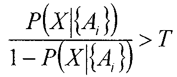
일반 연판정
*특정 실시양태에서, 각각의 이상상태의 특정 특성에 맞춤 구성된 방법을 이용하여 비콘이 특정 이상상태를 나타내는 확률이 할당된다. 이하의 방법에서, 개별 이상상태 확률이 공지된 베이지안 규칙(Bayes' Rule)을 근거로 하는 다음의 형태를 가진다. General soft decision
In certain embodiments, the probability that a beacon represents a particular abnormal state is assigned using a method tailored to the particular characteristic of each abnormal state. In the following method, the individual anomaly probability has the following form based on known Bayes' rule.
삭제delete
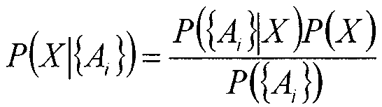
다시 한번 상기시키자면, 개별 확률 함수는 당해 기술분야에서 통상의 지식을 가진 자가 이론적 결과 또는 경험적 데이터로부터 얻을 수 있다. 예를 들어, 특정 구현예에서, 비콘들의 특정 집합이 알려진 이상상태를 보인다고 알려져 있거나 강력하게 의심될 수 있고, 그 후, 이들 비콘의 속성 및/또는 타 비콘과의 관계의 속성이 알려진, 또는 의심되는 이상상태와 상관처리될 수 있다. Once again, the individual probability function can be obtained from the theoretical results or empirical data by those of ordinary skill in the art. For example, in certain implementations, a particular set of beacons may be known or strongly suspected to exhibit known anomalies, and thereafter the attributes of those beacons and / Lt; / RTI >
실시예Example
다음의 설명적 실시예들은 본 발명의 예시적 구현예에 의해 정의되는 이상상태가 비콘, 관계, 스캔, 및 제출의 속성을 이용하여 검출될 수 있는 방법을 보여준다. 일반적으로, 본 발명의 범위는 본원 명세서에서 정의되는 바와 같은 속성들의 집합을 근거로 하여 이상상태의 존재 여부에 대한 연판정 또는 경판정을 하기 위해 사용되는 모든 가능한 방법을 포함한다. 이들 예시는 이러한 방법이 운용될 수 있는 방법을 더 잘 설명하기 위해 제공된다. 예시들은 본 발명에 의해 커버되는 모든 방법을 총망라한 집합으로 해석되지 않아야 하며, 복합적인 이상상태 검출 방법을 구축하기 위해 제한 없이 조합되거나 확장될 수 있다. The following illustrative embodiments show how anomalies defined by an exemplary implementation of the present invention can be detected using attributes of beacons, relationships, scans, and submissions. In general, the scope of the present invention encompasses all possible methods used to make a soft or hard decision on the existence of an abnormal state based on a set of attributes as defined herein. These examples are provided to better illustrate how these methods can be operated. The examples should not be construed as an exhaustive set of all methods covered by the present invention, and may be combined or extended without limitation to form a composite abnormal state detection method.
이하의 예시는 다양한 임계치 값을 언급한다. 통상적으로 임계치는 종래 기술에 잘 알려진 2개의 메트릭에 의해 정량화되는 것과 같은 검출 시스템의 성능 목표를 충족하도록 선택된다: 오경보 확률(false alarm probability)과 미탐지 확률(miss probability). 이러한 경우, 오경보 확률은, 검출기가 비콘이 실제로는 이상상태가 아닐 때, 이를 이상상태라고 잘못 식별할 우도이다. 미탐지 확률은 이상 비콘이 이상상태라고 식별되지 않을 우도이다. 직감적으로, 효과적인 이상상태 검출기는 오경보 확률과 미탐지 확률을 모두 최소화해야 한다. 그러나 임의의 중요한 적용예에서, 0인 오경보와 미탐지 확률을 모두 얻는 것은 불가능할 것이며, 한 확률을 감소시키기 위해 임계치를 조절하는 것이 나머지 다른 확률을 종종 증가시킬 것이다. 표준적인 실시는 최대 허용 가능한 오경보 확률을 선택하고, 그 후, 최대 오경보 확률 이하로 유지하면서 미탐지 확률을 최소화하도록 임계치를 조절하는 것이다. The following examples refer to various threshold values. Typically, the threshold is selected to meet the performance objectives of the detection system, such as quantified by two metrics well known in the art: false alarm probability and miss probability. In this case, the false alarm probability is a possibility that the detector erroneously identifies the beacon as an abnormal state when the beacon is not actually abnormal. The non-detection probability is also such that the abnormal beacon is not identified as abnormal. Intuitively, an effective anomaly detector should minimize both false alarm probabilities and undetected probabilities. In any important application, however, it may not be possible to obtain both zero false alarms and undetected probabilities, and adjusting the threshold to reduce one probability will often increase the other probability. The standard practice is to select a maximum allowable false alarm probability and then adjust the threshold to minimize the probability of undetecting while keeping it below the maximum false alarm probability.
결국, 임계치 값의 선택은 경우에 따라 달라지는 설계 결정일 것이며, 이론적 분석 또는 경험적 테스트를 통해 수행될 수 있다. Finally, the choice of the threshold value will be a design decision that may vary from case to case and can be done through theoretical analysis or empirical testing.
재배치Relocation
예시 1:Example 1:
도 5는 비콘 재배치(beacon relocation)를 검출하기 위한 방법을 도시한다. 하나의 실시양태에서, 비콘(B0)의 재배치가 방법(500)에 의해 검출된다. 상기 방법(500)은 비콘(B0)과 관계를 갖는 비콘들(이웃 비콘)의 속성과 상기 관계의 속성을 검색하는 단계(단계(501))를 포함한다. 그 후, 임의의 임계치(Ts)(예를 들어, 0.99)를 초과하는 안정도 값을 갖는 이웃 비콘들의 부분 집합을 모으는 단계(단계(502))와 비콘(B0)과의 관계가 임의의 임계치(Tr)를 초과하는 품질(예를 들어, 침묵 시간, 추정된 거리, 및 상기 관계의 관측 횟수를 근거로 할 수 있음)을 갖는 이웃 비콘들의 부분 집합을 모으는 단계(단계(503)). Figure 5 illustrates a method for detecting beacon relocation. In one embodiment, relocation of the beacon B0 is detected by the
안정한 이웃(stable neighbor)이 상이한 프로토콜로부터 올 수 있다. 즉, 802.11 비콘의 안정한 이웃의 일부 또는 전부가 UMTS 셀룰러 비콘일 수 있다. 이웃 비콘의 안정도가 본원 명세서에 제공되는 방법들의 임의의 조합 또는 본원 명세서에 제공되는 방법과 외부 소스로부터의 보조 정보(예를 들어, 도시의 공공 사업 부서의 시립 비콘(municipal beacon) 위치의 확인)의 조합을 이용하여 결정될 수 있다. 예시적 안정도 함수는 본원 명세서의 다음 섹션에서 제공된다. Stable neighbors can come from different protocols. That is, some or all of the stable neighbors of the 802.11 beacons may be UMTS cellular beacons. The stability of the neighbor beacons may be determined by any combination of the methods provided herein or by the methods provided herein and from the external sources (e.g., identification of the municipal beacon location of the city's public utility) As shown in FIG. An exemplary stability function is provided in the next section of the specification.
그 후, 상기 방법은 비콘(B0)의 추정 위치로부터 자신의 안정한 이웃 각각의 추정 위치까지의 거리들의 집합 {D}를 결정한다(여기서, 추정 위치는 각각의 비콘의 속성에 저장된다)(단계(504)). 그 후, 상기 방법은 집합 {D} 내 각각의 거리를 임계치 Td에 비교하고, Td를 초과하는 거리를 갖는 비콘을 선택한다(단계(505)). Td의 값은 비콘의 통상의 송신 범위를 기초로 결정된다. 다시 말하면, Td는 거리를 포착하는데, 이 거리 이상에서, 2개의 올바르게 위치된(즉, 올바르게 알려진 비콘 위치를 갖는) 비콘들이 동시에 관측되지 않아야 한다. 그 후, 비콘(B0)과의 관계가 임의의 임계치 Tq(예를 들어, 7일) 미만의 침묵 시간을 갖는 비콘들이 선택된다(단계(506)). 마지막으로, 상기 방법은 동일한 비콘 중 하나 이상이 단계(505 및 506)에서 선택된 경우 비콘(B0)이 재배치된 것이라고 선언한다.The method then determines a set of distances {D} from the estimated location of the beacon B0 to the estimated location of each of its stable neighbors, where the estimated location is stored in an attribute of each beacon (Step 504). The method then compares each distance in set {D} to a threshold Td and selects a beacon with a distance exceeding Td (step 505). The value of Td is determined based on the normal transmission range of the beacon. In other words, Td captures the distance, and beyond this distance, two correctly positioned (i.e., beacons with the right known beacon position) must not be observed simultaneously. Thereafter, beacons with a silence time in which the relationship with beacon B0 is less than a certain threshold Tq (e.g., 7 days) are selected (step 506). Finally, the method declares that if one or more of the same beacons are selected in
예시 2:Example 2:
여기서 비콘 재배치를 검출하기 위한 또 다른 구현예가 제공된다. 당해 구현예에 있어서, 이웃 비콘들은 도 6에 도시된 방법(600)에 따라 공간적으로 클러스터링되며, 도 7은 비콘(B0)의 비콘 재배치를 검출하는 또 다른 방법(700)을 도시한다. 우선, 비콘(B0)과의 관계를 갖는 비콘의 속성이 검색된다(단계(501)). 그 후, 이웃 비콘들(이 예시에서 기준 지점으로서 기능함)이 도 6의 방법(600)에 따라 공간적으로 클러스터링된다. Here, another embodiment for detecting beacon relocation is provided. In this embodiment, neighboring beacons are spatially clustered according to the
상기 방법(600)에 따라, B0와 관련된 각각의 비콘에 대한 추정 위치가 검색되고(단계(601)), 비콘(B0)의 추정 위치에서 초기 클러스터 중심(initial Cluster Center)이 지정된다(단계(602)). 그 후, 각각의 이웃 비콘(Bi)에 대해, 클러스터링 방법(600)은 기존 클러스터 중심까지의 거리를 결정한다(단계(603)). 비콘(Bi)의 거리(D1)(예를 들어, 1km) 내에 클러스터 중심이 존재하는 경우, 비콘(Bi)이 상기 클러스터에 추가된다(단계(604)). 특정 구현예에서, 거리(D1)의 값은 비콘(Bi)과 동일 유형의 비콘의 통상의 커버리지 영역과 관련되고/되거나 커버리지 영역에 의해 부분적으로 결정된다. 비콘(Bi)의 거리(D2)(예를 들어, 2km) 내에 어떠한 클러스터 중심도 없는 경우, 새로운 클러스터 중심이 비콘(Bi)의 위치에서 생성된다(단계(605)). 특정 구현예에서, 거리(D2)의 값은 특정 임계치 이상에서 비콘(B0)이 재배치됐을 우도가 있게 하는 거리의 크기에 의해 부분적으로 결정된다. According to the
클러스터 중심을 생성한 후, 서로의 거리(D2) 내에 어떠한 2개의 클러스터 중심도 없어야 하고, 어떠한 클러스터도 클러스터 중심으로부터의 거리(D1)보다 큰 거리를 갖는 비콘을 갖지 않아야 한다. 그 후, 클러스터링 방법이 클러스터에 아직 추가되지 않은 임의의 비콘을 해결하며, 이를 가장 가까운 클러스터로 추가한다(단계(606)).After generating the cluster centers, there should be no two cluster centers within the distance D2 to each other, and no cluster should have a beacon with a distance greater than the distance D1 from the cluster center. The clustering method then resolves any beacons that have not yet been added to the cluster and adds it to the closest cluster (step 606).
공간 클러스터링 방법(600)을 완료한 후, 클러스터의 각각의 구성원의 안정도 및/또는 클러스터 내 비콘의 개수를 근거로 하여 각각의 클러스터에 안정도 값이 할당된다(단계(701)). 예를 들어, 클러스터 내 최대 비콘 안정도와 동일한 안정도를 갖도록 클러스터가 할당받는다. 그 후, 상기 방법은 각각의 클러스터 중심에서부터 비콘(B0)까지의 거리를 결정한다(단계(702)). 비콘(B0)으로부터의 거리(D3)(예를 들어, 2km)보다 큰 거리를 갖고, 안정도(S1)보다 큰 안정도를 갖는 클러스터가 선택된다(단계(703)). 특정 구현예에서, 거리(D3)의 값은, 부분적으로, 특정 임계치 이상에서 비콘(B0)이 재배치됐을 우도가 있게 하는 거리의 크기에 의해 결정된다. 선택된 클러스터들의 집합 중에서, 상기 방법은 시간(Tq)(예를 들어, 30일)보다 짧은 최소 침묵 시간을 갖는 클러스터를 선택한다(단계(704)). 임의의 클러스터가, 거리가 거리(D3)보다 큼, 안정도가 안정도(S1)보다 큼, 및 침묵 시간이 시간(Tq)보다 짧음의 세 가지 기준을 모두 만족하는 경우, 방법은 비콘(B0)은 재배치됐다고 선언한다(단계(705)).After completing the
예시 3:Example 3:
도 8은 비콘 재배치를 검출하는 또 다른 방법(800)을 도시한다. 먼저, 비콘(B0)과의 관계를 갖는 비콘들의 속성이 검색된다(단계(501)). 그 후, 상기 방법은, 앞서 기재된 방법(600)을 이용하여 이웃 비콘들을 공간적으로 클러스터링한다. 공간 클러스터링(600)을 완료한 후, 클러스터 내 이웃들의 개수와 클러스터의 침묵 시간을 근거로 하여 초기 안정도 값(Si)이 각각의 클러스터(Ci)에게 할당된다(단계(701)). 클러스터 내 이웃들의 개수는 클러스터가 한 단위로 재배치되었을 확률과 관련되고, 클러스터의 침묵 시간은 B0가 클러스터로부터 멀리 재배치되었을 확률과 관련된다. 초기 안정도 값은, 경험적 관측치, 또는 클러스터가 클러스터 크기 및 침묵 시간의 함수로서 관련 노드에 대한 유효한 정보를 제공할 확률을 나타내는 분석적 수식을 기초로 생성될 수 있다. FIG. 8 shows another
그 후, 초기 안정도 값(Si)은 각각의 클러스터에 대한 공동 안정도 값(joint stability value)(Ji)을 생성하도록 사용된다(단계(801)). 공동 안정도 값은 단 하나의 클러스터만 B0의 현재 위치를 올바르게 반영할 수 있다는 사실을 정량화하며, 따라서 복수의 클러스터의 존재는 B0의 진실한 위치에 대한 상충하는 정보를 생성한다. 예를 들어, 하나의 구현예에서, 공동 안정도 값이 1로 합산되도록 초기 안정도 값을 정규화함으로써, 공동 안정도 값이 생성된다. 다음의 수학식을 참조할 수 있다. The initial stability value Si is then used to generate a joint stability value Ji for each cluster (step 801). The joint stability value quantifies the fact that only one cluster can correctly reflect the current position of B0, and thus the presence of a plurality of clusters produces conflicting information about the true position of B0. For example, in one implementation, a joint stability value is generated by normalizing the initial stability value such that the joint stability value is summed to one. The following equation can be referred to.
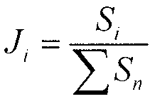
또 다른 구현예에서, 공동 안정도 값은 다음의 수식에 따라 생성되며, 공동 안정도(Ji)가 결코 초기 안정도(Si)를 초과하지 않도록 상한을 유지하면서 클러스터들의 상호 배타성을 강제한다. In another embodiment, the co-stability value is generated according to the following equation and forces mutual exclusivity of the clusters while maintaining the upper limit such that the co-stability (Ji) never exceeds the initial stability (Si).
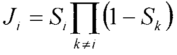
클러스터들에 대해 공동 안정도 값(Ji)을 생성한 후, 상기 방법은 B0의 추정 위치에 대응하는 클러스터(C0)를 결정하고(단계(802)), C0의 공동 안정도 값(J0)을 이용하여 재배치에 대한 B0의 확률을 할당한다(단계(803)). 다시 말하면, J0는 비콘(B0)이 재배치되었을 확률과 밀접하게 관련된다. 따라서, 일부 구현예에서, 위치의 확률을 J0와 동일하도록 직접 설정하는 것이 충분할 수 있지만, 다른 적용예는 재배치의 만족스러운 확률을 반환하기 위해 추가 스케일링(scaling) 또는 오프셋(offset)을 필요로 할 수 있다. 또한 B0의 위치가 추정되는 동안 재배치의 확률이 결정될 수 있고, 재배치의 확률이 최소화되도록 위치 추정치가 선택될 수 있다. 다시 말하면, 시스템은 복수의 후보 위치(candidate position)를 결정하고, 그 후 그들 각자의 재배치 확률을 비교하여, 어느 위치가 가장 올바를 확률이 높은지를 결정할 수 있다. After generating the joint stability value Ji for the clusters, the method determines a cluster C0 corresponding to the estimated position of B0 (step 802) and uses the joint stability value J0 of C0 A probability of B0 for relocation is allocated (step 803). In other words, J0 is closely related to the probability that the beacon B0 has been relocated. Thus, in some implementations, it may be sufficient to set the probability of location to be equal to J0 directly, but other applications may require additional scaling or offset to return a satisfactory probability of relocation . Also, the probability of relocation can be determined while the position of B0 is estimated, and the position estimate can be selected such that the probability of relocation is minimized. In other words, the system can determine a plurality of candidate positions, and then compare their respective relocation probabilities to determine which location is most likely to be right.
예시 4:Example 4:
도 9는 비콘 재배치를 검출하기 위한 또 다른 방법(900)을 도시한다. 이 구현예에서, 포지셔닝된 스캔이 방법(800)에서 기준 지점으로서 사용됐던 이웃 비콘들을 대신한다. 이웃 비콘을 대신하여 스캔을 이용할 때, 구체적 안정도 함수는 상이한 형태를 가질 수 있지만, 기능 블록은 거의 유사하고, 따라서 동일한 참조번호가 사용된다. 우선, 비콘(B0)이 관측된 포지셔닝된 스캔의 속성이 수신된다(단계(901)). 그 후, 상기 방법이 앞서 기재된 방법(600)에 따라 포지셔닝된 스캔을 공간적으로 클러스터링하고, 단계(701)와 관련하여 앞서 기재된 것처럼, 초기 안정도 값을 각각의 클러스터에게 할당한다. Figure 9 illustrates another
그 후, 상기 방법(900)은 초기 안정도 값들의 집합을 사용하여, 스캔의 각각의 클러스터에 대해 공동 안정도 값을 생성한다(801). 클러스터에 대한 공동 안정도 값을 생성한 후, B0의 추정 위치에 대응하는 클러스터가 결정된다(단계(802)). 마지막으로, 비콘(B0)의 추정 위치에 가장 가까운 스캔의 클러스터의 공동 안정도 값이 사용되어, B0가 재배치됐을 확률을 결정한다(단계(803)). The
예시 5:Example 5:
도 10은 비콘 재배치를 검출하는 또 다른 방법(1000)을 도시한다. 상기 방법은 비콘(B0)과의 관계를 갖는 비콘들의 속성을 검색하는 것으로(단계(501)) 시작한다. 그 후, 상기 방법은 이웃 비콘들 중, 비콘(B0)과 동일한 패밀리에 속하는 임의의 비콘(동일한 하드웨어에 위치하거나 동일한 개인이나 기업에 의해 소유되고 다함께 재배치될 것으로 예상되는 비콘)을 선택한다(단계(1001)). 비콘(B0)의 패밀리의 임의의 구성원이 확률(P1)보다 높은 재배치 확률을 가지는 경우, 비콘(B0)은 재배치된 것으로 선언된다(1002).Figure 10 shows another
예시 6:Example 6:
도 11은 비콘 재배치를 검출하는 또 다른 방법(1100)을 도시한다. 상기 방법은 비콘(B0)과의 관계를 갖는 비콘들의 속성 및 이들 관계의 속성을 검색하는 것으로(단계(501)) 시작한다. 각각의 관계의 침묵 시간의 함수를 이용하여 긴 침묵 시간을 갖는 관계보다 짧은 침묵 시간을 갖는 관계가 더 큰 가중치를 수신하도록 가중치가 적용된다(단계(1101)). 그 후, 상기 방법은 비콘(B0)의 추정된 위치에서부터 비콘(B0)의 이웃의 추정된 위치까지의 거리를 결정한다(단계(1102)). 그 후, 각각의 거리는 자신의 대응하는 가중치와 조합되어, 각각의 관계에 대한 가중된 거리 값을 생성한다(단계(1103)). 가중된 거리 값들의 집합 중에서, K번째 백분위수(예를 들어, K=90)의 가중된 거리가 찾아진다(예를 들어, 단계(1104)). 당해 기술분야에서 통상의 지식을 가진 자에게 익숙한 방법을 이용하여, 가중된 거리 값들을 오름 차순으로 정렬하고, 천장(0.9 * L)과 동일한 인덱스를 갖는 값을 선택함으로써, K번째 백분위수가 찾아질 수 있으며, 여기서 "천장(ceil)"은 천장 함수-다음 정수로 올림-를 나타내고, L은 리스트의 값들의 개수이다.FIG. 11 shows another
마지막으로, K번째 백분위수의 가중된 거리가 임의의 임계치(Td)를 초과하는 경우, 상기 방법은 비콘(B0)이 재배치됐다고 선언한다(단계(1105)). 큰 K번째 백분위수의 가중된 거리는 비콘(B0)이 비콘(B0)을 비콘(B0)의 현재 추정 위치로부터 멀리 위치하는 비콘으로 연결하는 관계의 큰 비율을 가짐을 나타낸다. 차례로, 많은 수의 명백히 멀리 위치하는 비콘들과의 관계가 비콘(B0)은 더 이상 자신의 추정 위치에 있지 않음을 암시한다. 더 짧은 침묵 시간을 갖는(더 최근에 관측된) 관계가 더 높은 가중치를 수신한다는 사실과 조합할 때, 큰 K번째 백분위수의 가중된 거리는 비콘(B0)이 비콘(B0)의 현재 추정 위치로부터 멀리 떨어진 충분한 개수의 이웃을 갖는다고 관측되었을 뿐만 아니라, 관측은 비교적 최근의 것이며, 비콘(B0)은 재배치됐을 우도가 높음을 의미한다. Finally, if the weighted distance of the Kth percentile exceeds a certain threshold Td, the method declares that the beacon B0 has been relocated (step 1105). The weighted distance of the large Kth percentile indicates that the beacon B0 has a large proportion of the relationship linking the beacon B0 to the beacon located farther away from the current estimated location of the beacon B0. In turn, the relationship with a large number of apparently far-away beacons implies that the beacon B0 is no longer in its estimated location. When combined with the fact that a (more recently observed) relationship with a shorter silence time receives a higher weight, the weighted distance of the larger Kth percentile is such that the beacon B0 is shifted from the current estimated position of the beacon B0 Not only has it been observed to have a sufficient number of neighbors farther away, but observations are relatively recent, meaning that beacons (B0) are more likely to be relocated.
예시 7:Example 7:
도 12는 비콘 재배치를 검출하는 또 다른 방법(1200)을 도시한다. 도 13은 비콘 재배치를 검출하기 위해 방법(1200)에 의해 사용되는 클러스터링 방법을 도시한다. 상기 방법은 비콘(B0)의 관계 및 비콘(B0)이 관련된 노드의 속성을 검색함으로써(단계(501)) 시작된다. 그 후, 비콘(B0) 및 그 이웃 각각의 추정 위치를 이용하여, 상기 방법은 비콘(B0)과 각각의 이웃 간의 거리를 찾을 것을 요구한다(단계(1201)). 거리들의 집합을 이용하여, 거리(D)(예를 들어, 2km)보다 작은 비콘(B0)(도 13의 (1301))으로부터 거리를 갖는 이웃 비콘들의 집합을 선택하고, 선택된 집합을 홈 클러스터(Home Cluster)라고 지정한다(단계(1202) 및 도 13에서 (1302)로 나타남).12 shows another
홈 클러스터(1302) 내 비콘의 속성을 이용하여, 상기 방법은 상기 홈 클러스터 내 비콘의 총 개수(H)를 찾고(단계(1203), 홈 클러스터 구성원 중에서 최소 침묵 시간(Q)을 찾는다(단계(1204)). 마지막으로, 상기 방법은 비콘(B0)이 재배치되었을 확률, ![]()
![]()
명확함을 위해, 다른 클러스터(1303 및 1304)가 도 13에 도시된다. 또한, 클러스터(1305, 1306 및 1307) 사이의 거리가 도시된다. 도 13이 클러스터 거리를 클러스터(1302, 1303, 및 1304)의 외곽 도달거리(outer reaches)로서 도시하지만, 클러스터 중심들 간 거리와 같은 그 밖의 다른 거리 측정치가 사용될 수 있다. For clarity,
예시 8:Example 8:
도 14는 도 15에 도시된 바와 같은 비콘 그래프를 구축하는 방법(1500)을 이용하여 비콘 재배치를 검출하는 또 다른 방법(1400)을 도시한다. 상기 방법(1400 및 1500)을 설명하기 위해 도 2도 참조한다. 우선, 상기 방법은 비콘(B0)과 관련된 비콘의 속성 및 이러한 관계의 속성을 수신한다(단계(501)). 그 후, 이웃 비콘들 간의 관계를 검색함으로써(단계(1501)), 비콘(B0)(도 2의 (201)) 및 그 이웃(예를 들어, 207)의 비콘 그래프가 구성된다(도 15의 방법(1500)인 도 14의 단계(1500)). 비콘(B0) 및 각각의 이웃에 대하여, 상기 방법은 비콘 그래프에서 노드를 생성하고(단계(1502)), 한 쌍의 비콘을 연결하는 각각의 관계에 대해 에지를 생성한다(단계(1503)). FIG. 14 shows another
그 후, 각각의 쌍의 연결된 노드(Ni 및 Nj) 사이의 공간적 거리들의 집합 {Dij}이, 이들 노드에 대응하는 비콘(Bi 및 Bj)의 추정 위치를 이용하여 찾아진다(단계(1401)). 그 후, 상기 방법은, 구획선(205)이 노드가 적어도 거리(D1)(예를 들어, 2km)만큼 이격된 추정 위치를 갖는 에지(206)만 가로지르도록 비콘 그래프(200)를 2개의 서브 그래프(203, 204)로 구획한다(단계(1402)). 특정 구현예에서, 거리(D1)의 값은 부분적으로 특정 임계치 이상에서 비콘(B0)이 재배치되었을 우도가 있도록 하는 거리의 크기에 의해 결정된다. 완전 탐색(exhaustive search)에 의해, 또는 그래프 이론의 문헌에서 발견되는 그래프 구획 알고리즘에 의해 최소 가중치 구획선이 찾아질 수 있다. A set of spatial distances {Dij} between each pair of connected nodes Ni and Nj is then sought using the estimated location of the beacons Bi and Bj corresponding to these nodes (step 1401) . Thereafter, the method is repeated until the
이러한 구획선이 존재한다면, 상기 방법은 상구획선(205)을 가로지르는 에지(206)로 연결된 노드(들)(201)를 찾고(단계(1403)), 그들이 속하는 서브 그래프(203, 204)를 근거로 하여 이들을 2개의 부분 집합으로 분할한다(단계(1404)). 구획선을 가로지르는 에지가 차지하는 거리는 비콘의 송신 범위보다 훨씬 길며, 따라서 구획선은 부분 집합들 중 하나 내 노드가 재배치되었음을 나타낸다. If such a section line is present, the method finds (step 1403) node (s) 201 connected to edge 206 crossing
마지막으로, 비콘(B0)이 2개의 부분 집합 중 더 작은 것에 속하는 경우, 상기 방법은 비콘(B0)과 상기 부분 집합에 있는 노드를 갖는 그 밖의 다른 비콘이 재배치되었다고 선언하며, (더 작은 부분 집합의 둘 이상의 구성원이 존재하는 경우) 비콘들은 하나의 그룹을 이룬다(단계(1405)). 따라서 비콘(B0) 및 이의 그룹 구성원은 미래의 재배치 이벤트에서 다 같이 이동할 것으로 예상될 수 있다. Finally, if the beacon B0 belongs to the smaller of the two subsets, the method declares that the beacon B0 and any other beacon with the node in the subset have been relocated, The beacons form a group (step 1405). Thus, beacon B0 and its group members may be expected to move together in future relocation events.
이동성Mobility
앞서 기재한 바와 같이, 특정 실시양태에서 비콘이 사용자에 의해 운반되거나 비히클로 수송되는 동안, 비콘이 송신하는 경우, 비콘은 이동형이라고 선언된다. As noted above, in certain embodiments, when a beacon is transmitted while being transported by a user or transported by a vehicle, the beacon is declared mobile.
예시 1:Example 1:
도 16은 비콘 이동성(beacon Mobility)을 검출하는 방법(1600)을 도시한다. 먼저, 상기 방법은 비콘(B0)의 속성을 검색한다(단계(1601)). 그 후, 비콘(B0)의 식별자 및 제조업체 정보가, 이동형 장치를 비교하기 위해 알려진 제조업체 및 식별자의 "블랙 리스트"와 비교된다(단계(1602)). 비콘(B0)의 식별자 및/또는 제조업체 정보가 블랙 리스트에서 나타나는 경우, 상기 방법은 비콘(B0)이 이동형이라고 선언한다(단계(1603)). Figure 16 shows a
제조업체들 간에, 이동형 및 휴대용 장치에 대해 고유 식별자의 특정 패턴(예를 들어, 802.11 장치의 MAC 주소 범위)을 지정하는 것은 일반적이다. 또한, 이동형 및 휴대용 장치를 배타적으로 생산하는 일부 제조업체가 존재하며, 따라서 제조업체 정보만으로 특정 비콘이 이동형이라고 나타내기에 충분할 수 있다. It is common among manufacturers to specify specific patterns of unique identifiers (e.g., MAC address ranges for 802.11 devices) for mobile and portable devices. In addition, there are some manufacturers that exclusively produce mobile and portable devices, and thus the manufacturer information alone may be sufficient to indicate that a particular beacon is mobile.
예시 2:Example 2:
도 17은 비콘 이동성을 검출하는 또 다른 방법(1700)을 도시한다. 우선, 상기 방법은 비콘(B0)을 포함하는 관계의 개수를 찾는다(단계(1701). 그 후, 비콘(B0)의 이웃 각각에 대하여, 관계의 개수를 찾는다(단계(1702)). 그 후, 당해 기술분야에서 통상의 지식을 가진 자에게 익숙한 방법을 이용하여, 비콘(B0)의 이웃들의 집합에 걸쳐 K번째 백분위수(예를 들어, K=99)의 관계의 개수가 찾아진다(단계(1703)). 특정 실시양태에서, K의 값은 전체 비콘 모집단의 부분(fraction)으로서의 이동형 비콘의 예상되는 개수와, 이동형 비콘과 비-이동형 비콘에 대한 예상되는 관계의 개수의 차에 의해 부분적으로 결정된다. 마지막으로, 비콘(B0)의 관계의 개수가 비콘(B0)의 이웃들 간의 K번째 백분위수의 관계의 계수를 초과하는 경우, 상기 방법은 비콘(B0)이 이동형이라고 선언한다(단계(1704)).Figure 17 shows another
일반적으로, 이동형 비콘은, 통상의 비콘 송신 범위보다 상당히 더 큰 반경을 갖는 공간적 영역으로부터의 이웃으로 관측될 기회를 가진다. 따라서 이동형 비콘은 종종 비-이동형 이웃들에 의해 누적되는 관계의 개수를 훨씬 초과하는 극도로 많은 개수의 관계를 형성한다. In general, a mobile beacon has an opportunity to be observed neighbors from a spatial region having a radius much larger than the normal beacon transmission range. Thus, mobile beacons often form an extremely large number of relationships well beyond the number of relationships accumulated by non-mobile neighbors.
예시 3:Example 3:
도 18은 비콘 이동성을 검출하는 또 다른 방법을 도시한다. 먼저, 상기 방법은 비콘(B0)이 재배치되었고 재포지셔닝되었다고 선언된 적이 있는 모든 인스턴스의 레코드를 데이터베이스에 유지한다(단계(1801)). 그 후, 재배치 및 재포지셔닝의 이러한 인스턴스 중에서, 지난 T1 시간 간격(예를 들어, 365일) 내에 발생한 재배치의 개수가 결정된다(단계(1802)). 마지막으로 재배치 및 재포지셔닝 이벤트의 개수가 임계치(R)(예를 들어, 5)를 초과하는 경우, 상기 방법은 비콘(B0)이 이동형이라고 선언한다(단계(1803)).Figure 18 shows another method of detecting beacon mobility. First, the method maintains a record of all instances where the beacon B0 has been relocated and declared to be repositioned in the database (step 1801). Then, among these instances of relocation and repositioning, the number of relocations occurring within the last T1 time interval (e.g., 365 days) is determined (step 1802). Finally, if the number of relocation and repositioning events exceeds a threshold R (e.g., 5), the method declares beacon B0 as mobile (step 1803).
특정 구현예에서, 숫자(T1) 및 임계치(R)의 값은 부분적으로 비콘 속성이 시스템에서 업데이트되는 빈도와, 빈번하게 재배치되는 비콘과 진정한 이동형 비콘 사이의 구별에 의해, 공동으로 결정된다. 빈번하게 재배치되는 비콘은, 시스템이 재배치를 검출하고 비콘을 재포지셔닝하며 이를 신뢰할 만한 사용자 포지셔닝을 위해 이용할 수 있을 만큼 충분히 길게 고정 위치에 있을 것이다. 그러나 이동형 비콘은 자신의 위치를 시스템이 반응할 수 있는 것보다 더 빨리 계속 바꿀 것이며, 결코 신뢰할 만한 사용자 포지셔닝을 제공하지 않을 것이다. In certain implementations, the values of the numbers T1 and R are jointly determined by the distinction between the frequency at which the beacon attribute is updated in the system, and the beacon that is frequently relocated and the true mobile beacon. Frequently relocated beacons will be in a fixed position long enough for the system to detect relocation and reposition the beacon and use it for reliable user positioning. However, a mobile beacon will change its position more quickly than the system can respond to, and will never provide reliable user positioning.
예시 4:Example 4:
도 19는 비콘 이동성을 검출하는 또 다른 방법(1900)을 도시한다. 먼저, 상기 방법은 비콘(B0)을 포함하는 관계의 총 개수 N을 찾는다(단계(1901)). 그 후, 상기 방법은 얼마나 많은 비콘(B0)의 관계가 시간(T)(예를 들어, 1일)보다 짧은 지속 시간(각각의 관계의 속성으로 저장되거나, 관계의 최초 관측과 마지막 관측 사이의 시간차를 기초로 결정됨)을 가지는지를 결정한다(단계(1902)). 특정 구현예에서, 시간(T)의 값은 부분적으로 이동형 비콘과 비-이동형 비콘의 통상적인 관계 지속 시간의 분포에 의해 결정된다. 마지막으로, 다음의 형태의 함수를 이용함으로써, 비콘(B0)이 이동형인 확률이 결정된다(단계(1903)). FIG. 19 shows another

종종, 이동형 비콘은 많은 개수의 총 관계와, 짧은 지속 시간 관계의 큰 부분(fraction) 모두를 가질 것이다. 특히, (반복되는 루트와 반대인) 명백하게 랜덤 방식으로 이동하는 이동형 비콘은 이들은 비콘 수명 동안 단 한 번 그들의 이웃의 큰 부분 집합에 물리적으로 근접할 수 있다는 사실 때문에, 주로 짧은 지속 시간 관계를 누적할 것이다. Often, mobile beacons will have both a large number of total relationships and a large fraction of short duration relationships. In particular, mobile beacons moving in an apparently random manner (as opposed to repeated roots) accumulate primarily short duration relationships because of the fact that they can physically be close to a large subset of their neighbors once during beacon life will be.
편재성Ubiquity
앞서 기재된 바와 같이, 특정 실시양태에서, 비콘은 타 비콘과 중복되는 식별자를 가지고/갖거나 서로 구별하기 어렵거나 불가능하게 하는 그 밖의 다른 속성을 가질 경우 편재형이라고 선언된다. 즉, 비콘은 편재성의 이상상태를 보이는 것으로 결정된다. As noted above, in certain embodiments, a beacon is declared obsolete when it has / has other attributes that have / have identifiers that overlap with the tavicons or make it difficult or impossible to distinguish one from the other. That is, the beacon is determined to exhibit an abnormal state of ubiquity.
예시 1:Example 1:
도 20은 편재성을 보이는 비콘을 검출하는 방법(2000)을 도시한다. 우선, 상기 방법은 비콘(B0)의 관계 및 이웃 비콘의 속성을 검색한다(단계(501)). 그 후, 임의의 임계치(S1)보다 높은 (비콘 속성의 데이터베이스에 저장되는) 안정도 값을 갖고, 비콘(B0)과의 관계가 임의의 임계치(Q1)보다 높은 품질 값을 갖는 이웃 비콘들이 선택된다(단계(2001)). 특정 구현예에서, 임계치(S1)의 값 및 임계치(Q1)의 값은 부분적으로 시스템의 안정도 및 품질의 통상의 값과 다양한 성능 고려사항에 의해 결정될 것이다. 20 shows a
그 후, 상기 방법은 앞서 기재된 방법(600)을 이용하여 선택된 이웃들의 세트를 공간적으로 클러스터링하고, 각각의 클러스터에 대해 관측 간격을 정의한다(단계(2002)). 관측 간격을 정의하기 위해, 방법(2000)의 한 가지 구현예는 간격의 시작부분을 비콘(B0)과 클러스터의 구성원 간의 임의의 관계의 제1 관측의 시점으로 설정하고, 동일한 클러스터에 대하여 간격의 종료 부분을 비콘(B0)과 클러스터의 구성원 간의 임의의 관계의 마지막 관측의 시점으로 설정한다. 결국, 클러스터의 임의의 구성원과 함께 비콘(B0)의 모든 관측의 시점은 클러스터의 관측 간격 내에 속해야 한다. The method then spatially clusters the set of selected neighbors using the
마지막으로, 임의의 2개의 클러스터의 간격이 겹치는 경우(간격들의 교차영역이 0이 아닌 지속 시간의 간격을 형성하는 경우), 방법은 비콘(B)이 편재형이라고 선언한다(단계(2003)). 공간 클러스터가 비콘(B0)의 커버리지 반경보다 큰 거리만큼 이격되어 있다는 사실을 고려하면, 겹치는 관측 간격들은 단일 간격 동안 비콘(B0)이 복수의 개별 위치에서 관측되었으며, 따라서 편재형임을 나타낸다. Finally, if the intervals of any two clusters overlap (if the intersection region of intervals forms an interval of non-zero duration), then the method declares beacon B as a pivoted (step 2003) . Given the fact that the spatial clusters are spaced a greater distance than the coverage radius of the beacon B0, the overlapping observation intervals indicate that the beacon B0 has been observed at a plurality of discrete locations during a single interval and is therefore ubiquitous.
예시 2:Example 2:
도 21은 편재성을 보이는 비콘을 검출하는 또 다른 방법(2100)을 도시한다. 우선, 상기 방법은, 비콘(B0)이 관측된 스캔을 검색하는 것으로 시작하며, 스캔 속성은 신뢰할 만한 스캔 위치를 포함한다(단계(901)). 스캔 위치의 신뢰도는 스캔과 관련된 위치의 소스와 관련된다. 예를 들어, 하늘의 비교적 선명한 뷰의 경우, GPS-생성 위치는 Wi-Fi 기반 포지셔닝 시스템으로부터의 위치 추정치보다 더 신뢰할 만할 우도가 높을 것이며, 따라서 셀 타워(cell tower) 기반 위치 추정치보다 더 신뢰할 만할 우도가 높다. 일반적으로 각각의 포지셔닝 방법은, 신뢰도를 기준으로 방법들의 등급을 매기기 위해 사용될 수 있는 일반적으로 허용되는 포지셔닝 오류와 관련될 수 있으며, 이때 포지셔닝 오류가 낮을수록 신뢰도 측정치가 높다. 스캔은 그들의 위치에 대해 신뢰할 만한 레코드(예를 들어, GPS)를 공급한 임의의 장치(들)로부터의 것일 수 있다. 그 후, 스캔 속성 데이터 중 스캔 시간은, 스캔이 수집된 시점에 의해, 오름 연대순으로(가장 오래된 것에서부터 가장 최신 것으로) 정렬되고, 각각의 스캔들과 그 다음번 스캔 사이에 경과된 시간 크기가 찾아진다(단계(2101)). 이 단계에서, 연속하는 스캔들 사이에 0 시간차를 갖는 것이 허용될 수 있지만, 일부 구현예에서, 0으로 나눠지는 상태를 피하기 위해, 0 시간차를 작은 상수로 대체하는 것이 유용하다는 것이 증명될 수 있다. 그 후, 상기 방법은 앞서 기재된 방법(600)에 따라 선택된 스캔을 공간적으로 클러스터링한다. FIG. 21 shows another
이제, 각각의 스캔이 하나씩의 클러스터에 속하고, 방법은 동일한 클러스터로부터의 스캔이 동일한 위치와 관련되도록 각각의 스캔을 각자의 클러스터 중심의 위치로 할당하고, 단계(2101)에서 생성된 정렬된 스캔 리스트에서 각각의 스캔과 뒤따르는 스캔 사이에 거리를 찾는다(단계(2102)). 그 후, 정렬된 리스트 내 하나의 스캔에서 다음번 스캔으로 이동하기 위해 필요한 속도(거리 나누기 시간)가 결정된다(단계(2103)). 마지막으로, 임의의 스캔 쌍이 V1(예를 들어, 1600km/hr)보다 빠른 속도를 필요로 할 경우, 상기 방법은 비콘(B0)이 편재형이라고 선언한다(단계(2104)). Now, each scan belongs to one cluster, and the method allocates each scan to its cluster center location so that the scans from the same cluster are associated with the same location, and the sorted scan generated in step 2101 A distance is found between each scan and the following scan in the list (step 2102). The speed (distance dividing time) required to move from one scan in the sorted list to the next scan is then determined (step 2103). Finally, if any scan pair requires a speed greater than V1 (e.g., 1600 km / hr), then the method declares beacon B0 to be biased (step 2104).
특정 구현예에서, V1의 값은 부분적으로 이동형 비콘이 하나의 위치에서 또 다른 위치로 이동할 수 있는 통상의 속력에 의해 결정된다. 따라서 하나의 스캔 클러스터에서 또 다른 스캔 클러스터로 이동하기 위해 필요한 속도가 이동형 비콘의 합리적인 속력을 초과하는 경우, 비콘(B0)은 거의 동시에 복수의 위치에서 등장함으로써, 편재성을 보인다. In certain implementations, the value of V1 is determined in part by the normal speed at which the mobile beacon can move from one location to another. Thus, if the speed required to move from one scan cluster to another scan cluster exceeds the reasonable speed of the mobile beacon, the beacon B0 appears ubiquitous by appearing at multiple locations almost simultaneously.
예시 3:Example 3:
도 22는 편재성을 보이는 비콘을 검출하는 추가 방법(2200)을 도시한다. 우선, 상기 방법은 비콘(B0)의 속성을 검색한다(단계(2201)). 그 후, 비콘(B0)의 식별자 및 제조업체 정보가 알려진 편재형 비콘 및 비콘 제조업체의 "블랙 리스트"와 비교된다(단계(2202)). 비콘(B0)의 식별자 및 또는 제조업체 정보가 블랙 리스트에서 나타나는 경우, 상기 방법은 비콘(B0)은 편재형이라고 선언한다(단계(2203)). 22 shows an
많은 경우에 있어서, 비콘 식별자가 표준체에 의해 할당 또는 통제된다(예를 들어, IEEE가 802.11 비콘에 대한 MAC 주소 범위를 할당한다). 표준과 부합하지 않는 흔적을 보이는 비콘 식별자는 종종, 복제에 대한 적절한 보호수단(safeguard) 없이 재구성되며, 편재성의 경우를 초래할 수 있다. 또한, 특정 제조업체는 (종종 표준을 무시하고) 비고유 식별자를 랜덤하게 또는 체계적으로 그들의 비콘에게 할당하며, 시장 연구 및/또는 경험적 데이터의 분석을 통해 인지되고 편재형 비콘 제조업체의 블랙 리스트에 추가될 수 있다.In many cases, the beacon identifier is assigned or controlled by the standard (e.g., the IEEE assigns a MAC address range for an 802.11 beacon). Beacon identifiers that show signs that do not conform to the standard are often reconstructed without adequate safeguards for replication, and can lead to cases of ubiquity. In addition, certain manufacturers may assign non-unique identifiers randomly or systematically (often ignoring standards) to their beacons and be added to the list of perceived and parabolic beacon manufacturers' blacklists through analysis of market research and / or empirical data .
예시 4:Example 4:
도 23은 편재성을 보이는 비콘을 검출하는 또 다른 방법(2300)을 도시한다. 먼저, 방법은 비콘(B0), 그 이웃들, 및 비콘(B0)과 각각의 이웃 간의 관계의 속성을 검색한다(단계(501)). 상기 방법은 앞서 기재된 방법(600)에 따라 (그리고 도 13에 도시한 바와 같이) 선택된 이웃을 공간적으로 클러스터링하며, 비콘(B0)과 클러스터의 구성원 간의 관계에 대한 침묵 시간의 최소치를 취함으로써, 각각의 클러스터에 대해 침묵 시간을 찾는다(단계(2301)). 23 shows another
그 후, 임계치 K(예를 들어, 5)개의 비콘을 포함하며 침묵 시간이 임계치(Q)(예를 들어, 7일)보다 짧은 클러스터의 개수(C)가 결정된다(단계(2302)). 특정 구현예에서, 임계치(K 및 Q)의 값은 부분적으로 임계치 K보다 큰 크기를 갖고 임계치 Q보다 짧은 침묵 시간을 갖는 클러스터의 개수가 편재형 비콘과 비-변재형 비콘 간의 유의미한 구별인자(differentiator)를 제공하도록 클러스터 크기 및 침묵 시간의 경험적 또는 이론적 확률 분포에 의해 결정된다. 충분히 큰 임계치(K)가 소정의 클러스터가 비콘(B0)의 위치로 그룹으로서 재배치되는 비콘들의 하나의 단일 그룹을 구성할 확률을 감소시킨다. 충분히 작은 임계치(Q)가 비콘(B0)이 실제로 이동형이나 재배치형보다는 편재형임을 확신시켜 준다. 그러나 과도하게 큰 임계치(K) 또는 작은 임계치(Q)는 시스템이 편재성의 증거를 제공할 수 있는 정보를 갖는 클러스터(informative cluster)를 무시하게 할 것이며, 따라서 임계치(K 및 Q)의 선택은 비콘 거동의 경험적 및/또는 이론적 이해에 의해 알려져야 하고, 시스템의 성능 요건에 따라 결정되어야 한다. The number of clusters C containing the threshold K (e.g., 5) beacons and whose silence time is less than the threshold Q (e.g., 7 days) is determined (step 2302). In certain implementations, the value of the thresholds K and Q may be a number of clusters having a size greater than the threshold K and having a silence time that is less than the threshold Q may be a significant differentiator between the pivoted beacon and the non- Lt; RTI ID = 0.0 > a < / RTI > cluster size and silence time. A sufficiently large threshold K reduces the probability that a given cluster will constitute a single group of beacons that are relocated as a group to the location of the beacon B0. A sufficiently small threshold Q assures that beacon B0 is actually ubiquitous rather than mobile or relocated. However, an overly large threshold K or a small threshold Q will cause the system to ignore informative clusters with information that can provide evidence of ubiquity, It should be known by experience and / or theoretical understanding of the behavior and should be determined according to the performance requirements of the system.
그 후, 상기 방법은 비콘(B0)의 제조업체의 신원(F)을 검색하고(단계(2303)), 다음 형태의 수식을 이용하여, 비콘(B0)이 편재형일 확률 ![]()
![]()
특정 제조업체가 독점적으로 편재형 또는 비-편재형 비콘을 생산하지 않을지라도, 특정 제조업체는 더 높거나 더 낮은 편재성 확률을 갖는 비콘을 생산할 수 있고, 편재성 확률은 C, 즉 선택된 클러스터의 개수의 함수로서 변화할 수 있다. Even if a particular manufacturer does not exclusively produce a shifted or non-shifted beacon, a particular manufacturer may produce beacons with higher or lower ubiquitous probabilities, and the ubiquity probability is a function of C, the number of selected clusters It can change.
초과 범위Overrange
앞서 기재한 바와 같이, 특정 실시양태에서, 비콘은 동일한 유형의 통상의 비콘의 커버리지 영역을 상당히 초과하는 영역에 걸쳐 관측될 수 있는 경우 초과 범위(excess range)를 갖는다고 선언된다. 다시 말하면, 비콘은 초과 범위의 이상상태를 보인다고 결정된다.As noted above, in certain embodiments, a beacon is declared to have an excess range if it can be observed over a region that substantially exceeds the coverage area of a conventional beacon of the same type. In other words, it is determined that the beacon exhibits an abnormal state of excess range.
예시 1:Example 1:
도 24는 초과 범위를 보이는 비콘을 검출하는 방법(2400)을 도시한다. 도 25는 방법(2400)에서 유용한 스캔 집합의 공간적 크기(spatial extent)를 결정하는 방법을 도시한다.FIG. 24 shows a
우선, 상기 방법은 비콘(B0)이 관측됐던 스캔의 속성을 검색한다(단계(901)). 그 후, 신뢰할 만한 소스로부터의 위치 정보(예를 들어, GPS)를 포함하는 속성을 갖는 스캔들이 선택된다(단계(2401)). 그 후, 비콘(B0)(2501)의 선택된 스캔(2502)을 포함하는 가장 작은 사각형(2505)의 대각선(도 25의 선(2504)) 길이를 찾음으로써, 선택된 스캔의 공간적 크기(E)가 결정된다(단계(2402)). 마지막으로, 크기(E)가 임의의 임계치(E1)를 초과하는 경우, 방법은 비콘(B0)은 초과 범위를 가진다고 선언한다. 특정 구현예에서, 임계치(E1)의 값은 부분적으로 비콘(B0)의 유형의 비콘의 예상되는 송신 범위에 의해 결정된다. 상기의 예시가 공간적 크기를 결정하기 위해 사각형을 이용하지만, 이는 예시에 불과하며, 원, 삼각형 및/또는 그 밖의 다른 다각형과 같은 그 밖의 다른 기하학적 도형이 본 발명의 범위 내에 있다.First, the method retrieves the attributes of the scan where the beacon B0 was observed (step 901). Scans with attributes including location information (e.g., GPS) from a trusted source are then selected (step 2401). Then, by looking at the diagonal line (the
예시 2:Example 2:
도 26은 초과 범위를 보이는 비콘의 검출 방법(2600)을 도시한다. 먼저, 상기 방법은 비콘(B0), 그 이웃들, 및 비콘(B0)과 그 이웃 간의 관계의 속성을 검색한다(단계(501)). 그 후, 각각의 관계에 대한 추정 거리(Estimated Distance) 속성이 검색된 정보로부터 추출되거나 결정된다(단계(2601)).Figure 26 shows a
특정 구현예에서, 관계의 추정 거리는 관계를 정의하기 위해 사용된 스캔의 위치 및 수신 신호 강도 값을 기초로 결정된다. 예를 들어, 당해 기술분야에서 통상의 지식을 가진 자에게 익숙한 신호 패스로스 모델(signal pathloss model)을 이용하여, 시스템은 스캔 위치에서부터 신호가 수신되었던 비콘의 위치까지의 거리를 추정할 수 있다. 평면 기하학의 기본 원리는 두 지점 사이의 가장 짧은 경로는 직선을 형성한다는 것이며, 따라서 한 쌍의 비콘 간의 최소 합계 거리를 갖는 스캔이 두 비콘들을 연결하는 직선에 가장 가까운 스캔일 것이다. 따라서 스캔 위치의 등방성(isotropy) 및 스캔의 개수의 특정 가정 하에서, 한 쌍의 비콘까지의 최소 합계 거리를 갖는 스캔이 이들 비콘 사이의 선에, 또는 당해 선 부근에 위치해야 하며, 스캔 위치까지의 합계 거리가 비콘들 사이의 거리의 우수한 추정자(estimator) - 관계의 추정 거리를 형성해야 한다. In certain implementations, the estimated distance of the relationship is determined based on the location of the scan and the received signal strength value used to define the relationship. For example, using a signal pathloss model that is familiar to those of ordinary skill in the art, the system can estimate the distance from the scan position to the location of the beacon from which the signal was received. The basic principle of plane geometry is that the shortest path between two points forms a straight line, so a scan with the smallest total distance between a pair of beacons will be the closest scan to the straight line connecting the two beacons. Thus, under certain assumptions of the isotropy of the scan position and the number of scans, a scan with the smallest total distance to a pair of beacons must be located on or near the line between these beacons, The total distance must form an estimated distance of an excellent estimator-relationship of the distances between the beacons.
그 후, 상기 방법은 임의의 임계치(E1)보다 큰 초과 범위의 확률을 갖는 이웃 비콘과의 관계를 무시한다(단계(2602)). 특정 구현예에서, 임계치(E1)의 값은 부분적으로 초과 범위를 갖는 비콘에 대한 사용자 포지셔닝 알고리즘의 감도(sensitivity)와 관련된 성능 고려사항과, 초과 범위를 갖는 비콘이 자신의 이웃의 관측된 속성을 왜곡시킬 수 있는 정도에 의해 결정된다. 예를 들어, 비콘(B0)이 초과 범위를 보이는 이웃을 갖는 경우, 이웃은 비콘(B0) 자체가 초과 범위를 갖는다는 잘못된 인식을 초래할 수 있는데, 왜냐하면 비콘들의 추정 위치가 그들의 이격거리가 통상의 송신 범위를 갖는 비콘의 동시 관측을 못하게 해야 함을 나타냄에도 불과하고, 2개의 비콘이 함께 보였기 때문이다. The method then ignores the relationship with neighboring beacons having a probability of overrange greater than any threshold E1 (step 2602). In certain implementations, the value of the threshold E1 may include performance considerations related to the sensitivity of the user positioning algorithm to the beacon having a partially overrange and the performance considerations associated with the sensitivity of the beacon having the overrun, Is determined by the degree of distortion. For example, if the beacon B0 has a neighbor with an overrange, the neighbor may result in a false perception that the beacon B0 itself has an overrange, This shows that we should not allow simultaneous observations of beacons with a transmission range, because two beacons are shown together.
마지막으로, 비콘(B0)과 선택된 이웃 간의 관계의 임의의 추정 거리가 임계치(D1)를 초과하는 경우, 상기 방법은 비콘(B0)이 초과 범위를 가진다고 선언한다(단계(2603)). 특정 구현예에서, 임계치(D1)는 부분적으로 비콘(B0) 및 그 이웃들의 통상의 송신 범위에 의해 결정된다. Finally, if any estimated distance of the relationship between the beacon B0 and the selected neighbor exceeds the threshold D1, the method declares that the beacon B0 has an overrange (step 2603). In a particular implementation, the threshold D1 is determined in part by the normal transmission range of the beacon B0 and its neighbors.
예시 3: Example 3 :
도 27은 초과 범위를 보이는 비콘을 검출하는 방법(2700)을 도시한다. 설명을 목적으로 도 25를 또한 참조한다. 첫째, 상기 방법은 비콘(B0)이 관측되고 신뢰할 만한 위치 정보가 이용 가능한 스캔의 속성을 검색한다(단계(901)). 둘째, 상기 방법은 비콘(B0)의 추정 위치(2501)에서부터 각각의 선택된 스캔의 위치(2502)까지의 거리(도 25의 (2503))를 찾는다(단계(2702)). 셋째, 당해 기술분야에서 통상의 지식을 가진 자에게 익숙한 방법을 이용하여, 비콘(B0)의 추정 위치에서부터 선택된 스캔의 위치까지의 G번째 백분위수(예를 들어, G=90)의 거리 Ds가 찾아진다(단계(2703)). 특정 구현예에서, 백분위수 G의 값은 스캔의 속성에서 이용 가능한 위치 정보의 품질에 의해 부분적으로 결정된다. 특정 퍼센트 비율의 스캔이 허위 위치 정보(spurious location information)를 포함할 우도가 높다면, 백분위수 G를 감소시킴으로써 스캔의 더 많은 부분이 무시될 수 있다. FIG. 27 shows a
그 후, 상기 방법은 비콘(B0)의 관계의 속성을 검색하고(단계(2704)), 앞서 기재한 바와 같이, 각각의 관계의 추정 거리를 추출한다(단계(2705)). 그 후, 관계들의 집합 중에서, I번째 백분위수 추정 거리 De가 찾아진다(단계(2706)). 특정 구현예에서, 백분위수 I의 값은 부분적으로 추정 거리 값의 품질과 관계 중 일부가 부정확한 값을 포함할 우도에 의해 결정된다. 백분위수 I를 감소시킴으로써, 시스템이 큰 추정 거리 값을 갖는 관계들 중 증가하는 부분을 무시할 수 있다. The method then retrieves the attribute of the relationship of the beacon B0 (step 2704) and extracts the estimated distance of each relationship as described above (step 2705). Then, among the set of relations, the Ith percentile estimate distance De is found (step 2706). In certain embodiments, the value of the percentile number I is determined in part by the quality of the estimated distance value and the likelihood that some of the relationship will include an incorrect value. By decreasing the percentile I, the system can ignore the increasing portion of the relationships with large estimated distance values.
그 후, 위치 정보가 이용 가능한 비콘(B0)의 이웃 비콘의 속성이 검색되고(단계(2707)), 비콘(B0)의 추정 위치와 각각의 이웃의 위치 사이의 거리가 결정된다(단계(2708)). 그 후, 상기 방법은 비콘(B0)과 그 이웃 간의 H번째 백분위수 거리 Dn을 결정한다(단계(2709)). 특정 구현예에서, 백분위수 H의 값은, 비콘(B0)의 이웃의 일정 부분이 올바르지 못한 위치를 가질 확률에 의해 결정된다. Thereafter, the attribute of the neighbor beacon of the beacon B0 in which positional information is available is retrieved (step 2707), and the distance between the estimated position of the beacon B0 and the position of each neighbor is determined (step 2708 )). The method then determines an Hth percentile distance Dn between the beacon B0 and its neighbors (step 2709). In certain implementations, the value of the percentile H is determined by the probability that some portion of the neighborhood of the beacon B0 will have an incorrect location.
마지막으로, 상기 방법은 다음의 형태의 수식을 이용하여, 비콘(B0)이 편재형일 확률 ![]()
![]()

안정도 함수Stability function
특정 실시양태에서, 전체 안정도 메트릭(stability metric)을 형성하기 위해 개별 이상상태 확률들이 총체화(aggregate)된다. 일반적으로 총체화 함수는 다음의 형태를 취한다:In certain embodiments, individual abnormal state probabilities are aggregated to form a global stability metric. In general, the aggregation function takes the following form:
![]()
![]()
상기 식에서,In this formula,
S는 안정도 값이며,S is the stability value,
함수 f는 이상상태 확률들의 집합으로 이뤄지며,The function f consists of a set of ideal state probabilities,
Pj는 이상상태 j의 확률이다. Pj is the probability of the abnormal state j.
안정도 예시Stability Example
다음의 함수는 다양한 이상상태 확률들을 하나의 단일 안정도 값 S로 총체화하는 방법에 대한 설명적 예이다. The following function is an illustrative example of a method of totalizing various abnormal state probabilities into a single stability value S.
첫 번째 예시에서, 안정도는 0 내지 1이며, 최대 확률(most probable) 이상상태의 확률과 역으로 관련된다(이하 수식을 참조). 따라서 큰 S일수록 큰 안정도 및 이상상태의 낮은 전체 확률을 가리키고, 작은 S일수록 작은 안정도와 이상상태의 큰 전체 확률을 가리킬 것이다. In the first example, the stability is 0 to 1 and is inversely related to the probability of the most probable abnormal condition (see equation below). Thus, a larger S indicates a greater stability and a lower overall probability of anomalies, and a smaller S indicates a smaller stability and a greater overall probability of anomalies.

두 번째 예시에서, 각각의 개별적 이상상태 확률 Pj가 확률 임계치 tj에 대해 테스트되어, 충분한 확률을 갖고 비콘이 특정 이상상태를 보이는지 여부가 판정될 수 있다(이하 수식을 참조). 표시 함수(indicator function) I(X)는, 자신의 인수(argument)가 참(true)인 경우, 값 1을 취하고, 자신의 인수가 거짓(false)인 경우, 0을 취한다. 따라서 임의의 이상상태 확률이 자신의 임계치를 초과하는 경우, S는 0이다. 그렇지 않다면, S는 1이다. In a second example, each individual anomaly probability Pj is tested against a probability threshold tj so that it can be determined whether the beacon has a certain probability and exhibits a certain anomaly (see equations below). The indicator function I (X) takes a value of 1 if its argument is true and takes 0 if its argument is false. Thus, if any anomaly probability exceeds its threshold, S is zero. Otherwise, S is 1.
세 번째 예시에서, 전체 안정도를 결정할 때의 각각의 이상상태는 자신의 상대적 중요도(significance)와 관련해 대응하는 가중치 wj를 가진다(이하의 수식을 참조). 예를 들어, 이동형 비콘이 초과 범위 비콘보다 큰 클라이언트 포지셔닝 오류를 초래할 확률이 더 높은 상황에서, 이동성의 확률이 초과 범위 확률보다 더 높은 가중치를 수신할 것이다:In the third example, each abnormal state in determining overall stability has a corresponding weight wj with respect to its relative significance (see equation below). For example, in a situation where a mobile beacon is more likely to cause a client positioning error than an excess range beacon, the probability of mobility will receive a weight that is higher than the overrun probability:
안정도 적용 및 확장Stability application and expansion
본원 명세서에서 결정할 때, 안정도는 클라이언트 위치 추정과 타 비콘의 위치의 추정 및 개선 모두를 위해 전체 비콘 신뢰도를 평가하기 위한 가치있는 메트릭이다. 구체적으로, 특정 구현예에서, 안정도는 클라이언트 포지셔닝, 데이터베이스 프루닝, 데이터베이스 확장 및 안정도 전파에서 사용된다. Stability, as determined herein, is a valuable metric for evaluating overall beacon reliability for both client location estimation and estimation and refinement of the location of the beacon. Specifically, in certain implementations, stability is used in client positioning, database pruning, database expansion, and stability propagation.
클라이언트 포지셔닝의 경우, 안정도 메트릭은 상대적 가중치를 생성하기 위해 사용되어, 전체 위치 추정에 대한 개별 비콘의 기여도를 강조하거나 경시(deemphasize)할 수 있다. 마찬가지로, 안정도는 타 비콘을 포지셔닝하기 위해 사용되는 비콘의 기여도를 강조하거나 경시하도록 사용된다. 어느 경우라도, 위치 추정을 위해 사용되는 비콘의 전체 안정도가 사용되어 최종 추정치의 품질을 정량화할 수 있다. 즉, 포지셔닝을 위해 사용되는 비콘이 극도로 안정한 경우, 이에 따라, 추정 위치는 높은 신뢰도를 가질 것이다. In the case of client positioning, the stability metric is used to generate the relative weights, which can be used to emphasize or deemphasize the contribution of the individual beacons to the overall position estimate. Likewise, stability is used to emphasize or neglect the contribution of the beacon used to position the beacon. In either case, the overall stability of the beacon used for position estimation can be used to quantify the quality of the final estimate. That is, if the beacon used for positioning is extremely stable, then the estimated position will have high reliability.
데이터베이스 프루닝(pruning)의 경우, 안정도 값은 데이터베이스에서 제외되기 위한 비콘을 선택하기 위해 사용된다. 또한 안정도 값은, 다른 경우라면 안정한 비콘의 속성과 모순되기 때문에, 올바르지 않거나 허위로 나타나는 스캔, 관계, 또는 제출을 배제하도록 사용된다. 데이터베이스 프루닝은 일반적으로 필수는 아니지만, 대규모 포지셔닝 시스템에서 저장 공간과 프로세싱 파워를 절약하기 위한 수단을 제시한다. In the case of database pruning, the stability value is used to select a beacon to be excluded from the database. Also, the stability value is used to exclude scans, relationships, or submissions that appear to be incorrect or false because they contradict the properties of a stable beacon in other cases. Database pruning is not generally required, but it provides a means to save storage space and processing power in large-scale positioning systems.
데이터베이스 확장의 경우, 안정도 메트릭은 안정한 부트스트래핑(bootstrapping)을 위한 신뢰도 인자(confidence factor)로서, 또는 특정 클래스에서의 비콘의 품질의 인디케이터로서 사용된다. 부트스트래핑을 통한 데이터베이스 확장은 타 비콘을 근거로 하는 비콘의 포지셔닝을 포함한다. 따라서 포지셔닝을 위해 사용되는 비콘이 신뢰할 만하지 않은 경우, 이는, 신뢰할 만하지 않은 비콘 위치를 전파함으로써 시스템의 전체 품질을 저하시키는 "구전 효과(viral effect)"를 야기할 수 있다. 안정도는 타 비콘을 포지셔닝하기 위해 사용되는 비콘이 충분히 신뢰할 만함을 보장하기 위한 수단을 제공한다. In the case of database expansion, the stability metric is used as a confidence factor for stable bootstrapping or as an indicator of the quality of the beacon in a particular class. Database expansion via bootstrapping involves the positioning of beacons based on tavicons. Thus, if the beacon used for positioning is unreliable, this may result in a " viral effect " which degrades the overall quality of the system by propagating unreliable beacon locations. Stability provides a means to ensure that the beacon used to position the beacon is sufficiently reliable.
비콘 클래스 품질의 인디케이터는 데이터베이스 성장 및 유지 관리에 중요한데, 왜냐하면 이들은 새로운 또는 수정된 비콘 데이터를 획득하기 위한 수단, 예를 들어, 한 영역의 전용 스캐닝 또는 비콘-운영 기업과의 통신에 대한 필요성을 가리킬 수 있기 때문이다. 예를 들어, 소정의 지리적 영역이 허용될 수 없이 낮은 안정도를 보이는 경우, 영역을 조사하고 업데이트된 스캔을 제공하도록 전용 스캐닝 장치를 파견하는 것이 필요할 수 있다. 또는, 특정 기업에 속하는 비콘들의 집합이 허용될 수 없이 낮은 안정도를 보이기 시작한 경우, 비콘 정보의 새로운 제출을 요청하도록 상기 기업에 접속될 수 있다. Beacon class quality indicators are important for database growth and maintenance because they refer to a means for acquiring new or modified beacon data, for example, the need for dedicated scanning of one area or communication with a beacon-operating enterprise It is because. For example, if a given geographic area exhibits unacceptably low stability, it may be necessary to dispense a dedicated scanning device to inspect the area and provide an updated scan. Or may be connected to the enterprise to request a new submission of beacon information if the set of beacons belonging to a particular business has begun to show unacceptably low stability.
마지막으로, 소정의 비콘의 안정도가 종종 이웃 비콘의 안정도에 따라 달라지기 때문에, 하나의 비콘, 또는 비콘들의 집합의 안정도 값을 업데이트함으로써, 업데이트된 안정도 값이 네트워크의 타 비콘들에게 전파된다. Finally, since the stability of a given beacon often depends on the stability of the neighbor beacon, the updated stability value is propagated to other beacons of the network by updating the stability value of one beacon, or a set of beacons.
구체적으로, 일부 구현예에서, 비콘 그래프에서, 안정도는, 관계에 의해 형성된 에지를 통해 하나의 비콘에서 또 다른 비콘으로 전파된다. 즉, 소정의 비콘의 안정도는, 자신이 관련된 타 비콘들의 각자의 안정도 및 이들을 연결하는 관계의 속성을 이용해 재평가된다. Specifically, in some implementations, in a beacon graph, stability propagates from one beacon to another beacon through an edge formed by the relationship. That is, the stability of a given beacon is reevaluated using the attributes of the stability of each of the other beacons to which it relates and the relationship that connects them.
예를 들어, 관계의 속성이, 극도로 높은 확률로 2개의 비콘이 서로 가까이 위치하며, 비콘들 중 하나가 극도로 높은 안정도를 보임을 나타내는 경우, 관련된 비콘도 역시 높은 안정도를 가진다고 간주되어야 한다. 역으로, 비콘의 추정 위치 및 그 밖의 다른 속성이 비교적 불안정한 이웃들의 총체(ensemble)로부터 온 경우, 비콘 자체는 불안정하다고 간주되어야 한다. For example, if the attributes of the relationship indicate that two beacons are close to each other with an extremely high probability, and one of the beacons shows extremely high stability, the associated beacon should also be considered to have a high stability. Conversely, if the estimated location of the beacon and other properties come from the ensemble of relatively unstable neighbors, the beacon itself should be considered unstable.
또한, 단일 비콘이 그래프로 들어오거나, 자신의 속성을 업데이트할 때마다 이에 응답하여, 관련 비콘들이 그들의 고유 속성을 업데이트할 수 있고, 업데이트는 연산 고려사항 및 그 밖의 다른 구현 고려사항에 의해 결정된 속도로 전체 비콘 그래프를 통해 전파될 수 있다. 그래프를 통해 업데이트를 효과적으로 전파하기 위한 한 가지 일반적인 방법은 업데이트될 노드들의 랜덤 집합을 반복적으로 선택하는 것이며, 반복은 원하는 수렴 수준이 얻어질 때까지 계속된다.In addition, each time a single beacon enters the graph or updates its own attributes, in response, the associated beacons may update their unique attributes, and the update may be performed at a rate determined by operational considerations and other implementation considerations Can be propagated through the entire beacon graph. One common way to effectively propagate updates over a graph is to iteratively select a random set of nodes to be updated, and the iteration continues until the desired convergence level is obtained.
경험적 확률 및 Empirical probability and 임계치화Thresholding
앞서 제공된 예시에서, 특정 확률 함수 및/또는 임계치 값은 경험적 데이터로부터 얻어질 수 있다. 다음의 기재는 본 발명의 특정 실시양태에서 사용되는 이들 값을 결정하기 위한 방법을 제공한다. 당해 기술분야에서 통상의 지식을 가진 자에게 알려진 그 밖의 다른 방법을 사용하는 것 역시 본 발명의 범위 내에 있다. In the example provided above, the specific probability function and / or the threshold value can be obtained from the empirical data. The following description provides a method for determining these values to be used in certain embodiments of the present invention. It is also within the scope of the present invention to use other methods known to those of ordinary skill in the art.
소정의 특징 또는 이벤트 a의 경험적 확률 P(a)를 얻기 위해, 먼저, 일부 샘플(부분 집합(A))이 특정 특징을 보인다고 알려져 있고, 나머지(부분 집합(B))는 상기 특징을 보이지 않는다고 알려져 있는 트레이닝 데이터(training data)들의 대표적 집합을 모으는 것이 필요하다. 따라서 특징을 보이는 소정의 샘플의 확률은 부분 집합(A)의 크기 나누기 부분집합(A)과 (B)의 크기의 합에 의해 주어진다. In order to obtain the empirical probability P (a) of a given characteristic or event a, first, it is known that some samples (subset A) are known to exhibit a particular characteristic and the rest (subset B) It is necessary to collect representative sets of known training data. Thus the probability of a given sample that is characterized is given by the sum of the magnitudes of the size subset A and B of the subset A.

확률 수식은, 관측치 x를 가정하는 특징의 조건부 확률을 찾음으로써, 더 정제될 수 있다. 구체적으로, 관측치 x를 보이는 샘플을 가정할 때, 특징 a의 확률은, 관측치 x를 보이는 집합(A) 내 샘플의 개수 Ax를, x를 보이는 (A)와 (B) 모두의 샘플의 개수의 합계로 나눔으로써 찾아질 수 있다. 일부 경우, 동치 수식을, 이하에서 제공되는, 특징 a를 가정할 때 관측치 x의 확률의 측면에서 계산하는 것이 실용적일 수 있다. The probability equation can be further refined by finding the conditional probability of a feature that assumes an observation x. Specifically, assuming a sample showing the observed value x, the probability of the feature a is calculated by multiplying the number Ax of samples in the set A that shows the observed value x by the number of samples of both A and B It can be found by dividing by the sum. In some cases, it may be practical to calculate the equivalence equation in terms of the probability of the observed x, assuming feature a, provided below.
마지막으로, 소정의 샘플이 특징 a를 나타내는 확률에 한계를 두기 위해, 관측치 x의 값에 대한 경험적 임계치가 얻어질 수 있다. 예를 들어, ![]()
![]()
![]()
![]()
![]()
![]()
![]()
![]()
본원 명세서에 개시된 방법 및 시스템은 컴퓨터 시스템 또는 컴퓨터화된 전자 장치와 함께 사용되기 위한 컴퓨터 프로그램 프로덕트로서 구현될 수 있다. 이러한 구현은 컴퓨터 판독 매체(예를 들어, 디스켓, CD-ROM, ROM, 플래시 메모리 또는 기타 메모리 또는 고정형 디스크)와 같은 유형 매체에 고정되거나, 모뎀이나 매체를 통해 네트워크로 연결된 통신 어댑터와 같은 그 밖의 다른 인터페이스 장치를 통해 컴퓨터 시스템 또는 장치로 전송될 수 있는 일련의 컴퓨터 명령, 또는 로직을 포함할 수 있다. The methods and systems disclosed herein may be implemented as a computer program product for use with a computer system or a computerized electronic device. Such an implementation may be fixed to a type medium such as a computer readable medium (e.g., diskette, CD-ROM, ROM, flash memory or other memory or fixed disk), or any other communication adapter, such as a communications adapter, Or a set of computer instructions, or logic, that may be transmitted to the computer system or device via another interface device.
매체는 유형 매체(예를 들어, 광학 또는 아날로그 통신선) 또는 무선 방법(예를 들어, Wi-Fi, 셀룰러, 마이크로파, 적외선 또는 그 밖의 다른 송신 방법)을 이용하여 구현되는 매체일 수 있다. 일련의 컴퓨터 명령은 시스템과 관련해 본원 명세서에 기재된 기능의 적어도 일부를 구현한다. 당해 기술분야에서 통상의 지식을 가진 자라면, 이러한 컴퓨터 명령이 많은 컴퓨터 아키텍처 또는 운영 체제와 함께 사용되기 위한 많은 프로그래밍 언어로 쓰여질 수 있음을 알 것이다. The media may be media implemented using type media (e.g., optical or analog communication lines) or wireless methods (e.g., Wi-Fi, cellular, microwave, infrared or other transmission methods). A series of computer instructions implement at least a portion of the functionality described herein with respect to the system. Those of ordinary skill in the art will appreciate that such computer instructions may be written in many programming languages for use with many computer architectures or operating systems.
또한, 이러한 명령은 반도체, 자기, 광학, 또는 그 밖의 다른 메모리 장치와 같은 임의의 유형 메모리 장치에 저장되고, 광학, 적외선, 마이크로파, 또는 그 밖의 다른 송신 방법과 같은 임의의 통신 방법을 이용해 전송될 수 있다. The instructions may also be stored in any type of memory device, such as a semiconductor, magnetic, optical, or other memory device, and transmitted using any communication method, such as optical, infrared, microwave, .
이러한 컴퓨터 프로그램 프로덕트는 인쇄된 또는 전자 문서가 함께 제공되는 탈착식 매체(예를 들어, 수축 포장 소프트웨어(shrink wrapped software))로서 배포되거나, 컴퓨터 시스템(예를 들어 시스템 ROM 또는 고정형 디스크)에 사전 로딩되거나, 서버나 전자 게시판(electronic bulletin board)으로부터 네트워크(예를 들어, 인터넷 또는 월드 와이드 웹(World Wide Web))를 통해 배포될 수 있다. 물론, 본 발명의 일부 실시예는 소프트웨어(예를 들어, 컴퓨터 프로그램 프로덕트)와 하드웨어 둘 모두의 조합으로서 구현될 수 있다. 본 발명의 또 다른 실시예는 전적으로 하드웨어, 또는 전적으로 소프트웨어(예를 들어, 컴퓨터 프로그램 프로덕트)로서 구현된다. Such a computer program product may be distributed as a removable medium (e.g. shrink wrapped software) in which a printed or electronic document is provided, preloaded in a computer system (e.g., a system ROM or a fixed disk) , A server or an electronic bulletin board via a network (e.g., the Internet or the World Wide Web). Of course, some embodiments of the invention may be implemented as a combination of software (e.g., a computer program product) and hardware. Yet another embodiment of the present invention is implemented entirely in hardware, or entirely in software (e.g., a computer program product).
또한, 본원 명세서에 개시된 방법 및 시스템은 다양한 이동형 장치(mobile device)와 함께 사용될 수 있다. 예를 들면, 이동형 전화기, 스마트폰, 개인 디지털 보조기(PDA)(personal digital assistant), 위성 포지셔닝 유닛(예를 들어, GPS 장치) 및/또는 본원 명세서에서 언급된 신호를 수신할 수 있는 이동형 컴퓨팅 장치가 본 발명을 구현할 때 사용될 수 있다. 위치 추정치, 위치 추정의 예상되는 에러 및/또는 확률 값이 이동형 장치에 디스플레이되고/되거나 타 장치 및/또는 컴퓨터 시스템으로 전송될 수 있다. 또한, 본 발명의 범위는 앞서 기재된 실시예에 국한되는 것이 아니라, 이하의 청구항에 의해 정의되며, 이들 청구항은 기재된 것의 변형, 그리고 개선까지 포함할 것이다. In addition, the methods and systems disclosed herein may be used with a variety of mobile devices. For example, a mobile phone, a smart phone, a personal digital assistant (PDA), a satellite positioning unit (e.g., a GPS device), and / May be used when implementing the present invention. The position estimate, expected error and / or probability values of the position estimate may be displayed on the mobile device and / or transmitted to other devices and / or computer systems. Further, the scope of the present invention is not limited to the embodiments described above, but is defined by the following claims, which shall include modifications and improvements to the described embodiments.
Claims (174)
지정 무선 장치와 관련된 하나 이상의 기준 지점들(reference points)의 집합(set)을 결정하는 단계로서, 여기서, 하나 이상의 기준 지점은 지정 무선 장치로부터의 신호가 수신기에 의해 검출된 선택된 시간 주기 이내에 그 수신기에 의해 신호가 검출된 다른 무선 장치를 나타내는 단계;
(i) 상기 집합의 기준 지점들의 속성들 및 (ii) 선택된 시간 주기 이내에 지정 무선 장치 및 다른 무선 장치로부터의 신호의 수신과 관련된 속성 가운데 하나 이상을 검색하는 단계; 및
(i) 상기 집합의 기준 지점들의 속성들 및 (ii) 신호 수신과 관련된 속성 중 하나 이상에 기초하여, 지정 무선 장치가 하나 이상의 이상 특성을 나타낼 우도를 결정하는 단계를 포함하는 지정 무선 장치가 하나 이상의 이상 특성을 나타낼 우도의 측정치를 결정하는 방법. WHAT IS CLAIMED IS: 1. A method for determining a measure of likelihood in which a designated wireless device exhibits one or more pathological characteristics, When the apparatus is used in a position estimation system, causes an occurrence of an error in a position estimate,
Determining a set of one or more reference points associated with a designated wireless device, wherein the one or more reference points are selected such that a signal from the designated wireless device is received within a selected time period detected by the receiver, Indicating a different wireless device in which a signal is detected by the wireless device;
(i) attributes of the set of reference points and (ii) attributes associated with receiving a signal from a designated wireless device and another wireless device within a selected time period ; And
(i) determining the likelihood that the designated wireless device exhibits one or more abnormal characteristics, based on at least one of the attributes of the set of reference points and (ii) the attributes associated with signal reception , And determining a likelihood value of the likelihood to exhibit the abnormal characteristic.
컴퓨터 시스템에 의해 실행될 때, 컴퓨터 시스템이
지정 무선 장치와 관련된 하나 이상의 기준 지점들의 집합을 결정하도록 하고(여기서, 하나 이상의 기준 지점은 지정 무선 장치로부터의 신호가 수신기에 의해 검출된 선택된 시간 주기 내에 그 수신기에 의해 신호가 검출된 다른 무선 장치임)
(i) 상기 집합의 기준 지점들의 속성들 및 (ii) 선택된 시간 주기 이내에 지정 무선 장치 및 다른 무선 장치로부터의 신호의 수신과 관련된 속성 가운데 하나 이상을 검색하도록 하며,
(i) 상기 집합의 기준 지점들의 속성들 및 (ii) 신호 수신과 관련된 속성 중 하나 이상에 기초하여, 지정 무선 장치가 하나 이상의 이상 특성을 나타낼 우도의 측정치를 결정하도록 하는 명령을 포함하는 컴퓨터 판독형 매체를 포함하는, 지정 무선 장치가 하나 이상의 이상 특성을 나타낼 우도의 측정치를 결정하는 시스템.A system for determining a measure of likelihood that a designated wireless device will exhibit one or more anomalies, wherein the anomalous property is such that when such anomalies remain unmodified, when the designated radio is used in a position estimation system, Causing an error to occur in the system,
When executed by a computer system,
To determine a set of one or more reference points associated with the designated wireless device, wherein the one or more reference points are located within a predetermined period of time in which a signal from the designated wireless device is detected by the receiver, being)
(i) attributes of the set of reference points and (ii) attributes associated with receiving a signal from a designated wireless device and another wireless device within a selected time period ,
(ii) determining a measure of likelihood that the designated wireless device will exhibit one or more characteristics based on at least one of (i) attributes of the set of reference points and (ii) attributes associated with signal reception , Lt; RTI ID = 0.0 > wireless, < / RTI > wherein the designated wireless device determines a measure of likelihood of exhibiting one or more abnormal characteristics.
15. The system according to claim 13, wherein the other wireless device is at least one of a WiFi-enabled access point and a mobile phone transceiver device, wherein the designated wireless device determines a measure of likelihood of exhibiting one or more abnormal characteristics.
Applications Claiming Priority (5)
| Application Number | Priority Date | Filing Date | Title |
|---|---|---|---|
| US35393610P | 2010-06-11 | 2010-06-11 | |
| US61/353,936 | 2010-06-11 | ||
| US201161440940P | 2011-02-09 | 2011-02-09 | |
| US61/440,940 | 2011-02-09 | ||
| PCT/US2011/039717 WO2011156549A2 (en) | 2010-06-11 | 2011-06-09 | Methods of and systems for measuring beacon stability of wireless access points |
Publications (2)
| Publication Number | Publication Date |
|---|---|
| KR20130098273A KR20130098273A (en) | 2013-09-04 |
| KR101868819B1 true KR101868819B1 (en) | 2018-06-19 |
Family
ID=45096629
Family Applications (1)
| Application Number | Title | Priority Date | Filing Date |
|---|---|---|---|
| KR1020137000681A Expired - Fee Related KR101868819B1 (en) | 2010-06-11 | 2011-06-09 | Methods of and Systems for Measuring Beacon Stability of Wireless Access Points |
Country Status (4)
| Country | Link |
|---|---|
| US (9) | US8559974B2 (en) |
| EP (1) | EP2580605B1 (en) |
| KR (1) | KR101868819B1 (en) |
| WO (1) | WO2011156549A2 (en) |
Families Citing this family (87)
| Publication number | Priority date | Publication date | Assignee | Title |
|---|---|---|---|---|
| US8369264B2 (en) | 2005-10-28 | 2013-02-05 | Skyhook Wireless, Inc. | Method and system for selecting and providing a relevant subset of Wi-Fi location information to a mobile client device so the client device may estimate its position with efficient utilization of resources |
| AU2006335359B2 (en) | 2005-02-22 | 2011-03-10 | Skyhook Wireless, Inc. | Continuous data optimization in positioning system |
| US7835754B2 (en) | 2006-05-08 | 2010-11-16 | Skyhook Wireless, Inc. | Estimation of speed and direction of travel in a WLAN positioning system |
| US7551579B2 (en) | 2006-05-08 | 2009-06-23 | Skyhook Wireless, Inc. | Calculation of quality of wlan access point characterization for use in a wlan positioning system |
| US7515578B2 (en) | 2006-05-08 | 2009-04-07 | Skyhook Wireless, Inc. | Estimation of position using WLAN access point radio propagation characteristics in a WLAN positioning system |
| US7768963B2 (en) * | 2006-07-07 | 2010-08-03 | Skyhook Wireless, Inc. | System and method of improving sampling of WLAN packet information to improve estimates of Doppler frequency of a WLAN positioning device |
| US7856234B2 (en) | 2006-11-07 | 2010-12-21 | Skyhook Wireless, Inc. | System and method for estimating positioning error within a WLAN-based positioning system |
| US20090303119A1 (en) | 2008-06-06 | 2009-12-10 | Skyhook Wireless, Inc. | Systems and methods for using environmental information in a hybrid positioning system |
| US20090312036A1 (en) | 2008-06-16 | 2009-12-17 | Skyhook Wireless, Inc. | Methods and systems for improving the accuracy of expected error estimation in location determinations using a hybrid cellular and wlan positioning system |
| US8022877B2 (en) | 2009-07-16 | 2011-09-20 | Skyhook Wireless, Inc. | Systems and methods for using a satellite positioning system to detect moved WLAN access points |
| US8406785B2 (en) | 2009-08-18 | 2013-03-26 | Skyhook Wireless, Inc. | Method and system for estimating range of mobile device to wireless installation |
| US8638256B2 (en) | 2009-09-29 | 2014-01-28 | Skyhook Wireless, Inc. | Accuracy and performance of a hybrid positioning system |
| US8279114B2 (en) | 2009-10-02 | 2012-10-02 | Skyhook Wireless, Inc. | Method of determining position in a hybrid positioning system using a dilution of precision metric |
| US20110134127A1 (en) * | 2009-12-03 | 2011-06-09 | Ravishankar Gundlapalli | Global Career Graph |
| US9253605B2 (en) | 2010-03-24 | 2016-02-02 | Skyhook Wireless, Inc. | System and method for resolving multiple location estimate conflicts in a WLAN-positioning system |
| EP2580605B1 (en) | 2010-06-11 | 2016-05-04 | Skyhook Wireless, Inc. | Methods of and systems for measuring beacon stability of wireless access points |
| US8606294B2 (en) | 2010-10-05 | 2013-12-10 | Skyhook Wireless, Inc. | Method of and system for estimating temporal demographics of mobile users |
| KR101972606B1 (en) | 2010-11-03 | 2019-04-25 | 스카이후크 와이어리스, 인크. | Method of system for increasing the reliability and accuracy of location estimation in a hybrid positioning system |
| US8577389B2 (en) * | 2011-01-18 | 2013-11-05 | Microsoft Corporation | Filtering and clustering crowd-sourced data for determining beacon positions |
| US8542637B2 (en) * | 2011-01-18 | 2013-09-24 | Microsoft Corporation | Clustering crowd-sourced data for determining beacon positions |
| US20120270564A1 (en) * | 2011-04-19 | 2012-10-25 | Qualcomm Incorporated | Methods and apparatuses for use in a mobile device to detect signaling apertures within an environment |
| US20120331561A1 (en) | 2011-06-22 | 2012-12-27 | Broadstone Andrew J | Method of and Systems for Privacy Preserving Mobile Demographic Measurement of Individuals, Groups and Locations Over Time and Space |
| US8825089B2 (en) * | 2011-07-08 | 2014-09-02 | Matthew R. Godfrey | Systems and methods for tracking and monitoring an electronic device |
| US9146939B1 (en) * | 2011-09-30 | 2015-09-29 | Google Inc. | Generating and using result suggest boost factors |
| WO2013091147A1 (en) * | 2011-12-23 | 2013-06-27 | Intel Corporation | Method and apparatus for wireless location tracking |
| US9369845B2 (en) | 2012-03-23 | 2016-06-14 | Skyhook Wireless, Inc. | Methods and systems of assigning estimated positions and attributes to wireless access points in a positioning system |
| JP6079134B2 (en) * | 2012-10-26 | 2017-02-15 | 富士通株式会社 | POSITIONING DEVICE, MOBILE STATION, AND POSITIONING METHOD |
| US9408178B2 (en) | 2013-01-22 | 2016-08-02 | Apple Inc. | Detecting mobile access points |
| US9460388B2 (en) | 2013-05-30 | 2016-10-04 | Apple Inc. | Range class estimation for radio frequency devices |
| US9400321B2 (en) | 2013-06-05 | 2016-07-26 | Apple Inc. | Utilizing mobile wireless access gateways for location and context purposes |
| US9451485B2 (en) * | 2013-07-22 | 2016-09-20 | Intel Corporation | Detection of misleading identifiable wireless signal sources |
| US9491645B2 (en) | 2013-08-06 | 2016-11-08 | Google Technology Holdings LLC | Method and apparatus for wireless network data collection |
| EP3036930B1 (en) | 2013-08-19 | 2019-12-18 | Estimote Polska Sp. Zo. o. | Method for distributing notifications |
| US9998863B2 (en) | 2013-08-19 | 2018-06-12 | Estimote Polska Sp. Z O. O. | System and method for providing content using beacon systems |
| US9445227B2 (en) | 2013-08-30 | 2016-09-13 | Qualcomm Incorporated | Passive positioning utilizing round trip time information |
| US9661603B2 (en) * | 2013-08-30 | 2017-05-23 | Qualcomm Incorporated | Passive positioning utilizing beacon neighbor reports |
| US9148865B2 (en) * | 2013-10-28 | 2015-09-29 | Bandwidth.Com, Inc. | Techniques for identification and valuation using a multi-point radio fingerprint |
| TWI505801B (en) * | 2014-05-09 | 2015-11-01 | Kinpo Elect Inc | Indoor robot and method for indoor robot positioning |
| US9712976B1 (en) * | 2014-05-12 | 2017-07-18 | Marvell International Ltd. | Method and system for position updating using cached radio signal range |
| KR20150129972A (en) * | 2014-05-12 | 2015-11-23 | 에스케이플래닛 주식회사 | Method for updating of firmware in beacon apparatus, beacon apparatus and system using the same |
| US9949200B2 (en) * | 2014-05-27 | 2018-04-17 | Apple Inc. | Centralized beacon management service |
| WO2016007772A1 (en) * | 2014-07-09 | 2016-01-14 | Altierre Corporation | Range configurable beacon based devices for smart interaction and broadcast of information |
| EP2977782B1 (en) * | 2014-07-22 | 2020-11-18 | Mitel Networks Corporation | Positioning system and method |
| US10094907B2 (en) * | 2014-08-15 | 2018-10-09 | Facebook, Inc. | Bluetooth crowd-sourced triangualtion |
| KR102210701B1 (en) * | 2014-08-29 | 2021-02-02 | 삼성전자주식회사 | Method for managing beacon, terminal device, server and storage medium |
| KR102164268B1 (en) * | 2014-09-03 | 2020-10-12 | 삼성전자 주식회사 | Apparatus and method to control operation based on a distance between transmitting device and receiving device |
| CN105451184A (en) * | 2014-09-30 | 2016-03-30 | 阿里巴巴集团控股有限公司 | Wireless communication method and device |
| TWI574029B (en) * | 2014-11-21 | 2017-03-11 | 專家科技有限公司 | Ranging method, ranging device, location device and location method |
| KR101606382B1 (en) * | 2014-12-04 | 2016-03-25 | 현대모비스 주식회사 | Method for building database of fingerprinting positioning and fingerprinting position method using the built database |
| EP3234627B1 (en) * | 2014-12-18 | 2021-12-22 | HERE Global B.V. | Checking the health of radio model data |
| US10026097B2 (en) * | 2015-02-18 | 2018-07-17 | Oath (Americas) Inc. | Systems and methods for inferring matches and logging-in of online users across devices |
| EP3272161B1 (en) * | 2015-03-17 | 2018-07-11 | Philips Lighting Holding B.V. | Localization based on motion detection of the mobile device |
| WO2016197002A1 (en) * | 2015-06-05 | 2016-12-08 | Ubiqomm Llc | Position determination using time of arrival measurements in a wireless local area network |
| US20170016975A1 (en) * | 2015-07-17 | 2017-01-19 | Google Inc. | Detecting User Content Using Wireless Signal Characteristics |
| JP6517623B2 (en) * | 2015-08-04 | 2019-05-22 | 株式会社東芝 | Wireless device arrangement estimation apparatus, wireless device arrangement estimation method, wireless device arrangement estimation program |
| US10136250B2 (en) | 2015-09-02 | 2018-11-20 | Estimote Polska Sp. Z O. O. | System and method for lower power data routing |
| US9826351B2 (en) | 2015-09-02 | 2017-11-21 | Estimote Polska Sp. Z O. O. | System and method for beacon fleet management |
| WO2017040690A1 (en) | 2015-09-02 | 2017-03-09 | Estimote, Inc. | System and methods for object tracking with wireless beacons |
| US10270506B2 (en) * | 2015-10-05 | 2019-04-23 | Specialized Arrays, Inc. | System and method for widely-spaced coherent transmit arraying using a remote receiver |
| US9608746B1 (en) | 2015-11-17 | 2017-03-28 | International Business Machines Corporation | Detecting deviation in broadcasting device properties |
| US9867009B2 (en) | 2016-03-22 | 2018-01-09 | Estimote Polska Sp. Z O. O. | System and method for multi-beacon interaction and management |
| US9635510B1 (en) | 2016-06-24 | 2017-04-25 | Athentek Innovations, Inc. | Database for Wi-Fi position estimation |
| US9866996B1 (en) | 2016-07-07 | 2018-01-09 | Estimote Polska Sp. Z O. O. | Method and system for content delivery with a beacon |
| US20180084105A1 (en) * | 2016-09-22 | 2018-03-22 | Qualcomm Incorporated | Determining a region of a user equipment using directional receive antenna arrays |
| US10672365B2 (en) | 2017-08-17 | 2020-06-02 | JERS Tech, LLC | Address location assistance system and associated methods |
| US10547977B2 (en) * | 2017-10-26 | 2020-01-28 | Qualcomm Incorporated | Method and apparatus for crowdsourcing the location of mobile terrestrial transports |
| US10581857B2 (en) | 2017-11-09 | 2020-03-03 | International Business Machines Corporation | Controlling access to a host site using a personal identification video |
| US10846314B2 (en) * | 2017-12-27 | 2020-11-24 | ANI Technologies Private Limited | Method and system for location clustering for transportation services |
| CN110319834B (en) * | 2018-03-30 | 2021-04-23 | 深圳市神州云海智能科技有限公司 | Indoor robot positioning method and robot |
| CN108966137B (en) * | 2018-08-10 | 2021-06-11 | 欧普照明股份有限公司 | Information source graphical near field identification method |
| WO2020039252A1 (en) | 2018-08-22 | 2020-02-27 | Estimote Polska Sp Z.O.O. | System and method for verifying device security |
| US10852441B2 (en) | 2018-08-24 | 2020-12-01 | Estimote Polska Sp z o.o. | Method and system for asset management |
| FR3088443B1 (en) * | 2018-11-13 | 2022-03-11 | Thales Sa | aircraft navigation method and system |
| US10979142B2 (en) * | 2018-12-06 | 2021-04-13 | Universal City Studios Llc | Vehicle data transfer system |
| US11055936B2 (en) * | 2019-05-02 | 2021-07-06 | Voxx International Corporation | Multi-sensor passive keyless functionality |
| US11521309B2 (en) * | 2019-05-30 | 2022-12-06 | Bruker Nano, Inc. | Method and apparatus for rapid inspection of subcomponents of manufactured component |
| US11622234B2 (en) | 2019-09-13 | 2023-04-04 | Troverlo, Inc. | Passive asset tracking using observations of Wi-Fi access points |
| US11589187B2 (en) | 2019-09-13 | 2023-02-21 | Troverlo, Inc. | Passive sensor tracking using observations of Wi-Fi access points |
| US11917488B2 (en) | 2019-09-13 | 2024-02-27 | Troverlo, Inc. | Passive asset tracking using observations of pseudo Wi-Fi access points |
| US11553449B1 (en) | 2020-01-29 | 2023-01-10 | Skyhook Wireless, Inc. | Positioning system with multi-location beacons |
| US11553448B2 (en) | 2020-06-22 | 2023-01-10 | Here Global B.V. | Method and apparatus for restricting use of a beamforming node for positioning purposes |
| FR3114164B1 (en) * | 2020-09-17 | 2022-08-12 | Thales Sa | METHOD FOR INTEGRITY CONTROL OF REGISTRATION ON A PLURALITY OF LANDMARKS, COMPUTER PROGRAM PRODUCT AND ASSOCIATED INTEGRITY CONTROL DEVICE |
| CN113093092B (en) * | 2021-04-01 | 2022-06-14 | 哈尔滨工程大学 | Underwater robust self-adaptive single beacon positioning method |
| US11977141B2 (en) * | 2021-04-02 | 2024-05-07 | Skyhook Wireless, Inc. | Crowd sourced beacon altitudes for 3D positioning |
| US11756035B2 (en) * | 2021-10-27 | 2023-09-12 | Capital One Services, Llc | Systems for dynamic location-based account updates |
| CN115909083B (en) * | 2022-10-31 | 2023-08-08 | 中国科学院软件研究所 | Satellite Earth Observation Discrete Points of Interest Clustering Planning Method and Device |
| KR102775427B1 (en) * | 2024-07-09 | 2025-03-06 | 주식회사 위드네트웍스 | Wireless network device control system and method within high-speed train |
Citations (5)
| Publication number | Priority date | Publication date | Assignee | Title |
|---|---|---|---|---|
| US20070110053A1 (en) * | 2005-06-14 | 2007-05-17 | Texas Instruments Incorporated | Packet processors and packet filter processes, circuits, devices, and systems |
| US20080010837A1 (en) * | 2006-07-12 | 2008-01-17 | William Weissenborn | Fluid-driven cutting device |
| US20080108371A1 (en) * | 2006-11-07 | 2008-05-08 | Farshid Alizadeh-Shabdiz | System and method for estimating positioning error within a wlan-based positioning system |
| US20080176583A1 (en) * | 2005-10-28 | 2008-07-24 | Skyhook Wireless, Inc. | Method and system for selecting and providing a relevant subset of wi-fi location information to a mobile client device so the client device may estimate its position with efficient utilization of resources |
| KR20100046048A (en) * | 2008-01-11 | 2010-05-04 | 프라운호퍼-게젤샤프트 추르 푀르데룽 데어 안제반텐 포르슝 에 파우 | Apparatus and method for determining a coincidence of a position with a reference position |
Family Cites Families (192)
| Publication number | Priority date | Publication date | Assignee | Title |
|---|---|---|---|---|
| US4415771A (en) | 1981-04-03 | 1983-11-15 | Louis Martinez | Public alert and advisory systems |
| US4991176A (en) | 1989-06-07 | 1991-02-05 | At&T Bell Laboratories | Optimal test generation for finite state machine models |
| US5315636A (en) | 1991-06-28 | 1994-05-24 | Network Access Corporation | Personal telecommunications system |
| FI97932C (en) | 1993-10-20 | 1997-03-10 | Nokia Telecommunications Oy | Cellular radio network, a subscriber device for a cellular radio network and a method for location updating in a cellular radio network |
| US5454720A (en) | 1994-05-31 | 1995-10-03 | Motorola, Inc. | Method for elimination of ambiguous solutions in a hyperbolic positioning system |
| US5564121A (en) | 1994-08-18 | 1996-10-08 | Northern Telecom Limited | Microcell layout having directional and omnidirectional antennas defining a rectilinear layout in a building |
| JP3231787B2 (en) | 1996-03-05 | 2001-11-26 | 松下電器産業株式会社 | Location information detection system |
| US6249252B1 (en) | 1996-09-09 | 2001-06-19 | Tracbeam Llc | Wireless location using multiple location estimators |
| US6236365B1 (en) * | 1996-09-09 | 2001-05-22 | Tracbeam, Llc | Location of a mobile station using a plurality of commercial wireless infrastructures |
| WO1998010307A1 (en) | 1996-09-09 | 1998-03-12 | Dennis Jay Dupray | Location of a mobile station |
| US5940825A (en) | 1996-10-04 | 1999-08-17 | International Business Machines Corporation | Adaptive similarity searching in sequence databases |
| US5946615A (en) | 1996-10-08 | 1999-08-31 | At&T Wireless | Mobile network geographic address translation |
| US6353743B1 (en) | 1997-05-09 | 2002-03-05 | Sony Corporation | Positioning system using packet radio to determine position and to obtain information relative to a position |
| US6006260A (en) | 1997-06-03 | 1999-12-21 | Keynote Systems, Inc. | Method and apparatus for evalutating service to a user over the internet |
| JPH1153378A (en) | 1997-07-31 | 1999-02-26 | Honda Motor Co Ltd | Information retrieval device |
| US6262741B1 (en) | 1998-03-17 | 2001-07-17 | Prc Public Sector, Inc. | Tiling of object-based geographic information system (GIS) |
| US6192314B1 (en) | 1998-03-25 | 2001-02-20 | Navigation Technologies Corp. | Method and system for route calculation in a navigation application |
| US7103018B1 (en) * | 1998-04-28 | 2006-09-05 | Nokia Corporation | Method of and a network for handling wireless session protocol (WSP) sessions |
| CN1311938A (en) * | 1998-06-19 | 2001-09-05 | 松下电器产业株式会社 | Data transmission and reception method and device, and program recording medium |
| JP2000029521A (en) | 1998-07-08 | 2000-01-28 | Fuji Heavy Ind Ltd | Autonomous driving method and autonomous vehicle |
| US6246884B1 (en) | 1998-08-19 | 2001-06-12 | Sigmaone Communications Corporation | System and method for measuring and locating a mobile station signal in a wireless communication system |
| US6393294B1 (en) | 1998-09-22 | 2002-05-21 | Polaris Wireless, Inc. | Location determination using RF fingerprinting |
| US6184829B1 (en) | 1999-01-08 | 2001-02-06 | Trueposition, Inc. | Calibration for wireless location system |
| EP1734461A2 (en) | 1999-07-12 | 2006-12-20 | Matsushita Electric Industrial Co., Ltd. | Mobile body discrimination apparatus for rapidly acquiring respective data sets transmitted through modulation of reflected radio waves by transponders which are within a communication region of an interrogator apparatus |
| US6438491B1 (en) | 1999-08-06 | 2002-08-20 | Telanon, Inc. | Methods and apparatus for stationary object detection |
| FI19992236L (en) | 1999-10-15 | 2001-04-16 | Nokia Networks Oy | Positioning in a telecommunications network |
| US6353398B1 (en) | 1999-10-22 | 2002-03-05 | Himanshu S. Amin | System for dynamically pushing information to a user utilizing global positioning system |
| US7197556B1 (en) | 1999-10-22 | 2007-03-27 | Nomadix, Inc. | Location-based identification for use in a communications network |
| US6665658B1 (en) | 2000-01-13 | 2003-12-16 | International Business Machines Corporation | System and method for automatically gathering dynamic content and resources on the world wide web by stimulating user interaction and managing session information |
| US6915123B1 (en) | 2000-03-02 | 2005-07-05 | Lucent Technologies Inc. | Method and system for monitoring an operational area of a subscriber station |
| EP1133115A3 (en) | 2000-03-11 | 2003-07-23 | Hewlett-Packard Company | Position discovery using short range mobile devices |
| US7038584B2 (en) | 2000-03-31 | 2006-05-02 | Ge Medical Systems Information Technologies, Inc. | Object location monitoring within buildings |
| US7917390B2 (en) | 2000-06-09 | 2011-03-29 | Sony Corporation | System and method for providing customized advertisements over a network |
| US6505123B1 (en) | 2000-07-24 | 2003-01-07 | Weatherbank, Inc. | Interactive weather advisory system |
| US7373425B2 (en) | 2000-08-22 | 2008-05-13 | Conexant Systems, Inc. | High-speed MAC address search engine |
| US20020055956A1 (en) | 2000-09-08 | 2002-05-09 | Krasnoiarov Boris Andreyevich | Method and system for assembling concurrently-generated content |
| IT1321086B1 (en) | 2000-11-24 | 2003-12-30 | Cselt Centro Studi Lab Telecom | SYSTEM AND METHOD FOR IDENTIFYING THE POSITION OF FURNITURE EQUIPMENT |
| US6952158B2 (en) | 2000-12-11 | 2005-10-04 | Kennedy Jr Joseph P | Pseudolite positioning system and method |
| US6799049B1 (en) | 2000-12-19 | 2004-09-28 | Bellsouth Intellectual Property Corporation | System and method for tracking movement of a wireless device |
| US7046657B2 (en) | 2000-12-20 | 2006-05-16 | Wherenet Corp | Wireless local area network system with mobile access point station determination |
| US6433735B1 (en) | 2000-12-26 | 2002-08-13 | Telefonaktiebolaget (Lme) | Mobile terminal and system and method for determining the geographic location of a mobile terminal |
| US6751453B2 (en) * | 2001-01-23 | 2004-06-15 | Openwave Systems, Inc. | Seamless message retrieval and transmittal during wireless application protocol session |
| US6429809B1 (en) | 2001-01-30 | 2002-08-06 | Qualcomm Incorporated | Method and apparatus for determining location using a coarse position estimate |
| US8106828B1 (en) | 2005-11-22 | 2012-01-31 | Trueposition, Inc. | Location identification using broadcast wireless signal signatures |
| JP3461167B2 (en) | 2001-02-07 | 2003-10-27 | 株式会社日立製作所 | Position calculation method and position calculation device |
| US6915128B1 (en) | 2001-02-13 | 2005-07-05 | Sprint Spectrum L.P. | Method and system for monitoring a wireless communications network |
| FI110289B (en) | 2001-02-23 | 2002-12-31 | Nokia Corp | Procedure for location, location system and electronic device |
| US6570530B2 (en) | 2001-03-05 | 2003-05-27 | Qualcomm Incorporated | Method and apparatus providing improved position estimate based on an initial coarse position estimate |
| US7187278B2 (en) | 2001-03-06 | 2007-03-06 | Peter Biffar | Rule based proximity and time based tracking system |
| US6831563B1 (en) | 2001-03-20 | 2004-12-14 | Bellsouth Intellectual Property Corp. | Location visit confirmation services for wireless devices |
| US6658349B2 (en) | 2001-05-14 | 2003-12-02 | James Douglas Cline | Method and system for marine vessel tracking system |
| US6594483B2 (en) | 2001-05-15 | 2003-07-15 | Nokia Corporation | System and method for location based web services |
| US7266379B2 (en) | 2001-05-30 | 2007-09-04 | Palm, Inc. | Resource location through location history |
| US6594576B2 (en) | 2001-07-03 | 2003-07-15 | At Road, Inc. | Using location data to determine traffic information |
| US7206294B2 (en) | 2001-08-15 | 2007-04-17 | Meshnetworks, Inc. | Movable access points and repeaters for minimizing coverage and capacity constraints in a wireless communications network and a method for using the same |
| US20030114206A1 (en) | 2001-08-24 | 2003-06-19 | United Parcel Service Of America, Inc. | Portable data acquisition and management system and associated device and method |
| CA2459920C (en) | 2001-09-05 | 2008-12-02 | Newbury Networks, Inc. | Position detection and location tracking in a wireless network |
| US6888811B2 (en) | 2001-09-24 | 2005-05-03 | Motorola, Inc. | Communication system for location sensitive information and method therefor |
| US8977284B2 (en) | 2001-10-04 | 2015-03-10 | Traxcell Technologies, LLC | Machine for providing a dynamic data base of geographic location information for a plurality of wireless devices and process for making same |
| US6871077B2 (en) | 2001-10-09 | 2005-03-22 | Grayson Wireless | System and method for geolocating a wireless mobile unit from a single base station using repeatable ambiguous measurements |
| US7269427B2 (en) | 2001-10-09 | 2007-09-11 | General Electric Company | Transmitter location for ultra-wideband, transmitted-reference CDMA communication system |
| EP1304897A1 (en) | 2001-10-22 | 2003-04-23 | Agilent Technologies, Inc. (a Delaware corporation) | Methods and apparatus for providing data for enabling location of a mobile communications device |
| US6973384B2 (en) | 2001-12-06 | 2005-12-06 | Bellsouth Intellectual Property Corporation | Automated location-intelligent traffic notification service systems and methods |
| US20030125045A1 (en) | 2001-12-27 | 2003-07-03 | Riley Wyatt Thomas | Creating and using base station almanac information in a wireless communication system having a position location capability |
| KR20030067341A (en) | 2002-02-08 | 2003-08-14 | 주식회사 팬택앤큐리텔 | Coherent type demodulation device of base transceiver station in interim standard-2000 system |
| US7127261B2 (en) | 2002-02-22 | 2006-10-24 | Julian Van Erlach | Enhanced telecommunication services |
| US8972589B2 (en) | 2002-03-01 | 2015-03-03 | Enterasys Networks, Inc. | Location-based access control in a data network |
| US20040203847A1 (en) | 2002-03-28 | 2004-10-14 | Knauerhase Robert C. | Location-based task notification |
| US20030225714A1 (en) | 2002-05-16 | 2003-12-04 | Catalasan Peter Paul Martizano | Formulator |
| US7167715B2 (en) | 2002-05-17 | 2007-01-23 | Meshnetworks, Inc. | System and method for determining relative positioning in AD-HOC networks |
| US7532895B2 (en) | 2002-05-20 | 2009-05-12 | Air Defense, Inc. | Systems and methods for adaptive location tracking |
| US6956527B2 (en) | 2002-06-24 | 2005-10-18 | Intel Corporation | Wireless network access point configuration |
| US8095657B2 (en) | 2002-07-24 | 2012-01-10 | Oracle America, Inc. | First thread lock management for distributed data systems |
| US8023949B2 (en) | 2002-09-06 | 2011-09-20 | The Boeing Company | System and method for managing communications with mobile platforms operating within a predefined geographic area |
| JP3801123B2 (en) | 2002-09-06 | 2006-07-26 | 株式会社日立製作所 | Wireless system, server and base station |
| US7660588B2 (en) | 2002-10-17 | 2010-02-09 | Qualcomm Incorporated | Method and apparatus for improving radio location accuracy with measurements |
| US7590079B2 (en) | 2002-10-25 | 2009-09-15 | Motorola, Inc. | Method of communication device initiated frame exchange |
| US7050787B2 (en) | 2002-10-30 | 2006-05-23 | Lockheed Martin Corporation | Cooperative element location system |
| US20040102192A1 (en) | 2002-11-26 | 2004-05-27 | Texas Instruments Incorporated | Method and system for discovery and display of operating wireless networks |
| US7257411B2 (en) | 2002-12-27 | 2007-08-14 | Ntt Docomo, Inc. | Selective fusion location estimation (SELFLOC) for wireless access technologies |
| US7574195B2 (en) | 2003-05-20 | 2009-08-11 | Qualcomm, Incorporated | Method and apparatus for communicating emergency information using wireless devices |
| JP4059088B2 (en) * | 2003-01-28 | 2008-03-12 | 日本電気株式会社 | Mobile radio communication system and radio parameter control method thereof |
| US7734760B2 (en) | 2003-02-14 | 2010-06-08 | Intel Corporation | Estimating the location of a network client using a media access control address |
| US20050026611A1 (en) | 2003-02-24 | 2005-02-03 | Floyd Backes | Wireless access point protocol method |
| US6978023B2 (en) | 2003-03-25 | 2005-12-20 | Sony Corporation | Apparatus and method for location based wireless client authentication |
| WO2004106963A2 (en) | 2003-05-23 | 2004-12-09 | Symbol Technologies, Inc. | Method for tracking location of a mobile unit |
| US8606885B2 (en) | 2003-06-05 | 2013-12-10 | Ipass Inc. | Method and system of providing access point data associated with a network access point |
| US8971913B2 (en) | 2003-06-27 | 2015-03-03 | Qualcomm Incorporated | Method and apparatus for wireless network hybrid positioning |
| US7250907B2 (en) | 2003-06-30 | 2007-07-31 | Microsoft Corporation | System and methods for determining the location dynamics of a portable computing device |
| US7123928B2 (en) | 2003-07-21 | 2006-10-17 | Qualcomm Incorporated | Method and apparatus for creating and using a base station almanac for position determination |
| KR20050011868A (en) | 2003-07-24 | 2005-01-31 | 유티스타콤코리아 유한회사 | Device and method for tracking position of cellular phone using beacon in mobile communication system |
| US7346359B2 (en) * | 2003-07-31 | 2008-03-18 | Pango Networks, Inc. | Method for RF fingerprinting |
| US7343564B2 (en) | 2003-08-11 | 2008-03-11 | Core Mobility, Inc. | Systems and methods for displaying location-based maps on communication devices |
| GB2405276B (en) | 2003-08-21 | 2005-10-12 | Motorola Inc | Measuring distance using wireless communication |
| US20050055374A1 (en) | 2003-09-08 | 2005-03-10 | Sony Corporation | Method of and apparatus for providing localized information from an internet server or portal to user without requiring user to enter location |
| US7751829B2 (en) | 2003-09-22 | 2010-07-06 | Fujitsu Limited | Method and apparatus for location determination using mini-beacons |
| US7412246B2 (en) * | 2003-10-06 | 2008-08-12 | Symbol Technologies, Inc. | Method and system for improved wlan location |
| US7417961B2 (en) | 2003-12-09 | 2008-08-26 | Cisco Technology, Inc. | Methods and apparatus for implementing a speed sensitive mobile router |
| US7042391B2 (en) | 2003-12-12 | 2006-05-09 | Xerox Corporation | Mobile device and method for determining location of mobile device |
| US7171217B2 (en) | 2004-01-22 | 2007-01-30 | Mci, Llc | Location finder |
| US8099104B2 (en) | 2004-02-26 | 2012-01-17 | Telcordia Licensing Company Llc | Location based services for integrated cellular and LAN networks |
| US7917153B2 (en) | 2004-03-31 | 2011-03-29 | France Telecom | Method and apparatus for creating, directing, storing and automatically delivering a message to an intended recipient upon arrival of a specified mobile object at a designated location |
| US7308247B2 (en) | 2004-04-05 | 2007-12-11 | Demetrius Thompson | Cellular telephone safety system |
| US7647164B2 (en) | 2004-04-21 | 2010-01-12 | Computer Associates Think, Inc. | Web service for mobile device tracking |
| GB0410608D0 (en) * | 2004-05-12 | 2004-06-16 | Nokia Corp | Locating mobile terminals |
| US7043277B1 (en) | 2004-05-27 | 2006-05-09 | Autocell Laboratories, Inc. | Automatically populated display regions for discovered access points and stations in a user interface representing a wireless communication network deployed in a physical environment |
| EP1759222A1 (en) | 2004-06-09 | 2007-03-07 | Philips Intellectual Property & Standards GmbH | Automatic generation of signal strength map for location determination of mobile devices |
| US7319878B2 (en) | 2004-06-18 | 2008-01-15 | Qualcomm Incorporated | Method and apparatus for determining location of a base station using a plurality of mobile stations in a wireless mobile network |
| US7509131B2 (en) | 2004-06-29 | 2009-03-24 | Microsoft Corporation | Proximity detection using wireless signal strengths |
| US7496070B2 (en) | 2004-06-30 | 2009-02-24 | Symbol Technologies, Inc. | Reconfigureable arrays of wireless access points |
| WO2006020088A1 (en) | 2004-07-17 | 2006-02-23 | Shahriar Sarkeshik | Location codes for destination routing |
| US7142982B2 (en) | 2004-09-13 | 2006-11-28 | Quantum Engineering, Inc. | System and method for determining relative differential positioning system measurement solutions |
| US7606687B2 (en) | 2004-09-14 | 2009-10-20 | Friendster, Inc. | Proximity search methods using tiles to represent geographical zones |
| US7271702B2 (en) | 2004-09-23 | 2007-09-18 | International Business Machines Corporation | Method and system for autonomous correlation of sensed environmental attributes with entities |
| US7317914B2 (en) | 2004-09-24 | 2008-01-08 | Microsoft Corporation | Collaboratively locating disconnected clients and rogue access points in a wireless network |
| US8005483B2 (en) | 2004-10-27 | 2011-08-23 | Qwest Communications International Inc. | Mobile caching and data relay vectoring systems and methods |
| KR101099151B1 (en) | 2004-10-29 | 2011-12-27 | 스카이후크 와이어리스, 인크. | Location beacon database and server, method of building location beacon database, and location based service using same |
| US7333014B2 (en) | 2004-11-04 | 2008-02-19 | International Business Machines Corporation | Notifying users of device events in a networked environment |
| US7254405B2 (en) | 2004-11-22 | 2007-08-07 | Motorola, Inc. | System and method for providing location information to applications |
| US7486943B2 (en) | 2004-12-15 | 2009-02-03 | Mlb Advanced Media, L.P. | System and method for verifying access based on a determined geographic location of a subscriber of a service provided via a computer network |
| US7433673B1 (en) | 2004-12-17 | 2008-10-07 | Sprint Spectrum L.P. | Method and system for providing location information for a wireless local area network (WLAN) |
| EP1831716B1 (en) | 2004-12-27 | 2011-10-19 | Telecom Italia S.p.A. | Hybrid locating method and system for locating a mobile terminal in a wireless communications network |
| US7397424B2 (en) | 2005-02-03 | 2008-07-08 | Mexens Intellectual Property Holding, Llc | System and method for enabling continuous geographic location estimation for wireless computing devices |
| US7696923B2 (en) | 2005-02-03 | 2010-04-13 | Mexens Intellectual Property Holding Llc | System and method for determining geographic location of wireless computing devices |
| US9392406B2 (en) * | 2005-02-03 | 2016-07-12 | Trueposition, Inc. | Method and system for location-based monitoring of a mobile device |
| AU2006335359B2 (en) | 2005-02-22 | 2011-03-10 | Skyhook Wireless, Inc. | Continuous data optimization in positioning system |
| WO2006096416A2 (en) | 2005-03-04 | 2006-09-14 | Skyhook Wireless, Inc. | Encoding and compression of a location beacon database |
| GB0505396D0 (en) | 2005-03-16 | 2005-04-20 | Imp College Innovations Ltd | Spatio-temporal self organising map |
| US20060221918A1 (en) | 2005-04-01 | 2006-10-05 | Hitachi, Ltd. | System, method and computer program product for providing content to a remote device |
| US7323991B1 (en) | 2005-05-12 | 2008-01-29 | Exavera Technologies Incorporated | System and method for locating and communicating with personnel and equipment in a facility |
| US7848765B2 (en) | 2005-05-27 | 2010-12-07 | Where, Inc. | Location-based services |
| US7653400B2 (en) | 2005-06-28 | 2010-01-26 | Research In Motion Limited | Probabilistic location prediction for a mobile station |
| KR100638248B1 (en) | 2005-08-17 | 2006-10-25 | (주)래디안트 | Method and system for location determination of mobile communication terminal using distance ratio |
| US7471455B2 (en) | 2005-10-28 | 2008-12-30 | Cymer, Inc. | Systems and methods for generating laser light shaped as a line beam |
| US20070100955A1 (en) | 2005-10-29 | 2007-05-03 | Bodner Oran J | System and method for using known geographic locations of Internet users to present local content to web pages |
| US9042917B2 (en) | 2005-11-07 | 2015-05-26 | Qualcomm Incorporated | Positioning for WLANS and other wireless networks |
| AU2006318453A1 (en) | 2005-11-23 | 2007-05-31 | Skyhook Wireless, Inc. | Location toolbar for internet search and communication |
| US20070149240A1 (en) | 2005-12-28 | 2007-06-28 | Jacco Brok | Automatically establishing location groups |
| EP1992179B1 (en) | 2006-02-24 | 2018-07-18 | Skyhook Wireless, Inc. | Methods and systems for estimating a user position in a wlan positioning system based on user assigned access point locations |
| US7471954B2 (en) | 2006-02-24 | 2008-12-30 | Skyhook Wireless, Inc. | Methods and systems for estimating a user position in a WLAN positioning system based on user assigned access point locations |
| US20070210961A1 (en) * | 2006-03-13 | 2007-09-13 | Romijn Willem A | Detemining location information of network equipment in wireless communication systems |
| JP4768494B2 (en) | 2006-03-31 | 2011-09-07 | テルモ株式会社 | Diagnostic imaging apparatus and processing method thereof |
| US7835754B2 (en) | 2006-05-08 | 2010-11-16 | Skyhook Wireless, Inc. | Estimation of speed and direction of travel in a WLAN positioning system |
| US7515578B2 (en) | 2006-05-08 | 2009-04-07 | Skyhook Wireless, Inc. | Estimation of position using WLAN access point radio propagation characteristics in a WLAN positioning system |
| US7551929B2 (en) | 2006-05-08 | 2009-06-23 | Skyhook Wireless, Inc. | Estimation of speed and direction of travel in a WLAN positioning system using multiple position estimations |
| US8014788B2 (en) | 2006-05-08 | 2011-09-06 | Skyhook Wireless, Inc. | Estimation of speed of travel using the dynamic signal strength variation of multiple WLAN access points |
| US7551579B2 (en) | 2006-05-08 | 2009-06-23 | Skyhook Wireless, Inc. | Calculation of quality of wlan access point characterization for use in a wlan positioning system |
| US8571580B2 (en) | 2006-06-01 | 2013-10-29 | Loopt Llc. | Displaying the location of individuals on an interactive map display on a mobile communication device |
| EP1868009A1 (en) | 2006-06-13 | 2007-12-19 | Leica Geosystems AG | Calculation method for network specific values in a network of reference stations for a satellite based positioning system |
| US8239286B2 (en) | 2006-06-29 | 2012-08-07 | Microsoft Corporation | Medium and system for location-based E-commerce for mobile communication devices |
| US7768963B2 (en) | 2006-07-07 | 2010-08-03 | Skyhook Wireless, Inc. | System and method of improving sampling of WLAN packet information to improve estimates of Doppler frequency of a WLAN positioning device |
| US7616965B2 (en) | 2006-07-31 | 2009-11-10 | Motorola, Inc. | Method and apparatus for calculating a device location |
| AU2007281963A1 (en) | 2006-08-04 | 2008-02-14 | Skyhook Wireless, Inc. | Systems and methods of automated retrieval of location information from a user device for use with server systems |
| US8121609B2 (en) * | 2006-12-28 | 2012-02-21 | Worldscout Corporation | System and method for determining the location of a location tracking device |
| GB2445986A (en) * | 2007-01-17 | 2008-07-30 | Connect Spot Ltd | Database Update Systems for Wireless communications Systems |
| WO2008097694A1 (en) | 2007-02-05 | 2008-08-14 | Andrew Corporation | System and method for optimizing location estimate of mobile unit |
| US7492315B2 (en) * | 2007-03-28 | 2009-02-17 | Transcore Link Logistics Corporation | Geofencing and route adherence in global positioning system with signals from fewer than three satellites |
| US20080248808A1 (en) | 2007-04-05 | 2008-10-09 | Farshid Alizadeh-Shabdiz | Estimation of position, speed and bearing using time difference of arrival and received signal strength in a wlan positioning system |
| US20080248741A1 (en) | 2007-04-05 | 2008-10-09 | Farshid Alizadeh-Shabdiz | Time difference of arrival based estimation of direction of travel in a wlan positioning system |
| TWI358925B (en) * | 2007-12-06 | 2012-02-21 | Ind Tech Res Inst | System and method for locating a mobile node in a |
| WO2009124348A1 (en) | 2008-04-07 | 2009-10-15 | Seeker Wireless Pty Limited | Efficient collection of wireless transmitter characteristics |
| US8644843B2 (en) * | 2008-05-16 | 2014-02-04 | Apple Inc. | Location determination |
| US20090303119A1 (en) | 2008-06-06 | 2009-12-10 | Skyhook Wireless, Inc. | Systems and methods for using environmental information in a hybrid positioning system |
| US20090307263A1 (en) | 2008-06-06 | 2009-12-10 | Sense Networks, Inc. | System And Method Of Performing Location Analytics |
| US20090312036A1 (en) | 2008-06-16 | 2009-12-17 | Skyhook Wireless, Inc. | Methods and systems for improving the accuracy of expected error estimation in location determinations using a hybrid cellular and wlan positioning system |
| US7940213B2 (en) | 2008-11-24 | 2011-05-10 | Andrew, Llc | System and method for determining falsified satellite measurements |
| US7800533B2 (en) | 2008-11-24 | 2010-09-21 | Andrew, Llc | System and method for determining falsified geographic location of a mobile device |
| US9014727B2 (en) * | 2009-02-27 | 2015-04-21 | Broadcom Corporation | Method and system for updating obsolete records for reference positions in a reference position database |
| US20100255856A1 (en) * | 2009-04-03 | 2010-10-07 | Microsoft Corporation | Location Sensing Selection for Mobile Devices |
| US8063820B2 (en) | 2009-07-16 | 2011-11-22 | Skyhook Wireless, Inc. | Methods and systems for determining location using a hybrid satellite and WLAN positioning system by selecting the best SPS measurements |
| US8022877B2 (en) | 2009-07-16 | 2011-09-20 | Skyhook Wireless, Inc. | Systems and methods for using a satellite positioning system to detect moved WLAN access points |
| US20110021207A1 (en) | 2009-07-24 | 2011-01-27 | Morgan Edward J | System and Method for Estimating Positioning Error Within a WLAN-Based Positioning System |
| US8489732B1 (en) * | 2009-08-07 | 2013-07-16 | Google Inc. | System and method of using spatial and temporal signals to identify and prevent attacks |
| US8406785B2 (en) | 2009-08-18 | 2013-03-26 | Skyhook Wireless, Inc. | Method and system for estimating range of mobile device to wireless installation |
| US8494148B2 (en) * | 2009-09-24 | 2013-07-23 | Avaya, Inc. | Dynamic IVR dialog based on analytics data |
| US8638256B2 (en) | 2009-09-29 | 2014-01-28 | Skyhook Wireless, Inc. | Accuracy and performance of a hybrid positioning system |
| US8279114B2 (en) | 2009-10-02 | 2012-10-02 | Skyhook Wireless, Inc. | Method of determining position in a hybrid positioning system using a dilution of precision metric |
| US20110080318A1 (en) | 2009-10-02 | 2011-04-07 | Skyhook Wireless, Inc. | Determining A Dilution of Precision Metric Using Two or Three GPS Satellites |
| US8634856B2 (en) | 2009-10-14 | 2014-01-21 | Apple Inc. | Identifying neighbors of geo-spatially distributed radio transmitters |
| US8660576B2 (en) | 2010-01-15 | 2014-02-25 | Apple Inc. | Adaptive location determination |
| US8504059B2 (en) | 2010-01-15 | 2013-08-06 | Apple Inc. | Location filtering using mobile country code |
| US20110201360A1 (en) | 2010-02-12 | 2011-08-18 | David Garrett | Method and system for physical map-assisted wireless access point locating |
| US8774836B2 (en) | 2010-03-11 | 2014-07-08 | Broadcom Corporation | Method and system for optimized transfer of location database information |
| US8305271B2 (en) * | 2010-03-17 | 2012-11-06 | Microsoft Corporation | Cuckoo hashing to store beacon reference data |
| US9253605B2 (en) | 2010-03-24 | 2016-02-02 | Skyhook Wireless, Inc. | System and method for resolving multiple location estimate conflicts in a WLAN-positioning system |
| US8447326B2 (en) * | 2010-04-07 | 2013-05-21 | Apple Inc. | Selective location determination |
| EP2580605B1 (en) | 2010-06-11 | 2016-05-04 | Skyhook Wireless, Inc. | Methods of and systems for measuring beacon stability of wireless access points |
| US8436769B2 (en) * | 2010-08-19 | 2013-05-07 | Mediatek Inc. | Apparatus for performing global navigation satellite system control, and associated methods and storage media |
| US8340685B2 (en) | 2010-08-25 | 2012-12-25 | The Nielsen Company (Us), Llc | Methods, systems and apparatus to generate market segmentation data with anonymous location data |
| US8606294B2 (en) | 2010-10-05 | 2013-12-10 | Skyhook Wireless, Inc. | Method of and system for estimating temporal demographics of mobile users |
| KR101972606B1 (en) | 2010-11-03 | 2019-04-25 | 스카이후크 와이어리스, 인크. | Method of system for increasing the reliability and accuracy of location estimation in a hybrid positioning system |
| US20120284118A1 (en) | 2011-05-04 | 2012-11-08 | Microsoft Corporation | Using collective data for targeting of advertisements |
-
2011
- 2011-06-09 EP EP11793133.7A patent/EP2580605B1/en active Active
- 2011-06-09 KR KR1020137000681A patent/KR101868819B1/en not_active Expired - Fee Related
- 2011-06-09 WO PCT/US2011/039717 patent/WO2011156549A2/en not_active Ceased
- 2011-06-09 US US13/156,576 patent/US8559974B2/en active Active
- 2011-06-09 US US13/156,543 patent/US8700053B2/en active Active
- 2011-06-09 US US13/156,521 patent/US9014715B2/en active Active
- 2011-06-09 US US13/156,564 patent/US8971915B2/en active Active
- 2011-06-09 US US13/156,530 patent/US8630657B2/en active Active
-
2013
- 2013-10-11 US US14/052,113 patent/US8971923B2/en active Active
-
2014
- 2014-01-09 US US14/151,159 patent/US8996032B2/en active Active
- 2014-03-10 US US14/202,072 patent/US8983504B2/en active Active
-
2015
- 2015-03-02 US US14/635,641 patent/US9521512B2/en active Active
Patent Citations (5)
| Publication number | Priority date | Publication date | Assignee | Title |
|---|---|---|---|---|
| US20070110053A1 (en) * | 2005-06-14 | 2007-05-17 | Texas Instruments Incorporated | Packet processors and packet filter processes, circuits, devices, and systems |
| US20080176583A1 (en) * | 2005-10-28 | 2008-07-24 | Skyhook Wireless, Inc. | Method and system for selecting and providing a relevant subset of wi-fi location information to a mobile client device so the client device may estimate its position with efficient utilization of resources |
| US20080010837A1 (en) * | 2006-07-12 | 2008-01-17 | William Weissenborn | Fluid-driven cutting device |
| US20080108371A1 (en) * | 2006-11-07 | 2008-05-08 | Farshid Alizadeh-Shabdiz | System and method for estimating positioning error within a wlan-based positioning system |
| KR20100046048A (en) * | 2008-01-11 | 2010-05-04 | 프라운호퍼-게젤샤프트 추르 푀르데룽 데어 안제반텐 포르슝 에 파우 | Apparatus and method for determining a coincidence of a position with a reference position |
Also Published As
| Publication number | Publication date |
|---|---|
| US8996032B2 (en) | 2015-03-31 |
| WO2011156549A2 (en) | 2011-12-15 |
| EP2580605A2 (en) | 2013-04-17 |
| US20110306357A1 (en) | 2011-12-15 |
| WO2011156549A3 (en) | 2012-03-01 |
| US8983504B2 (en) | 2015-03-17 |
| US20140045525A1 (en) | 2014-02-13 |
| US8700053B2 (en) | 2014-04-15 |
| US20110306361A1 (en) | 2011-12-15 |
| US20110306359A1 (en) | 2011-12-15 |
| EP2580605B1 (en) | 2016-05-04 |
| US8971915B2 (en) | 2015-03-03 |
| US20110306358A1 (en) | 2011-12-15 |
| US9014715B2 (en) | 2015-04-21 |
| EP2580605A4 (en) | 2013-12-25 |
| US9521512B2 (en) | 2016-12-13 |
| US20140256349A1 (en) | 2014-09-11 |
| US20150181378A1 (en) | 2015-06-25 |
| US20110306360A1 (en) | 2011-12-15 |
| US20140248902A1 (en) | 2014-09-04 |
| US8630657B2 (en) | 2014-01-14 |
| KR20130098273A (en) | 2013-09-04 |
| US8559974B2 (en) | 2013-10-15 |
| US8971923B2 (en) | 2015-03-03 |
Similar Documents
| Publication | Publication Date | Title |
|---|---|---|
| KR101868819B1 (en) | Methods of and Systems for Measuring Beacon Stability of Wireless Access Points | |
| US10034265B2 (en) | Methods and systems of assigning estimated positions and attributes to wireless access points in a positioning system | |
| KR101323043B1 (en) | System and method for determining the location of a mobile device | |
| EP2270535B1 (en) | Indoor/outdoor decision apparatus and indoor/outdoor decision method | |
| EP1927260B1 (en) | Dynamic location almanac for wireless base stations | |
| KR101446032B1 (en) | Method And Apparatus for Measuring Position by Using Wireless LAN Signal | |
| US8874137B2 (en) | Method and device for discriminating positioning error using wireless LAN signal | |
| US9658312B2 (en) | Location detection system and method | |
| KR101770136B1 (en) | Method And Apparatus for Detecting Positioning Error | |
| US9521645B1 (en) | Method and apparatus for filtering access points for WiFi positioning | |
| KR101791259B1 (en) | Method for Measuring Position Hierarchically, System And Apparatus Therefor | |
| KR20110140030A (en) | Positioning error determination method and device | |
| KR102275306B1 (en) | Device and Method for Managing Location of Access Point | |
| CN116896784A (en) | An indoor positioning method and system based on node credibility | |
| Fayssal | Reducing ambiguity in indoor tracking using point of interest | |
| Wax | Calibration table generation for wireless location determination |
Legal Events
| Date | Code | Title | Description |
|---|---|---|---|
| PA0105 | International application |
St.27 status event code: A-0-1-A10-A15-nap-PA0105 |
|
| PG1501 | Laying open of application |
St.27 status event code: A-1-1-Q10-Q12-nap-PG1501 |
|
| A201 | Request for examination | ||
| E13-X000 | Pre-grant limitation requested |
St.27 status event code: A-2-3-E10-E13-lim-X000 |
|
| P11-X000 | Amendment of application requested |
St.27 status event code: A-2-2-P10-P11-nap-X000 |
|
| P13-X000 | Application amended |
St.27 status event code: A-2-2-P10-P13-nap-X000 |
|
| PA0201 | Request for examination |
St.27 status event code: A-1-2-D10-D11-exm-PA0201 |
|
| R18-X000 | Changes to party contact information recorded |
St.27 status event code: A-3-3-R10-R18-oth-X000 |
|
| E902 | Notification of reason for refusal | ||
| PE0902 | Notice of grounds for rejection |
St.27 status event code: A-1-2-D10-D21-exm-PE0902 |
|
| P11-X000 | Amendment of application requested |
St.27 status event code: A-2-2-P10-P11-nap-X000 |
|
| P13-X000 | Application amended |
St.27 status event code: A-2-2-P10-P13-nap-X000 |
|
| E701 | Decision to grant or registration of patent right | ||
| PE0701 | Decision of registration |
St.27 status event code: A-1-2-D10-D22-exm-PE0701 |
|
| GRNT | Written decision to grant | ||
| PR0701 | Registration of establishment |
St.27 status event code: A-2-4-F10-F11-exm-PR0701 |
|
| PR1002 | Payment of registration fee |
St.27 status event code: A-2-2-U10-U12-oth-PR1002 Fee payment year number: 1 |
|
| PG1601 | Publication of registration |
St.27 status event code: A-4-4-Q10-Q13-nap-PG1601 |
|
| P22-X000 | Classification modified |
St.27 status event code: A-4-4-P10-P22-nap-X000 |
|
| PR1001 | Payment of annual fee |
St.27 status event code: A-4-4-U10-U11-oth-PR1001 Fee payment year number: 4 |
|
| PR1001 | Payment of annual fee |
St.27 status event code: A-4-4-U10-U11-oth-PR1001 Fee payment year number: 5 |
|
| R18-X000 | Changes to party contact information recorded |
St.27 status event code: A-5-5-R10-R18-oth-X000 |
|
| PR1001 | Payment of annual fee |
St.27 status event code: A-4-4-U10-U11-oth-PR1001 Fee payment year number: 6 |
|
| PC1903 | Unpaid annual fee |
St.27 status event code: A-4-4-U10-U13-oth-PC1903 Not in force date: 20240613 Payment event data comment text: Termination Category : DEFAULT_OF_REGISTRATION_FEE |
|
| PC1903 | Unpaid annual fee |
St.27 status event code: N-4-6-H10-H13-oth-PC1903 Ip right cessation event data comment text: Termination Category : DEFAULT_OF_REGISTRATION_FEE Not in force date: 20240613 |