JP7173158B2 - Information processing device, sensing system, method, and program - Google Patents
Information processing device, sensing system, method, and program Download PDFInfo
- Publication number
- JP7173158B2 JP7173158B2 JP2020553092A JP2020553092A JP7173158B2 JP 7173158 B2 JP7173158 B2 JP 7173158B2 JP 2020553092 A JP2020553092 A JP 2020553092A JP 2020553092 A JP2020553092 A JP 2020553092A JP 7173158 B2 JP7173158 B2 JP 7173158B2
- Authority
- JP
- Japan
- Prior art keywords
- sensors
- estimation
- sensor configuration
- spatial distribution
- representative
- Prior art date
- Legal status (The legal status is an assumption and is not a legal conclusion. Google has not performed a legal analysis and makes no representation as to the accuracy of the status listed.)
- Active
Links
- 238000000034 method Methods 0.000 title claims description 30
- 230000010365 information processing Effects 0.000 title claims description 22
- 238000009826 distribution Methods 0.000 claims description 88
- 238000005259 measurement Methods 0.000 claims description 28
- 238000005457 optimization Methods 0.000 claims description 23
- 238000004364 calculation method Methods 0.000 claims description 17
- 238000004590 computer program Methods 0.000 claims description 10
- 230000003321 amplification Effects 0.000 claims description 5
- 238000003199 nucleic acid amplification method Methods 0.000 claims description 5
- 230000035945 sensitivity Effects 0.000 claims description 5
- 238000013461 design Methods 0.000 description 45
- 238000012545 processing Methods 0.000 description 26
- 230000006870 function Effects 0.000 description 16
- 238000004891 communication Methods 0.000 description 15
- 238000005516 engineering process Methods 0.000 description 11
- 238000010586 diagram Methods 0.000 description 8
- 230000005540 biological transmission Effects 0.000 description 7
- 238000005562 fading Methods 0.000 description 7
- 238000001514 detection method Methods 0.000 description 5
- 230000008569 process Effects 0.000 description 5
- 230000007246 mechanism Effects 0.000 description 4
- 238000004422 calculation algorithm Methods 0.000 description 3
- 238000009795 derivation Methods 0.000 description 3
- 241000251468 Actinopterygii Species 0.000 description 2
- 238000007476 Maximum Likelihood Methods 0.000 description 2
- 238000004458 analytical method Methods 0.000 description 2
- 230000008859 change Effects 0.000 description 2
- 230000000694 effects Effects 0.000 description 2
- 210000003813 thumb Anatomy 0.000 description 2
- AFCARXCZXQIEQB-UHFFFAOYSA-N N-[3-oxo-3-(2,4,6,7-tetrahydrotriazolo[4,5-c]pyridin-5-yl)propyl]-2-[[3-(trifluoromethoxy)phenyl]methylamino]pyrimidine-5-carboxamide Chemical compound O=C(CCNC(=O)C=1C=NC(=NC=1)NCC1=CC(=CC=C1)OC(F)(F)F)N1CC2=C(CC1)NN=N2 AFCARXCZXQIEQB-UHFFFAOYSA-N 0.000 description 1
- 230000000903 blocking effect Effects 0.000 description 1
- 230000001413 cellular effect Effects 0.000 description 1
- 238000002939 conjugate gradient method Methods 0.000 description 1
- 230000004069 differentiation Effects 0.000 description 1
- 230000001747 exhibiting effect Effects 0.000 description 1
- 230000007774 longterm Effects 0.000 description 1
- 238000012986 modification Methods 0.000 description 1
- 230000004048 modification Effects 0.000 description 1
- 230000001151 other effect Effects 0.000 description 1
- 238000011158 quantitative evaluation Methods 0.000 description 1
- 238000012552 review Methods 0.000 description 1
- 238000005070 sampling Methods 0.000 description 1
- 230000008054 signal transmission Effects 0.000 description 1
- 239000007787 solid Substances 0.000 description 1
- 230000001360 synchronised effect Effects 0.000 description 1
- 239000002699 waste material Substances 0.000 description 1
Images


Classifications
-
- G—PHYSICS
- G01—MEASURING; TESTING
- G01S—RADIO DIRECTION-FINDING; RADIO NAVIGATION; DETERMINING DISTANCE OR VELOCITY BY USE OF RADIO WAVES; LOCATING OR PRESENCE-DETECTING BY USE OF THE REFLECTION OR RERADIATION OF RADIO WAVES; ANALOGOUS ARRANGEMENTS USING OTHER WAVES
- G01S5/00—Position-fixing by co-ordinating two or more direction or position line determinations; Position-fixing by co-ordinating two or more distance determinations
- G01S5/02—Position-fixing by co-ordinating two or more direction or position line determinations; Position-fixing by co-ordinating two or more distance determinations using radio waves
- G01S5/0205—Details
- G01S5/0244—Accuracy or reliability of position solution or of measurements contributing thereto
-
- G—PHYSICS
- G01—MEASURING; TESTING
- G01S—RADIO DIRECTION-FINDING; RADIO NAVIGATION; DETERMINING DISTANCE OR VELOCITY BY USE OF RADIO WAVES; LOCATING OR PRESENCE-DETECTING BY USE OF THE REFLECTION OR RERADIATION OF RADIO WAVES; ANALOGOUS ARRANGEMENTS USING OTHER WAVES
- G01S5/00—Position-fixing by co-ordinating two or more direction or position line determinations; Position-fixing by co-ordinating two or more distance determinations
- G01S5/02—Position-fixing by co-ordinating two or more direction or position line determinations; Position-fixing by co-ordinating two or more distance determinations using radio waves
- G01S5/06—Position of source determined by co-ordinating a plurality of position lines defined by path-difference measurements
-
- G—PHYSICS
- G01—MEASURING; TESTING
- G01S—RADIO DIRECTION-FINDING; RADIO NAVIGATION; DETERMINING DISTANCE OR VELOCITY BY USE OF RADIO WAVES; LOCATING OR PRESENCE-DETECTING BY USE OF THE REFLECTION OR RERADIATION OF RADIO WAVES; ANALOGOUS ARRANGEMENTS USING OTHER WAVES
- G01S13/00—Systems using the reflection or reradiation of radio waves, e.g. radar systems; Analogous systems using reflection or reradiation of waves whose nature or wavelength is irrelevant or unspecified
- G01S13/02—Systems using reflection of radio waves, e.g. primary radar systems; Analogous systems
- G01S13/06—Systems determining position data of a target
-
- G—PHYSICS
- G01—MEASURING; TESTING
- G01S—RADIO DIRECTION-FINDING; RADIO NAVIGATION; DETERMINING DISTANCE OR VELOCITY BY USE OF RADIO WAVES; LOCATING OR PRESENCE-DETECTING BY USE OF THE REFLECTION OR RERADIATION OF RADIO WAVES; ANALOGOUS ARRANGEMENTS USING OTHER WAVES
- G01S5/00—Position-fixing by co-ordinating two or more direction or position line determinations; Position-fixing by co-ordinating two or more distance determinations
- G01S5/02—Position-fixing by co-ordinating two or more direction or position line determinations; Position-fixing by co-ordinating two or more distance determinations using radio waves
- G01S5/0205—Details
- G01S5/0221—Receivers
- G01S5/02213—Receivers arranged in a network for determining the position of a transmitter
-
- G—PHYSICS
- G01—MEASURING; TESTING
- G01S—RADIO DIRECTION-FINDING; RADIO NAVIGATION; DETERMINING DISTANCE OR VELOCITY BY USE OF RADIO WAVES; LOCATING OR PRESENCE-DETECTING BY USE OF THE REFLECTION OR RERADIATION OF RADIO WAVES; ANALOGOUS ARRANGEMENTS USING OTHER WAVES
- G01S5/00—Position-fixing by co-ordinating two or more direction or position line determinations; Position-fixing by co-ordinating two or more distance determinations
- G01S5/02—Position-fixing by co-ordinating two or more direction or position line determinations; Position-fixing by co-ordinating two or more distance determinations using radio waves
- G01S5/0278—Position-fixing by co-ordinating two or more direction or position line determinations; Position-fixing by co-ordinating two or more distance determinations using radio waves involving statistical or probabilistic considerations
-
- G—PHYSICS
- G01—MEASURING; TESTING
- G01S—RADIO DIRECTION-FINDING; RADIO NAVIGATION; DETERMINING DISTANCE OR VELOCITY BY USE OF RADIO WAVES; LOCATING OR PRESENCE-DETECTING BY USE OF THE REFLECTION OR RERADIATION OF RADIO WAVES; ANALOGOUS ARRANGEMENTS USING OTHER WAVES
- G01S5/00—Position-fixing by co-ordinating two or more direction or position line determinations; Position-fixing by co-ordinating two or more distance determinations
- G01S5/18—Position-fixing by co-ordinating two or more direction or position line determinations; Position-fixing by co-ordinating two or more distance determinations using ultrasonic, sonic, or infrasonic waves
Landscapes
- Engineering & Computer Science (AREA)
- Radar, Positioning & Navigation (AREA)
- Remote Sensing (AREA)
- Physics & Mathematics (AREA)
- General Physics & Mathematics (AREA)
- Computer Networks & Wireless Communication (AREA)
- Probability & Statistics with Applications (AREA)
- Position Fixing By Use Of Radio Waves (AREA)
- Testing Or Calibration Of Command Recording Devices (AREA)
Description
本開示は、情報処理装置、センシングシステム、方法、プログラム、及び記憶媒体に関する。 The present disclosure relates to an information processing device, sensing system, method, program, and storage medium.
センシング技術及び通信技術の発達は、対象空間内に分散的に配置されたセンサからのセンシング結果に基づいてセンシング対象の様々な状態を推定することを可能にした。例えば、異なる複数の地点に配置される無線受信局において受信信号の強度及び到来方向を測定することで、対象空間内に存在する不法な電磁波の送信源を特定することができる。災害発生時には、遭難者が有するデバイスから発せられる信号を検出することで、救助活動を迅速化することができる。海洋における監視活動(例えば、潜水艦の探知)又は漁業(例えば、魚群の探知)では、音波を聴取することにより音源の位置及び移動速度が推定され得る。気象衛星又は偵察衛星といった衛星は、地表又は大気中から到来する(可視光又は赤外光を含む)信号を観測することにより、何らかの対象の状態を推定する。 Advances in sensing technology and communication technology have made it possible to estimate various states of a sensing target based on sensing results from sensors distributed within the target space. For example, by measuring the strength and direction of arrival of received signals at wireless receiving stations located at a plurality of different points, it is possible to identify the source of illegal electromagnetic waves existing within the target space. In the event of a disaster, it is possible to expedite rescue operations by detecting signals emitted from devices possessed by victims. In marine surveillance (eg, submarine detection) or fishing (eg, fish school detection), the location and speed of movement of sound sources can be estimated by listening to sound waves. Satellites, such as weather satellites or reconnaissance satellites, estimate the condition of some object by observing signals (including visible or infrared light) coming from the earth's surface or the atmosphere.
例えば、非特許文献1は、パラメトリックな位置推定法として最小二乗推定、最尤推定法及びベイズ推定を紹介し、使用可能な測定指標として信号の到来時間(Time of Arrival;ToA)、到来角(Angle of Arrival;AoA)及び受信信号強度を例示している。特許文献1は、発信機から発信される電磁波の受信信号強度を多地点で測定した結果に基づいて発信機の位置を推定する技術の一例を開示している。
For example, Non-Patent
しかしながら、状態推定のために対象空間に配置されるセンサの構成を効率的に設計することを可能にする手法は、現在のところ知られていない。例えば、センサの(2次元的な又は3次元的な)位置、向き、受信感度及び信号増幅率といった構成の組み合わせは、状態推定(例えば、波源の位置の推定)の精度に影響し、推定精度の空間的な偏りをも生み出す。センサの位置に関して言うと、例えば、センサの個数が一定であるとして、複数のセンサの位置が互いに近過ぎる場合には、センサ間の独立性が損なわれ、全体としての推定精度が劣化し得る。また、センサ間隔が均等であっても、センサの配置が直線状か格子状かによって推定精度の分布は変化し得る。例えば市街地又は狭い海域など、対象空間の形状が複雑であるケースでは、単にセンサを均等に分散させることが最適とは限らない。これまでは、設計者が有する経験則に基づいて又は試行錯誤を通じてセンサの構成の組み合わせが決定されることが多かった。しかし、そうした作業は効率的ではなく、非最適な解しか得られない可能性もあった。 However, there is currently no known technique that enables efficient design of the configuration of sensors placed in the object space for state estimation. For example, the combination of configurations such as the (two-dimensional or three-dimensional) position, orientation, reception sensitivity, and signal amplification factor of the sensor affects the accuracy of state estimation (e.g., estimation of the position of the wave source). It also creates a spatial bias of Regarding sensor locations, for example, given a fixed number of sensors, if multiple sensors are located too close to each other, the independence between the sensors may be lost and the overall estimation accuracy may be degraded. Moreover, even if the sensor intervals are uniform, the distribution of estimation accuracy may change depending on whether the sensors are arranged linearly or in a grid pattern. In cases where the shape of the target space is complex, for example in urban areas or narrow sea areas, simply distributing the sensors evenly may not be optimal. In the past, combinations of sensor configurations were often determined based on the designer's rules of thumb or through trial and error. However, such work was not efficient and could lead to non-optimal solutions.
本開示は、上述した課題に鑑み、対象の状態の推定に用いられる1つ以上のセンサの最適な構成のセットを効率的に判定することのできる仕組みを提供することを目的とする。 SUMMARY OF THE INVENTION In view of the above-described problems, the present disclosure aims to provide a mechanism capable of efficiently determining an optimal configuration set of one or more sensors used for estimating the state of an object.
ある観点によれば、1つ以上のセンサを用いて行われる対象の状態に関する推定の推定精度の空間分布モデルを取得する取得部と、上記推定精度を評価するための代表統計量を、取得される上記空間分布モデルに基づいて算出する算出部と、上記1つ以上のセンサの異なる複数のセンサ構成セットについてそれぞれ算出される上記代表統計量に基づいて、上記1つ以上のセンサの最適なセンサ構成セットを判定する最適化部と、を備える情報処理装置が提供される。さらに、上記1つ以上のセンサと、上記1つ以上のセンサを用いて上記対象の上記状態を推定する推定装置と、上記情報処理装置とを含むセンシングシステムが提供されてもよい。 According to one aspect, an acquisition unit for acquiring a spatial distribution model of estimated accuracy of an estimate of a state of interest made using one or more sensors; and a calculation unit that calculates based on the spatial distribution model, and based on the representative statistics calculated for a plurality of different sensor configuration sets of the one or more sensors, the optimum sensor of the one or more sensors. and an optimizer that determines a configuration set. Further, a sensing system may be provided that includes the one or more sensors, an estimation device that estimates the state of the object using the one or more sensors, and the information processing device.
また別の観点によれば、1つ以上のセンサを用いて行われる対象の状態に関する推定の推定精度の空間分布モデルを取得することと、上記推定精度を評価するための代表統計量を、取得される上記空間分布モデルに基づいて算出することと、上記1つ以上のセンサの異なる複数のセンサ構成セットについてそれぞれ算出される上記代表統計量に基づいて、上記1つ以上のセンサの最適なセンサ構成セットを判定することと、を含む方法が提供される。 According to yet another aspect, obtaining a spatial distribution model of estimated accuracy of an estimation of a state of interest made using one or more sensors; and obtaining a representative statistic for evaluating the estimated accuracy. and based on the representative statistics calculated for different sensor configuration sets of the one or more sensors, the optimal sensor of the one or more sensors and determining a configuration set.
また別の観点によれば、1つ以上のセンサを用いて行われる対象の状態に関する推定の推定精度の空間分布モデルを取得することと、上記推定精度を評価するための代表統計量を、取得される上記空間分布モデルに基づいて算出することと、上記1つ以上のセンサの異なる複数のセンサ構成セットについてそれぞれ算出される上記代表統計量に基づいて、上記1つ以上のセンサの最適なセンサ構成セットを判定することと、をプロセッサに実行させるコンピュータプログラムが提供される。さらに、当該コンピュータプログラムを記憶した非一時的なコンピュータ読取可能な記憶媒体が提供されてもよい。 According to yet another aspect, obtaining a spatial distribution model of estimated accuracy of an estimation of a state of interest made using one or more sensors; and obtaining a representative statistic for evaluating the estimated accuracy. and based on the representative statistics calculated for different sensor configuration sets of the one or more sensors, the optimal sensor of the one or more sensors A computer program is provided that causes a processor to perform: determining a configuration set; Furthermore, a non-transitory computer-readable storage medium storing the computer program may be provided.
本開示に係る技術によれば、対象の状態の推定に用いられる1つ以上のセンサの最適な構成のセットを効率的に判定することが可能となる。なお、本開示に係る技術により、当該効果の代わりに、又は当該効果とともに、他の効果が奏されてもよい。 Techniques according to the present disclosure enable efficient determination of a set of optimal configurations for one or more sensors used to estimate the state of an object. It should be noted that the technology according to the present disclosure may produce other effects instead of or in addition to the above effects.
以下、添付の図面を参照して本開示に係る技術の実施形態を詳細に説明する。なお、本明細書及び図面において、同様に説明されることが可能な要素については、同一の符号を付することにより重複説明が省略され得る。 Hereinafter, embodiments of the technology according to the present disclosure will be described in detail with reference to the accompanying drawings. In addition, in the present specification and drawings, elements that can be described in the same manner can be omitted from redundant description by assigning the same reference numerals.
説明は、以下の順序で行われる。
1.システムの概要
1-1.システム構成例
1-2.課題の説明
1-3.基本的な原理
2.第1の実施形態
2-1.設計支援装置の構成
2-2.処理の流れ
2-3.実施例
3.第2の実施形態
3-1.設計支援装置の構成
3-2.処理の流れ
3-3.実施例
4.まとめThe description is given in the following order.
1. Outline of system 1-1. System configuration example 1-2. Explanation of task 1-3. Basic principle 2 . First Embodiment 2-1. Configuration of Design Support Device 2-2. Flow of processing 2-3. Example 3. Second Embodiment 3-1. Configuration of Design Support Device 3-2. Flow of processing 3-3. Example 4. summary
<<1.システムの概要>>
本節では、本開示に係る技術を適用可能なセンシングシステムの概要をまず初めに説明し、その後関連する課題と本開示に係る技術の基本的な原理とを説明する。<<1. System overview>>
In this section, first, an outline of a sensing system to which the technology according to the present disclosure can be applied is described, and then related issues and basic principles of the technology according to the present disclosure are described.
<1-1.システム構成例>
図1は、センシングシステムの構成の一例を示す概略図である。図1を参照すると、センシングシステム1は、センサ50a、50b、50c、50dと、推定サーバ60と、設計支援装置100とを含む。図1には4つのセンサ50a、50b、50c、50dが示されているが、本開示はかかる例に限定されない。即ち、センシングシステム1は、いかなる数のセンサを含んでもよい。以下の説明において、複数のセンサを互いに区別する必要の無い場合には、符号の末尾のアルファベットを省略することにより、それらをセンサ50と総称する。<1-1. System configuration example>
FIG. 1 is a schematic diagram showing an example of the configuration of a sensing system. Referring to FIG. 1, the
図1には、破線で囲まれた対象空間10、及び対象空間10内に存在する推定対象20もまた示されている。対象空間10は、実世界における有限の空間である。一例として、対象空間10は、ある特定の地理的領域に相当し、推定対象20は、その地理的領域において不法な電磁波を送信するデバイス(送信源又は干渉源ともいう)であってもよい。他の例として、対象空間10は、災害が発生し遭難者がいる可能性のある空間に相当し、推定対象20は、遭難者が有するデバイス又は遭難者自身であってもよい。また別の例として、対象空間10は、海洋の監視対象領域に相当し、推定対象20は、その監視対象領域において活動する船舶又は艦艇であってもよい。推定対象20は、電磁波(光を含む)又は音波といった無線信号を能動的に発信する任意のデバイスであってよく、又は、到来する無線信号を受動的に反射する物体であってもよい。ここで言及したデバイスは、携帯型デバイス(例えば、ユーザ機器、モバイルルータ、スマートフォン、携帯電話、若しくはビーコン発信機)、ウェアラブル型デバイス、車両搭載型デバイス、又は固定デバイス(例えば、無線基地局若しくは中継局)など、いかなる種類のデバイスであってもよい。
Also shown in FIG. 1 is an
対象空間10内に存在する推定対象20の個数は、いくつであってもよい。ある時点において、対象空間10内に推定対象20が存在しなくてもよい。以下の説明では、限定ではないものの、簡明さのために、図1に示した通り対象空間10内に1つの推定対象20が存在するものとする。
Any number of estimation targets 20 may exist in the
センサ50は、対象空間10内に存在する推定対象20の状態に関する推定のためのセンシングを実行する装置である。なお、本明細書において、センシング及び測定という用語が互換可能に使用される。一例として、センサ50は、推定対象20から到来する電磁波を検出するアンテナを有する無線受信機であってもよい。他の例として、センサ50は、推定対象20から到来する音波を検出するソナーを含む検出装置であってもよい。センサ50は、受動的に無線信号を検出してもよく、又は、能動的に対象空間10へ探査信号を照射して推定対象20により反射される反射波を検出してもよい。センサ50は、対象空間10の内部若しくは近傍に固定的に設置されてもよく、移動可能であってもよく(例えば、アンテナを搭載した車両)、又は可搬型であってもよい。センサ50は、例えば、検出した信号の受信信号強度、到来時間又は到来角といった指標値を示す測定データを出力する。
The
センサ50は、無線通信又は有線通信のための通信インタフェース(図示せず)を備える。センサ50は、通信インタフェースを介して、推定サーバ60からセンシングに関する指示を受信し、及び推定サーバ60へ測定データを送信する。センサ50は、さらに、通信インタフェースを介して設計支援装置100と通信可能であってもよい。
推定サーバ60は、1つ以上のセンサ50へ接続されるサーバ装置である。推定サーバ60は、1つ以上のセンサ50を用いて推定対象20の状態を推定する、ように構成される。より具体的には、推定サーバ60は、例えば、センサ50へそれぞれセンシングに関する指示信号を送信し、センサ50から上述した測定データを受信する。そして、推定サーバ60は、受信した測定データに基づいて、推定対象20の状態に関する状態推定を実行する。例えば、推定サーバ60は、推定対象20の位置(例えば、緯度及び経度で表現される地理的位置、対象空間10のローカル座標系における2次元位置、又は2次元位置に加えて高度若しくは深度を含む3次元位置)を推定してもよい。かかる例に限定されず、推定サーバ60は、移動速度又は信号送信レベルなど、推定対象20のいかなる種類の状態を推定してもよい。
<1-2.課題の説明>
推定サーバ60は、センサ50から出力される測定データに基づき、例えば最小二乗推定、最尤推定法又はベイズ推定といった既存の状態推定技術を用いて、推定対象20の何らかの状態を推定する。状態推定の精度は、センサ構成に依存する。例えば、それぞれのセンサ50の(2次元的な又は3次元的な)位置、向き、受信感度及び信号増幅率といった構成の組み合わせは、状態推定の精度に影響し、推定精度の空間的な偏りをも生み出す。センサの位置に関して言うと、例えば、センサの個数が一定であるとして、複数のセンサの位置が互いに近過ぎる場合には、センサ間の独立性が損なわれ、全体としての推定精度が劣化し得る。また、センサ間隔が均等であっても、センサ50の配置が直線状か格子状かによって推定精度の分布は変化し得る。また、例えば市街地又は狭い海域など、対象空間10の形状が複雑であるケースでは、単にセンサ50を均等に分散させることが最適とは限らない。これまでは、設計者が有する経験則に基づいて又は試行錯誤を通じてセンサ50の構成の組み合わせが決定されることが多かった。しかし、そうした作業は効率的ではなく、非最適な解しか得られない可能性もあった。<1-2. Description of the task>
The
また、経験則又は試行錯誤を通じてセンサ構成の組み合わせを決定する場合、対象空間10の全体にわたる推定精度の空間分布を適切に評価することが困難であった。例えば、いくつかのサンプル地点で良好な推定精度を得ることができたとしても、他の地点では推定精度が劣悪であるかもしれない。状態推定のアプリケーションによっては、対象空間10の特定の領域(例えば、重要領域)において、残りの領域と比較してより高い推定精度が望まれることもある。ある領域にセンサを高密度で配置することで高い推定精度を得ることができることは経験則として知られているが、その配置が妥当であるのかを客観的かつ定量的に評価する手法はこれまでのところ存在しない。
Moreover, when determining a combination of sensor configurations through empirical rules or trial and error, it is difficult to appropriately evaluate the spatial distribution of estimation accuracy over the
加えて、配置されるセンサの個数とシステム配備のコストとはトレードオフの関係にある。精度向上のためにセンサの個数を多くすれば、コストは増大する。十分な推定精度と合理的なコストとを両立するためには、センサの個数を適切に選択して、限られた数のセンサを適切に構成することが重要である。 Additionally, there is a trade-off between the number of sensors deployed and the cost of system deployment. Increasing the number of sensors to improve accuracy increases the cost. In order to achieve both sufficient estimation accuracy and reasonable cost, it is important to appropriately select the number of sensors and configure the limited number of sensors appropriately.
本明細書で説明されるいくつかの実施形態において、これら課題のうちの少なくとも1つを解決し又は軽減するために、センシングシステム1に設計支援装置100が導入される。設計支援装置100は、センシングシステム1における1つ以上のセンサ50の構成の設計を支援する情報処理装置である。設計支援装置100は、次項で説明する原理に従って、推定対象20の状態の推定に用いられる最適なセンサ構成セットを判定する。センサ構成セットとは、状態推定に関与するセンサ50にそれぞれ適用されるセンサ構成の集合をいう。センサ構成は、状態推定の推定精度に影響する少なくとも1つのパラメータを含む。例えば、センサ構成は、センサ50の2次元位置又は3次元位置、向き、受信感度、及び信号増幅率、のうちの少なくとも1つを含んでよい。図1では、設計支援装置100が推定サーバ60とは物理的に別個の装置である例が示されているが、かかる例に限定されず、設計支援装置100は推定サーバ60と統合されてもよい。
In some embodiments described herein,
<1-3.基本的な原理>
対象空間10において位置Φに推定対象20が位置しているものとする。センサ50は、センシングを実行して測定データ(センシング結果)を生成し、測定データを通信インタフェースを介して推定サーバ60へ送信する。推定サーバ60により実行される状態推定は、対象空間10に存在する推定対象20の位置Φに依存する測定データM(Φ)から推定対象20の状態S(Φ)を推定する問題であると言うことができる。<1-3. Basic principle>
Assume that the
ここで、状態推定に関与するセンサ50の個数をN個、1つのセンサ50のセンサ構成に含まれるパラメータの個数をK個とする。また、センサ構成セットXNKを所与として、N個のセンサ50から出力される測定データは、推定対象20の位置Φ及びセンサ構成セットXNKの関数である。但し、ここでは、説明の簡明さのために、XNKの表記を省略し、N個のセンサ50から出力される測定データを、位置Φのみの関数であるものとして、M(Φ)=[m1(Φ),m2(Φ),…,mN(Φ)]と表す。また、推定対象20の状態をS(Φ)と表す。なお、センサ構成セットXNKの作用は後に考慮される。Here, let N be the number of
通常、測定データは誤差を含むことから、状態S(Φ)の推定の精度は、測定データM(Φ)の精度に依存する。測定データM(Φ)の精度は、例えば平均二乗誤差の期待値で評価される。測定データM(Φ)の値が真の値の周りに偏り無く分布する不偏推定量であると仮定すると、測定データM(Φ)の平均二乗誤差の期待値は、M(Φ)の分散に等しい。M(Φ)の分散の下限値は、クラメル-ラオの定理に基づいて与えられ得る。具体的には、n番目のセンサ50の測定データmn(Φ)が確率密度分布pn(m|Φ)に従うものとすると、mn(Φ)の分散σnの下限値σCRLB_nは、次式を満たす:Since the measured data usually contain errors, the accuracy of the estimation of the state S(Φ) depends on the accuracy of the measured data M(Φ). The accuracy of the measurement data M(Φ) is evaluated, for example, by the expected value of the mean squared error. Assuming that the values of the measured data M(Φ) are unbiased estimators that are evenly distributed around the true value, the expected value of the mean squared error of the measured data M(Φ) is the variance of M(Φ). equal. A lower bound on the variance of M(Φ) can be given based on the Cramer-Rao theorem. Specifically, if the measured data m n (Φ) of the n-

ここで、E[・]は期待値を表す。In(Φ)は、フィッシャー情報量である。式(1)は、クラメル-ラオ下界式とも呼ばれ、n番目のセンサ50からの測定データmn(Φ)の精度の理論的な限界を示す(即ち、測定誤差がこの値よりも小さくなることは期待できない)。Here, E[·] represents an expected value. I n (Φ) is the Fisher information content. Equation (1), also called the Cramer-Rao lower bound equation, indicates the theoretical limit of the accuracy of the measurement data m n (Φ) from the n-th sensor 50 (i.e., the measurement error is less than this value cannot be expected).
さらに、N個のセンサ50の測定誤差が互いに統計的に独立であると仮定すると、N個のセンサ50からの測定データM(Φ)の結合分布l(Φ)は、次式で表される:
Furthermore, assuming that the measurement errors of the

式(1)の確率密度分布pn(m|Φ)に代えて、N個のセンサ50にわたる式(2)の結合分布l(Φ)を用いることで、それらセンサ50を用いて行われる状態推定の推定精度の空間分布モデルA(Φ)を、次のように構築することができる:By using the joint distribution l(Φ) of Equation (2) over

式(3)から理解されることとして、センサ50の測定データmn(Φ)の確率密度分布pn(m|Φ)を予めモデル化しておくことで、それらセンサ50を用いて行われる状態推定の推定精度の空間分布モデルを、推定対象20の位置Φの関数として構築することができる。As can be understood from equation (3), by modeling the probability density distribution p n (m|Φ) of the measurement data m n (Φ) of the
次に、推定精度の良否を評価するための代表統計量fを選択する。代表統計量は、例えば、対象空間10の全体にわたる推定精度の平均値、最大値、中央値又はパーセンタイル値(例えば、90パーセンタイル値)であってよい。その代わりに、代表統計量は、対象空間10の部分空間(例えば、精細な状態推定が望まれる重要な部分空間)内での推定精度の平均値、最大値、中央値又はパーセンタイル値であってもよい。さらに、代表統計量は、対象空間10内の複数の部分空間についてそれぞれ計算される代表値の重み付け和(又は重み付け平均)であってもよい。代表統計量として対象空間10の全体にわたる推定精度の最大値が選択される場合、代表統計量fは次式で与えられる:
Next, a representative statistic f for evaluating the quality of estimation accuracy is selected. The representative statistic may be, for example, the mean, maximum, median, or percentile (eg, 90th percentile) of the estimated accuracy over the

なお、空間分布モデルA(Φ)の代わりに、次式のように修正された修正空間分布モデルA´(Φ)が使用されてもよい。例えば、次の式(5)では、対象空間10は第1の部分空間(Φ∈T1)及び第2の部分空間(Φ∈T2)へ区分され、それぞれの部分空間に重みα1及びα2が割り当てられるものとする:In addition, instead of the spatial distribution model A(Φ), a modified spatial distribution model A′(Φ) modified as in the following equation may be used. For example, in equation (5) below, the
![]()
![]()
ここで、式(3)の空間分布モデルA(Φ)の因子であるl(Φ)、pn(m|Φ)及びmは、上述したようにセンサ構成セットXNKの関数でもある。代表統計量fを算出する際には、代表値の導出を通じて因子Φが消失することから、結果的に、代表統計量fをセンサ構成セットXNKの関数f(X)として記述することができる。where l(Φ), p n (m|Φ) and m, the factors of the spatial distribution model A(Φ) in Equation (3), are also functions of the sensor configuration set X NK as described above. When calculating the representative statistic f, the factor Φ disappears through the derivation of the representative value. As a result, the representative statistic f can be described as a function f(X) of the sensor configuration set X NK .
この代表統計量f(X)を最も良好な値にする(通常は、最小にする)センサ構成セットが、最適なセンサ構成セットである。この最適化問題は、n番目のセンサのセンサ構成のk番目のパラメータの値をxnkとして、例えば次のように表現される:The sensor configuration set that gives the best (usually the smallest) value for this representative statistic f(X) is the optimal sensor configuration set. This optimization problem can be expressed as follows, where x nk is the value of the kth parameter of the sensor configuration of the nth sensor:

上述した最適化問題の解を判定する手法として、1目的変数の限界値制約付き非線形最小化問題のための既存の解法が使用され得る。例えば、ニュートン法、準ニュートン法、BFGS(Broyden,Fletcher,Goldfarb,Shanno)法、記憶制限付きBFGS法、又は共役勾配法が使用されてもよい。解法の多くは、非線形関数であるf(X)の微分を利用し、例えば、Xを何らかのルールに従って変化させながらf(X)の勾配ベクトル▽f(X)=0となる解を見出す。 As a technique for determining the solution of the optimization problem described above, existing solution methods for single objective variable bounded nonlinear minimization problems can be used. For example, Newton's method, quasi-Newton's method, BFGS (Broyden, Fletcher, Goldfarb, Shanno) method, memory-limited BFGS method, or conjugate gradient method may be used. Many of the solution methods utilize the differentiation of f(X), which is a nonlinear function, and find a solution that satisfies the gradient vector ▽f(X)=0 of f(X) while varying X according to some rule.
設計支援装置100は、上述した原理に従って、推定対象20の状態の推定に用いられる1つ以上のセンサ50の最適な構成のセットを判定する。
The
図2は、設計支援装置100により実行され得る処理の概略的な流れの一例を示すフローチャートである。図2を参照すると、まず、設計支援装置100は、1つ以上のセンサ50を用いて行われる対象の状態に関する推定の推定精度の空間分布モデルを取得する(ステップS10)。次いで、設計支援装置100は、推定精度を評価するための代表統計量を、取得される空間分布モデルに基づいて算出する(ステップS20)。次いで、設計支援装置100は、1つ以上のセンサ50の異なる複数のセンサ構成セットについてそれぞれ算出される代表統計量に基づいて、1つ以上のセンサの最適なセンサ構成セットを判定する(ステップS30)。こうした仕組みを実現する装置の具体的な構成及び処理について、次節以降でより詳細に説明する。
FIG. 2 is a flowchart showing an example of a schematic flow of processing that can be executed by the
<<2.第1の実施形態>>
<2-1.設計支援装置の構成>
図3は、第1の実施形態に係る設計支援装置100の構成の一例を示すブロック図である。図3を参照すると、設計支援装置100は、処理部110、記憶部120、通信インタフェース(I/F)130及びユーザI/F140を備える。<<2. First Embodiment>>
<2-1. Configuration of Design Support Device>
FIG. 3 is a block diagram showing an example of the configuration of the
処理部110は、例えば、CPU(Central Processing Unit)、MPU(Micro Processing Unit)又はマイクロコントローラといった少なくとも1つのプロセッサを含み得る。処理部110は、記憶部120により記憶されるコンピュータプログラムを実行することにより、後に詳しく説明する設計支援装置100の論理的な機能を提供する。
The
記憶部120は、一時的な及び非一時的なコンピュータ読取可能なメモリを含む。一時的なメモリは、例えばRAM(Random Access Memory)を含み得る。非一時的なメモリは、例えばROM(Read Only Memory)、HDD(Hard Disk Drive)又はSSD(Solid State Drive)のうちの1つ以上を含み得る。記憶部120は、設計支援装置100の機能を実現するためのコンピュータプログラムを記憶する。コンピュータプログラムは、予め記憶部120内に記憶されていてもよく、又は必要に応じて外部装置からダウンロードされてもよい。記憶部120は、さらに、設計支援装置100の動作において使用される様々なデータを記憶し得る。
通信I/F130は、設計支援装置100による他の装置との通信を仲介するインタフェースである。通信I/F130は、例えば、無線通信のためのアンテナ、RF(Radio Frequency)回路及びベースバンド回路を含んでもよい。その代わりに、通信I/F130は、有線通信のための接続端子及び接続回路を含んでもよい。
The communication I/
ユーザI/F140は、ユーザからの指示又は情報入力を受け付けるための入力デバイスと、情報を出力するための出力デバイスとを含み得る。入力デバイスは、例えば、キーボード、キーパッド、タッチパネル及びポインティングデバイスのうちの1つ以上を含んでよい。出力デバイスは、例えば、ディスプレイ、プリンタ及びスピーカのうちの1つ以上を含んでよい。
User I/
図3を参照すると、処理部110は、論理的な機能モジュールとして、モデル取得部150、統計量算出部160及び最適化部170を含む。
Referring to FIG. 3, the
モデル取得部150は、1つ以上のセンサ50を用いて行われる推定対象20の状態に関する推定の推定精度の空間分布モデルを取得する、ように構成される。例えば、モデル取得部150は、測定誤差の確率密度分布の複数のセンサ50にわたる結合分布を用いて空間分布モデルを構築することにより、空間分布モデルを取得する。典型的には、空間分布モデルは、上記結合分布に応じて誤差の分散の下限を与える、推定対象20の位置の関数として定義され得る。モデル取得部150は、例えば、所与のセンサ構成セットについて上述した式(3)に従って空間分布モデルを構築することにより、空間分布モデルを取得し得る。
The
統計量算出部160は、状態推定の推定精度を評価するための代表統計量を、モデル取得部150により取得される空間分布モデルに基づいて算出する、ように構成される。統計量算出部160がどういった種類の統計量(例えば、推定精度の平均値、最大値、中央値又はパーセンタイル値)を代表統計量として選択するかは、例えばユーザインタフェース(図示せず)介してユーザにより指定されてもよく、又は予め決定されていてもよい。
The
最適化部170は、1つ以上のセンサ50の異なる複数のセンサ構成セットについてそれぞれ統計量算出部160により算出される代表統計量に基づいて、1つ以上のセンサ50の最適なセンサ構成セットを判定する、ように構成される。最適化部170は、例えば、上述した最適化問題を解くための既に挙示した解法のいずれかを用いて、代表統計量を最小化するセンサ構成セットを探索することにより、最適なセンサ構成セットを判定してもよい。最適なセンサ構成セットの探索は、例えば、センサ構成セットの初期化、各センサ構成パラメータのレンジを探索範囲とした反復的な代表統計量の算出、及び代表統計量の収束の判定を含み得る。
The
<2-2.処理の流れ>
図4は、第1の実施形態に係る設計支援装置100により実行され得る最適構成判定処理の流れの一例を示すフローチャートである。<2-2. Process Flow>
FIG. 4 is a flowchart showing an example of the flow of optimal configuration determination processing that can be executed by the
まず、最適化部170は、探索条件を設定する(ステップS110)。例えば、探索条件は、対象空間10の空間的範囲及びセンサの個数を含む。
First, the
次いで、最適化部170は、センサ構成セットを初期化する(ステップS120)。センサ構成セットに含まれるパラメータの初期値は、対応するレンジ内のいかなる値であってもよい。
The
次いで、モデル取得部150は、ステップS120において初期化され又は後述するステップS160において更新されたセンサ構成セットを所与として、1つ以上のセンサ50を用いて行われる推定対象20の状態に関する推定の推定精度の空間分布モデルを取得する(ステップS130)。
Then, given the sensor configuration set initialized in step S120 or updated in step S160, which will be described later, the
次いで、統計量算出部160は、ステップS130において取得された空間分布モデルに基づいて、状態推定の推定精度を評価するための代表統計量を算出する(ステップS140)。
Next, the
最適化部170は、ステップS130及びS140の反復において算出される代表統計量が収束したか否かを判定する(ステップS150)。代表統計量が収束したと判定される場合には、最適化部170は、収束時点のセンサ構成セットが最適なセンサ構成セットであると判定し、最適なセンサ構成セットを処理の結果として出力する。一方、代表統計量が収束したと判定されない場合には、最適化部170は、センサ構成セットを更新して(ステップS160)、モデル取得部150及び統計量算出部160に次回の反復を遂行させる。
The
このように設計支援装置100により判定される最適なセンサ構成セットは、例えば、(最適なセンサ構成セットを示す)構成情報を閲覧したオペレータによる作業を通じて、センシングシステム1内のセンサ50へ適用されてもよい。その代わりに、センサ50の構成が例えばネットワークを通じて遠隔的に制御可能である場合には、設計支援装置100から出力される構成情報に基づいて各センサ50が自動的に構成されてもよい。
The optimum sensor configuration set determined by the
<2-3.実施例>
第1の実施形態に関連する1つのシナリオとして、センシングシステム1において電磁波を送信する送信源の位置を推定する際に、センサ50の3次元位置を最適化することをここで検討する。<2-3. Example>
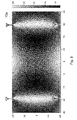
As one scenario related to the first embodiment, optimizing the three-dimensional position of
本シナリオにおいて、センサ50は、電磁波を受信するアンテナを有する無線受信局(電波センサ)に相当し得る。各センサ50は、例えば、未知の位置Φに存在する送信源から受信される電磁波の受信強度を測定し、受信強度を示す測定データmn(Φ)を生成する。センサ50は互いに時間的に同期しており、各センサ50は、対応する測定時刻を示すタイムスタンプを測定データmn(Φ)に含める。そして、各センサ50は、測定データmn(Φ)を推定サーバ60へ送信する。測定データは、例えば、無線LAN(Local Area Network)接続若しくは(LTE(Long Term Evolution)、LTE-A若しくは5Gなどの)セルラー接続といった無線接続を介して送信されてもよく、又は有線接続(例えば、Ethernet接続)を介して送信されてもよい。In this scenario,
推定サーバ60は、1つ以上の無線受信局から収集される測定データに基づいて、対象空間10内の送信源の位置を推定する。この場合、推定される状態S(Φ)は、送信源の位置Φそのものである。設計支援装置100は、推定サーバ60による位置推定の際に最も良好な精度を期待することのできるセンサ50の最適な配置を判定する。即ち、設計支援装置100は、N個のセンサ50の3次元座標[xn1,xn2,xn3](n=1,…,N)から構成されるセンサ構成セットを最適化する。
一例として、対象空間10における電磁波の伝搬距離と受信強度との関係を表す伝搬モデルは、次式のように定義される:
As an example, a propagation model representing the relationship between the propagation distance and reception intensity of electromagnetic waves in the

式(6)において、αは電磁波の送信レベルに関連付けられる係数であり、βは単位距離当たりの減衰率に関連付けられるパラメータである。dn(Φ)は、n番目のセンサ50の位置[xn1,xn2,xn3]と送信源の位置Φ=[x,y,z]との間の距離を表す。In Equation (6), α is a coefficient associated with the transmission level of electromagnetic waves, and β is a parameter associated with the attenuation rate per unit distance. d n (Φ) represents the distance between the position [x n1 , x n2 , x n3 ] of the
ここで、多数の既知のサンプリング距離だけ離れた送信源から一定の送信レベルで送信される電磁波をセンサ50で受信した結果として、図5に示すような距離と受信強度との関係を表すグラフ61が得られたものとする。グラフ61の横軸は、既知の送信源とセンサ50との間の距離、縦軸は受信信号強度を表す。グラフ61中にプロットされた点は、それぞれの測定値に対応する。そして、式(6)の伝搬モデルをグラフ61の測定値の集合にフィットするように例えば最小二乗法に従って分析することにより、伝搬モデルのモデルパラメータ(伝搬定数)α及びβを導出することができる。実線62は、導出されたモデルパラメータα及びβにより決定される伝搬モデルを表す。
Here, as a result of receiving by the
グラフ61を参照すると、測定値は、伝搬モデル62の周囲に誤差を含んで分布している。この誤差の主要な原因の1つは、伝搬環境におけるマルチパスフェージングである。即ち、電磁波は、送信源からセンサ50へ直接波として伝搬するだけでなく、建物、地面、往来する車両及び人によって反射され反射波としても伝搬する。こうした伝搬環境の大小様々な変化を、確率分布を通じてモデル化することで取り扱うことができる。
Referring to the
実測された測定データを伝搬モデル62に沿った値で正規化すると、正規化された受信強度の確率密度分布が得られる。一例として、卓越した直接波が存在せず数多くの散乱波が受信されるマルチパスフェージング環境はレイリーフェージング環境と呼ばれ、レイリーフェージング環境において観測される受信強度の二乗に相当する物理量の確率密度分布は指数関数となることが知られている。他の例として、レイリーフェージング環境に定常波が1つ加わった状況で観測される受信強度の確率密度分布は仲上-ライス分布となることが知られている。ここでは、簡明さのために、全てのセンサ50の全てのサブ領域についてレイリーフェージング環境を仮定し、次のような指数関数型の確率密度分布を用いるものとする:
When the actually measured data is normalized by the values according to the

式(7)の確率密度分布は、n番目のセンサ50において未知の送信源から電磁波が受信された場合の、対象空間10内の位置Φに送信源が存在する尤度ln(mn|Φ)を表しているとも言える。これを対象空間10内の任意の地点について算出すると、センサ50の各々について送信源の位置の尤度分布が導出される。そして、全てのセンサ50についての尤度分布を乗算することで、センシングシステム1全体の結合尤度分布が得られる。推定サーバ60は、例えばこうした対象空間10の結合尤度分布(尤度マップともいう)において最も高い尤度を示す地点に送信源が位置しているものと推定し得る。The probability density distribution of equation (7) is the likelihood l n (m n | Φ). By calculating this for an arbitrary point in the
さらに、式(7)の確率密度分布を式(3)へ代入すると、次のような推定精度の空間分布モデルA(Φ)が得られる: Furthermore, substituting the probability density distribution of equation (7) into equation (3) yields a spatial distribution model A(Φ) with the following estimation accuracy:

式(8)は、対象空間10内の位置Φに推定対象20が存在すると仮定した場合の位置推定の誤差の分散の下限値を表すことから、その値が小さいほど良好な推定精度を期待し得る。代表統計量として推定精度の空間分布の平均値を選択すると、最適化の目的関数は次のように表され得る:
Equation (8) represents the lower limit of the variance of the position estimation error when it is assumed that the

本シナリオにおいて、設計支援装置100は、センサ50の3次元位置を最適化するために、式(9)の目的関数を最小化するセンサ構成セット(具体的には、N個のセンサ50の3次元座標[xn1,xn2,xn3](n=1,…,N))を決定する。In this scenario, the
図6は、上述した位置推定のシナリオにおける一実施例について説明するための説明図である。図6に示したように、一例として、2次元のX-Y座標系においてX方向に80m、Y方向に40mの幅をそれぞれ有する対象空間10aにおいて、4つのセンサを用いて位置推定が行われるものとする。ここでは、より説明を簡明にするために、高さを考慮しない。対象空間10aにおいて電磁波を遮る障害物が存在しなければ、電磁波の自由空間伝播を仮定して、式(6)のモデルパラメータβの値をβ=2に設定することができる。モデルパラメータαは後の式展開において消失することから、モデルパラメータαの値は考慮されなくてよい。マルチパスフェージング環境としてレイリーフェージング環境を仮定すると、推定誤差の確率密度分布は次式の通りとなる:
FIG. 6 is an explanatory diagram for explaining an example of the scenario of position estimation described above. As shown in FIG. 6, as an example, position estimation is performed using four sensors in a

設計支援装置100は、例えばこの確率密度分布を用いて、上で説明した原理に従って最適構成判定処理を実行する。センサ構成セットの初期値はランダムに決定されてよく、例えば次のような値をとる:
(x1,y1)=(-35,-15)
(x2,y2)=(-30,18)
(x3,y3)=(20,18)
(x4,y4)=(38,-10)
次いで、式(10)を式(8)へ代入すると、図7に示したような推定精度の空間分布が算出される。本実施例では、対象空間10aのそれぞれの地点における推定精度の誤差の標準偏差が評価されることになり、図7のマップにおいてドットの密度が高い(色が濃い)地点ほどより良好な推定精度(より低い誤差)を期待することができる。The
(x 1 ,y 1 )=(-35,-15)
(x 2 ,y 2 )=(−30,18)
( x3 ,y3)=( 20,18 )
(x 4 ,y 4 )=(38,−10)
Then, by substituting equation (10) into equation (8), the spatial distribution of estimation accuracy as shown in FIG. 7 is calculated. In this embodiment, the standard deviation of the estimation accuracy error at each point in the
次いで、代表統計量の第1の例として対象空間10aの全体にわたる推定精度の平均値を、第2の例として対象空間10aの全体にわたる推定精度の最大値を例示する。図7のケースでは、推定精度の平均値は18.8m、最大値は40.9mに等しい。
Next, the average value of estimation accuracy over the
図8は、代表統計量として平均値を選択した場合(第1の例)の、代表統計量を最小化するセンサ配置の探索結果の一例を示している。なお、ここでは最適化アルゴリズムとして記憶制限付きBFGS法が使用された。探索結果として得られた4つのセンサの配置は次の通りであった:
(x1,y1)=(-23.0,-17.4)
(x2,y2)=(-13.6,3.3)
(x3,y3)=(12.2,7.0)
(x4,y4)=(33.8,-2.3)FIG. 8 shows an example of search results for sensor placement that minimizes the representative statistic when the average value is selected as the representative statistic (first example). Note that the memory-limited BFGS method was used here as the optimization algorithm. The layout of the four sensors obtained as a result of the search was as follows:
(x 1 , y 1 )=(-23.0,-17.4)
(x 2 , y 2 )=(-13.6, 3.3)
( x3 , y3) = (12.2, 7.0)
( x4,y4)= ( 33.8,-2.3)
図9は、代表統計量として最大値を選択した場合(第2の例)の、代表統計量を最小化するセンサ配置の探索結果の一例を示している。図8の例と同様に、最適化アルゴリズムとして記憶制限付きBFGS法が使用された。探索結果として得られた4つのセンサの配置は次の通りであった:
(x1,y1)=(29.3,19.3)
(x2,y2)=(-29.3,19.3)
(x3,y3)=(29.3,-19.3)
(x4,y4)=(-29.3,-19.3)FIG. 9 shows an example of search results for sensor placement that minimizes the representative statistic when the maximum value is selected as the representative statistic (second example). As in the example of FIG. 8, the memory-limited BFGS method was used as the optimization algorithm. The layout of the four sensors obtained as a result of the search was as follows:
( x1 , y1 ) = (29.3, 19.3)
(x 2 , y 2 )=(-29.3, 19.3)
(x 3 ,y 3 )=(29.3,−19.3)
(x 4 ,y 4 )=(-29.3,-19.3)
推定精度の平均値に着目すると、図8のセンサ配置では14.7mであるのに対し図9のセンサ配置では19.0mであることから、図8のセンサ配置の方が良好であることが理解される。対照的に、推定精度の最大値に着目すると、図8のセンサ配置では60.1mであるのに対し図9のセンサ配置では24.1mであることから、図9のセンサ配置の方が良好であることが理解される。 Focusing on the average value of the estimation accuracy, the sensor arrangement in FIG. 8 is 14.7 m, while the sensor arrangement in FIG. 9 is 19.0 m. Therefore, the sensor arrangement in FIG. 8 is better. understood. In contrast, focusing on the maximum value of the estimation accuracy, the sensor arrangement in FIG. 8 is 60.1 m, whereas the sensor arrangement in FIG. 9 is 24.1 m, so the sensor arrangement in FIG. 9 is better. It is understood that
このように、本実施形態によれば、対象空間における状態推定の誤差の解析を通じて、最適なセンサ構成セットを客観的かつ定量的に決定することが可能である。 Thus, according to this embodiment, it is possible to objectively and quantitatively determine the optimal sensor configuration set through analysis of state estimation errors in the target space.
<<3.第2の実施形態>>
第1の実施形態によれば、設計支援装置100は、センサの個数を所与として最適なセンサ構成セットを判定する。ここで、上述したように、配置されるセンサの個数とシステム配備のコストとがトレードオフの関係にあることを考慮すると、センサの個数をも最適化できれば、十分な推定精度と合理的なコストとを両立できる点で有利である。そこで、本節では、上述した原理を利用してセンサの個数をも最適化するための仕組みを説明する。<<3. Second Embodiment>>
According to the first embodiment, the
<3-1.設計支援装置の構成>
図10は、第2の実施形態に係る設計支援装置200の構成の一例を示すブロック図である。設計支援装置200は、図1を用いて説明したセンシングシステム1と同様のシステムにおいて、設計支援装置100の代わりに利用され得る。図10を参照すると、設計支援装置200は、処理部210、記憶部120、通信I/F130及びユーザI/F140を備える。<3-1. Configuration of Design Support Device>
FIG. 10 is a block diagram showing an example configuration of a
処理部210は、例えば、CPU、MPU又はマイクロコントローラといった少なくとも1つのプロセッサを含み得る。処理部210は、記憶部120により記憶されるコンピュータプログラムを実行することにより、設計支援装置200の論理的な機能を提供する。図10を参照すると、処理部210は、論理的な機能モジュールとして、モデル取得部150、統計量算出部160、最適化部170及び個数判定部280を含む。
モデル取得部150は、上述したように、1つ以上のセンサ50を用いて行われる推定対象20の状態に関する推定の推定精度の空間分布モデルを取得する、ように構成される。空間分布モデルは、例えば、測定誤差の確率密度分布の複数のセンサ50にわたる結合分布を用いて構築される、誤差の分散の下限を与える関数(推定対象20の位置の関数)として定義されてよい。統計量算出部160は、状態推定の推定精度を評価するための代表統計量を、モデル取得部150により取得される空間分布モデルに基づいて算出する、ように構成される。最適化部170は、1つ以上のセンサ50の異なる複数のセンサ構成セットについてそれぞれ統計量算出部160により算出される代表統計量に基づいて、1つ以上のセンサ50の最適なセンサ構成セットを判定する。
The
個数判定部280は、状態推定の推定精度に関する所定の条件を満たす最小のセンサ個数を判定する。概して、配置されるセンサの個数が多いほど状態推定の推定精度は高まる。一方、より多くのセンサを配置することはより大きいコストが掛かることを意味する。そこで、個数判定部280は、センサ個数を逓増させつつ、各センサ個数について最適化部170により判定される最適なセンサ構成セットに対応する、統計量算出部160により算出される代表統計量(以下、最適化済み代表統計量という)が所定の判定条件を満たすかを判定することにより、配置されるべきセンサの最適な個数を判定する。この場合、最初に判定条件を満たしたセンサ個数が、最適な個数となる。例えば、センサ個数nが次のうちのいずれか1つの条件又は2つ以上の条件の組み合わせを満たす場合に、nが最適な個数であると判定されてもよい:
・センサ個数nの最適化済み代表統計量が予め決定される閾値を下回る(代表統計量が小さいほど推定精度が高い場合);
・センサ個数nの最適化済み代表統計量が予め決定される閾値を上回る(代表統計量が大きいほど推定精度が高い場合);
・センサ個数nの最適化済み代表統計量とセンサ個数n+1の最適化済み代表統計量との差が予め決定される閾値を下回る。The
- The optimized representative statistic for the number of sensors n is below a predetermined threshold (when the smaller the representative statistic, the higher the estimation accuracy);
- The optimized representative statistic for the number of sensors n exceeds a predetermined threshold (when the larger the representative statistic, the higher the estimation accuracy);
- The difference between the optimized representative statistic for the number of sensors n and the optimized representative statistic for the number of sensors n+1 is below a predetermined threshold.
<3-2.処理の流れ>
図11は、第2の実施形態に係る設計支援装置200により実行され得る個数判定処理の流れの一例を示すフローチャートである。<3-2. Process Flow>
FIG. 11 is a flowchart showing an example of the flow of number determination processing that can be executed by the
まず、最適化部170は、探索条件を設定する(ステップS210)。例えば、探索条件は、対象空間10の空間的範囲を含む。また、個数判定部280は、センサ個数を初期化する(ステップS220)。センサ個数は、十分に小さい任意の値へ初期化されてよい。
First, the
次いで、最適化部170は、センサ構成セットを初期化する(ステップS230)。センサ構成セットに含まれるパラメータの初期値は、対応するレンジ内のいかなる値であってもよい。
The
次いで、モデル取得部150は、ステップS230において初期化され又は後述するステップS270において更新されたセンサ構成セットを所与として、現時点の個数のセンサを用いて行われる状態推定の推定精度の空間分布モデルを取得する(ステップS240)。
Then, given the sensor configuration set initialized in step S230 or updated in step S270, which will be described later, the
次いで、統計量算出部160は、ステップS240において取得された空間分布モデルに基づいて、状態推定の推定精度を評価するための代表統計量を算出する(ステップS250)。
Next, the
最適化部170は、ステップS240及びS250の反復において算出される代表統計量が収束したか否かを判定する(ステップS260)。代表統計量が収束したと判定される場合には、最適化部170は、収束時点のセンサ構成セットが現時点のセンサ個数について最適なセンサ構成セットであると判定する。一方、代表統計量が収束したと判定されない場合には、最適化部170は、センサ構成セットを更新して(ステップS270)、モデル取得部150及び統計量算出部160に次回の反復を遂行させる。
The
次いで、個数判定部280は、判定された最適なセンサ構成セットに対応する代表統計量(最適化済み代表統計量)が所定の条件を満たすか(例えば、予め決定される閾値を下回るか)を判定する(ステップS280)。所定の条件が満たされると判定される場合には、個数判定部280は、現時点のセンサ個数が最適な個数であると判定し、最適なセンサ個数(及び対応するセンサ構成セット)を処理の結果として出力する。一方、所定の条件が満たされないと判定される場合には、個数判定部280は、センサ個数を逓増して(ステップS290)、新たなセンサ個数について上述したステップS230~S270を実行させる。
Next, the
<3-3.実施例>
第2の実施形態の一実施例として、図6を用いて説明した対象空間10aにおいて、ある閾値レベルを満たす推定精度を期待することのできるセンサ個数の最小値を導出することを検討する。<3-3. Example>
As an example of the second embodiment, derivation of the minimum number of sensors for which estimation accuracy satisfying a certain threshold level can be expected in the
上で式(8)に示した空間分布モデルA(Φ)の値は推定誤差の分散の期待値を意味することから、その平方根を状態推定の精度を表す指標として扱うことができる。例えば、対象空間10aについて、センサ個数の初期値を4、代表統計量として平均値を選択して、図11を用いて説明した個数判定処理を実行した結果を図12に示す。図12の横軸はセンサ個数、縦軸は最適化済み代表統計量を表し、ここでは最適化済み代表統計量は推定誤差の分布の空間平均である。例えば、最適化済み代表統計量が8dBmを下回るという判定条件が与えられる場合、図12の結果によれば、最適なセンサ個数は8個である。また、最適化済み代表統計量が6dBmを下回るという判定条件が与えられる場合、図12の結果によれば、最適なセンサ個数は12個である。
Since the value of the spatial distribution model A(Φ) shown in Equation (8) above means the expected value of the variance of the estimation error, its square root can be treated as an index representing the accuracy of state estimation. For example, for the
このように、本実施形態によれば、対象空間における状態推定の誤差の解析を通じて、対象空間に配置されるべきセンサの個数を最適化して、十分な推定精度とセンシングシステムの配備のための合理的なコストとを両立することが可能である。 In this way, according to the present embodiment, the number of sensors to be arranged in the target space is optimized through analysis of state estimation errors in the target space, and sufficient estimation accuracy and rationality for deployment of the sensing system are achieved. It is possible to achieve both a reasonable cost.
<<4.まとめ>>
ここまで、図1~図12を用いて本開示に係る技術のいくつかの実施形態について詳細に説明した。上述した実施形態では、1つ以上のセンサを用いて行われる対象の状態に関する推定の推定精度の空間分布モデルに基づいて、推定精度を評価するための代表統計量が算出され、異なる複数のセンサ構成セットについてそれぞれ算出される代表統計量に基づいて、最適なセンサ構成セットが判定される。かかる構成によれば、システム配備の際に経験則に基づいて又は試行錯誤を通じてセンサが配置されるケースと比較して、より効率的に又は自動的にセンサ構成を最適化することができる。<<4. Summary>>
So far, several embodiments of the technology according to the present disclosure have been described in detail using FIGS. 1 to 12. FIG. In the above-described embodiment, a representative statistic for evaluating the estimation accuracy is calculated based on the spatial distribution model of the estimation accuracy of the estimation about the state of the object performed using one or more sensors, and a plurality of different sensors An optimal sensor configuration set is determined based on representative statistics calculated for each configuration set. With such a configuration, the sensor configuration can be optimized more efficiently or automatically as compared to the case where the sensors are placed empirically or through trial and error during system deployment.
ある例において、推定精度の空間分布モデルは、測定誤差の確率密度分布の複数のセンサにわたる結合分布を用いて構築され得る。したがって、対象空間をカバーするために多数のセンサが配置されるような状況においても、客観的かつ定量的な評価に基づいて最適なセンサ構成セットを判定することができる。こうした手法は、対象空間の形状に関わらず利用可能である点においても有益である。 In one example, a spatial distribution model of the estimated accuracy can be constructed using a joint distribution across multiple sensors of the probability density distribution of the measurement error. Therefore, even in situations where a large number of sensors are deployed to cover the target space, the optimal sensor configuration set can be determined based on objective and quantitative evaluation. Such a method is also useful in that it can be used regardless of the shape of the target space.
また、上記空間分布モデルは、上記結合分布に応じて誤差の分散の下限を与える、推定対象の位置の関数であってよい。この場合、誤差の分散の下限を推定精度の期待値であると見なして、最適なセンサ構成セットの導出を推定精度を最適化するための最適化問題にモデル化することができる。したがって、既存の最適化アルゴリズムを活用して上述した仕組みをコンピュータに実装することが可能である。 Also, the spatial distribution model may be a function of the position of the object to be estimated that gives a lower bound on the variance of the error according to the joint distribution. In this case, the derivation of the optimal sensor configuration set can be modeled as an optimization problem for optimizing the estimation accuracy, taking the lower bound of the error variance as the expected value of the estimation accuracy. Therefore, it is possible to implement the mechanism described above in a computer by utilizing an existing optimization algorithm.
ある例において、推定対象の状態は、推定対象の位置を含み得る。したがって、本開示に係る技術は、不法な電磁波の送信源の特定、遭難者の救助、不審な船舶の発見、魚群の探知、又は衛星による地表の観測などを含む多様な位置推定の場面に広く適用可能である。 In one example, the estimated state may include the estimated location. Therefore, the technology according to the present disclosure is widely used in various situations of position estimation including identification of sources of illegal electromagnetic waves, rescue of distressed persons, detection of suspicious vessels, detection of schools of fish, and observation of the earth's surface by satellites. Applicable.
ある実施形態では、異なるセンサ個数についてそれぞれ判定される最適なセンサ構成セットに基づいて、推定対象の状態を推定するために配置されるべきセンサの個数がさらに判定される。かかる構成によれば、高い推定精度を得るために過度に多くのセンサを配置してしまうといった無駄を回避すること、及び限られた数のセンサを適切に構成することができる。即ち、十分な推定精度と合理的なコストとの両立が可能となる。 In some embodiments, the number of sensors to be deployed to estimate the state of interest is further determined based on the optimal sensor configuration sets determined for each different number of sensors. According to such a configuration, it is possible to avoid waste such as arranging an excessive number of sensors in order to obtain high estimation accuracy, and to appropriately configure a limited number of sensors. That is, it is possible to achieve both sufficient estimation accuracy and reasonable cost.
なお、本開示に係る技術は、上述した実施形態に限定されるものではない。これらの実施形態は例示にすぎないということ、及び、本開示のスコープ及び精神から逸脱することなく様々な変形が可能であるということは、当業者に理解されるであろう。 Note that the technology according to the present disclosure is not limited to the above-described embodiments. Those skilled in the art will appreciate that these embodiments are illustrative only and that various modifications are possible without departing from the scope and spirit of the disclosure.
例えば、フローチャートに示した処理ステップは、必ずしも図示した順序通りに実行されなくてもよい。例えば、処理ステップは図示した順序とは異なる順序で実行されてもよく、2つ以上の処理ステップが並列的に実行されてもよい。また、一部の処理ステップが削除されてもよく、さらなる処理ステップが追加されてもよい。 For example, the process steps shown in the flowcharts do not necessarily have to be performed in the order shown. For example, the processing steps may be performed in a different order than shown, and two or more processing steps may be performed in parallel. Also, some processing steps may be deleted and further processing steps may be added.
また、本明細書において説明した装置の機能は、ソフトウェア、ハードウェア、及びソフトウェアとハードウェアとの組み合わせのいずれで実現されてもよい。ソフトウェアを構成するコンピュータプログラムのプログラム命令は、例えば、各装置の内部又は外部のコンピュータ読取可能な記憶媒体において記憶され、実行時にメモリに読み込まれてプロセッサにより実行される。 Also, the functions of the apparatus described herein may be implemented in software, hardware, or a combination of software and hardware. Program instructions of a computer program constituting software are stored, for example, in a computer-readable storage medium inside or outside each device, read into a memory at execution time, and executed by a processor.
上記実施形態の一部又は全部は、以下の付記のようにも記載され得るが、以下には限られない。 Some or all of the above embodiments may also be described in the following additional remarks, but are not limited to the following.
(付記1)
1つ以上のセンサを用いて行われる対象の状態に関する推定の推定精度の空間分布モデルを取得する取得部と、
前記推定精度を評価するための代表統計量を、取得される前記空間分布モデルに基づいて算出する算出部と、
前記1つ以上のセンサの異なる複数のセンサ構成セットについてそれぞれ算出される前記代表統計量に基づいて、前記1つ以上のセンサの最適なセンサ構成セットを判定する最適化部と、
を備える情報処理装置。(Appendix 1)
an acquisition unit that acquires a spatial distribution model of the estimated accuracy of an estimate of the state of interest made using one or more sensors;
a calculation unit that calculates a representative statistic for evaluating the estimation accuracy based on the acquired spatial distribution model;
an optimization unit that determines an optimal sensor configuration set for the one or more sensors based on the representative statistics calculated for a plurality of different sensor configuration sets for the one or more sensors;
Information processing device.
(付記2)
異なるセンサ個数についてそれぞれ判定される最適なセンサ構成セットに基づいて、前記対象の前記状態を推定するために配置されるべき前記センサの個数を判定する個数判定部、をさらに備える、付記1に記載の情報処理装置。(Appendix 2)
2. The method of
(付記3)
前記個数判定部は、各センサ個数について判定される前記最適なセンサ構成セットに対応する前記代表統計量が所定の条件を満たすかを判定することにより、配置されるべき前記センサの個数を判定する、付記2に記載の情報処理装置。(Appendix 3)
The number determination unit determines the number of sensors to be arranged by determining whether the representative statistic corresponding to the optimum sensor configuration set determined for each number of sensors satisfies a predetermined condition. , the information processing apparatus according to appendix 2.
(付記4)
前記取得部は、測定誤差の確率密度分布の複数のセンサにわたる結合分布を用いて前記空間分布モデルを構築することにより、前記空間分布モデルを取得する、付記1~3のいずれか1項に記載の情報処理装置。(Appendix 4)
4. The acquisition unit acquires the spatial distribution model by constructing the spatial distribution model using a joint distribution over a plurality of sensors of probability density distributions of measurement errors. information processing equipment.
(付記5)
前記空間分布モデルは、前記結合分布に応じて誤差の分散の下限を与える、前記対象の位置の関数である、付記4に記載の情報処理装置。(Appendix 5)
5. The information processing apparatus according to
(付記6)
前記対象の前記状態は、前記対象の位置を含む、付記1~5のいずれか1項に記載の情報処理装置。(Appendix 6)
6. The information processing apparatus according to any one of
(付記7)
前記センサ構成セットは、前記1つ以上のセンサの各々について、2次元位置又は3次元位置、向き、受信感度、及び信号増幅率、のうちの少なくとも1つを含む、付記1~6のいずれか1項に記載の情報処理装置。(Appendix 7)
7. Any of Clauses 1-6, wherein the sensor configuration set includes at least one of two-dimensional or three-dimensional position, orientation, receive sensitivity, and signal amplification factor for each of the one or more sensors. The information processing device according to
(付記8)
前記代表統計量は、対象空間にわたる前記推定精度の平均値、最大値、中央値又はパーセンタイル値である、付記1~7のいずれか1項に記載の情報処理装置。(Appendix 8)
8. The information processing apparatus according to any one of
(付記9)
前記1つ以上のセンサと、
前記1つ以上のセンサを用いて前記対象の前記状態を推定する推定装置と、
付記1~8のいずれか1項に記載の情報処理装置と、
を含むセンシングシステム。(Appendix 9)
the one or more sensors;
an estimating device that estimates the state of the object using the one or more sensors;
The information processing device according to any one of
Sensing system including.
(付記10)
1つ以上のセンサを用いて行われる対象の状態に関する推定の推定精度の空間分布モデルを取得することと、
前記推定精度を評価するための代表統計量を、取得される前記空間分布モデルに基づいて算出することと、
前記1つ以上のセンサの異なる複数のセンサ構成セットについてそれぞれ算出される前記代表統計量に基づいて、前記1つ以上のセンサの最適なセンサ構成セットを判定することと、
を含む方法。(Appendix 10)
obtaining a spatial distribution model of the estimated accuracy of an estimate of the state of interest made using one or more sensors;
Calculating a representative statistic for evaluating the estimation accuracy based on the acquired spatial distribution model;
Determining an optimal sensor configuration set for the one or more sensors based on the representative statistics calculated for each of a plurality of different sensor configuration sets for the one or more sensors;
method including.
(付記11)
1つ以上のセンサを用いて行われる対象の状態に関する推定の推定精度の空間分布モデルを取得することと、
前記推定精度を評価するための代表統計量を、取得される前記空間分布モデルに基づいて算出することと、
前記1つ以上のセンサの異なる複数のセンサ構成セットについてそれぞれ算出される前記代表統計量に基づいて、前記1つ以上のセンサの最適なセンサ構成セットを判定することと、
をプロセッサに実行させるコンピュータプログラム。(Appendix 11)
obtaining a spatial distribution model of the estimated accuracy of an estimate of the state of interest made using one or more sensors;
Calculating a representative statistic for evaluating the estimation accuracy based on the acquired spatial distribution model;
Determining an optimal sensor configuration set for the one or more sensors based on the representative statistics calculated for different sensor configuration sets for the one or more sensors;
A computer program that causes a processor to execute
(付記12)
1つ以上のセンサを用いて行われる対象の状態に関する推定の推定精度の空間分布モデルを取得することと、
前記推定精度を評価するための代表統計量を、取得される前記空間分布モデルに基づいて算出することと、
前記1つ以上のセンサの異なる複数のセンサ構成セットについてそれぞれ算出される前記代表統計量に基づいて、前記1つ以上のセンサの最適なセンサ構成セットを判定することと、
をプロセッサに実行させるコンピュータプログラムを記憶した非一時的なコンピュータ読取可能な記憶媒体。(Appendix 12)
obtaining a spatial distribution model of the estimated accuracy of an estimate of the state of interest made using one or more sensors;
Calculating a representative statistic for evaluating the estimation accuracy based on the acquired spatial distribution model;
Determining an optimal sensor configuration set for the one or more sensors based on the representative statistics calculated for different sensor configuration sets for the one or more sensors;
A non-transitory computer-readable storage medium storing a computer program that causes a processor to execute
この出願は、2018年10月15日に出願された日本出願特願2018-194397を基礎とする優先権を主張し、その開示の全てをここに取り込む。 This application claims priority based on Japanese Patent Application No. 2018-194397 filed on October 15, 2018, and the entire disclosure thereof is incorporated herein.
本開示に係る技術は、限定ではないものの、センサを用いて対象の状態を推定しようとするセンシングシステムにおいてセンサ構成を効率的に設計するために利用可能である。 Techniques of the present disclosure can be used, without limitation, to efficiently design sensor configurations in sensing systems that use sensors to attempt to estimate the state of an object.
1 センシングシステム
10 対象空間
20 推定対象
50(50a~d) センサ
60 推定サーバ
100,200 設計支援装置(情報処理装置)
110,210 処理部
120 記憶部
130 通信インタフェース
140 ユーザインタフェース
150 モデル取得部
160 統計量算出部
170 最適化部
280 個数判定部
1 sensing
110, 210
Claims (10)
前記推定精度を評価するための代表統計量を、取得される前記空間分布モデルに基づいて算出する算出手段と、
前記複数のセンサの異なる複数のセンサ構成セットについてそれぞれ算出される前記代表統計量に基づいて、前記複数のセンサの最適なセンサ構成セットを判定する最適化手段と、
を備える情報処理装置。 Acquisition means for acquiring a spatial distribution model of the estimated accuracy of an estimate of a state of interest made using a plurality of sensors;
a calculation means for calculating a representative statistic for evaluating the estimation accuracy based on the obtained spatial distribution model;
optimization means for determining an optimum sensor configuration set for the plurality of sensors based on the representative statistics calculated for the plurality of different sensor configuration sets for the plurality of sensors;
Information processing device.
前記複数のセンサを用いて前記対象の前記状態を推定する推定装置と、
請求項1~7のいずれか1項に記載の情報処理装置と、
を含むセンシングシステム。 the plurality of sensors;
an estimating device that estimates the state of the target using the plurality of sensors;
The information processing device according to any one of claims 1 to 7,
Sensing system including.
前記推定精度を評価するための代表統計量を、取得される前記空間分布モデルに基づいて算出することと、
前記複数のセンサの異なる複数のセンサ構成セットについてそれぞれ算出される前記代表統計量に基づいて、前記複数のセンサの最適なセンサ構成セットを判定することと、
を含む方法。 obtaining a spatial distribution model of the estimated accuracy of an estimate of the state of interest made using a plurality of sensors;
Calculating a representative statistic for evaluating the estimation accuracy based on the acquired spatial distribution model;
Determining an optimal sensor configuration set for the plurality of sensors based on the representative statistics calculated for the plurality of different sensor configuration sets for the plurality of sensors;
method including.
前記推定精度を評価するための代表統計量を、取得される前記空間分布モデルに基づいて算出することと、
前記複数のセンサの異なる複数のセンサ構成セットについてそれぞれ算出される前記代表統計量に基づいて、前記複数のセンサの最適なセンサ構成セットを判定することと、
をプロセッサに実行させるコンピュータプログラム。 obtaining a spatial distribution model of the estimated accuracy of an estimate of the state of interest made using a plurality of sensors;
Calculating a representative statistic for evaluating the estimation accuracy based on the acquired spatial distribution model;
Determining an optimal sensor configuration set for the plurality of sensors based on the representative statistics calculated for the plurality of different sensor configuration sets for the plurality of sensors;
A computer program that causes a processor to execute
Applications Claiming Priority (3)
| Application Number | Priority Date | Filing Date | Title |
|---|---|---|---|
| JP2018194397 | 2018-10-15 | ||
| JP2018194397 | 2018-10-15 | ||
| PCT/JP2019/039626 WO2020080180A1 (en) | 2018-10-15 | 2019-10-08 | Information processing device, sensing system, method, program, and storage medium |
Publications (2)
| Publication Number | Publication Date |
|---|---|
| JPWO2020080180A1 JPWO2020080180A1 (en) | 2021-09-09 |
| JP7173158B2 true JP7173158B2 (en) | 2022-11-16 |
Family
ID=70283047
Family Applications (1)
| Application Number | Title | Priority Date | Filing Date |
|---|---|---|---|
| JP2020553092A Active JP7173158B2 (en) | 2018-10-15 | 2019-10-08 | Information processing device, sensing system, method, and program |
Country Status (3)
| Country | Link |
|---|---|
| US (1) | US20210356552A1 (en) |
| JP (1) | JP7173158B2 (en) |
| WO (1) | WO2020080180A1 (en) |
Families Citing this family (3)
| Publication number | Priority date | Publication date | Assignee | Title |
|---|---|---|---|---|
| JP7465155B2 (en) * | 2020-06-11 | 2024-04-10 | 株式会社東海理化電機製作所 | Control device, control system, and program |
| JP7629707B2 (en) * | 2020-10-28 | 2025-02-14 | 株式会社日立製作所 | Positioning method |
| CN118886237B (en) * | 2024-10-09 | 2025-05-23 | 中国海洋大学 | Double-sensing side line array layout optimization method for underwater target positioning |
Citations (5)
| Publication number | Priority date | Publication date | Assignee | Title |
|---|---|---|---|---|
| JP2001174339A (en) | 1999-10-21 | 2001-06-29 | Korea Advanced Inst Of Sci Technol | Optimal Positioning Method of Sensor for Temperature Measurement Using Sound Wave |
| US8077091B1 (en) | 2010-07-06 | 2011-12-13 | Intelligent Sciences, Ltd. | System and method for determining a position of a mobile device within a surveillance volume in the presence of multipath interference |
| JP2013544449A (en) | 2010-09-08 | 2013-12-12 | マイクロソフト コーポレーション | Depth camera based on structured light and stereoscopic vision |
| WO2014045521A1 (en) | 2012-09-19 | 2014-03-27 | 日本電気株式会社 | Placement score calculation system, method, and program |
| JP7135427B2 (en) | 2018-05-15 | 2022-09-13 | 日本電気株式会社 | Processor, method, program and system |
Family Cites Families (8)
| Publication number | Priority date | Publication date | Assignee | Title |
|---|---|---|---|---|
| JP3696926B2 (en) * | 1995-06-14 | 2005-09-21 | キヤノン株式会社 | Active vibration isolation device and sensor placement method for the device |
| PT1788461E (en) * | 2005-11-22 | 2009-09-24 | Faculte Polytechnique De Mons | A device for and a method of designing a sensor arrangement for a safe automated system, an automated system, a program element and a computer-readable medium |
| EP2799902A1 (en) * | 2013-04-30 | 2014-11-05 | Baselabs GmbH | Method and apparatus for the tracking of multiple objects |
| DE102014005181A1 (en) * | 2014-04-03 | 2015-10-08 | Astrium Gmbh | Position and orientation of objects |
| US9840256B1 (en) * | 2015-12-16 | 2017-12-12 | Uber Technologies, Inc. | Predictive sensor array configuration system for an autonomous vehicle |
| JP6767194B2 (en) * | 2016-08-01 | 2020-10-14 | 株式会社東芝 | Information collection support device, information collection support method and computer program |
| US20180372874A1 (en) * | 2017-06-26 | 2018-12-27 | GM Global Technology Operations LLC | Apparatus for mechanical scanning scheme for lidar illuminator |
| JP2019086506A (en) * | 2017-11-02 | 2019-06-06 | 日本電信電話株式会社 | Estimation device, estimation method and program |
-
2019
- 2019-10-08 JP JP2020553092A patent/JP7173158B2/en active Active
- 2019-10-08 WO PCT/JP2019/039626 patent/WO2020080180A1/en not_active Ceased
- 2019-10-08 US US17/282,497 patent/US20210356552A1/en not_active Abandoned
Patent Citations (5)
| Publication number | Priority date | Publication date | Assignee | Title |
|---|---|---|---|---|
| JP2001174339A (en) | 1999-10-21 | 2001-06-29 | Korea Advanced Inst Of Sci Technol | Optimal Positioning Method of Sensor for Temperature Measurement Using Sound Wave |
| US8077091B1 (en) | 2010-07-06 | 2011-12-13 | Intelligent Sciences, Ltd. | System and method for determining a position of a mobile device within a surveillance volume in the presence of multipath interference |
| JP2013544449A (en) | 2010-09-08 | 2013-12-12 | マイクロソフト コーポレーション | Depth camera based on structured light and stereoscopic vision |
| WO2014045521A1 (en) | 2012-09-19 | 2014-03-27 | 日本電気株式会社 | Placement score calculation system, method, and program |
| JP7135427B2 (en) | 2018-05-15 | 2022-09-13 | 日本電気株式会社 | Processor, method, program and system |
Non-Patent Citations (1)
| Title |
|---|
| 徳永雄一,伊戸靖則,平岡精一,横田裕介,大久保英嗣,「無線センサネットワークにおけるMultilateration位置推定法の精度向上手法」,電子情報通信学会論文誌B,社団法人電子情報通信学会,2008年09月01日,Vol.J91-B, No.9,pp.1113-1124 |
Also Published As
| Publication number | Publication date |
|---|---|
| WO2020080180A1 (en) | 2020-04-23 |
| US20210356552A1 (en) | 2021-11-18 |
| JPWO2020080180A1 (en) | 2021-09-09 |
Similar Documents
| Publication | Publication Date | Title |
|---|---|---|
| CN114729982B (en) | Method and device for positioning | |
| US10306405B2 (en) | Determining the geographic location of a portable electronic device | |
| US11209536B2 (en) | Method and apparatus for tracking motion using radio frequency signals | |
| Hanssens et al. | An indoor variance-based localization technique utilizing the UWB estimation of geometrical propagation parameters | |
| KR101234177B1 (en) | Method for estimating position of user device | |
| JP7173158B2 (en) | Information processing device, sensing system, method, and program | |
| Mukhopadhyay et al. | Performance evaluation of localization techniques in wireless sensor networks using RSSI and LQI | |
| Li et al. | TDOA-based localization for semi-static targets in NLOS environments | |
| US10715263B2 (en) | Information processing apparatus, method and non-transitory computer-readable storage medium | |
| Colpaert et al. | 3D non-stationary channel measurement and analysis for MaMIMO-UAV communications | |
| Pagliari et al. | Wi-fi-based real-time uav localization: A comparative analysis between rssi-based and ftm-based approaches | |
| Kiring et al. | Wi-Fi radio map interpolation with sparse and correlated received signal strength measurements for indoor positioning | |
| JP2016520801A (en) | Transmitter directional pruning to improve position determination | |
| US12372603B2 (en) | Estimating a location of a user equipment | |
| CN112505624B (en) | A Positioning System Based on Environmental Backscatter | |
| EP4058820A1 (en) | Method and apparatus for kinematic state estimation of a user equipment | |
| Kim et al. | Geolocation in ad hoc networks using DS-CDMA and generalized successive interference cancellation | |
| JP6663098B2 (en) | Wave source position selection device, wave source position calculation device, wave source position selection method, wave source position calculation method, and program | |
| JP6331072B2 (en) | White space detection device, white space detection method, and program | |
| JP2019215183A (en) | Interference source searching method and interference source searching device | |
| CN107250831A (en) | The instruction of the direction of advance of mobile device is provided | |
| Rodas et al. | Bayesian filtering for a bluetooth positioning system | |
| Ahmad et al. | Experiments on localization of wireless sensors using airborne mobile anchors | |
| Uraiya et al. | Genetic algorithm for wireless sensor network with localization based techniques | |
| KR102577520B1 (en) | Method and apparatus of positioning for accommodating wireless-environment change |
Legal Events
| Date | Code | Title | Description |
|---|---|---|---|
| A521 | Request for written amendment filed |
Free format text: JAPANESE INTERMEDIATE CODE: A523 Effective date: 20210405 |
|
| A621 | Written request for application examination |
Free format text: JAPANESE INTERMEDIATE CODE: A621 Effective date: 20210405 |
|
| A131 | Notification of reasons for refusal |
Free format text: JAPANESE INTERMEDIATE CODE: A131 Effective date: 20220524 |
|
| A521 | Request for written amendment filed |
Free format text: JAPANESE INTERMEDIATE CODE: A523 Effective date: 20220711 |
|
| TRDD | Decision of grant or rejection written | ||
| A01 | Written decision to grant a patent or to grant a registration (utility model) |
Free format text: JAPANESE INTERMEDIATE CODE: A01 Effective date: 20221004 |
|
| A61 | First payment of annual fees (during grant procedure) |
Free format text: JAPANESE INTERMEDIATE CODE: A61 Effective date: 20221017 |
|
| R151 | Written notification of patent or utility model registration |
Ref document number: 7173158 Country of ref document: JP Free format text: JAPANESE INTERMEDIATE CODE: R151 |