JP6474011B2 - Method and mobile device for performing geofencing - Google Patents
Method and mobile device for performing geofencing Download PDFInfo
- Publication number
- JP6474011B2 JP6474011B2 JP2017532894A JP2017532894A JP6474011B2 JP 6474011 B2 JP6474011 B2 JP 6474011B2 JP 2017532894 A JP2017532894 A JP 2017532894A JP 2017532894 A JP2017532894 A JP 2017532894A JP 6474011 B2 JP6474011 B2 JP 6474011B2
- Authority
- JP
- Japan
- Prior art keywords
- coordinate system
- coordinate
- geofence
- coordinates
- positioning
- Prior art date
- Legal status (The legal status is an assumption and is not a legal conclusion. Google has not performed a legal analysis and makes no representation as to the accuracy of the status listed.)
- Active
Links
- 238000000034 method Methods 0.000 title claims description 76
- 238000004422 calculation algorithm Methods 0.000 claims description 16
- 230000001131 transforming effect Effects 0.000 claims description 2
- 238000006243 chemical reaction Methods 0.000 description 27
- 238000005516 engineering process Methods 0.000 description 14
- 230000009466 transformation Effects 0.000 description 11
- 238000012544 monitoring process Methods 0.000 description 10
- 230000008569 process Effects 0.000 description 8
- 238000010586 diagram Methods 0.000 description 7
- 230000006870 function Effects 0.000 description 6
- 238000001514 detection method Methods 0.000 description 5
- 238000012545 processing Methods 0.000 description 5
- 238000004891 communication Methods 0.000 description 3
- 230000008878 coupling Effects 0.000 description 3
- 238000010168 coupling process Methods 0.000 description 3
- 238000005859 coupling reaction Methods 0.000 description 3
- 230000005540 biological transmission Effects 0.000 description 1
- 238000004364 calculation method Methods 0.000 description 1
- 230000001413 cellular effect Effects 0.000 description 1
- 230000008859 change Effects 0.000 description 1
- 238000004590 computer program Methods 0.000 description 1
- 238000013507 mapping Methods 0.000 description 1
- 238000010295 mobile communication Methods 0.000 description 1
- 230000003287 optical effect Effects 0.000 description 1
- 230000001960 triggered effect Effects 0.000 description 1
Images


Classifications
-
- H—ELECTRICITY
- H04—ELECTRIC COMMUNICATION TECHNIQUE
- H04W—WIRELESS COMMUNICATION NETWORKS
- H04W4/00—Services specially adapted for wireless communication networks; Facilities therefor
- H04W4/02—Services making use of location information
- H04W4/021—Services related to particular areas, e.g. point of interest [POI] services, venue services or geofences
-
- H—ELECTRICITY
- H04—ELECTRIC COMMUNICATION TECHNIQUE
- H04W—WIRELESS COMMUNICATION NETWORKS
- H04W4/00—Services specially adapted for wireless communication networks; Facilities therefor
- H04W4/02—Services making use of location information
-
- H—ELECTRICITY
- H04—ELECTRIC COMMUNICATION TECHNIQUE
- H04W—WIRELESS COMMUNICATION NETWORKS
- H04W4/00—Services specially adapted for wireless communication networks; Facilities therefor
- H04W4/02—Services making use of location information
- H04W4/029—Location-based management or tracking services
-
- H—ELECTRICITY
- H04—ELECTRIC COMMUNICATION TECHNIQUE
- H04W—WIRELESS COMMUNICATION NETWORKS
- H04W4/00—Services specially adapted for wireless communication networks; Facilities therefor
- H04W4/02—Services making use of location information
- H04W4/023—Services making use of location information using mutual or relative location information between multiple location based services [LBS] targets or of distance thresholds
-
- H—ELECTRICITY
- H04—ELECTRIC COMMUNICATION TECHNIQUE
- H04W—WIRELESS COMMUNICATION NETWORKS
- H04W52/00—Power management, e.g. Transmission Power Control [TPC] or power classes
- H04W52/02—Power saving arrangements
- H04W52/0203—Power saving arrangements in the radio access network or backbone network of wireless communication networks
- H04W52/0206—Power saving arrangements in the radio access network or backbone network of wireless communication networks in access points, e.g. base stations
-
- Y—GENERAL TAGGING OF NEW TECHNOLOGICAL DEVELOPMENTS; GENERAL TAGGING OF CROSS-SECTIONAL TECHNOLOGIES SPANNING OVER SEVERAL SECTIONS OF THE IPC; TECHNICAL SUBJECTS COVERED BY FORMER USPC CROSS-REFERENCE ART COLLECTIONS [XRACs] AND DIGESTS
- Y02—TECHNOLOGIES OR APPLICATIONS FOR MITIGATION OR ADAPTATION AGAINST CLIMATE CHANGE
- Y02D—CLIMATE CHANGE MITIGATION TECHNOLOGIES IN INFORMATION AND COMMUNICATION TECHNOLOGIES [ICT], I.E. INFORMATION AND COMMUNICATION TECHNOLOGIES AIMING AT THE REDUCTION OF THEIR OWN ENERGY USE
- Y02D30/00—Reducing energy consumption in communication networks
- Y02D30/70—Reducing energy consumption in communication networks in wireless communication networks
Landscapes
- Engineering & Computer Science (AREA)
- Computer Networks & Wireless Communication (AREA)
- Signal Processing (AREA)
- Telephone Function (AREA)
- Mobile Radio Communication Systems (AREA)
- Position Fixing By Use Of Radio Waves (AREA)
Description
本発明は、移動通信の分野に関連し、特に、ジオフェンシングを実施するための方法及びモバイルデバイスに関する。 The present invention relates to the field of mobile communications, and more particularly to a method and mobile device for performing geofencing.
ジオフェンシング(Geo-fencing)は、モバイルデバイスと特定の地理的領域との間の関係を監視し、その関係に従って情報サービスを提供するための技術である。特定の地理的領域は、ジオフェンス(geo-fence)によって決定される。ジオフェンシングを実施するプロセスは通常以下の通りである:まず、ジオフェンスを確立し、次いで、リアルタイムの測位を開始し、その後、前記ジオフェンスの座標を測位結果の座標と比較して、モバイルデバイスが前記ジオフェンスの内部に又は外部に位置しているかどうかを判断し、最後に、リマインダや警告メッセージの送信や地図上の測位点の表示などの判断結果に従って対応する動作を実行する。 Geo-fencing is a technology for monitoring the relationship between a mobile device and a specific geographic region and providing information services according to that relationship. A particular geographic area is determined by a geo-fence. The process of performing geofencing is usually as follows: First, establish a geofence, then start real-time positioning, then compare the coordinates of the geofence with the coordinates of the positioning result, Is determined to be located inside or outside the geofence, and finally, a corresponding operation is executed according to a determination result such as transmission of a reminder or warning message or display of a positioning point on a map.
通常、ジオフェンスの座標と測位結果の座標は双方とも同じ座標系を使用する。しかし、実際のアプリケーションにおいて、前記ジオフェンスの座標系は、前記測位結果のそれとは整合しないことがしばしばあり、比較的大きな偏差がある。例えば、ユーザが、GCJ02、BD09、又はBD09LL座標系を使用して地図から直接地点を取得することによりジオフェンスを確立し、測位技術として全地球測位システム(英語:Global Positioning System, 略してGPS)を使用する場合には、前記ジオフェンスの座標系は、GPSを用いて取得された測位結果により使用される座標系WGS84とは異なる。 Usually, the coordinates of the geofence and the coordinates of the positioning result both use the same coordinate system. However, in actual applications, the coordinate system of the geofence often does not match that of the positioning result, and there is a relatively large deviation. For example, a user establishes a geofence by acquiring a point directly from a map using the GCJ02, BD09, or BD09LL coordinate system, and the global positioning system (English: Global Positioning System, GPS for short) as a positioning technique Is used, the coordinate system of the geofence is different from the coordinate system WGS84 used according to the positioning result acquired using GPS.
上記の問題に関して、先行技術は、別のジオフェンシングを実施するための方法を提供する:ジオフェンスと測位結果によりそれぞれ使用され得る座標系が直接規定され、座標系間の変換は内部で実施され、測位が成功するたびに、前記測位結果の座標が前記ジオフェンスにより使用される座標系の座標に変換され、その後、変換して得られた測位結果の座標が、前記ジオフェンスの座標と比較される。しかし、この方法においては、測位結果は、ジオフェンシングが開始される各間隔で取得され得る(例えば、測位結果が20秒ごとに得られる)。各測位結果に対して座標変換をする必要があり、それに続いて変換によって得られる各測位結果の座標がジオフェンスの座標と比較されるため、全体の動作処理が複雑となり、ジオフェンシングを実施するための消費電力が比較的大きくなることになる。 Regarding the above problem, the prior art provides another method for performing geofencing: the coordinate systems that can be used respectively by geofence and positioning results are directly defined, and the conversion between coordinate systems is performed internally. Each time the positioning is successful, the coordinates of the positioning result are converted into the coordinates of the coordinate system used by the geofence, and then the coordinates of the positioning result obtained by the conversion are compared with the coordinates of the geofence. Is done. However, in this method, positioning results can be obtained at each interval when geofencing is started (eg, positioning results are obtained every 20 seconds). It is necessary to perform coordinate conversion for each positioning result, and then the coordinates of each positioning result obtained by the conversion are compared with the coordinates of the geofence, so the entire operation process becomes complicated and geofencing is performed. Therefore, the power consumption is relatively large.
本発明の実施形態は、ジオフェンシングを実施するための消費電力を効果的に低減する、ジオフェンシングを実施するための方法及びモバイルデバイスを提供する。 Embodiments of the present invention provide a method and mobile device for performing geofencing that effectively reduces power consumption for performing geofencing.
第1の態様は、ジオフェンシングを実施するための方法を提供し、
ジオフェンスが設定されていることが検出された場合、第1の座標系における前記ジオフェンスを表す第1座標を決定するステップであって、前記第1の座標系は、前記ジオフェンスにより使用される座標系である、ステップと、
前記第1座標を、第2の座標系における前記ジオフェンスを表す第2座標に変換するステップであって、前記第2の座標系は、ジオフェンシングを実施するように設定され、測位技術により使用される座標系であり、前記第1の座標系は、前記第2の座標系とは異なる、ステップと、
前記測位技術を使用して測定された測位結果の座標を、前記ジオフェンスを表す前記第2座標と比較するステップと、
前記測位結果の座標と前記ジオフェンスを表す前記第2座標との間の関係が、トリガ条件を満たす場合、プリセットイベントをトリガするステップと、
を含む。
The first aspect provides a method for performing geofencing,
If it is detected that a geofence is set, determining a first coordinate representing the geofence in a first coordinate system, wherein the first coordinate system is used by the geofence. A coordinate system, step,
Converting the first coordinate to a second coordinate representing the geofence in a second coordinate system, wherein the second coordinate system is set to perform geofencing and used by a positioning technique A coordinate system, wherein the first coordinate system is different from the second coordinate system;
Comparing the coordinates of the positioning results measured using the positioning technique with the second coordinates representing the geofence;
Triggering a preset event if a relationship between the coordinates of the positioning result and the second coordinates representing the geofence satisfies a trigger condition;
including.
第1の態様に関連し、第1の態様の第1の可能な実施様式において、前記第1座標を、第2の座標系における前記ジオフェンスを表す第2座標に変換する前記ステップは、
前記第1座標を、反復オフセット推定アルゴリズムを使用して、前記第2の座標系における前記ジオフェンスを表す前記第2座標に変換するステップ
を含む。
In connection with the first aspect, in a first possible implementation manner of the first aspect, the step of converting the first coordinates into second coordinates representing the geofence in a second coordinate system comprises:
Converting the first coordinates to the second coordinates representing the geofence in the second coordinate system using an iterative offset estimation algorithm.
第1の態様に関連し、第1の態様の第2の可能な実施様式において、前記第1座標を、第2の座標系における前記ジオフェンスを表す第2座標に変換する前記ステップは、
前記第1座標を、プリセットされた変換モデルに従って、前記第2の座標系における前記ジオフェンスを表す前記第2座標に変換するステップ
を含む。
In connection with the first aspect, in a second possible mode of implementation of the first aspect, the step of converting the first coordinate to a second coordinate representing the geofence in a second coordinate system comprises:
Transforming the first coordinates to the second coordinates representing the geofence in the second coordinate system according to a preset transformation model.
第2の態様は、モバイルデバイスを提供し、
ジオフェンスが設定されているかどうかを検出するように構成されている検出モジュールと、
前記検出モジュールが、前記ジオフェンスが設定されていることを検出した場合に、第1の座標系における前記ジオフェンスを表す第1座標を決定するように構成されている決定モジュールであって、前記第1の座標系は、前記ジオフェンスにより使用される座標系である、決定モジュールと、
前記決定モジュールにより決定された前記第1座標を、第2の座標系における前記ジオフェンスを表す第2座標に変換するように構成されている変換モジュールであって、前記第2の座標系は、ジオフェンシングを実施するように設定され、測位技術により使用される座標系であり、前記第1の座標系は、前記第2の座標系とは異なる、変換モジュールと、
前記測位技術を使用して、前記モバイルデバイスの測位結果を決定するように構成されている測位モジュールと、
前記測位モジュールにより測定された前記測位結果の座標と、前記ジオフェンスを表す前記第2座標とを比較するように構成されている比較モジュールと、
前記測位モジュールにより測定された前記測位結果の座標と前記ジオフェンスを表す前記第2座標との間の関係が、トリガ条件を満たす場合、プリセットイベントをトリガするように構成されているトリガモジュールと、
を含む。
A second aspect provides a mobile device,
A detection module configured to detect whether a geofence is set up,
A determination module configured to determine a first coordinate representing the geofence in a first coordinate system when the detection module detects that the geofence is set; A first coordinate system is a determination module that is a coordinate system used by the geofence;
A conversion module configured to convert the first coordinate determined by the determination module into a second coordinate representing the geofence in a second coordinate system, the second coordinate system comprising: A coordinate system configured to perform geofencing and used by a positioning technique, wherein the first coordinate system is different from the second coordinate system;
A positioning module configured to determine a positioning result of the mobile device using the positioning technique;
A comparison module configured to compare the coordinates of the positioning result measured by the positioning module with the second coordinates representing the geofence;
A trigger module configured to trigger a preset event if a relationship between the coordinates of the positioning result measured by the positioning module and the second coordinates representing the geofence satisfies a trigger condition;
including.
第2の態様に関連し、第2の態様の第1の可能な実施様式において、前記変換モジュールは、前記第1座標を、反復オフセット推定アルゴリズムを使用して、前記第2の座標系における前記ジオフェンスを表す前記第2座標に変換するように特に構成されている。 In connection with the second aspect, in a first possible implementation manner of the second aspect, the transform module uses the first coordinate in the second coordinate system using an iterative offset estimation algorithm. Specially configured to convert to the second coordinates representing a geofence.
第2の態様に関連し、第2の態様の第2の可能な実施様式において、
前記変換モジュールは、前記第1座標を、プリセットされた変換モデルに従って、前記第2の座標系における前記ジオフェンスを表す前記第2座標に変換するように特に構成されている。
In connection with the second aspect, in a second possible mode of implementation of the second aspect:
The conversion module is specifically configured to convert the first coordinates to the second coordinates representing the geofence in the second coordinate system according to a preset conversion model.
第3の態様は、メモリとプロセッサを備えたモバイルデバイスを提供し、前記メモリは、プログラムコードの1つのグループを格納し、前記プロセッサは、前記メモリに格納された前記プログラムコードを呼び出し、以下の動作:
ジオフェンスが設定されていることが検出された場合、第1の座標系における前記ジオフェンスを表す第1座標を決定することであって、前記第1の座標系は、前記ジオフェンスにより使用される座標系である、決定することと、
前記第1座標を、第2の座標系における前記ジオフェンスを表す第2座標に変換することであって、前記第2の座標系は、ジオフェンシングを実施するように設定され、測位技術により使用される座標系であり、前記第1の座標系は、前記第2の座標系とは異なる、変換することと、
前記測位技術を使用して測定された測位結果の座標を、前記ジオフェンスを表す前記第2座標と比較することと、
前記測位結果の座標と前記ジオフェンスを表す前記第2座標との間の関係が、トリガ条件を満たす場合、プリセットイベントをトリガすることと、
を実行するように構成されている。
A third aspect provides a mobile device comprising a memory and a processor, wherein the memory stores a group of program codes, the processor calls the program code stored in the memory, and Operation:
Determining that a geofence is set, determining a first coordinate representing the geofence in a first coordinate system, wherein the first coordinate system is used by the geofence; Determining the coordinate system,
Converting the first coordinate to a second coordinate representing the geofence in a second coordinate system, wherein the second coordinate system is set to perform geofencing and used by a positioning technique A coordinate system, wherein the first coordinate system is different from the second coordinate system,
Comparing coordinates of positioning results measured using the positioning technique with the second coordinates representing the geofence;
Triggering a preset event if a relationship between the coordinates of the positioning result and the second coordinates representing the geofence satisfies a trigger condition;
Is configured to run.
第3の態様に関連し、第3の態様の第1の可能な実施様式において、
前記プロセッサは、
前記第1座標を、反復オフセット推定アルゴリズムを使用して、前記第2の座標系における前記ジオフェンスを表す前記第2座標に変換する
ようにさらに構成されている。
In connection with the third aspect, in a first possible mode of implementation of the third aspect,
The processor is
The first coordinate is further configured to convert to the second coordinate representing the geofence in the second coordinate system using an iterative offset estimation algorithm.
第3の態様に関連し、第3の態様の第2の可能な実施様式において、
前記プロセッサは、
前記第1座標を、プリセットされた変換モデルに従って、前記第2の座標系における前記ジオフェンスを表す前記第2座標に変換する
ようにさらに構成されている。
In connection with the third aspect, in a second possible mode of implementation of the third aspect:
The processor is
The first coordinate is further configured to convert to the second coordinate representing the geofence in the second coordinate system according to a preset conversion model.
本発明において、測位技術を用いて測定された測位結果が得られる前に、前記ジオフェンスにより使用される第1の座標系におけるジオフェンスの第1座標が、前記測位技術により使用される第2の座標系における前記ジオフェンスを表す第2座標にまず変換されるため、この方法により、各測位結果がその後前記ジオフェンスと比較される場合、前記測位結果は、ジオフェンスにより使用される座標系における測位結果に変換される必要が無い。座標変換は、プロセス全体で一度だけ実行される。座標変換が各測位結果に対して一度実行される必要がある背景技術と比べ、本発明は、ジオフェンシングの消費電力を低減するように、ジオフェンシング動作の複雑さをかなり低減でき、ジオフェンスと測位結果の異なる座標系に起因する位置偏差の問題を解決することができる。 In the present invention, before the positioning result measured using the positioning technique is obtained, the first coordinate of the geofence in the first coordinate system used by the geofence is the second used by the positioning technique. Is first converted to a second coordinate representing the geofence in this coordinate system, so that when each positioning result is subsequently compared to the geofence by this method, the positioning result is the coordinate system used by the geofence. There is no need to convert to a positioning result in. The coordinate transformation is performed only once during the entire process. Compared to background technology where coordinate transformation needs to be performed once for each positioning result, the present invention can significantly reduce the complexity of the geofencing operation, reducing the power consumption of geofencing, It is possible to solve the problem of position deviation caused by coordinate systems with different positioning results.
本発明の実施形態は、ジオフェンシングを実施するための消費電力を低減する、ジオフェンシングを実施するための方法及びモバイルデバイスを提供する。 Embodiments of the present invention provide methods and mobile devices for performing geofencing that reduce power consumption for performing geofencing.
当業者が本発明の技術的解決策をより理解できるように、以下では、本発明の実施形態における添付図面を参照して本発明の実施形態における技術的解決策を明瞭かつ完全に説明する。明らかに、説明される実施形態は、本発明の実施形態のすべてではなく一部にすぎない。創作的労力なしで本発明の実施形態に基づいて当業者が取得する他のすべての実施形態は、本発明の保護範囲に含まれなければならない。 In order that those skilled in the art may better understand the technical solutions of the present invention, the following clearly and completely describes the technical solutions in the embodiments of the present invention with reference to the accompanying drawings in the embodiments of the present invention. Apparently, the described embodiments are merely a part rather than all of the embodiments of the present invention. All other embodiments obtained by a person of ordinary skill in the art based on the embodiments of the present invention without creative efforts shall fall within the protection scope of the present invention.
本発明の明細書、特許請求の範囲、及び添付の図面における「include(含む)」、「contain(含む)」及び他の異形は、非排他的な包含をカバーすることを意味し、例えば、ステップ又はユニットのリストを含む処理、方法、システム、製品、又はデバイスは、必ずしもそれらのユニットに限定されるものではなく、明示的にリストされていない、又は、処理、方法、システム、製品、又はデバイスなどに固有の他のユニットを含むことができる。 “Include,” “contain,” and other variations in the present specification, claims, and accompanying drawings are meant to cover non-exclusive inclusions, for example, A process, method, system, product, or device that includes a list of steps or units is not necessarily limited to those units, and is not explicitly listed or process, method, system, product, or Other units specific to the device etc. can be included.
このテキストに関与するジオフェンシング(Geo-fencing)は、デバイス内のアプリケーションまたは機能として実現され得、ジオフェンス(geo-fence)は、デバイスの画面上でユーザにより設定されるフェンスであることに留意すべきである。 Note that the geo-fencing involved in this text can be implemented as an application or function within the device, and the geo-fence is a fence set by the user on the device screen. Should.
図1を参照すると、本発明の一実施形態におけるジオフェンシングを実施するための方法は、
101:ジオフェンスが設定されていることが検出された場合、第1の座標系におけるジオフェンスを表す第1座標を決定し、第1の座標系は、ジオフェンスにより使用される座標系である、
ことを含む。
Referring to FIG. 1, a method for performing geofencing in one embodiment of the present invention is as follows:
101: When it is detected that a geofence is set, a first coordinate representing the geofence in the first coordinate system is determined, and the first coordinate system is a coordinate system used by the geofence ,
Including that.
ジオフェンスのために異なる設定方法が使用される場合、異なる設定方法は、異なる座標系を使用できるため、ジオフェンスは、異なる設定方法における異なる座標を有し得る。ジオフェンスが設定されていることを検出した場合、ジオフェンスの座標及びその座標の座標系が決定される。説明を容易にするために、座標は、第1座標として参照され、座標系は、第1の座標系である。 If different setting methods are used for the geofence, the different setting methods can use different coordinate systems, so the geofence can have different coordinates in different setting methods. When it is detected that the geofence is set, the coordinates of the geofence and the coordinate system of the coordinates are determined. For ease of explanation, the coordinates are referred to as the first coordinates, and the coordinate system is the first coordinate system.
「ジオフェンスが設定されている」とは、デバイスの画面上でユーザが指をスライドさせることにより得られたジオフェンス、ユーザが保存するデバイスを選択するジオフェンス、又はデバイスの画面上に円の中心と半径を入力することにより、また別のアプリケーションを使用して、ロードすることにより、ユーザにより得られるジオフェンス、として理解され得ることに留意すべきである。「第1の座標系におけるジオフェンスを表す第1座標」とは、第1の座標系における第1座標が、ジオフェンスを表し得ると理解され得る。第1座標は、複数の座標のセット又は1つの座標であってよい。 “The geofence is set” means that the geofence obtained by sliding the finger on the device screen, the geofence for the user to select a device to save, or a circle on the device screen. It should be noted that it can be understood as a geofence obtained by the user by entering the center and radius, and by loading using another application. “First coordinates representing a geofence in the first coordinate system” can be understood that the first coordinates in the first coordinate system can represent a geofence. The first coordinate may be a set of multiple coordinates or a single coordinate.
異なるジオフェンスは、同一の又は異なる座標系を使用し得、本明細書に限定されないことを理解すべきである。 It should be understood that different geofences may use the same or different coordinate systems and are not limited herein.
102:第1座標を、第2の座標系におけるジオフェンスを表す第2座標に変換し、第2の座標系は、ジオフェンシングを実施するように設定され、測位技術により使用される座標系であり、第1の座標系は、第2の座標系とは異なる。 102: Transform the first coordinate to a second coordinate representing a geofence in the second coordinate system, the second coordinate system being set to perform geofencing and used in a positioning technique Yes, the first coordinate system is different from the second coordinate system.
ジオフェンシングが実施される場合、モバイルデバイスは、指定された測位技術に従って測位結果を取得し、取得された測位結果をジオフェンスにより囲まれた地理的領域と比較して、ジオフェンスと測位結果との間の関係を判定する。比較の間、モバイルデバイスは、ジオフェンスの座標を、測位結果の座標と比較する。しかし、ジオフェンスにより使用される座標系(すなわち、第1の座標系)と、ジオフェンシングを実施するために設定され、測位技術により使用される座標系(すなわち、第2の座標系)は、同じ座標系である必要はない。したがって、第1の座標系が、第2の座標系とは異なる場合、第1座標は、第2の座標系におけるジオフェンスを表す第2座標に変換される。「第2の座標系におけるジオフェンスを表す第2座標」とは、第2の座標系における第2座標がジオフェンスを表し得ると理解し得ることを理解すべきである。第2座標は、複数の座標のセット又は1つの座標であり得る。 When geofencing is performed, the mobile device acquires the positioning results according to the specified positioning technology, compares the acquired positioning results with the geographical area surrounded by the geofence, and compares the geofence and positioning results. Determine the relationship between. During the comparison, the mobile device compares the coordinates of the geofence with the coordinates of the positioning result. However, the coordinate system used by the geofence (ie, the first coordinate system) and the coordinate system set up to perform geofencing and used by the positioning technique (ie, the second coordinate system) are: They do not have to be in the same coordinate system. Therefore, if the first coordinate system is different from the second coordinate system, the first coordinate is converted to a second coordinate representing a geofence in the second coordinate system. It should be understood that “a second coordinate representing a geofence in the second coordinate system” can be understood that a second coordinate in the second coordinate system can represent a geofence. The second coordinate may be a set of multiple coordinates or a single coordinate.
実際のアプリケーションにおいて、第1座標が第2座標に変換される前に、第1の座標系と第2の座標系が同じであるかどうかは、最初に判定され得、第1の座標系と第2の座標系が同じであるならば、第1座標は変換される必要が無く、又は第1の座標系と第2の座標系が異なっているならば、第1座標は、第2座標に変換される。あるいは、第1の座標系と第2の座標系が同じであるかどうかは、判定されなくてもよいが、第1座標は、第2座標に直接変換され、第1の座標系と第2の座標系が同じであるならば、変換により得られた第2座標と第1座標は同じであり、又は第1の座標系と第2の座標系が異なっているならば、変換により得られた第2座標と第1座標は異なっている。 In an actual application, before the first coordinate is converted to the second coordinate, it can be first determined whether the first coordinate system and the second coordinate system are the same. If the second coordinate system is the same, the first coordinate need not be transformed, or if the first coordinate system and the second coordinate system are different, the first coordinate is the second coordinate. Is converted to Alternatively, it may not be determined whether or not the first coordinate system and the second coordinate system are the same, but the first coordinate is directly converted to the second coordinate, and the first coordinate system and the second coordinate system are the same. Are the same, the second coordinate and the first coordinate obtained by the conversion are the same, or if the first coordinate system and the second coordinate system are different, The second coordinate and the first coordinate are different.
第1座標を第2座標に変換するための方法は複数ある。例えば、第1の座標系が使用し得る座標系が第2の座標系が使用し得る座標系に変換される場合に必要となる変換モデルは、プリセットされ得る。第1座標が第2座標に変換される場合、現在使用されるのに適している変換モデルは、様々な変換モデルから選択され、変換モデルに従って、変換が実施される。 There are multiple methods for converting the first coordinate to the second coordinate. For example, a conversion model required when a coordinate system that can be used by the first coordinate system is converted into a coordinate system that can be used by the second coordinate system can be preset. When the first coordinate is converted to the second coordinate, a conversion model suitable for current use is selected from various conversion models, and the conversion is performed according to the conversion model.
少なくとも2つのジオフェンスが設定されていることが検出される場合、各ジオフェンスの第1座標が変換されることを理解すべきである。 It should be understood that if it is detected that at least two geofences are set, the first coordinate of each geofence is transformed.
103:測位技術を使用して測定された測位結果の座標と、ジオフェンスを表す第2座標を比較する。 103: The coordinates of the positioning result measured using the positioning technique are compared with the second coordinates representing the geofence.
複数の位置技術があり、例えば、全地球的航法衛星(英語:Global Navigation Satellite, 略してGNSS)システム、セルラ測位、ワイファイ(英語:Wireless-Fidelity, 略してWi-Fi)測位、センサ測位、Bluetooth(登録商標)測位等のうちの任意の1つ又は複数である。GNSSは、全地球測位システム(英語:Global Positioning System, 略してGPS)、北斗衛星導航系統(英語:BeiDou Navigation Satellite System, 略してBDS)、ガリレオ測位システム等の内の少なくとも1つであり得る。異なる位置技術は、同じ又は異なる座標系を使用し得る。 There is more than one position technology, for example, a global navigation satellite (English: Global Navigation Satellite, short GNSS) systems, cellular positioning, Waifa Lee (English: Wireless-Fidelity, short Wi-Fi) positioning, sensor positioning , Any one or more of Bluetooth (registered trademark) positioning and the like. The GNSS may be at least one of a global positioning system (English: Global Positioning System, abbreviated as GPS), a Hokuto satellite navigation system (English: BeiDou Navigation Satellite System, abbreviated as BDS), a Galileo positioning system, and the like. Different location techniques may use the same or different coordinate systems.
ジオフェンシングを実施するための処理において、測位技術が選択された後、測位技術に対応する測位機能が開始される。具体的には、測位機能を開始する時間は、第1座標が第2座標に変換される場合の時間より前であっても、第1座標が第2座標に変換される場合の時間の後であってもよく、本明細書において限定されない。 In the process for performing geofencing, after a positioning technique is selected, a positioning function corresponding to the positioning technique is started. Specifically, the time for starting the positioning function is after the time when the first coordinate is converted to the second coordinate, even before the time when the first coordinate is converted to the second coordinate. And may not be limited herein.
実際のアプリケーションにおいて、各測位技術における測位の頻度は、プリセットされていてもよい。例えば、測位は、毎分60回実行され、又は、測位は、毎分30回実行される。異なる位置技術における測位の頻度は、同じであっても、異なっていてもよく、本明細書において限定されない。1つの測位結果が得られる毎に、測位結果の座標がジオフェンスの第2座標と比較される。 In an actual application, the frequency of positioning in each positioning technique may be preset. For example, positioning is performed 60 times per minute, or positioning is performed 30 times per minute. The frequency of positioning in different location technologies may be the same or different and is not limited herein. Each time a positioning result is obtained, the coordinates of the positioning result are compared with the second coordinates of the geofence.
少なくとも2つのジオフェンスが設定されていることが検出される場合、各ジオフェンスの第2座標が測位結果の座標と比較されることを理解すべきである。 It should be understood that if it is detected that at least two geofences are set, the second coordinate of each geofence is compared with the coordinates of the positioning result.
104:測位結果の座標とジオフェンスを表す第2座標との間の関係が、トリガ条件を満たす場合、プリセットイベントをトリガする。 104: Trigger a preset event if the relationship between the coordinates of the positioning result and the second coordinate representing the geofence satisfies the trigger condition.
例えば、トリガ条件は、測位結果がジオフェンス内に位置しているか、又は測位結果がジオフェンスに近いプリセット領域内に位置していることであり得る。トリガ条件が満たされる場合には、プリセットイベントは、プリセットエリアに関連する広告をプッシュしたり、プリセットエリアのソーシャルネットワークに自動的にログインしたり、リアルタイム位置を表示したりし得る。あるいは、トリガ条件は、測位結果は、ジオフェンスの外側に位置していることであってもよい。トリガ条件が満たされる場合には、プリセットイベントは、プリセットエリアのソーシャルネットワークなどから自動的に抜けてもよい。 For example, the trigger condition may be that the positioning result is located in the geofence or the positioning result is located in a preset area close to the geofence. If the trigger condition is met, the preset event may push an advertisement associated with the preset area, automatically log in to the social network of the preset area, or display a real-time location. Alternatively, the trigger condition may be that the positioning result is located outside the geofence. If the trigger condition is met, the preset event may automatically exit from the preset area social network or the like.
当然、トリガ条件及びプリセットイベントの前述の説明は、例を使用して提供されたのみであり、限定されるものではない。好適には、複数の代替トリガ条件及びトリガイベントがプリセットされ得る。ユーザが設定を完了した後、モバイルデバイスは、選択され設定されたトリガ条件に従って、選択され設定されたプリセットイベントを実行する。 Of course, the above description of trigger conditions and preset events is provided by way of example only and is not limiting. Preferably, a plurality of alternative trigger conditions and trigger events can be preset. After the user completes the setting, the mobile device executes the selected and set preset event according to the selected and set trigger condition.
少なくとも2つのジオフェンスが設定されていることが検出された場合、異なるジオフェンスは、同じ又は異なるプリセットイベントに対応してもよく、測位結果と異なるジオフェンスとの間で満たされる必要があるトリガ条件は、同じであっても異なっていてもよい。異なるジオフェンスに対応するプリセットイベントの優先順位もプリセットされ得る。測位結果と、少なくとも2つのジオフェンスとの間で、対応するトリガ条件が同時に満たされる場合には、プリセットイベントは、優先順位に従って実行される。 If it is detected that at least two geofences are set, different geofences may correspond to the same or different preset events and triggers that need to be met between positioning results and different geofences The conditions may be the same or different. The priority order of preset events corresponding to different geofences can also be preset. If the corresponding trigger condition is met simultaneously between the positioning result and at least two geofences, the preset event is executed according to priority.
この実施形態において、測位技術を用いて測定された測位結果が得られる前に、ジオフェンスにより使用される第1の座標系におけるジオフェンスの第1座標が、測位技術により使用される第2の座標系におけるジオフェンスを表す第2座標にまず変換されるため、この方法により、各測位結果がその後ジオフェンスと比較される場合、測位結果は、ジオフェンスにより使用される座標系における測位結果に変換される必要が無い。座標変換は、プロセス全体で一度だけ実行される。座標変換が各測位結果に対して一度実行される必要がある背景技術と比べ、本発明は、ジオフェンシングの消費電力を低減するように、ジオフェンシング動作の複雑さをかなり低減でき、ジオフェンスと測位結果の異なる座標系に起因する位置偏差の問題を解決することができる。 In this embodiment, before the positioning result measured using the positioning technique is obtained, the first coordinate of the geofence in the first coordinate system used by the geofence is the second used by the positioning technique. Because this method is first transformed into a second coordinate that represents the geofence in the coordinate system, when each positioning result is subsequently compared to the geofence, the positioning result is converted to the positioning result in the coordinate system used by the geofence. There is no need to be converted. The coordinate transformation is performed only once during the entire process. Compared to background technology where coordinate transformation needs to be performed once for each positioning result, the present invention can significantly reduce the complexity of the geofencing operation, reducing the power consumption of geofencing, It is possible to solve the problem of position deviation caused by coordinate systems with different positioning results.
この実施形態において、ステップ101から104が実行される場合、ステップ101から104は、モバイルデバイス(携帯電話又はタブレットコンピュータ等)又はアプリケーションプロセッサ(英語:Application Processor, 略してAP)により実行され得る。好適には、ステップ101から104は、APとは独立した低消費電力プロセッサ、又はAPとは独立した低消費電力システム・オン・チップ(英語:System on Chip, 略してSoC)でも実行され得る。低消費電力プロセッサと低消費電力SoCのそれぞれは、APの消費電力よりも消費電力が少ないプロセッサとSoCを指す。この方法により、ジオフェンシングの間必要とされる消費電力が、低減され得る。
In this embodiment, when
この実施形態において、モバイルデバイスは、測位のための測位技術を使用する必要がある。実際のアプリケーションにおいて、1つだけの測位技術が測位のために使用され得るだけでなく、少なくとも2つの位置技術も使用され得、測位の間、少なくとも2つの位置技術の間で切り替えが行われる。好適には、ジオフェンシングのために使用される1つ又は複数の位置技術はプリセットされ得る。 In this embodiment, the mobile device needs to use a positioning technique for positioning. In actual applications, not only one positioning technique can be used for positioning, but also at least two positioning techniques can be used, and switching between at least two positioning techniques takes place during positioning. Suitably, one or more location techniques used for geofencing may be preset.
少なくとも2つの位置技術を切り替えるための測位モードが使用される場合、ステップ102において、各ジオフェンスに対し、ジオフェンスの第1座標は、異なる位置技術により使用される座標系におけるジオフェンスを表す新しい座標に別々に変換される必要がある。ステップ103において、ジオフェンスが各測位結果と比較される場合、測位結果に対応する座標系における、ジオフェンスの新しい座標がまず決定され、その後決定された新しい座標が測位結果の座標と比較される。
If a positioning mode for switching between at least two location technologies is used, in
この実施形態において、第1座標は、第2の座標系におけるジオフェンスを表す第2座標に変換される必要がある。好適には、第1座標は、反復オフセット推定アルゴリズムを使用して、第2の座標系におけるジオフェンスを表す第2座標に変換される。反復オフセット推定アルゴリズムは、以下で説明される。 In this embodiment, the first coordinate needs to be converted to a second coordinate that represents a geofence in the second coordinate system. Preferably, the first coordinate is converted to a second coordinate representing a geofence in the second coordinate system using an iterative offset estimation algorithm. The iterative offset estimation algorithm is described below.
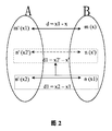
反復オフセット推定アルゴリズムを簡潔に説明するために、最初に留意されるのは、モバイルデバイス内の任意の測位技術により使用される座標系Bがジオフェンスにより使用される座標系Aに変換される変換モデル(略してB−A変換モデルと称される)がモバイルデバイスに格納されることである。図2を参照すると、図2は、本発明によるジオフェンシングを実施するための方法における反復オフセット推定アルゴリズムの使用の概略図である。 To briefly describe the iterative offset estimation algorithm, the first thing to note is the transformation in which the coordinate system B used by any positioning technique in the mobile device is converted to the coordinate system A used by the geofence. A model (referred to as a B-A conversion model for short) is stored in a mobile device. Referring to FIG. 2, FIG. 2 is a schematic diagram of the use of an iterative offset estimation algorithm in a method for performing geofencing according to the present invention.
目標位置における第1座標は、1次元空間における座標であるとする。1次元座標系A(すなわち、第1の座標系)における目標位置の座標は、x1(すなわち、第1座標)であり、x1に対応する1次元座標系B(すなわち、第2の座標系)における座標値x(すなわち、第2座標)が求められることが知られている。反復オフセット推定アルゴリズムは、以下で詳細に説明される。 The first coordinates at the target position are assumed to be coordinates in a one-dimensional space. The coordinates of the target position in the one-dimensional coordinate system A (ie, the first coordinate system) is x1 (ie, the first coordinate), and the one-dimensional coordinate system B (ie, the second coordinate system) corresponding to x1. It is known that the coordinate value x at (i.e., the second coordinate) is obtained. The iterative offset estimation algorithm is described in detail below.
ステップa:第1座標x1と第2座標xとの間のオフセット値を推定する。座標変換に関して、以下の2つの合理的な仮定がある。1:座標系Bにおける任意の2つの隣接点(点1及び点2として参照される)に対し、2つの点を、座標系Aに別々に写像して、2つの写像点(点1'及び点2'として参照される)を取得し、点1'と点1との間のオフセットは、点2'と点2との間のオフセットに近似する。2:座標系Aにおける1点の座標値aは、座標系Bにおける点の座標値bに距離的に近い。
Step a: An offset value between the first coordinate x1 and the second coordinate x is estimated. There are two reasonable assumptions regarding coordinate transformation: 1: For any two neighboring points in coordinate system B (referred to as
図2に示されているように、座標系Bにおける点mの座標値は、xであり、座標系Aに写像された点m'の座標値はx1である。座標系Bにおける点nの座標値は、x1であり、座標系Aに写像された点n'の座標値は、x2であり、x2は、B−A変換モデルに従って計算された座標系Bにおけるx1を、座標系Aに写像したときに得られる座標値である。 As shown in FIG. 2, the coordinate value of the point m in the coordinate system B is x, and the coordinate value of the point m ′ mapped to the coordinate system A is x1. The coordinate value of the point n in the coordinate system B is x1, the coordinate value of the point n ′ mapped to the coordinate system A is x2, and x2 is in the coordinate system B calculated according to the BA conversion model. This is a coordinate value obtained when x1 is mapped to the coordinate system A.
前述の第2の合理的な仮定によれば、xとx1は距離的に近い。したがって、座標系Bにおける点mと点nは隣接している。さらに、前述の第1の合理的な仮定によれば、点m'と点mの間のオフセットdは、点n'と点nとの間のオフセットd1に近く、ここで、d=x1−x、d1=x2−x1、すなわちd≒d1である。 According to the second reasonable assumption described above, x and x1 are close in distance. Therefore, the point m and the point n in the coordinate system B are adjacent. Furthermore, according to the first reasonable assumption described above, the offset d between points m ′ and m is close to the offset d1 between points n ′ and n, where d = x1− x, d1 = x2-x1, that is, d≈d1.
ステップb:xの推定値x'を計算する。d≒d1、x1−x≒x2−x1であるため、x≒x1−(x2−x1)であり、すなわちx'=x1−(x2−x1)である。 Step b: Calculate an estimated value x ′ of x. Since d≈d1 and x1−x≈x2−x1, x≈x1− (x2−x1), that is, x ′ = x1− (x2−x1).
ステップc:反復動作を実行する。図2に示されているように、x'は、x1よりも実際のxに近いため、座標系Bにおける点nの座標値は、x'に置き換えられる。座標系Bにおける座標値がx'である点の座標系Aにおける写像点の座標値はx2'であることが、B−A変換モデルに従って計算され、すなわち、座標系Aにおける点n'の座標値は、x2'と置き換えられる。したがって、新しいオフセット値d1=x2'−x'は、古いd1=x2−x1よりもオフセット値dに近い。したがって、x2'−x'≒x1−xである。したがって、x≒x1−(x2'−x')、すなわち、xの新しい推定値x''=x1−(x2'−x')。 Step c: Repeat operation is performed. As shown in FIG. 2, since x ′ is closer to the actual x than x1, the coordinate value of the point n in the coordinate system B is replaced with x ′. It is calculated according to the BA conversion model that the coordinate value of the mapping point in the coordinate system A of the point whose coordinate value in the coordinate system B is x ′ is x2 ′, that is, the coordinate of the point n ′ in the coordinate system A. The value is replaced with x2 ′. Therefore, the new offset value d1 = x2′−x ′ is closer to the offset value d than the old d1 = x2−x1. Therefore, x2′−x′≈x1−x. Therefore, x≈x1− (x2′−x ′), that is, a new estimate x ″ of x ″ = x1− (x2′−x ′).
同様に、x''は、x'よりも実際のxに近い。したがって、点nの座標値は、x''に置き換えられる。ステップcは、x1と、点nの置き換えられた座標値が座標系Aに写像されたときに得られた座標値との間の差の絶対値がプリセット値より小さくなるまで、すなわち、座標系Aにおいて直近に得られた点n'と点m'との間の距離がプリセット値より小さくなるまで繰り返され、その後実際のxに近い推定値が取得される。プリセット値は、必要に応じてモバイルデバイスにより設定され、例えば、遅延や計算の複雑さなどの要件に応じて設定される。 Similarly, x ″ is closer to the actual x than x ′. Therefore, the coordinate value of the point n is replaced with x ″. Step c is performed until the absolute value of the difference between x1 and the coordinate value obtained when the replaced coordinate value of the point n is mapped to the coordinate system A is smaller than the preset value, that is, the coordinate system It repeats until the distance between the point n ′ and the point m ′ obtained most recently in A becomes smaller than the preset value, and then an estimated value close to the actual x is obtained. The preset value is set by the mobile device as necessary, and is set according to requirements such as delay and calculation complexity, for example.
2次元座標及び3次元座標に関しては、各次元の変換原理は、1次元座標の変換と同じであり、2次元座標及び3次元座標は、前述のステップを拡張することで取得され得る。詳細な処理はここでは詳細に説明しない。 Regarding the two-dimensional coordinates and the three-dimensional coordinates, the conversion principle of each dimension is the same as the conversion of the one-dimensional coordinates, and the two-dimensional coordinates and the three-dimensional coordinates can be obtained by extending the above-described steps. Detailed processing is not described in detail here.
同様に、ジオフェンスの第1座標が複数の座標のセットである場合、第1座標における各座標に対して前述の反復オフセット推定方法が用いられる限り、第2の座標系に変換された各座標の座標は、計算され得る。したがって、第2の座標系における計算された座標のセットは、第2の座標系におけるジオフェンスを表す第2座標である。 Similarly, when the first coordinate of the geofence is a set of a plurality of coordinates, each coordinate converted into the second coordinate system is used as long as the above-described iterative offset estimation method is used for each coordinate in the first coordinate. The coordinates of can be calculated. Thus, the calculated set of coordinates in the second coordinate system is the second coordinates representing the geofence in the second coordinate system.
この実施形態において、ジオフェンスの第1座標を、反復オフセット推定アルゴリズムを使用して、第2座標に変換することは、異なる座標系を変換するための要件を満たすことができ、異なる座標系を使用するジオフェンシングに適用でき、より広い適用範囲を有する。 In this embodiment, converting the first coordinate of the geofence to the second coordinate using an iterative offset estimation algorithm can satisfy the requirements for converting different coordinate systems, It can be applied to the geofencing used and has a wider application range.
理解の便宜のために、本発明のこの実施形態におけるジオフェンシングを実施するための方法が、実際の適用シナリオを用いて以下に説明される。 For convenience of understanding, the method for performing geofencing in this embodiment of the present invention is described below using an actual application scenario.
この実施形態において、モバイルデバイスは携帯電話である。ジオフェンスが設定されている場合、携帯電話のタッチスクリーンには、地図が表示され、地図により使用される座標系は、BD09である。ユーザは、タッチスクリーン上をスライドすることにより地図上の地理的領域を手動で囲む。携帯電話は、地理的領域の端にある点の座標値を取得し、点の座標値をジオフェンスに設定する。したがって、ジオフェンスにより使用される座標系は、BD09である。携帯電話が、ジオフェンスが設定されていることを検出した場合、座標系BD09におけるジオフェンスを表す第1座標が決定される。 In this embodiment, the mobile device is a mobile phone. When the geofence is set, a map is displayed on the touch screen of the mobile phone, and the coordinate system used by the map is BD09. The user manually surrounds the geographic area on the map by sliding on the touch screen. The mobile phone acquires the coordinate value of the point at the end of the geographical area, and sets the coordinate value of the point in the geofence. Therefore, the coordinate system used by the geofence is BD09. When the mobile phone detects that the geofence is set, the first coordinate representing the geofence in the coordinate system BD09 is determined.
ジオフェンシングを実施するために設定され、測位技術により使用される、携帯電話にプリセットされている座標系は、GLONASSシステム(英語では略してGLONASS)であり、GLONASSにより使用される座標系は、PE-90である。座標系PE-90を座標系BD09に変換するために必要な変換モデルは、携帯電話に予め格納されている。 The mobile phone preset coordinate system that is set to perform geofencing and used by positioning technology is the GLONASS system (GLONASS for short in English), and the coordinate system used by GLONASS is PE -90. A conversion model necessary for converting the coordinate system PE-90 to the coordinate system BD09 is stored in advance in the mobile phone.
携帯電話は、第1座標における各座標値を、反復オフセット推定アルゴリズムを使用して、座標系PE-90におけるジオフェンスを表す第2座標に変換する。 The mobile phone converts each coordinate value in the first coordinate to a second coordinate representing a geofence in the coordinate system PE-90 using an iterative offset estimation algorithm.
第2座標が計算された後、携帯電話は、指定された測位技術に従ってGLONASS測位機能を有効にし、携帯電話の位置を決定する。測位頻度は、携帯電話にプリセットされている。測位結果の座標は、測位機能を有効にしたのち、間隔を置いて取得され、測位結果の座標が、第2座標と比較される。 After the second coordinates are calculated, the mobile phone activates the GLONASS positioning function according to the specified positioning technology and determines the position of the mobile phone. The positioning frequency is preset in the mobile phone. The coordinates of the positioning result are acquired at intervals after enabling the positioning function, and the coordinates of the positioning result are compared with the second coordinates.
測位結果の座標がジオフェンスの外側に位置し、ジオフェンスへの最小距離が5メートル以下であると判定された場合、携帯電話は、携帯電話が領域にまさに入ろうとしていることを示すリマインダを送信する。リアルタイムの測位結果がジオフェンスの内側に位置すると判定された場合、携帯電話は、領域のソーシャルネットワークに自動的にログインし、その領域に関する広告情報をプッシュする。リアルタイム測位結果がジオフェンスの外側に位置し、ジオフェンスへの距離が5メートルより大きいと判定された場合、携帯電話は、その領域のソーシャルネットワークから自動的に抜ける。 If the coordinates of the positioning result are located outside the geofence and the minimum distance to the geofence is determined to be less than 5 meters, the cell phone sends a reminder indicating that the cell phone is about to enter the area To do. If it is determined that the real-time positioning result is located inside the geofence, the mobile phone automatically logs into the social network of the area and pushes advertisement information regarding the area. If the real-time positioning result is located outside the geofence and it is determined that the distance to the geofence is greater than 5 meters, the mobile phone automatically exits the social network in that area.
以上、本発明の実施形態におけるジオフェンシングを実施するための方法について説明したが、本発明の実施形態におけるモバイルデバイスについて以下に説明する。図3を参照すると、本発明のこの実施形態におけるモバイルデバイス300は、
ジオフェンスが設定されているかどうかを検出するように構成されている検出モジュール301と、
検出モジュールが、ジオフェンスが設定されていることを検出した場合に、第1の座標系におけるジオフェンスを表す第1座標を決定するように構成されている決定モジュールであって、第1の座標系は、ジオフェンスにより使用される座標系である、決定モジュール302と、
決定モジュールにより決定された第1座標を、第2の座標系におけるジオフェンスを表す第2座標に変換するように構成されている変換モジュールであって、第2の座標系は、ジオフェンシングを実施するように設定され、測位技術により使用される座標系であり、第1の座標系は、第2の座標系とは異なる、変換モジュール303と、
測位技術を使用してモバイルデバイスの測位結果を決定する測位モジュール304と、
測位モジュールにより測定された測位結果の座標を、ジオフェンスを表す第2座標と比較するように構成された比較モジュール305と、
測位モジュールにより測定された測位結果の座標とジオフェンスを表す第2座標との間の関係が、トリガ条件を満たす場合、プリセットイベントをトリガするように構成されたトリガモジュール306と、
を含む。
The method for performing geofencing in the embodiment of the present invention has been described above. The mobile device in the embodiment of the present invention will be described below. Referring to FIG. 3, the
A
A determination module configured to determine a first coordinate representing a geofence in a first coordinate system when the detection module detects that a geofence is set, the first coordinate The system is a
A transformation module configured to transform a first coordinate determined by a determination module into a second coordinate representing a geofence in a second coordinate system, the second coordinate system performing geofencing A coordinate system that is set to be used by the positioning technique, the first coordinate system being different from the second coordinate system,
A
A
A
including.
この実施形態において、測位技術を用いて測定された測位結果が得られる前に、ジオフェンスにより使用される第1の座標系におけるジオフェンスの第1座標が、測位技術により使用される第2の座標系におけるジオフェンスを表す第2座標にまず変換されるため、この方法により、各測位結果がその後ジオフェンスと比較される場合、測位結果は、ジオフェンスにより使用される座標系における測位結果に変換される必要が無い。座標変換は、プロセス全体で一度だけ実行される。座標変換が各測位結果に対して一度実行される必要がある背景技術と比べ、本発明は、ジオフェンシングの消費電力を低減するように、ジオフェンシング動作の複雑さをかなり低減でき、ジオフェンスと測位結果の異なる座標系に起因する位置偏差の問題を解決することができる。 In this embodiment, before the positioning result measured using the positioning technique is obtained, the first coordinate of the geofence in the first coordinate system used by the geofence is the second used by the positioning technique. Because this method is first transformed into a second coordinate that represents the geofence in the coordinate system, when each positioning result is subsequently compared to the geofence, the positioning result is converted to the positioning result in the coordinate system used by the geofence. There is no need to be converted. The coordinate transformation is performed only once during the entire process. Compared to background technology where coordinate transformation needs to be performed once for each positioning result, the present invention can significantly reduce the complexity of the geofencing operation, reducing the power consumption of geofencing, It is possible to solve the problem of position deviation caused by coordinate systems with different positioning results.
オプションとして、変換モジュールは、第1座標を、反復オフセット推定アルゴリズムを使用して、第2の座標系におけるジオフェンスを表す第2座標に変換するように特に構成されている。 Optionally, the transform module is specifically configured to transform the first coordinate to a second coordinate that represents a geofence in the second coordinate system using an iterative offset estimation algorithm.
オプションとして、変換モジュールは、第1座標を、プリセットされた変換モデルに従って、第2の座標系におけるジオフェンスを表す第2座標に変換する
ように特に構成されている。
Optionally, the conversion module is specifically configured to convert the first coordinate to a second coordinate representing a geofence in the second coordinate system according to a preset conversion model.
好適には、モバイルデバイスは、APと、APよりも消費電力の低い、APとは独立した低消費電力プロセッサ若しくは低消費電力SoCとを含み、比較モジュールは、低消費電力プロセッサ又は低消費電力SoCにおいて特に実装される。 Preferably, the mobile device includes an AP and a low power consumption processor or low power consumption SoC independent of the AP, which consumes less power than the AP, and the comparison module is a low power consumption processor or low power consumption SoC. In particular.
理解の便宜のため、本発明のこの実施形態におけるモバイルデバイスは、実際の適用シナリオを使用して以下に説明される。 For convenience of understanding, the mobile device in this embodiment of the invention is described below using an actual application scenario.
図4を参照すると、図4は、本発明によるモバイルデバイスの別の実施形態の概略構成図である。この実施形態において、モバイルデバイス400は、アプリケーションモジュール401、ジオフェンシング・エンジンモジュール402、及びジオフェンシング・監視モジュール403を含む。アプリケーションモジュール401とジオフェンシング・監視モジュール403は、ジオフェンシング・エンジンモジュール402との接続を別々に確立し、ジオフェンシング・エンジンモジュール402を使用して通信を実行する。
Referring to FIG. 4, FIG. 4 is a schematic structural diagram of another embodiment of a mobile device according to the present invention. In this embodiment, the
アプリケーションモジュール401は、ジオフェンシング・アプリケーションユニット4011を含む。ジオフェンシング・アプリケーションユニット4011は、ジオフェンシングを実施するために使用されるジオフェンスと、測位技術とを設定し、ジオフェンスのトリガ条件が満たされた場合に実行されるプリセットイベントを設定し、トリガ条件が満たされた場合にはプリセットイベントを実行するように特に構成されている。
The
好適には、ジオフェンシング・アプリケーションユニット4011は、ジオフェンスが設定されていることが検出された場合に、第1の座標系におけるジオフェンスを表す第1座標を決定するように構成され、第1の座標系は、ジオフェンスにより使用される座標系である。
Preferably, the
オプションとして、ジオフェンシング・アプリケーションユニット4011は、ジオフェンスを編集、削除、起動、または無効にするようにさらに構成されてもよい。あるいは、ジオフェンシング・アプリケーションユニット4011は、測位動作モードをさらに設定してもよい。測位動作モードは、2種類を含み得、1つのタイプはただ1つだけの測位技術を使用して測位を実行するものであり、他のタイプは、少なくとも2つの位置技術を使用して測位を実行するものである。あるいは、ジオフェンシング・アプリケーションユニット4011が少なくとも2つのジオフェンスを設定する場合、ジオフェンシング・アプリケーションユニット4011は、ジオフェンスに対応するトリガイベントの優先順位を設定するようにさらに構成されるので、少なくとも2つのジオフェンスのトリガ条件を同時に満たす場合、ジオフェンシング・アプリケーションユニット4011は、ジオフェンスに対応するプリセットイベントを優先順位に従って実行することができる。
Optionally, the
好適には、アプリケーションモジュール401は、別の位置情報サービス(英語:Location Based Service, 略してLBS)アプリケーションユニット4012をさらに含んでもよい。別のLBSアプリケーションユニット4012は、ジオフェンシング・アプリケーションユニット4011に仮想フェンスセットを提供し得る。ジオフェンスを設定する場合、ジオフェンシング・アプリケーションユニット4011は、別のLBSアプリケーションユニット4012における仮想フェンスをジオフェンスとしてロードし得る。あるいは、別のLBSアプリケーションユニット4012は、ジオフェンスのトリガ条件が満たされる場合にトリガされるプリセットイベントをプリセットし、ジオフェンスのトリガ条件が満たされる場合に、プリセットイベントをトリガしてもよい。
Preferably, the
ジオフェンシング・エンジンモジュール402は、座標変換ユニット4021とジオフェンシング・管理ユニット4022とを含む。
The geo-
座標変換ユニット4021は、決定された第1座標を第2の座標系におけるジオフェンスを表す第2座標に変換するように構成され、第2の座標系は、ジオフェンシングを実施するように設定され、測位技術により使用される座標系であり、第1の座標系は、第2の座標系とは異なる。
The coordinate
ジオフェンシング・管理ユニット4022は、ジオフェンシング・アプリケーションユニット4011により設定され、ジオフェンシングを実施するために使用される測位技術に従って測位ユニット4031を開始するように構成されている(以下の説明を参照)。測位動作モードがジオフェンシング・アプリケーションユニット4011においてさらに設定されている場合、ジオフェンシング・管理ユニット4022は、ジオフェンシング・アプリケーションユニット4011により設定された測位動作モードに従って測位ユニット4031を開始するようにさらに構成されている。
The geofencing and
ジオフェンシング・監視モジュール403は、測位ユニット4031と位置監視ユニット4032とを含む。測位ユニット4031は、ジオフェンシング・アプリケーションユニット4011により設定された測位技術に従ってモバイルデバイスの測位結果を決定し、測位結果を位置監視ユニット4032にさらに送信するように構成されている。
The geofencing /
位置監視ユニット4032は、測位ユニット4031から受信した測位結果を、座標変換ユニット4021から受信した第2座標と比較し、測位結果とジオフェンスとの間でトリガ条件が満たされているかどうかを判定し、測位結果とジオフェンスとの間でトリガ条件が満たされる場合、ジオフェンスステータス変更通知をジオフェンシング・管理ユニット4022に送信し、ジオフェンシング・管理ユニット4022がアプリケーションモジュール401をトリガし、プリセットイベントを実行する。
The
好適には、位置監視ユニット4032は、APとは独立した低消費電力プロセッサに設定されるか、又はAPとは独立した低消費電力SoCに統合され、ジオフェンシングの稼働消費電力を低減するように、APの呼び出し頻度を低下させる。
Preferably, the
以上、本発明のこの実施形態におけるモバイルデバイスは、機能エンティティのユニット化の観点から説明したが、以下では、本発明の実施形態におけるモバイルデバイスについて、ハードウェア処理の観点から説明される。図5を参照すると、図5は、本発明によるモバイルデバイスのさらに他の実施形態の概略構成図である。この実施形態において、モバイルデバイス500は、メモリ501とプロセッサ502とを含む。メモリ501とプロセッサ502は、バス503を使用して接続されている。
Although the mobile device in this embodiment of the present invention has been described from the viewpoint of unitization of functional entities, the mobile device in the embodiment of the present invention will be described below from the viewpoint of hardware processing. Referring to FIG. 5, FIG. 5 is a schematic structural diagram of still another embodiment of a mobile device according to the present invention. In this embodiment,
メモリ501は、プログラムコードの1つのグループを格納し、プロセッサ502は、メモリ501に格納されたプログラムコードを呼び出し、以下の動作:
ジオフェンスが設定されていることが検出された場合、第1の座標系におけるジオフェンスを表す第1座標を決定することであって、第1の座標系は、ジオフェンスにより使用される座標系である、決定することと、
第1座標を、第2の座標系におけるジオフェンスを表す第2座標に変換することであって、第2の座標系は、ジオフェンシングを実施するように設定され、測位技術により使用される座標系であり、第1の座標系は、第2の座標系とは異なる、変換することと、
測位技術を使用して測定された測位結果の座標を、ジオフェンスを表す第2座標と比較することと、
測位結果の座標とジオフェンスを表す第2座標との間の関係が、トリガ条件を満たす場合、プリセットイベントをトリガすることと、
を実行するように構成されている。
The
If it is detected that a geofence is set, determining a first coordinate representing the geofence in the first coordinate system, the first coordinate system being a coordinate system used by the geofence Is to decide,
Converting the first coordinate to a second coordinate representing a geofence in a second coordinate system, wherein the second coordinate system is set to perform geofencing and is used by a positioning technique The first coordinate system is different from the second coordinate system,
Comparing the coordinates of the positioning results measured using the positioning technique with the second coordinates representing the geofence;
Triggering a preset event if the relationship between the coordinates of the positioning result and the second coordinate representing the geofence satisfies the trigger condition;
Is configured to run.
好適には、プロセッサ502は、
第1座標を、反復オフセット推定アルゴリズムを使用して、第2の座標系におけるジオフェンスを表す第2座標に変換する
ようにさらに構成されている。
Preferably, the
The first coordinate is further configured to convert to a second coordinate that represents a geofence in the second coordinate system using an iterative offset estimation algorithm.
好適には、プロセッサ502は、
第1座標を、プリセットされた変換モデルに従って、第2の座標系におけるジオフェンスを表す第2座標に変換する
ようにさらに構成されている。
Preferably, the
The first coordinate is further configured to convert to a second coordinate representing a geofence in the second coordinate system according to a preset conversion model.
当業者であれば、簡潔かつ簡単な説明のために、前述のシステム、装置、及びユニットの詳細な動作処理については、前述の方法の実施形態における対応する処理を参照して明確に理解し得、詳細はここでは再び説明しない。 For those skilled in the art, for the sake of concise and simple explanation, the detailed operational processing of the aforementioned systems, devices and units can be clearly understood with reference to the corresponding processing in the foregoing method embodiments. Details are not described here again.
さらに、本発明の実施形態は、実行された場合に以下の動作を実行するコンピュータ可読命令を含むコンピュータ可読媒体をさらに提供する:前述の実施形態におけるステップ101から104を実行することであって、ここでは再び説明しない。 In addition, embodiments of the present invention further provide a computer readable medium comprising computer readable instructions that, when executed, perform the following operations: performing steps 101-104 in the foregoing embodiments, I will not explain it again here.
さらに、実施形態は、前述のコンピュータ可読媒体を含むコンピュータプログラム製品をさらに提供する。 Furthermore, the embodiments further provide a computer program product comprising the aforementioned computer-readable medium.
この明細書において提供されるいくつかの実施形態において、開示されたシステム、装置、及び方法は、他の様式で実装され得ることは理解すべきである。例えば、説明された装置の実施形態は、単なる例示にすぎない。例えば、ユニット分割は、単に論理的な機能分割であり、実際の実装において他の分割であっても良い。例えば、複数のユニット又は構成要素は、別のシステムに組み合わせ又は統合してもよいし、又は、一部の特徴は、無視してもよいし、又は実行しなくてもよい。さらに、表示され又は議論された相互結合若しくは直接結合又は通信接続は、いくつかのインターフェースを使用して実装され得る。装置あんたはユニット間の間接的結合又は通信接続は、電子的、機械的、又は他の形状で実装されてもよい。 It should be understood that in some embodiments provided in this specification, the disclosed systems, devices, and methods may be implemented in other manners. For example, the described apparatus embodiment is merely exemplary. For example, the unit division is merely logical function division, and may be other division in actual implementation. For example, multiple units or components may be combined or integrated into another system, or some features may be ignored or not performed. Further, the displayed or discussed mutual coupling or direct coupling or communication connection may be implemented using several interfaces. Indirect coupling or communication connections between devices or units may be implemented electronically, mechanically, or in other forms.
別個の部品として説明されたユニットは、物理的に分離していてもいなくてもよく、ユニットとして表示されている部品は、物理的ユニットであってもなくてもよく、1カ所に配置されてもよいし、又は複数のネットワークユニット上に分散されてもよい。ユニットの一部又は全部は、実施形態の解決策の目的を達成するために、実際の必要に応じて選択されてよい。 Units described as separate parts may or may not be physically separated, and parts displayed as units may or may not be physical units and are located in one place. It may be distributed over a plurality of network units. Some or all of the units may be selected according to actual needs to achieve the objectives of the solutions of the embodiments.
また、本発明の実施形態における機能ユニットは、1つの処理ユニットに統合されてもよいし、又は物理的に単独で存在してもよく、又は、2つ以上のユニットが1つのユニットに統合されてもよい。統合ユニットは、ハードウェアの形態で実装されても、ソフトウェア機能ユニットの形態で実装されてもよい。 In addition, the functional units in the embodiments of the present invention may be integrated into one processing unit or may physically exist alone, or two or more units may be integrated into one unit. May be. The integrated unit may be implemented in the form of hardware or in the form of a software functional unit.
統合ユニットがソフトウェア機能ユニットの形態で実装され、独立した製品として販売又は使用される場合には、統合ユニットは、コンピュータ可読記憶媒体に格納されてもよい。そのような理解に基づいて、本質的に本発明の技術的解決策、又は先行技術に寄与する部分、又は技術的解決策のすべてまたはいくつかは、ソフトウェア製品の形態で実施されてもよい。ソフトウェア製品は、記憶媒体に格納され、コンピュータデバイス(パーソナルコンピュータ、サーバ、又はネットワークデバイスであり得る)に、本発明の実施形態に説明されている方法のステップの全部または一部を実行するように指示するためのいくつかの命令を含む。上記記憶媒体は、USBフラッシュドライブ、リムーバブル・ハードディスク、読み出し専用メモリ(ROM, Read-Only Memory)、ランダムアクセスメモリ(RAM, Random Access Memory)、磁気ディスク、又は光学ディスクなどのプログラムコードを格納することができる任意の媒体を含む。 If the integrated unit is implemented in the form of a software functional unit and sold or used as an independent product, the integrated unit may be stored on a computer-readable storage medium. Based on such understanding, all or some of the technical solutions of the present invention, or portions that contribute to the prior art, or technical solutions may be implemented in the form of a software product. The software product is stored in a storage medium so that a computer device (which may be a personal computer, server, or network device) performs all or part of the method steps described in the embodiments of the present invention. Includes some instructions to direct. The storage medium stores a program code such as a USB flash drive, a removable hard disk, a read-only memory (ROM), a random access memory (RAM), a magnetic disk, or an optical disk. Including any medium capable of
前述の実施形態は、本発明の技術的解決策を説明するためのものであって、本発明を限定するものではない。本発明は、前述の実施形態を参照して詳細に説明されているが、当業者であれば、本発明の実施形態の技術的解決策の精神及び範囲から逸脱することなく、前述の実施形態で説明した技術的解決策を変更したり、その技術的特徴の一部を等価に置き換えたりできることは理解すべきである。 The above-described embodiments are for explaining the technical solutions of the present invention, and do not limit the present invention. Although the present invention has been described in detail with reference to the above-described embodiments, those skilled in the art will recognize the above-described embodiments without departing from the spirit and scope of the technical solutions of the embodiments of the present invention. It should be understood that the technical solution described in can be altered or that some of its technical features can be replaced equivalently.
301 検出モジュール
302 決定モジュール
303 変換モジュール
304 測位モジュール
305 比較モジュール
306 トリガモジュール
401 アプリケーションモジュール
4011 ジオフェンシング・アプリケーションユニット
4012 他のLBSアプリケーションユニット
402 ジオフェンシング・エンジンモジュール
4021 座標変換ユニット
4022 ジオフェンシング・管理ユニット
403 ジオフェンシング・監視モジュール
4031 測位ユニット
4032 位置監視ユニット
501 メモリ
502 プロセッサ
301
Claims (3)
ジオフェンスが設定されていることが検出された場合、モバイルデバイスのプロセッサにより、第1の座標系における前記ジオフェンスを表す第1座標を決定するステップであって、前記第1の座標系は、前記ジオフェンスにより使用される座標系である、ステップと、
前記モバイルデバイスの前記プロセッサにより、前記第1座標を、第2の座標系における前記ジオフェンスを表す第2座標に変換するステップであって、前記第2の座標系は、ジオフェンシングを実施するように設定され、測位技術により使用される座標系であり、前記第1の座標系は、前記第2の座標系とは異なる、ステップと、
前記モバイルデバイスの前記プロセッサにより、前記測位技術を使用して測定された測位結果の座標を、前記ジオフェンスを表す前記第2座標と比較するステップと、
前記測位結果の座標と前記ジオフェンスを表す前記第2座標との間の関係が、トリガ条件を満たす場合、前記モバイルデバイスの前記プロセッサにより、プリセットイベントをトリガするステップと、
を具備し、
前記モバイルデバイスの前記プロセッサにより、前記第1座標を、第2の座標系における前記ジオフェンスを表す第2座標に変換する前記ステップは、
前記第1座標を、反復オフセット推定アルゴリズムを使用して、前記第2の座標系における前記ジオフェンスを表す前記第2座標に変換するステップ
を具備することを特徴とするジオフェンシングを実施するための方法。 A method for performing geofencing, comprising:
If it is detected that a geofence is set, the mobile device processor determines first coordinates representing the geofence in a first coordinate system, the first coordinate system comprising: A coordinate system used by the geofence, and
Converting the first coordinate to a second coordinate representing the geofence in a second coordinate system by the processor of the mobile device , wherein the second coordinate system performs geofencing. A coordinate system used by the positioning technique, wherein the first coordinate system is different from the second coordinate system;
Comparing coordinates of positioning results measured by the processor of the mobile device using the positioning technique with the second coordinates representing the geofence;
Triggering a preset event by the processor of the mobile device if a relationship between the coordinates of the positioning result and the second coordinate representing the geofence satisfies a trigger condition;
Equipped with,
The step of converting the first coordinate by the processor of the mobile device into a second coordinate representing the geofence in a second coordinate system comprises:
Transforming the first coordinates into the second coordinates representing the geofence in the second coordinate system using an iterative offset estimation algorithm. Method for carrying out.
ジオフェンスが設定されていることが検出された場合、第1の座標系における前記ジオフェンスを表す第1座標を決定することであって、前記第1の座標系は、前記ジオフェンスにより使用される座標系である、決定することと、
前記第1座標を、第2の座標系における前記ジオフェンスを表す第2座標に変換することであって、前記第2の座標系は、ジオフェンシングを実施するように設定され、測位技術により使用される座標系であり、前記第1の座標系は、前記第2の座標系とは異なる、変換することと、
前記測位技術を使用して測定された測位結果の座標を、前記ジオフェンスを表す前記第2座標と比較することと、
前記測位結果の座標と前記ジオフェンスを表す前記第2座標との間の関係が、トリガ条件を満たす場合、プリセットイベントをトリガすることと、
を実行するように構成されており、
前記プロセッサは、
前記第1座標を、反復オフセット推定アルゴリズムを使用して、前記第2の座標系における前記ジオフェンスを表す前記第2座標に変換する
ようにさらに構成されていることを特徴とするモバイルデバイス。 A mobile device comprising a memory and a processor, wherein the memory stores one group of program codes, the processor calls the program codes stored in the memory, and performs the following operations:
Determining that a geofence is set, determining a first coordinate representing the geofence in a first coordinate system, wherein the first coordinate system is used by the geofence; Determining the coordinate system,
Converting the first coordinate to a second coordinate representing the geofence in a second coordinate system, wherein the second coordinate system is set to perform geofencing and used by a positioning technique A coordinate system, wherein the first coordinate system is different from the second coordinate system,
Comparing coordinates of positioning results measured using the positioning technique with the second coordinates representing the geofence;
Triggering a preset event if a relationship between the coordinates of the positioning result and the second coordinates representing the geofence satisfies a trigger condition;
It is configured to perform a,
The processor is
Convert the first coordinate to the second coordinate representing the geofence in the second coordinate system using an iterative offset estimation algorithm
A mobile device characterized in that it is further configured .
ジオフェンスが設定されていることが検出された場合、第1の座標系において前記ジオフェンスを表す第1座標を決定するステップであって、前記第1の座標系は、前記ジオフェンスにより使用される座標系である、ステップと、
前記第1座標を、第2の座標系における前記ジオフェンスを表す第2座標に変換するステップであって、前記第2の座標系は、ジオフェンシングを実施するように設定され、測位技術により使用される座標系であり、前記第1の座標系は、前記第2の座標系とは異なる、ステップと、
前記測位技術を使用して測定された測位結果の座標を、前記ジオフェンスを表す前記第2座標と比較するステップと、
前記測位結果の座標と前記ジオフェンスを表す前記第2座標との間の関係が、トリガ条件を満たす場合、プリセットイベントをトリガするステップと、
を実施させ、
前記第1座標を、第2の座標系における前記ジオフェンスを表す第2座標に変換する前記ステップは、
前記第1座標を、反復オフセット推定アルゴリズムを使用して、前記第2の座標系における前記ジオフェンスを表す前記第2座標に変換するステップ
を具備することを特徴とする非一時的なコンピュータ可読記憶媒体。 A non-transitory computer readable storage medium comprising computer readable instructions, wherein when the computer readable instructions are executed by a computer processor, the computer processor performs the following operations:
If it is detected that a geofence is set, determining a first coordinate representing the geofence in a first coordinate system, wherein the first coordinate system is used by the geofence. A coordinate system, step,
Converting the first coordinate to a second coordinate representing the geofence in a second coordinate system, wherein the second coordinate system is set to perform geofencing and used by a positioning technique A coordinate system, wherein the first coordinate system is different from the second coordinate system;
Comparing the coordinates of the positioning results measured using the positioning technique with the second coordinates representing the geofence;
Triggering a preset event if a relationship between the coordinates of the positioning result and the second coordinates representing the geofence satisfies a trigger condition;
It was carried out,
The step of converting the first coordinate to a second coordinate representing the geofence in a second coordinate system;
Converting the first coordinate to the second coordinate representing the geofence in the second coordinate system using an iterative offset estimation algorithm;
Non-transitory computer-readable storage medium characterized that you include a.
Applications Claiming Priority (1)
| Application Number | Priority Date | Filing Date | Title |
|---|---|---|---|
| PCT/CN2014/094044 WO2016095120A1 (en) | 2014-12-17 | 2014-12-17 | Geo-fencing implementation method and mobile device |
Publications (2)
| Publication Number | Publication Date |
|---|---|
| JP2018510521A JP2018510521A (en) | 2018-04-12 |
| JP6474011B2 true JP6474011B2 (en) | 2019-02-27 |
Family
ID=56125584
Family Applications (1)
| Application Number | Title | Priority Date | Filing Date |
|---|---|---|---|
| JP2017532894A Active JP6474011B2 (en) | 2014-12-17 | 2014-12-17 | Method and mobile device for performing geofencing |
Country Status (6)
| Country | Link |
|---|---|
| US (1) | US9900741B2 (en) |
| EP (1) | EP3226587B1 (en) |
| JP (1) | JP6474011B2 (en) |
| KR (1) | KR101953500B1 (en) |
| CN (1) | CN106465054B (en) |
| WO (1) | WO2016095120A1 (en) |
Families Citing this family (12)
| Publication number | Priority date | Publication date | Assignee | Title |
|---|---|---|---|---|
| WO2017184000A1 (en) * | 2016-04-20 | 2017-10-26 | Motorola Solutions, Inc. | Geofence parameters based on type of touch on a touch screen |
| CN108829840B (en) * | 2018-06-19 | 2021-01-15 | 品信科技有限公司 | Electronic fence map construction method and device |
| KR20200110050A (en) * | 2019-03-15 | 2020-09-23 | 삼성전자주식회사 | Electronic device and method for dynaminc geofencing in the electronic device |
| EP3920558A4 (en) * | 2019-03-25 | 2022-02-16 | Huawei Technologies Co., Ltd. | Method for determining that terminal device is located inside geofence, and terminal device |
| EP3734318A1 (en) * | 2019-04-29 | 2020-11-04 | HERE Global B.V. | Geofence prioritization |
| CN113124853A (en) * | 2019-12-31 | 2021-07-16 | 广东博智林机器人有限公司 | Positioning translation method and device, navigation method, device, equipment and storage medium |
| US11092682B1 (en) * | 2020-04-30 | 2021-08-17 | Google Llc | Determining arrival and departure latency for WiFi devices in an environment |
| CN112087708B (en) * | 2020-08-14 | 2022-09-16 | 江苏省电力试验研究院有限公司 | Layout method and layout device of electronic fence and storage medium |
| CN112218232B (en) * | 2020-09-02 | 2023-08-18 | 宇龙计算机通信科技(深圳)有限公司 | Method and device for judging entrance and exit of electronic fence, storage medium and electronic equipment |
| US11875335B2 (en) * | 2021-08-10 | 2024-01-16 | Capital One Services, Llc | Determining merchant enforced transaction rules |
| CN113779166B (en) * | 2021-08-20 | 2024-02-13 | 上海瑾盛通信科技有限公司 | Geofence control method and device, storage medium and electronic equipment |
| CN118711350B (en) * | 2024-08-29 | 2024-11-29 | 广东电网有限责任公司东莞供电局 | Monitoring method and device for electric power place, electronic equipment and storage medium |
Family Cites Families (21)
| Publication number | Priority date | Publication date | Assignee | Title |
|---|---|---|---|---|
| JP2001021364A (en) * | 1999-07-02 | 2001-01-26 | Matsushita Electric Ind Co Ltd | Automatic converter for mail affixing positional information coordinate system |
| US7164986B2 (en) * | 2004-01-16 | 2007-01-16 | Mci, Llc | Method and system for tracked device location and route adherence via geofencing |
| US8538393B1 (en) | 2004-09-21 | 2013-09-17 | Advanced Ground Information Systems, Inc. | Method to provide ad hoc and password protected digital and voice networks |
| WO2007069890A1 (en) | 2005-12-12 | 2007-06-21 | Nederlandse Organisatie Voor Toegepast-Natuurwetenschappelijk Onderzoek Tno | System for providing a warning signal when a movable body is present in a predetermined non-allowable zone |
| US7493211B2 (en) * | 2005-12-16 | 2009-02-17 | General Electric Company | System and method for updating geo-fencing information on mobile devices |
| US8031114B2 (en) * | 2008-03-31 | 2011-10-04 | International Business Machines Corporation | Infrastructure and method for geography based vehicle alert |
| US20120172027A1 (en) * | 2011-01-03 | 2012-07-05 | Mani Partheesh | Use of geofences for location-based activation and control of services |
| WO2012122448A1 (en) * | 2011-03-10 | 2012-09-13 | Agco Corporation | Moving geofence for machine tracking in agriculture |
| US9118776B2 (en) * | 2011-06-03 | 2015-08-25 | Apple Inc. | Location monitoring feature of a mobile device for activating an application subsystem |
| US8810454B2 (en) | 2011-10-13 | 2014-08-19 | Microsoft Corporation | Power-aware tiered geofencing and beacon watchlists |
| US8942729B2 (en) | 2012-02-02 | 2015-01-27 | Apple Inc. | Location based methods, systems, and program products for performing an action at a user device |
| CN102761822B (en) | 2012-06-28 | 2016-08-03 | 惠州Tcl移动通信有限公司 | A kind of message method and mobile terminal |
| US8971930B2 (en) * | 2012-12-11 | 2015-03-03 | Blackberry Limited | Geofencing system and method |
| US9589435B2 (en) * | 2012-12-14 | 2017-03-07 | Qualcomm Incorporated | Providing alerts, vouchers, or coupons once a plurality of geo-fences have been breached a number of times |
| US20140337123A1 (en) * | 2013-03-15 | 2014-11-13 | 30 Second Software, Inc. | System and method for adaptive use of geofence parameters |
| US9998866B2 (en) * | 2013-06-14 | 2018-06-12 | Microsoft Technology Licensing, Llc | Detecting geo-fence events using varying confidence levels |
| US8755824B1 (en) * | 2013-06-28 | 2014-06-17 | Google Inc. | Clustering geofence-based alerts for mobile devices |
| US9167381B2 (en) * | 2013-12-19 | 2015-10-20 | Motorola Solutions, Inc. | Geo-fence based alerts |
| US20150237470A1 (en) * | 2014-02-14 | 2015-08-20 | Apple Inc. | Personal Geofence |
| US9078098B1 (en) * | 2014-06-04 | 2015-07-07 | Grandios Technologies, Llc | Geo-fencing based functions |
| US9338598B2 (en) * | 2014-07-09 | 2016-05-10 | Samsung Electronics Co., Ltd | Geo-fence solver |
-
2014
- 2014-12-17 JP JP2017532894A patent/JP6474011B2/en active Active
- 2014-12-17 WO PCT/CN2014/094044 patent/WO2016095120A1/en active Application Filing
- 2014-12-17 US US15/537,653 patent/US9900741B2/en active Active
- 2014-12-17 EP EP14908155.6A patent/EP3226587B1/en active Active
- 2014-12-17 KR KR1020177019020A patent/KR101953500B1/en active IP Right Grant
- 2014-12-17 CN CN201480077806.9A patent/CN106465054B/en active Active
Also Published As
| Publication number | Publication date |
|---|---|
| CN106465054A (en) | 2017-02-22 |
| KR20170093945A (en) | 2017-08-16 |
| EP3226587A4 (en) | 2017-12-20 |
| EP3226587A1 (en) | 2017-10-04 |
| US20170359685A1 (en) | 2017-12-14 |
| CN106465054B (en) | 2019-08-20 |
| JP2018510521A (en) | 2018-04-12 |
| KR101953500B1 (en) | 2019-02-28 |
| EP3226587B1 (en) | 2019-02-20 |
| WO2016095120A1 (en) | 2016-06-23 |
| US9900741B2 (en) | 2018-02-20 |
Similar Documents
| Publication | Publication Date | Title |
|---|---|---|
| JP6474011B2 (en) | Method and mobile device for performing geofencing | |
| US10091612B2 (en) | Establishing geo-fences and related alarms | |
| US9148772B2 (en) | Volte device preference for E911 | |
| US9998860B2 (en) | Mobile network based geofencing | |
| US20210142362A1 (en) | System and method for dynamically retrieving and monitoring geofence activity | |
| EP3058386B1 (en) | Method and apparatus for detecting location changes and monitoring assistance data via scanning | |
| US9730015B1 (en) | Detecting location using WiFi hotspots | |
| US9220006B1 (en) | Techniques for automatically activating or deactivating a phone associated with a virtual phone number | |
| US20140222929A1 (en) | System, Method And Device For Creation And Notification Of Contextual Messages | |
| US20150024787A1 (en) | Mobile device tracking prevention method and system | |
| KR101634306B1 (en) | Method for providing disaster information and apparatus for the same | |
| US9491576B2 (en) | Location based automated meeting attendance | |
| CN105371850A (en) | Route navigation method and mobile terminal | |
| JP6101601B2 (en) | Information processing apparatus and positioning method | |
| JP5317541B2 (en) | Information distribution server, mobile communication terminal, information distribution system, and information distribution method | |
| US20160253676A1 (en) | Troubleshooting a problem with user equipment based on a location of a user | |
| US10338188B2 (en) | Location assistance with a dynamically updated beacon payload from an electronic device | |
| US10667079B2 (en) | Virtual beacon system | |
| JP2016178522A (en) | Mobile communication terminal and output control method | |
| US9736632B2 (en) | User apparatus and area information notification method | |
| JP2016126460A (en) | Information processing system, program, and information processing method |
Legal Events
| Date | Code | Title | Description |
|---|---|---|---|
| A977 | Report on retrieval |
Free format text: JAPANESE INTERMEDIATE CODE: A971007 Effective date: 20180831 |
|
| A131 | Notification of reasons for refusal |
Free format text: JAPANESE INTERMEDIATE CODE: A131 Effective date: 20180910 |
|
| A521 | Request for written amendment filed |
Free format text: JAPANESE INTERMEDIATE CODE: A523 Effective date: 20181210 |
|
| TRDD | Decision of grant or rejection written | ||
| A01 | Written decision to grant a patent or to grant a registration (utility model) |
Free format text: JAPANESE INTERMEDIATE CODE: A01 Effective date: 20190104 |
|
| A61 | First payment of annual fees (during grant procedure) |
Free format text: JAPANESE INTERMEDIATE CODE: A61 Effective date: 20190118 |
|
| R150 | Certificate of patent or registration of utility model |
Ref document number: 6474011 Country of ref document: JP Free format text: JAPANESE INTERMEDIATE CODE: R150 |
|
| R250 | Receipt of annual fees |
Free format text: JAPANESE INTERMEDIATE CODE: R250 |
|
| R250 | Receipt of annual fees |
Free format text: JAPANESE INTERMEDIATE CODE: R250 |
|
| R250 | Receipt of annual fees |
Free format text: JAPANESE INTERMEDIATE CODE: R250 |
|
| R250 | Receipt of annual fees |
Free format text: JAPANESE INTERMEDIATE CODE: R250 |