JP5348052B2 - Map data management apparatus, map data management method, and information terminal - Google Patents
Map data management apparatus, map data management method, and information terminal Download PDFInfo
- Publication number
- JP5348052B2 JP5348052B2 JP2010081269A JP2010081269A JP5348052B2 JP 5348052 B2 JP5348052 B2 JP 5348052B2 JP 2010081269 A JP2010081269 A JP 2010081269A JP 2010081269 A JP2010081269 A JP 2010081269A JP 5348052 B2 JP5348052 B2 JP 5348052B2
- Authority
- JP
- Japan
- Prior art keywords
- country
- information
- map data
- group
- map
- Prior art date
- Legal status (The legal status is an assumption and is not a legal conclusion. Google has not performed a legal analysis and makes no representation as to the accuracy of the status listed.)
- Expired - Fee Related
Links
- 238000000034 method Methods 0.000 title claims description 97
- 238000013523 data management Methods 0.000 title claims description 87
- 241000274965 Cyrestis thyodamas Species 0.000 claims abstract description 35
- 238000004891 communication Methods 0.000 claims description 38
- 230000005540 biological transmission Effects 0.000 claims description 24
- 238000007726 management method Methods 0.000 description 57
- 238000010586 diagram Methods 0.000 description 21
- 230000000694 effects Effects 0.000 description 12
- 238000001514 detection method Methods 0.000 description 7
- 230000006870 function Effects 0.000 description 7
- 230000003247 decreasing effect Effects 0.000 description 2
- 239000004973 liquid crystal related substance Substances 0.000 description 1
- 238000010295 mobile communication Methods 0.000 description 1
Images


Classifications
-
- G—PHYSICS
- G01—MEASURING; TESTING
- G01C—MEASURING DISTANCES, LEVELS OR BEARINGS; SURVEYING; NAVIGATION; GYROSCOPIC INSTRUMENTS; PHOTOGRAMMETRY OR VIDEOGRAMMETRY
- G01C21/00—Navigation; Navigational instruments not provided for in groups G01C1/00 - G01C19/00
- G01C21/38—Electronic maps specially adapted for navigation; Updating thereof
- G01C21/3863—Structures of map data
- G01C21/387—Organisation of map data, e.g. version management or database structures
-
- G—PHYSICS
- G01—MEASURING; TESTING
- G01C—MEASURING DISTANCES, LEVELS OR BEARINGS; SURVEYING; NAVIGATION; GYROSCOPIC INSTRUMENTS; PHOTOGRAMMETRY OR VIDEOGRAMMETRY
- G01C21/00—Navigation; Navigational instruments not provided for in groups G01C1/00 - G01C19/00
- G01C21/26—Navigation; Navigational instruments not provided for in groups G01C1/00 - G01C19/00 specially adapted for navigation in a road network
- G01C21/34—Route searching; Route guidance
- G01C21/36—Input/output arrangements for on-board computers
- G01C21/3605—Destination input or retrieval
- G01C21/3614—Destination input or retrieval through interaction with a road map, e.g. selecting a POI icon on a road map
-
- G—PHYSICS
- G01—MEASURING; TESTING
- G01C—MEASURING DISTANCES, LEVELS OR BEARINGS; SURVEYING; NAVIGATION; GYROSCOPIC INSTRUMENTS; PHOTOGRAMMETRY OR VIDEOGRAMMETRY
- G01C21/00—Navigation; Navigational instruments not provided for in groups G01C1/00 - G01C19/00
- G01C21/38—Electronic maps specially adapted for navigation; Updating thereof
- G01C21/3885—Transmission of map data to client devices; Reception of map data by client devices
-
- G—PHYSICS
- G09—EDUCATION; CRYPTOGRAPHY; DISPLAY; ADVERTISING; SEALS
- G09B—EDUCATIONAL OR DEMONSTRATION APPLIANCES; APPLIANCES FOR TEACHING, OR COMMUNICATING WITH, THE BLIND, DEAF OR MUTE; MODELS; PLANETARIA; GLOBES; MAPS; DIAGRAMS
- G09B29/00—Maps; Plans; Charts; Diagrams, e.g. route diagram
- G09B29/10—Map spot or coordinate position indicators; Map reading aids
- G09B29/106—Map spot or coordinate position indicators; Map reading aids using electronic means
Landscapes
- Engineering & Computer Science (AREA)
- Radar, Positioning & Navigation (AREA)
- Remote Sensing (AREA)
- Physics & Mathematics (AREA)
- General Physics & Mathematics (AREA)
- Automation & Control Theory (AREA)
- Databases & Information Systems (AREA)
- Theoretical Computer Science (AREA)
- Mathematical Physics (AREA)
- Business, Economics & Management (AREA)
- Educational Administration (AREA)
- Educational Technology (AREA)
- Navigation (AREA)
- Instructional Devices (AREA)
Abstract
Description
本発明は、国毎に区分された地図データを管理する地図データ管理装置及び地図データ管理方法に関する。また、本発明は、地図データ管理装置から地図データを受信する情報端末に関する。 The present invention relates to a map data management device and a map data management method for managing map data classified by country. The present invention also relates to an information terminal that receives map data from a map data management device.
近年、ナビゲーション装置を搭載した車両が複数の国へ出荷されるようになってきている。そこで、車両の仕向け国を設定する機能を有するナビゲーション装置として、例えば特許文献1に記載のナビゲーション装置が提案されている。このナビゲーション装置では、ユーザ又はメーカが車両の仕向け国に関する情報を車両出荷前等に入力し、隣国との国境紛争等、その仕向け国の事情に合わせた地図が表示画面に表示されるようになっている。
In recent years, vehicles equipped with navigation devices have been shipped to multiple countries. Therefore, as a navigation device having a function of setting the destination country of the vehicle, for example, a navigation device described in
また、このように複数の国の地図データを組み合わせたパッケージとして地図データをユーザに提供する場合、ナビゲーション装置の製造メーカ側が各国間の国境紛争や友好関係などを考慮して地図データを組み合わせ可能な国を選別することにより、ユーザに提供する地図データを作成していた。 In addition, when providing map data to users as a package that combines map data from multiple countries, the navigation device manufacturer can combine map data in consideration of border disputes and friendly relations between countries. Map data to be provided to users was created by selecting countries.
ところで、近年では、ユーザに地図データをダウンロードさせ、該ダウンロードさせた地図データに基づいた地図を提供させる技術が提案されている。こうした方法では、従来、ナビゲーション装置の製造メーカ側で行っていた上記パッケージ作成の意図が考慮されることなく、ユーザの自由な選択により複数の国の地図データがパッケージ化されてダウンロードされる可能性がある。つまり、国境紛争や友好関係などの問題上、組み合わせることが好ましくない複数の国用の地図データのダウンロードがユーザによって要求される可能性があった。 By the way, in recent years, there has been proposed a technique for causing a user to download map data and providing a map based on the downloaded map data. In such a method, there is a possibility that map data of a plurality of countries can be packaged and downloaded by a user's free selection without considering the intention of the above-mentioned package creation that has been performed by the manufacturer of the navigation device. There is. In other words, the user may be required to download map data for a plurality of countries that are not desirable to combine due to problems such as border disputes and friendly relations.
本発明は、このような事情に鑑みてなされたものであり、その目的は、国同士の友好関係に基づいた地図データをユーザに提供することができる地図データ管理装置、地図データ管理方法及び情報端末を提供することにある。 This invention is made in view of such a situation, The objective is the map data management apparatus, map data management method, and information which can provide a user with the map data based on friendly relations between countries. To provide a terminal.
上記目的を達成するために、地図データ管理装置にかかる請求項1に記載の発明は、情報端末との間で情報の送受信を行う地図データ管理装置において、国毎に区分された地図データを記憶する地図記憶手段と、国同士の友好関係に関する情報を記憶する情報記憶手段と、前記情報端末で選択された第1国に関する情報を受信した場合に、前記国同士の友好関係に関する情報に基づき、前記第1国以外の他の国を第1のグループと該第1のグループとは異なる第2のグループとに分類する分類手段と、前記情報端末で選択された前記第1国とは異なる第2国に関する情報を受信した場合に、該第2国が前記第1のグループに含まれるか否かを判定する判定手段と、前記判定手段によって前記第2国が前記第1のグループに含まれると判定された場合に、前記第1国及び前記第2国を含む共通地図データを、前記地図記憶手段に記憶される地図データに基づき生成する生成手段と、前記生成手段によって生成された共通地図データを前記情報端末に送信させる通信制御手段と、を備えることを要旨とする。
In order to achieve the above object, the invention according to
上記構成によれば、第1国に関する情報が受信されると、国同士の友好関係に関する情報に基づき、地図データを提供可能な複数の国のうち第1国以外の他の国が、第1のグループと第2のグループとに分類される。その後に第2国に関する情報が受信された場合、該第2国が第1及び第2のグループの何れに含まれるのかが判定される。そして、第2国が第1のグループに含まれると判定された場合には、地図記憶手段に記憶される地図データに基づき、第1国及び第2国を含む共通地図データが生成され、該共通地図データが情報端末に送信される。そのため、国同士の友好関係に基づき、第1国及び第2国を含む最新の地図データを提供することができる。 According to the above configuration, when the information about the first country is received, the countries other than the first country among the plurality of countries that can provide the map data based on the information about the friendly relationship between the countries are the first. And a second group. When information about the second country is received thereafter, it is determined whether the second country is included in the first group or the second group. When it is determined that the second country is included in the first group, common map data including the first country and the second country is generated based on the map data stored in the map storage unit, Common map data is transmitted to the information terminal. Therefore, the latest map data including the first country and the second country can be provided based on the friendly relationship between the countries.
請求項2に記載の発明は、請求項1に記載の地図データ管理装置において、前記通信制御手段は、前記情報端末で選択された第1国に関する情報を受信した場合に、前記分類手段によって分類された前記第1のグループ及び前記第2のグループのうち少なくとも一方に関する分類情報を前記情報端末に送信させることを要旨とする。 According to a second aspect of the present invention, in the map data management device according to the first aspect, the communication control means performs classification by the classification means when receiving information on the first country selected by the information terminal. The gist is to cause the information terminal to transmit classification information regarding at least one of the first group and the second group.
上記構成によれば、第1国以外の他の国の分類処理が完了した場合には、分類情報が情報端末に送信される。そのため、情報端末側では、第1国の次に国を選択する場合には、選択を希望する国が第1のグループに含まれるのか又は第2のグループに含まれるのかを判断できる。 According to the above configuration, when the classification process for a country other than the first country is completed, the classification information is transmitted to the information terminal. Therefore, when selecting a country next to the first country, the information terminal side can determine whether the country desired to be selected is included in the first group or the second group.
請求項3に記載の発明は、請求項1又は請求項2に記載の地図データ管理装置において、前記通信制御手段は、前記判定手段によって前記第2国が前記第2のグループに含まれると判定された場合に、前記第2国の選択を禁止する旨を前記情報端末に送信させることを要旨とする。 According to a third aspect of the present invention, in the map data management device according to the first or second aspect, the communication control means determines that the second country is included in the second group by the determination means. In this case, the gist is to cause the information terminal to transmit information indicating that the selection of the second country is prohibited.
上記構成によれば、第2のグループに含まれる第2国に関する情報を受信した場合には、該第2国の選択を禁止する旨が情報端末に送信させる。そのため、情報端末を使用するユーザに第2国の再選択を促すことができる。又は、第2国の選択で間違いがないか否かの最終判断を、情報端末を使用するユーザに促すことができる。なお、本発明における「禁止」とは、選択された第2国の地図データを情報端末に送信させることを禁止させる概念と、選択された第2国の地図データを情報端末に本当に送信させてよいか否かの最終判断をユーザに促させる概念との両方を含んでいる。 According to the above configuration, when information related to the second country included in the second group is received, the information terminal is transmitted to the effect that selection of the second country is prohibited. Therefore, it is possible to prompt the user who uses the information terminal to reselect the second country. Alternatively, it is possible to prompt the user who uses the information terminal to make a final determination as to whether there is no mistake in selecting the second country. The “prohibition” in the present invention is a concept that prohibits the information terminal from transmitting the map data of the selected second country, and the information terminal actually transmits the map data of the selected second country to the information terminal. It includes both a concept that prompts the user to make a final decision as to whether or not it is good.
請求項4に記載の発明は、請求項1又は請求項2に記載の地図データ管理装置において、前記通信制御手段は、前記判定手段によって前記第2国が前記第2のグループに含まれると判定された場合に、前記第1国の地図データと、前記第2国の地図データとを個別に情報端末に送信させることを要旨とする。 According to a fourth aspect of the present invention, in the map data management device according to the first or second aspect, the communication control means determines that the second country is included in the second group by the determination means. In this case, the gist is to individually transmit the map data of the first country and the map data of the second country to the information terminal.
上記構成によれば、第2国が第2のグループに含まれる場合には、第1国用の地図データと第2国用の地図データとが個別に情報端末に送信される。そのため、情報端末のユーザに対して、該ユーザの所望するとおり、第1国の地図データと第2国の地図データとを提供できる。 According to the above configuration, when the second country is included in the second group, the map data for the first country and the map data for the second country are individually transmitted to the information terminal. Therefore, the map data of the first country and the map data of the second country can be provided to the user of the information terminal as desired by the user.
また、情報端末にかかる請求項5に記載の発明は、請求項2に記載の地図データ管理装置と情報の送受信を行う情報端末において、国毎の表示領域が表示される表示手段と、地図データを取得する国を選択するために操作される操作手段と、前記操作手段の操作によって選択された国に関する情報を前記地図データ管理装置に送信させると共に、該地図データ管理装置から受信された地図データを記憶媒体に記憶させる記憶処理を行う端末制御手段と、を備え、前記端末制御手段は、前記地図データ管理装置から前記分類情報を受信した場合に、前記第1のグループに含まれる国に対応する表示領域と、前記第2のグループに含まれる国に対応する表示領域とで表示態様を異ならせるように前記表示手段を制御することを要旨とする。
Further, the invention according to
上記構成によれば、第1国に関する情報が情報端末から地図データ管理装置に送信されると、情報端末には、分類情報が地図データ管理装置から受信される。すると、情報端末の表示手段には、第1のグループに含まれる国に対応する表示領域と、第2のグループに含まれる国に対応する表示領域とが互いに異なる表示態様で表示される。そのため、情報端末を操作するユーザに、第2のグループに含まれる国が選択される可能性を低くできる。 According to the above configuration, when information about the first country is transmitted from the information terminal to the map data management device, the information terminal receives the classification information from the map data management device. Then, on the display means of the information terminal, the display area corresponding to the country included in the first group and the display area corresponding to the country included in the second group are displayed in different display modes. Therefore, it is possible to reduce the possibility that a user operating the information terminal will select a country included in the second group.
また、情報端末にかかる請求項6に記載の発明は、地図データ管理装置から地図データを受信し、該受信した地図データを記憶媒体に記憶させる情報端末において、国毎の表示領域が表示される表示手段と、地図データを取得する国を選択するために操作される操作手段と、前記操作手段の操作によって選択された国に関する情報を前記地図データ管理装置に送信させると共に、該地図データ管理装置から受信された地図データを記憶媒体に記憶させる記憶処理を行う端末制御手段と、を備え、前記端末制御手段は、前記操作手段の操作によって第1国が選択された場合には、該第1国に関する情報を前記地図データ管理装置に送信させ、その後、第1国以外の他の国を第1のグループ及び該第1のグループとは異なる第2のグループに分類させた分類情報を前記地図データ管理装置から受信した場合には、前記第1のグループに含まれる国に対応する表示領域と、前記第2のグループに含まれる国に対応する表示領域とで表示態様を異ならせるように前記表示手段を制御することを要旨とする。 According to a sixth aspect of the present invention relating to an information terminal, a display area for each country is displayed on an information terminal that receives map data from a map data management device and stores the received map data in a storage medium. Display means, operation means operated to select a country from which map data is to be acquired, and information related to the country selected by operation of the operation means is transmitted to the map data management apparatus, and the map data management apparatus Terminal control means for performing storage processing for storing the map data received from the storage medium in the storage medium, and the terminal control means, when the first country is selected by the operation of the operation means, the first country Information related to the country is transmitted to the map data management device, and then the countries other than the first country are classified into a first group and a second group different from the first group. When the received classification information is received from the map data management device, it is displayed in a display area corresponding to the country included in the first group and a display area corresponding to the country included in the second group. The gist of the invention is to control the display means so as to change the aspect.
上記構成によれば、第1国に関する情報が情報端末から地図データ管理装置に送信されると、情報端末には、分類情報が地図データ管理装置から受信される。すると、情報端末の表示手段には、第1のグループに含まれる国に対応する表示領域と、第2のグループに含まれる国に対応する表示領域とが互いに異なる表示態様で表示される。そのため、情報端末を操作するユーザに、第2のグループに含まれる国が選択される可能性を低くできる。 According to the above configuration, when information about the first country is transmitted from the information terminal to the map data management device, the information terminal receives the classification information from the map data management device. Then, on the display means of the information terminal, the display area corresponding to the country included in the first group and the display area corresponding to the country included in the second group are displayed in different display modes. Therefore, it is possible to reduce the possibility that a user operating the information terminal will select a country included in the second group.
また、地図データ管理方法にかかる請求項7に記載の発明は、情報端末から送信された第1国に関する情報が地図データ管理装置で受信された場合に、該地図データ管理装置によって地図データを提供可能な複数の国同士の友好関係に基づき、第1国以外の他の国を、第1のグループと第1のグループとは異なる第2のグループとに前記地図データ管理装置に分類させる分類ステップと、前記分類ステップの後に、前記情報端末から前記第1国とは異なる第2国に関する情報が前記地図データ管理装置で受信された場合に、前記第2国が前記第1のグループに含まれるか否かを前記地図データ管理装置に判定させる判定ステップと、前記判定ステップで第2国が第1のグループに含まれると判定した場合に、前記第1国及び前記第2国を含む共通地図データを前記地図データ管理装置に生成させる生成ステップと、前記生成ステップで生成した共通地図データを前記地図データ管理装置から前記情報端末へ送信させる送信ステップと、を有することを要旨とする。 The invention according to claim 7 relating to the map data management method provides map data by the map data management device when information on the first country transmitted from the information terminal is received by the map data management device. Classification step of classifying other countries other than the first country into the first group and the second group different from the first group by the map data management device based on the friendship between possible countries And after the classification step, the second country is included in the first group when information on a second country different from the first country is received by the map data management device from the information terminal. A determination step for causing the map data management device to determine whether or not the second country is included in the first group in the determination step, including the first country and the second country A generating step of generating through map data to the map data management device, and summarized in that and a transmission step of transmitting to the information terminal a common map data from the map data management device generated in the generation step.
上記構成によれば、上記地図データ管理装置と同等の効果を得ることができる。 According to the said structure, the effect equivalent to the said map data management apparatus can be acquired.
(第1の実施形態)
以下、本発明を具体化した第1の実施形態について、図1〜図9に従って説明する。
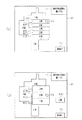
図1に示すように、本実施形態の地図データ管理システム11は、ユーザの所望する国用の地図データを提供可能なシステムである。こうした地図データ管理システム11は、地図データ管理装置としての管理サーバ12と、該管理サーバ12とネットワーク13などを介して各種情報を送受信可能な情報端末14(14a,14b,14c…)とを備えている。
(First embodiment)
Hereinafter, a first embodiment of the present invention will be described with reference to FIGS.
As shown in FIG. 1, the map
管理サーバ12は、通信制御手段としてのサーバ制御部15と、通信部16と、地図記憶手段としての地図記憶部17と、情報記憶手段としての各国情報記憶部18とを備えている。サーバ制御部15は、図示しないCPU、ROM及びRAMなどを有している。そして、サーバ制御部15は、CPUがROMに記憶される各種プログラムを適宜実行することにより、各記憶部17,18に記憶される情報を読み出したり、通信部16に制御指令及び各種情報を出力したりする。
The
通信部16は、サーバ制御部15から制御指令が入力された場合には、その制御指令に基づいた情報を情報端末14(例えば情報端末14a)に送信する。また、通信部16は、情報端末14(14a,14b,14c…)から情報を受信した場合には、該情報をサーバ制御部15に出力する。
When a control command is input from the
地図記憶部17は、一例としてハードディスクで構成されている。こうした地図記憶部17には、情報端末14(14a,14b,14c…)に提供可能な全ての国(本実施形態では5国)の地図情報(即ち、A国用地図情報19A、B国用地図情報19B、C国用地図情報19C、D国用地図情報19D及びE国用地図情報19E)が記憶されている。A国用地図情報19Aは、A国用地図データ20と、経路データ(「経路ネットワークデータ」ともいう。)21と、POI(Point Of Interest)データ22とを有している。同様に、A国以外の他の国用の地図情報19B〜19Eは、各国用の地図データ20と、経路データ21と、POIデータ22とをそれぞれ有している。
The
経路データ21は、ノードに関するノードデータとリンクに関するリンクデータとを有している。ノードは、交差点や道路の端点に設定されるものであって、ノードデータは、ノードの座標や識別子などを含んでいる。また、リンクは、各ノードの間に設定されるものであって、リンクデータは、リンクの識別子、接続ノードの識別子及び経路探索に用いられるリンクコストなどを含んでいる。POIデータ22は、特定の地点や施設(例えば、レストランやホテル)の名称及び特定の地点や施設のジャンル(種別)などのデータを有している。
The
各国用の地図データ20は、各国公認の国境線を含んだ地図データである。しかし、互いに隣接し合う国同士の間では、国境線が確定していないこともある。例えば、図2(a)に示すように、A国とC国とでは、互いに主張し合う国境線の位置が異なっており、A国とC国との国境近傍には、両国が互いに領有権を主張し合う地域(以下、「第1の地域」ともいう。)23が存在する。また、B国とE国とでは、互いに主張し合う国境線の位置が異なっており、B国とE国との国境近傍には、両国が互いに領有権を主張し合う第1の地域24が存在する。また、C国とD国とでは、互いに主張し合う国境線の位置が異なっており、C国とD国との国境近傍には、両国が互いに領有権を主張し合う第1の地域25が存在する。
The
なお、図2(b)に示す地図は、A国公認のA国用地図データ20に基づいた地図であって、この地図には、第1の地域23がA国の領土として描かれている。また、図2(c)に示す地図は、B国公認のB国用地図データ20に基づいた地図であって、この地図には、第1の地域24がB国の領土として描かれている。また、図2(d)に示す地図は、C国公認のC国用地図データ20に基づいた地図であって、この地図には、第1の地域23,25が共にC国の領土として描かれている。また、図2(e)に示す地図は、D国公認のD国用地図データ20に基づいた地図であって、この地図には、第1の地域25がD国の領土として描かれている。そして、図2(f)に示す地図は、E国公認のE国用地図データ20に基づいた地図であって、この地図には、第1の地域24がE国の領土として描かれている。つまり、地図記憶部17には、国毎に区分された地図データ20が記憶されている。
The map shown in FIG. 2 (b) is a map based on the
各国情報記憶部18は、一例としてハードディスクで構成されている。こうした各国情報記憶部18には、図1及び図3に示すように、地図情報を提供可能な国同士の友好関係を示す情報テーブルが格納されている。本実施形態においては、この情報テーブルは、国同士の友好関係に関する情報として、国同士の間で国境が確定しているか否かに関する情報、及び国同士の国交関係が良好であるか否かに関する情報を有している。すなわち、A国とB国との間では国境が確定していると共に、A国とB国との国交関係は非常に良好である。また、A国とC国との間では国境が確定していないと共に、A国とC国との国交関係は険悪である。また、A国とD国との間では国境が確定していると共に、A国とD国との国交関係は非常に良好である。また、A国とE国との間では国境が確定している一方で、A国とE国との国交関係はあまり良好ではない。
The country
B国とC国とは互いに隣接していない一方で、B国とC国との国交関係はあまり良好ではない。また、B国とD国とは互いに隣接していないと共に、B国とD国との国交関係は非常に良好である。また、B国とE国との間では国境が確定していないと共に、B国とE国との国交関係は険悪である。C国とD国との間では国境が確定していないと共に、C国とD国との国交関係は険悪である。また、C国とE国とは互いに隣接していないと共に、C国とE国との国交関係は非常に良好である。D国とE国との間では国境が確定していると共に、D国とE国との国交関係は非常に良好である。 While Country B and Country C are not adjacent to each other, diplomatic relations between Country B and Country C are not very good. In addition, Country B and Country D are not adjacent to each other, and diplomatic relations between Country B and Country D are very good. In addition, the border between Country B and Country E has not been established, and the diplomatic relations between Country B and Country E are steep. The border between Country C and Country D has not been established, and the diplomatic relations between Country C and Country D are poor. In addition, Country C and Country E are not adjacent to each other, and diplomatic relations between Country C and Country E are very good. A border has been established between Country D and Country E, and diplomatic relations between Country D and Country E are very good.
なお、各記憶部17,18に記憶される地図情報19A〜19E及び情報テーブルは、各国の主張の変化(例えば、主張する国境線の位置が変わる)、及び各国の政治的な時事変化(例えば、同盟関係)などに伴って、最新の情報に適宜変更される。
Note that the
次に、情報端末14(14a,14b,14c…)について説明する。
図1に示すように、情報端末14(14a,14b,14c…)は、一例として家庭で用いられる端末であって、管理サーバ12から地図情報をダウンロードし、該地図情報を不揮発性の記憶媒体30に記憶させる装置である。なお、本実施形態において不揮発性の記憶媒体30とは、該記憶媒体30への電力供給が遮断されても記憶内容が保持される記憶媒体を示しており、ハードディスクも含んでいる。
Next, the information terminal 14 (14a, 14b, 14c ...) will be described.
As shown in FIG. 1, the information terminal 14 (14a, 14b, 14c...) Is a terminal used at home as an example, downloads map information from the
情報端末(14a,14b,14c…)は、情報端末本体31と、表示画面32を有する表示手段としての表示装置33と、ユーザによって操作される操作手段としての操作部34(例えば、キーボードやマウス)とを備えている。情報端末本体31は、記憶媒体30が着脱自在な状態で装着されるホルダー部35と、該情報端末14を統括的に制御するコントローラー36とを有している。
The information terminals (14a, 14b, 14c...) Include an information terminal
コントローラー36は、端末制御部37と、画像処理部38と、通信部39と、端末メモリ40とを備えている。端末制御部37は、図示しないCPU、ROM及びRAMなどを有している。そして、端末制御部37は、操作部34の操作状況に応じた制御指令を通信部39や画像処理部38などに出力したり、通信部39を介して受信した情報に基づいた制御指令を画像処理部38に出力したり、情報を記憶媒体30に記憶させたりする。
The
画像処理部38は、端末制御部37からの制御指令に応じた画像が表示画面32に表示されるように表示装置33を制御する。したがって、本実施形態では、端末制御部37及び画像処理部38によって、端末制御手段が構成される。
The
通信部39は、端末制御部37から制御指令が入力された場合には、その制御指令に基づいた情報を管理サーバ12に送信する。また、通信部39は、管理サーバ12から情報を受信した場合には、該情報を端末メモリ40に一時的に記憶させる。
When a control command is input from the
次に、情報端末14で地図情報が記憶された記憶媒体30が装着される車両用のナビゲーション装置について説明する。
図4に示すように、地図表示制御装置としてのナビゲーション装置50は、表示手段としての入出力装置51と、自車両の位置を検出するための位置検出装置52と、該位置検出装置52からの検出結果に基づき各種制御を行うナビ制御装置53と、記憶媒体30が着脱自在に装着されるホルダー部54とを備えている。入出力装置51は、表示画面としてのディスプレイ55と、該ディスプレイ55の前面側に配置される操作手段としてのタッチパネル56と、操作手段としての操作ボタン57とを備えている。また、入出力装置51は、自車両の乗員に対して各種の案内を音声で行うための図示しないスピーカを備えている。
Next, a navigation device for a vehicle to which the
As shown in FIG. 4, a
ディスプレイ55は、カラー液晶ディスプレイを用いている。こうしたディスプレイ55には、詳しくは後述するが、ナビ制御装置53から出力された情報に応じた画像(例えば、地図や目的地を入力させるための画面)が表示される。
The
タッチパネル56は、ディスプレイ55の略全面に亘って重ねられた透明な接触検知用のパネルである。そして、ユーザがディスプレイ55の表示に合わせて指先などをタッチパネル56に接触させた場合には、タッチパネル56のうち接触された位置(「表示領域」ともいう。)に応じた信号がナビ制御装置53に出力される。操作ボタン57は、ディスプレイ55に表示される画像を変更させる際などに操作される。例えば、ディスプレイ55に地図が表示される場合において、目的地設定用のボタン操作がなされたときには、その操作態様に応じた信号がナビ制御装置53に出力される。
The
位置検出装置52は、緯度・経度情報などの自車両の絶対位置に関する情報を図示しない人工衛星から受信するGPS(Global Positioning System )受信部58と、自車両の進行方向を示す方位角情報を検出するジャイロセンサ59と、自車両の走行速度に関する車速情報を検出する車速センサ60となどを備えている。
The
ナビ制御装置53は、センサ入力インターフェース61と、通信インターフェース62と、画像メモリ63と、ナビ制御部64と、画像プロセッサ65とを備えている。また、ナビ制御装置53は、ホルダー部54に装着された記憶媒体30と情報の入出力が可能である。通信インターフェース62には、入出力装置51のタッチパネル56、操作ボタン57、及び位置検出装置52のGPS受信部58からの信号が入力される。センサ入力インターフェース61には、位置検出装置52のジャイロセンサ59及び車速センサ60からのセンサ信号が入力される。
The
画像メモリ63は、ディスプレイ55に地図以外の画像を表示させるための画像データが記憶されている。例えば、画像メモリ63には、自車両の図示しないイグニッションスイッチがオンになった場合にディスプレイ55に表示させる初期画面、及び目的地を入力させるための入力用画面などが記憶されている。
The
ナビ制御部64は、ナビゲーション装置50を統括的に制御するものであって、図示しないCPU、ROM及びRAMなどを備えている。例えば、ナビ制御部64は、GPS受信部58からのGPS信号に基づき自車両の絶対位置を取得した場合には、該自車両の絶対位置周辺の地図をディスプレイ55に表示させる旨の制御指令を画像プロセッサ65に出力する。また、ナビ制御部64は、タッチパネル56や操作ボタン57によって目的地が設定された場合には、自車両の現在位置(即ち、自車両の絶対位置)から目的地までの経路を検索し、該検索された経路を描いた地図をディスプレイ55に表示させる旨の制御指令を画像プロセッサ65に出力する。
The
画像プロセッサ65は、ナビ制御部64から地図をディスプレイ55に表示させる旨の制御指令が入力された場合には、記憶媒体30から地図データを読み出し、画像処理を施してディスプレイ55に地図などを表示させる。また、画像プロセッサ65は、ナビ制御部64から目的地を入力させる旨の制御指令が入力された場合には、画像メモリ63から制御指令に応じた画像データを読み出し、画像処理を施してディスプレイ55に入力画面などを表示させる。したがって、本実施形態では、ナビ制御部64及び画像プロセッサ65により、表示制御手段が構成される。
When a control command for displaying a map on the
次に、本実施形態の地図データ管理システム11を用いて地図情報をユーザがダウンロードする際に、管理サーバ12側で実行される地図情報送信処理ルーチン及び情報端末14側で実行される地図情報取得処理ルーチンについて、図5に示す各フローチャートと、図6、図7及び図8に示す画面の模式図とに基づき説明する。
Next, when the user downloads the map information using the map
始めに、管理サーバ12のサーバ制御部15が実行する地図情報送信処理ルーチンについて説明する。
さて、地図情報送信処理ルーチンにおいて、サーバ制御部15は、通信部16を介して情報端末14から地図情報取得開始情報を受信したか否かを判定する(ステップS1−10)。この地図情報取得開始情報は、該情報を送信した情報端末14(例えば情報端末14a)の識別情報を含んでいる。続いて、サーバ制御部15は、地図情報取得開始情報を送信した情報端末14(例えば情報端末14a)を特定する(ステップS1−11)。そして、サーバ制御部15は、特定された情報端末14で選択された国(例えばA国)に関する国名情報を受信したか否かを判定する(ステップS1−12)。本実施形態では、詳しくは後述するが、地図情報の取得を希望する国は、情報端末14でユーザによって一つずつ選択される。そのため、管理サーバ12は、情報端末14側で国が選択される毎に、該選択された国に関する国名情報を受信する。
First, a map information transmission processing routine executed by the
In the map information transmission processing routine, the
ステップS1−12の判定結果が否定判定である場合、サーバ制御部15は、特定された情報端末14から国名情報を受信するまでステップS1−12の判定処理を繰り返し行う。一方、ステップS1−12の判定結果が肯定判定になった場合、サーバ制御部15は、国名情報を受信したため、警告判別処理を行う(ステップS1−13)。具体的には、サーバ制御部15は、分類処理(後述するステップS1−18)が未実行である場合には、警告判別処理を終了する。一方、サーバ制御部15は、分類処理が実行済みである場合には、ステップS1−12で受信した国名情報に含まれる国(例えばC国)が第1のグループに含まれるのか、第2のグループに含まれるのかを判別する。
When the determination result of step S1-12 is negative, the
警告判別処理が終了すると、サーバ制御部15は、警告判別処理の結果、情報端末14で選択された国が選択禁止国であったか否か(即ち、第2のグループに含まれる国が選択されたか否か)を判定する(ステップS1−14)。したがって、本実施形態では、サーバ制御部15が、選択された国が第1のグループに含まれるのか又は第2のグループに含まれるのかを判定する判定手段としても機能する。また、ステップS1−13,S1−14により、判定ステップが構成される。
When the warning determination process ends, the
ステップS1−14の判定結果が肯定判定である場合、サーバ制御部15は、選択された国(第2国)の選択を禁止する旨の情報として、選択された国が選択禁止国であった旨の警告情報を、ステップS1−11で特定された情報端末14に通信部16から送信させ(ステップS1−15)、その処理を前述したステップS1−12に移行する。一方、ステップS1−14の判定結果が肯定判定である場合、サーバ制御部15は、選択された国が第1のグループに含まれるため、選択された国の地図情報の取得を許可する許可情報を、ステップS1−11で特定された情報端末14に通信部16から送信させる(ステップS1−16)。なお、分類処理が未実行である場合、即ち一国目の選択の場合、サーバ制御部15は、ステップS1−14の判定処理を肯定判定とし、ステップS1−16の処理を行う。
When the determination result of step S1-14 is affirmative determination, the
続いて、サーバ制御部15は、ステップS1−11で特定された情報端末14から選択完了情報を受信したか否かを判定する(ステップS1−17)。この選択完了情報は、情報端末14側で地図情報の取得を所望する国の選択が完了した場合に情報端末14から送信される情報である。ステップS1−17の判定結果が否定判定である場合、サーバ制御部15は、選択完了情報を受信していない(即ち、情報端末14で選択完了情報を送信していない)ため、分類処理を実行する(ステップS1−18)。具体的には、サーバ制御部15は、各国情報記憶部18に記憶される情報テーブルを読み出す。そして、サーバ制御部15は、既に選択された国(例えばA国)と比較的友好度の高い国(この場合、B国、D国、E国)を第1のグループに分類する一方、既に選択された国(例えばA国)と比較的友好度の低い国(この場合、C国)を第1のグループとは異なる第2のグループに分類する。また、サーバ制御部15は、既に選択された国が複数の場合(例えば、A国とB国が選択された場合)、D国を第1のグループに分類する一方、C国及びE国を第2のグループに分類する。
Subsequently, the
なお、本実施形態では、「比較的友好度の高い国」及び「比較的友好度の低い国」は、国同士の友好関係に関する情報の一例として、選択済みとなった国(第1国)との間で国境の位置が確定済みであるか否かによって分類される(図3参照)。すなわち、「比較的友好度の高い国」は、選択済みとなった国との間で国境線の位置が確定している国のことを示す一方、「比較的友好度の低い国」とは、選択済みとなった国との間で国境線の位置が未確定の国のことを示す。 In the present embodiment, “a country with a relatively high degree of friendship” and “a country with a relatively low degree of friendship” are selected countries (first country) as an example of information on friendship between countries. Are classified according to whether or not the position of the border has been determined (see FIG. 3). In other words, “a country with a relatively high degree of friendship” indicates a country where the position of the border line with the selected country has been determined, while “a country with a relatively low degree of friendship” , Indicates the country where the position of the border line with the selected country is uncertain.
そして、サーバ制御部15は、第1のグループ及び第2のグループに関する分類情報を生成する。したがって、本実施形態では、サーバ制御部15が、各国情報記憶部18に記憶される国同士の友好関係に関する情報に基づき、選択済みとなった国(第1国)以外の他の国を第1のグループ及び第2のグループに分類する分類手段としても機能する。また、ステップS1−18が、分類ステップに相当する。
And the
分類処理が終了すると、サーバ制御部15は、ステップS1−18で生成された分類情報を、ステップS1−11で特定された情報端末14に通信部16から送信させる(ステップS1−19)。その後、サーバ制御部15は、その処理を前述したステップS1−12に移行する。
When the classification process ends, the
その一方で、ステップS1−17の判定結果が肯定判定である場合、サーバ制御部15は、選択完了情報を受信したため、地図データ生成処理を行う(ステップS1−20)。すなわち、サーバ制御部15は、選択された国数が一国である場合(例えば、D国のみ選択された場合)には、地図記憶部17からD国用地図情報19Dを読み出して地図データ生成処理を終了する。
On the other hand, when the determination result of step S1-17 is affirmative, the
また、サーバ制御部15は、選択された国数が複数国(例えば3国)である場合には、選択された各国(例えば、A国、B国及びD国)用の各地図情報19A,19B,19Dを地図記憶部17から読み出す。続いて、サーバ制御部15は、各地図情報19A,19B,19Dに含まれる各国用の地図データ20を合成して一つの共通地図データを生成する。同様に、サーバ制御部15は、各地図情報19A,19B,19Dに含まれる各国用の経路データ21及びPOIデータ22を合成し、各国共通の共通経路データ及び共通POIデータを生成する。そして、サーバ制御部15は、生成した共通地図データ、共通経路データ及び共通POIデータを含む共通地図情報を生成する。したがって、本実施形態では、サーバ制御部15が、生成手段としても機能する。また、ステップS1−20が、生成ステップに相当する。
Further, when the number of selected countries is a plurality of countries (for example, three countries), the
地図情報生成処理が終了すると、サーバ制御部15は、ステップS1−20で生成された地図情報(又は共通地図情報)を、ステップS1−11で特定された情報端末14に通信部16から送信させる(ステップS1−21)。したがって、本実施形態では、サーバ制御部15が、通信制御手段としても機能する。また、ステップS1−21が、送信ステップに相当する。
When the map information generation process ends, the
次に、情報端末14の端末制御部37が実行する地図情報取得処理ルーチンについて説明する。この地図情報取得処理ルーチンは、記憶媒体30がホルダー部35に装着されると共に、地図情報を取得するための操作が操作部34で行われた際に実行される。
Next, a map information acquisition process routine executed by the
さて、地図情報取得処理ルーチンにおいて、端末制御部37は、情報端末14の識別情報を含む地図情報取得開始情報を通信部39から送信させる(ステップS2−10)。続いて、端末制御部37は、ユーザに選択を希望する国数を設定させるための画面(以下、「国数設定用画面」ともいう。)を表示画面32に表示させる旨の制御指令を画像処理部38に出力する(ステップS2−11)。すると、画像処理部38は、国数設定用画面を表示画面32に表示させるべく表示装置33を制御する。
In the map information acquisition processing routine, the
そして、端末制御部37は、ユーザによる操作部34の操作によって国数が設定されたか否かを判定する(ステップS2−12)。この判定結果が否定判定である場合、端末制御部37は、国数が設定されるまでステップS2−12の判定処理を繰り返し行う。一方、端末制御部37は、ステップS2−12の判定結果が肯定判定になった場合、国数(例えば3)が設定されたため、設定数Nに「1」をセットする(ステップS2−13)。なお、ここでユーザによって設定された国数に基づき、後述する国数閾値KNが端末制御部37によって設定される。続いて、端末制御部37は、ユーザに地図情報を取得させるための画面(以下、「地図情報取得用画面」ともいう。)を表示画面32に表示させる旨の制御指令を画像処理部38に出力する(ステップS2−14)。このとき、端末制御部37は、管理サーバ12側から分類情報を既に受信している場合、該分類情報に応じた表示態様の地図情報取得用画面を表示させる旨の制御指令を画像処理部38に出力する。すると、画像処理部38は、端末制御部37から入力された制御指令に応じた地図情報取得用画面を表示画面32に表示させるべく表示装置33を制御する。
And the
ここで、分類情報を未だ受信していない場合について説明する。
画像処理部38は、図6(a)に示すように、表示装置33の表示画面32に、選択可能な国に対応する複数(本実施形態では5つ)の表示領域が表示されるように表示装置33を制御する。一例として、A国に対応する表示領域70Aは、A国の外郭形状に応じた形状で表示されると共に、B国に対応する表示領域70Bは、B国の外郭形状に応じた形状で表示される。また、C国に対応する表示領域70Cは、C国の外郭形状に応じた形状で表示されると共に、D国に対応する表示領域70Dは、D国の外郭形状に応じた形状で表示される。そして、E国に対応する表示領域70Eは、E国の外郭形状に応じた形状で表示される。ただし、互いに隣り合う国同士の間で領有権を主張し合う第1の地域23,24,25に相当する領域については、両国が主張する国境線に相当する位置を破線で示すことにより表示される。
Here, the case where the classification information has not been received will be described.
As shown in FIG. 6A, the
また、画像処理部38は、表示画面32の右上に、ステップS2−12で設定された国数(図6(a)では3)に基づき、ユーザに選択させることが可能な国数に関する情報を示す表示領域(以下、「選択可能国数表示領域」ともいう。)71を表示させる。また、画像処理部38は、表示画面32において選択可能国数表示領域71の下側に、選択を終了する際に選択される表示領域(以下、「選択終了用表示領域」ともいう。)72を表示させる。さらに、画像処理部38は、ユーザによる操作部34の操作状況に応じて移動する矢印73(例えば、マウスポインタ)を表示画面32に表示させる。この矢印73は、表示画面32においてユーザによる操作部34の操作に応じた位置に移動可能である。
Further, the
次に、第1国としてA国が選択された際に分類情報を受信した場合について説明する。
画像処理部38は、図6(b)に示すように、表示装置33の表示画面32上において、第1のグループに含まれる国に対応する表示領域と、第2のグループに含まれる国に対応する表示領域とで表示態様が異なるように表示装置33を制御する。一例として、画像処理部38は、第1のグループに含まれる国(B国、D国及びE国)に対応する表示領域70B,70D,70Eの輝度を、図6(a)の場合の輝度と同等に維持させる。一方、画像処理部38は、第2のグループに含まれる国(C国)に対応する表示領域70Cの輝度を、図6(a)の場合の輝度よりも低くさせる。このとき、画像処理部38は、A国とC国とが互いに領有権を主張し合う第1の地域23に相当する部分をA国の領土と見なした表示を行わせる。なお、画像処理部38は、選択済みとなったA国に対応する表示領域70Aの色相を、選択されていない他の国に対応する表示領域70B〜70Eの色相と変更させてもよい。
Next, a case where classification information is received when country A is selected as the first country will be described.
As shown in FIG. 6B, the
また、画像処理部38は、既に一国(この場合、A国)が選択されたため、選択可能国数表示領域71の表示内容をA国が選択される前から変更(即ち、国数を3から2に変更)させる。
In addition, since one country (in this case, country A) has already been selected, the
次に、A国及びB国が選択されたことを契機に管理サーバ12から送信された分類情報を情報端末14が受信した場合について説明する。
画像処理部38は、図7(a)に示すように、第1のグループに含まれる国(D国)に対応する表示領域70Dの輝度を、図6(a)の場合の輝度と同等に維持させる。一方、画像処理部38は、第2のグループに含まれる国(C国及びE国)に対応する表示領域70C,70Eの輝度を、図6(a)の場合の輝度よりも低くさせる。これは、E国は、A国との間では国境線の位置が確定している一方、B国との間で国境線の位置が確定していないためである(図3参照)。このとき、画像処理部38は、A国とC国とが互いに領有権を主張し合う第1の地域23に相当する部分をA国の領土と見なして表示させると共に、B国とE国とが互いに領有権を主張し合う第1の地域24に相当する部分をB国の領土と見なして表示させる。
Next, the case where the
As shown in FIG. 7A, the
また、画像処理部38は、既に二国(この場合、A国及びB国)が選択されたため、選択可能国数表示領域71の表示内容をB国が選択される前から変更(即ち、国数を2から1に変更)させる。
Further, since two countries (in this case, Country A and Country B) have already been selected, the
図5に戻り、端末制御部37は、ユーザによる操作部34の操作によって、N国目(Nが1の場合には1国目)が選択されたか否かを判定する(ステップS2−15)。この判定結果が否定判定である場合、端末制御部37は、N国目が未選択であるため、N国目が選択されるまでステップS2−15の処理を繰り返し行う。ただし、N国目が未選択であっても表示画面32の選択終了用表示領域72がユーザによる操作部34の操作によって選択された場合、端末制御部37は、その処理を強制的に後述するステップS2−22に移行する。
Returning to FIG. 5, the
一方、ステップS2−15の判定結果が肯定判定になった場合、端末制御部37は、N国目が選択されたため、該選択された国名(例えば、A国)に関する国名情報を通信部39から管理サーバ12に送信させる(ステップS2−16)。続いて、端末制御部37は、管理サーバ12から警告情報を受信したか否かを判定する(ステップS2−17)。この判定結果が肯定判定である場合、端末制御部37は、警告情報を受信したため、無効表示処理を行う(ステップS2−18)。具体的には、端末制御部37は、その選択が無効である旨、即ち第2国の選択が禁止である旨を報知させる旨の制御指令を画像処理部38に出力する。すると、画像処理部38は、図7(b)に示す警告画面を表示画面32に表示させるべく表示装置33を制御する。
On the other hand, if the determination result in step S2-15 is affirmative, the
例えば、選択禁止国としてE国が選択された場合、画像処理部38は、図7(b)に示すように、表示画面32に、「E国を選択することはできません。」という旨の記載を有する表示領域73を形成させる。この表示領域73内には、「OK(即ち、了承)」という旨の記載を有する表示領域(以下、「了承用表示領域」ともいう。)73aが形成される。そして、端末制御部37は、了承用表示領域73aが操作部34の操作によって選択された場合に、上記表示領域73を表示画面32から消去させる旨を画像処理部38に出力する。すると、画像処理部38は、表示画面32から表示領域73を消去させる。その後、端末制御部37は、その処理を次のステップS2−14に移行する。
For example, when country E is selected as the selection-prohibited country, the
一方、ステップS2−17の判定結果が否定判定である場合、端末制御部37は、許可情報を受信したため、現時点の設定数Nが、ステップS2−12で設定された国数に基づき設定された国数閾値KN未満であるか否かを判定する(ステップS2−19)。本実施形態では、国数閾値KNは、端末制御部37によって、ステップS2−12で設定された国数と同一値に設定される。したがって、本実施形態では、端末制御部37が、閾値設定手段としても機能する。
On the other hand, when the determination result of step S2-17 is negative, since the
ステップS2−19の判定結果が否定判定(N=KN)である場合、端末制御部37は、その処理を後述するステップS2−22に移行する。一方、ステップS2−19の判定結果が肯定判定(N<KN)である場合、端末制御部37は、管理サーバ12から分類情報を受信したか否かを判定する(ステップS2−20)。この判定処理が否定判定である場合、端末制御部37は、分類情報を受信するまでステップS2−20の判定処理を繰り返し行う。一方、ステップS2−20の判定結果が肯定判定になった場合、端末制御部37は、分類情報を受信したため、設定数Nを「1」だけインクリメントし(ステップS2−21)、その処理を前述したステップS2−14に移行する。
If the determination result of step S2-19 is negative (N = KN), the
ステップS2−22において、端末制御部37は、国の選択が完了したことをユーザに報知させる旨を画像処理部38に出力する。すると、画像処理部38は、図8(a)に示すように、「地図情報を取得する国の選択が完了しました。」という旨の記載を有する表示領域74を表示画面32の中央に形成させる。この表示領域74内には、「OK(即ち、了承)」という旨の記載を有する表示領域(以下、「了承用表示領域」ともいう。)74aと、「やり直し」という旨の記載を有する表示領域(以下、「無効用表示領域」ともいう。)74bとを有している。
In step S2-22, the
図5に戻り、端末制御部37は、了承用表示領域74aがユーザの操作部34の操作によって選択されたか否かを判定する(ステップS2−23)。端末制御部37は、無効用表示領域74bが選択された場合(ステップS2−23が否定判定)には、その処理を前述したステップS2−11に移行する。すなわち、端末制御部37は、国の選択をユーザに最初から行わせる。
Returning to FIG. 5, the
一方、端末制御部37は、了承用表示領域74aが選択された場合(ステップS2−23が肯定判定)には、国の選択が完了した旨の選択完了情報を通信部39から管理サーバ12に送信させる(ステップS2−24)。続いて、端末制御部37は、管理サーバ12から地図情報の受信が完了したか否かを判定する(ステップS2−25)。この判定結果が否定判定である場合、端末制御部37は、地図情報を受信中であるため、その旨を報知させる制御指令を画像処理部38に出力すると共に、地図情報の受信が完了するまでステップS2−25の判定処理を繰り返し行う。このとき、図8(b)に示すように、画像処理部38は、表示画面32の中央に、「ダウンロード中です。しばらくお待ち下さい。」という旨の記載を有する表示領域75を形成させるべく表示装置33を制御する。
On the other hand, when the
図5に戻り、ステップS2−25の判定結果が肯定判定になった場合、端末制御部37は、受信した地図情報を端末メモリ40に一旦記憶させた後に記憶媒体30にコピーしたため、その旨を報知させる制御指令を画像処理部38に出力する。すると、画像処理部38は、表示画面32の中央に「ダウンロードが完了しました。」という旨の記載を有する表示領域を形成させるべく表示装置33を制御する。そして、端末制御部37は、上記表示制御を所定時間(例えば5秒)の間行った後、地図情報取得処理ルーチンを終了する。
Returning to FIG. 5, if the determination result in step S2-25 is affirmative, the
次に、地図データ管理システム11を用いて地図情報が記憶された記憶媒体30を搭載したナビゲーション装置50のナビ制御部64が実行する切り替え判定処理ルーチンについて図9に示すフローチャートに基づき説明する。この切り替え判定処理ルーチンは、自車両の現在位置を、現時点で用いられる地図情報では表示できない場合に、その旨を報知する処理である。
Next, the switching determination processing routine executed by the
さて、ナビ制御部64は、予め設定された所定周期(例えば、0.1秒周期)毎に切り替え判定処理ルーチンを実行する。この切り替え判定処理ルーチンにおいて、ナビ制御部64は、GPS受信部58から入力されるGPS信号に基づき、自車両の現在位置を取得する(ステップS3−10)。続いて、ナビ制御部64は、ステップS3−10で取得された自車両の現在位置が現時点で表示可能な地図上には位置しないか否かを判定する(ステップS3−11)。すなわち、ナビ制御部64は、入出力装置51のディスプレイ55に地図を表示させる際に使用される地図情報(即ち、地図データ)で、自車両の現在位置を表示できないか否かを判定する。ステップS3−11の判定結果が否定判定である場合、ナビ制御部64は、現時点で使用される地図情報で、自車両の現在位置周辺の地図をディスプレイ55に表示させることが可能であるため、切り替え判定処理ルーチンを一旦終了する。
Now, the
一方、ステップS3−11の判定結果が肯定判定である場合、ナビ制御部64は、現時点で使用される地図情報で、自車両の現在位置周辺の地図をディスプレイ55に表示させることが不能であるため、切り替え報知処理を実行する(ステップS3−12)。すなわち、ナビ制御部64は、自車両の現在位置周辺の地図を表示させることができない旨及び使用する地図情報の変更を促す旨の制御指令を画像プロセッサ65に出力する。すると、画像プロセッサ65は、自車両の現在位置周辺の地図を表示させることができない旨及び使用する地図情報の変更を促す旨を、ディスプレイ55に表示させるべく入出力装置51を制御する。その後、ナビ制御部64は、切り替え判定処理ルーチンを終了する。
On the other hand, if the determination result of step S3-11 is affirmative, the
したがって、本実施形態では、以下に示す効果を得ることができる。
(1)管理サーバ12では、第1国(例えばA国)に関する国名情報が情報端末14から受信されると、地図情報を提供可能な全ての国のうち第1国以外の他の国(この場合、B国、C国、D国及びE国)が、第1のグループと第2のグループとに分類される。その後、第1のグループに含まれる第2国(例えばB国)に関する国名情報及び選択完了情報が情報端末14から受信された場合には、地図記憶部17に記憶される第1国用及び第2国用の地図情報(この場合、A国用地図情報19A及びB国用地図情報19B)に基づき第1国及び第2国を含む共通地図情報が生成され、該共通地図情報が情報端末14に送信される。そのため、最新の各国用の地図情報19A〜19E及び最新の国同士の友好関係に関する情報テーブルを各記憶部17,18に記憶させておくことにより、国同士の友好関係に基づき、第1国及び第2国を含む最新の地図情報を情報端末14側に提供することができる。
Therefore, in this embodiment, the following effects can be obtained.
(1) In the
(2)管理サーバ12には、第2のグループに含まれる国に関する情報が情報端末14から受信されることがある。そこで、本実施形態では、情報端末14で選択された国(第2国)に関する情報が管理サーバ12で受信された場合、該管理サーバ12では、情報端末14で選択された国が、第1のグループに含まれるか否かが判定される。そして、選択された国が第1のグループに含まれる場合には、その後に選択完了情報が受信されることを契機に、選択済みとなった各国の地図情報を含む共通地図情報が生成され、該生成された共通地図情報が情報端末14に送信される。そのため、国同士の友好関係上、組み合わせてもよいと判断された複数の国の共通地図情報を、ユーザに提供できる。
(2) The
(3)その一方で、情報端末14で選択された国が第2のグループに含まれる場合には、その国の選択が禁止される。すなわち、選択された国用の地図データを情報端末14に送信させることが禁止される。したがって、国同士の友好関係上、組み合わせることが好ましくない複数の国(例えばA国とC国)の共通地図情報がユーザに提供されることを抑制できる。
(3) On the other hand, when the country selected by the
(4)本実施形態では、ナビゲーション装置50から着脱可能な記憶媒体30に対して、情報端末14を用いて最新の地図情報を記憶させることができる。そのため、ユーザの意向に合致するだけではなく各国の情勢の変化に応じた適切な地図情報でもって、車両の乗員に対して地図を提供させることができると共に、目的地までの経路を適切に案内できる。
(4) In the present embodiment, the latest map information can be stored in the
(5)管理サーバ12側では、情報端末14側から国名情報が受信される毎に分類処理が実行される。そのため、管理サーバ12では、最新の分類情報に従って選択禁止国が選択されたか否かを判定することができる。
(5) On the
(6)本実施形態の情報端末14で分類情報が受信されると、表示画面32では、第1のグループに分類される国に対応する表示領域と、第2のグループに分類される国に対応する表示領域とが互いに異なる表示態様で表示される。そのため、既に選択された第1国と組み合わせることができない国(即ち、選択禁止国)をユーザに対して視覚的に認識させることができる。したがって、選択禁止国がユーザに選択されることを抑制できる。
(6) When the classification information is received by the
しかも、情報端末14には、管理サーバ12で分類処理が行われる毎に、最新の分類情報が受信される。そして、最新の分類情報に基づき、表示画面32を有する表示装置33の表示制御を行うことができる。したがって、選択禁止国がユーザに選択されることを抑制できる。
Moreover, the
(7)より具体的には、第2のグループに分類される国に対応する表示領域の輝度は、第1のグループに分類される国に対応する表示領域の輝度よりも低くなる。そのため、表示画面32では、第1のグループに分類される国に対応する表示領域が強調されて表示される。したがって、ユーザに誤って選択禁止国を選択させることを抑制でき、友好国同士で構成される共通地図情報の速やかな提供に貢献できる。
(7) More specifically, the brightness of the display area corresponding to the country classified into the second group is lower than the brightness of the display area corresponding to the country classified into the first group. Therefore, on the
(8)また、情報端末14の表示画面32には、選択可能国数表示領域71が表示される。そのため、ユーザは、選択可能な国数を視認しながら国を選択することになる。したがって、ユーザに対して効率良く国を選択させることができる。
(8) In addition, a selectable country
(9)本実施形態のナビゲーション装置50では、地図データ管理システム11で生成された地図情報が記憶された記憶媒体30が装着されることにより、自車両の走行中に、該自車両の現在位置周辺の地図がディスプレイ55に表示される。そのため、最新の国際情勢に応じた地図を車両の乗員に提供できる。しかも、最新の地図を入手するために、ユーザが自車両をディーラーなどに持っていく手間を省くことができる。
(9) In the
(10)例えばA国及びB国用の地図データを含む共通地図情報に基づいた地図をディスプレイ55に表示させる際において、自車両がA国及びB国以外の国(例えばE国)に入国した場合には、現時点で使用する共通地図情報では地図の表示を行うことができない旨が自車両の乗員に報知される。そのため、E国を自車両で走行したい乗員に対して、E国用の地図情報の取得を促すことができる。
(10) For example, when displaying a map based on common map information including map data for Country A and Country B on the
(11)さらに、A国の地図情報を有する自車両が第1の地域23内を走行する場合、自車両の乗員に対しては、A国内を走行中であることを認識させることができる。その一方で、C国の地図情報を有する自車両が第1の地域23内を走行する場合、自車両の乗員に対しては、C国内を走行中であることを認識させることができる。
(11) Furthermore, when the host vehicle having the map information of country A travels within the
(第2の実施形態)
次に、本発明の第2の実施形態を図10及び図11に従って説明する。なお、第2の実施形態は、地図情報取得処理ルーチン及び地図情報送信処理ルーチンの内容の一部、及び情報端末の表示画面の表示態様が第1の実施形態と異なっている。したがって、以下の説明においては、第1の実施形態と相違する部分について主に説明するものとし、第1の実施形態と同一又は相当する部材構成には同一符号を付して重複説明を省略するものとする。
(Second Embodiment)
Next, a second embodiment of the present invention will be described with reference to FIGS. The second embodiment is different from the first embodiment in part of the contents of the map information acquisition processing routine and the map information transmission processing routine and the display mode of the display screen of the information terminal. Therefore, in the following description, parts different from those of the first embodiment will be mainly described, and the same or corresponding member configurations as those of the first embodiment are denoted by the same reference numerals, and redundant description will be omitted. Shall.
管理サーバ12側で実行される地図情報送信処理ルーチン及び情報端末14側で実行される地図情報取得処理ルーチンについて、図10に示す各フローチャートと、図11に示す画面の模式図とに基づき説明する。
A map information transmission processing routine executed on the
始めに、サーバ制御部15が実行する地図情報送信処理ルーチンについて説明する。
さて、地図情報送信処理ルーチンが開始されると、サーバ制御部15は、ステップS1−10〜S1−12の各処理を順次行う。そして、ステップS1−12の判定結果が肯定判定になった場合、サーバ制御部15は、国名情報を受信したため、ステップS1−17〜S1−21の各処理を順次行う。その後、サーバ制御部15は、地図情報取得処理ルーチンを終了する。
First, a map information transmission processing routine executed by the
Now, when the map information transmission process routine is started, the
次に、端末制御部37が実行する地図情報取得処理ルーチンについて説明する。
さて、地図情報取得処理ルーチンが開始されると、端末制御部37は、ステップS2−10〜S2−14の各処理を順次行う。すると、画像処理部38は、端末制御部37から入力された制御指令に応じた地図情報取得用画面を表示画面32に表示させるべく表示装置33を制御する。
Next, a map information acquisition process routine executed by the
Now, when the map information acquisition process routine is started, the
ここで、分類情報を未だ受信していない場合について説明する。
画像処理部38は、図11(a)に示すように、A国、B国、C国、D国及びE国用の略長方形状の表示領域80A,80B,80C,80D,80Eを表示画面32の略中央に配置させる。このとき、全ての国が選択可能であるため、各表示領域80A〜80Eは、互いに同一の広さを有すると共に、上下方向にそれぞれ並置されている。
Here, the case where the classification information has not been received will be described.
As shown in FIG. 11A, the
次に、第1国としてA国が選択された際に分類情報を受信した場合について説明する。
画像処理部38は、図11(b)に示すように、選択済みであるA国用の表示領域80Aを表示画面32から消去させる。また、画像処理部38は、A国が選択された場合にはC国が第2のグループに含まれるため(図3参照)、C国用の表示領域80Cを表示画面32の中央から右端側に移動させると共に、表示領域80Cの広さを図11(a)の場合よりも狭くさせる。さらに、画像処理部38は、表示画面32の中央に配置されるB国、D国及びE国用の表示領域80B,80D,80Eを図11(a)の場合よりも広くさせる。
Next, a case where classification information is received when country A is selected as the first country will be described.
As shown in FIG. 11B, the
図10に戻り、端末制御部37は、選択が禁止された国(以下、「選択禁止国」ともいう。)が選択されたか否かを判定する(ステップS2−141)。選択禁止国とは、第2のグループに含まれる国のことであって、既に選択された国や国数(即ち、最新の分類情報)に応じて適宜変更される。一例として、A国のみが既に選択された場合、C国が選択禁止国に該当する。また、A国及びB国が既に選択されている場合、C国及びE国が選択禁止国に該当する。そして、ステップS2−141の判定結果が否定判定である場合、端末制御部37は、選択禁止国が選択されていないため、その処理を後述するステップS2−15に移行する。一方、ステップS2−141の判定結果が肯定判定である場合、端末制御部37は、選択禁止国が選択されたため、ステップS2−18に相当する処理を行う。この無効表示処理が終了すると、端末制御部37は、その処理を次のステップS2−15に移行する。
Returning to FIG. 10, the
ステップS2−15において、端末制御部37は、ユーザによる操作部34の操作に基づきN国目が選択されたか否かを判定する。この判定結果が否定判定である場合、端末制御部37は、N国目が未選択であるため、その処理を前述したステップS2−141に移行する。一方、ステップS2−15の判定結果が肯定判定になった場合、端末制御部37は、ステップS2−19以降の各処理を順次行う。その後、端末制御部37は、地図情報取得処理ルーチンを終了する。
In step S2-15, the
したがって、本実施形態では、上記第1の実施形態の効果(1)(4)(6)、(8)〜(11)の効果に加え、以下に示す効果を得ることができる。
(12)本実施形態では、情報端末14から管理サーバ12に国名情報が送信されると、情報端末14には、第1のグループ及び第2のグループに関する分類情報が受信される。そして、情報端末14では、受信した分類情報に基づき、第2のグループに含まれる国の選択が禁止される。そのため、既に選択された第1国との組み合わせの関係上、選択禁止国に相当する第2国に関する国名情報が情報端末14から管理サーバ12側に送信されることを抑制できる。したがって、第1国と第2のグループに含まれる第2国との共通地図データが生成されることを抑制できる。
Therefore, in this embodiment, in addition to the effects (1), (4), (6), and (8) to (11) of the first embodiment, the following effects can be obtained.
(12) In this embodiment, when the country name information is transmitted from the
(13)また、本実施形態では、第2のグループに分類される国に対応する表示領域は、第1のグループに分類される国に対応する表示領域よりも狭く表示される。そのため、表示画面32では、第1のグループに分類される国に対応する表示領域が強調されて表示される。したがって、ユーザに誤って選択禁止国を選択させることを抑制でき、友好国同士で構成される共通地図情報の速やかな提供に貢献できる。
(13) In the present embodiment, the display area corresponding to the country classified into the second group is displayed narrower than the display area corresponding to the country classified into the first group. Therefore, on the
(14)さらに、第1のグループに分類される国に対応する表示領域は、表示画面32の中央で表示される一方で、第2のグループに分類される国に対応する表示領域は、表示画面32の端部(図11(b)では右側)に表示される。そのため、第2のグループに分類される国に対応する表示領域が表示画面32の中央に表示される場合と比較して、第2のグループに分類される国が選択される可能性を低くさせることができる。
(14) Further, the display area corresponding to the country classified into the first group is displayed at the center of the
(第3の実施形態)
次に、本発明の第3の実施形態を図12及び図13に従って説明する。なお、第3の実施形態は、情報端末の端末メモリに情報テーブルを記憶させる点と、地図情報取得処理ルーチン及び地図情報送信処理ルーチンの内容の一部と、情報端末の表示画面の表示態様とが第1及び第2の各実施形態と異なっている。したがって、以下の説明においては、第1及び第2の各実施形態と相違する部分について主に説明するものとし、第1及び第2の各実施形態と同一又は相当する部材構成には同一符号を付して重複説明を省略するものとする。
(Third embodiment)
Next, a third embodiment of the present invention will be described with reference to FIGS. In the third embodiment, the information table is stored in the terminal memory of the information terminal, part of the contents of the map information acquisition process routine and the map information transmission process routine, and the display mode of the display screen of the information terminal Is different from the first and second embodiments. Therefore, in the following description, parts different from the first and second embodiments will be mainly described, and the same reference numerals are given to the same or corresponding member configurations as those of the first and second embodiments. A duplicate description will be omitted.
本実施形態の情報端末14の端末メモリ40には、図3に示す情報テーブルを記憶する記憶領域が形成されている。したがって、本実施形態では、端末メモリ40が、国同士の友好関係に関する情報を記憶する情報記憶手段として機能する。
A storage area for storing the information table shown in FIG. 3 is formed in the
次に、管理サーバ12側で実行される地図情報送信処理ルーチン及び情報端末14側で実行される地図情報取得処理ルーチンについて、図12に示す各フローチャートと、図13に示す画面の模式図とに基づき説明する。
Next, regarding the map information transmission processing routine executed on the
始めに、サーバ制御部15が実行する地図情報送信処理ルーチンについて説明する。
さて、地図情報送信処理ルーチンが開始されると、サーバ制御部15は、ステップS1−10,S1−11の各処理を順次行う。続いて、サーバ制御部15は、各国名情報を受信したか否かを判定する(ステップS1−121)。この各国名情報は、情報端末14で選択された複数又は一つの国に関する情報である。すなわち、本実施形態では、上記各実施形態とは異なり、情報端末14側で国の選択が完了した時点で、選択された国に関する情報が纏めて管理サーバ12に送信される。
First, a map information transmission processing routine executed by the
Now, when the map information transmission process routine is started, the
ステップS1−121の判定処理が否定判定である場合、サーバ制御部15は、各国名情報を受信するまでステップS1−121の判定処理を繰り返し行う。一方、ステップS1−121の判定結果が肯定判定になった場合、サーバ制御部15は、各国名情報を受信したため、ステップS1−20,S1−21の各処理を順次行い、その後、地図情報送信処理ルーチンを終了する。
If the determination process in step S1-121 is negative, the
次に、端末制御部37が実行する地図情報取得処理ルーチンについて説明する。
さて、地図情報取得処理ルーチンが開始されると、端末制御部37は、上記ステップS2−10〜S2−14の各処理を順次行う。すると、画像処理部38は、端末制御部37から入力された制御指令に応じた地図情報取得用画面を表示画面32に表示させるべく表示装置33を制御する。後述する分類処理(ステップS2−201)が未実行である場合、即ち設定数Nが「1」である場合、画像処理部38は、図13(a)に示すように、第1の実施形態の場合と略同等の画面を表示画面32に表示させるべく表示装置33を制御する。その一方で、分類処理(ステップS2−201)が実行された場合、即ち設定数Nが「1」よりも大きい場合、分類処理の結果に基づいた地図情報取得用画面を表示画面32に表示させる。
Next, a map information acquisition process routine executed by the
Now, when the map information acquisition process routine is started, the
ここで、既に第1国としてA国が選択された場合について説明する。この場合、分類処理によって、B国、D国及びE国は第1のグループに含まれる一方で、C国は第2のグループに含まれる(図3参照)。すなわち、画像処理部38は、図13(b)に示すように、第2のグループに含まれるC国用の表示領域70Cを表示画面32から消去させる。
Here, a case where country A is already selected as the first country will be described. In this case, country B, country D, and country E are included in the first group by the classification process, while country C is included in the second group (see FIG. 3). That is, the
図12に戻り、端末制御部37は、ステップS2−15,S2−141,S2−18の各処理を行う。そして、ステップS2−141の判定結果が否定判定である場合、端末制御部37は、選択禁止国が選択されていないため、ステップS2−19の判定処理を行う。この判定結果が肯定判定(N<KN)である場合、端末制御部37は、分類処理を行う(ステップS2−201)。具体的には、端末制御部37は、端末メモリ40に記憶される情報テーブルを読み出す。そして、端末制御部37は、既に選択された国(例えばA国)と比較的友好度の高い国(この場合、B国、D国、E国)を第1のグループに分類する一方、既に選択された国(例えばA国)と比較的友好度の低い国(この場合、C国)を第2のグループに分類する。また、端末制御部37は、既に選択された国が複数の場合(例えば、A国とB国が選択された場合)、D国を第1のグループに分類する一方、C国及びE国を第2のグループに分類する。
Returning to FIG. 12, the
分類処理が終了すると、端末制御部37は、ステップS2−21の処理を行い、その処理を前述したステップS2−14に移行する。
一方、ステップS2−19の判定結果が否定判定(N=KN)である場合、端末制御部37は、ステップS2−22,S2−23の各処理を順次行う。ステップS2−23の判定結果が肯定判定である場合、端末制御部37は、各国名情報を通信部39から送信させる(ステップS2−241)。例えば、情報端末14でユーザによってA国、B国及びD国が選択された場合、端末制御部37は、複数国(この場合、A国、B国及びD国)に関する各国名情報を通信部39から送信させる。なお、選択された国が一国(例えばE国のみ)である場合、端末制御部37は、一国(この場合、E国)に関する情報を各国名情報として通信部39から送信させる。
When the classification process ends, the
On the other hand, when the determination result of step S2-19 is negative (N = KN), the
続いて、端末制御部37は、ステップS2−25の判定処理を行う。そして、この判定結果が肯定判定になった場合に、端末制御部37は、地図情報の受信が完了したため、地図情報取得処理ルーチンを終了する。
Subsequently, the
したがって、本実施形態では、上記第1及び第2の各実施形態の効果(4)(8)〜(11)の効果に加え、以下に示す効果を得ることができる。
(15)本実施形態では、情報テーブルは、情報端末14の端末メモリ40に記憶されている。そのため、情報端末14では、ユーザによって第1国(例えばA国)が選択された場合には、該選択された国以外の他の国(この場合、B国、C国、D国及びE国)に関して分類処理が行われる。その後、選択された国(第2国)が第1のグループに含まれる場合には、その選択が許可される一方で、選択された国(第2国)が第2のグループに含まれる場合には、その選択が無効とされる。そして、情報端末14で国の選択が完了すると、選択された国に関する各国名情報が管理サーバ12に送信される。
Therefore, in this embodiment, in addition to the effects (4), (8) to (11) of the first and second embodiments, the following effects can be obtained.
(15) In this embodiment, the information table is stored in the
すると、管理サーバ12では、受信した各国名情報に対応する複数の国の共通地図情報が生成され、該生成された共通地図情報が情報端末14に送信される。そのため、最新の各国用の地図情報19A〜19Eを地図記憶部17に記憶させておくことにより、国同士の友好関係に基づき、第1国及び第2国を含む最新の地図情報を情報端末14側に提供することができる。
Then, in the
(16)また、本実施形態では、分類処理が情報端末14で実行されるため、上記各実施形態と比較して、管理サーバ12側の制御負荷を低減させることができる。
(17)さらに、本実施形態では、第2のグループに分類される国に対応する表示領域は、表示画面32から消去される。そのため、ユーザに選択禁止国を選択させることを確実に防止できる。
(16) In this embodiment, since the classification process is executed by the
(17) Further, in the present embodiment, the display area corresponding to the country classified in the second group is erased from the
(第4の実施形態)
次に、本発明の第4の実施形態を図14及び図15に従って説明する。なお、第4の実施形態は、地図情報取得処理ルーチンを実行する情報端末で地図情報を用いて地図をユーザに提供する点が第1〜第3の各実施形態と異なっている。したがって、以下の説明においては、第1〜第3の各実施形態と相違する部分について主に説明するものとし、第1〜第3の各実施形態と同一又は相当する部材構成には同一符号を付して重複説明を省略するものとする。
(Fourth embodiment)
Next, a fourth embodiment of the present invention will be described with reference to FIGS. Note that the fourth embodiment differs from the first to third embodiments in that a map is provided to the user using map information at an information terminal that executes a map information acquisition processing routine. Therefore, in the following description, portions different from the first to third embodiments will be mainly described, and the same reference numerals are given to the same or corresponding member configurations as the first to third embodiments. A duplicate description will be omitted.
図14に示すように、本実施形態の地図データ管理システム11Aは、管理サーバ12と、情報端末14A(例えば、携帯電話などの移動体通信機器)とを備えている。情報端末14Aは、管理サーバ12から地図情報を受信し、該地図情報に基づいた地図を情報端末14Aのユーザに提供することが可能な端末である。こうした情報端末14Aは、操作手段としての操作部34及びコントローラー36に加え、表示画面32を有する表示手段としての表示装置33をさらに備えている。また、コントローラー36は、端末制御部37、画像処理部38、通信部39及び端末メモリ40に加え、GPS受信部90をさらに有している。
As shown in FIG. 14, the map
次に、本実施形態の地図データ管理システム11Aを用いて地図情報をユーザがダウンロードする際に、管理サーバ12で実行される地図情報送信処理ルーチン及び情報端末14Aで実行される地図情報取得処理ルーチンについて、図15に示す各フローチャートに基づき説明する。
Next, when the user downloads the map information using the map
始めに、サーバ制御部15が実行する地図情報送信処理ルーチンについて説明する。
さて、地図情報送信処理ルーチンにおいて、サーバ制御部15は、ステップS1−10,S1−11の各処理を順次行う。続いて、サーバ制御部15は、設定数Nに「1」をセットし(ステップS1−111)、ステップS1−11で特定された情報端末14Aから選択可能国数情報を受信したか否かを判定する(ステップS1−112)。この選択可能国数情報は、情報端末14A側でユーザが地図情報の取得を希望する国数(例えば3)に関する情報である。ステップS1−112の判定結果が否定判定である場合、サーバ制御部15は、選択可能国数情報を受信するまでステップS1−112の判定処理を繰り返し行う。一方、ステップS1−112の判定結果が肯定判定になった場合、サーバ制御部15は、選択可能国数情報を受信したため、ステップS1−12の判定処理を行う。
First, a map information transmission processing routine executed by the
In the map information transmission process routine, the
ステップS1−12の判定結果が肯定判定になった場合、サーバ制御部15は、国名情報を受信したため、ステップS1−13の処理を行う。警告判別処理が終了すると、サーバ制御部15は、警告判別処理の結果に基づき、ステップS1−14の判定処理を行う。この判定結果が肯定判定である場合、サーバ制御部15は、ステップS1−15の処理を行い、その処理を前述したステップS1−12に移行する。
If the determination result of step S1-12 is affirmative, the
一方、ステップS1−14の判定結果が否定判定である場合、サーバ制御部15は、選択された国が第1のグループに含まれるため、ステップS1−16の処理を行い、現時点の設定数Nが、受信された選択可能国数情報に基づき設定された国数閾値KN未満であるか否かを判定する(ステップS1−161)。国数閾値KNは、情報端末14A側で選択された国数と同一値に設定される。そして、ステップS1−161の判定結果が肯定判定(N<KN)である場合、サーバ制御部15は、ステップS1−18の処理を行う。続いて、サーバ制御部15は、設定数Nを「1」だけインクリメントし(ステップS1−181)、その処理を前述したステップS1−12に移行する。
On the other hand, if the determination result of step S1-14 is negative, the
その一方で、ステップS1−161の判定結果が否定判定(N=KN)である場合、サーバ制御部15は、国の選択が完了した旨の選択完了情報を、ステップS1−11で特定された情報端末14Aに通信部16から送信させる(ステップS1−182)。続いて、サーバ制御部15は、ステップS1−20,S1−21の各処理を順次行い、その後、地図情報送信処理ルーチンを終了する。
On the other hand, when the determination result of step S1-161 is negative (N = KN), the
次に、情報端末14Aの端末制御部37が実行する地図情報送信処理ルーチンについて説明する。この地図情報取得処理ルーチンは、地図情報を取得するための操作が操作部34で行われた際に実行される。
Next, a map information transmission processing routine executed by the
さて、地図情報取得処理ルーチンにおいて、端末制御部37は、上記ステップS2−10〜S2−12の各処理を順次行う。そして、ステップS2−12の判定結果が肯定判定になった場合、端末制御部37は、設定された国数(例えば3)に関する選択可能国数情報を通信部39から送信させる(ステップS2−121)。続いて、端末制御部37は、ステップS2−14の処理を行う。すると、画像処理部38は、端末制御部37から入力された制御指令に応じた地図情報取得用画面を表示画面32に表示させるべく表示装置33を制御する(図6(a)参照)。なお、本実施形態では、選択された第2国が第1のグループに含まれるか否かの判定が管理サーバ12側で行われるため、表示画面32には、1国目(即ち、第1国)の選択であっても2国目以降(即ち、第2国)の選択であっても同一画面を表示させる。
In the map information acquisition process routine, the
続いて、端末制御部37は、ステップS2−15〜S2−18の各処理を順次行う。そして、端末制御部37は、選択完了情報を受信したか否かを判定する(ステップS2−181)。この判定結果が否定判定である場合、端末制御部37は、ユーザが未だ国を選択する可能性が高いため、その処理を前述したステップS2−14に移行する。一方、ステップS2−181の判定結果が肯定判定である場合、端末制御部37は、選択完了情報を受信したため(即ち、ユーザによる国の選択が完了したため)、ステップS2−25の判定処理を行う。この判定結果が肯定判定になった場合、端末制御部37は、地図情報取得処理ルーチンを終了する。
Subsequently, the
したがって、本実施形態では、上記第1〜第3の各実施形態の効果(1)(4)の効果に加え、以下に示す効果を得ることができる。
(18)管理サーバ12側で分類処理が行われた後で、情報端末14Aから管理サーバ12に国名情報が送信されると、管理サーバ12では、警告判別処理が行われる。そして、情報端末14Aで選択された国が第2のグループに含まれる場合には警告情報が情報端末14Aに送信される一方、情報端末14Aで選択された国が第1のブループに含まれる場合には許可情報が情報端末14Aに送信される。すると、情報端末14Aでは、警告情報を受信した場合にはユーザに対してN国目の選択を再度促すべく報知処理が行われる。したがって、第1国と第2のグループに含まれる第2国との共通地図データが生成されることを抑制できる。
Therefore, in this embodiment, in addition to the effects (1) and (4) of the first to third embodiments, the following effects can be obtained.
(18) After the classification process is performed on the
(19)本実施形態では、選択された第2国が第1のブループに含まれるのか否かの判定が情報端末14Aでは行われない。そのため、情報端末14Aの制御負荷を低減させることができる。
(19) In this embodiment, the
(20)また、管理サーバ12で分類処理の実行後であっても、上記第1及び第2の各実施形態とは異なり、分類情報が情報端末14Aに送信されない。そのため、管理サーバ12と情報端末14Aとの間での情報の送受信量が少なくなる分、管理サーバ12及び情報端末14Aの制御負荷を低減させることができる。
(20) Further, even after the execution of the classification process by the
(21)さらに、情報端末14Aでは、国が選択される毎に表示画面32での表示態様が変更されない。そのため、上記各実施形態と比較して、表示制御に伴う情報端末14Aの制御負荷を低減させることができる。
(21) Furthermore, in the
(22)例えばA国及びB国用の地図データを含む共通地図情報に基づいた地図を表示画面32に表示させる際において、情報端末14Aを利用するユーザがA国及びB国以外の国(例えばE国)に入国した場合には、現時点で使用する共通地図情報では地図の表示を行うことができない旨がユーザに報知される。そのため、E国に入国したユーザに対して、E国用の地図情報の取得を促すことができる。
(22) For example, when a map based on common map information including map data for countries A and B is displayed on the
(23)また、A国の地図情報を有する情報端末14Aを利用するユーザが第1の地域23内に位置する場合、該ユーザに対しては、A国内にいることを認識させることができる。その一方で、C国の地図情報を有する情報端末14Aを利用するユーザが第1の地域23内に位置する場合、該ユーザに対しては、C国内にいることを認識させることができる。
(23) When the user who uses the
なお、上記各実施形態は、以下のような別の実施形態に変更してもよい。
・第1の実施形態では、選択禁止国が情報端末14で選択された場合には、管理サーバ12から情報端末14に警告情報(即ち、選択を禁止する旨の情報)が送信される。そして、警告情報を受信した情報端末14では、「既に選択された第1国(例えばA国)と今回選択された第2国(例えばC国)では国境の位置を特定できない」旨をユーザに報知させてもよい。この報知処理の結果、ユーザがA国の地図情報19AとC国の地図情報19Cとのダウンロードを共に希望した場合には、その旨の情報を情報端末14から管理サーバ12に送信させてもよい。
In addition, you may change said each embodiment into another embodiment as follows.
In the first embodiment, when the selection prohibited country is selected by the
このとき、管理サーバ12からは、A国用地図情報19AとC国用地図情報19Cとを個別に情報端末14に送信させてもよい。このように構成すると、上記各実施形態の場合とは異なり、国同士の友好関係上、組み合わせることが好ましくないA国の地図とC国の地図を、ユーザに提供することができる。
At this time, the
そして、A国用地図情報19AとC国用地図情報19Cとを個別に記憶する記憶媒体30が装着されるナビゲーション装置50においてA国用地図情報19A(A国用地図データ20)を用いて地図をディスプレイ55に表示させる場合に、自車両がC国内に入国することがある。こうした場合には、自車両がC国内に入国した旨を報知させると共に、使用する地図情報をA国用地図情報19AからC国用地図情報19Cに切り替えてもよいか否かの判断を自車両の乗員に促してもよい。そして、切り替えてもよい旨が乗員によって入力された場合には、使用する地図情報をA国用地図情報19AからC国用地図情報19Cに切り替えてもよい。このように構成すると、自車両の乗員に対して、その時点で位置する国に応じた地図を提供することができる。
Then, in the
・各実施形態において、上記ステップS2−18では、選択された国が選択禁止国である旨の報知を、スピーカなどによって音声で報知させてもよい。もちろん、音声による報知と表示による報知を共に行ってもよい。 In each embodiment, in step S2-18, a notification that the selected country is a selection-prohibited country may be notified by voice using a speaker or the like. Of course, both voice notification and display notification may be performed.
・第3の実施形態において、上記ステップS2−141,S2−18の各処理を省略してもよい。このように構成しても、選択禁止国に相当する表示領域が表示画面32から消去されるため、選択禁止国が選択されることを防止できる。
-In 3rd Embodiment, you may abbreviate | omit each process of said step S2-141, S2-18. Even if comprised in this way, since the display area corresponding to a selection prohibition country is erase | eliminated from the
・第1の実施形態において、情報端末14では、第2のグループに含まれる国に対応する表示領域を、第1のグループに含まれる国に対応する表示領域よりも狭くさせてもよい。また、情報端末14では、第2のグループに含まれる国に対応する表示領域を表示画面32から消去させてもよい。
In the first embodiment, in the
同様に、第2の実施形態において、情報端末14では、第2のグループに含まれる国に対応する表示領域の輝度を、第1のグループに含まれる国に対応する表示領域の輝度よりも低くさせてもよい。また、情報端末14では、第2のグループに含まれる国に対応する表示領域を表示画面32から消去させてもよい。
Similarly, in the second embodiment, in the
同様に、第3の実施形態において、情報端末14では、第2のグループに含まれる国に対応する表示領域の輝度を、第1のグループに含まれる国に対応する表示領域の輝度よりも低くさせてもよい。また、情報端末14では、第2のグループに含まれる国に対応する表示領域を、第1のグループに含まれる国に対応する表示領域よりも狭くさせてもよい。
Similarly, in the third embodiment, in the
・第1〜第3の各実施形態において、情報端末14では、第1のグループに含まれる国に対応する表示領域を有する画面をポップアップさせてもよい。このように構成しても、上記第1〜第3の各実施形態の実施形態と略同等の効果を得ることができる。
In each of the first to third embodiments, the
・第1及び第2の各実施形態において、情報端末14では、第2のグループに含まれる国に対応する表示領域を点滅表示させてもよい。このように構成しても、上記第1〜第3の各実施形態の実施形態と略同等の効果を得ることができる。
In each of the first and second embodiments, the
・第1〜第3の各実施形態において、管理サーバ12から情報端末14に送信される分類情報は、第1のグループに含まれる国に関する情報のみを含んだ情報であってもよい。この場合、分類情報を受信した情報端末14では、第2国が選択された場合には、該第2国が分類情報に含まれる国(即ち、第1のグループに含まれる国)であるか否かを判定してもよい。そして、分類情報に含まれていない第2国が選択された場合には、該選択された国が第2のグループに含まれる国であるため、その選択が無効である旨を情報端末14のユーザに報知してもよい。このように構成すると、管理サーバ12から情報端末14に送信される分類情報のデータ量を少なくすることができる。
In each of the first to third embodiments, the classification information transmitted from the
・同様に、第1〜第3の各実施形態において、管理サーバ12から情報端末14に送信される分類情報は、第2のグループに含まれる国に関する情報のみを含んだ情報であってもよい。この場合、分類情報を受信した情報端末14では、第2国が選択された場合には、該第2国が分類情報に含まれる国(即ち、第2のグループに含まれる国)であるか否かを判定してもよい。そして、分類情報に含まれる第2国が選択された場合には、該選択された国が第2のグループに含まれる国であるため、その選択が無効である旨を情報端末14のユーザに報知してもよい。このように構成すると、管理サーバ12から情報端末14に送信される分類情報のデータ量を少なくすることができる。
Similarly, in each of the first to third embodiments, the classification information transmitted from the
・第1〜第3の各実施形態では、第1のグループに含まれる国がない旨の分類情報を情報端末14が受信することもあり得る。この場合には、情報端末14では、「選択可能な国がない」旨の記載を有する表示領域と、「OK」という旨の記載を有する表示領域と、「やり直し」という旨の記載を有する表示領域とを表示画面32に表示させてもよい。そして、ユーザによる操作部34の操作によって「OK」という旨の記載を有する表示領域が選択された場合には、選択完了情報を管理サーバ12に送信させてもよい。一方、ユーザによる操作部34の操作によって「やり直し」という旨の記載を有する表示領域が選択された場合には、地図情報取得処理ルーチンをステップS2−11の処理から順次行わせてもよい。
In each of the first to third embodiments, the
・第1〜第3の各実施形態において、情報端末14では、管理サーバ12から地図情報を受信した場合には、該地図情報に基づいた地図を表示画面32に表示させてもよい。また、情報端末14では、管理サーバ12から受信した地図情報に基づいた地図をプリンタなどの印刷装置を用いて用紙に印刷させてもよい。
In each of the first to third embodiments, when the
・第4の実施形態では、情報端末14Aの一例として、携帯電話を挙げたが、これに限らず、車両のナビゲーション装置であってもよい。
・第1〜第4の各実施形態において、情報テーブルは、国同士の友好関係に関する情報として、国同士の間で国境が確定しているか否かに関する情報、及び国同士の国交関係が良好であるか否かに関する情報の何れか一方のみを記憶するテーブルであってもよい。
-In 4th Embodiment, although the mobile telephone was mentioned as an example of 14 A of information terminals, it is not restricted to this, The navigation apparatus of a vehicle may be sufficient.
-In each of the first to fourth embodiments, the information table is information on whether or not a border is established between countries, and the diplomatic relationship between countries is good as information on friendly relations between countries. It may be a table that stores only one of the information regarding whether or not there is.
・第1〜第3の各実施形態において、ナビゲーション装置50のナビ制御装置53には、全国(この場合、A国、B国、C国、D国及びE国)の経路データ21及びPOIデータ22を記憶する記憶装置を別途設けてもよい。また、第4の実施形態において、情報端末14Aには、全国(この場合、A国、B国、C国、D国及びE国)の経路データ21及びPOIデータ22を記憶する記憶装置を別途設けてもよい。この場合、管理サーバ12の地図記憶部17に記憶される各地図情報19A〜19Eは、経路データ21及びPOIデータ22をそれぞれ含まなくてもよい。
In the first to third embodiments, the
このように構成すると、ナビゲーション装置50(又は情報端末14A)では、地図データを有しない国の施設と、該施設までの経路とを検索できる。そして、検索された経路に沿って自車両(又はユーザ)が移動して、地図データを有する国(例えばA国)から地図データを有しない国(例えばC国)内に入国した場合には、地図の提供に用いられる地図データの切り替えを促すことができる。
If comprised in this way, in the navigation apparatus 50 (or
・各実施形態では、地図データ20と共に、該地図データ20に対応する経路データ21及びPOIデータ22が情報端末14(又は情報端末14A)にダウンロードされる。しかし、ユーザが所望する国の経路データ21及びPOIデータ22の選択を、地図データ20の選択とは別途行わせてもよい。
In each embodiment, together with the
次に、上記各実施形態及び別の実施形態から把握できる技術的思想を以下に追記する。
(イ)情報端末との間で情報の送受信を行う地図データ管理装置において、
国毎に区分された地図データを記憶する地図記憶手段と、
国同士の友好関係に関する情報を記憶する情報記憶手段と、
前記情報端末で選択された第1国に関する情報を受信した場合に、前記国同士の友好関係に関する情報に基づき、前記第1国以外の他の国を第1のグループと該第1のグループとは異なる第2のグループとに分類する分類手段と、
前記分類手段によって分類された前記第1のグループ及び前記第2のグループのうち少なくとも一方に関する分類情報を送信させる通信制御手段と、
前記分類手段によって前記第1のグループに分類された第2国に関する情報を受信した場合に、前記第1国及び前記第2国を含む共通地図データを、前記地図記憶手段に記憶される地図データに基づき生成する生成手段と、を備え、
前記通信制御手段は、前記生成手段によって生成された共通地図データを前記情報端末に送信させることを特徴とする地図データ管理装置。
Next, technical ideas that can be grasped from the above embodiments and other embodiments will be added below.
(A) In a map data management device that transmits and receives information to and from an information terminal,
Map storage means for storing map data classified by country,
Information storage means for storing information on friendly relations between countries;
When receiving information on the first country selected by the information terminal, based on the information on friendly relations between the countries, a country other than the first country is designated as the first group and the first group. Classifying means for classifying into different second groups;
Communication control means for transmitting classification information relating to at least one of the first group and the second group classified by the classification means;
Map data stored in the map storage means when the information on the second country classified into the first group by the classification means is received, including common map data including the first country and the second country And generating means for generating based on
The communication control unit causes the information terminal to transmit the common map data generated by the generation unit.
(ロ)技術的思想(イ)に記載の地図データ管理装置と情報の送受信を行う情報端末において、
地図データを取得する国を選択するために操作される操作手段と、
前記操作手段の操作によって選択された国に関する情報を前記地図データ管理装置に送信させると共に、該地図データ管理装置から受信された地図データを記憶媒体に記憶させる記憶処理を行う端末制御手段と、を備え、
前記端末制御手段は、
前記地図データ管理装置から前記分類情報を受信した場合に、
前記表示画面での表示態様を、前記第1のグループに含まれる国に対応する表示領域と、前記第2のグループに含まれる国に対応する表示領域とで異ならせるように前記表示手段を制御することを特徴とする情報端末。
(B) In an information terminal that transmits / receives information to / from the map data management device described in the technical concept (a),
An operation means operated to select a country from which map data is acquired;
Terminal control means for performing storage processing for causing the map data management apparatus to transmit information on the country selected by the operation of the operation means to the map data management apparatus and storing the map data received from the map data management apparatus; Prepared,
The terminal control means
When the classification information is received from the map data management device,
The display means is controlled so that a display mode on the display screen is different between a display area corresponding to a country included in the first group and a display area corresponding to a country included in the second group. An information terminal characterized by:
(ハ)地図データ管理装置から地図データを受信し、該受信した地図データを記憶媒体に記憶させる情報端末において、
国同士の友好関係に関する情報を記憶する情報記憶手段と、
国毎の表示領域が表示される表示手段と、
地図データを取得する国を選択するために操作される操作手段と、
前記操作手段の操作によって選択された国に関する情報を前記地図データ管理装置に送信させると共に、該地図データ管理装置から受信された地図データを記憶媒体に記憶させる記憶処理を行う端末制御手段と、を備え、
前記端末制御手段は、
前記操作手段の操作によって第1国が選択された場合には、
前記情報記憶手段に記憶される前記国同士の友好関係に関する情報に基づき、前記第1国以外の他の国を第1のグループと該第1のグループとは異なる第2のグループとに分類し、
その後、前記第1のグループに含まれる国に対応する表示領域と、前記第2のグループに含まれる国に対応する表示領域とで表示態様を異ならせるように前記表示手段を制御し、
その後、前記第1国とは異なる第2国が選択された場合において、該第2国が前記第1のグループに含まれるときには、
前記第1国及び前記第2国に関する情報を前記地図データ管理装置に送信させ、
その後、前記地図データ管理装置から前記第1国及び前記第2国を含む共通地図データを受信した場合には、
該共通地図データを前記記憶媒体に記憶させる記憶処理を行うことを特徴とする情報端末。
(C) In an information terminal that receives map data from a map data management device and stores the received map data in a storage medium,
Information storage means for storing information on friendly relations between countries;
A display means for displaying a display area for each country;
An operation means operated to select a country from which map data is acquired;
Terminal control means for performing storage processing for causing the map data management apparatus to transmit information on the country selected by the operation of the operation means to the map data management apparatus and storing the map data received from the map data management apparatus; Prepared,
The terminal control means
When the first country is selected by the operation of the operation means,
Based on the information on the friendship between the countries stored in the information storage means, the countries other than the first country are classified into a first group and a second group different from the first group. ,
Thereafter, the display means is controlled so that the display mode is different between the display area corresponding to the country included in the first group and the display area corresponding to the country included in the second group,
Thereafter, when a second country different from the first country is selected and the second country is included in the first group,
Sending information about the first country and the second country to the map data management device;
Thereafter, when common map data including the first country and the second country is received from the map data management device,
An information terminal that performs storage processing for storing the common map data in the storage medium.
(ニ)前記端末制御手段は、第2のグループに含まれる国に対応する表示領域の輝度が、第1のグループに含まれる国に対応する表示領域の輝度よりも低くなるように前記表示手段を制御することを特徴とする請求項6、請求項7、技術的思想(ロ)及び技術的思想(ハ)のうち何れか一項に記載の情報端末。 (D) The terminal control means includes the display means so that the luminance of the display area corresponding to the country included in the second group is lower than the luminance of the display area corresponding to the country included in the first group. The information terminal according to any one of claims 6 and 7, technical idea (b) and technical idea (c).
(ホ)前記端末制御手段は、第1のグループに含まれる国に対応する表示領域が、第2のグループに含まれる国に対応する表示領域よりも広くなるように前記表示手段を制御することを特徴とする請求項5、請求項6、技術的思想(ロ)及び技術的思想(ハ)のうち何れか一項に記載の情報端末。
(E) The terminal control means controls the display means so that a display area corresponding to a country included in the first group is larger than a display area corresponding to a country included in the second group. An information terminal according to any one of
(ヘ)請求項2に記載の地図データ管理装置と情報の送受信を行う情報端末において、
国毎の表示領域が表示される表示手段と、
地図データを取得する国を選択するために操作される操作手段と、
前記操作手段の操作によって選択された国に関する情報を前記地図データ管理装置に送信させると共に、該地図データ管理装置から受信された地図データを記憶媒体に記憶させる記憶処理を行う端末制御手段と、を備え、
前記端末制御手段は、
前記地図データ管理装置から前記分類情報を受信した場合に、
第1のグループに含まれる国に対応する表示領域を前記表示手段に表示させる一方、第2のグループに含まれる国に対応する表示領域を前記表示手段から消去させるべく前記表示手段を制御することを特徴とする情報端末。
(F) In an information terminal that transmits / receives information to / from the map data management device according to
A display means for displaying a display area for each country;
An operation means operated to select a country from which map data is acquired;
Terminal control means for performing storage processing for causing the map data management apparatus to transmit information on the country selected by the operation of the operation means to the map data management apparatus and storing the map data received from the map data management apparatus; Prepared,
The terminal control means
When the classification information is received from the map data management device,
Displaying the display area corresponding to the country included in the first group on the display means, and controlling the display means to erase the display area corresponding to the country included in the second group from the display means. An information terminal characterized by
(ト)前記端末制御手段は、前記地図データ管理装置から前記分類情報を受信した場合に、該第2のグループに含まれる国の選択を禁止することを特徴とする請求項5、請求項6及び技術的思想(ロ)のうち何れか一項に記載の情報端末。 (G) The terminal control means prohibits selection of a country included in the second group when the classification information is received from the map data management device. And the information terminal according to any one of the technical ideas (b).
(チ)前記端末制御手段は、前記記憶媒体に地図データが記憶された場合に、該地図データに基づいた地図を前記表示手段に表示させることを特徴とする請求項5、請求項6、及び技術的思想(ロ)〜(ト)のうち何れか一項に記載の情報端末。 (H) when the map data is stored in the storage medium, the terminal control means causes the display means to display a map based on the map data; and The information terminal according to any one of the technical ideas (b) to (g).
(リ)表示画面を有する表示手段と、
請求項5、請求項6、及び技術的思想(ロ)〜(ト)のうち何れか一項に記載の情報端末によって記憶処理が施された記憶媒体が装着される場合に、該記憶媒体に記憶される地図データに基づいた地図を前記表示手段に表示させる表示制御手段と、を備えることを特徴とする地図表示制御装置。
(Li) display means having a display screen;
When a storage medium subjected to storage processing by the information terminal according to any one of
(ヌ)目的地を設定するために操作される操作手段をさらに備え、
前記表示制御手段は、
前記操作手段の操作によって設定された目的地の位置を、前記表示手段に地図を表示させるために使用される地図データでは表示不能な場合に、
地図データの切り替えを促す報知処理を行うことを特徴とする技術的思想(リ)に記載の地図表示制御装置。
(Nu) further comprising operating means operated to set the destination;
The display control means includes
When the position of the destination set by the operation of the operation means cannot be displayed by the map data used for displaying the map on the display means,
The map display control device according to the technical idea (I), which performs notification processing for prompting switching of map data.
12…地図データ管理装置としての管理サーバ、14,14A…情報端末、15…分類手段、判定手段、生成手段、通信制御手段としてのサーバ制御部、17…地図記憶手段としての地図記憶部、18…情報記憶手段としての各国情報記憶部、20…地図データ、30…記憶媒体、32…表示画面、33…表示手段としての表示装置、34…操作手段としての操作部、37…端末制御手段、閾値設定手段としての端末制御部、40…情報記憶手段としての端末メモリ、70A〜70E,80A〜80E…表示領域、KN…国数閾値。
DESCRIPTION OF
Claims (7)
国毎に区分された地図データを記憶する地図記憶手段と、
国同士の友好関係に関する情報を記憶する情報記憶手段と、
前記情報端末で選択された第1国に関する情報を受信した場合に、前記国同士の友好関係に関する情報に基づき、前記第1国以外の他の国を第1のグループと該第1のグループとは異なる第2のグループとに分類する分類手段と、
前記情報端末で選択された前記第1国とは異なる第2国に関する情報を受信した場合に、該第2国が前記第1のグループに含まれるか否かを判定する判定手段と、
前記判定手段によって前記第2国が前記第1のグループに含まれると判定された場合に、前記第1国及び前記第2国を含む共通地図データを、前記地図記憶手段に記憶される地図データに基づき生成する生成手段と、
前記生成手段によって生成された共通地図データを前記情報端末に送信させる通信制御手段と、を備えることを特徴とする地図データ管理装置。 In a map data management device that transmits and receives information to and from an information terminal,
Map storage means for storing map data classified by country,
Information storage means for storing information on friendly relations between countries;
When receiving information on the first country selected by the information terminal, based on the information on friendly relations between the countries, a country other than the first country is designated as the first group and the first group. Classifying means for classifying into different second groups;
Determining means for determining whether or not the second country is included in the first group when receiving information on a second country different from the first country selected by the information terminal;
Map data stored in the map storage means, when the determination means determines that the second country is included in the first group, the common map data including the first country and the second country Generating means for generating based on
And a communication control means for causing the information terminal to transmit the common map data generated by the generating means.
前記情報端末で選択された第1国に関する情報を受信した場合に、
前記分類手段によって分類された前記第1のグループ及び前記第2のグループのうち少なくとも一方に関する分類情報を前記情報端末に送信させることを特徴とする請求項1に記載の地図データ管理装置。 The communication control means includes
When receiving information on the first country selected by the information terminal,
The map data management apparatus according to claim 1, wherein classification information related to at least one of the first group and the second group classified by the classification unit is transmitted to the information terminal.
国毎の表示領域が表示される表示手段と、
地図データを取得する国を選択するために操作される操作手段と、
前記操作手段の操作によって選択された国に関する情報を前記地図データ管理装置に送信させると共に、該地図データ管理装置から受信された地図データを記憶媒体に記憶させる記憶処理を行う端末制御手段と、を備え、
前記端末制御手段は、
前記地図データ管理装置から前記分類情報を受信した場合に、
前記第1のグループに含まれる国に対応する表示領域と、前記第2のグループに含まれる国に対応する表示領域とで表示態様を異ならせるように前記表示手段を制御することを特徴とする情報端末。 In the information terminal which transmits / receives information with the map data management device according to claim 2,
A display means for displaying a display area for each country;
An operation means operated to select a country from which map data is acquired;
Terminal control means for performing storage processing for causing the map data management apparatus to transmit information on the country selected by the operation of the operation means to the map data management apparatus and storing the map data received from the map data management apparatus; Prepared,
The terminal control means
When the classification information is received from the map data management device,
The display means is controlled so that a display mode is different between a display area corresponding to a country included in the first group and a display area corresponding to a country included in the second group. Information terminal.
国毎の表示領域が表示される表示手段と、
地図データを取得する国を選択するために操作される操作手段と、
前記操作手段の操作によって選択された国に関する情報を前記地図データ管理装置に送信させると共に、該地図データ管理装置から受信された地図データを記憶媒体に記憶させる記憶処理を行う端末制御手段と、を備え、
前記端末制御手段は、
前記操作手段の操作によって第1国が選択された場合には、該第1国に関する情報を前記地図データ管理装置に送信させ、
その後、第1国以外の他の国を第1のグループ及び該第1のグループとは異なる第2のグループに分類させた分類情報を前記地図データ管理装置から受信した場合には、前記第1のグループに含まれる国に対応する表示領域と、前記第2のグループに含まれる国に対応する表示領域とで表示態様を異ならせるように前記表示手段を制御することを特徴とする情報端末。 In an information terminal that receives map data from a map data management device and stores the received map data in a storage medium,
A display means for displaying a display area for each country;
An operation means operated to select a country from which map data is acquired;
Terminal control means for performing storage processing for causing the map data management apparatus to transmit information on the country selected by the operation of the operation means to the map data management apparatus and storing the map data received from the map data management apparatus; Prepared,
The terminal control means
When the first country is selected by the operation of the operation means, information on the first country is transmitted to the map data management device,
After that, when the classification information obtained by classifying other countries other than the first country into the first group and the second group different from the first group is received from the map data management device, the first data An information terminal characterized by controlling the display means so that a display mode is different between a display area corresponding to a country included in one group and a display area corresponding to a country included in the second group.
前記分類ステップの後に、前記情報端末から前記第1国とは異なる第2国に関する情報が前記地図データ管理装置で受信された場合に、前記第2国が前記第1のグループに含まれるか否かを前記地図データ管理装置に判定させる判定ステップと、
前記判定ステップで第2国が第1のグループに含まれると判定した場合に、前記第1国及び前記第2国を含む共通地図データを前記地図データ管理装置に生成させる生成ステップと、
前記生成ステップで生成した共通地図データを前記地図データ管理装置から前記情報端末へ送信させる送信ステップと、を有することを特徴とする地図データ管理方法。 When the information about the first country transmitted from the information terminal is received by the map data management device, the map data management device can provide map data based on the friendly relationship between the countries other than the first country. A classification step of causing the map data management device to classify other countries into a first group and a second group different from the first group;
Whether or not the second country is included in the first group when the map data management apparatus receives information on the second country different from the first country from the information terminal after the classification step. A determination step for causing the map data management device to determine;
A generation step of causing the map data management device to generate common map data including the first country and the second country when it is determined that the second country is included in the first group in the determination step;
A map data management method comprising: a transmission step of transmitting the common map data generated in the generation step from the map data management device to the information terminal.
Priority Applications (4)
| Application Number | Priority Date | Filing Date | Title |
|---|---|---|---|
| JP2010081269A JP5348052B2 (en) | 2010-03-31 | 2010-03-31 | Map data management apparatus, map data management method, and information terminal |
| EP11713526A EP2553394A1 (en) | 2010-03-31 | 2011-03-09 | Map data management device, map data management method, and information terminal |
| CN2011800168327A CN102822629A (en) | 2010-03-31 | 2011-03-09 | Map data management device, map data management method, and information terminal |
| PCT/JP2011/056141 WO2011122338A1 (en) | 2010-03-31 | 2011-03-09 | Map data management device, map data management method, and information terminal |
Applications Claiming Priority (1)
| Application Number | Priority Date | Filing Date | Title |
|---|---|---|---|
| JP2010081269A JP5348052B2 (en) | 2010-03-31 | 2010-03-31 | Map data management apparatus, map data management method, and information terminal |
Publications (2)
| Publication Number | Publication Date |
|---|---|
| JP2011214901A JP2011214901A (en) | 2011-10-27 |
| JP5348052B2 true JP5348052B2 (en) | 2013-11-20 |
Family
ID=44227776
Family Applications (1)
| Application Number | Title | Priority Date | Filing Date |
|---|---|---|---|
| JP2010081269A Expired - Fee Related JP5348052B2 (en) | 2010-03-31 | 2010-03-31 | Map data management apparatus, map data management method, and information terminal |
Country Status (4)
| Country | Link |
|---|---|
| EP (1) | EP2553394A1 (en) |
| JP (1) | JP5348052B2 (en) |
| CN (1) | CN102822629A (en) |
| WO (1) | WO2011122338A1 (en) |
Families Citing this family (3)
| Publication number | Priority date | Publication date | Assignee | Title |
|---|---|---|---|---|
| EP2295936B1 (en) * | 2009-09-15 | 2018-05-09 | HERE Global B.V. | Navigation system and methods regarding disputed territories |
| US8996307B2 (en) | 2009-09-15 | 2015-03-31 | HERE Global B. V. | Navigation system and methods regarding disputed territories |
| CN106776807B (en) * | 2016-11-24 | 2020-10-27 | 上海博泰悦臻网络技术服务有限公司 | Map display method and system and electronic equipment |
Family Cites Families (9)
| Publication number | Priority date | Publication date | Assignee | Title |
|---|---|---|---|---|
| JPH10213444A (en) * | 1997-01-28 | 1998-08-11 | Sanyo Electric Co Ltd | Navigator |
| JP3613763B2 (en) * | 2001-04-17 | 2005-01-26 | アイシン・エィ・ダブリュ株式会社 | Navigation device and navigation method |
| US6691128B2 (en) * | 2001-04-19 | 2004-02-10 | Navigation Technologies Corp. | Navigation system with distributed computing architecture |
| JP4681256B2 (en) * | 2004-06-02 | 2011-05-11 | クラリオン株式会社 | Map data update status notification system and server device |
| US20060080032A1 (en) * | 2004-09-07 | 2006-04-13 | Cooper Clive W | System and method of wireless downloads of map and geographic based data to portable computing devices |
| CN101162150B (en) * | 2006-11-30 | 2012-03-21 | 厦门雅迅网络股份有限公司 | Calculating method for searching multi-city multi-province route using framing data in networking vehicle mounted guidance apparatus |
| JP2008281353A (en) * | 2007-05-08 | 2008-11-20 | Toyota Motor Corp | In-vehicle map display device, map data storage device, and data structure of map data |
| US8219399B2 (en) * | 2007-07-11 | 2012-07-10 | Garmin Switzerland Gmbh | Automated speech recognition (ASR) tiling |
| WO2010052790A1 (en) * | 2008-11-07 | 2010-05-14 | 株式会社ナビタイムジャパン | Routing guide mediation system, routing guide mediation server, and routing guide method |
-
2010
- 2010-03-31 JP JP2010081269A patent/JP5348052B2/en not_active Expired - Fee Related
-
2011
- 2011-03-09 EP EP11713526A patent/EP2553394A1/en not_active Withdrawn
- 2011-03-09 CN CN2011800168327A patent/CN102822629A/en active Pending
- 2011-03-09 WO PCT/JP2011/056141 patent/WO2011122338A1/en not_active Ceased
Also Published As
| Publication number | Publication date |
|---|---|
| EP2553394A1 (en) | 2013-02-06 |
| CN102822629A (en) | 2012-12-12 |
| JP2011214901A (en) | 2011-10-27 |
| WO2011122338A1 (en) | 2011-10-06 |
Similar Documents
| Publication | Publication Date | Title |
|---|---|---|
| US9909899B2 (en) | Mobile terminal and control method for the mobile terminal | |
| CN100578150C (en) | Navigation device | |
| JP2013231655A (en) | Display system, portable device, on-vehicle unit, and program | |
| JP2011220781A (en) | On-vehicle navigation device and surrounding facilities search and display method | |
| JP2014174598A (en) | Vehicle input device | |
| JPWO2015068368A1 (en) | In-vehicle information display device and information display method | |
| JP5348052B2 (en) | Map data management apparatus, map data management method, and information terminal | |
| JP5423535B2 (en) | Navigation device and navigation method | |
| JP2002328031A (en) | Navigation system | |
| JP2012122777A (en) | In-vehicle device | |
| JP5904891B2 (en) | Group travel support device, group travel support method, and program | |
| JP2005084997A (en) | Communication system, device and program and recording media | |
| JP2001330448A (en) | On-vehicle navigation apparatus | |
| JP2015162019A (en) | Vehicle display controller | |
| JP4071123B2 (en) | Map display device | |
| JP2008142411A (en) | Massage control device for vehicle | |
| JP4343070B2 (en) | Multi monitor system | |
| JP2006300955A (en) | Map-displaying apparatus and program | |
| JP2015137849A (en) | Navigation system, navigation method and program | |
| JP5477213B2 (en) | Vehicle display device | |
| JP5748988B2 (en) | Information extraction device | |
| JP3485049B2 (en) | Electronic equipment with facility guide function | |
| JP4528563B2 (en) | Notification control apparatus, method thereof, program thereof, and recording medium recording the program | |
| JP2021157050A (en) | Map display system and map display program | |
| JP2005351868A (en) | Navigation device for vehicle |
Legal Events
| Date | Code | Title | Description |
|---|---|---|---|
| A621 | Written request for application examination |
Free format text: JAPANESE INTERMEDIATE CODE: A621 Effective date: 20120321 |
|
| A977 | Report on retrieval |
Free format text: JAPANESE INTERMEDIATE CODE: A971007 Effective date: 20130712 |
|
| TRDD | Decision of grant or rejection written | ||
| A01 | Written decision to grant a patent or to grant a registration (utility model) |
Free format text: JAPANESE INTERMEDIATE CODE: A01 Effective date: 20130723 |
|
| A61 | First payment of annual fees (during grant procedure) |
Free format text: JAPANESE INTERMEDIATE CODE: A61 Effective date: 20130805 |
|
| R150 | Certificate of patent or registration of utility model |
Ref document number: 5348052 Country of ref document: JP Free format text: JAPANESE INTERMEDIATE CODE: R150 Free format text: JAPANESE INTERMEDIATE CODE: R150 |
|
| A977 | Report on retrieval |
Free format text: JAPANESE INTERMEDIATE CODE: A971007 Effective date: 20130910 |
|
| LAPS | Cancellation because of no payment of annual fees |