JP3719315B2 - Vehicle navigation device and storage medium - Google Patents
Vehicle navigation device and storage medium Download PDFInfo
- Publication number
- JP3719315B2 JP3719315B2 JP22726297A JP22726297A JP3719315B2 JP 3719315 B2 JP3719315 B2 JP 3719315B2 JP 22726297 A JP22726297 A JP 22726297A JP 22726297 A JP22726297 A JP 22726297A JP 3719315 B2 JP3719315 B2 JP 3719315B2
- Authority
- JP
- Japan
- Prior art keywords
- route
- guidance
- road
- information
- data
- Prior art date
- Legal status (The legal status is an assumption and is not a legal conclusion. Google has not performed a legal analysis and makes no representation as to the accuracy of the status listed.)
- Expired - Fee Related
Links
Images


Classifications
-
- G—PHYSICS
- G08—SIGNALLING
- G08G—TRAFFIC CONTROL SYSTEMS
- G08G1/00—Traffic control systems for road vehicles
- G08G1/09—Arrangements for giving variable traffic instructions
- G08G1/0962—Arrangements for giving variable traffic instructions having an indicator mounted inside the vehicle, e.g. giving voice messages
- G08G1/0968—Systems involving transmission of navigation instructions to the vehicle
- G08G1/096805—Systems involving transmission of navigation instructions to the vehicle where the transmitted instructions are used to compute a route
- G08G1/096827—Systems involving transmission of navigation instructions to the vehicle where the transmitted instructions are used to compute a route where the route is computed onboard
-
- G—PHYSICS
- G01—MEASURING; TESTING
- G01C—MEASURING DISTANCES, LEVELS OR BEARINGS; SURVEYING; NAVIGATION; GYROSCOPIC INSTRUMENTS; PHOTOGRAMMETRY OR VIDEOGRAMMETRY
- G01C21/00—Navigation; Navigational instruments not provided for in groups G01C1/00 - G01C19/00
- G01C21/26—Navigation; Navigational instruments not provided for in groups G01C1/00 - G01C19/00 specially adapted for navigation in a road network
- G01C21/34—Route searching; Route guidance
- G01C21/36—Input/output arrangements for on-board computers
- G01C21/3626—Details of the output of route guidance instructions
- G01C21/3629—Guidance using speech or audio output, e.g. text-to-speech
-
- G—PHYSICS
- G08—SIGNALLING
- G08G—TRAFFIC CONTROL SYSTEMS
- G08G1/00—Traffic control systems for road vehicles
- G08G1/09—Arrangements for giving variable traffic instructions
- G08G1/0962—Arrangements for giving variable traffic instructions having an indicator mounted inside the vehicle, e.g. giving voice messages
- G08G1/0968—Systems involving transmission of navigation instructions to the vehicle
- G08G1/096855—Systems involving transmission of navigation instructions to the vehicle where the output is provided in a suitable form to the driver
- G08G1/096861—Systems involving transmission of navigation instructions to the vehicle where the output is provided in a suitable form to the driver where the immediate route instructions are output to the driver, e.g. arrow signs for next turn
-
- G—PHYSICS
- G08—SIGNALLING
- G08G—TRAFFIC CONTROL SYSTEMS
- G08G1/00—Traffic control systems for road vehicles
- G08G1/09—Arrangements for giving variable traffic instructions
- G08G1/0962—Arrangements for giving variable traffic instructions having an indicator mounted inside the vehicle, e.g. giving voice messages
- G08G1/0968—Systems involving transmission of navigation instructions to the vehicle
- G08G1/096855—Systems involving transmission of navigation instructions to the vehicle where the output is provided in a suitable form to the driver
- G08G1/096872—Systems involving transmission of navigation instructions to the vehicle where the output is provided in a suitable form to the driver where instructions are given per voice
Landscapes
- Engineering & Computer Science (AREA)
- Radar, Positioning & Navigation (AREA)
- Remote Sensing (AREA)
- General Physics & Mathematics (AREA)
- Physics & Mathematics (AREA)
- Automation & Control Theory (AREA)
- Multimedia (AREA)
- General Health & Medical Sciences (AREA)
- Audiology, Speech & Language Pathology (AREA)
- Health & Medical Sciences (AREA)
- Navigation (AREA)
- Instructional Devices (AREA)
- Traffic Control Systems (AREA)
Description
【0001】
【産業上の利用分野】
本発明は、道路分岐点において音声案内を行う車両用ナビゲーション装置及び記憶媒体に関する。
【0002】
【従来の技術】
従来、不案内な道路での運転をスムーズに行えるようにするための各種経路誘導装置が提案され、この中で、目的地を入力することにより、その目的地までの走行すべき道路の誘導を行う経路誘導装置がある。この経路誘導装置においては、経路上にロータリーがある場合、ロータリーに入る道路と出る道路の角度、及び取付け位置(ロータリーと道路の接続位置)とから、方向を判断して案内を行っている。
【0003】
【発明が解決しようとする課題】
しかしながら、従来の装置では、ロータリーに入る道路と出る道路の角度、及び取付け位置の情報だけした利用しておらず、これだけではロータリーを通過する場合に方向を正確に判断するのは困難であり、特に、Uターン方向の判断は極めて困難であった。
【0004】
本発明は上記課題を解決するためのもので、経路上にロータリー分岐がある場合に、分かりやすい精度のよい方向案内を行うことができる車両用ナビゲーション装置及び記憶媒体を提供することを目的とする。
【0005】
本発明は、車両の現在位置を算出する現在位置検出手段と、
経路を算出するために必要な情報を入力する入力手段と、
経路案内のための情報を出力する出力手段と、
案内分岐点から出る道路の方向案内のためのエリア情報と、
各エリアに対応する方向案内フレーズデータを含む経路案内を行うために必要なデータを格納した情報記憶手段と、
前記入力手段により入力された情報に基づき経路を算出する経路算出手段と、
該経路算出手段により算出された経路の情報を記憶する経路情報記憶手段と、
前記経路算出手段により算出された経路と前記現在位置検出手段により検出された現在位置とに基づいて、次の案内分岐点の案内情報を前記出力手段に出力する案内制御手段とを備え、
前記案内制御手段は、前記経路情報記憶手段に記憶された経路上のロータリー分岐に入る道路と出る道路が対面通行で同じ道路であることを条件に、Uターンと判定しUターン案内を行うことを特徴とする。
【0006】
また、本発明は、車両の現在位置を算出する現在位置検出手段と、
経路を算出するために必要な情報を入力する入力手段と、
経路案内のための情報を出力する出力手段と、
案内分岐点から出る道路の方向案内のためのエリア情報と、
各エリアに対応する方向案内フレーズデータを含む経路案内を行うために必要なデータを格納した情報記憶手段と、
前記入力手段により入力された情報に基づき経路を算出する経路算出手段と、
該経路算出手段により算出された経路の情報を記憶する経路情報記憶手段と、
前記経路算出手段により算出された経路と前記現在位置検出手段により検出された現在位置とに基づいて、次の案内分岐点の案内情報を前記出力手段に出力する案内制御手段とを備え、
前記案内制御手段は、前記経路情報記憶手段に記憶された経路上のロータリー分岐に入る道路と出る道路の角度差が所定範囲内で、かつ入る道路と出る道路とが隣あっていることを条件に、Uターンと判定しUターン案内を行うことを特徴とする。
【0007】
また、本発明は、出発地または現在地から目的地までの経路を探索し、探索した経路に沿って案内を行うプログラムを内蔵した記憶媒体において、
経路上の案内分岐点を検索し、
経路上のロータリー分岐に入る道路と出る道路とのなす角度、及び取付け位置情報、ロータリーを構成する各リンクの変化角の情報を取得し、
取得したロータリー分岐に入る道路と出る道路の名称情報、道路の取付けの前後の道路状態に基づいてUターンか否かを判定するプログラムを内蔵したことを特徴とする。
【0008】
【作用及び発明の効果】
本発明は、ロータリーに入る道路、出る道路の角度、取付け位置、名称、ロータリーを構成する各リンクの変化角、入る道路と出る道路の前後の道路の情報か等ら方向を判定することにより、Uターン方向の判定、左右の判定等を精度よく行って方向案内を行うことができる。
【0009】
【発明の実施の形態】
以下、本発明の実施の形態について図面を参照しつつ説明する。
図1は本発明に係るナビゲーション装置の一例を示す図である。本発明に係るナビゲーション装置は、図1に示すように経路案内に関する情報を入出力する入出力装置1、自車両の現在位置に関する情報を検出する現在位置検出装置2、経路の算出に必要なナビゲーション用データや経路案内に必要な表示/音声の案内データとプログラム(アプリケーション及び/又はOS)等が記録されている情報記憶装置3、経路探索処理や経路案内に必要な表示案内処理を行うと共に、システム全体の制御を行う中央処理装置4から構成されている。
【0010】
入出力装置1は、目的地を入力したり、運転者が必要な時に案内情報を音声および/または画面により出力できるように、運転者の意志によりナビゲーション処理を中央処理装置4に指示すると共に、処理後のデータなどをプリント出力する機能を備えている。その機能を実現するための手段として、入力部には、目的地を電話番号や地図上の座標などにて入力したり、経路案内をリクエストしたりするタッチスイッチ11や操作スイッチを有する。勿論、リモートコントローラ等の入力装置でもよい。また、出力部には、入力データを画面表示したり、運転者のリクエストに応じ自動的に経路案内を画面で表示するディスプレイ12、中央処理装置4で処理したデータや情報記憶装置3に格納されたデータをプリント出力するプリンタ13および経路案内を音声で出力するスピーカ16などを備えている。
【0011】
ここで、音声入力を可能にするための音声認識装置やICカードや磁気カードに記録されたデータを読み取るための記録カード読み取り装置を付加することもできる。また、ナビゲーションに必要なデータを蓄積し、運転者の要求により通信回線を介して情報提供する情報センターや、予め地図データや目的地データなどの運転者固有のデータが記憶されている手帳型電子装置などの情報源との間でデータのやりとりを行うためのデータ通信装置を付加することもできる。
【0012】
ディスプレイ12は、カラーCRTやカラー液晶表示器により構成されており、中央処理装置4が処理する地図データや案内データに基づく経路設定画面、区間図画面、交差点図画面などナビゲーションに必要なすべての画面をカラー表示出力すると共に、本画面に経路案内の設定および経路誘導中の案内や画面の切り換え操作を行うためのボタンが表示される。特に、通過交差点名などの通過交差点情報は、随時、区間図画面にポップアップでカラー表示される。
【0013】
このディスプレイ12は、運転席近傍のインストルメントパネル内に設けられており、運転者は区間図を見ることにより自車両の現在地を確認し、またこれからの経路についての情報を得ることができる。また、ディスプレイ12には機能ボタンの表示に対応してタッチスイッチ11が設けられており、ボタンをタッチすることにより入力される信号に基づいて上記の操作が実行されるように構成されている。このボタンとタッチスイッチなどから構成される入力信号発生手段は入力部を構成するものであるが、ここではその詳細な説明を省略する。
【0014】
現在位置検出手段2は、車両の現在位置衛星航法システム(GPS)を利用して情報を入手するGPS受信装置21と、FM多重放送、電波ビーコン、光ビーコン等を利用して情報を入手するためのVICS情報受信装置22と、携帯電話、パソコン等を利用することにより、情報センター(例えばATIS)や他車両と情報を双方向に通信するためのデータ送受信装置23と、車両の進行方位を、例えば地磁気を利用することにより絶対方位で検出する絶対方位センサ24と、車両の進行方位を、例えばステアリングセンサ、ジャイロセンサを利用することにより相対方位で検出する相対方位センサ25と、例えば車輪の回転数から車両の走行距離を検出する距離センサ26とから構成され、車両の走行に関する情報である例えば道路情報、交通情報を送受信したり、車両の現在位置に関する情報を検出したり、さらに現在位置に関する情報を送受信したりする装置である。
【0015】
情報記憶装置3は、ナビゲーション用のプログラム及びデータを記憶した外部記憶装置で、例えばCD−ROMからなっている。プログラムは、経路探索などの処理を行うためのプログラム、本実施例記載のフローチャートに示される処理プログラムや経路案内に必要な表示出力制御、音声案内に必要な音声出力制御を行うためのプログラム及びそれに必要なデータ、さらには経路案内及び地図表示に必要な表示情報データが格納されている。また、データは、地図データ、探索データ、案内データ、音声案内フレーズデータ、マップマッチングデータ、目的地データ、登録地点データ、道路データ、ジャンル別データ、ランドマークデータ等のファイルからなり、ナビゲーション装置に必要なすべてのデータが記憶されている。なお、本発明は、CD−ROMにはデータのみ格納し、プログラムは中央処理装置に格納するタイプのものにも適用可能である。
【0016】
中央処理装置4は、種々の演算処理を実行するCPU40、情報記憶装置3のCD−ROMからプログラムを読み込んで格納するフラッシュメモリ41、フラッシュメモリ41のプログラムチェック、更新処理を行うプログラム(プログラム読み込み手段)を格納したROM42、設定された目的地の地点座標、道路名コードNo.等の探索された経路案内情報や演算処理中のデータを一時的に格納するRAM43、ディスプレイへの画面表示に使用する画像データが記憶された画像メモリ44、CPU40からの表示出力制御信号に基づいて画像メモリ44から画像データを取り出し、画像処理を施してディスプレイに出力する画像プロセッサ45、CPUからの音声出力制御信号に基づいて情報記憶装置3から読み出した音声、フレーズ、1つにまとまった文章、音等を合成してアナログ信号に変換してスピーカ16に出力する音声プロセッサ46、通信による入出力データのやり取りを行う通信インタフェース47および現在位置検出装置2のセンサ信号を取り込むためのセンサ入力インタフェース48、内部ダイアグ情報に日付や時間を記入するための時計49などを備えている。ここで、経路案内は画面表示と音声出力で行い、音声出力の有無は、運転者が選択できるように構成されている。
【0017】
なお、前記した更新処理を行うプログラムを外部記憶装置に格納しておいてもよい。
本発明に係るプログラム、その他ナビゲーションを実行するためのプログラムは全て外部記憶媒体であるCD−ROMに格納されてもよいし、それらプログラムの一部または全てが本体側のROM42に格納されていてもよい。
【0018】
この外部記憶媒体に記憶されたデータやプログラムが外部信号としてナビゲーション装置本体の中央処理装置に入力されて演算処理されることにより、種々のナビゲーション機能が実現される。
【0019】
本発明に係るナビゲーション装置は、上記のように外部記憶装置のCD−ROMからプログラムを読み込むための比較的大容量のフラッシュメモリ41、CDの立ち上げ処理を行うプログラム(プログラム読み込み手段)を格納した小容量のROM42を内蔵する。フラッシュメモリ41は、電源が切断しても記憶情報が保持される、つまり不揮発性の記憶手段である。そして、CDの立ち上げ処理として、プログラム読み込み手段であるROM42のプログラムを起動してフラッシュメモリ41に格納したプログラムチェックを行い、情報記憶装置3のCD−ROMのディスク管理情報等を読み込む。プログラムのローディング処理(更新処理)は、この情報とフラッシュメモリ41の状態から判断して行われる。
【0020】
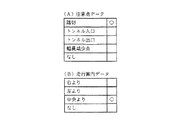
図2〜図4は、図1に示した本発明に係る情報記憶装置3に格納された主要なデータファイルの構成例を示している。図2(A)は経路算出手段により経路を算出し経路案内を行うために必要なデータが格納された案内道路データファイルを示し、道路数nのそれぞれに対して、道路番号、長さ、道路属性データ、形状データのアドレス、サイズおよび案内データのアドレス、サイズの各データからなる。前記道路番号は、分岐点間の道路毎に方向(往路、復路)別に設定されている。道路案内補助情報デーとしての前記道路属性データは、図3(A)に示すように、その道路が高架か、高架の横か、地下道か、地下道の横か、車線数の情報、分岐データ(分岐の有無のフラグ)、ランプデータ(ランプか否かのフラグ)、ロータリーデータ(ロータリー分岐か否かのフラグ)である。前記形状データは、図2(B)に示すように、各道路を複数のノード(節)で分割したとき、ノード数mのそれぞれに対して東経、北緯からなる座標データを有している。
【0021】
前記案内データは、図2(C)に示すように、交差点(または分岐点)名称、注意点データ、道路名称データ、道路名称音声データのアドレス、サイズおよび行き先データのアドレス、サイズの各データからなる。前記注意点データは、図4(A)に示すように、踏切か、トンネル入口か、トンネル出口か、幅員減少点か、注意点無し等の情報を示すデータで、分岐点以外の踏切、トンネル等において運転者に注意を促すためのデータである。前記道路名称データは、図3(B)に示すように、高速道路、都市高速道路、有料道路、一般道(国道、県道、その他)の道路種別の情報と、高速道路、都市高速道路、有料道路について本線か取付道かを示す情報を示すデータで、道路種別データと、さらに各道路種別毎での個別番号データである種別内番号から構成される。
【0022】
前記行き先データは、図2(D)に示すように行き先道路番号、行き先名称、行き先名称音声データのアドレス、サイズおよび行き先方向データ、走行案内データからなる。前記行き先名称は、方面名称も含んでいる。また、行き先方向データは、図2(E)に示すように、無効(行き先方向データを使用しない)、不要(案内を要しない)、直進、右方向、斜め右方向、右に戻る方向、左方向、斜め左方向、左に戻る方向の情報を示すデータである。前記走行案内データは、図4(B)に示すように、車線が複数ある場合どの車線を走行すべきかを案内するためのデータを格納したもので、右よりか、左よりか、中央よりか、無しかの情報を示すデータである。
【0023】
なお、図2のデータ構造では、道路データに交差点に関する情報を格納しているが、図5に示すように、道路データとは別に交差点データを持たせ、信号機の有無、横断歩道データ、分岐点特徴物データ、交差点に進入する道路データ、交差点から出る道路データ、ランドマークデータ等の情報を格納してもよい。ただし、道路データに接続情報を持たせた方が、ある道路からある道路は進入不可である等のデータを持たせ易く、データ量が少なくてすむ。
【0024】
図6は、音声案内するときの案内フレーズデータの例を示し、案内文を距離フレーズ、方向フレーズ、特徴フレーズ毎に分割し、案内音声データを出力する場合には、各フレーズを組み合わせて、例えば「まもなく右折です」というように作成し、設定された案内分岐点で出力する。本発明においては、後述するように案内分岐点に入る道路、出る道路のすべてについての道路情報を取得し、方向案内上の分類エリアに対して予め、直進(ストレート)、僅か右(左)方向(スライトライト(レフト)ターン)、右まがり(ライトベア)、左まがり(レフトベア)、道なり(キープ)、右道なり(キープライト)、左道なり(キープレフト)、フォーク、急右折(シャープライトターン)、急左折(シャープレフトターン)等のフレーズデータを設定しておき、これを案内分岐点の実情に応じて適宜選択してきめ細かい方向案内を行うようにしている。
図7は方向案内上の分類エリアと方向案内フレーズの対応の例を説明する図で、図7(a)では、案内分岐点に入る道路に対する角度でエリア1〜エリア6に分類し、エリア1,2はシャープターンエリア、エリア3,4はターンエリア、エリア5,6はベアエリアとした例である。そして、このエリア1〜6に対して、図7(b)に示すように、各方向案内フレーズを対応させ、このテーブルを情報記憶装置に記憶させておくようにしている。
【0025】
次に、本発明の車両用ナビゲーション装置の処理の流れについて説明する。図8は本発明に係る車両用ナビゲーション装置のシステム全体の流れを説明するためのフロー図である。
【0026】
中央処理装置4のCPU51により経路案内システムのプログラムが起動されると、現在位置検出装置2により現在位置を検出して現在位置を中心としてその周辺地図を表示すると共に、現在位置の名称等を表示する(ステップS1)。次に、地名や施設名称等の目標名、電話番号や住所、登録地点等を用いて目的地を設定し(ステップS2)、現在位置から目的地までの経路探索を行う(ステップS3)。経路が決まると、現在位置検出装置2による現在位置追跡を行いながら、目的地に到着するまで経路案内・表示を繰り返し行う(ステップS4)。目的地に到着する前に寄り道設定の入力があった場合には、探索エリアを設定してその探索エリアでの再探索を行い、同様に目的地に到着するまで経路案内を繰り返し行う。
本発明は、上記ステップS4の経路案内・表示において、ロータリー分岐での経路案内を精度よく行うものである。
【0027】
図9はロータリー分岐の道路取得を説明する図である。ロータリーは一方向の道路で、図9の例では時計方向に一方向である。
ロータリー分岐の場合、それに入る道路とそれから出る道路及びその間に存在する道路(リンク)を取得する。その方法として、ロータリーを形成する道路は、図3(A)に示すようにその属性をもっていることから、経路データ上の道路を先送りしながら道路属性を参照することによって取得できる。例えば、図9に示すロータリー分岐において、経路はa−b−d−eとし、ロータリー属性を持つ道路(リンク)がb−d−e−f−hとすると、道路aはロータリー属性を持たないから入る道路、bはロータリー属性を持っているから先送りし、cはロータリー属性を持っていないから出る道路、dはロータリー属性を持っているから先送りし、eはロータリー属性をもっていないから出る道路とする。結局、経路a−b−d−eにおいて、入る道路はa、出る道路はc、e、その間の道路(リンク)はb、dとして取得することができる。
【0028】
図10(a)はロータリーに入る道路と出る道路の角度差を説明する図で、入る道路R1 の延長線と出る道路R2 の延長線との交叉角aで表される。
また、図10(b)は取付け位置の角度を説明する図で、入る道路R1 の取付け位置(ロータリーとの接続点P)の角度は、道路R1 の終点(位置P)がロータリーの中心にくるように道路R1 を平行移動してR1 ′としたとき、出る道路R2 の取付け位置とロータリーの中心とを結ぶ線と道路R1 ′とのなす角で表される。
【0029】
次に、ロータリーの左右判定をするために用いる入る道路から出る道路までの角度変位の取得について図11により説明する。
図11において、ロータリーはリンク1〜6から構成され、リンク1に対して角度aで入り、リンク4から角度e1で出るとし、時計回りの角度を負、反時計回りの角度を正とすると、入る道路に対する出る道路の角度変位(差)は、
角度変位=aーbーcーd+e1
として求められる。
【0030】
図12はロータリーの方向判定の処理フローを説明する図である。
ステップ11は、対面通行のUターン判定処理であり、その処理フローは図13に示す通りである。
対面通行のUターン判定は、入る道路とき出る道路が同じ道路か否かを判断し、同じ道路であったら、Uターンとして判断する。対面通行のUターン判定の例を図12に示す。
【0031】
入る道路、出る道路がそれぞれ対面通行のとき、往、復で道路番号は正、負反転しているので、入る道路番号に(−1)を掛けた結果が出る道路に等しければUターンと判定する処理である。図13に示すように、入る道路の番号と出る道路番号の正負が逆か否か判定し(ステップ21)、正負が逆であればUターン案内を行い(ステップ22)、正負が逆でなければ処理は終了する。
【0032】
ステップ12は直進の判定処理であり、その処理フローは図14に示す通りである。
図14において、入る道路と出る道路の角度差(絶対値)が30°以内か否か判定し(ステップ31)、30°以内であれば直進としてその案内をする(ステップ34)。入る道路と出る道路の角度差が30°より大きい場合、45°以内か否か判定し(ステップ32)、45°以内であれば取付け位置の角度が30°以内か否か判定し(ステップ33)、30°以内であれば直進と判定し(ステップ35)、直進案内をする。入る道路と出る道路の角度差が45°より大きいか、あるいは角度差が45°以内であっても、取付け位置の角度が30°より大きい場合には、処理は終了する。ロータリーの場合、入る道路と出る道路の角度差だけでなく、入る道路と出る道路とのロータリーの接続点の相対位置関係により方向感覚が大きく異なる。そこで、入る道路と出る道路との角度が45°以内で、かつ取付け位置の角度が30°以内の場合は直進と判定している。
【0033】
ステップ13は一方通行のUターン判定処理であり、一方通行のUターンの例を図15に、処理フローを図16に示す。
図15において、道路aは対面通行道路であり、道路番号は正負は逆である。道路aに接続していてロータリー分岐に入る道路bと、ロータリー分岐から出て道路aに接続する道路cとは一方通行道路であり、名称が等しく、かつ隣あっている。そして、案内経路が矢印で示すように、道路a→道路b→ロータリー(時計方向回り)→道路c→道路aとし、道路aにおいて方向案内をする場合を説明する。
図16の処理フローにおいて、入る道路(図15の道路b)と出る道路(図15の道路c)の角度差が150°以上210°以下か否か判定し(ステップ41)、この範囲にあれば入る道路と出る道路の名称が等しいか否か判定する(ステップ42)。道路bとcは名称が等しいので、ロータリーの前後の道路(道路aの往路と復路)が対面通行であり、道路番号が等しいか否か判定する(ステップ43)。道路aの往路と復路は道路番号は等しいので、さらにロータリーの前後の道路が一方通行であり、入る道路と出る道路が隣あっているか否か判定する(ステップ44)、道路bとcはこれらの条件を満たすので、道路aにおいて一方通行のUターン案内をする(ステップ45)。各ステップでの条件が満たされない場合は処理が終了する。
【0034】
リンク(道路)が、上下線別々にデジタイズされたものかどうしの情報をデータベースにもたせ、入る道路と出る道路の両方が、ロータリーを逆方向に回る方向で近接して出る道路が存在する場合、Uターンと判定する。また、入る道路、出る道路のいずれか、または両方が一方通行道路で、この条件を満たさないものは、Uターンと判断しない。
【0035】
ステップ14はロータリーの左右判定の処理であり、その処理フローは図17に示す通りである。
図17において、リンクのトータル角度差が−150°(反時計回りを正、時計回りを負とする)未満か否か判定し(ステップ51)、−150°より大きい場合は、右に戻る方向と判断する(ステップ57)。リンクのトータル角度差が−150°未満、かつ0°未満の場合は右折と判断し(ステップ54)、リンクのトータル角度差が0°未満でなく(角度が正)、150°未満か否か判定し(ステップ53)、150°より大きいとき左に戻る方向と判断し(ステップ56)、150°未満のとき左折と判断する(ステップ55)。この結果、図18のように判定が行われ、対応する案内が行われることになる。
【図面の簡単な説明】
【図1】 本発明に係るナビゲーション装置の一例を示す図である。
【図2】 本発明に係る主要なデータファイルの構成例を示す図である。
【図3】 本発明に係る主要なデータファイルの構成例を示す図である。
【図4】 本発明に係る主要なデータファイルの構成例を示す図である。
【図5】 交差点データの例を示す図である。
【図6】 案内フレーズデータの例を示す図である。
【図7】 案内交差点の道路の退出エリアと方向案内フレーズを説明する図である。
【図8】 システム全体の流れを説明するためのフロー図である。
【図9】 ロータリー分岐における道路取得を説明する図である。
【図10】 ロータリーに入る道路と出る道路の角度差、取付け位置の角度を説明する図である。
【図11】 ロータリーに入る道路と出る道路までの角度変位を説明する図である。
【図12】 ロータリーの方向判定の処理フローを説明する図である。
【図13】 対面通行のUターン判定処理を説明する図である。
【図14】 直進判定処理フローを説明する図である。
【図15】 一方通行のUターン判定を行う場合の例を示す図である。
【図16】 一方通行のUターン判定処理フローを示す図である。
【図17】 左右判定処理フローを説明する図である。
【図18】 左右判定処理を説明する図である。
【符号の説明】
1…入出力装置、2…現在位置検出装置、3…情報記憶装置、4…中央処理装置、11…タッチスイッチ、12…ディスプレイ、13…プリンタ、16…スピーカ、21…GPS受信装置、22…ビーコン受信装置、23…データ送受信装置、40…CPU、41…フラッシュメモリ、42…ROM、43…RAM、44…画像メモリ、45…画像プロセッサ、46…音声プロセッサ、47…通信インタフェイス、48…センサ入力インタフェイス、49…時計[0001]
[Industrial application fields]
The present invention relates to a vehicle navigation apparatus and a storage medium that perform voice guidance at a road junction.
[0002]
[Prior art]
Conventionally, various route guidance devices for smoothly driving on unguided roads have been proposed, and by inputting a destination, a road to be traveled to that destination is guided. There is a route guidance device to do. In this route guidance device, when there is a rotary on the route, guidance is performed by determining the direction from the angle of the road entering and exiting the rotary and the attachment position (connection position between the rotary and the road).
[0003]
[Problems to be solved by the invention]
However, the conventional device does not use only the information of the road entering and exiting the rotary and the information of the installation position, and it is difficult to accurately determine the direction when passing through the rotary, In particular, the determination of the U-turn direction was extremely difficult.
[0004]
An object of the present invention is to provide a vehicle navigation device and a storage medium capable of providing easy-to-understand and accurate direction guidance when there is a rotary branch on the route. .
[0005]
The present invention includes a current position detecting means for calculating the current position of the vehicle,
An input means for inputting information necessary for calculating a route;
Output means for outputting information for route guidance;
Area information for direction guidance of the road coming out from the guidance branch point,
Information storage means storing data necessary for performing route guidance including direction guidance phrase data corresponding to each area;
Route calculation means for calculating a route based on information input by the input means;
Route information storage means for storing information of the route calculated by the route calculation means;
Based on the route calculated by the route calculation means and the current position detected by the current position detection means, the guidance control means for outputting the guidance information of the next guidance branch point to the output means,
The guidance control means determines a U-turn and performs a U-turn guidance on the condition that the road entering and exiting the rotary branch on the route stored in the route information storage means is the same road in face-to-face traffic It is characterized by.
[0006]
Further, the present invention provides a current position detecting means for calculating the current position of the vehicle,
An input means for inputting information necessary for calculating a route;
Output means for outputting information for route guidance;
Area information for direction guidance of the road coming out from the guidance branch point,
Information storage means storing data necessary for performing route guidance including direction guidance phrase data corresponding to each area;
Route calculation means for calculating a route based on information input by the input means;
Route information storage means for storing information of the route calculated by the route calculation means;
Based on the route calculated by the route calculation means and the current position detected by the current position detection means, the guidance control means for outputting the guidance information of the next guidance branch point to the output means,
The guidance control means is on condition that the angle difference between the road entering and exiting the rotary branch on the route stored in the route information storage means is within a predetermined range, and the entering road and the exiting road are adjacent to each other. In addition, it is characterized by determining a U-turn and performing U-turn guidance .
[0007]
Further, the present invention is a storage medium having a built-in program for searching for a route from a starting point or a current location to a destination, and performing guidance along the searched route.
Search for guidance points on the route,
Obtain the angle between the road entering and exiting the rotary branch on the route, the installation position information, and the information on the change angle of each link constituting the rotary,
A program for determining whether or not it is a U-turn based on the acquired name information of the road entering and exiting the rotary branch and the road condition before and after the road is installed is incorporated.
[0008]
[Operation and effect of the invention]
The present invention determines the direction from the road entering the roundabout, the angle of the road going out, the installation position, the name, the change angle of each link constituting the rotary, the information on the road before and after the road to enter and the like, etc. The direction guidance can be performed by accurately determining the U-turn direction, the left / right determination, and the like.
[0009]
DETAILED DESCRIPTION OF THE INVENTION
Embodiments of the present invention will be described below with reference to the drawings.
FIG. 1 is a diagram showing an example of a navigation apparatus according to the present invention. As shown in FIG. 1, the navigation apparatus according to the present invention includes an input /
[0010]
The input /
[0011]
Here, a voice recognition device for enabling voice input and a recording card reading device for reading data recorded on an IC card or a magnetic card may be added. In addition, an information center that accumulates data necessary for navigation and provides information via a communication line at the request of the driver, or a notebook electronic device that stores driver-specific data such as map data and destination data in advance. A data communication device for exchanging data with an information source such as a device can also be added.
[0012]
The
[0013]
The
[0014]
The current position detecting means 2 obtains information using a
[0015]
The
[0016]
The
[0017]
Note that a program for performing the above-described update processing may be stored in an external storage device.
The program according to the present invention and other programs for executing navigation may all be stored in a CD-ROM which is an external storage medium, or a part or all of these programs may be stored in the
[0018]
Various navigation functions are realized by inputting data and programs stored in the external storage medium as external signals to the central processing unit of the navigation apparatus main body and performing arithmetic processing.
[0019]
The navigation device according to the present invention stores a relatively large-
[0020]
2 to 4 show configuration examples of main data files stored in the
[0021]
As shown in FIG. 2 (C), the guidance data includes intersection (or branch point) name, attention point data, road name data, road name voice data address, size and destination data address, and size data. Become. As shown in FIG. 4A, the caution point data is data indicating information such as level crossings, tunnel entrances, tunnel exits, width reduction points, no points of caution, etc. This is data for urging the driver to pay attention in such situations. As shown in FIG. 3B, the road name data includes road type information such as highways, urban highways, toll roads, and general roads (national roads, prefectural roads, etc.), highways, urban highways, and tolls. Data indicating information indicating whether a road is a main line or an attachment road, and is composed of road type data and an intra-class number that is individual number data for each road type.
[0022]
As shown in FIG. 2 (D), the destination data includes a destination road number, a destination name, an address of destination name voice data, a size and destination direction data, and travel guidance data. The destination name includes a direction name. As shown in FIG. 2E, the destination direction data is invalid (no destination direction data is used), unnecessary (no guidance is required), straight ahead, right direction, diagonal right direction, right return direction, left This is data indicating information on the direction, the diagonally left direction, and the direction returning to the left. As shown in FIG. 4 (B), the travel guidance data stores data for guiding which lane to travel when there are a plurality of lanes, from the right, from the left, from the center. This is data indicating information on whether there is none.
[0023]
In the data structure of FIG. 2, information about the intersection is stored in the road data. However, as shown in FIG. 5, the intersection data is provided separately from the road data, the presence / absence of traffic lights, crosswalk data, branch points Information such as feature object data, road data entering an intersection, road data coming from an intersection, landmark data, and the like may be stored. However, if the road data has connection information, it is easier to have data such as that a road from a certain road cannot enter, and the amount of data can be reduced.
[0024]
FIG. 6 shows an example of guidance phrase data when voice guidance is performed. When a guidance sentence is divided into distance phrases, direction phrases, and characteristic phrases, and guidance voice data is output, the phrases are combined, for example, Created as “Soon to turn right” and output at the set guide branch point. In the present invention, as described later, road information about all roads entering and exiting the guidance branch point is acquired, and straight ahead (straight), slightly right (left) direction in advance with respect to the classification area on the direction guidance (Sright right (left) turn), right turn (right bear), left turn (left bear), road (keep), right road (keep right), left road (keep left), fork, sharp right turn (sharp right) Phrase data such as (turn) and sudden left turn (sharp left turn) is set, and this is selected as appropriate according to the actual situation of the guidance branch point, so that detailed direction guidance is performed.
FIG. 7 is a diagram for explaining an example of the correspondence between the classification area on the direction guidance and the direction guidance phrase. In FIG. 7A, the
[0025]
Next, a processing flow of the vehicle navigation device of the present invention will be described. FIG. 8 is a flowchart for explaining the flow of the entire system of the vehicle navigation apparatus according to the present invention.
[0026]
When the route guidance system program is started by the
The present invention accurately performs route guidance at the rotary branch in the route guidance / display in step S4.
[0027]
FIG. 9 is a diagram for explaining road acquisition of a rotary branch. The roundabout is a one-way road, and in the example of FIG.
In the case of a rotary branch, a road that enters the road, a road that leaves the road, and a road (link) existing between the roads are acquired. As a method, the roads forming the roundabout have the attribute as shown in FIG. 3A, and can be acquired by referring to the road attribute while deferring the road on the route data. For example, in the rotary branch shown in FIG. 9, if the route is ab-d-e and the road (link) having the rotary attribute is b-d-e-h, the road a does not have the rotary attribute. The road entering from, b is postponed because it has the rotary attribute, c is the road leaving because it does not have the rotary attribute, d is postponed because it has the rotary attribute, e is the road leaving because it does not have the rotary attribute To do. Eventually, in the route ab-d-e, the incoming road can be acquired as a, the outgoing road can be acquired as c, e, and the road (link) between them can be acquired as b, d.
[0028]
FIG. 10A is a diagram for explaining the angle difference between the road entering and exiting the roundabout, and is represented by the intersection angle a between the extension line of the entering road R 1 and the extension line of the exiting road R 2 .
FIG. 10B is a diagram for explaining the angle of the attachment position. The angle of the attachment position of the road R 1 (the connection point P with the rotary) is the end point (position P) of the road R 1 is the center of the rotary. When the road R 1 is translated to R 1 ′ so as to come to the road, the road R 1 ′ is represented by an angle formed by a line connecting the mounting position of the road R 2 to be exited and the center of the rotary.
[0029]
Next, acquisition of the angular displacement from the entering road to the exiting road used for determining the right and left of the rotary will be described with reference to FIG.
In FIG. 11, the rotary is composed of
Angular displacement = abcd + e1
As required.
[0030]
FIG. 12 is a diagram for explaining the processing flow of the rotary direction determination.
In the U-turn determination for face-to-face traffic, it is determined whether or not the road to be entered is the same road, and if it is the same road, it is determined as a U-turn. An example of U-turn determination for face-to-face traffic is shown in FIG.
[0031]
When the entering and exiting roads are facing each other, the road numbers are reversed positively and negatively in the forward and backward directions, so if the result of multiplying the incoming road number by (-1) is equal to the road coming out, it is determined as a U-turn It is processing to do. As shown in FIG. 13, it is determined whether the number of the road to enter and the number of the road to go out are reversed (step 21). If the sign is reversed, a U-turn guidance is provided (step 22), and the sign must be reversed. If so, the process ends.
[0032]
In FIG. 14, it is determined whether or not the angle difference (absolute value) between the entering road and the exiting road is within 30 ° (step 31). If the angle difference between the incoming road and the outgoing road is greater than 30 °, it is determined whether it is within 45 ° (step 32), and if it is within 45 °, it is determined whether the angle of the mounting position is within 30 ° (step 33). If the angle is within 30 °, it is determined that the vehicle is traveling straight (step 35), and the vehicle travels straight. If the angle difference between the incoming road and the outgoing road is greater than 45 °, or even if the angle difference is within 45 °, the process ends if the angle of the attachment position is greater than 30 °. In the case of a roundabout, the sense of direction varies greatly depending not only on the angle difference between the incoming road and the outgoing road, but also on the relative positional relationship of the rotary connection points between the incoming road and the outgoing road. Therefore, when the angle between the entering road and the exiting road is within 45 ° and the angle of the mounting position is within 30 °, it is determined that the vehicle travels straight.
[0033]
Step 13 is a one-way U-turn determination process. FIG. 15 shows an example of a one-way U-turn, and FIG. 16 shows a processing flow.
In FIG. 15, the road a is a two-way road, and the road number is opposite in sign. A road b that is connected to the road a and enters the rotary branch and a road c that exits the rotary branch and connects to the road a are one-way roads that have the same name and are adjacent to each other. Then, as shown by the arrow in the guide route, the road a → road b → rotary (clockwise) → road c → road a will be described.
In the processing flow of FIG. 16, it is determined whether or not the angle difference between the entering road (road b in FIG. 15) and the exiting road (road c in FIG. 15) is not less than 150 ° and not more than 210 ° (step 41). Then, it is determined whether or not the names of the road to enter and the road to exit are equal (step 42). Since the names of the roads b and c are the same, it is determined whether the roads before and after the roundabout (the forward path and the return path of the road a) are face-to-face traffic and the road numbers are equal (step 43). Since the road number is the same for the forward path and the return path of road a, it is further determined whether the roads before and after the roundabout are one-way, and the road to enter and the road to exit are next to each other (step 44). Therefore, a one-way U-turn guidance is provided on the road a (step 45). If the conditions at each step are not satisfied, the process ends.
[0034]
If the links (roads) are digitized separately for the top and bottom lines in the database, and there are roads that come close together in the direction where both the incoming and outgoing roads go around the roundabout, Judge as U-turn. Also, any one or both of the entering road and the exiting road are one-way roads that do not satisfy this condition are not judged as U-turns.
[0035]
Step 14 is a rotary left / right determination process, and the process flow is as shown in FIG.
In FIG. 17, it is determined whether or not the total angle difference of the link is less than −150 ° (counterclockwise is positive and clockwise is negative) (step 51). (Step 57). If the total angle difference of the link is less than −150 ° and less than 0 °, it is determined that the turn is right (step 54), and the total angle difference of the link is not less than 0 ° (the angle is positive) and is less than 150 °. A determination is made (step 53), and when it is larger than 150 °, it is determined that the direction returns to the left (step 56). As a result, the determination is made as shown in FIG. 18, and the corresponding guidance is performed.
[Brief description of the drawings]
FIG. 1 is a diagram showing an example of a navigation apparatus according to the present invention.
FIG. 2 is a diagram showing a configuration example of main data files according to the present invention.
FIG. 3 is a diagram showing a configuration example of main data files according to the present invention.
FIG. 4 is a diagram showing a configuration example of main data files according to the present invention.
FIG. 5 is a diagram illustrating an example of intersection data.
FIG. 6 is a diagram illustrating an example of guidance phrase data.
FIG. 7 is a diagram for explaining a leaving area and a direction guidance phrase of a road at a guidance intersection.
FIG. 8 is a flowchart for explaining the flow of the entire system.
FIG. 9 is a diagram for explaining road acquisition in a rotary branch.
FIG. 10 is a diagram for explaining an angle difference between a road entering and exiting a roundabout and an angle of an attachment position.
FIG. 11 is a diagram illustrating angular displacement between a road entering and exiting a roundabout.
FIG. 12 is a diagram illustrating a processing flow for determining the direction of a rotary.
FIG. 13 is a diagram illustrating a U-turn determination process for face-to-face traffic.
FIG. 14 is a diagram illustrating a straight-ahead determination processing flow.
FIG. 15 is a diagram illustrating an example in a case where a one-way U-turn determination is performed.
FIG. 16 is a diagram showing a one-way U-turn determination process flow;
FIG. 17 is a diagram illustrating a left / right determination processing flow.
FIG. 18 is a diagram illustrating a left / right determination process.
[Explanation of symbols]
DESCRIPTION OF
Claims (3)
経路を算出するために必要な情報を入力する入力手段と、
経路案内のための情報を出力する出力手段と、
案内分岐点から出る道路の方向案内のためのエリア情報と、
各エリアに対応する方向案内フレーズデータを含む経路案内を行うために必要なデータを格納した情報記憶手段と、
前記入力手段により入力された情報に基づき経路を算出する経路算出手段と、
該経路算出手段により算出された経路の情報を記憶する経路情報記憶手段と、
前記経路算出手段により算出された経路と前記現在位置検出手段により検出された現在位置とに基づいて、次の案内分岐点の案内情報を前記出力手段に出力する案内制御手段とを備え、
前記案内制御手段は、前記経路情報記憶手段に記憶された経路上のロータリー分岐に入る道路と出る道路が対面通行で同じ道路であることを条件に、Uターンと判定しUターン案内を行うことを特徴とする車両用ナビゲーション装置。Current position detecting means for calculating the current position of the vehicle;
An input means for inputting information necessary for calculating a route;
Output means for outputting information for route guidance;
Area information for direction guidance of the road coming out from the guidance branch point,
Information storage means storing data necessary for performing route guidance including direction guidance phrase data corresponding to each area;
Route calculation means for calculating a route based on information input by the input means;
Route information storage means for storing information of the route calculated by the route calculation means;
Based on the route calculated by the route calculation means and the current position detected by the current position detection means, the guidance control means for outputting the guidance information of the next guidance branch point to the output means,
The guidance control means determines a U-turn and performs a U-turn guidance on the condition that the road entering and exiting the rotary branch on the route stored in the route information storage means is the same road in face-to-face traffic A vehicle navigation apparatus characterized by the above.
経路を算出するために必要な情報を入力する入力手段と、
経路案内のための情報を出力する出力手段と、
案内分岐点から出る道路の方向案内のためのエリア情報と、
各エリアに対応する方向案内フレーズデータを含む経路案内を行うために必要なデータを格納した情報記憶手段と、
前記入力手段により入力された情報に基づき経路を算出する経路算出手段と、
該経路算出手段により算出された経路の情報を記憶する経路情報記憶手段と、
前記経路算出手段により算出された経路と前記現在位置検出手段により検出された現在位置とに基づいて、次の案内分岐点の案内情報を前記出力手段に出力する案内制御手段とを備え、
前記案内制御手段は、前記経路情報記憶手段に記憶された経路上のロータリー分岐に入る道路と出る道路の角度差が所定範囲内で、かつ入る道路と出る道路とが隣あっていることを条件に、Uターンと判定しUターン案内を行うことを特徴とする車両用ナビゲーション装置。Current position detecting means for calculating the current position of the vehicle;
An input means for inputting information necessary for calculating a route;
Output means for outputting information for route guidance;
Area information for direction guidance of the road coming out from the guidance branch point,
Information storage means storing data necessary for performing route guidance including direction guidance phrase data corresponding to each area;
Route calculation means for calculating a route based on information input by the input means;
Route information storage means for storing information of the route calculated by the route calculation means;
Based on the route calculated by the route calculation means and the current position detected by the current position detection means, the guidance control means for outputting the guidance information of the next guidance branch point to the output means,
The guidance control means is on condition that the angle difference between the road entering and exiting the rotary branch on the route stored in the route information storage means is within a predetermined range, and the entering road and the exiting road are adjacent to each other. A vehicle navigation device characterized by determining a U-turn and performing a U-turn guidance .
経路上の案内分岐点を検索し、
経路上のロータリー分岐に入る道路と出る道路とのなす角度、及び取付け位置情報、ロータリーを構成する各リンクの変化角の情報を取得し、
取得したロータリー分岐に入る道路と出る道路の名称情報、道路の取付けの前後の道路状態に基づいてUターンか否かを判定するプログラムを内蔵したことを特徴とする記憶媒体。In a storage medium with a built-in program that searches the route from the starting point or the current location to the destination, and guides along the searched route,
Search for guidance points on the route,
Obtain the angle between the road entering and exiting the rotary branch on the route, the installation position information, and the information on the change angle of each link constituting the rotary,
A storage medium having a built-in program for determining whether or not it is a U-turn based on acquired name information of a road entering and exiting a rotary branch and a road condition before and after the road is attached.
Priority Applications (3)
| Application Number | Priority Date | Filing Date | Title |
|---|---|---|---|
| JP22726297A JP3719315B2 (en) | 1997-08-08 | 1997-08-08 | Vehicle navigation device and storage medium |
| US09/131,325 US6108604A (en) | 1997-08-08 | 1998-08-07 | Vehicular navigation system and storage medium |
| DE19836156A DE19836156B4 (en) | 1997-08-08 | 1998-08-10 | Vehicle navigation system and storage medium |
Applications Claiming Priority (1)
| Application Number | Priority Date | Filing Date | Title |
|---|---|---|---|
| JP22726297A JP3719315B2 (en) | 1997-08-08 | 1997-08-08 | Vehicle navigation device and storage medium |
Publications (2)
| Publication Number | Publication Date |
|---|---|
| JPH1151684A JPH1151684A (en) | 1999-02-26 |
| JP3719315B2 true JP3719315B2 (en) | 2005-11-24 |
Family
ID=16858073
Family Applications (1)
| Application Number | Title | Priority Date | Filing Date |
|---|---|---|---|
| JP22726297A Expired - Fee Related JP3719315B2 (en) | 1997-08-08 | 1997-08-08 | Vehicle navigation device and storage medium |
Country Status (3)
| Country | Link |
|---|---|
| US (1) | US6108604A (en) |
| JP (1) | JP3719315B2 (en) |
| DE (1) | DE19836156B4 (en) |
Families Citing this family (48)
| Publication number | Priority date | Publication date | Assignee | Title |
|---|---|---|---|---|
| JP3525789B2 (en) * | 1999-03-18 | 2004-05-10 | 株式会社デンソー | Car navigation system |
| JP3994365B2 (en) * | 1999-09-03 | 2007-10-17 | アイシン・エィ・ダブリュ株式会社 | Navigation device and storage medium |
| US6415226B1 (en) * | 1999-12-20 | 2002-07-02 | Navigation Technologies Corp. | Method and system for providing safe routes using a navigation system |
| US6397145B1 (en) * | 2000-03-06 | 2002-05-28 | Magellan Dis, Inc. | Navigation system with complex maneuver instruction |
| US6654682B2 (en) * | 2000-03-23 | 2003-11-25 | Siemens Transportation Systems, Inc. | Transit planning system |
| US6292745B1 (en) * | 2000-07-24 | 2001-09-18 | Navigation Technologies Corp. | Method and system for forming a database of geographic data for distribution to navigation system units |
| JP4094246B2 (en) * | 2001-05-10 | 2008-06-04 | アルパイン株式会社 | Car navigation system |
| US6625538B2 (en) * | 2001-11-01 | 2003-09-23 | General Motors Corporation | Method and system for reducing maneuver proximity diameter for a waypoint navigation system |
| US6545637B1 (en) | 2001-12-20 | 2003-04-08 | Garmin, Ltd. | Systems and methods for a navigational device with improved route calculation capabilities |
| US6892135B1 (en) | 2001-12-21 | 2005-05-10 | Garmin Ltd. | Navigation system, method and device with automatic next turn page |
| US7277794B1 (en) | 2001-12-21 | 2007-10-02 | Garmin Ltd. | Guidance with feature accounting for insignificant roads |
| US6847890B1 (en) | 2001-12-21 | 2005-01-25 | Garmin Ltd. | Guidance with feature accounting for insignificant roads |
| US6873905B2 (en) * | 2002-03-19 | 2005-03-29 | Opnext Japan, Inc. | Communications type navigation device |
| JP2003269979A (en) * | 2002-03-19 | 2003-09-25 | Pioneer Electronic Corp | Route guide device and route guide method |
| JP3915646B2 (en) * | 2002-09-27 | 2007-05-16 | 株式会社デンソー | Map display device |
| KR100648342B1 (en) * | 2003-02-10 | 2006-11-23 | 엘지전자 주식회사 | Navigation system and its operation |
| TWI278602B (en) * | 2005-03-22 | 2007-04-11 | Denso Corp | Vehicular navigation system |
| JP4148232B2 (en) * | 2005-03-22 | 2008-09-10 | 株式会社デンソー | Route guidance device |
| WO2006109471A1 (en) * | 2005-03-31 | 2006-10-19 | Pioneer Corporation | Navigation system, method and program, and computer-readable recording medium |
| JP4555137B2 (en) * | 2005-04-08 | 2010-09-29 | クラリオン株式会社 | Current position calculation device |
| JP2007071601A (en) * | 2005-09-05 | 2007-03-22 | Denso Corp | Route guide device and program |
| US7590490B2 (en) * | 2006-01-09 | 2009-09-15 | Mitac International Corporation | Smart detour |
| US20070250515A1 (en) * | 2006-04-21 | 2007-10-25 | Lea David H | Method and system of securing content and destination of digital download via the internet |
| US7945386B2 (en) * | 2006-08-25 | 2011-05-17 | Mitac International Corporation | Rerouting in vehicle navigation systems |
| US20080139181A1 (en) * | 2006-12-08 | 2008-06-12 | Magellan Navigation, Inc. | Methods and apparatus for measuring the effectiveness of advertisements presented on a mobile navigation device |
| US7692655B2 (en) * | 2007-02-16 | 2010-04-06 | Mitac International Corporation | Apparatus and method of generating curved baseline for map labeling |
| US7783417B2 (en) * | 2007-03-09 | 2010-08-24 | Mitac International Corporation | Methods and apparatus for determining a route having an estimated minimum fuel usage for a vehicle |
| FR2913930B1 (en) * | 2007-03-20 | 2009-05-29 | Jean-Pierre Cado | "SYSTEM AND METHOD FOR OPERATING A DIRECTION CHANGE INDICATOR" |
| US8467962B2 (en) * | 2007-03-23 | 2013-06-18 | Mitsubishi Electric Corporation | Navigation system and lane information display method |
| US8078641B2 (en) * | 2007-04-25 | 2011-12-13 | Mitac International Corporation | Adjusting spatial operations based on map density |
| US7882102B2 (en) * | 2007-09-10 | 2011-02-01 | Mitac International Corporation | Nearest-neighbor geographic search |
| US8554475B2 (en) | 2007-10-01 | 2013-10-08 | Mitac International Corporation | Static and dynamic contours |
| US20090138190A1 (en) * | 2007-11-26 | 2009-05-28 | Magellan Navigation, Inc. | System and Method of Providing Traffic Data to a Mobile Device |
| US20090171584A1 (en) * | 2007-12-31 | 2009-07-02 | Magellan Navigation, Inc. | System and Method for Accessing a Navigation System |
| US20090182498A1 (en) * | 2008-01-11 | 2009-07-16 | Magellan Navigation, Inc. | Systems and Methods to Provide Navigational Assistance Using an Online Social Network |
| US8290703B2 (en) * | 2008-01-18 | 2012-10-16 | Mitac International Corporation | Method and apparatus for access point recording using a position device |
| US8498808B2 (en) * | 2008-01-18 | 2013-07-30 | Mitac International Corp. | Method and apparatus for hybrid routing using breadcrumb paths |
| US8700314B2 (en) * | 2008-01-18 | 2014-04-15 | Mitac International Corporation | Method and apparatus to search for local parking |
| JP4577379B2 (en) * | 2008-03-04 | 2010-11-10 | 株式会社デンソー | Navigation device |
| US20100035631A1 (en) * | 2008-08-07 | 2010-02-11 | Magellan Navigation, Inc. | Systems and Methods to Record and Present a Trip |
| US8249804B2 (en) * | 2008-08-20 | 2012-08-21 | Mitac International Corporation | Systems and methods for smart city search |
| US8219317B2 (en) * | 2008-09-22 | 2012-07-10 | Mitac International Corporation | Route navigation via a proximity point |
| JP5864130B2 (en) * | 2011-05-18 | 2016-02-17 | アルパイン株式会社 | Navigation device |
| DE102014015903B4 (en) * | 2014-10-29 | 2016-12-29 | Preh Car Connect Gmbh | Outputting a directional instruction with a navigation device |
| MX2019015359A (en) | 2017-06-26 | 2020-02-07 | Nissan Motor | Method for controlling direction indicator and device for controlling direction indicator. |
| CN111243313B (en) * | 2018-11-29 | 2022-07-26 | 沈阳美行科技股份有限公司 | Roundabout navigation method and device, terminal equipment and storage medium |
| CN111383460B (en) * | 2020-06-01 | 2020-09-18 | 浙江大华技术股份有限公司 | Vehicle state discrimination method and device and computer storage medium |
| CN115235494B (en) * | 2022-07-19 | 2024-08-23 | 南京四维智联科技有限公司 | Method, device, equipment and storage medium for guiding roundabout road section |
Family Cites Families (4)
| Publication number | Priority date | Publication date | Assignee | Title |
|---|---|---|---|---|
| US5177685A (en) * | 1990-08-09 | 1993-01-05 | Massachusetts Institute Of Technology | Automobile navigation system using real time spoken driving instructions |
| DE69217311T2 (en) * | 1991-09-25 | 1997-07-24 | Philips Electronics Nv | Device and method for map display in vehicle navigation |
| US5982301A (en) * | 1995-01-20 | 1999-11-09 | Mitsubishi Denki Kabushiki Kaisha | Navigation apparatus |
| US5729109A (en) * | 1995-07-19 | 1998-03-17 | Matsushita Electric Industrial Co., Ltd. | Navigation system and intersection guidance method |
-
1997
- 1997-08-08 JP JP22726297A patent/JP3719315B2/en not_active Expired - Fee Related
-
1998
- 1998-08-07 US US09/131,325 patent/US6108604A/en not_active Expired - Lifetime
- 1998-08-10 DE DE19836156A patent/DE19836156B4/en not_active Expired - Lifetime
Also Published As
| Publication number | Publication date |
|---|---|
| JPH1151684A (en) | 1999-02-26 |
| US6108604A (en) | 2000-08-22 |
| DE19836156A1 (en) | 1999-02-11 |
| DE19836156B4 (en) | 2007-10-04 |
Similar Documents
| Publication | Publication Date | Title |
|---|---|---|
| JP3719315B2 (en) | Vehicle navigation device and storage medium | |
| US6226590B1 (en) | Vehicular navigation system and storage medium | |
| JP3448134B2 (en) | Vehicle navigation system | |
| JP3994365B2 (en) | Navigation device and storage medium | |
| US20080021638A1 (en) | Navigation system | |
| JP4096180B2 (en) | NAVIGATION DEVICE, PROGRAM FOR THE DEVICE, AND RECORDING MEDIUM | |
| JPH1151681A (en) | Car navigation system and recording medium | |
| JP2001050767A (en) | Navigation device and memory medium | |
| JP2002107164A (en) | Navigator and its memory medium | |
| JP3891231B2 (en) | Vehicle navigation device | |
| JP3716898B2 (en) | Vehicle navigation device and storage medium | |
| JP3874052B2 (en) | NAVIGATION DEVICE AND STORAGE MEDIUM CONTAINING THE PROGRAM | |
| JP3596704B2 (en) | Vehicle navigation device and navigation method | |
| JP3409657B2 (en) | Vehicle navigation device and storage medium | |
| JP2924885B2 (en) | Vehicle navigation system | |
| JP3097513B2 (en) | Vehicle navigation device | |
| JPH10122890A (en) | Navigator for vehicle | |
| JP3760958B2 (en) | Navigation device | |
| JP4261967B2 (en) | Vehicle navigation apparatus, program for the apparatus, and recording medium | |
| JP3393443B2 (en) | Vehicle navigation device and storage medium | |
| JP2000046566A (en) | Map display device and storage medium | |
| JP3409656B2 (en) | Vehicle navigation device and storage medium | |
| JP3801358B2 (en) | Vehicle navigation apparatus and method | |
| JP2001272238A (en) | Navigation device and storage medium | |
| JP3341803B2 (en) | Vehicle navigation system |
Legal Events
| Date | Code | Title | Description |
|---|---|---|---|
| A977 | Report on retrieval |
Free format text: JAPANESE INTERMEDIATE CODE: A971007 Effective date: 20041115 |
|
| A131 | Notification of reasons for refusal |
Free format text: JAPANESE INTERMEDIATE CODE: A131 Effective date: 20041210 |
|
| A521 | Written amendment |
Free format text: JAPANESE INTERMEDIATE CODE: A523 Effective date: 20050208 |
|
| TRDD | Decision of grant or rejection written | ||
| A01 | Written decision to grant a patent or to grant a registration (utility model) |
Free format text: JAPANESE INTERMEDIATE CODE: A01 Effective date: 20050817 |
|
| A61 | First payment of annual fees (during grant procedure) |
Free format text: JAPANESE INTERMEDIATE CODE: A61 Effective date: 20050830 |
|
| R150 | Certificate of patent or registration of utility model |
Free format text: JAPANESE INTERMEDIATE CODE: R150 |
|
| FPAY | Renewal fee payment (event date is renewal date of database) |
Free format text: PAYMENT UNTIL: 20090916 Year of fee payment: 4 |
|
| FPAY | Renewal fee payment (event date is renewal date of database) |
Free format text: PAYMENT UNTIL: 20090916 Year of fee payment: 4 |
|
| FPAY | Renewal fee payment (event date is renewal date of database) |
Free format text: PAYMENT UNTIL: 20100916 Year of fee payment: 5 |
|
| FPAY | Renewal fee payment (event date is renewal date of database) |
Free format text: PAYMENT UNTIL: 20100916 Year of fee payment: 5 |
|
| FPAY | Renewal fee payment (event date is renewal date of database) |
Free format text: PAYMENT UNTIL: 20110916 Year of fee payment: 6 |
|
| FPAY | Renewal fee payment (event date is renewal date of database) |
Free format text: PAYMENT UNTIL: 20110916 Year of fee payment: 6 |
|
| FPAY | Renewal fee payment (event date is renewal date of database) |
Free format text: PAYMENT UNTIL: 20120916 Year of fee payment: 7 |
|
| FPAY | Renewal fee payment (event date is renewal date of database) |
Free format text: PAYMENT UNTIL: 20130916 Year of fee payment: 8 |
|
| FPAY | Renewal fee payment (event date is renewal date of database) |
Free format text: PAYMENT UNTIL: 20130916 Year of fee payment: 8 |
|
| FPAY | Renewal fee payment (event date is renewal date of database) |
Free format text: PAYMENT UNTIL: 20140916 Year of fee payment: 9 |
|
| LAPS | Cancellation because of no payment of annual fees |