JP2023021098A - Map construction method, device and storage medium - Google Patents
Map construction method, device and storage medium Download PDFInfo
- Publication number
- JP2023021098A JP2023021098A JP2022122263A JP2022122263A JP2023021098A JP 2023021098 A JP2023021098 A JP 2023021098A JP 2022122263 A JP2022122263 A JP 2022122263A JP 2022122263 A JP2022122263 A JP 2022122263A JP 2023021098 A JP2023021098 A JP 2023021098A
- Authority
- JP
- Japan
- Prior art keywords
- semantic
- pose
- constraint
- point cloud
- error function
- Prior art date
- Legal status (The legal status is an assumption and is not a legal conclusion. Google has not performed a legal analysis and makes no representation as to the accuracy of the status listed.)
- Pending
Links
Images


Classifications
-
- G—PHYSICS
- G01—MEASURING; TESTING
- G01C—MEASURING DISTANCES, LEVELS OR BEARINGS; SURVEYING; NAVIGATION; GYROSCOPIC INSTRUMENTS; PHOTOGRAMMETRY OR VIDEOGRAMMETRY
- G01C21/00—Navigation; Navigational instruments not provided for in groups G01C1/00 - G01C19/00
- G01C21/38—Electronic maps specially adapted for navigation; Updating thereof
- G01C21/3804—Creation or updating of map data
- G01C21/3807—Creation or updating of map data characterised by the type of data
- G01C21/3811—Point data, e.g. Point of Interest [POI]
-
- G—PHYSICS
- G01—MEASURING; TESTING
- G01C—MEASURING DISTANCES, LEVELS OR BEARINGS; SURVEYING; NAVIGATION; GYROSCOPIC INSTRUMENTS; PHOTOGRAMMETRY OR VIDEOGRAMMETRY
- G01C21/00—Navigation; Navigational instruments not provided for in groups G01C1/00 - G01C19/00
- G01C21/38—Electronic maps specially adapted for navigation; Updating thereof
- G01C21/3863—Structures of map data
- G01C21/3867—Geometry of map features, e.g. shape points, polygons or for simplified maps
-
- G—PHYSICS
- G06—COMPUTING OR CALCULATING; COUNTING
- G06T—IMAGE DATA PROCESSING OR GENERATION, IN GENERAL
- G06T7/00—Image analysis
- G06T7/10—Segmentation; Edge detection
- G06T7/11—Region-based segmentation
-
- G—PHYSICS
- G06—COMPUTING OR CALCULATING; COUNTING
- G06T—IMAGE DATA PROCESSING OR GENERATION, IN GENERAL
- G06T7/00—Image analysis
- G06T7/70—Determining position or orientation of objects or cameras
- G06T7/73—Determining position or orientation of objects or cameras using feature-based methods
- G06T7/74—Determining position or orientation of objects or cameras using feature-based methods involving reference images or patches
-
- G—PHYSICS
- G06—COMPUTING OR CALCULATING; COUNTING
- G06V—IMAGE OR VIDEO RECOGNITION OR UNDERSTANDING
- G06V10/00—Arrangements for image or video recognition or understanding
- G06V10/70—Arrangements for image or video recognition or understanding using pattern recognition or machine learning
- G06V10/762—Arrangements for image or video recognition or understanding using pattern recognition or machine learning using clustering, e.g. of similar faces in social networks
-
- G—PHYSICS
- G06—COMPUTING OR CALCULATING; COUNTING
- G06V—IMAGE OR VIDEO RECOGNITION OR UNDERSTANDING
- G06V20/00—Scenes; Scene-specific elements
- G06V20/50—Context or environment of the image
- G06V20/56—Context or environment of the image exterior to a vehicle by using sensors mounted on the vehicle
- G06V20/588—Recognition of the road, e.g. of lane markings; Recognition of the vehicle driving pattern in relation to the road
-
- G—PHYSICS
- G06—COMPUTING OR CALCULATING; COUNTING
- G06T—IMAGE DATA PROCESSING OR GENERATION, IN GENERAL
- G06T2207/00—Indexing scheme for image analysis or image enhancement
- G06T2207/10—Image acquisition modality
- G06T2207/10028—Range image; Depth image; 3D point clouds
-
- G—PHYSICS
- G06—COMPUTING OR CALCULATING; COUNTING
- G06T—IMAGE DATA PROCESSING OR GENERATION, IN GENERAL
- G06T2207/00—Indexing scheme for image analysis or image enhancement
- G06T2207/30—Subject of image; Context of image processing
- G06T2207/30248—Vehicle exterior or interior
- G06T2207/30252—Vehicle exterior; Vicinity of vehicle
- G06T2207/30256—Lane; Road marking
Landscapes
- Engineering & Computer Science (AREA)
- Physics & Mathematics (AREA)
- Radar, Positioning & Navigation (AREA)
- Remote Sensing (AREA)
- General Physics & Mathematics (AREA)
- Theoretical Computer Science (AREA)
- Computer Vision & Pattern Recognition (AREA)
- Automation & Control Theory (AREA)
- Multimedia (AREA)
- Geometry (AREA)
- Health & Medical Sciences (AREA)
- Artificial Intelligence (AREA)
- Computing Systems (AREA)
- Databases & Information Systems (AREA)
- Evolutionary Computation (AREA)
- General Health & Medical Sciences (AREA)
- Medical Informatics (AREA)
- Software Systems (AREA)
- Processing Or Creating Images (AREA)
- Image Analysis (AREA)
- Length Measuring Devices By Optical Means (AREA)
- Control Of Position, Course, Altitude, Or Attitude Of Moving Bodies (AREA)
Abstract
【課題】セマンティック結果と姿勢結果が相互制約関係を形成することができ、セマンティックマップと点群マップを迅速、かつ、正確に得ることができ、さらに、より精確な高精度マップを得ることができ、移動体の自律移動性能を向上させることに有利なマップ構築方法、装置及び記憶媒体を提供する。【解決手段】方法は、予め設定されたセンサによって収集されたセンサデータを取得するステップと、前記センサデータに基づいて移動体の姿勢制約関係及びセマンティックオブジェクトのセマンティック制約関係を確立するステップと、姿勢制約関係及びセマンティック制約関係に基づいて組合せ最適化求解を行い、セマンティックオブジェクトのセマンティック結果及び移動体の姿勢結果を決定するステップと、セマンティック結果及び姿勢結果に基づいてセマンティックマップ及び点群マップを構築するステップと、を含む。【選択図】図1[Problem] Semantic results and pose results can form a mutual constraint relationship, semantic maps and point cloud maps can be obtained quickly and accurately, and more accurate high-precision maps can be obtained. The present invention provides a map construction method, device, and storage medium that are advantageous in improving the autonomous movement performance of a mobile object. The method includes the steps of: acquiring sensor data collected by a preset sensor; establishing a posture constraint relationship of a moving object and a semantic constraint relationship of a semantic object based on the sensor data; Performing a combinatorial optimization solution based on the constraint relationship and the semantic constraint relationship to determine the semantic result of the semantic object and the pose result of the moving body, and constructing a semantic map and a point cloud map based on the semantic result and the pose result. and a step. [Selection diagram] Figure 1
Description
本発明の実施例は、高精度マップ技術分野に関し、特に、マップ構築方法、装置、デバイス及び記憶媒体に関する。 TECHNICAL FIELD Embodiments of the present invention relate to the field of high precision map technology, and more particularly to map building methods, apparatus, devices and storage media.
自動運転技術、インテリジェントロボット技術の発展に伴い、自動運転車両とインテリジェントロボットの正確な走行をいかに保証するかがホット点問題となっている。自動運転技術においては、一般的に、高精度マップ(High Definition Map)が適用され、高精度マップは、主に、点群マップとセマンティックマップとを含む。そのうち、点群マップは、空間位置情報を含む三次元(3-dimension、3D)点群であってもよく、主にレジストレーションに基づくオンライン位置特定に用いられ、セマンティックマップは、車線、道路ポール又は信号機などの道路情報を含むマップであってもよく、オンライン位置特定及び経路計画などに用いられてもよく、ここで、車線、道路ポール又は信号機などの交通要素がセマンティックオブジェクトと呼ばれることができる。 With the development of self-driving technology and intelligent robot technology, how to ensure the accurate driving of self-driving vehicles and intelligent robots has become a hot issue. In automatic driving technology, a high definition map is generally applied, and the high definition map mainly includes a point cloud map and a semantic map. Among them, the point cloud map can be a three-dimensional (3-dimension, 3D) point cloud containing spatial location information, mainly used for online localization based on registration, the semantic map is the lane, road pole Or it may be a map containing road information such as traffic lights, and may be used for online location and route planning, etc., where traffic elements such as lanes, road poles or traffic lights can be called semantic objects. .
現在、高精度の点群マップ及び車線マップを構築する方法は、主に2つあり、1つは、高精度の複合ナビゲーション装置を利用してリアルタイム姿勢を計算し、そして得られた姿勢に基づいて、レーザレーダの走査によって得られた点群を世界座標系に変換し、一定時間又は一定距離におけるデータを累積すれば高密度の点群マップを得ることができ、その後、点群マップにおける異なる物体の反射率の違いに基づいて、セマンティックマップを手動で描くことである。もう1つは、伝統的な位置特定とマップ作成の同時実行(Simultaneous Localization and Mapping、SLAM)方法により、姿勢推定及び疎な点群マップの構築を実現し、その上で二次元(2-dimension、2D)画像に対してセマンティックセグメンテーションを行って道路情報に関連する点を得、さらにセマンティックマップを構築することである。 At present, there are mainly two methods to build high-precision point cloud maps and lane maps. Then, the point cloud obtained by scanning the laser radar is converted to the world coordinate system, and a high-density point cloud map can be obtained by accumulating the data at a fixed time or a fixed distance. It is to manually draw a semantic map based on the difference in reflectance of objects. The other is to realize pose estimation and sparse point cloud map construction by traditional Simultaneous Localization and Mapping (SLAM) method, and then use two-dimensional (2-dimension , 2D) to perform semantic segmentation on the image to obtain points related to road information, and to build a semantic map.
しかしながら、従来の解決策では、車線を手動で描く方式は、コストが高く、かつ効率が低く、また、点群の反射率は、路面材質、湿度、及びレーザレーダ取り付け高さなどの外的要因による外乱を受けやすく、実際の道路シーンにおいて、点群反射率により全ての道路情報を正確に認識することは困難である。また、視覚的方法により直接取得されるのは2D情報であり、精度が低く、構築したセマンティックマップの誤差が大きい。このように、既存の高精度マップの構築方法は未だ不十分であり、改善が求められている。 However, in conventional solutions, the method of drawing lanes manually is costly and inefficient, and the reflectance of point cloud depends on external factors such as road surface material, humidity, and laser radar mounting height. It is difficult to accurately recognize all road information from the point cloud reflectance in an actual road scene. In addition, the visual method directly obtains 2D information, which has low accuracy and large errors in the constructed semantic map. Thus, existing methods for constructing high-precision maps are still inadequate, and improvements are required.
本発明の実施例は、既存の高精度マップの構築方法を最適化することができるマップ構築方法、装置、デバイス及び記憶媒体を提供する。 Embodiments of the present invention provide map building methods, apparatus, devices and storage media that can optimize existing high-precision map building methods.
第1の態様において、本発明の実施例は、マップ構築方法を提供し、前記方法は、
予め設定されたセンサによって収集されたセンサデータを取得するステップと、
前記センサデータに基づいて移動体の姿勢制約関係及びセマンティックオブジェクトのセマンティック制約関係を確立するステップと、
前記姿勢制約関係及び前記セマンティック制約関係に基づいて組合せ最適化求解を行い、前記セマンティックオブジェクトのセマンティック結果及び前記移動体の姿勢結果を決定するステップと、
前記セマンティック結果及び前記姿勢結果に基づいてセマンティックマップ及び点群マップを構築するステップと、を含む。
In a first aspect, embodiments of the present invention provide a map construction method, the method comprising:
obtaining sensor data collected by a preset sensor;
establishing a mobile body pose constraint relationship and a semantic object semantic constraint relationship based on the sensor data;
performing a combinatorial optimization solution based on the pose constraint relationship and the semantic constraint relationship to determine a semantic result of the semantic object and a pose result of the moving body;
building a semantic map and a point cloud map based on the semantic results and the pose results.
第2の態様において、本発明の実施例は、マップ構築装置を提供し、前記装置は、
予め設定されたセンサによって収集されたセンサデータを取得するためのデータ取得モジュールと、
前記センサデータに基づいて移動体の姿勢制約関係及びセマンティックオブジェクトのセマンティック制約関係を確立するための制約関係確立モジュールと、
前記姿勢制約関係及び前記セマンティック制約関係に基づいて組合せ最適化求解を行い、前記セマンティックオブジェクトのセマンティック結果及び前記移動体の姿勢結果を決定するための組合せ求解モジュールと、
前記セマンティック結果及び前記姿勢結果に基づいてセマンティックマップ及び点群マップを構築するためのマップ構築モジュールと、を含む。
In a second aspect, embodiments of the present invention provide a map building apparatus, the apparatus comprising:
a data acquisition module for acquiring sensor data collected by preset sensors;
a constraint relation establishing module for establishing a posture constraint relation of the moving body and a semantic constraint relation of the semantic object based on the sensor data;
a combinatorial solution module for performing a combinatorial optimization solution based on the pose constraint relationship and the semantic constraint relationship to determine a semantic result of the semantic object and a pose result of the moving body;
a map building module for building a semantic map and a point cloud map based on the semantic results and the pose results.
第3の態様において、本発明の実施例は、メモリと、プロセッサと、メモリに記憶され、プロセッサ上で実行可能なコンピュータプログラムとを含むコンピュータ装置であって、前記プロセッサは、前記コンピュータプログラムを実行すると、本発明の実施例によって提供されるマップ構築方法を実現する、コンピュータ装置を提供する。 In a third aspect, an embodiment of the invention is a computer apparatus comprising a memory, a processor, and a computer program stored in the memory and executable on the processor, the processor executing the computer program. Accordingly, a computer device is provided for implementing the map building method provided by the embodiments of the present invention.
第4の態様において、本発明の実施例は、コンピュータプログラムが記憶されたコンピュータ可読記憶媒体であって、該プログラムは、プロセッサによって実行されると、本発明の実施例によって提供されるマップ構築方法を実現する、コンピュータ可読記憶媒体を提供する。 In a fourth aspect, an embodiment of the present invention is a computer-readable storage medium storing a computer program, which, when executed by a processor, is a map building method provided by an embodiment of the present invention. To provide a computer-readable storage medium that implements
本発明の実施例で提供されるマップ構築方法は、予め設定されたセンサによって収集されたセンサデータに基づいて、移動体の姿勢制約関係及びセマンティックオブジェクトのセマンティック制約関係を確立し、姿勢制約関係及びセマンティック制約関係に基づいて組合せ最適化求解を行い、セマンティック結果及び移動体の姿勢結果を決定し、最後に、セマンティック結果及び姿勢結果に基づいてセマンティックマップ及び点群マップを構築する。上記技術案を採用することで、セマンティックマップの構築過程と点群マップの構築過程を融合し、姿勢制約関係とセマンティック制約関係を利用して組合せ求解を行うことで、セマンティック結果と姿勢結果が相互制約関係を形成することができ、セマンティックマップと点群マップを迅速かつ正確に得ることができ、さらにより精確な高精度マップを得ることができ、移動体の自律移動性能を向上させることに有利である。 A map construction method provided in an embodiment of the present invention establishes a pose constraint relationship of a moving object and a semantic constraint relationship of a semantic object based on sensor data collected by a preset sensor, and establishes a pose constraint relationship and a semantic constraint relationship of a semantic object. A combinatorial optimization solution is performed based on the semantic constraint relations to determine the semantic result and the pose result of the moving object, and finally a semantic map and a point cloud map are constructed based on the semantic result and the pose result. By adopting the above technical proposal, the process of constructing a semantic map and the process of constructing a point cloud map are integrated, and by using the posture constraint relation and the semantic constraint relation to solve a combination, the semantic result and the posture result are interrelated. Constraint relationships can be formed, semantic maps and point cloud maps can be obtained quickly and accurately, and more accurate high-precision maps can be obtained, which is advantageous for improving the autonomous movement performance of moving objects. is.
以下、本願の実施例における技術案を、本願の実施例における図面を参照して、明確かつ完全に説明するが、明らかに、説明された実施例は、本願の一部の実施例に過ぎず、全ての実施例ではない。本願における実施例に基づいて、創造的な労働をすることなく当業者によって得られる他の全ての実施例は、本願の保護範囲に属する。 Hereinafter, the technical solutions in the embodiments of the present application will be described clearly and completely with reference to the drawings in the embodiments of the present application. Obviously, the described embodiments are only some embodiments of the present application. , but not all examples. Based on the embodiments in the present application, all other embodiments obtained by persons skilled in the art without creative efforts shall fall within the protection scope of the present application.
なお、本願の明細書、特許請求の範囲、及び、上記図面において、「第1」、「第2」などの用語は、類似の対象を区別するために用いられるものであり、必ずしも特定の順序又は前後順序を記述するために用いられるものではない。このように使用されるデータは、本明細書に記載の本願の実施例のために、適宜、交換されてもよいことが理解されるべきである。さらに、「含む」及び「有する」という用語ならびにそれらの任意の変形は、非排他的包含をカバーすることを意図しており、例えば、一連のステップ又はユニットを含むプロセス、方法、システム、製品又は装置が、必ずしも明確に列挙されたそれらのステップ又はユニットに限定されるわけではなく、明確に列挙されていないステップ又はユニット、又はそのようなプロセス、方法、製品又は装置に固有の他のステップ又はユニットを含むことができる。 In the specification, claims, and drawings of the present application, terms such as "first" and "second" are used to distinguish similar objects, and are not necessarily given in a specific order. It is not used to describe the anteroposterior order. It should be understood that the data used in this manner may be interchanged as appropriate for the examples of the application described herein. Furthermore, the terms "comprising" and "comprising" and any variations thereof are intended to cover non-exclusive inclusion, e.g., a process, method, system, product or An apparatus is not necessarily limited to those steps or units that are explicitly listed, and steps or units not explicitly listed or other steps or units that are specific to such processes, methods, products or devices can contain units.
本願を当業者がよりよく理解するために、まず、本願の実施例に現れる技術用語の一部を以下に説明する。
移動体:車両、移動ロボット、及び航空機などのマップ収集が可能な物体を意味し、移動体にレーザレーダやカメラなどの各種センサを搭載してもよい。
位置特定とマップ作成の同時実行:未知環境において、移動体は、位置推定とマップに基づいて自己位置特定を行い、同時に自己位置特定に基づいてマップを増分的に構築する。
マップ作成(Mapping):推定した車両や移動ロボットのリアルタイム姿勢、及びレーザレーダなどの視覚センサの収集データに基づいて、現在のシーンを描写する高精度マップを構築する。
姿勢(Pose):位置と向きの総称で、3つの位置自由度と3つの向き自由度を含む6つの自由度を含むものである。向きの3つの自由度は、通常、ピッチ角(Pitch)、ロール角(Roll)、ヨー角(Yaw)で表される。
フレーム(Frame):センサが1回の観測を完了して受信した測定データであり、例えばカメラの1フレームのデータは1枚の画像であり、レーザレーダの1フレームのデータは1組のレーザ点群である。
レジストレーション(Registration):同一領域の異なる時刻、異なる位置での観測結果をマッチングし、2つの観測時刻間の相対的な姿勢関係を得る。
非線形最適化(Nonlinear Optimization):一連の未知の実関数からなる方程式組及び不等式の最適化問題を求解する。
キーフレーム(Keyframe):非線形最適化法又は他の方法を用いてマルチセンサ融合を行うとき、システムの計算量を削減するために、通常、距離変化量又は姿勢変化量がある閾値を超えたときに1つのキーフレームを作成し、かつ最適化の際にキーフレームを最適化することが一般的である。
GNSS:Global Navigation Satellite System、全地球航法衛星システムであり、GPSや北斗測位システムなどを含むことができる。
GPS:Global Positioning System、全地球測位システム。
IMU:Inertial Measurement Unit、慣性測定ユニットであり、物体の3軸姿勢角(又は角速度)及び加速度を測定する装置である。
複合ナビゲーション装置:例えばGNSS及びIMUを含む複合ナビゲーション装置。
In order for those skilled in the art to better understand the present application, first, some of the technical terms appearing in the examples of the present application will be explained below.
Mobile object: means an object such as a vehicle, a mobile robot, or an aircraft that can collect maps, and the mobile object may be equipped with various sensors such as a laser radar and a camera.
Simultaneous localization and map building: In an unknown environment, the mobile will self-localize based on the position estimate and the map, and at the same time build the map incrementally based on the self-localization.
Mapping: Building a high-precision map depicting the current scene based on the estimated real-time pose of the vehicle or mobile robot and the data collected from visual sensors such as laser radar.
Pose: A generic term for position and orientation, including six degrees of freedom, including three positional degrees of freedom and three orientational degrees of freedom. The three degrees of freedom of orientation are usually represented by pitch angle (Pitch), roll angle (Roll), and yaw angle (Yaw).
Frame: Measurement data received by the sensor after completing one observation. For example, one frame of camera data is one image, one frame of laser radar data is one set of laser points. group.
Registration: Matching the observation results of the same area at different times and different positions to obtain the relative attitude relationship between the two observation times.
Nonlinear Optimization: Solving optimization problems of equation sets and inequalities consisting of a set of unknown real functions.
Keyframe: When performing multi-sensor fusion using non-linear optimization or other methods, usually when the amount of distance or pose change exceeds a certain threshold to reduce the computational complexity of the system It is common to create one keyframe in , and optimize the keyframe during optimization.
GNSS: Global Navigation Satellite System, Global Navigation Satellite System, which may include GPS, Beidou Positioning System, and others.
GPS: Global Positioning System, Global Positioning System.
IMU: Inertial Measurement Unit, an inertial measurement unit, a device that measures the three-axis attitude angle (or angular velocity) and acceleration of an object.
Compound Navigation Device: A compound navigation device including, for example, GNSS and an IMU.
本願のいくつかの実施例では、「車両」という用語は、例えば、航空機、船舶、宇宙船、自動車、トラック、バン型トラック、セミトレーラ、オートバイ、ゴルフカート、オフロード車両、倉庫輸送車両、又は農業用車両、ならびに電車又は列車、及び他の鉄道車両などのレール上を走行する輸送手段を含む、任意の移動体を含むものとして広く解釈される。本願における「車両」は、典型的には、動力システム、センサシステム、制御システム、周辺機器、及びコンピュータシステムを含んでもよい。いくつかの実施例では、車両は、より多い、より少ない、又は異なるシステムを含んでもよい。 In some embodiments of the present application, the term "vehicle" includes, for example, aircraft, watercraft, spacecraft, automobiles, trucks, vans, semitrailers, motorcycles, golf carts, off-road vehicles, warehousing vehicles, or agricultural vehicles. and vehicles that run on rails, such as trains or trains, and other rail vehicles. A "vehicle" in this application may typically include a power system, a sensor system, a control system, peripherals, and a computer system. In some examples, a vehicle may include more, fewer, or different systems.
図1は、本発明の実施例によって提供されるマップ構築方法の概略フローチャートであり、該方法は、高精度マップ構築の応用シーンに適用可能であり、マップ構築装置によって実行されてもよく、ここで該装置は、ソフトウェア及び/又はハードウェアによって実現されてもよく、一般的には、コンピュータ装置に集積されることができる。ここでのコンピュータ装置は、移動体に集積されてもよいし、移動体に外付けされたり移動体と通信したりしてもよい。図1に示すように、該方法は、ステップ101~ステップ104を含む。 FIG. 1 is a schematic flow chart of a map building method provided by an embodiment of the present invention, which is applicable to the application scene of high-precision map building and may be executed by a map building device; The device may be implemented by software and/or hardware and can generally be integrated in a computer device. The computer device here may be integrated in the mobile object, or may be externally attached to the mobile object or communicate with the mobile object. As shown in FIG. 1, the method includes steps 101-104.
ステップ101、予め設定されたセンサによって収集されたセンサデータを取得する。
例示的に、予め設定されたセンサは、前記移動体に搭載されることができ、具体的な搭載方式は限定されず、移動体に集積されたり移動体に外付けされたりなどしてもよい。予め設定されたセンサのタイプは、限定されず、姿勢制約関係を確立するために用いられる任意のセンサであってもよく、例えば、複合ナビゲーション装置(GNSS/IMU)INS、IMU、車輪速度計、画像収集装置、点群収集装置、加速度計、及びジャイロのうちの1つ又は複数を含んでもよく、一部のセンサはまた、一体に集積されてもよく、例えば、IMUには加速度計及びジャイロなどを含んでもよく、GNSS及びIMUは、複合ナビゲーション装置として採用されてもよい。いくつかの実施例では、画像収集装置は、例えば、カメラであり、点群収集装置は、例えば、レーザレーダ、ミリ波レーダ、超音波レーダなどであるが、もちろんこれらに限定されない。 Exemplarily, the preset sensor can be mounted on the moving body, and the specific mounting method is not limited, and it may be integrated on the moving body or externally attached to the moving body. . The type of preconfigured sensor is not limited and may be any sensor used to establish attitude constraint relationships, e.g., combined navigation system (GNSS/IMU) INS, IMU, wheel speedometer, may include one or more of an image gatherer, a point cloud gatherer, an accelerometer, and a gyro; some sensors may also be integrated together, e.g. etc., and the GNSS and IMU may be employed as a combined navigation device. In some embodiments, the image acquisition device is, for example, a camera, and the point cloud acquisition device is, for example, laser radar, millimeter wave radar, ultrasonic radar, etc., but is of course not limited to these.
ステップ102、センサデータに基づいて移動体の姿勢制約関係及びセマンティックオブジェクトのセマンティック制約関係を確立する。
いくつかの実施例では、本開示は、第1のセンサ群によって収集されたセンサデータに基づいて移動体の姿勢制約関係を確立し、第2のセンサ群によって収集されたセンサデータに基づいてセマンティックオブジェクトのセマンティック制約関係を確立する。該セマンティックオブジェクトは、移動体が存在する環境内のセマンティックオブジェクトである。姿勢制約関係は、姿勢に関連する状態変数を含み、セマンティック制約関係は、セマンティックに関連する状態変数を含む。該第1のセンサ群は、例えば、複合ナビゲーション装置、車輪速度計、レーザ収集装置などを含むことができるが、もちろん、画像収集装置を含んでもよい。第2のセンサ群は、画像収集装置と、点群収集装置とを含み、本開示は、画像収集装置によって収集された画像と、レーザ収集装置によって収集された点群とに基づいて、セマンティックオブジェクトの三次元空間表現を生成し、組合せ最適化によってセマンティックオブジェクトの状態量を得る。 In some examples, the present disclosure establishes pose constraint relationships for a moving object based on sensor data collected by a first sensor group and semantic semantic relations based on sensor data collected by a second sensor group. Establish semantic constraint relationships for objects. The semantic object is a semantic object within the environment in which the moving object exists. The pose constraint relation includes state variables related to pose, and the semantic constraint relation includes state variables related semantically. The first sensor group may include, for example, compound navigation devices, wheel speedometers, laser collectors, etc., but may of course also include image collectors. The second sensor group includes an image collector and a point cloud collector, and the present disclosure provides semantic object semantic objects based on the images collected by the image collector and the point clouds collected by the laser collector. , and obtain state quantities of semantic objects by combinatorial optimization.
本願の実施例において、姿勢制約関係の具体的なタイプは限定されず、例えばグローバル姿勢制約関係及び局所一貫性制約関係であってもよく、そのうち、局所一貫性制約関係は、例えばIMU事前積分制約関係、速度制約関係及び点群レジストレーション制約関係などを含むことができる。移動体における予め設定されたセンサの異なる選択に基づいて異なる姿勢制約関係を確立してもよく、確立する必要がある姿勢制約関係に基づいて相応な予め設定されたセンサを移動体に配置することなども可能である。姿勢制約関係を確立するとき、センサデータに基づいて相応な誤差関数を姿勢制約関係として確立してもよく、誤差関数に含まれる状態変数及び誤差関数の具体的な表現形式は限定されず、実際の状況に応じて設定することができる。 In the embodiments of the present application, the specific types of attitude constraint relations are not limited, and may be, for example, global attitude constraint relations and local consistency constraint relations, among which the local consistency constraint relations are, for example, IMU pre-integration constraints relations, velocity constraint relations, point cloud registration constraint relations, and the like. Different pose constraint relationships may be established based on different selections of preset sensors on the mobile body, and the corresponding preset sensors are placed on the mobile body based on the pose constraint relationships that need to be established. etc. is also possible. When establishing the attitude constraint relationship, a corresponding error function may be established as the attitude constraint relationship based on the sensor data. can be set according to the situation.
セマンティックマップには、車線、道路ポール、道路標識、歩道、及び信号機などのような多くのタイプのセマンティックオブジェクトが含まれることがあり、本発明の実施例において、セマンティック制約関係を確立するときに参照されるセマンティックオブジェクトは、1つ又は複数であってもよく、特に限定されず、なお、複数のセマンティックオブジェクトが存在する場合、例えば、セマンティックオブジェクトのタイプが車線であり、セマンティック制約関係を確立するときに複数の車線が参照されるように、同じタイプのセマンティックオブジェクトが含まれることもある。 A semantic map may contain many types of semantic objects, such as lanes, road poles, road signs, sidewalks, traffic lights, etc., and is referenced when establishing semantic constraint relationships in embodiments of the present invention. The semantic object to be set may be one or more, and is not particularly limited, and if there are multiple semantic objects, for example, when the semantic object type is a lane and the semantic constraint relationship is established may contain semantic objects of the same type such that multiple lanes are referenced in a .
セマンティック制約関係を確立するとき、画像内の2D情報と点群内の3D情報を効果的に結合することができ、セマンティックオブジェクト3D情報の計算精度を向上させ、これにより高精度のセマンティックマップを構築することに有利であり、具体的な結合方式は、実際の状況に応じて設定することができ、2D情報と3D情報に基づいて相応な誤差関数をセマンティック制約関係として確立することができ、誤差関数に含まれる状態変数及び誤差関数の具体的な表現形式は限定されない。 When establishing the semantic constraint relationship, the 2D information in the image and the 3D information in the point cloud can be effectively combined, improving the calculation accuracy of the semantic object 3D information, thereby building a high-precision semantic map A specific combination method can be set according to the actual situation, and a corresponding error function can be established as a semantic constraint relationship based on the 2D information and the 3D information, and the error The specific representation format of the state variables and error function included in the function is not limited.
ステップ103、前記姿勢制約関係及び前記セマンティック制約関係に基づいて組合せ最適化求解を行い、前記セマンティックオブジェクトのセマンティック結果及び前記移動体の姿勢結果を決定する。
例示的に、姿勢制約関係に対応する誤差関数及びセマンティック制約関係に対応する誤差関数に基づいて組合せ誤差関数を確立し、この組合せ誤差関数を一定の求解方式で求解し、各状態変数の推定値を得、推定値のうちセマンティックに関連する状態変数の推定値をセマンティック結果として決定し、推定値のうち姿勢に関連する状態変数の推定値を移動体の姿勢結果として決定することができる。 Illustratively, establishing a combined error function based on the error function corresponding to the pose constraint relation and the error function corresponding to the semantic constraint relation, solving the combined error function with a fixed solving method, and obtaining the estimated value of each state variable , an estimated value of a semantically related state variable among the estimated values can be determined as a semantic result, and an estimated value of a state variable related to posture among the estimated values can be determined as the posture result of the moving object.
ステップ104、前記セマンティック結果及び前記姿勢結果に基づいてセマンティックマップ及び点群マップを構築する。
例示的に、セマンティック結果に対して何らかの処理を行ってセマンティックオブジェクトの3D輪郭を得、さらにセマンティックオブジェクトの3D輪郭に基づいてセマンティックマップを構築することができる。姿勢結果に基づいて点群を重畳し、点群マップを得ることができる。 Illustratively, some processing can be performed on the semantic results to obtain 3D contours of the semantic objects, and a semantic map can be constructed based on the 3D contours of the semantic objects. A point cloud map can be obtained by superimposing the point cloud based on the pose results.
本発明の実施例で提供されるマップ構築方法は、予め設定されたセンサによって収集されたセンサデータに基づいて、移動体の姿勢制約関係及びセマンティックオブジェクトのセマンティック制約関係を確立し、姿勢制約関係及びセマンティック制約関係に基づいて組合せ最適化求解を行い、セマンティック結果及び移動体の姿勢結果を決定し、最後に、セマンティック結果及び姿勢結果に基づいてセマンティックマップ及び点群マップを構築する。上記技術案を採用することで、セマンティックマップの構築過程と点群マップの構築過程を融合し、姿勢制約関係とセマンティック制約関係を利用して組合せ求解を行うことで、セマンティック結果と姿勢結果が相互制約関係を形成することができ、セマンティックマップと点群マップを迅速かつ正確に得ることができ、さらにより精確な高精度マップを得ることができ、移動体の自律移動性能を向上させることに有利である。 A map construction method provided in an embodiment of the present invention establishes a pose constraint relationship of a moving object and a semantic constraint relationship of a semantic object based on sensor data collected by a preset sensor, and establishes a pose constraint relationship and a semantic constraint relationship of a semantic object. A combinatorial optimization solution is performed based on the semantic constraint relations to determine the semantic result and the pose result of the moving object, and finally a semantic map and a point cloud map are constructed based on the semantic result and the pose result. By adopting the above technical proposal, the process of constructing a semantic map and the process of constructing a point cloud map are integrated, and by using the posture constraint relation and the semantic constraint relation to solve a combination, the semantic result and the posture result are interrelated. Constraint relationships can be formed, semantic maps and point cloud maps can be obtained quickly and accurately, and more accurate high-precision maps can be obtained, which is advantageous for improving the autonomous movement performance of moving objects. is.
いくつかの実施例では、センサデータに基づいて収集されたデータは、画像収集装置によって収集された画像と、点群収集装置によって収集された点群とを含み、センサデータに基づいてセマンティックオブジェクトのセマンティック制約関係を確立するステップは、前記画像及び前記点群に基づいて、各セマンティックオブジェクトに対応する三次元輪郭の観測値を決定するステップと、前記三次元輪郭の観測値に基づいてセマンティック制約関係を確立するステップと、を含む。このように設定すると、セマンティックオブジェクトの3D輪郭の観測値に基づいてセマンティック制約関係を確立し、3Dが2D輪郭よりもセマンティックオブジェクト間及びセマンティックオブジェクトと移動体との間の空間的位置関係をよりよく反映することができ、かつ画像と点群とを結合することにより、セマンティックオブジェクトの3D情報の計算精度を向上させることができるという利点がある。 In some examples, the data collected based on the sensor data includes an image collected by an image collection device and a point cloud collected by a point cloud collection device, and a semantic object based on the sensor data. Establishing a semantic constraint relationship comprises determining, based on the image and the point cloud, observations of a three-dimensional contour corresponding to each semantic object; and establishing a. With this setup, we establish semantic constraint relationships based on observations of the 3D contours of semantic objects, such that 3D better defines spatial positional relationships between semantic objects and between semantic objects and moving bodies than 2D contours. It has the advantage that it can be reflected, and by combining the image and the point cloud, the computation accuracy of the 3D information of the semantic object can be improved.
いくつかの実施例では、前記画像及び前記点群に基づいて、セマンティックオブジェクトに対応する三次元輪郭の観測値を決定する前記ステップは、前記画像に対してセマンティックセグメンテーション処理を行い、セマンティックオブジェクトが存在する領域の二次元輪郭を得るステップと、前記点群を前記画像に投影し、かつ前記二次元輪郭に基づいて前記セマンティックオブジェクトに対応するターゲット三次元点を決定するステップと、前記ターゲット三次元点をフィッティングし、前記セマンティックオブジェクトに対応する三次元輪郭の観測値を得るステップと、を含む。このように設定すると、より精確な3D輪郭観測値を得ることができるという利点がある。 In some embodiments, the step of determining, based on the image and the point cloud, observations of 3D contours corresponding to semantic objects includes performing a semantic segmentation operation on the image to determine if semantic objects are present. projecting the point cloud onto the image and determining target 3D points corresponding to the semantic object based on the 2D contour; to obtain observations of three-dimensional contours corresponding to the semantic objects. This setting has the advantage that more accurate 3D contour observations can be obtained.
ここで、セマンティックセグメンテーションは深度学習方式を採用して実現することができ、具体的にはセマンティックオブジェクトのタイプに基づいて関連するモデルの訓練を標的に行い、さらに画像におけるセマンティックオブジェクトが存在する領域を正確にセグメンテーションすることができる。続いて、画像収集装置の内部パラメータと、画像収集装置と点群収集装置との間の外部パラメータとにより、点群における3D点をセマンティックセグメンテーション後の画像に投影することができ、セマンティックオブジェクトが存在する領域の二次元輪郭に入る点をターゲット三次元点として決定し、セマンティックオブジェクトの3D輪郭の特性に基づいてターゲット三次元点をフィッティングした後、セマンティックオブジェクトに対応する三次元輪郭の観測値を得ることができる。 Here, semantic segmentation can be realized by adopting a depth learning method, specifically targeting the training of the relevant model based on the type of semantic object, and furthermore, identifying the region where the semantic object exists in the image. can be segmented accurately. Subsequently, with the intrinsic parameters of the image gatherer and the extrinsic parameters between the image gatherer and the point cloud gatherer, the 3D points in the point cloud can be projected into the image after semantic segmentation, and the semantic objects exist Determine the points that fall into the 2D contour of the region to be the target 3D points, and after fitting the target 3D points according to the characteristics of the 3D contour of the semantic object, obtain the observed value of the 3D contour corresponding to the semantic object be able to.
いくつかの実施例では、前記ターゲット三次元点をフィッティングし、前記セマンティックオブジェクトに対応する三次元輪郭の観測値を得る前記ステップは、前記ターゲット三次元点に対して平面フィッティング又は直線フィッティングを行い、対応する空間方程式を得るステップと、前記二次元輪郭の画素座標、前記画像収集装置の内部パラメータ、及び前記画像収集装置と前記点群収集装置との間の外部パラメータに基づいて前記ターゲット三次元点の三次元座標を決定するステップと、前記空間方程式及び前記ターゲット三次元点の三次元座標に基づいて前記ターゲット三次元点をフィッティングし、セマンティックオブジェクトに対応する三次元輪郭の観測値を得るステップと、を含む。このように設定すると、セマンティックオブジェクトに対応する3D輪郭の観測値をより精確に得ることができるという利点がある。 In some embodiments, the step of fitting the target 3D points to obtain observations of 3D contours corresponding to the semantic objects includes performing plane fitting or line fitting to the target 3D points, obtaining a corresponding spatial equation; and determining the target 3D point based on the pixel coordinates of the 2D contour, the intrinsic parameters of the image capture device, and the extrinsic parameters between the image capture device and the point cloud capture device. and fitting the target 3D points based on the spatial equation and the 3D coordinates of the target 3D points to obtain observations of 3D contours corresponding to semantic objects. ,including. This setting has the advantage that the observed values of the 3D contours corresponding to the semantic objects can be obtained more accurately.
例示的に、セマンティックオブジェクトの3D輪郭の特性に基づいてセマンティックオブジェクトを相応な3D形状に抽象化してもよく、異なるセマンティックオブジェクトに対して、異なる特徴量を設定して相応な3D輪郭を特徴付けることができる。例えば、表面積が大きくかつ厚さが小さいセマンティックオブジェクトは、平面図形として抽象化されてもよく、かつ該平面図形の空間における相対位置又は角度を法線ベクトルなどで特徴付け、これにより空間図形を得、フィッティングを行うとき、平面フィッティングを行うことができ、厚さが大きいと、立方体などの形状として抽象化することができ、各面に対してそれぞれ平面フィッティングなどを行い、また例えば、柱状セマンティックオブジェクトは円柱体として抽象化されてもよく、半径が小さいと、直線フィッティングを行うことができる。また、なお、同じセマンティックオブジェクトは、形状が比較的複雑であり、分解することができ、例えば円柱体と平面画像に分解し、この場合、該セマンティックオブジェクトの異なる構成部分に対してそれぞれフィッティングを行い、対応する空間方程式を得ることができる。ターゲット三次元点の三次元座標は、二次元輪郭の画素座標、画像収集装置の内部パラメータ、及び画像収集装置と点群収集装置との間の外部パラメータに基づいて決定することができる。予め設定された分析方式を採用して空間方程式及びターゲット三次元点の三次元座標と結合してセマンティックオブジェクトに対応する3D輪郭の観測値をフィッティングし、ここで、予め設定された分析方式は例えば主成分分析(Principal Component Analysis、PCA)方式であってもよい。 Illustratively, the semantic object may be abstracted into a corresponding 3D shape based on the characteristics of the 3D contour of the semantic object, and for different semantic objects, different features may be set to characterize the corresponding 3D contour. can. For example, a semantic object with a large surface area and a small thickness may be abstracted as a plane figure, and the relative position or angle in space of the plane figure is characterized by a normal vector or the like, thereby obtaining a space figure. , when fitting, we can do plane fitting, if the thickness is large, we can abstract it as a shape such as a cube, and we can do plane fitting etc. for each face, and also for example, a columnar semantic object may be abstracted as a cylinder, and if the radius is small, a straight line fitting can be performed. It should be noted that the same semantic object is relatively complex in shape and can be decomposed, for example, into a cylindrical body and a plane image, in which case different constituent parts of the semantic object are fitted. , the corresponding spatial equation can be obtained. The 3D coordinates of the target 3D point can be determined based on the pixel coordinates of the 2D contour, the intrinsic parameters of the image capture device, and the extrinsic parameters between the image capture device and the point cloud capture device. Adopting a preset analysis method to fit the observed values of the 3D contour corresponding to the semantic object in combination with the spatial equation and the 3D coordinates of the target 3D point, where the preset analysis method is for example A principal component analysis (PCA) method may be used.
車線は、セマンティックマップにおける最も一般的なセマンティックオブジェクトの1つであり、いくつかの実施例では、前記セマンティックオブジェクトは車線を含み、前記車線に対応する三次元輪郭は、空間矩形(3D矩形とも称され得る)を含み、前記空間矩形の特徴量は、中心点、法線ベクトル、長辺ベクトル、長さ、及び幅のうちの少なくとも1つを含むことができ、前記車線に対応するターゲット三次元点に対応するフィッティング方式は平面フィッティングであり、これにより対応する空間平面方程式を得る。ここで、各破線車線は、1つの空間矩形に対応し、各実線車線は、その長さ及び曲率に基づいて複数の空間矩形に対応する。このように設定すると、車線の3D輪郭を精確に特徴付けることができるという利点がある。破線車線は、一般に、複数のセグメントからなり、各破線車線の幾何学的構造は、矩形に近似されることができ、各破線に対して、1つの空間矩形を用いて表すことができる。実線車線の長さは通常長く、かつ道路には一定の曲率が存在することが多く、マップ作成精度を保証するために、長い実線をその長さ及び曲率に基づいて複数の短い線分に分割し、即ち実線を連続する複数の空間矩形で表し、各線分に対してそれぞれフィッティングを行い、これにより複数の連続する空間矩形の幾何情報を得ることができる。 A lane is one of the most common semantic objects in semantic maps, and in some embodiments, said semantic object comprises a lane, and the three-dimensional contour corresponding to said lane is a spatial rectangle (also called a 3D rectangle). ), and the feature quantity of the spatial rectangle may include at least one of a center point, a normal vector, a long side vector, a length, and a width, and a target three-dimensional The fitting method corresponding to the points is plane fitting, which obtains the corresponding spatial plane equations. Here, each dashed lane corresponds to one spatial rectangle, and each solid lane corresponds to multiple spatial rectangles based on its length and curvature. This setting has the advantage of accurately characterizing the 3D contours of the lanes. A dashed lane generally consists of multiple segments, and the geometry of each dashed lane can be approximated by a rectangle and can be represented with one spatial rectangle for each dashed line. The length of a solid lane is usually long, and roads often have a certain degree of curvature. To ensure mapping accuracy, a long solid line is divided into multiple short segments based on its length and curvature. That is, a solid line is represented by a plurality of consecutive spatial rectangles, and fitting is performed on each line segment, thereby obtaining geometric information of a plurality of consecutive spatial rectangles.
道路ポール(ライトポール又は他の棒状の道路標識を含み得る)は道路シーンにおけるセマンティックマップにおいて最も一般的な道路標識の1つであり、観測された道路ポールを事前マップとマッチングして位置特定することによって、位置特定の精度を効果的に向上させることができる。いくつかの実施例では、前記セマンティックオブジェクトは、道路ポールを含み、前記道路ポールに対応する三次元輪郭は、ピラーを含み、前記ピラーの特徴量は、上面中心点、底面中心点、及び半径のうちの少なくとも1つを含み、前記道路ポールに対応するターゲット三次元点に対応するフィッティング方式は直線フィッティングであり、これにより対応する空間直線方程式を得る。このように設定すると、道路ポールの3D輪郭を精確に特徴付けることができるという利点がある。 Road poles (which may include light poles or other bar-shaped road signs) are one of the most common road signs in semantic maps in road scenes, and we match observed road poles with prior maps to locate them. By doing so, the accuracy of position identification can be effectively improved. In some embodiments, the semantic object includes a road pole, the three-dimensional contour corresponding to the road pole includes a pillar, and the features of the pillar are a top center point, a bottom center point, and a radius of the pillar. and the fitting method corresponding to the target 3D points corresponding to the road poles is linear fitting to obtain the corresponding spatial linear equations. This setting has the advantage of accurately characterizing the 3D contour of the road pole.
いくつかの実施例では、前記三次元輪郭の観測値に基づいてセマンティック制約関係を確立する前記ステップは、予め設定されたスライディングウィンドウにおける各キーフレームに対して、現在のキーフレームにおける三次元輪郭の観測値とセマンティックオブジェクト状態変数集合との間の関連付けを確立することで、前記セマンティックオブジェクト状態変数集合におけるセマンティックオブジェクト状態変数を更新し、かつ現在のキーフレームにおける各三次元輪郭に対応する誤差関数を確立するステップと、前記予め設定されたスライディングウィンドウにおける各キーフレームにそれぞれ対応する誤差関数に基づいて、セマンティック制約関係を確立するステップと、を含む。このように設定すると、予め設定されたスライディングウィンドウにおける各キーフレームを融合することで、マップ作成精度を効果的に向上させることができるという利点がある。 In some embodiments, the step of establishing a semantic constraint relationship based on observations of the 3D contour includes, for each keyframe in a preset sliding window, the 3D contour at the current keyframe. Updating the semantic object state variables in the set of semantic object state variables by establishing an association between observations and a set of semantic object state variables, and generating an error function corresponding to each three-dimensional contour at the current keyframe. establishing a semantic constraint relationship based on an error function respectively corresponding to each keyframe in the preset sliding window. With this setting, there is an advantage that map creation accuracy can be effectively improved by fusing each keyframe in a preset sliding window.
例示的に、予め設定されたスライディングウィンドウのサイズは、実際の状況に応じて予め設定するか、又は、予め設定された規則に基づいて動的に設定してもよく、予め設定されたスライディングウィンドウには、通常、複数のキーフレームが含まれ、動的に更新されるセマンティックオブジェクト状態変数集合を維持することができ、予め設定されたスライディングウィンドウにおける各キーフレームをフィッティングして得られた三次元輪郭は、セマンティックオブジェクト状態変数集合と関連付けられることができ、さらに、各三次元輪郭に対応する誤差関数を確立し、これらの誤差関数を統合し、セマンティック制約関係を得ることができる。 Exemplarily, the size of the preset sliding window may be preset according to the actual situation or dynamically set according to preset rules. typically contains multiple keyframes, can maintain a dynamically updated set of semantic object state variables, and is obtained by fitting each keyframe in a preset sliding window. A contour can be associated with a set of semantic object state variables, and an error function corresponding to each three-dimensional contour can be established, and these error functions can be integrated to obtain a semantic constraint relationship.
いくつかの実施例では、車線に対して、現在のキーフレームにおける三次元輪郭の観測値とセマンティックオブジェクト状態変数集合との間の関連付けを確立することで、前記セマンティックオブジェクト状態変数集合におけるセマンティックオブジェクト状態変数を更新する前記ステップは、現在のキーフレームにおける各空間矩形に対して、同一座標系において現在の空間矩形の中心点の観測値と車線状態変数集合における各矩形状態変数の中心点との第1距離を計算し、第1の予め設定された距離閾値より小さい第1距離が存在すれば、現在の空間矩形と対応する矩形状態変数とを関連付け、存在しなければ、車線状態変数集合において現在の空間矩形に対応する矩形状態変数を作成するステップを含む。このように設定すると、異なるキーフレームにおける同一の車線矩形のデータを正確に関連付け、移動体の進行に伴って、新たな車線矩形が発生する場合、対応する矩形状態変数を車線状態変数集合に適時に作成し、車線状態変数集合の正確な動的更新を保証するという利点がある。ここで、第1の予め設定された距離閾値は、実際の需要に応じて設定することができる。 In some embodiments, for a lane, establishing an association between observations of 3D contours at a current keyframe and a semantic object state variable set establishes the semantic object state at said semantic object state variable set. The step of updating variables includes, for each spatial rectangle in the current keyframe, the observation of the center point of the current spatial rectangle and the center point of each rectangle state variable in the lane state variable set in the same coordinate system. 1 distance, and if there is a first distance less than a first preset distance threshold, associate the current spatial rectangle with the corresponding rectangle state variable; creating a rectangle state variable corresponding to the spatial rectangle of . With this setting, the data of the same lane rectangle in different keyframes can be accurately associated, and when a new lane rectangle occurs as the moving object moves, the corresponding rectangle state variable is timely added to the lane state variable set. , to ensure accurate dynamic updating of the lane state variable set. Here, the first preset distance threshold can be set according to the actual demand.
いくつかの実施例では、道路ポールに対して、現在のキーフレームにおける三次元輪郭の観測値とセマンティックオブジェクト状態変数集合との間の関連付けを確立することで、前記セマンティックオブジェクト状態変数集合におけるセマンティックオブジェクト状態変数を更新する前記ステップは、現在のキーフレームにおける各ピラーに対して、同一座標系において現在のピラーの上面中心点の観測値と道路ポール状態変数集合における各矩形状態変数の上面中心との第3の距離を計算し、及び現在のピラーの底面中心点の観測値と車線状態変数集合における各矩形状態変数の底面中心との第4の距離を計算し、第3の距離が第2の予め設定された距離閾値よりも小さく、第4の距離が第3の予め設定された距離閾値よりも小さいことを同時に満たせば、現在のピラーと対応するピラー状態変数とを関連付け、存在しなければ、現在のピラーに対応するピラー状態変数を道路ポール状態変数集合に作成するステップを含む。このように設定すると、異なるキーフレームにおける同じ道路ポールピラーのデータを正確に関連付け、移動体の進行に伴って、新たな道路ポールピラーが発生する場合、対応するピラー状態変数を道路ポール状態変数集合に適時に作成し、道路ポール状態変数集合の正確な動的更新を保証するという利点がある。ここで、第2の予め設定された距離閾値及び第3の予め設定された距離閾値は、実際の需要に応じて設定することができる。 In some embodiments, for a road pole, establishing an association between the observation of the 3D contour at the current keyframe and the semantic object state variable set establishes the semantic object in the semantic object state variable set. The step of updating the state variables includes, for each pillar in the current keyframe, the observation of the top center point of the current pillar in the same coordinate system and the top center of each rectangular state variable in the road pole state variable set. Compute a third distance, and compute a fourth distance between the observed value of the current pillar bottom center point and the bottom center of each rectangular state variable in the lane state variable set, wherein the third distance is the second is less than a preset distance threshold and the fourth distance is less than a third preset distance threshold at the same time, associate the current pillar with the corresponding pillar state variable; , creating a pillar state variable corresponding to the current pillar in the road pole state variable set. With this setting, the data of the same road pole pillar in different keyframes can be accurately related, and when a new road pole pillar occurs as the moving object progresses, the corresponding pillar state variable is added to the road pole state variable set. has the advantage of timely creation to ensure accurate dynamic update of the road pole state variable set. Here, the second preset distance threshold and the third preset distance threshold can be set according to actual demands.
いくつかの実施例では、現在のキーフレームにおける誤差関数は、空間矩形に対応する車線誤差関数及び/又はピラーに対応する道路ポール誤差関数を含み、前記車線誤差関数は、各破線車線の誤差関数及び各実線車線の誤差関数を含む。このように設定すると、セマンティックマップ内のセマンティックオブジェクトのタイプを豊富にし、これによりマップ作成精度をさらに向上させることができるという利点がある。 In some embodiments, the error function at the current keyframe includes a lane error function corresponding to a spatial rectangle and/or a road pole error function corresponding to a pillar, said lane error function being an error function for each dashed lane. and an error function for each solid lane. This setting has the advantage of enriching the types of semantic objects in the semantic map, thereby further improving the accuracy of map creation.
いくつかの実施例では、破線車線の誤差関数は、中心点、法線ベクトル、長辺ベクトル、長さ、及び幅に関する状態変数と観測値との誤差関数と、法線ベクトル及び長辺ベクトルの状態変数のそれぞれと単位ベクトルとの誤差関数とを含む。このように設定すると、破線車線の誤差関数をより網羅的に複数の次元から構築することができ、マップ作成精度を向上させることに有利であるという利点がある。 In some embodiments, the dashed lane error function is the error function of the state variables and observations for center point, normal vector, long vector, length, and width, and normal vector and long vector It contains each of the state variables and the error function with the unit vector. With this setting, it is possible to more comprehensively construct the error function of the dashed lanes from a plurality of dimensions, which is advantageous in improving map creation accuracy.
いくつかの実施例では、実線車線の誤差関数は、法線ベクトル、長辺ベクトル、及び幅に関する状態変数と観測値との誤差関数と、中心点の状態変数と観測中心線との第2の距離と、法線ベクトル及び長辺ベクトルの状態変数のそれぞれと単位ベクトルとの誤差関数とを含む。このように設定すると、実線車線が連続しているため、長さに関する誤差関数を省くことができ、実線車線の誤差関数の網羅性と構築速度とを両立し、マップ作成精度の向上及び組合せ求解の計算量の制御に有利であるという利点がある。 In some embodiments, the error function for the solid lane is a second It includes the distance and the error function between each of the normal vector and long vector state variables and the unit vector. With this setting, since the solid lanes are continuous, it is possible to omit the error function related to the length. There is an advantage that it is advantageous to control the computational complexity of
いくつかの実施例では、道路ポール誤差関数は、上面中心点、底面中心点、及び半径に関する状態変数と観測値との誤差関数を含む。 In some embodiments, the road pole error function includes error functions between state variables and observations for top center point, bottom center point, and radius.
なお、上記各セマンティックオブジェクトに対応する誤差関数を構築するとき、状態変数と観測値とが同一の座標系に存在しなければ、まず両者を同一の座標系に変換してもよく、具体的にどの座標系に変換してよいかは、実際の状況に応じて設定することができ、一般に世界座標系のように状態変数と一致してもよい。 When constructing the error function corresponding to each semantic object, if the state variable and the observed value do not exist in the same coordinate system, they may first be transformed into the same coordinate system. Which coordinate system to convert into can be set according to the actual situation, and generally can be consistent with state variables like the world coordinate system.
いくつかの実施例では、前記姿勢制約関係がグローバル姿勢制約関係を含む場合、収集されたセンサデータに基づいて移動体のグローバル姿勢制約関係を確立するステップは、前回の時刻の姿勢及び前回の時刻から現在の時刻までの対応する姿勢変化量に基づいて、現在の時刻の現在の姿勢を推定するステップであって、姿勢変化量はIMU積分によって得られるステップと、推定された現在の姿勢と姿勢観測値とのギャップが予め設定されたギャップ閾値よりも小さい場合、姿勢の状態変数及び姿勢観測値に基づいて現在の時刻に対応するグローバル姿勢制約関係を確立し、そうでない場合、現在の時刻に対応するグローバル姿勢制約関係を破棄するステップと、を含む。このように設定すると、グローバル姿勢の精度を向上させるという利点がある。ここで、収集されたセンサデータは、複合ナビゲーション装置によって収集されたセンサデータを含んでもよく、姿勢観測値は、複合ナビゲーション装置の姿勢観測値であってもよく、GNSSによって収集されたセンサデータを含んでもよいし、IMUによって収集されたセンサデータを含んでもよい。もちろん、収集したセンサデータは、単一のセンサによって収集されたデータであってもよく、姿勢観測値は、単一のセンサの姿勢観測値を含んでもよい。複合ナビゲーション装置は、移動体のモデリングに通常使用されるセンサであり、比較的高い精度のリアルタイムグローバル姿勢を提供することができるが、遮蔽やマルチパス効果などの要因が位置特定精度に一定の影響を与え、位置特定に失敗する可能性すらあり、誤ったグローバル位置は、著しく精度を低下させる可能性があり、本発明の実施例において、前回の時刻の姿勢及びIMU積分によって得られた姿勢変化量に基づいて、現在の時刻の姿勢を推定し、推定された姿勢と複合ナビゲーション装置が観測した姿勢との差が設定された閾値を超える場合、該時刻の複合ナビゲーション装置の観測が不正確であると考え、破棄して、グローバル姿勢の精度に影響を与えることを回避する。 In some embodiments, if the pose constraint relationship includes a global pose constraint relationship, establishing the global pose constraint relationship for the mobile based on the collected sensor data includes: a previous time pose and a previous time pose; estimating the current pose at the current time based on the corresponding pose changes from to the current time, where the pose changes are obtained by IMU integration; If the gap to the observation is less than a preset gap threshold, establish a global pose constraint relation corresponding to the current time based on the pose state variables and the pose observation, otherwise, to the current time. and C. Discarding the corresponding global pose constraint relation. This setting has the advantage of improving the accuracy of the global attitude. Here, the collected sensor data may include sensor data collected by the compound navigation device, the attitude observations may be the attitude observations of the compound navigation device, and the sensor data collected by the GNSS. It may also include sensor data collected by the IMU. Of course, the collected sensor data may be data collected by a single sensor, and the attitude observations may include the attitude observations of the single sensor. Compound navigation devices are commonly used sensors for modeling moving objects and can provide real-time global attitude with relatively high accuracy, but factors such as occlusion and multipath effects have a certain impact on localization accuracy. and may even fail to locate, a false global position can significantly degrade accuracy, and in an embodiment of the present invention, the attitude at the previous time and the attitude change obtained by IMU integration estimate the attitude at the current time based on the quantity, and if the difference between the estimated attitude and the attitude observed by the compound navigation device exceeds a set threshold, the observation of the compound navigation device at that time is inaccurate. consider it to be and discard it to avoid affecting the accuracy of the global pose.
いくつかの実施例では、前記姿勢制約関係及び前記セマンティック制約関係に基づいて組合せ最適化求解を行い、前記セマンティックオブジェクトのセマンティック結果及び前記移動体の姿勢結果を決定する前記ステップは、前記姿勢制約関係及び前記セマンティック制約関係に基づいて予め設定されたスライディングウィンドウ内の各キーフレームに対応する組合せ最適化目的関数を構築するステップと、前記組合せ最適化目的関数について求解を行い、各状態変数の推定値を得るステップであって、セマンティックオブジェクト状態変数の推定値をセマンティック結果と表記し、位置状態変数及び姿勢状態変数の推定値を姿勢結果と表記するステップと、を含む。このように設定すると、予め設定されたスライディングウィンドウを利用して組合せ最適化のデータ範囲を合理的に決定し、マップ作成精度とマップ作成効率を両立することができるという利点がある。本開示は、組合せ最適化を行う状態変数集合に、姿勢を表す状態量とセマンティックオブジェクトを表す状態量の両方を含み、これにより組合せ最適化過程で姿勢状態量とセマンティックオブジェクト状態量の組合せ最適化を実現する。ここで、具体的な求解方式は限定されず、非線形最適化求解方式、例えばCeres-Solverでもよい。 In some embodiments, the step of performing a combinatorial optimization solution based on the pose constraint relationship and the semantic constraint relationship to determine a semantic result of the semantic object and a pose result of the moving object includes: and constructing a combinatorial optimization objective function corresponding to each keyframe within a predetermined sliding window based on the semantic constraint relationship; solving the combinatorial optimization objective function to estimate each state variable; , denoting the estimates of the semantic object state variables as semantic results, and denoting the estimates of the position and pose state variables as pose results. With this setting, there is an advantage that a predetermined sliding window can be used to rationally determine the data range for combinatorial optimization, and both map creation accuracy and map creation efficiency can be achieved. The present disclosure includes both a state quantity representing a posture and a state quantity representing a semantic object in a state variable set for combinatorial optimization, so that in the combinatorial optimization process, the combinatorial optimization of the posture state quantity and the semantic object state quantity is performed. Realize Here, a specific solution-finding method is not limited, and a non-linear optimization solution-finding method such as Ceres-Solver may be used.
いくつかの実施例では、前記セマンティック結果及び前記姿勢結果に基づいてセマンティックマップ及び点群マップを構築するステップは、前記セマンティック結果及び幾何学的関係に基づいてセマンティックオブジェクトのコーナーを計算するステップと、各コーナーに対して繋ぎ合わせ処理を行い、セマンティックオブジェクトの3D輪郭を得るステップと、各セマンティックオブジェクトの3D輪郭を統合し、セマンティックオブジェクトのセマンティックマップを得るステップと、前記姿勢結果に基づいて点群を重畳し、点群マップを得るステップと、を含み、ここで、破線車線に対して、3D輪郭は、空間矩形の4つのコーナーを順次繋ぎ合わせたものに対応し、実線車線に対して、3D輪郭は、長さ方向におけるコーナーを空間順に順次繋ぎ合わせて得られる2つの辺線に対応する。このように設定すると、セマンティクス結果及び姿勢結果を効率的に利用して下流モジュールによる使用のためにセマンティクスマップ及び点群マップを迅速かつ正確に構築するという利点がある。 In some embodiments, constructing a semantic map and a point cloud map based on the semantic results and the pose results includes computing corners of semantic objects based on the semantic results and geometric relationships; performing a stitching operation on each corner to obtain a 3D contour of the semantic object; integrating the 3D contour of each semantic object to obtain a semantic map of the semantic object; superimposing to obtain a point cloud map, wherein for the dashed lanes the 3D contour corresponds to the sequential stitching of the four corners of the spatial rectangle, and for the solid lanes the 3D contour The contour corresponds to two lateral lines obtained by successively joining the corners in the length direction in spatial order. This setup has the advantage of efficiently utilizing the semantics and pose results to quickly and accurately build semantics and point cloud maps for use by downstream modules.
いくつかの実施例では、セマンティックマップ及び点群マップを融合して1つのマップに構築することもでき、例えば点群マップにセマンティックマップを重畳して上記セマンティック結果を提示し、マップ提示の可視性及び利便性を向上させ、データ量を低減する。 In some embodiments, the semantic map and the point cloud map can also be fused and built into one map, e.g., the point cloud map can be overlaid with the semantic map to present the above semantic results and the visibility of the map presentation. and improve convenience and reduce the amount of data.
いくつかの実施例では、前記点群レジストレーション制約は、以下の方式で得られ、予め設定されたスライディングウィンドウ内の各キーフレームの点群に対して、点群における点の曲率情報に基づいて各点を線特徴点と平面特徴点に分割し、予め設定されたスライディングウィンドウ内の各キーフレームに対して、前のキーフレームの姿勢とIMU積分から得られたフレーム間姿勢変化量とを重畳し、現在のキーフレームに対応する初期レジストレーション姿勢を得、線特徴点及び平面特徴点について、それぞれ初期レジストレーション姿勢に基づいて最近傍検索を前記予め設定されたスライディングウィンドウにおける各キーフレームの特徴点を含む局所マップで行い、対応する最近傍特徴点セットを得、対応する最近傍特徴点セットに基づいて線誤差関数及び面誤差関数をそれぞれ確立し、前記予め設定されたスライディングウィンドウ内の各線誤差関数及び面誤差関数に基づいて点群レジストレーション制約を決定する。このように設定すると、フレーム間ローカルマップ(Frame-to-Local Map)のレジストレーション方式を採用し、点群レジストレーションの精度及び効率を向上させることができ、また、予め設定されたスライディングウィンドウ内のキーフレームに対するレジストレーションも、セマンティック制約関係の確立に関連して、後続の組合せ最適化求解と連携して行われるという利点がある。 In some embodiments, the point cloud registration constraints are obtained in the following manner, for each keyframe point cloud within a preset sliding window, based on the curvature information of the points in the point cloud: Each point is divided into line feature points and plane feature points, and for each keyframe within a preset sliding window, the pose of the previous keyframe and the interframe pose variation obtained from IMU integration are superimposed. and obtain an initial registration pose corresponding to the current keyframe, and for line feature points and plane feature points, perform nearest neighbor search based on the initial registration pose, respectively, on the features of each keyframe in the preset sliding window. with a local map containing points to obtain a corresponding nearest feature point set; establish a line error function and a plane error function respectively based on the corresponding nearest neighbor feature point set; A point cloud registration constraint is determined based on the error function and the surface error function. With this setting, it is possible to improve the accuracy and efficiency of point cloud registration by adopting the frame-to-local map registration method. , is also advantageously done in conjunction with the subsequent combinatorial optimization solution in connection with the establishment of semantic constraint relationships.
任意選択で、点群レジストレーション制約を確立する前に、採用される点群収集装置の特性に基づいて点群データを前処理することができる。例えば、機械式レーザレーダの観測データは、移動体の動きによる動きの歪みを生じる可能性があり、レーザレーダデータのフレームごとに、まず点群の動き補償を行うことができる。 Optionally, the point cloud data can be pre-processed based on the characteristics of the point cloud collector employed prior to establishing the point cloud registration constraints. For example, mechanical laser radar observation data can be subject to motion distortion due to moving object motion, and point cloud motion compensation can first be performed for each frame of laser radar data.
いくつかの実施例では、線特徴点に対応する最近傍特徴点セットに基づいて線誤差関数を確立することは、線特徴点に対応する最近傍特徴点セットに基づいて直線フィッティングを行い、線特徴点から対応するフィッティング直線までの距離に基づいて線誤差関数を決定することを含む。平面特徴点に対応する最近傍特徴点セットに基づいて面誤差関数を確立することは、平面特徴点に対応する最近傍特徴点セットに基づいて平面フィッティングを行い、平面特徴点から対応するフィッティング平面までの距離に基づいて面誤差関数を決定することを含む。このように設定すると、線特徴点及び平面特徴点のそれぞれの特性に基づいて、相応な誤差関数を正確に構築し、さらにマップ作成精度を向上させるという利点がある。 In some embodiments, establishing a line error function based on the nearest neighbor set corresponding to the line feature point includes performing a straight line fitting based on the nearest neighbor set corresponding to the line feature point, It involves determining a line error function based on the distance from the feature points to the corresponding fitting line. Establishing a surface error function based on the nearest feature point set corresponding to the plane feature point performs plane fitting based on the nearest neighbor feature point set corresponding to the plane feature point, and extracts a corresponding fitting plane from the plane feature point determining a surface error function based on the distance to . This setting has the advantage of accurately constructing a corresponding error function based on the respective characteristics of the line feature points and plane feature points, and further improving the accuracy of map creation.
図2は、本発明の実施例によって提供されるさらに別のマップ構築方法の概略フローチャートであり、図3は、本発明の実施例によって提供されるマップ構築過程の原理概略図であり、図2と図3を合わせて本発明の実施例を理解することができ、説明を容易にするために、移動体が車両であることを例とする。 FIG. 2 is a schematic flow chart of yet another map building method provided by an embodiment of the present invention, FIG. 3 is a principle schematic diagram of a map building process provided by an embodiment of the present invention, FIG. 3 together with FIG. 3 to understand the embodiment of the present invention.
図2に示すように、該方法は、ステップ201~ステップ211を含むことができる。 As shown in FIG. 2, the method can include steps 201-211.
ステップ201、予め設定されたセンサによって収集されたセンサデータに基づいて車両の姿勢制約関係を確立する。
本発明の実施例において、予め設定されたセンサは、複合ナビゲーション装置(例えば、GNSS/IMU)、慣性測定ユニットIMU、車輪速度計、及びレーザレーダを含むことができ、ここで、IMUに加速度計及びジャイロが含まれてもよく、IMUは複合ナビゲーション装置に集積されてもよい。複数の予め設定されたセンサの観測を融合するため、IMU座標系(Iと表記され得る)、車体座標系(Bと表記され得る)、レーザレーダ座標系(Lと表記され得る)、及び世界座標系(Wと表記され得る)が関与し得る。最適化されるべき状態変数は、世界座標系におけるIMU位置PI W(本来は上付き文字を下付き文字の直上に配置。以下では注記を省略)、姿勢RI W(本来は上付き文字を下付き文字の直上に配置。以下では注記を省略)、速度vI W(本来は上付き文字を下付き文字の直上に配置。以下では注記を省略)、ジャイロゼロバイアスbg、加速度計ゼロバイアスba、車線の幾何学的パラメータMW、及び道路ポールの幾何学的パラメータNWを含む。説明を簡単にするために、PI W、RI W、vI W、MW及びNWを、P、R、v、M及びNと略記することができ、P、R及びvをまとめて位置状態変数と呼び、M及びNをまとめて姿勢状態変数と呼ぶことができる。 In an embodiment of the present invention, the preset sensors may include compound navigation devices (e.g., GNSS/IMU), inertial measurement units IMUs, wheel speedometers, and laser radars, where accelerometers and gyro may be included and the IMU may be integrated into the compound navigation device. To fuse the observations of multiple preset sensors, the IMU coordinate system (may be denoted as I), the body coordinate system (may be denoted as B), the laser radar coordinate system (may be denoted as L), and the world A coordinate system (which may be denoted as W) may be involved. The state variables to be optimized are the IMU position P I W in the world coordinate system (originally, the superscript is placed directly above the subscript; notes are omitted below), the orientation R I W (originally the superscript is placed directly above the subscript. Notes are omitted below), velocity v I W (originally, the superscript is placed directly above the subscripts. Notes are omitted below), gyro zero bias b g , accelerometer It includes the zero bias b a , the lane geometric parameter M W , and the road pole geometric parameter N W . For ease of explanation, P I W , R I W , v I W , M W and N W can be abbreviated as P, R, v, M and N, and P, R and v collectively can be called position state variables, and M and N can be collectively called attitude state variables.
本発明の実施例において、前記姿勢制約関係は、グローバル姿勢制約関係、IMU事前積分制約関係、速度制約関係、及び点群レジストレーション制約関係を含む。以下、各姿勢制約関係の確立過程を概略的に説明する。 In an embodiment of the present invention, the pose constraint relations include global pose constraint relations, IMU pre-integration constraint relations, velocity constraint relations and point cloud registration constraint relations. The process of establishing each posture constraint relationship will be briefly described below.
(1)グローバル姿勢制約関係
グローバル姿勢制約関係は絶対姿勢制約とも呼ばれることができ、前回の時刻の姿勢及び前回の時刻から現在の時刻までの対応する姿勢変化量に基づいて、現在の時刻の現在の姿勢を推定し、ここで、姿勢変化量はIMU積分によって得られ、推定された現在の姿勢と複合ナビゲーション装置の姿勢観測値とのギャップが予め設定されたギャップ閾値よりも小さい場合、姿勢の状態変数及び複合ナビゲーション装置の姿勢観測値に基づいて現在の時刻に対応するグローバル姿勢制約関係を確立し、そうでない場合、現在の時刻に対応するグローバル姿勢制約関係を破棄する。
(1) Global Attitude Constraint Relationship The global attitude constraint relationship, which can also be called the absolute attitude constraint, is based on the attitude at the previous time and the corresponding attitude change from the previous time to the current time. where the attitude variation is obtained by IMU integration, and if the gap between the estimated current attitude and the composite navigation device attitude observation is smaller than a preset gap threshold, the attitude Establish a global attitude constraint relationship corresponding to the current time based on the state variables and the attitude observations of the compound navigation device, else discard the global attitude constraint relationship corresponding to the current time.
グローバル姿勢制約関係は、次式によって表されることができる。 The global pose constraint relation can be expressed by the following equation.

ここで、rI(R,P)は、グローバル姿勢制約を表し、rIと略称されることができ、P(本来はハット記号を伴う。以下では注記を省略)は、世界座標系における複合ナビゲーション装置の位置観測値を表し、R(本来はハット記号を伴う。以下では注記を省略)は、世界座標系における複合ナビゲーション装置の姿勢観測値を表し、log()は、リー群からリー代数のマッピングを表す。 where r I (R, P) denotes the global pose constraint, which can be abbreviated as r I , and P (originally with a hat symbol; notation abbreviated below) is the composite represents the position observation of the navigation device, R (originally with a hat symbol; notation hereafter) represents the attitude observation of the compound navigation device in the world coordinate system, and log() is the Lie algebra from the Lie group represents the mapping of
(2)IMU事前積分制約関係
IMUは、角速度及び加速度をリアルタイムで測定することができ、事前積分を行うことによってIMU位置、姿勢、及び速度に関する制約を得ることができ、状態推定の平滑性を高め、前記IMU事前積分制約は、次式によって表される。
(2) IMU pre-integration constraint relationship The IMU can measure the angular velocity and acceleration in real time, obtain the constraints on the IMU position, attitude and velocity by performing pre-integration, and measure the smoothness of the state estimation. Increasingly, the IMU pre-integration constraint is expressed by the following equation.
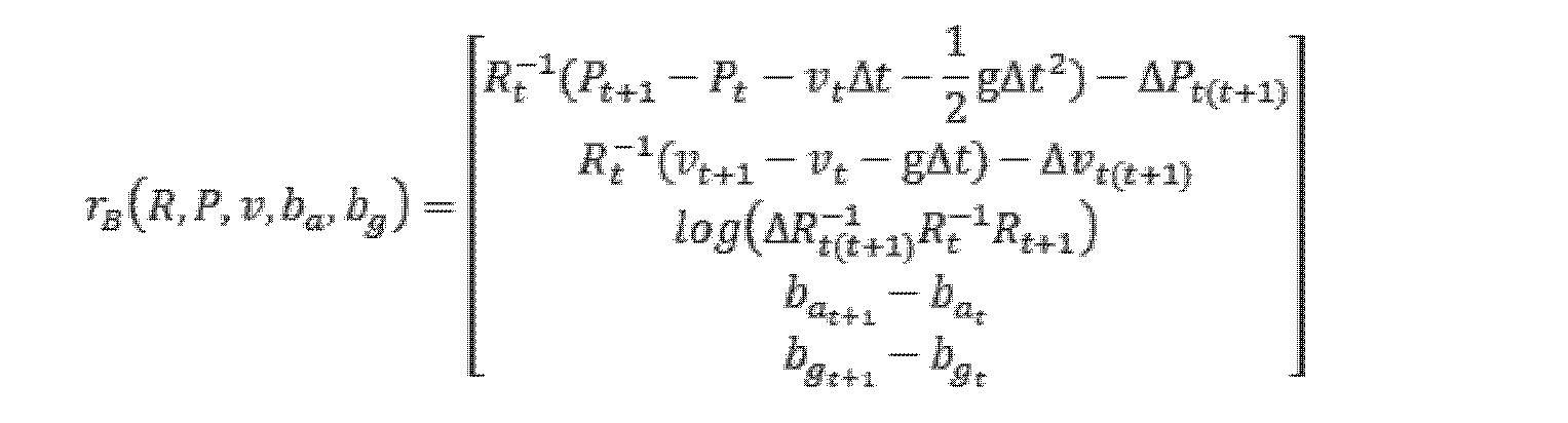
ここで、rB(R,P,v,ba,bg)は、IMU事前積分制約を表し、rBと略称されることができ、tは、時刻を表し、gは、重力加速度を表し、Δtは、t+1時刻とt時刻との時間差を表し、ΔPt(t+1)は、t時刻からt+1時刻までの位置変化量を表し、ΔRt(t+1) -1(本来は上付き文字を下付き文字の直上に配置。以下では注記を省略)は、t時刻からt+1時刻までの姿勢変化量の逆数を表し、Δvt(t+1)は、t時刻からt+1時刻までの速度変化量を表し、log()は、リー群からリー代数のマッピングを表す。 where r B (R, P, v, b a , b g ) represents the IMU pre-integration constraint, which can be abbreviated as r B , t represents the time, and g the gravitational acceleration. where Δt represents the time difference between time t+1 and time t, ΔP t(t+1) represents the amount of position change from time t to time t+1, and ΔR t(t+1) −1 (originally The superscript is placed directly above the subscript.Notes are omitted below) represents the reciprocal of the amount of posture change from time t to time t+1, and Δv t(t+1) is from time t to time t+1 and log() represents the mapping from the Lie group to the Lie algebra.
(3)速度制約関係
車輪速度計は、世界座標系における車輪の動作速度を測定することができる。
(3) Speed Constraint Relationship A wheel speedometer can measure the motion speed of a wheel in the world coordinate system.
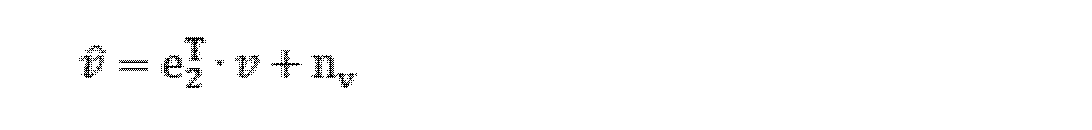
ここで、v(本来はハット記号を伴う。以下では注記を省略)は、車輪速度計の観測値を表し、vは、速度状態変数を表し、e2 T(本来は上付き文字を下付き文字の直上に配置。以下では注記を省略)は、第2項が1、残りが0の3×1ベクトルであり、nvは、車輪速度計の測定ノイズを表す。 where v (originally with a hat symbol, notation is omitted below) represents the wheel speedometer observation, v represents the speed state variable, e 2 T (originally with a superscript subscript placed directly above the letter (note omitted below) is a 3×1 vector with 1s in the second term and 0s in the rest, where n v represents the measurement noise of the wheel speedometer.
IMU座標系と車体座標系との間の外部パラメータを結合すると、IMU座標系における速度を得ることができる。 Combining the extrinsic parameters between the IMU coordinate system and the vehicle body coordinate system, the velocity in the IMU coordinate system can be obtained.

ここで、ωは、IMUジャイロが測定した角速度を表し、LI B(本来は上付き文字を下付き文字の直上に配置。以下では注記を省略)は、車体座標系からIMU座標系までのレバーアーム値であり、外部パラメータ校正により得られる。 Here, ω represents the angular velocity measured by the IMU gyro, and LIB (originally, the superscript is placed directly above the subscript; notes are omitted below) is the distance from the vehicle body coordinate system to the IMU coordinate system. Lever arm value, obtained by external parameter calibration.
要約すると、車輪速度計及びジャイロ観測に基づいて速度に関する誤差関数を確立することができる。 In summary, an error function for speed can be established based on wheel speedometer and gyroscopic observations.

ここで、rV(v)は、IMU事前積分制約を表し、rVと略称されることができる。 where r V (v) represents the IMU pre-integration constraint and can be abbreviated as r V .
(4)点群レジストレーション制約関係
予め設定されたスライディングウィンドウ(以下、スライディングウィンドウ又はスライドウィンドウと略称する)における各キーフレームに対して、k次元ツリー(KD-Tree)アルゴリズムを順次用いて特徴点のLocal Mapへの関連付けを確立することができ、各キーフレームの姿勢は、KD-Treeによる最近傍検索の初期値として用いられる。現フレームに対して、前回のキーフレームの姿勢とIMU積分によるフレーム間姿勢変化量とを用いて点群レジストレーションの初期値を決定し、その後検索により得られた最近傍特徴点セットに基づいて、各線特徴点及び面特徴点に対応する線誤差関数及び面誤差関数を確立する。つまり、線特徴点及び平面特徴点のそれぞれについてKD-Treeアルゴリズムを採用して、初期レジストレーション姿勢による局所マップの最近傍検索を行い、対応する最近傍特徴点セットを得、かつ対応する最近傍特徴点セットに基づいて線誤差関数及び面誤差関数をそれぞれ確立する。
(4) Point cloud registration constraint relationship For each keyframe in a preset sliding window (hereinafter abbreviated as sliding window or sliding window), k-dimensional tree (KD-Tree) algorithm is sequentially used to extract feature points. can be established to the Local Map, and the pose of each keyframe is used as the initial value for the nearest neighbor search by the KD-Tree. For the current frame, the initial value of the point cloud registration is determined using the pose of the previous keyframe and the inter-frame pose change by IMU integration, and then based on the nearest neighbor feature point set obtained by searching , establish a line error function and a plane error function corresponding to each line feature point and plane feature point. That is, the KD-Tree algorithm is adopted for each of the line feature points and the plane feature points to perform the nearest neighbor search of the local map according to the initial registration pose, obtain the corresponding nearest neighbor feature point set, and obtain the corresponding nearest neighbor A line error function and a surface error function are respectively established based on the set of feature points.
いずれかの線特徴点xlに対して、最近傍点セットに基づいて直線フィッティングを行うことができる。最近傍点セットの共分散行列Cを計算し、対応する固有値V及び固有ベクトルEを得ることができる。固有値の最大値が他の2つよりもはるかに大きい場合、直線フィッティングが成功したと考えられ、最大固有値に対応する固有ベクトルが即ち該直線の方向となる。直線フィッティングが成功した場合、線特徴点から対応するフィッティング直線までの距離に基づいて線誤差関数を決定し、特徴点xlから対応する直線までの距離、線誤差関数は、次式によって表される。 For any line feature point x l , line fitting can be performed based on the nearest point set. We can compute the covariance matrix C of the set of nearest neighbor points and obtain the corresponding eigenvalues V and eigenvectors E. If the maximum of the eigenvalues is much larger than the other two, the line fitting is considered successful and the eigenvector corresponding to the maximum eigenvalue is the direction of the line. If the line fitting is successful, determine the line error function based on the distance from the line feature point to the corresponding fitting line, the distance from the feature point xl to the corresponding line, the line error function is expressed by be.
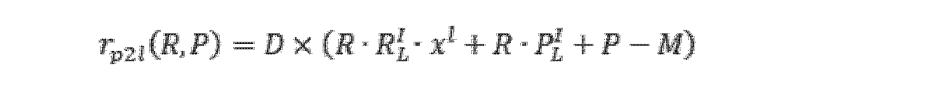
ここで、rp2lは、特徴点xlから対応するフィッティング直線までの距離を表し、Dは、フィッティング直線の方向を表し、Mは、最近傍特徴点セットの座標平均値を表し、RL
I(本来は上付き文字を下付き文字の直上に配置。以下では注記を省略)及びPL
I(本来は上付き文字を下付き文字の直上に配置。以下では注記を省略)は、レーザレーダ座標系からIMU座標系への外部パラメータを表し、
いずれかの面特徴点xpに対して、最近傍点セットに基づいて平面フィッティングを行う必要がある。平面のフィッティングのために、特異値分解(Singular Value Decomposition、SVD)を使用することが選択され、平面フィッティングの平面方程式は、
where r p2l represents the distance from the feature point x l to the corresponding fitting line, D represents the direction of the fitting line, M represents the coordinate mean value of the set of nearest neighbor feature points, and R L I (Originally, superscripts are placed directly above subscripts; notes omitted below) and P L I (originally, superscripts are placed directly above subscripts; notes omitted below) are laser radar represents the extrinsic parameters from the coordinate system to the IMU coordinate system,
For any plane feature point x p , we need to perform plane fitting based on the nearest point set. For the fitting of the plane, it was chosen to use Singular Value Decomposition (SVD), the plane equation for the plane fitting being
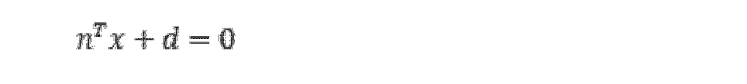
として表され、nは、平面の法線ベクトルを表し、dは、対応する係数である。平面フィッティングが成功した場合、平面特徴点から対応するフィッティング平面までの距離に基づいて面誤差関数を決定し、面特徴点xpから平面までの距離、つまり面誤差関数は、次式によって表される。 where n represents the normal vector of the plane and d is the corresponding coefficient. If the plane fitting is successful, the plane error function is determined based on the distance from the plane feature point to the corresponding fitting plane, and the distance from the plane feature point x p to the plane, that is, the plane error function is expressed by be.
![]()
![]()
ここで、rp2pは平面特徴点xpから対応するフィッティング平面までの距離を表し、RL I及びPL Iは、レーザレーダ座標系からIMU座標系への外部パラメータを表す。 where r p2p represents the distance from the plane feature point x p to the corresponding fitting plane, and R L I and P L I represent the extrinsic parameters from the laser radar coordinate system to the IMU coordinate system.
したがって、前記点群レジストレーション制約は、次式によって表される。 Therefore, the point cloud registration constraint is expressed by the following equation.
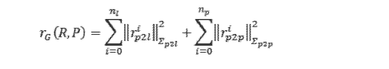
ここで、rG(R,P)は、点群レジストレーション制約を表し、rGと略称されることができ、nlは、現在のキーフレームに含まれる線特徴点の数を表し、npは、現在のキーフレームに含まれる平面特徴点の数を表し、Σは、予め設定されたレジストレーション情報行列である。 where r G (R, P) represents the point cloud registration constraint, which can be abbreviated as r G , n l represents the number of line feature points contained in the current keyframe, and n p represents the number of planar feature points included in the current keyframe, and Σ is a preset registration information matrix.
ステップ202、画像収集装置によって収集された画像に対してセマンティックセグメンテーション処理を行い、セマンティックオブジェクトが存在する領域の二次元輪郭を得る。
本発明の実施例におけるセマンティックオブジェクトは車線及び/又は道路ポールを含むことができ、説明を容易にするために、以下では車線及び道路ポールを同時に含むことを例とする。まず深度学習に基づくセマンティックセグメンテーション方法によって画像から車線及び道路ポールに対応する画素領域を検出した後、レーザレーダによって提供される深度情報と結合して車線及び道路ポールの3D情報を算出することができる。フレーム間セマンティック情報のデータ関連付け及び組合せ最適化を容易にするために、車線及び道路ポールに対して幾何学的形状でパラメータ化することができる。 A semantic object in an embodiment of the present invention may include lanes and/or road poles, and for ease of explanation, the following example includes lanes and road poles at the same time. First, the pixel regions corresponding to the lanes and road poles are detected from the image by a semantic segmentation method based on depth learning, and then the 3D information of the lanes and road poles can be calculated by combining with the depth information provided by the laser radar. . To facilitate data association and combinatorial optimization of inter-frame semantic information, lanes and road poles can be parameterized with geometry.
車線に対して、対応する三次元輪郭は、空間矩形を含み、空間矩形の特徴量は、中心点(C)、法線ベクトル(N)、長辺ベクトル(T)、長さ(L)、及び幅(W)を含み、各破線車線は、1つの空間矩形に対応し、各実線車線は、その長さ及び曲率に基づいて複数の空間矩形に対応する。 For a lane, the corresponding three-dimensional contour includes a spatial rectangle, and the features of the spatial rectangle are the center point (C), normal vector (N), long side vector (T), length (L), and width (W), each dashed lane corresponds to one spatial rectangle, and each solid lane corresponds to multiple spatial rectangles based on its length and curvature.
例示的に、セマンティックセグメンテーションにより、画像から車線に属する画素領域を抽出し、その後、画像処理により車線領域の2D輪郭をさらに得ることができる。 Exemplarily, the semantic segmentation extracts the pixel regions belonging to the lanes from the image, and then the 2D contours of the lane regions can be further obtained by image processing.
道路ポールに対して、対応する三次元輪郭はピラーを含み、ピラーの特徴量は、上面中心点(開始点とも呼ばれ、Sと表記する)、底面中心点(終了点とも呼ばれ、Eと表記する)及び半径(d)を含む。 For road poles, the corresponding three-dimensional contours include pillars whose features are the top center point (also called the start point, denoted by S), the bottom center point (also called the end point, denoted by E ) and radius (d).
例示的に、セマンティックセグメンテーションにより、画像から道路ポールに属する画素領域を抽出し、その後、画像処理により道路ポールの2D輪郭をさらに得ることができる。 Illustratively, the semantic segmentation extracts the pixel regions belonging to the road poles from the image, after which the 2D contours of the road poles can also be obtained by image processing.
ステップ203、点群収集装置によって収集された点群を画像に投影し、かつ二次元輪郭に基づいてセマンティックオブジェクトに対応するターゲット三次元点を決定する。
例示的に、カメラ内部パラメータと、カメラとレーザレーダとの間の外部パラメータとによって、レーザレーダによって測定された3D点を画像に投影し、かつ2D輪郭に基づいて車線及び道路ポールに対応するレーザレーダ点を得ることができる。 Illustratively, the camera intrinsic parameters and the extrinsic parameters between the camera and the laser radar project the 3D points measured by the laser radar onto an image, and based on the 2D contours, the laser corresponding lanes and road poles. You can get radar points.
ステップ204、ターゲット三次元点に対して平面フィッティング又は直線フィッティングを行い、対応する空間方程式を得る。
車線に対して、対応する領域は通常1つの平面上にあるので、上記レーザレーダ点に対して平面フィッティングを行うことで対応する空間平面方程式を得ることができる。 For a lane, the corresponding area usually lies on a plane, so a plane fitting can be performed on the laser radar points to obtain the corresponding spatial plane equation.
前記空間平面方程式は、次式によって表される。 The spatial plane equation is expressed by the following equation.

ここで、 here,
は、単位法線ベクトルを表し、dは、画像収集装置座標系における座標原点から空間平面までの距離を表す。 represents the unit normal vector and d represents the distance from the coordinate origin in the image capture device coordinate system to the spatial plane.
道路ポールに対して、道路ポールに属するレーザ点に対して直線フィッティングを行うことにより、道路ポールに対応する直線方程式を得ることができ、かつ道路ポールに属する各レーザ点から該直線までの距離を算出することができ、該距離の平均値を道路ポール半径dとして、かつ方向ベクトル A linear equation corresponding to the road pole can be obtained by performing linear fitting to the laser points belonging to the road pole, and the distance from each laser point belonging to the road pole to the straight line can be obtained. can be calculated, the average of the distances as the road pole radius d, and the direction vector

と道路ポール上の一点 and a point on the road pole

とで該直線を表す。 and represent the straight line.
ステップ205、二次元輪郭の画素座標、画像収集装置の内部パラメータ、及び画像収集装置と点群収集装置との間の外部パラメータに基づいて、ターゲット三次元点の三次元座標を決定する。
車線に対して、幾何学的関係に基づいて、2D輪郭に対応する3D点座標が分かり、つまり、ターゲット三次元点の三次元座標は、次式によって表される。 For a lane, the 3D point coordinates corresponding to the 2D contour are known based on the geometrical relationship, ie the 3D coordinates of the target 3D point are given by:
ここで、u及びvは、二次元輪郭の点の画素座標を表し、fx、fy、cx、及びcyは、カメラ内部パラメータを表し、 where u and v represent the pixel coordinates of the 2D contour points, fx , fy , cx , and cy represent the camera intrinsic parameters,
![]()
![]()
である。 is.
道路ポールに対して、道路ポールの2つの端点の画素座標及び直線方程式が既知であるため、幾何学的関係に基づいて、2つの端点S及びEの三次元座標を得ることができ、つまり、ターゲット三次元点の三次元座標は、次式によって表される。 For a road pole, since the pixel coordinates and the linear equation of the two endpoints of the road pole are known, we can obtain the three-dimensional coordinates of the two endpoints S and E based on the geometrical relationship, that is, The 3D coordinates of the target 3D point are represented by the following equations.
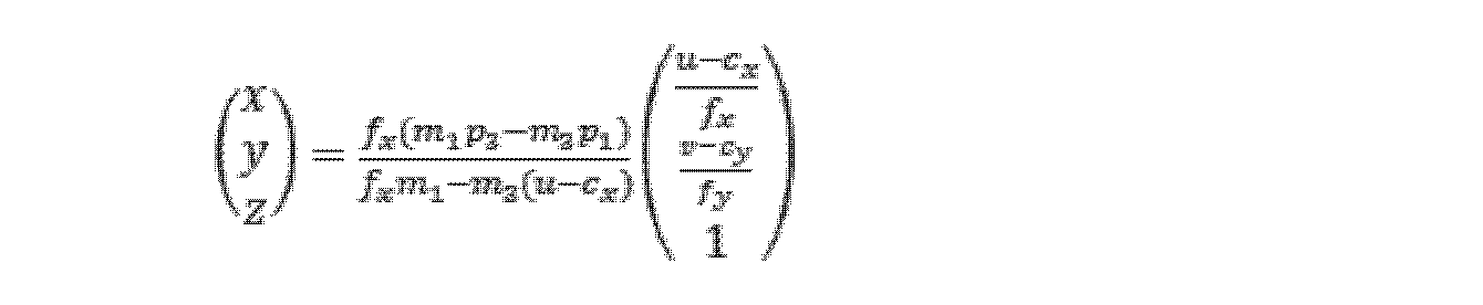
ここで、u及びvは、両端点の画素座標を表し、fx、fy、cx、及びcyは、カメラ内部パラメータを表す。 where u and v represent the pixel coordinates of the endpoints, and fx , fy , cx , and cy represent camera intrinsic parameters.
ステップ206、空間方程式及びターゲット三次元点の三次元座標に基づいてターゲット三次元点をフィッティングし、セマンティックオブジェクトに対応する三次元輪郭の観測値を得る。
車線に対して、PCA法を用いて車線輪郭に対応する3D点セットをフィッティングすることができ、3D矩形の中心点、法線ベクトル、長辺ベクトル、長さ、及び幅を得ることができる。同様に、道路ポールに対して、PCA法を用いて道路ポールに対応する3D点セットをフィッティングすることができ、ピラーの上面中心点、底面中心点、及び半径を得ることができる。 For lanes, the PCA method can be used to fit a 3D point set corresponding to the lane contour, and the center point, normal vector, long side vector, length, and width of the 3D rectangle can be obtained. Similarly, for road poles, the PCA method can be used to fit a 3D point set corresponding to the road pole, and the top center point, bottom center point, and radius of the pillar can be obtained.
ステップ207、予め設定されたスライディングウィンドウにおける各キーフレームに対して、現在のキーフレームにおける三次元輪郭の観測値とセマンティックオブジェクト状態変数集合との間の関連付けを確立することで、セマンティックオブジェクト状態変数集合におけるセマンティックオブジェクト状態変数を更新し、かつ現在のキーフレームにおける各三次元輪郭に対応する誤差関数を確立する。
車線に対して、スライディングウィンドウにおける全ての車線の観測を融合してマップ作成精度を向上させるために、動的に更新される車線状態変数集合Mを維持することができる。スライディングウィンドウ内の各フレームのフィッティングから得られた車線矩形は、いずれもMと関連付けられ、かつ誤差関数を確立する。 For lanes, a dynamically updated set of lane state variables M can be maintained to fuse all lane observations in a sliding window to improve mapping accuracy. Each lane rectangle obtained from the fitting of each frame within the sliding window is associated with M and establishes an error function.
破線空間矩形に対して、中心点座標に基づいて観測とMの関連付けを確立することができ、まず、現フレームのグローバル姿勢に基づいて中心点を座標変換し、該矩形中心点の世界座標系における座標を得、対応する状態変数をある閾値の範囲内で見つけることができる場合、即ち関連付けが成功したと考えられ、1つの誤差関数を確立し、対応する状態変数を見つけることができない場合、新たな状態変数を作成し、かつ誤差関数を確立する。 For a dashed space rectangle, we can establish an association between observations and M based on the center point coordinates, first transform the center point according to the global pose of the current frame, and put the rectangle center point in the world coordinate system and can find the corresponding state variable within a certain threshold, i.e. the association is considered successful, establish one error function, and if the corresponding state variable cannot be found, Create a new state variable and establish an error function.
破線車線誤差関数は、次式によって表される。 The dashed line lane error function is expressed by the following equation.

ここで、rd(R,P,M)は、破線車線誤差関数を表し、rdと略称されることができ、Pは、現在のキーフレームの世界座標系における位置を表し、Rは、現在のキーフレームの世界座標系における姿勢を表し、Mは、空間矩形状態変数を表し、Cは、中心点を表し、Nは、法線ベクトルを表し、Tは、長辺ベクトルを表し、Lは、長さを表し、Wは、幅を表し、上添え字Wは、状態変数に対応する世界座標系を表し、上添え字Iは慣性航法座標系を表し、観測値に対応する。 where r d (R, P, M) represents the dashed lane error function and can be abbreviated as r d , P represents the position of the current keyframe in the world coordinate system, and R is represents the pose in the world coordinate system of the current keyframe, M represents the spatial rectangular state variable, C represents the center point, N represents the normal vector, T represents the long side vector, L represents the length, W represents the width, the superscript W represents the world coordinate system corresponding to the state variables, and the superscript I represents the inertial navigation coordinate system corresponding to the observations.
実線空間矩形に対して、関連付け方式は、破線空間矩形と類似してもよく、つまり、中心点座標に基づいて観測とMの関連付けを確立することができ、まず、現フレームのグローバル姿勢に基づいて中心点を座標変換し、該矩形中心点の世界座標系における座標を得、対応する状態変数をある閾値の範囲内で見つけることができる場合、即ち関連付けが成功したと考えられ、1つの誤差関数を確立し、対応する状態変数を見つけることができない場合、新たな状態変数を作成し、かつ誤差関数を確立する。 For the solid-line space rectangle, the association scheme may be similar to the dashed-line space rectangle, i.e., we can establish an association between observations and M based on the center point coordinates, first based on the global pose of the current frame to obtain the coordinates of the rectangle center point in the world coordinate system, and if the corresponding state variables can be found within a certain threshold, i.e. the association is considered successful, and one error If a function is established and the corresponding state variable cannot be found, a new state variable is created and an error function is established.
実線は連続的であり、かつ状態変数と各フレームのフィッティング結果との厳密な対応関係がないため、状態変数の中心点から各観測中心線までの距離を確立する必要があり、矩形の長さを最適化する必要がなく、実線車線誤差関数は、次式によって表される。 Since the solid line is continuous and there is no exact correspondence between the state variables and the fitting results for each frame, the distance from the center point of the state variables to each observation center line must be established, and the length of the rectangle , the solid lane error function is given by
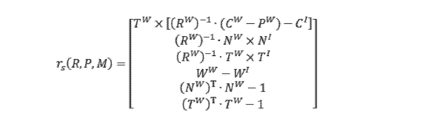
ここで、rs(R,P,M)は、実線車線誤差関数を表し、rsと略称されることができ、Pは、現在のキーフレームの世界座標系における位置を表し、Rは、現在のキーフレームの世界座標系における姿勢を表し、Mは、空間矩形状態変数を表し、Cは、中心点を表し、Nは、法線ベクトルを表し、Tは、長辺ベクトルを表し、Wは、幅を表し、上添え字Wは、状態変数に対応する世界座標系を表し、上添え字Iは慣性航法座標系を表し、観測値に対応する。 where r s (R, P, M) represents the solid lane error function and can be abbreviated as r s , P represents the position of the current keyframe in the world coordinate system, and R is represents the pose in the world coordinate system of the current keyframe, M represents the spatial rectangular state variable, C represents the center point, N represents the normal vector, T represents the long side vector, W represents the width, the superscript W represents the world coordinate system corresponding to the state variables, and the superscript I represents the inertial navigation coordinate system corresponding to the observations.
1フレーム内の全ての車線フィッティング結果を統合することによって、現在のキーフレームにおける空間矩形に対応する車線誤差関数を得ることができ、次式によって表されることができる。 By integrating all lane fitting results in one frame, the lane error function corresponding to the spatial rectangle in the current keyframe can be obtained and can be expressed by the following equation.

ここで、rL(R,P,M)は、現在のキーフレームにおける空間矩形に対応する車線誤差関数を表し、rLと略称されることができ、ndは、現在のキーフレームにおける破線車線に対応する空間矩形状態変数の数を表し、nsは、現在のキーフレームにおける実線車線に対応する空間矩形状態変数の数を表し、Σdは、予め設定された破線情報行列を表し、Σsは、予め設定された実線情報行列を表す。 where r L (R, P, M) represents the lane error function corresponding to the spatial rectangle in the current keyframe, which can be abbreviated as r L , and n d is the dashed line represents the number of spatial rectangular state variables corresponding to lanes, n s represents the number of spatial rectangular state variables corresponding to solid lanes in the current keyframe, Σ d represents the preset dashed line information matrix, Σ s represents a preset solid line information matrix.
道路ポールに対して、スライディングウィンドウにおける全ての道路ポールの観測を融合してマップ作成精度を向上させるために、動的に更新される道路ポール状態変数集合Nを維持することができる。スライディングウィンドウ内の各フレームのフィッティングから得られた道路ポールは、いずれもNと関連付けられ、かつ誤差関数を確立する。道路ポールの2つの端点座標に基づいて観測とNの関連付けを確立することができる。まず、現フレームのグローバル姿勢に基づいて端点座標を座標変換し、該両端点の世界座標系における座標を得る。状態変数集合Nに対して、ある状態変数と現在の道路ポールの両端点との距離差が閾値よりも小さいものがある場合、関連付けが成功したと考えられ、1つの誤差関数を確立し、対応する状態変数を見つけることができない場合、新たな状態変数を作成し、かつ誤差関数を確立する。 For road poles, a dynamically updated set of road pole state variables N can be maintained to fuse all road pole observations in the sliding window to improve mapping accuracy. Each road pole obtained from fitting each frame within the sliding window is associated with N and establishes an error function. An association of observations and N can be established based on the coordinates of the two endpoints of the road pole. First, the coordinates of the endpoints are transformed based on the global orientation of the current frame to obtain the coordinates of the endpoints in the world coordinate system. If, for a set of state variables N, there is a distance difference between a state variable and the endpoints of the current road pole that is less than a threshold, then the association is considered successful, and an error function is established and the corresponding If we cannot find a state variable to do so, we create a new state variable and establish an error function.
道路ポール誤差関数は、次式によって表される。 A road pole error function is expressed by the following equation.
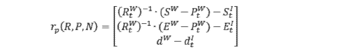
ここで、rp(R,P,N)は、破線車線誤差関数を表し、rpと略称されることができ、Pは、現在のキーフレームの世界座標系における位置を表し、Rは、現在のキーフレームの世界座標系における姿勢を表し、Sは、ピラー上面中心点座標を表し、Eは、ピラー底面中心点座標を表し、dは、ピラー半径を表す。 where r p (R, P, N) represents the dashed lane error function and can be abbreviated as r p , P represents the position of the current keyframe in the world coordinate system, and R is Represents the orientation of the current keyframe in the world coordinate system, S represents the pillar top center point coordinates, E represents the pillar bottom center point coordinates, and d represents the pillar radius.
1フレーム内の全ての道路ポールフィッティング結果を統合することによって、現在のキーフレームにおけるピラーに対応する道路ポール誤差関数を得ることができ、次式によって表されることができる。 By integrating all road pole fitting results in one frame, the road pole error function corresponding to the pillar in the current keyframe can be obtained and can be expressed by the following equation.

ここで、rP(R,P,N)は、現在のキーフレームにおける空間矩形に対応する車線誤差関数を表し、rPと略称されることができ、npは、現在のキーフレームにおける道路ポールフィッティング結果に含まれる道路ポールの数、つまり道路ポールに対応するピラー状態変数の数を表し、Σpは、予め設定された道路ポール情報行列である。 where r P (R, P, N) represents the lane error function corresponding to the spatial rectangle in the current keyframe and can be abbreviated as r P and n p is the road represents the number of road poles included in the pole fitting result, that is, the number of pillar state variables corresponding to road poles, and Σ p is a preset road pole information matrix.
ステップ208、予め設定されたスライディングウィンドウにおける各キーフレームにそれぞれ対応する誤差関数に基づいて、セマンティック制約関係を確立する。
例示的に、セマンティック制約関係は、以下のように表されることができる。 Illustratively, the semantic constraint relationship can be expressed as follows.

ここで、nkは、予め設定されたスライディングウィンドウにおけるキーフレームの数を表す。 Here, nk represents the number of keyframes in the preset sliding window.
ステップ209、姿勢制約関係及びセマンティック制約関係に基づいて予め設定されたスライディングウィンドウ内の各キーフレームに対応する組合せ最適化目的関数を構築する。
スライディングウィンドウ内の各フレームの事前積分制約rB、速度制約rV、絶対姿勢制約rI、点群レジストレーション制約rG、車線制約rL、及び道路ポール制約rPを統合することにより、以下のような組合せ最適化目的関数を確立することができる。 By integrating the pre-integration constraint r B , velocity constraint r V , absolute pose constraint r I , point cloud registration constraint r G , lane constraint r L , and road pole constraint r P for each frame within the sliding window, One can establish a combinatorial optimization objective function such as
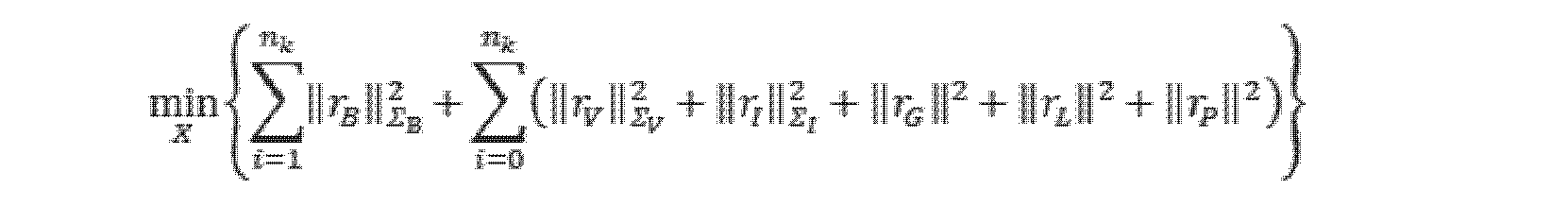
ここで、 here,

であり、nkは、予め設定されたスライディングウィンドウにおけるキーフレームの数を表し、Σは、予め設定された情報行列を表す。 , n k represents the number of keyframes in a preset sliding window, and Σ represents a preset information matrix.
ステップ210、組合せ最適化目的関数について求解を行い、各状態変数の推定値を得、ここで、セマンティックオブジェクト状態変数の推定値をセマンティック結果と表記し、位置状態変数及び姿勢状態変数の推定値を姿勢結果と表記する。
例示的に、Ceres-Solverを用いて上記組合せ最適化目的関数を求解し、各状態変数の推定値を得ることができる。 Illustratively, Ceres-Solver can be used to solve the above combinatorial optimization objective function to obtain an estimate of each state variable.
ステップ211、セマンティクス結果及び姿勢結果に基づいてセマンティクスマップ及び点群マップを構築する。
例示的に、車線にとって、幾何学的関係に基づいてセマンティック結果から空間矩形の4つのコーナーを計算し、各コーナーに対して繋ぎ合わせ処理を行い、車線の3D輪郭を得、全ての車線の3D輪郭を統合し、車線のセマンティックマップを得ることができる。ここで、破線車線に対して、3D輪郭は、空間矩形の4つのコーナーを順次繋ぎ合わせたものに対応し、実線車線に対して、3D輪郭は、長さ方向におけるコーナーを空間順に順次繋ぎ合わせて得られる2つの辺線に対応する。 Illustratively, for a lane, compute the four corners of the spatial rectangle from the semantic results based on geometric relationships, perform a stitching operation on each corner, obtain the 3D contour of the lane, and obtain the 3D contour of all lanes. We can integrate the contours and get a semantic map of the lanes. Here, for the dashed lane, the 3D contour corresponds to the sequential joining of the four corners of the spatial rectangle, and for the solid lane, the 3D contour corresponds to the sequential spatial joining of the corners in the length direction. corresponds to the two sides obtained by
例示的に、道路ポールにとって、幾何学的関係に基づいてセマンティック結果から上面中心点及び底面中心点を決定し、さらに半径に基づいて道路ポールの3D輪郭を構築し、全ての道路ポールの3D輪郭を統合し、道路ポールのセマンティックマップを得ることができる。 Illustratively, for a road pole, determine the top center point and the bottom center point from the semantic results based on the geometric relationship, further construct the 3D contour of the road pole based on the radius, and construct the 3D contour of all road poles. to get a semantic map of road poles.
点群マップに対して、最適化された姿勢を用いて動き補償された点群を重畳すれば、高密度の点群マップを得ることができる。 A high-density point cloud map can be obtained by superimposing a point cloud that has been motion-compensated using the optimized pose on the point cloud map.
本発明の実施例は、上記技術案を採用することにより、まず、複合ナビゲーション装置、車輪速度計、カメラ、及びレーザレーダの観測データに対して融合モデリングを行うことにより、システム状態に関するグローバル制約及び局所一貫性制約を確立し、姿勢推定の精度及びロバスト性を効果的に向上させ、かつトンネル、海を跨ぐ橋梁などのシーンでの正常なマップ作成を実現することができ、画像に基づくセマンティックセグメンテーション技術により、車線及び道路ポールに属する画素領域を効果的に検出し、その後、レーザレーダの3D観測と結合して、車線及び道路ポールの3D情報を算出し、かつタイミング情報を利用して異なる時刻の車線観測と道路ポール観測に対して組合せ最適化を行い、セマンティックマップの精度及び一貫性を向上させる。 By adopting the above technical solution, the embodiment of the present invention first performs fusion modeling on the observation data of the compound navigation device, wheel speedometer, camera, and laser radar to obtain global constraints and It can establish local consistency constraints, effectively improve the accuracy and robustness of pose estimation, and realize normal map creation in scenes such as tunnels, bridges across the sea, and image-based semantic segmentation The technology effectively detects the pixel regions belonging to the lanes and road poles, then combines with the 3D observation of laser radar to calculate the 3D information of the lanes and road poles, and uses the timing information to detect different time points. The lane observations and road pole observations are combinatorially optimized to improve the accuracy and consistency of the semantic map.
本発明の実施例の技術案の有効性を検証するために、GNSS、IMU、車輪速度計、カメラ、レーザレーダなどのセンサを装備したデータ収集車両を用いて、様々な複雑な道路状況における道路データを収集して実験検証を行う。図4は、本発明の実施例によって提供される橋梁シーンのマップ構築結果の概略図であり、ここで、サブ図Aは、橋梁シーン図であり、サブ図Bは、構築された点群マップであり、サブ図Cは、構築されたセマンティックマップの概略図であり、サブ図Dは、最適化された位置(X、Y、及びZは、それぞれ、空間座標系における3つの座標成分を表す)と真値との差のプロットである。図5は、本発明の実施例によって提供されるトンネルシーンのマップ構築結果の概略図であり、サブ図Aは、トンネルシーン図であり、サブ図Bは、構築された点群マップであり、サブ図Cは、構築されたセマンティックマップの概略図であり、サブ図Dは、最適化された位置(X、Y、及びZは、それぞれ、空間座標系における3つの座標成分を表す)と真値との差のプロットである。収集車両によって図4に示すような橋梁シーンでの関連データを収集し、及び図5に示すようなトンネルシーンでの関連データを収集し、本発明の実施例によって提供される技術案を採用してマップ構築を行い、セマンティックオブジェクトが車線であることを例とする。収集車両は、高精度の商用の複合ナビゲーション装置を装備し、その後、処理結果は姿勢の真値として利用可能であり、車線マップの精度を検証するために、一部の車線の破線コーナーの空間位置座標(以下、絶対位置点と略称される)をマップ作成装置によって測定する。図4及び図5を参照すると、本発明の実施例によって提供される技術案は、海を跨ぐ橋梁、トンネルなどの複雑な道路状況においても依然としてマップ作成が可能であり、計算で得られた位置と真値との誤差が10cm以内であり、さらに、構築された車線マップのコーナー座標と絶対位置点との差も10cm以内であり、マップ作成の精度と正確度を効果的に保証する。 In order to verify the effectiveness of the technical solution of the embodiment of the present invention, a data collection vehicle equipped with sensors such as GNSS, IMU, wheel speedometer, camera, laser radar, etc., was used to analyze the road in various complicated road conditions. Collect data and perform experimental verification. FIG. 4 is a schematic diagram of map construction results of a bridge scene provided by an embodiment of the present invention, where subfigure A is a bridge scene diagram and subfigure B is a constructed point cloud map , subfigure C is a schematic of the constructed semantic map, and subfigure D is the optimized position (X, Y, and Z respectively represent the three coordinate components in the spatial coordinate system ) and the true value. FIG. 5 is a schematic diagram of a tunnel scene map construction result provided by an embodiment of the present invention, subfigure A is a tunnel scene diagram, subfigure B is a constructed point cloud map, Subfigure C is a schematic of the constructed semantic map, subfigure D shows the optimized position (X, Y, and Z respectively represent the three coordinate components in the spatial coordinate system) and the true is a plot of the difference between the values. Collecting the related data in the bridge scene as shown in FIG. 4 and the related data in the tunnel scene as shown in FIG. For example, we construct a map using The collection vehicle is equipped with a high-precision commercial compound navigation device, then the processing results are available as the true value of the attitude, and the space of the dashed corners of some lanes is used to verify the accuracy of the lane map. Position coordinates (hereinafter abbreviated as absolute position points) are measured by the mapping device. 4 and 5, the technical solution provided by the embodiment of the present invention still enables mapping even in complex road conditions such as cross-sea bridges, tunnels, etc., and the calculated position and the true value is within 10 cm, and the difference between the corner coordinates of the constructed lane map and the absolute position point is also within 10 cm, effectively guaranteeing the accuracy and accuracy of map creation.
図6は、本発明の実施例によって提供されるマップ構築装置の構造ブロック図であり、該装置は、ソフトウェア及び/又はハードウェアで実現されることができ、一般的にコンピュータ装置に集積されることができ、マップ構築方法を実行することによりマップ構築を行うことができる。図6に示すように、該装置は、
予め設定されたセンサによって収集されたセンサデータを取得するためのデータ取得モジュール601と、
センサデータに基づいて移動体の姿勢制約関係及びセマンティックオブジェクトのセマンティック制約関係を確立するための制約関係確立モジュール602と、
前記姿勢制約関係及び前記セマンティック制約関係に基づいて組合せ最適化求解を行い、セマンティックオブジェクトのセマンティック結果及び前記移動体の姿勢結果を決定するための組合せ求解モジュール603と、
前記セマンティック結果及び前記姿勢結果に基づいてセマンティックマップ及び点群マップを構築するためのマップ構築モジュール604と、を含む。
FIG. 6 is a structural block diagram of a map construction device provided by an embodiment of the present invention, which can be implemented in software and/or hardware, and is generally integrated into a computer device. and map construction can be performed by executing the map construction method. As shown in FIG. 6, the device comprises:
a
a constraint
a
a
本発明の実施例で提供されるマップ構築装置は、セマンティックマップの構築過程と点群マップの構築過程を融合し、姿勢制約関係とセマンティック制約関係を利用して組合せ求解を行うことで、セマンティック結果と姿勢結果が相互制約関係を形成することができ、セマンティックマップと点群マップを迅速かつ正確に得ることができ、さらにより精確な高精度マップを得ることができ、移動体の自律移動性能を向上させることに有利である。 The map constructing apparatus provided in the embodiment of the present invention integrates the semantic map constructing process and the point cloud map constructing process, and uses the attitude constraint relation and the semantic constraint relation to solve the combination, thereby obtaining the semantic result and attitude results can form a mutual constraint relationship, semantic maps and point cloud maps can be obtained quickly and accurately, more accurate high-precision maps can be obtained, and the autonomous movement performance of the mobile body can be improved. It is advantageous to improve
任意選択で、予め設定されたセンサによって収集されたセンサデータは、画像収集装置によって収集された画像と、点群収集装置によって収集された点群とを含み、制約関係確立モジュールは、具体的には、前記画像及び前記点群に基づいて、各セマンティックオブジェクトに対応する三次元輪郭の観測値を決定することと、前記三次元輪郭の観測値に基づいてセマンティック制約関係を確立することとに用いられる。 Optionally, the sensor data collected by the preset sensors include images collected by the image collector and point clouds collected by the point cloud collector, and the constraint relationship establishment module specifically includes is used to determine 3D contour observations corresponding to each semantic object based on the image and the point cloud, and to establish semantic constraint relationships based on the 3D contour observations. be done.
任意選択で、前記画像及び前記点群に基づいて、セマンティックオブジェクトに対応する三次元輪郭の観測値を決定する前記ステップは、前記画像に対してセマンティックセグメンテーション処理を行い、セマンティックオブジェクトが存在する領域の二次元輪郭を得るステップと、前記点群を前記画像に投影し、かつ前記二次元輪郭に基づいて前記セマンティックオブジェクトに対応するターゲット三次元点を決定するステップと、前記ターゲット三次元点をフィッティングし、前記セマンティックオブジェクトに対応する三次元輪郭の観測値を得るステップと、を含む。 Optionally, said step of determining, based on said image and said point cloud, observations of three-dimensional contours corresponding to semantic objects includes performing a semantic segmentation operation on said images to determine regions in which semantic objects reside. obtaining a 2D contour; projecting the point cloud onto the image and determining target 3D points corresponding to the semantic object based on the 2D contour; and fitting the target 3D points. , obtaining observations of three-dimensional contours corresponding to said semantic objects.
任意選択で、前記ターゲット三次元点をフィッティングし、前記セマンティックオブジェクトに対応する三次元輪郭の観測値を得る前記ステップは、前記ターゲット三次元点に対して平面フィッティング又は直線フィッティングを行い、対応する空間方程式を得るステップと、前記二次元輪郭の画素座標、前記画像収集装置の内部パラメータ、及び前記画像収集装置と前記点群収集装置との間の外部パラメータに基づいて前記ターゲット三次元点の三次元座標を決定するステップと、前記空間方程式及び前記ターゲット三次元点の三次元座標に基づいて前記ターゲット三次元点をフィッティングし、セマンティックオブジェクトに対応する三次元輪郭の観測値を得るステップと、を含む。 Optionally, said step of fitting said target 3D points to obtain observations of a 3D contour corresponding to said semantic object includes performing plane fitting or line fitting to said target 3D points and corresponding spatial obtaining an equation; and calculating the 3D of the target 3D point based on the pixel coordinates of the 2D contour, the intrinsic parameters of the image capture device, and the extrinsic parameters between the image capture device and the point cloud capture device. determining coordinates; and fitting the target 3D points based on the spatial equation and the 3D coordinates of the target 3D points to obtain observations of 3D contours corresponding to semantic objects. .
任意選択で、前記セマンティックオブジェクトは車線を含み、前記車線に対応する三次元輪郭は空間矩形を含み、前記空間矩形の特徴量は中心点、法線ベクトル、長辺ベクトル、長さ、及び幅のうちの少なくとも1つを含み、前記車線に対応するターゲット三次元点に対応するフィッティング方式は平面フィッティングであり、これにより対応する空間平面方程式を得、ここで、各破線車線は、1つの空間矩形に対応し、各実線車線は、その長さ及び曲率に基づいて複数の空間矩形に対応する。 Optionally, said semantic object comprises a lane, said three-dimensional contour corresponding to said lane comprises a spatial rectangle, and features of said spatial rectangle include a center point, a normal vector, a long side vector, a length and a width. and the fitting method corresponding to the target 3D points corresponding to the lanes is plane fitting, thereby obtaining the corresponding spatial plane equations, where each dashed lane is a spatial rectangle , and each solid lane corresponds to a plurality of spatial rectangles based on its length and curvature.
任意選択で、前記セマンティックオブジェクトは、道路ポールを含み、前記道路ポールに対応する三次元輪郭は、ピラーを含み、前記ピラーの特徴量は、上面中心点、底面中心点、及び半径のうちの少なくとも1つを含み、前記道路ポールに対応するターゲット三次元点に対応するフィッティング方式は直線フィッティングであり、これにより対応する空間直線方程式を得る。 Optionally, the semantic object includes a road pole, the three-dimensional contour corresponding to the road pole includes a pillar, and the feature of the pillar is at least one of a top center point, a bottom center point, and a radius. The fitting method, including one, corresponding to the target 3D points corresponding to the road poles is linear fitting, which obtains the corresponding spatial linear equations.
任意選択で、前記三次元輪郭の観測値に基づいてセマンティック制約関係を確立する前記ステップは、予め設定されたスライディングウィンドウにおける各キーフレームに対して、現在のキーフレームにおける三次元輪郭の観測値とセマンティックオブジェクト状態変数集合との間の関連付けを確立することで、前記セマンティックオブジェクト状態変数集合におけるセマンティックオブジェクト状態変数を更新し、かつ現在のキーフレームにおける各三次元輪郭に対応する誤差関数を確立するステップと、前記予め設定されたスライディングウィンドウにおける各キーフレームにそれぞれ対応する誤差関数に基づいて、セマンティック制約関係を確立するステップと、を含む。 Optionally, said step of establishing a semantic constraint relationship based on said 3D contour observations includes, for each keyframe in a preset sliding window, the 3D contour observations at a current keyframe and Updating the semantic object state variables in the set of semantic object state variables by establishing an association between them and establishing an error function corresponding to each three-dimensional contour at the current keyframe. and establishing a semantic constraint relationship based on an error function respectively corresponding to each keyframe in the preset sliding window.
任意選択で、車線に対して、現在のキーフレームにおける三次元輪郭の観測値とセマンティックオブジェクト状態変数集合との間の関連付けを確立することで、前記セマンティックオブジェクト状態変数集合におけるセマンティックオブジェクト状態変数を更新する前記ステップは、現在のキーフレームにおける各空間矩形に対して、同一座標系において現在の空間矩形の中心点の観測値と車線状態変数集合における各矩形状態変数の中心点との第1距離を計算し、第1の予め設定された距離閾値より小さい第1距離が存在すれば、現在の空間矩形と対応する矩形状態変数とを関連付け、存在しなければ、車線状態変数集合において現在の空間矩形に対応する矩形状態変数を作成するステップを含む。 Optionally, for lanes, updating the semantic object state variables in said set of semantic object state variables by establishing an association between the observation of the 3D contour at the current keyframe and the semantic object state variable set. calculating, for each spatial rectangle in the current keyframe, a first distance between the observed value of the center point of the current spatial rectangle in the same coordinate system and the center point of each rectangle state variable in the lane state variable set calculating, if a first distance less than a first preset distance threshold exists, associate the current spatial rectangle with the corresponding rectangle state variable; if not, the current spatial rectangle in the lane state variable set creating a rectangular state variable corresponding to .
任意選択で、現在のキーフレームにおける誤差関数は、空間矩形に対応する車線誤差関数及び/又はピラーに対応する道路ポール誤差関数を含み、前記車線誤差関数は、各破線車線の誤差関数及び各実線車線の誤差関数を含む。 Optionally, the error function at the current keyframe comprises a lane error function corresponding to a spatial rectangle and/or a road pole error function corresponding to a pillar, said lane error functions being an error function for each dashed lane and each solid line Contains the lane error function.
任意選択で、破線車線の誤差関数は、中心点、法線ベクトル、長辺ベクトル、長さ、及び幅に関する状態変数と観測値との誤差関数と、法線ベクトル及び長辺ベクトルの状態変数のそれぞれと単位ベクトルとの誤差関数とを含む。 Optionally, the dashed lane error function is the error function between the state variables and observations for the center point, normal vector, long vector, length and width, and the state variables for the normal and long vectors. each and the error function with the unit vector.
任意選択で、実線車線の誤差関数は、法線ベクトル、長辺ベクトル、及び幅に関する状態変数と観測値との誤差関数と、中心点の状態変数と観測中心線との第2の距離と、法線ベクトル及び長辺ベクトルの状態変数のそれぞれと単位ベクトルとの誤差関数とを含む。 Optionally, the solid lane error function is a state variable-observed error function for the normal vector, the long side vector, and the width, and a second distance between the center point state variable and the observed center line; It contains the error function between each of the normal vector and long vector state variables and the unit vector.
任意選択で、前記予め設定されたセンサは、GNSS、慣性測定ユニットIMU、車輪速度計、画像収集装置、及び点群収集装置のうちの1つ又は複数を含み、そのうち、前記IMUは加速度計及びジャイロを含み、GNSSはまたIMUと組み合わせて複合ナビゲーション装置と構成することができ、ここで、前記姿勢制約関係は、グローバル姿勢制約関係、IMU事前積分制約関係、速度制約関係、及び点群レジストレーション制約関係のうちの1つ又は複数を含む。 Optionally, said preset sensors include one or more of a GNSS, an inertial measurement unit IMU, a wheel speedometer, an image collector and a point cloud collector, wherein said IMU is an accelerometer and GNSS, including gyros, can also be configured with complex navigation devices in combination with IMUs, wherein said attitude constraint relations are global attitude constraint relations, IMU pre-integration constraint relations, velocity constraint relations, and point cloud registration Contains one or more of the constraint relationships.
任意選択で、制約関係確立モジュールは、具体的には、前記姿勢制約関係がグローバル姿勢制約関係を含む場合、前回の時刻の姿勢及び前回の時刻から現在の時刻までの対応する姿勢変化量に基づいて、現在の時刻の現在の姿勢を推定することであって、姿勢変化量はIMU積分によって得られることと、推定された現在の姿勢と姿勢観測値とのギャップが予め設定されたギャップ閾値よりも小さい場合、姿勢の状態変数及び姿勢観測値に基づいて現在の時刻に対応するグローバル姿勢制約関係を確立し、そうでない場合、現在の時刻に対応するグローバル姿勢制約関係を破棄することとに用いられる。 Optionally, the constraint relationship establishment module, specifically if said pose constraint relationship comprises a global pose constraint relationship, based on the pose of the previous time and the corresponding pose change from the previous time to the current time: is to estimate the current attitude at the current time, the attitude change amount is obtained by IMU integration, and the gap between the estimated current attitude and the attitude observation value is less than a preset gap threshold. is less than, establish a global pose constraint relationship corresponding to the current time based on the pose state variables and pose observations; otherwise, discard the global pose constraint relationship corresponding to the current time. be done.
任意選択で、前記組合せ求解モジュールは、具体的には、前記姿勢制約関係及び前記セマンティック制約関係に基づいて予め設定されたスライディングウィンドウ内の各キーフレームに対応する組合せ最適化目的関数を構築することと、前記組合せ最適化目的関数について求解を行い、各状態変数の推定値を得ることであって、セマンティックオブジェクト状態変数の推定値をセマンティック結果と表記し、位置状態変数及び姿勢状態変数の推定値を姿勢結果と表記することとに用いられる。 Optionally, the combinatorial solving module specifically constructs a combinatorial optimization objective function corresponding to each keyframe within a preset sliding window based on the pose constraint relationship and the semantic constraint relationship. and solving the combinatorial optimization objective function to obtain an estimated value of each state variable, wherein the estimated value of the semantic object state variable is referred to as a semantic result, and the estimated values of the position state variable and the attitude state variable is used to denote the posture result.
任意選択で、前記マップ構築モジュールは、具体的には、前記セマンティック結果及び幾何学的関係に基づいてセマンティックオブジェクトのコーナーを計算することと、各コーナーに対して繋ぎ合わせ処理を行い、セマンティックオブジェクトの3D輪郭を得ることと、各セマンティックオブジェクトの3D輪郭を統合し、セマンティックオブジェクトのセマンティックマップを得ることと、前記姿勢結果に基づいて点群を重畳し、点群マップを得ることとに用いられ、ここで、破線車線に対して、3D輪郭は、空間矩形の4つのコーナーを順次繋ぎ合わせたものに対応し、実線車線に対して、3D輪郭は、長さ方向におけるコーナーを空間順に順次繋ぎ合わせて得られる2つの辺線に対応する。 Optionally, said map building module specifically computes corners of semantic objects based on said semantic results and geometric relationships, performs a stitching operation on each corner, and is used to obtain a 3D contour, integrate the 3D contour of each semantic object to obtain a semantic map of the semantic object, and superimpose a point cloud based on the pose result to obtain a point cloud map; Here, for the dashed lane, the 3D contour corresponds to the sequential joining of the four corners of the spatial rectangle, and for the solid lane, the 3D contour corresponds to the sequential spatial joining of the corners in the length direction. corresponds to the two sides obtained by
任意選択で、前記点群レジストレーション制約は、以下の方式で得られ、予め設定されたスライディングウィンドウ内の各キーフレームの点群に対して、点群における点の曲率情報に基づいて各点を線特徴点と平面特徴点に分割し、予め設定されたスライディングウィンドウ内の各キーフレームに対して、前のキーフレームの姿勢とIMU積分から得られたフレーム間姿勢変化量とを重畳し、現在のキーフレームに対応する初期レジストレーション姿勢を得、線特徴点及び平面特徴点について、それぞれ初期レジストレーション姿勢に基づいて最近傍検索を前記予め設定されたスライディングウィンドウにおける各キーフレームの特徴点を含む局所マップで行い、対応する最近傍特徴点セットを得、対応する最近傍特徴点セットに基づいて線誤差関数及び面誤差関数をそれぞれ確立し、前記予め設定されたスライディングウィンドウ内の各線誤差関数及び面誤差関数に基づいて点群レジストレーション制約を決定する。 Optionally, said point cloud registration constraints are obtained in the following manner, for each keyframe point cloud within a preset sliding window, each point is determined based on the curvature information of the points in the point cloud. Divide into line feature points and plane feature points, and for each keyframe within a preset sliding window, superimpose the pose of the previous keyframe and the inter-frame pose change obtained from IMU integration to obtain the current obtain the initial registration poses corresponding to the keyframes, and for line feature points and plane feature points, perform nearest neighbor search based on the initial registration poses, respectively, including the feature points of each keyframe in the preset sliding window local map, obtain a corresponding nearest neighbor feature point set, establish a line error function and a surface error function respectively based on the corresponding nearest neighbor feature point set, and each line error function and surface error function within the preset sliding window and Determine the point cloud registration constraints based on the surface error function.
任意選択で、線特徴点に対応する最近傍特徴点セットに基づいて線誤差関数を確立することは、線特徴点に対応する最近傍特徴点セットに基づいて直線フィッティングを行い、線特徴点から対応するフィッティング直線までの距離に基づいて線誤差関数を決定することを含む。平面特徴点に対応する最近傍特徴点セットに基づいて面誤差関数を確立することは、平面特徴点に対応する最近傍特徴点セットに基づいて平面フィッティングを行い、平面特徴点から対応するフィッティング平面までの距離に基づいて面誤差関数を決定することを含む。 Optionally, establishing a line error function based on the nearest neighbor set corresponding to the line feature point performs line fitting based on the nearest neighbor set corresponding to the line feature point, and from the line feature point Including determining a line error function based on the distance to the corresponding fitting line. Establishing a surface error function based on the nearest feature point set corresponding to the plane feature point performs plane fitting based on the nearest neighbor feature point set corresponding to the plane feature point, and extracts a corresponding fitting plane from the plane feature point determining a surface error function based on the distance to .
本発明の実施例は、本発明の実施例によって提供されるマップ構築装置を集積することができるコンピュータ装置を提供する。図7は、本発明の実施例によって提供されるコンピュータ装置の構造ブロック図である。コンピュータ装置700は、メモリ701と、プロセッサ702と、メモリ701に記憶され、プロセッサ上で実行可能なコンピュータプログラムとを含んでもよく、前記プロセッサ702は、前記コンピュータプログラムを実行すると、本発明の実施例に記載のマップ構築方法を実現する。ここでのコンピュータ装置は、移動体に集積されてもよく、この場合、コンピュータ装置は、移動体自体、例えば車両と見なされてもよく、コンピュータ装置は、移動体に外付けされたり移動体と通信したりしてもよい。
Embodiments of the present invention provide computing devices that can integrate the map building apparatus provided by embodiments of the present invention. FIG. 7 is a structural block diagram of a computing device provided by an embodiment of the present invention.
本発明の実施例によって提供されるコンピュータ装置は、セマンティックマップの構築過程と点群マップの構築過程を融合し、姿勢制約関係とセマンティック制約関係を利用して組合せ求解を行うことで、セマンティック結果と姿勢結果が相互制約関係を形成することができ、セマンティックマップと点群マップを迅速かつ正確に得ることができ、さらにより精確な高精度マップを得ることができ、移動体の自律移動性能を向上させることに有利である。 The computer device provided by the embodiment of the present invention integrates the semantic map construction process and the point cloud map construction process, and uses the posture constraint relationship and the semantic constraint relationship to solve the combination, thereby obtaining the semantic result and the Attitude results can form mutual constraint relationships, semantic maps and point cloud maps can be obtained quickly and accurately, and more accurate high-precision maps can be obtained, improving the autonomous movement performance of moving objects. It is advantageous to let
本発明の実施例は、コンピュータプロセッサによって実行されると、本発明の実施例によって提供されるようなマップ構築方法を実現するコンピュータ実行可能命令を含む記憶媒体をさらに提供する。 Embodiments of the invention further provide a storage medium containing computer-executable instructions that, when executed by a computer processor, implement a map building method as provided by embodiments of the invention.
記憶媒体-任意の様々なタイプのメモリデバイス又は記憶デバイス。「記憶媒体」という用語は、CD-ROM、フロッピーディスク、又は磁気テープ装置などのインストール媒体、DRAM、DDRRAM、SRAM、EDORAM、ラムバス(Rambus)RAMなどのコンピュータシステムメモリ又はランダムアクセスメモリ、フラッシュメモリ、磁気媒体(例えば、ハードディスク又は光学記憶装置)などの不揮発性メモリ、レジスタ、又は他の同様のタイプのメモリ要素などを含むことが意図される。記憶媒体は、他のタイプのメモリ又はそれらの組合せも含んでもよい。また、記憶媒体は、プログラムが実行される第1のコンピュータシステムに配置されてもよく、又は、ネットワーク(インターネットなど)を介して第1のコンピュータシステムに接続される、異なる第2のコンピュータシステムに配置されてもよい。第2のコンピュータシステムは、実行のために第1のコンピュータにプログラム命令を提供することができる。「記憶媒体」という用語は、異なる位置(例えばネットワークを介して接続された異なるコンピュータシステム)に存在し得る2つ以上の記憶媒体を含んでもよい。記憶媒体は、1つ又は複数のプロセッサによって実行可能なプログラム命令(例えば、コンピュータプログラムとして具現化される)を記憶することができる。 Storage Medium—Any various types of memory or storage devices. The term "storage medium" includes installation media such as CD-ROMs, floppy disks, or magnetic tape devices; computer system memory or random access memory such as DRAM, DDRRAM, SRAM, EDORAM, Rambus RAM; flash memory; It is intended to include non-volatile memory such as magnetic media (eg, hard disks or optical storage devices), registers, or other similar types of memory elements. The storage medium may also include other types of memory or combinations thereof. The storage medium may also be located in a first computer system on which the program is executed, or in a different second computer system connected to the first computer system via a network (such as the Internet). may be placed. The second computer system can provide program instructions to the first computer for execution. The term "storage medium" may include two or more storage media that may reside in different locations (eg, different computer systems connected via a network). The storage medium may store program instructions (eg, embodied as a computer program) executable by one or more processors.
上記実施例で提供されるマップ構築装置、デバイス及び記憶媒体は、本発明の何れかの実施例によって提供されるマップ構築方法を実行することができ、該方法を実行するための相応な機能モジュール及び有益な効果を備える。上記実施例で詳述しなかった技術的詳細は、本発明の何れかの実施例によって提供されるマップ構築方法を参照することができる。 The map construction apparatus, device and storage medium provided in the above embodiments can implement the map construction method provided by any embodiment of the present invention, and corresponding functional modules for executing the method. and have beneficial effects. Technical details not detailed in the above embodiments may refer to the map construction method provided by any embodiment of the present invention.
なお、上述したのは、本発明の好適な実施例及び適用した技術原理に過ぎない。当業者は、本発明がここに記載された特定の実施例に限定されず、当業者にとって、本発明の保護範囲から逸脱することなく、様々な明らかな変更、修正、及び置換が可能であることを理解するであろう。したがって、本発明は、上述した実施例を通じてより詳細に説明されたが、本発明は、上述した実施例に限定されるものではなく、本発明の思想を逸脱することなく、より多くの他の均等な実施例も含むことができ、本発明の範囲は、添付の特許請求の範囲によって定められる。 It should be noted that the above are only preferred embodiments and applied technical principles of the present invention. A person skilled in the art realizes that the present invention is not limited to the specific embodiments described herein, and various obvious changes, modifications and replacements are possible for those skilled in the art without departing from the scope of protection of the present invention. you will understand. Accordingly, although the present invention has been described in more detail through the above-described embodiments, the present invention is not limited to the above-described embodiments, and can be modified in many other ways without departing from the spirit of the invention. Equivalent embodiments may be included, and the scope of the invention is defined by the appended claims.
Claims (20)
前記センサデータに基づいて移動体の姿勢制約関係及びセマンティックオブジェクトのセマンティック制約関係を確立するステップと、
前記姿勢制約関係及び前記セマンティック制約関係に基づいて組合せ最適化求解を行い、前記セマンティックオブジェクトのセマンティック結果及び前記移動体の姿勢結果を決定するステップと、
前記セマンティック結果及び前記姿勢結果に基づいてセマンティックマップ及び点群マップを構築するステップと、を含む、ことを特徴とするマップ構築方法。 obtaining sensor data collected by a preset sensor;
establishing a mobile body pose constraint relationship and a semantic object semantic constraint relationship based on the sensor data;
performing a combinatorial optimization solution based on the pose constraint relationship and the semantic constraint relationship to determine a semantic result of the semantic object and a pose result of the moving body;
and constructing a semantic map and a point cloud map based on the semantic result and the pose result.
前記画像及び前記点群に基づいて、各セマンティックオブジェクトに対応する三次元輪郭の観測値を決定するステップと、
前記三次元輪郭の観測値に基づいてセマンティック制約関係を確立するステップと、を含む、ことを特徴とする請求項1に記載の方法。 wherein the sensor data includes an image collected by an image collector and a point cloud collected by a point cloud collector, and establishing semantic constraint relationships of semantic objects based on the sensor data comprises:
determining observations of three-dimensional contours corresponding to each semantic object based on the image and the point cloud;
establishing semantic constraint relationships based on observations of the three-dimensional contours.
前記画像に対してセマンティックセグメンテーション処理を行い、セマンティックオブジェクトが存在する領域の二次元輪郭を得るステップと、
前記点群を前記画像に投影し、かつ前記二次元輪郭に基づいて前記セマンティックオブジェクトに対応するターゲット三次元点を決定するステップと、
前記ターゲット三次元点をフィッティングし、前記セマンティックオブジェクトに対応する三次元輪郭の観測値を得るステップと、を含む、ことを特徴とする請求項2に記載の方法。 Determining observations of three-dimensional contours corresponding to semantic objects based on the image and the point cloud comprises:
performing a semantic segmentation process on the image to obtain two-dimensional contours of regions where semantic objects are present;
projecting the point cloud onto the image and determining a target 3D point corresponding to the semantic object based on the 2D contour;
fitting the target 3D points to obtain observations of 3D contours corresponding to the semantic object.
前記ターゲット三次元点に対して平面フィッティング又は直線フィッティングを行い、対応する空間方程式を得るステップと、
前記二次元輪郭の画素座標、前記画像収集装置の内部パラメータ、及び前記画像収集装置と前記点群収集装置との間の外部パラメータに基づいて前記ターゲット三次元点の三次元座標を決定するステップと、
前記空間方程式及び前記ターゲット三次元点の三次元座標に基づいて前記ターゲット三次元点をフィッティングし、セマンティックオブジェクトに対応する三次元輪郭の観測値を得るステップと、を含む、ことを特徴とする請求項3に記載の方法。 fitting the target 3D points to obtain observations of 3D contours corresponding to the semantic object,
performing plane fitting or linear fitting on the target 3D points to obtain corresponding spatial equations;
determining the 3D coordinates of the target 3D points based on pixel coordinates of the 2D contour, internal parameters of the image capture device, and extrinsic parameters between the image capture device and the point cloud capture device; ,
fitting the target 3D points based on the spatial equations and the 3D coordinates of the target 3D points to obtain observations of 3D contours corresponding to semantic objects. Item 3. The method according to item 3.
予め設定されたスライディングウィンドウにおける各キーフレームに対して、現在のキーフレームにおける三次元輪郭の観測値とセマンティックオブジェクト状態変数集合との間の関連付けを確立することで、前記セマンティックオブジェクト状態変数集合におけるセマンティックオブジェクト状態変数を更新し、かつ現在のキーフレームにおける各三次元輪郭に対応する誤差関数を確立するステップと、
前記予め設定されたスライディングウィンドウにおける各キーフレームにそれぞれ対応する誤差関数に基づいて、セマンティック制約関係を確立するステップと、を含む、ことを特徴とする請求項6に記載の方法。 The step of establishing semantic constraint relationships based on observations of the three-dimensional contours comprises:
For each keyframe in a preset sliding window, establish an association between the observed value of the 3D contour at the current keyframe and the semantic object state variable set, thereby determining the semantic object state variable set updating object state variables and establishing an error function corresponding to each three-dimensional contour at the current keyframe;
establishing a semantic constraint relationship based on an error function respectively corresponding to each keyframe in the preset sliding window.
現在のキーフレームにおける各空間矩形に対して、同一座標系において現在の空間矩形の中心点の観測値と車線状態変数集合における各矩形状態変数の中心点との第1距離を計算し、第1の予め設定された距離閾値より小さい第1距離が存在すれば、現在の空間矩形と対応する矩形状態変数とを関連付け、存在しなければ、車線状態変数集合において現在の空間矩形に対応する矩形状態変数を作成するステップを含む、ことを特徴とする請求項7に記載の方法。 for a lane, updating semantic object state variables in the set of semantic object state variables by establishing an association between observations of 3D contours at a current keyframe and the set of semantic object state variables; ,
For each spatial rectangle in the current keyframe, compute a first distance between the observed value of the center point of the current spatial rectangle in the same coordinate system and the center point of each rectangle state variable in the lane state variable set; If there is a first distance less than a preset distance threshold of , associate the current spatial rectangle with the corresponding rectangle state variable, and if not, associate the rectangle state corresponding to the current spatial rectangle in the lane state variable set 8. The method of claim 7, comprising creating variables.
中心点、法線ベクトル、長辺ベクトル、長さ、及び幅に関する状態変数と観測値との誤差関数と、法線ベクトル及び長辺ベクトルの状態変数のそれぞれと単位ベクトルとの誤差関数とを含む、ことを特徴とする請求項7に記載の方法。 The dashed lane error function is
Includes error functions between state variables and observations for the center point, normal vector, long vector, length, and width, and error functions between each of the normal vector and long vector state variables and the unit vector 8. The method of claim 7, wherein:
法線ベクトル、長辺ベクトル、及び幅に関する状態変数と観測値との誤差関数と、中心点の状態変数と観測中心線との第2の距離と、法線ベクトル及び長辺ベクトルの状態変数のそれぞれと単位ベクトルとの誤差関数とを含む、ことを特徴とする請求項7に記載の方法。 The solid lane error function is
an error function between the state variable and the observed value with respect to the normal vector, the long side vector, and the width; a second distance between the state variable of the center point and the observation center line; 8. The method of claim 7, comprising an error function of each and a unit vector.
前記センサデータに基づいて移動体の姿勢制約関係及びセマンティックオブジェクトのセマンティック制約関係を確立するための制約関係確立モジュールと、
前記姿勢制約関係及び前記セマンティック制約関係に基づいて組合せ最適化求解を行い、前記セマンティックオブジェクトのセマンティック結果及び前記移動体の姿勢結果を決定するための組合せ求解モジュールと、
前記セマンティック結果及び前記姿勢結果に基づいてセマンティックマップ及び点群マップを構築するためのマップ構築モジュールと、を含む、ことを特徴とするマップ構築装置。 a data acquisition module for acquiring sensor data collected by preset sensors;
a constraint relation establishing module for establishing a posture constraint relation of the moving body and a semantic constraint relation of the semantic object based on the sensor data;
a combinatorial solution module for performing a combinatorial optimization solution based on the pose constraint relationship and the semantic constraint relationship to determine a semantic result of the semantic object and a pose result of the moving body;
a map building module for building a semantic map and a point cloud map based on the semantic result and the pose result.
ここで、前記姿勢制約関係は、グローバル姿勢制約関係、IMU事前積分制約関係、速度制約関係、及び点群レジストレーション制約関係のうちの1つ又は複数を含む、ことを特徴とする請求項12に記載の装置。 The preset sensors include one or more of a Global Navigation Satellite System GNSS, an inertial measurement unit IMU, a wheel speedometer, an image collector, and a point cloud collector, of which the IMU is an accelerometer. and gyro,
13. The method of claim 12, wherein the pose constraint relations comprise one or more of a global pose constraint relation, an IMU pre-integration constraint relation, a velocity constraint relation, and a point cloud registration constraint relation. Apparatus as described.
前回の時刻の姿勢及び前回の時刻から現在の時刻までの対応する姿勢変化量に基づいて、現在の時刻の現在の姿勢を推定するステップであって、姿勢変化量はIMU積分によって得られるステップと、
推定された現在の姿勢と姿勢観測値とのギャップが予め設定されたギャップ閾値よりも小さい場合、姿勢の状態変数及び姿勢観測値に基づいて現在の時刻に対応するグローバル姿勢制約関係を確立し、そうでない場合、現在の時刻に対応するグローバル姿勢制約関係を破棄するステップと、を含む、ことを特徴とする請求項13に記載の装置。 If the pose constraint relationships include global pose constraint relationships, establishing a global pose constraint relationship for the mobile based on the sensor data comprises:
estimating the current attitude at the current time based on the attitude at the previous time and the corresponding attitude change from the previous time to the current time, the attitude change being obtained by IMU integration; ,
if the gap between the estimated current pose and the pose observation is less than a preset gap threshold, establish a global pose constraint relation corresponding to the current time based on the pose state variables and the pose observation; otherwise, discarding the global pose constraint relationship corresponding to the current time.
前記姿勢制約関係及び前記セマンティック制約関係に基づいて予め設定されたスライディングウィンドウ内の各キーフレームに対応する組合せ最適化目的関数を構築するステップと、
前記組合せ最適化目的関数について求解を行い、各状態変数の推定値を得るステップであって、セマンティックオブジェクト状態変数の推定値をセマンティック結果と表記し、位置状態変数及び姿勢状態変数の推定値を姿勢結果と表記するステップと、を含む、ことを特徴とする請求項13に記載の装置。 The combinatorial solution module further comprises:
constructing a combinatorial optimization objective function corresponding to each keyframe within a preset sliding window based on the pose constraint relationship and the semantic constraint relationship;
Solving the combinatorial optimization objective function to obtain an estimate of each state variable, wherein the estimate of the semantic object state variable is denoted as a semantic result, and the estimate of the position state variable and the orientation state variable is denoted as the orientation. 14. The apparatus of claim 13, comprising the step of marking a result.
前記セマンティック結果及び幾何学的関係に基づいてセマンティックオブジェクトのコーナーを計算するステップと、
各コーナーに対して繋ぎ合わせ処理を行い、セマンティックオブジェクトの3D輪郭を得るステップと、
各セマンティックオブジェクトの3D輪郭を統合し、セマンティックオブジェクトのセマンティックマップを得るステップと、
前記姿勢結果に基づいて点群を重畳し、点群マップを得るステップと、を含み、
ここで、破線車線に対して、3D輪郭は、空間矩形の4つのコーナーを順次繋ぎ合わせたものに対応し、実線車線に対して、3D輪郭は、長さ方向におけるコーナーを空間順に順次繋ぎ合わせて得られる2つの辺線に対応する、ことを特徴とする請求項15に記載の装置。 The map building module further comprises:
calculating corners of semantic objects based on the semantic results and geometric relationships;
performing a stitching operation on each corner to obtain a 3D contour of the semantic object;
merging the 3D contours of each semantic object to obtain a semantic map of the semantic objects;
superimposing a point cloud based on the pose results to obtain a point cloud map;
Here, for the dashed lane, the 3D contour corresponds to the sequential joining of the four corners of the spatial rectangle, and for the solid lane, the 3D contour corresponds to the sequential spatial joining of the corners in the length direction. 16. A device according to claim 15, corresponding to two lateral lines obtained by
予め設定されたセンサによって収集されたセンサデータを取得するステップと、
前記センサデータに基づいて移動体の姿勢制約関係及びセマンティックオブジェクトのセマンティック制約関係を確立するステップと、
前記姿勢制約関係及び前記セマンティック制約関係に基づいて組合せ最適化求解を行い、前記セマンティックオブジェクトのセマンティック結果及び前記移動体の姿勢結果を決定するステップと、
前記セマンティック結果及び前記姿勢結果に基づいてセマンティックマップ及び点群マップを構築するステップと、を行う、ことを特徴とするコンピュータ可読記憶媒体。 A computer-readable storage medium having stored thereon a computer program, the program, when executed by a processor,
obtaining sensor data collected by a preset sensor;
establishing a mobile body pose constraint relationship and a semantic object semantic constraint relationship based on the sensor data;
performing a combinatorial optimization solution based on the pose constraint relationship and the semantic constraint relationship to determine a semantic result of the semantic object and a pose result of the moving object;
building a semantic map and a point cloud map based on the semantic results and the pose results.
ここで、前記姿勢制約関係は、グローバル姿勢制約関係、IMU事前積分制約関係、速度制約関係、及び点群レジストレーション制約関係のうちの1つ又は複数を含み、
ここで、前記姿勢制約関係及び前記セマンティック制約関係に基づいて組合せ最適化求解を行い、前記セマンティックオブジェクトのセマンティック結果及び前記移動体の姿勢結果を決定する前記ステップは、
前記姿勢制約関係及び前記セマンティック制約関係に基づいて予め設定されたスライディングウィンドウ内の各キーフレームに対応する組合せ最適化目的関数を構築するステップと、
前記組合せ最適化目的関数について求解を行い、各状態変数の推定値を得るステップであって、セマンティックオブジェクト状態変数の推定値をセマンティック結果と表記し、位置状態変数及び姿勢状態変数の推定値を姿勢結果と表記するステップと、を含む、ことを特徴とする請求項17に記載のコンピュータ可読記憶媒体。 The preset sensors include one or more of a Global Navigation Satellite System GNSS, an inertial measurement unit IMU, a wheel speedometer, an image collector, and a point cloud collector, of which the IMU is an accelerometer. and gyro,
wherein the pose constraint relations include one or more of a global pose constraint relation, an IMU pre-integration constraint relation, a velocity constraint relation, and a point cloud registration constraint relation;
Here, the step of performing a combinatorial optimization solution based on the pose constraint relationship and the semantic constraint relationship to determine a semantic result of the semantic object and a pose result of the moving object,
constructing a combinatorial optimization objective function corresponding to each keyframe within a preset sliding window based on the pose constraint relationship and the semantic constraint relationship;
Solving the combinatorial optimization objective function to obtain an estimate of each state variable, wherein the estimate of the semantic object state variable is denoted as a semantic result, and the estimate of the position state variable and the orientation state variable is denoted as the orientation. 18. The computer-readable storage medium of claim 17, comprising the step of marking a result.
予め設定されたスライディングウィンドウ内の各キーフレームの点群に対して、点群における点の曲率情報に基づいて各点を線特徴点と平面特徴点に分割し、
予め設定されたスライディングウィンドウ内の各キーフレームに対して、前のキーフレームの姿勢とIMU積分から得られたフレーム間姿勢変化量とを重畳し、現在のキーフレームに対応する初期レジストレーション姿勢を得、
線特徴点及び平面特徴点について、それぞれ初期レジストレーション姿勢に基づいて最近傍検索を前記予め設定されたスライディングウィンドウにおける各キーフレームの特徴点を含む局所マップで行い、対応する最近傍特徴点セットを得、
対応する最近傍特徴点セットに基づいて線誤差関数及び面誤差関数をそれぞれ確立し、
前記予め設定されたスライディングウィンドウ内の各線誤差関数及び面誤差関数に基づいて点群レジストレーション制約を決定する、ことを特徴とする請求項18に記載のコンピュータ可読記憶媒体。 The point cloud registration constraints are obtained in the following manner,
For each keyframe point cloud within a preset sliding window, each point is divided into line feature points and plane feature points based on the curvature information of the points in the point cloud,
For each keyframe within a preset sliding window, we superimpose the pose of the previous keyframe and the frame-to-frame pose variation obtained from IMU integration to obtain the initial registration pose corresponding to the current keyframe. get,
For line feature points and plane feature points, respectively, based on the initial registration pose, a nearest neighbor search is performed on a local map containing the feature points of each keyframe in the preset sliding window, and the corresponding nearest neighbor feature point set is get,
establishing a line error function and a plane error function respectively based on the corresponding set of nearest neighbor feature points;
19. The computer-readable storage medium of claim 18, wherein point cloud registration constraints are determined based on each line error function and surface error function within the preset sliding window.
線特徴点に対応する最近傍特徴点セットに基づいて直線フィッティングを行い、線特徴点から対応するフィッティング直線までの距離に基づいて線誤差関数を決定することを含み、
平面特徴点に対応する最近傍特徴点セットに基づいて面誤差関数を確立することは、
平面特徴点に対応する最近傍特徴点セットに基づいて平面フィッティングを行い、平面特徴点から対応するフィッティング平面までの距離に基づいて面誤差関数を決定することを含む、ことを特徴とする請求項19に記載のコンピュータ可読記憶媒体。 Establishing a line error function based on the set of nearest neighbors corresponding to the line feature points is
performing line fitting based on the nearest neighbor set corresponding to the line feature point and determining a line error function based on the distance from the line feature point to the corresponding fitting line;
Establishing a surface error function based on the nearest neighbor feature point set corresponding to the planar feature points is
performing plane fitting based on a nearest neighbor set of feature points corresponding to the plane feature points, and determining a plane error function based on the distance from the plane feature points to the corresponding fitting plane. 20. The computer-readable storage medium of 19.
Applications Claiming Priority (2)
| Application Number | Priority Date | Filing Date | Title |
|---|---|---|---|
| CN202110873182.3A CN115690338A (en) | 2021-07-30 | 2021-07-30 | Map construction method, map construction device, map construction equipment and storage medium |
| CN202110873182.3 | 2021-07-30 |
Publications (1)
| Publication Number | Publication Date |
|---|---|
| JP2023021098A true JP2023021098A (en) | 2023-02-09 |
Family
ID=82703072
Family Applications (1)
| Application Number | Title | Priority Date | Filing Date |
|---|---|---|---|
| JP2022122263A Pending JP2023021098A (en) | 2021-07-30 | 2022-07-29 | Map construction method, device and storage medium |
Country Status (5)
| Country | Link |
|---|---|
| US (1) | US12435989B2 (en) |
| EP (1) | EP4124829B1 (en) |
| JP (1) | JP2023021098A (en) |
| CN (1) | CN115690338A (en) |
| AU (1) | AU2022209224A1 (en) |
Cited By (1)
| Publication number | Priority date | Publication date | Assignee | Title |
|---|---|---|---|---|
| JP7432793B1 (en) | 2023-06-02 | 2024-02-16 | 深▲せん▼市宗匠科技有限公司 | Mapping methods, devices, chips and module devices based on three-dimensional point clouds |
Families Citing this family (26)
| Publication number | Priority date | Publication date | Assignee | Title |
|---|---|---|---|---|
| CN111681172A (en) * | 2020-06-17 | 2020-09-18 | 北京京东乾石科技有限公司 | Method, device and system for collaborative construction of point cloud map |
| US12529774B2 (en) * | 2022-02-21 | 2026-01-20 | GM Global Technology Operations LLC | Online LIDAR-to-ground alignment |
| KR20240027189A (en) * | 2022-08-22 | 2024-03-04 | 현대자동차주식회사 | Method and system for recognizing road surface using lidar |
| CN117710590A (en) * | 2022-09-06 | 2024-03-15 | 北京图森智途科技有限公司 | Parameterization and map construction method for point cloud data |
| US12347210B2 (en) * | 2023-01-25 | 2025-07-01 | GM Global Technology Operations LLC | Lane edge fusion system for an autonomous vehicle |
| CN116358520B (en) * | 2023-03-16 | 2025-08-29 | 湖南大学 | A human-machine multi-node collaborative semantic laser SLAM system and method |
| CN116105719A (en) * | 2023-03-16 | 2023-05-12 | 智道网联科技(北京)有限公司 | Vehicle positioning method, device, electronic device, and computer-readable storage medium |
| CN116310174A (en) * | 2023-03-17 | 2023-06-23 | 智道网联科技(北京)有限公司 | Semantic map construction method and device, electronic equipment and storage medium |
| CN116168075B (en) * | 2023-03-27 | 2026-01-16 | 华侨大学 | Unmanned perception map building system of mobile machine and unstructured scene thereof |
| CN116105603B (en) * | 2023-04-13 | 2023-09-19 | 安徽蔚来智驾科技有限公司 | Method and system for determining the location of a moving object in a venue |
| CN116416267A (en) * | 2023-04-13 | 2023-07-11 | 深圳积木易搭科技技术有限公司 | Contour constraint-based data processing method, device, medium and computer equipment |
| CN116690769B (en) * | 2023-04-24 | 2023-11-21 | 中交第二航务工程局有限公司 | Segment Liang Duanxian prefabricating method without partial matching beam |
| CN116642499A (en) * | 2023-04-25 | 2023-08-25 | 长沙汽车创新研究院 | A Multi-sensor Fusion Synchronous Positioning and Mapping Method for Ground Mobile Platforms |
| CN116242339B (en) * | 2023-05-11 | 2023-10-03 | 天津市安定医院 | 5G-based hospital outpatient navigation system |
| CN116309943B (en) * | 2023-05-24 | 2023-08-08 | 联友智连科技有限公司 | Parking lot semantic map road network construction method and device and electronic equipment |
| EP4475093A1 (en) * | 2023-06-09 | 2024-12-11 | Volkswagen Aktiengesellschaft | Method for identifying sections belonging to one lane boundary of a lane of a road |
| CN116659482B (en) * | 2023-07-31 | 2025-08-01 | 广汽埃安新能源汽车股份有限公司 | Map construction method and device based on lane line semantics |
| CN117226835A (en) * | 2023-09-18 | 2023-12-15 | 河南省科学院物理研究所 | Research method on synchronized positioning and mapping technology of medical robots based on semantics |
| CN117739968B (en) * | 2023-12-22 | 2024-07-09 | 武汉大学 | Robust real-time positioning and mapping method and system suitable for complex under-forest environment |
| CN118015115B (en) * | 2024-01-25 | 2024-11-19 | 中山大学·深圳 | Graph construction method for jointly optimizing point-line-plane characteristics and dynamic segmentation |
| CN118196747B (en) * | 2024-05-14 | 2024-08-13 | 纽劢科技(上海)有限公司 | 4D lane line marking method and device, electronic equipment and readable storage medium |
| CN119043347B (en) * | 2024-10-31 | 2025-02-07 | 上海几何伙伴智能驾驶有限公司 | Self-built map method based on 4D millimeter wave imaging radar and ground landmark semantics |
| CN119559346B (en) * | 2024-11-14 | 2025-11-21 | 武汉理工大学 | Map construction method and device for container yard |
| CN119359796B (en) * | 2024-12-25 | 2025-05-02 | 杭州海康威视数字技术股份有限公司 | A method for determining posture and electronic equipment |
| CN120031969B (en) * | 2025-04-22 | 2025-07-11 | 南京邮电大学 | Laser semantic simultaneous positioning and mapping method based on multi-corresponding point collaborative registration |
| CN120313613B (en) * | 2025-06-17 | 2025-08-29 | 杭州蓝芯科技有限公司 | Device based on vision and 2D laser fuse location |
Family Cites Families (15)
| Publication number | Priority date | Publication date | Assignee | Title |
|---|---|---|---|---|
| CN109559320B (en) * | 2018-09-18 | 2022-11-18 | 华东理工大学 | Method and system for implementing visual SLAM semantic mapping function based on dilated convolutional deep neural network |
| CN109341706B (en) | 2018-10-17 | 2020-07-03 | 张亮 | Method for manufacturing multi-feature fusion map for unmanned vehicle |
| KR102739836B1 (en) * | 2018-12-11 | 2024-12-09 | 삼성전자주식회사 | Localization method and apparatus based on 3d colored map |
| CN109887057B (en) | 2019-01-30 | 2023-03-24 | 杭州飞步科技有限公司 | Method and device for generating high-precision map |
| CN110097584B (en) * | 2019-03-18 | 2021-11-09 | 国网浙江省电力有限公司信息通信分公司 | Image registration method combining target detection and semantic segmentation |
| CN112069856B (en) * | 2019-06-10 | 2024-06-14 | 商汤集团有限公司 | Map generation method, driving control device, electronic equipment and system |
| CN110375738B (en) * | 2019-06-21 | 2023-03-14 | 西安电子科技大学 | Monocular synchronous positioning and mapping attitude calculation method fused with inertial measurement unit |
| US11238650B2 (en) * | 2020-03-13 | 2022-02-01 | Nvidia Corporation | Self-supervised single-view 3D reconstruction via semantic consistency |
| CN112258618B (en) * | 2020-11-04 | 2021-05-14 | 中国科学院空天信息创新研究院 | Semantic mapping and positioning method based on fusion of prior laser point cloud and depth map |
| US12361732B2 (en) * | 2020-12-17 | 2025-07-15 | Sri International | System and method for efficient visual navigation |
| US12139164B2 (en) * | 2020-12-18 | 2024-11-12 | Lyft, Inc. | Validating vehicle sensor calibration |
| CN115082549A (en) * | 2021-03-10 | 2022-09-20 | 北京图森智途科技有限公司 | Pose estimation method and device, related equipment and storage medium |
| EP4083740A1 (en) * | 2021-04-30 | 2022-11-02 | Hilti Aktiengesellschaft | Method for localizing a mobile construction robot on a construction site using semantic segmentation, construction robot system and computer program product |
| US20240419903A1 (en) * | 2023-06-16 | 2024-12-19 | Nvidia Corporation | Processing sensor data using language models in map generation systems and applications |
| WO2024259555A1 (en) * | 2023-06-19 | 2024-12-26 | Nvidia Corporation | 3d occupancy prediction based on forward-backward view transformation |
-
2021
- 2021-07-30 CN CN202110873182.3A patent/CN115690338A/en active Pending
-
2022
- 2022-07-25 EP EP22186622.1A patent/EP4124829B1/en active Active
- 2022-07-26 AU AU2022209224A patent/AU2022209224A1/en active Pending
- 2022-07-29 JP JP2022122263A patent/JP2023021098A/en active Pending
- 2022-07-29 US US17/816,274 patent/US12435989B2/en active Active
Cited By (1)
| Publication number | Priority date | Publication date | Assignee | Title |
|---|---|---|---|---|
| JP7432793B1 (en) | 2023-06-02 | 2024-02-16 | 深▲せん▼市宗匠科技有限公司 | Mapping methods, devices, chips and module devices based on three-dimensional point clouds |
Also Published As
| Publication number | Publication date |
|---|---|
| AU2022209224A1 (en) | 2023-02-16 |
| CN115690338A (en) | 2023-02-03 |
| EP4124829B1 (en) | 2024-04-17 |
| US20230083965A1 (en) | 2023-03-16 |
| EP4124829A1 (en) | 2023-02-01 |
| US12435989B2 (en) | 2025-10-07 |
Similar Documents
| Publication | Publication Date | Title |
|---|---|---|
| JP2023021098A (en) | Map construction method, device and storage medium | |
| CN113819914B (en) | A method and device for constructing a map | |
| CN111862672B (en) | Parking lot vehicle self-positioning and map construction method based on top view | |
| CN113870343B (en) | Relative posture calibration method, device, computer equipment and storage medium | |
| CN111220153B (en) | Localization method based on visual topology nodes and inertial navigation | |
| CN114526745A (en) | Drawing establishing method and system for tightly-coupled laser radar and inertial odometer | |
| CN113252051B (en) | A method and device for constructing a map | |
| CN115479598A (en) | Positioning and mapping method based on multi-sensor fusion and tight coupling system | |
| Wu et al. | Robust LiDAR-based localization scheme for unmanned ground vehicle via multisensor fusion | |
| CN113819905B (en) | Mileage metering method and device based on multi-sensor fusion | |
| Wen et al. | TM 3 Loc: Tightly-coupled monocular map matching for high precision vehicle localization | |
| Sujiwo et al. | Monocular vision-based localization using ORB-SLAM with LIDAR-aided mapping in real-world robot challenge | |
| JP2020064056A (en) | Device and method for estimating position | |
| CN111862673A (en) | Parking lot vehicle self-positioning and map construction method based on top view | |
| JP2022027593A (en) | Positioning methods, devices and mobile devices for mobile devices | |
| US11461944B2 (en) | Region clipping method and recording medium storing region clipping program | |
| US20220155455A1 (en) | Method and system for ground surface projection for autonomous driving | |
| JP2024037182A (en) | Point cloud data parameterization and map construction method | |
| Pang et al. | Low-cost and high-accuracy LiDAR SLAM for large outdoor scenarios | |
| Parra-Tsunekawa et al. | A Kalman-filtering-based approach for improving terrain mapping in off-road autonomous vehicles | |
| Li et al. | Localization and mapping based on multi-feature and multi-sensor fusion | |
| CN113869203B (en) | Vehicle positioning method and system | |
| Hoang et al. | A simplified solution to motion estimation using an omnidirectional camera and a 2-D LRF sensor | |
| Flade et al. | Vision-enhanced low-cost localization in crowdsourced maps | |
| CN119022929A (en) | Highly repeatable indoor global positioning method based on laser inertial navigation SLAM and beacon positioning |
Legal Events
| Date | Code | Title | Description |
|---|---|---|---|
| RD01 | Notification of change of attorney |
Free format text: JAPANESE INTERMEDIATE CODE: A7421 Effective date: 20231026 |
|
| A521 | Request for written amendment filed |
Free format text: JAPANESE INTERMEDIATE CODE: A821 Effective date: 20231026 |