JP2007121311A - Map data joining device and navigation device - Google Patents
Map data joining device and navigation device Download PDFInfo
- Publication number
- JP2007121311A JP2007121311A JP2006333135A JP2006333135A JP2007121311A JP 2007121311 A JP2007121311 A JP 2007121311A JP 2006333135 A JP2006333135 A JP 2006333135A JP 2006333135 A JP2006333135 A JP 2006333135A JP 2007121311 A JP2007121311 A JP 2007121311A
- Authority
- JP
- Japan
- Prior art keywords
- information
- node
- map data
- map
- unit
- Prior art date
- Legal status (The legal status is an assumption and is not a legal conclusion. Google has not performed a legal analysis and makes no representation as to the accuracy of the status listed.)
- Withdrawn
Links
Images


Landscapes
- Instructional Devices (AREA)
- Navigation (AREA)
- Traffic Control Systems (AREA)
Abstract
【課題】配信された地図データと予め記憶された地図データとを接合し、接合された地図データを利用して最適な案内経路の探索および誘導案内を行うことができるナビゲーション装置を提供すること。
【解決手段】案内情報を記憶する案内情報記憶手段103と、配信情報および探索用データを記憶する配信情報記憶手段108と、案内情報および配信情報の何れの情報に基づいて案内経路の探索および誘導案内を行うかを判定する情報判定手段109と、車両の誘導案内に係る情報を処理する演算処理手段110とを備える構成とすることにより、隣接した地図データを接合させるようにした。
【選択図】図1Disclosed is a navigation device that joins distributed map data and prestored map data, and can search for an optimum guide route and guide guidance using the joined map data.
Guide information storage means for storing guide information 103, distribution information storage means for storing distribution information and search data, and search and guidance of a guide route based on any information of the guide information and the distribution information. Adjacent map data is joined by adopting a configuration including an information determination unit 109 that determines whether to perform guidance and an arithmetic processing unit 110 that processes information related to vehicle guidance.
[Selection] Figure 1
Description
本発明は、地図データ接合装置およびナビゲーション装置に関し、さらに詳しくは、例えば、情報センタから配信される地図データと予め記憶された地図データとを接合する地図データ接合装置を備え、車両を出発地から目的地まで誘導案内するナビゲーション装置に関する。 The present invention relates to a map data joining device and a navigation device. More specifically, for example, the present invention includes a map data joining device that joins map data distributed from an information center and map data stored in advance, and takes the vehicle from the departure place. The present invention relates to a navigation device for guiding and guiding to a destination.
従来、この種のナビゲーション装置としては、図18に示すようなものが知られている。図18に示されたナビゲーション装置10は、ユーザが情報を入力する入力部1と、車両の現在地を検出する現在地検出部2と、地図データを記憶する記憶部3と、情報センタに情報を要求する情報要求部4と、情報センタから配信された情報を受信する情報受信部5と、受信された情報を解析する解析部6と、車両の誘導案内に必要な処理を行う演算処理部7と、演算処理部7の処理情報に基づいて提示情報を作成する提示情報作成部8と、提示情報を提示する情報提示部9とを備えている。
Conventionally, as this type of navigation apparatus, one shown in FIG. 18 is known. The
従来のナビゲーション装置10は、まず、入力部1により車両の目的地が入力され、現在地検出部2により車両の出発地が決定される。次いで、演算処理部7により、予め地図データが記憶された記憶部3から地図データが読み出される。さらに、情報要求部4により、車両の出発地から目的地までの案内経路に係る情報が要求される。そして、情報受信部5により、情報センタから案内経路に係る情報、例えば、最新の地図データが受信され、解析部6により情報が解析された後、演算処理部7に入力される。引き続き、演算処理部7により、記憶部3から読み出された地図データおよび情報受信部5により受信された地図データに基づいて車両の出発地から目的地までの案内経路が探索される。そして、提示情報作成部8により、案内経路に係る情報が作成され、情報提示部9により、案内経路に係る情報が提示されるとともに、演算処理部7により、案内経路が誘導案内される。
In the
以上のように、従来のナビゲーション装置10は、情報センタから配信された最新の地図データおよび記録部3に予め記憶された地図データに基づいて案内経路を探索することにより、車両の出発地から目的地までの誘導案内ができるようになっている(例えば、特許文献1参照)。
しかしながら、このような従来のナビゲーション装置では、情報センタ等から配信された地図データとナビゲーション装置に予め記憶された地図データとの接合ができず、最適な案内経路の探索および誘導案内ができない場合があった。例えば、あるエリアの地図データが更新されたとき、このエリアの境界上における道路の位置データが更新前の位置データと一致しなくなる場合がある。したがって、更新された地図データが配信されたとき、更新された地図データのエリアとこのエリアに隣接した更新前の地図データのエリアとの境界における道路データの接合ができないので、更新された地図データが利用できず、最適な案内経路の探索および誘導案内ができないという問題があった。 However, in such a conventional navigation device, the map data distributed from the information center or the like and the map data stored in advance in the navigation device cannot be joined, and search for the optimum guidance route and guidance guidance may not be possible. there were. For example, when map data of an area is updated, road position data on the boundary of the area may not match position data before update. Therefore, when updated map data is distributed, road data cannot be joined at the boundary between the area of the updated map data and the area of the map data before update adjacent to this area. Cannot be used, and there is a problem that an optimum guide route cannot be searched and guided.
本発明は、このような問題を解決するためになされたものであり、配信された地図データと予め記憶された地図データとを接合することができる地図データ接合装置を提供するとともに、接合された地図データを利用して最適な案内経路の探索および誘導案内を行うことができるナビゲーション装置を提供するものである。 The present invention has been made to solve such a problem, and provides a map data joining device capable of joining distributed map data and prestored map data, and joined together. The present invention provides a navigation device capable of searching for an optimum guide route and guiding guidance using map data.
本発明の地図データ接合装置は、道路網のリンクおよびノードを含む地図データを受信する地図データ受信手段と、前記地図データを記憶する地図データ記憶手段と、前記地図データ受信手段により第1のエリアの前記地図データが受信されたとき、前記第1のエリアと前記地図データ記憶手段により記憶された前記地図データに係る前記第1のエリアに隣接した第2のエリアとの境界上において、前記第1のエリアの前記地図データに含まれる前記境界上の前記ノードに接続された前記リンクと前記第2のエリアの前記地図データに含まれる前記境界上の前記ノードに接続された前記リンクとが接続できるか否かを判定する境界通過リンク接続判定手段とを備え、前記境界通過リンク接続判定手段の判定結果に基づいて前記第1のエリアの前記地図データと前記第2のエリアの前記地図データとを接合することを特徴とする構成を有している。 The map data joining device of the present invention includes a map data receiving means for receiving map data including a link and a node of a road network, a map data storing means for storing the map data, and a first area by the map data receiving means. On the boundary between the first area and the second area adjacent to the first area related to the map data stored by the map data storage means, The link connected to the node on the boundary included in the map data in one area is connected to the link connected to the node on the boundary included in the map data in the second area A boundary passage link connection determination means for determining whether or not the first area can be determined based on a determination result of the boundary passage link connection determination means. Serial has a configuration which is characterized by bonding the map data and the map data of the second area.
この構成により、境界通過リンク接続判定手段は、第1のエリアと第1のエリアに隣接した第2のエリアとの境界上において、リンク同士が接続できるか否かを判定するので、配信された地図データと予め記憶された地図データとを接合することができる。 With this configuration, the boundary passing link connection determination means determines whether or not the links can be connected on the boundary between the first area and the second area adjacent to the first area. Map data and map data stored in advance can be joined.
また、本発明の地図データ接合装置は、前記地図データ受信手段により受信された前記第1のエリアの地図データに基づいて前記地図データ記憶手段に記憶された前記地図データに含まれる前記第1のエリアと同じエリアの前記地図データを更新する地図データ更新手段とを備えたことを特徴とする構成を有している。 Moreover, the map data joining device of the present invention includes the first data included in the map data stored in the map data storage means based on the map data of the first area received by the map data receiving means. A map data updating means for updating the map data in the same area as the area is provided.
この構成により、地図データ更新手段は、配信された地図データに基づいて予め記憶された地図データを更新するので、最新の地図データを備えることができる。 With this configuration, the map data update unit updates the map data stored in advance based on the distributed map data, and therefore can include the latest map data.
また、本発明の地図データ接合装置は、前記境界通過リンク接続判定手段は、前記第1のエリアの地図データに含まれる前記境界上の全ノードにそれぞれ接続された前記リンクと前記第2のエリアの地図データに含まれる前記境界上の全ノードにそれぞれ接続された前記リンクとが接続できるか否かを前記リンク毎に判定することを特徴とする構成を有している。 Further, in the map data joining device of the present invention, the boundary passing link connection determination means includes the link and the second area respectively connected to all the nodes on the boundary included in the map data of the first area. It is determined for each link whether or not the link connected to all the nodes on the boundary included in the map data can be connected.
この構成により、境界通過リンク接続判定手段は、エリアの境界上の全ノードにそれぞれ接続されたリンク同士が接続できるか否かを判定するので、エリアの境界上を通過する全リンクを接続することができる。 With this configuration, the boundary passing link connection determination means determines whether or not links connected to all the nodes on the boundary of the area can be connected to each other, and therefore connects all the links that pass on the boundary of the area. Can do.
本発明のナビゲーション装置は、道路網のリンクおよびノードを含む地図データを受信する地図データ受信手段と、前記地図データを記憶する地図データ記憶手段と、前記地図データ受信手段により第1のエリアの前記地図データが受信されたとき、前記第1のエリアと前記地図データ記憶手段により記憶された前記地図データに係る前記第1のエリアに隣接した第2のエリアとの境界上において、前記第1のエリアの前記地図データに含まれる前記境界上の前記ノードに接続された前記リンクと前記第2のエリアの前記地図データに含まれる前記境界上の前記ノードに接続された前記リンクとが接続できるか否かを判定する境界通過リンク接続判定手段とを有する地図データ接合装置と、車両の出発地から前記車両の目的地までの案内経路を探索する案内経路探索手段とを備え、前記案内経路探索手段は、前記地図データ接合装置により接合された地図データに基づいて前記案内経路を探索することを特徴とする構成を有している。 The navigation apparatus according to the present invention includes a map data receiving unit that receives map data including a link and a node of a road network, a map data storage unit that stores the map data, and the map data receiving unit. When map data is received, on the boundary between the first area and the second area adjacent to the first area related to the map data stored by the map data storage means, the first area Whether the link connected to the node on the boundary included in the map data of the area and the link connected to the node on the boundary included in the map data of the second area can be connected Map data joining device having boundary passing link connection determining means for determining whether or not, and a guide route from the departure point of the vehicle to the destination of the vehicle And a guide route search means for searching, the guidance route search section has a configuration which is characterized by searching the guide route based on map data that are joined by said map data bonding apparatus.
この構成により、案内経路探索手段は、地図データ接合装置により接合された地図データに基づいて案内経路を探索するので、接合された最新の地図データを利用して最適な案内経路の探索および誘導案内を行うことができる。 With this configuration, the guide route searching means searches for the guide route based on the map data joined by the map data joining device, so that the optimum guide route search and guidance guidance are performed using the latest joined map data. It can be performed.
また、本発明のナビゲーション装置は、道路網のリンクおよびノードを含む地図データを受信する地図データ受信手段と、前記地図データを記憶する地図データ記憶手段と、前記地図データ受信手段により第1のエリアの前記地図データが受信されたとき、前記第1のエリアと前記地図データ記憶手段により記憶された前記地図データに係る前記第1のエリアに隣接した第2のエリアとの境界上において、前記第1のエリアの前記地図データに含まれる前記境界上の前記ノードに接続された前記リンクと前記第2のエリアの前記地図データに含まれる前記境界上の前記ノードに接続された前記リンクとが接続できるか否かを判定する境界通過リンク接続判定手段とを有する地図データ接合装置と、車両の現在位置を検出する車両位置検出手段を備え、前記境界通過リンク接続判定手段は、前記車両位置検出手段により検出された前記車両の前記現在位置から前記境界上の前記ノードまでの距離が距離閾値以内になったとき、前記第1のエリアの地図データに含まれる前記境界上の前記ノードに接続された前記リンクと前記第2のエリアの地図データに含まれる前記境界上の前記ノードに接続された前記リンクとが接続できるか否かを判定することを特徴とする構成を有している。 Further, the navigation device of the present invention includes a map data receiving means for receiving map data including road network links and nodes, a map data storing means for storing the map data, and a first area by the map data receiving means. On the boundary between the first area and the second area adjacent to the first area related to the map data stored by the map data storage means, The link connected to the node on the boundary included in the map data in one area is connected to the link connected to the node on the boundary included in the map data in the second area Map data joining apparatus having boundary passing link connection determining means for determining whether or not it is possible, and vehicle position detecting means for detecting the current position of the vehicle The boundary passing link connection determining means includes the first area when a distance from the current position of the vehicle detected by the vehicle position detecting means to the node on the boundary is within a distance threshold. Whether or not the link connected to the node on the boundary included in the map data and the link connected to the node on the boundary included in the map data of the second area can be connected. It has the structure characterized by determining.
この構成により、境界通過リンク接続判定手段は、車両の現在位置から境界上のノードまでの距離が距離閾値以内になったとき、境界上のリンク同士が接続できるか否かを判定するので、隣接境界において、現在位置を見失うことなく、自車位置の検出および案内経路の誘導を連続的に行うことができる。 With this configuration, the boundary passing link connection determination means determines whether or not the links on the boundary can be connected when the distance from the current position of the vehicle to the node on the boundary is within the distance threshold. It is possible to continuously detect the vehicle position and guide the guidance route without losing sight of the current position at the boundary.
また、本発明のナビゲーション装置は、前記境界通過リンク接続判定手段は、前記第1のエリアの前記境界上に存在し前記案内経路探索手段により探索された前記ノードに接続された前記リンクと前記第2のエリアの前記境界上に存在し前記ノードに接続された前記リンクとが接続できるか否かを判定することを特徴とする構成を有している。
Further, in the navigation device of the present invention, the boundary passing link connection determining means is located on the boundary of the first area and connected to the node searched by the guide route searching means and the first link. It is determined whether or not it is possible to connect to the link that exists on the boundary of the
この構成により、境界通過リンク接続判定手段は、境界上のノードに接続されたリンク同士が接続できるか否かを判定するので、地図データに隣接接合関係が記録されていなくても、最適な案内経路の探索および誘導案内を行うことができる。 With this configuration, the boundary passing link connection determination unit determines whether or not the links connected to the nodes on the boundary can be connected to each other. Therefore, even if the adjacent connection relation is not recorded in the map data, the optimum guidance is provided. Route search and guidance can be performed.
また、本発明のナビゲーション装置は、前記地図データ受信手段が、前記エリアの前記地図データを受信したときに、受信した前記エリアの前記地図データにより前記エリアにおける前記案内経路の探索データを作成する探索用データ作成手段を備え、前記案内経路探索手段は、前記探索用データ作成手段により作成された前記探索データにより前記案内経路を探索することを特徴とする構成を有している。 In the navigation device of the present invention, when the map data receiving unit receives the map data of the area, the navigation device generates search data for the guide route in the area based on the received map data of the area. And the guide route searching means searches for the guide route using the search data created by the search data creating means.
この構成により、探索用データ作成手段は、受信したエリアの地図データによりエリアにおける案内経路の探索データを作成するので、最適な案内経路の探索および誘導案内を短時間で行うことができる。 With this configuration, the search data creation means creates the search data for the guide route in the area from the received map data of the area, so that the optimum guide route search and guidance guidance can be performed in a short time.
本発明の地図データ接合方法は、第1のエリアの地図データを受信する工程と、前記第1のエリアの地図データを地図データ記憶手段に記憶する工程と、前記第1のエリアと前記地図データ記憶手段に記憶された前記第1のエリアに隣接した第2のエリアとの境界上において、前記第1のエリアの地図データに含まれる前記境界上の前記ノードに接続された前記リンクと前記第2のエリアの地図データに含まれる前記境界上の前記ノードに接続された前記リンクとが接続できるか否かを判定する境界通過リンク接続判定工程を含むことを特徴とする方法を有している。
The map data joining method of the present invention includes a step of receiving map data of a first area, a step of storing map data of the first area in map data storage means, the first area and the map data On the boundary with the second area adjacent to the first area stored in the storage means, the link connected to the node on the boundary included in the map data of the first area, and the first A boundary passing link connection determining step for determining whether or not the link connected to the node on the boundary included in the map data of
この方法により、境界通過リンク接続判定工程において、受信した第1のエリアと予め記憶された第2のエリアとの境界上を通過するリンクが接続できるか否かが判定されることとなる。 By this method, in the boundary passing link connection determination step, it is determined whether or not a link passing on the boundary between the received first area and the second area stored in advance can be connected.
また、本発明の地図データ接合方法は、前記境界通過リンク接続判定工程において、前記第1のエリアと前記第2のエリアとの境界上の全ノードにそれぞれ接続された前記リンク同士が接続できるか否かを前記リンク毎に判定することを特徴とする方法を有している。 In the map data joining method of the present invention, in the boundary passing link connection determination step, can the links connected to all nodes on the boundary between the first area and the second area be connected to each other? A method characterized by determining whether or not each link.
この方法により、境界通過リンク接続判定工程において、境界上の全ノードにそれぞれ接続されたリンク同士が接続できるか否かが判定されることとなる。 By this method, in the boundary passing link connection determination step, it is determined whether or not the links connected to all the nodes on the boundary can be connected.
本発明のナビゲーション方法は、第1のエリアと第2のエリアとの境界上において、前記第1のエリアの地図データに含まれる前記境界上の前記ノードに接続された前記リンクと前記第2のエリアの地図データに含まれる前記境界上の前記ノードに接続された前記リンクとが接続できるか否かを判定する境界通過リンク接続判定工程と、前記接合された地図データに基づいて車両の出発地から前記車両の目的地までの案内経路を探索する案内経路探索工程とを含むことを特徴とする方法を有している。 In the navigation method of the present invention, on the boundary between the first area and the second area, the link connected to the node on the boundary included in the map data of the first area and the second area Boundary passing link connection determining step for determining whether or not the link connected to the node on the boundary included in the map data of the area can be connected, and a vehicle departure place based on the joined map data And a guide route search step for searching for a guide route from the vehicle to the destination of the vehicle.
この方法により、案内経路探索工程において、接合した地図であっても境界通過リンク接続判定工程における判定結果に基づいて案内経路が探索されることとなる。 By this method, in the guidance route search step, the guide route is searched based on the determination result in the boundary passing link connection determination step even if the maps are joined.
本発明によれば、配信された地図データと予め記憶された地図データとを接合することができる。 According to the present invention, the distributed map data and the previously stored map data can be joined.
以下、本発明の実施の形態について、図面を参照して説明する。 Embodiments of the present invention will be described below with reference to the drawings.
(第1の実施の形態)
まず、本発明の第1の実施の形態の地図データ接合装置を備えたナビゲーション装置の構成について説明する。
(First embodiment)
First, the structure of the navigation apparatus provided with the map data joining apparatus of the 1st Embodiment of this invention is demonstrated.
図1に示すように、本実施の形態のナビゲーション装置100は、ユーザが車両の出発地および目的地等の情報を入力する入力手段101と、車両の現在位置を検出する車両位置検出手段102と、車両の出発地から目的地までの地図データを含む案内経路に係る案内情報を記憶する案内情報記憶手段103と、図示していない情報センタが配信する配信情報を情報センタに要求する配信情報要求手段104と、情報センタが配信する配信情報を受信する配信情報受信手段105と、配信情報受信手段105により受信された配信情報を解析する配信情報解析手段106と、案内情報記憶手段103に記憶された案内情報および配信情報解析手段106により解析された配信情報に基づいて案内経路の探索用データを作成する探索用データ作成手段107と、配信情報の解析結果および探索用データを記憶する配信情報記憶手段108と、案内情報記憶手段103に記憶された案内情報および配信情報記憶手段108に記憶された配信情報の何れの情報に基づいて案内経路の探索および誘導案内を行うかを判定する情報判定手段109と、車両の誘導案内に係る情報を処理する演算処理手段110と、演算処理手段110により処理された情報に基づいて提示情報を作成する提示情報作成手段111と、提示情報を提示する情報提示手段112とを備えている。
As shown in FIG. 1, the
入力手段101は、例えば、リモートコントローラ、タッチセンサ、キーボード、マウス等を備え、本装置のユーザは、入力手段101を操作することにより、車両の出発地および目的地の入力、メニュ画面から所望の項目の選択等が行えるようになっている。車両位置検出手段102は、例えば、GPS信号受信部、車速センサ、角速度センサ、絶対方位センサ等を備え、車両の現在位置を検出するようになっている。
The
案内情報記憶手段103は、例えば、磁気ディスク、光ディスク、半導体メモリ等を備え、交差点および道路の接続状況、座標、形状、属性、規制情報等の道路網に関する地図情報、地点設定を行うための索引情報等、ナビゲーションに必要となる各種情報を記憶するようになっている。 The guide information storage means 103 includes, for example, a magnetic disk, an optical disk, a semiconductor memory, etc., and map information regarding road networks such as intersections and road connections, coordinates, shapes, attributes, and regulatory information, and an index for setting points. Various information necessary for navigation, such as information, is stored.
配信情報要求手段104は、例えば、通信モジュールを備え、演算処理手段110の要求に応じて情報センタに配信情報を要求するようになっている。なお、配信情報とは、例えば、地図情報、POI情報、検索情報等をいう。POI(Place of Interest)情報とは、ユーザが関心を持っている観光地、ホテル、レストラン等の地点情報をいう。また、検索情報とは、案内経路に係る情報をユーザが検索するための情報、ユーザが検索した結果得られた情報等をいう。
The distribution
配信情報受信手段105は、例えば、チューナー、専用通信モジュール等を備え、情報センタから配信される配信情報を受信するようになっている。なお、配信情報要求手段104および配信情報受信手段105を携帯電話、無線機等と接続し、情報センタと通信するように構成してもよい。
The distribution
配信情報解析手段106は、例えば、CPU、RAM、ROM等を備え、配信情報受信手段105により受信された配信情報を解析するようになっている。例えば、受信された配信情報は、配信情報解析手段106により解析され、地図データ、地点データ、検索データ、POI情報等に分類される。
The distribution
探索用データ作成手段107は、案内情報記憶手段103に記憶された案内情報および受信した配信情報に基づいて案内経路の探索用データを作成するようになっている。配信情報記憶手段108は、例えば、磁気ディスク、光ディスク、半導体メモリ等を備え、配信情報の解析結果および探索用データを記憶するようになっている。
The search
情報判定手段109は、演算処理手段110からの要求に応じて、案内情報記憶手段103に記憶された案内情報および配信情報記憶手段108に記憶された配信情報の何れの情報を利用するかを判定するようになっている。例えば、情報判定手段109は、演算処理手段110から地図データの要求があったとき、案内情報記憶手段103により記憶された地図データおよび配信情報記憶手段108により記憶された配信情報に含まれる地図データの何れの地図データを利用するかを判定するようになっている。
The
演算処理手段110は、CPU、RAM、ROM等により構成され、車両の誘導案内に係る情報を処理するようになっている。例えば、車両位置検出手段102により検出された車両の現在位置情報に基づき現在位置を特定する処理、車両の出発地から目的地まで車両を案内する案内経路の探索処理および誘導案内処理、ユーザにより入力手段101に入力された情報に基づく検索結果のデータ処理および所望のエリアの地図データ取得処理、配信情報要求手段104を介して最新の経路情報および地図データ等を取得する処理等を行うようになっている。
The arithmetic processing means 110 is constituted by a CPU, a RAM, a ROM, and the like, and processes information related to vehicle guidance. For example, a process for specifying the current position based on the current position information of the vehicle detected by the vehicle position detection means 102, a search process for a guidance route for guiding the vehicle from the departure point to the destination of the vehicle, a guidance guidance process, and a user input Data processing for search results based on information input to the
提示情報作成手段111は、CPU、RAM、ROM等により構成され、演算処理手段110により処理された情報に基づいて情報提示手段112に提示する提示情報を作成するようになっている。情報提示手段112は、例えば、液晶ディスプレイ、スピーカ等を備え、車両の現在位置の提示、案内経路の提示および音声案内、検索情報の提示等を行うようになっている。
The presentation
次に、演算処理手段110の構成について、図2を参照して説明する。 Next, the configuration of the arithmetic processing means 110 will be described with reference to FIG.
図2において、本実施の形態の演算処理手段110は、ユーザが入力した情報等に応じた処理を選択する処理選択部201と、POI情報および検索情報等を取得する情報取得部202と、地図情報を取得する地図情報取得部203と、車両の現在位置を計算する位置計算部204と、案内経路を選出する経路選出部205と、案内経路を誘導案内する経路誘導部206と、出力情報を生成する出力情報生成部207と、隣接したエリアの境界上の全ノードにそれぞれ接続されたリンクが接続できるか否かを全ノードについて判定する全ノード隣接接続判定部208とを備えている。
In FIG. 2, the
処理選択部201は、入力手段101によりユーザが入力した情報等に応じて、例えば、車両の位置検出、案内経路の探索、案内経路の誘導案内、地図の表示、各種情報検索、情報要求等の処理の内、何れの処理を実行するかを選択するようになっている。情報取得部202は、案内情報記憶手段103または配信情報記憶手段108より得られる地図データ以外の各種情報、例えば、POI情報、検索情報等を取得するようになっている。地図情報取得部203は、案内情報記憶手段103または配信情報記憶手段108に記憶された地図情報のうち、情報判定手段109で決定した利用すべき地図情報を取得するようになっている。なお、地図情報取得部203は、情報判定手段109を介さず、案内情報記憶手段103または配信情報記憶手段108に記憶された地図情報を取得するようにしてもよい。
The
位置計算部204は、車両位置検出手段102により検出された刻々と変化する車両位置に関する情報、例えば、車両の走行方向の変化角、車両の走行距離、絶対位置等の情報を入手し、地図情報取得部203により取得された地図情報に基づいて車両の現在位置を計算するようになっている。なお、絶対位置とは、例えば、GPS衛星の信号に基づいて算出された緯度、経度、高度等の位置データをいう。
The
経路選出部205は、地図情報取得部203により取得された地図情報に基づき、A*(エー・スター)法、ダイクストラ法等の経路探索手法により、車両を出発地から目的地まで案内する経路の内、経路上のコストが最小になる案内経路を選出するようになっている。なお、車両の出発地は、位置計算部204により計算された現在位置としてもよい。また、車両の出発地および目的地をPOI情報等の検索結果に基づいた位置情報により決定するよう構成してもよい。さらに、複数の案内経路を求めるようにしてもよい。
Based on the map information acquired by the map
経路誘導部206は、経路選出部205により選出された案内経路、地図情報取得部203により取得された地図情報、および位置計算部204で計算された現在位置情報等により、車両の出発地から目的地までの案内経路を画像および音声等で案内するようになっている。
The
出力情報生成部207は、ユーザにより選択された処理に従って最適な出力情報を生成するようになっている。例えば、ユーザが入力手段101により特定エリアの地図データの取得を要求したとき、出力情報生成部207は、該当エリアの地図情報の要求信号を生成し、この要求信号を配信情報要求手段104に送出するようになっている。また、ユーザが入力手段101により案内経路の誘導案内を要求したとき、出力情報生成部207は、案内経路の走行に係る誘導案内情報を経路誘導部206より取得し、提示情報作成手段111に提示するようになっている。
The output
全ノード隣接接続判定部208は、地図情報取得部203により第1のエリアの地図情報が取得されたとき、第1のエリアと案内情報記憶手段103により記憶された地図データに係る第1のエリアに隣接した第2のエリアとの境界上において、第1のエリアの地図データに含まれる境界上の全ノードにそれぞれ接続されたリンクと第2のエリアの地図データに含まれる境界上の全ノードにそれぞれ接続されたリンクとが接続できるか否かをリンク毎に判定するようになっている。
When the map
ここで、図3を参照して、隣接した2つのエリアにおけるノードおよびリンクについて説明する。図3において、第1のエリア301と第1のエリア301に隣接した第2のエリア311とが示されている。第1のエリア301には、第1のエリア301と第2のエリア311との境界上にあるノードA302およびノードB303と、ノードA302に接続されたリンクA304と、ノードB303に接続されたリンクB305とが示されている。
Here, with reference to FIG. 3, nodes and links in two adjacent areas will be described. In FIG. 3, a
一方、第2のエリア311には、第2のエリア311と第1のエリア301との境界上にあるノードC312およびノードD313と、ノードC312に接続されたリンクC314と、ノードD313に接続されたリンクD315とが示されている。前述の全ノード隣接接続判定部208は、第1のエリア301と第2のエリア311との境界上にある全ノード、すなわち、ノードA302、ノードB303、ノードC312、およびノードD313にそれぞれ接続された、リンクA304とリンクC314、また、リンクB305とリンクD315とが接続できるか否かをリンク毎に判定することとなる。
On the other hand, the
なお、エリアの境界上にあるノードは、以下、「隣接ノード」と呼ぶ。また、地図データに含まれる各ノードが隣接ノードであるか否かは、例えば、予めノード属性の一部として隣接ノードかどうかをフラグ情報で記録したリスト、または、予め隣接ノードをリストアップした一覧リスト等により判定することができる。 A node on an area boundary is hereinafter referred to as an “adjacent node”. Further, whether each node included in the map data is an adjacent node is determined by, for example, a list in which flag information indicating whether the node is an adjacent node as a part of the node attribute in advance or a list in which adjacent nodes are listed in advance. It can be determined by a list or the like.
また、配信情報受信手段105、経路選出部205、および全ノード隣接接続判定部208は、それぞれ、地図データ受信手段、案内経路探索手段、および境界通過リンク接続判定手段を構成している。また、案内情報記憶手段103および配信情報記憶手段108は、地図データ記憶手段を構成している。
Further, the distribution information receiving means 105, the
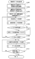
次に、本実施の形態のナビゲーション装置100の動作について説明する。
Next, the operation of the
図4において、まず、ユーザが入力手段101を操作することにより、車両の出発地および目的地が入力される(ステップS401)。次いで、演算処理手段110の情報取得部202および地図情報取得部203により、車両を出発地から目的地まで案内する地図情報が情報判定手段109から読み出され取得される(ステップS402)。ここで、地図情報取得部203は、案内情報記憶手段103および配信情報記憶手段108に記憶された案内情報の内、新しい案内情報を取得する。なお、情報センタから配信された配信情報が配信情報記憶手段108に記憶されるステップについては後述する。引き続き、演算処理手段110の経路選出部205により、案内経路が探索される(ステップS403)。そして、演算処理手段110の経路誘導部206により、車両の出発地から目的地までの案内経路の誘導案内が行われる(ステップS404)。
In FIG. 4, first, the user operates the input means 101 to input the starting point and the destination of the vehicle (step S401). Next, the map information for guiding the vehicle from the departure point to the destination is read out and acquired from the
次に、図5を参照して、本実施の形態のナビゲーション装置100が情報センタから配信される配信情報を要求してから配信情報記憶手段108に記憶するまでのステップを説明する。
Next, steps from when the
図5において、まず、配信情報要求手段104により、配信情報が要求される(ステップS501)。次いで、配信情報受信手段105により、情報センタから配信された配信情報が受信される(ステップS502)。引き続き、配信情報解析手段106により、配信情報受信手段105により受信された配信情報が解析される(ステップS503)。さらに、探索用データ作成手段107により、案内経路の探索時に参照される探索用データが作成される(ステップS504)。そして、配信情報記憶手段108により、解析された配信情報および探索用データが記憶される(ステップS505)。
In FIG. 5, first, distribution information is requested by the distribution information request means 104 (step S501). Next, the distribution information receiving means 105 receives the distribution information distributed from the information center (step S502). Subsequently, the distribution
なお、前述の図4に示されたステップS402において、配信情報記憶手段108から配信情報に含まれる地図情報を取得するときに、上記のステップS501からステップS505までのステップを実行するよう構成してもよいし、情報センタから随時、または、定期的に配信情報を受信し、上記ステップS501からステップS505までのステップを実行するよう構成してもよい。また、案内情報記憶手段103に記憶されている案内情報を参照し、この案内情報よりも新しい案内情報を配信情報受信手段105により受信し、配信情報記憶手段108に記憶するように構成してもよい。
In step S402 shown in FIG. 4 described above, when the map information included in the distribution information is acquired from the distribution information storage means 108, the above steps S501 to S505 are executed. Alternatively, the distribution information may be received from the information center at any time or periodically, and the steps from step S501 to step S505 may be executed. Further, the guide information stored in the guide
次に、全ノード隣接接続判定部208によって実行される全ノード隣接接続判定処理について、図6を参照して説明する。
Next, the all-node adjacent connection determination process executed by the all-node adjacent
図6において、まず、取得した地図データのエリア内に関して、ノード属性および座標情報からエリアの境界上にある全ての隣接ノードが検出され、対象候補ノードとされる(ステップS601)。次いで、対象候補ノードの内、未選択のものがひとつ選択される(ステップS602)。さらに、選択された隣接ノードに接続しているリンクが探索対象であるか否かが判定される(ステップS603)。ステップS603において、選択された隣接ノードに接続しているリンクが探索対象であると判定された場合は、後述の特定ノード隣接接続判定処理が実行され(ステップS604)、選択された隣接ノードに関しての隣接接続情報が求められる。 In FIG. 6, first, regarding the area of the acquired map data, all adjacent nodes on the boundary of the area are detected from the node attribute and coordinate information, and are set as target candidate nodes (step S601). Next, an unselected one of the target candidate nodes is selected (step S602). Further, it is determined whether or not the link connected to the selected adjacent node is a search target (step S603). When it is determined in step S603 that the link connected to the selected adjacent node is a search target, a specific node adjacent connection determination process described later is executed (step S604), and Neighbor connection information is required.
一方、ステップS603において、選択された隣接ノードに接続しているリンクが探索対象であると判定されなかった場合は、選択されていない対象候補となる隣接ノードが存在する否かが判定される(ステップS605)。 On the other hand, if it is not determined in step S603 that the link connected to the selected adjacent node is a search target, it is determined whether there is an adjacent node that is a target candidate that is not selected ( Step S605).
ステップS605において、選択されていない隣接ノードが存在すると判定された場合は、ステップS602に戻る。一方、ステップS605において、選択されていない隣接ノードが存在すると判定されなかった場合は、全ノード隣接接続判定処理を終了する。 If it is determined in step S605 that there is an adjacent node that has not been selected, the process returns to step S602. On the other hand, if it is not determined in step S605 that there is an unselected adjacent node, the all-node adjacent connection determination process ends.
次に、前述のステップS604における特定ノード隣接接続判定処理について、図7を参照して説明する。 Next, the specific node adjacent connection determination process in step S604 described above will be described with reference to FIG.
図7において、まず、特定の隣接ノードから距離α(例えばα=50m)となる領域が決定され、この領域に含まれる範囲が特定される(ステップS701)。次いで、未選択の隣接範囲が選択される(ステップS702)。ここで、未選択の隣接範囲を含む地図データがメモリ上にないときは、該当する地図データが取得される。さらに、選択された隣接範囲内に特定の隣接ノードから距離α以下となる隣接ノードがあるか否かが判定される(ステップS703)。ステップS703において、該当する隣接ノードが存在すると判定された場合は、隣接候補ノードとされる(ステップS704)。 In FIG. 7, first, an area having a distance α (for example, α = 50 m) from a specific adjacent node is determined, and a range included in this area is specified (step S701). Next, an unselected adjacent range is selected (step S702). Here, when there is no map data including an unselected adjacent range in the memory, the corresponding map data is acquired. Further, it is determined whether or not there is an adjacent node that is within a distance α from the specific adjacent node in the selected adjacent range (step S703). If it is determined in step S703 that the corresponding adjacent node exists, it is determined as an adjacent candidate node (step S704).
一方、ステップS703において、該当する隣接ノードが存在すると判定されなかった場合は、未選択の隣接範囲が存在するか否かが判定される(ステップS705)。ステップS705において、未選択の隣接範囲が存在すると判定された場合は、ステップS702に戻り、未選択の隣接範囲が存在すると判定されなかった場合は、複数の隣接候補ノードから接続されている可能性が高いノードが選択される隣接接続判定処理を実行し(ステップS706)、特定ノード隣接接続判定処理を終了する。 On the other hand, if it is not determined in step S703 that the corresponding adjacent node exists, it is determined whether there is an unselected adjacent range (step S705). If it is determined in step S705 that there is an unselected adjacent range, the process returns to step S702. If it is not determined that an unselected adjacent range exists, there is a possibility that a plurality of adjacent candidate nodes are connected. An adjacent connection determination process in which a node having a higher value is selected is executed (step S706), and the specific node adjacent connection determination process is terminated.
次に、前述のステップS706における隣接接続判定処理について、図8を参照して説明する。 Next, the adjacent connection determination process in step S706 described above will be described with reference to FIG.
図8において、まず、隣接候補ノードが存在するか否かが判定され(ステップS801)、隣接候補ノードが存在すると判定されなかった場合は接続できないと判定され(ステップS810)、隣接接続判定処理を終了する。一方、隣接候補ノードが存在すると判定された場合は、境界前後で道路種別、例えば、高速道、国道、県道等の種別が一致するか否かが判断される(ステップS802)。 In FIG. 8, it is first determined whether or not there is an adjacent candidate node (step S801). If it is not determined that there is an adjacent candidate node, it is determined that connection is not possible (step S810), and the adjacent connection determination process is performed. finish. On the other hand, if it is determined that there is an adjacent candidate node, it is determined whether or not the road type, for example, the type of highway, national road, prefectural road, etc., matches before and after the boundary (step S802).
ステップS802において、道路種別が一致すると判定されなかった場合は、前述のステップS810の処理後、隣接接続判定処理を終了する。一方、道路種別が一致すると判定された場合は、相手側の隣接ノードが一意に特定できるか否かが判定される(ステップS803)。 If it is not determined in step S802 that the road types match, the adjacent connection determination process ends after the process in step S810 described above. On the other hand, if it is determined that the road types match, it is determined whether or not the partner adjacent node can be uniquely identified (step S803).
ステップS803において、相手側の隣接ノードが一意に特定できると判定された場合は、該当の隣接ノードの接続されたリンク同士は接続できると判定されるとともに、この隣接接続関係が記録され(ステップS811)、隣接接続判定処理を終了する。一方、ステップS803において、相手側の隣接ノードが一意に特定できると判定されなかった場合は、境界前後でリンク種別、例えば、本線、側道、ジャンクション等の種別が一致するか否かが判定される(ステップS804)。 If it is determined in step S803 that the adjacent node on the other side can be uniquely identified, it is determined that the links connected to the corresponding adjacent node can be connected to each other, and this adjacent connection relationship is recorded (step S811). ), The adjacent connection determination process is terminated. On the other hand, if it is not determined in step S803 that the partner adjacent node can be uniquely identified, it is determined whether or not the link types, for example, main line, side road, junction, and the like match before and after the boundary. (Step S804).
ステップS804において、リンク種別が一致すると判定されなかった場合は、前述のステップS810の処理後、隣接接続判定処理を終了する。一方、ステップS804において、リンク種別が一致すると判定された場合は、相手側の隣接ノードが一意に特定できるか否かが判定される(ステップS805)。 If it is not determined in step S804 that the link types match, the adjacent connection determination process ends after the process in step S810 described above. On the other hand, if it is determined in step S804 that the link types match, it is determined whether or not the partner adjacent node can be uniquely identified (step S805).
ステップS805において、相手側の隣接ノードが一意に特定できると判定された場合は、前述のステップS811の処理後、隣接接続判定処理を終了する。一方、ステップS805において、相手側の隣接ノードが一意に特定できると判定されなかった場合は、境界前後で一方通行情報が一致するか否かが判定される(ステップS806)。 If it is determined in step S805 that the partner adjacent node can be uniquely identified, the adjacent connection determination process ends after the process in step S811 described above. On the other hand, if it is not determined in step S805 that the partner adjacent node can be uniquely identified, it is determined whether the one-way information matches before and after the boundary (step S806).
ステップS806において、一方通行情報が一致すると判定されなかった場合は、前述のステップS810の処理後、隣接接続判定処理を終了する。一方、ステップS806において、一方通行情報が一致すると判定された場合は、相手側の隣接ノードが一意に特定できるか否かが判定される(ステップS807)。 If it is not determined in step S806 that the one-way information matches, the adjacent connection determination process ends after the process in step S810 described above. On the other hand, if it is determined in step S806 that the one-way information matches, it is determined whether or not the adjacent node on the other side can be uniquely identified (step S807).
ステップS807において、相手側の隣接ノードが一意に特定できると判定された場合は、前述のステップS811の処理後、隣接接続判定処理を終了する。一方、ステップS807において、相手側の隣接ノードが一意に特定できると判定されなかった場合は、境界前後でリンクの角度差がβ以下(例えばβ=10度)であるか否かが判定される(ステップS808)。 If it is determined in step S807 that the adjacent node on the other side can be uniquely identified, the adjacent connection determination process is terminated after the process in step S811 described above. On the other hand, if it is not determined in step S807 that the partner adjacent node can be uniquely identified, it is determined whether the link angle difference before and after the boundary is equal to or less than β (for example, β = 10 degrees). (Step S808).
ステップS808において、リンクの角度差がβ以下であると判定されなかった場合は、前述のステップS810の処理後、隣接接続判定処理を終了する。一方、ステップS808において、リンクの角度差がβ以下であると判定された場合は、相手側の隣接ノードが一意に特定できるか否かが判定される(ステップS809)。 If it is not determined in step S808 that the link angle difference is equal to or less than β, the adjacent connection determination process ends after the process in step S810 described above. On the other hand, if it is determined in step S808 that the link angle difference is equal to or less than β, it is determined whether or not the partner adjacent node can be uniquely identified (step S809).
ステップS809において、相手側の隣接ノードが一意に特定できると判定された場合は、前述のステップS811の処理後、隣接接続判定処理を終了する。一方、ステップS809において、相手側の隣接ノードが一意に特定できると判定されなかった場合は、前述のステップS810の処理後、隣接接続判定処理を終了する。 If it is determined in step S809 that the adjacent node on the other side can be uniquely specified, the adjacent connection determination process is terminated after the process in step S811 described above. On the other hand, if it is not determined in step S809 that the adjacent node on the other side can be uniquely identified, the adjacent connection determination process ends after the process in step S810 described above.
以上説明したように、全ノード隣接接続判定部208により、配信情報受信手段105を介して受信された地図データのエリアと案内情報記憶手段103に予め記憶された地図データのエリアとの境界上における隣接ノードに接続されたリンクがそれぞれ接続できるか否かが判定される。
As described above, on the boundary between the area of the map data received via the distribution information receiving means 105 and the area of the map data stored in advance in the guidance information storage means 103 by the all-node adjacent
次に、探索用データ作成手段107について詳細に説明する。探索用データ作成手段107は、案内経路の探索の高速化を実現するため、配信された地図データに基づき、より巨視的に、より広い道路網のデータを作成する処理を行うようになっている。なお、以下の説明においては、理解の便宜上、1階層の地図データを対象とし、主要道路以上の道路のみ記録して探索用データを作成することを想定している。この地図データの階層は、複数の階層で作成する構成にしてもよい。 Next, the search data creation means 107 will be described in detail. The search data creation means 107 performs a process for creating data of a wider road network on a macroscopic basis based on the distributed map data in order to speed up the search for the guide route. . In the following description, for the sake of understanding, it is assumed that the search data is created by recording only one or more major roads with map data of one layer as a target. The map data layer may be created by a plurality of layers.
図9は、探索用データ作成手段107により作成された探索用データの一例を示しており、図9(a)は探索用データの作成範囲の一例、図9(b)は探索用データの管理情報の一例、図9(c)は探索用データの構成データの一例を示している。 FIG. 9 shows an example of search data created by the search data creation means 107, FIG. 9A shows an example of the search data creation range, and FIG. 9B shows search data management. An example of the information, FIG. 9C shows an example of the configuration data of the search data.
図9(a)に示すように、本実施の形態においては、予め定められた範囲のエリアの地図ユニットを一定数、例えば、8×8ユニットにまとめた範囲を探索用データの作成範囲としており、図9(a)に示された探索用データ901は、行および列によって位置が示された地図ユニット(0,0)から地図ユニット(7,7)までの64個の地図ユニットにより構成されている。
As shown in FIG. 9A, in the present embodiment, the search data creation range is a range in which a predetermined number of map units in an area in a predetermined range, for example, 8 × 8 units are grouped. The
探索用データ901の情報は、図9(b)に示すような管理テーブルにより、地図ユニット毎に管理されている。各地図ユニットは、地図ユニット毎に予め定められた基準点の緯度、経度、先頭アドレス、ファイルサイズ等の情報が記録され管理されている。この情報を記録した一例を図9(c)に示す。図9(c)に示された探索用データは、少なくとも探索処理を実行するための最小限の道路網情報、例えば、ノード情報902、リンク情報903等の情報を含んでいる。図9(b)に示すように、各地図ユニットの情報が、探索用データ内の何処に記録されているか管理する管理情報を作成することにより、更新された地図ユニットが配信されたときに、配信された地図ユニット内のみ探索用データを作成し直し、元の探索用データの記録位置に埋め込むことができるので、探索用データを短時間で作成することができる。
Information of the
次に、探索用データ作成手段107の動作について、図10を参照して説明する。
Next, the operation of the search
図10において、まず、更新された地図ユニットから未選択の地図ユニットが選択される(ステップS1001)。次いで、選択された地図ユニットを含む探索用データが読み込まれる(ステップS1002)。さらに、読み込まれた探索用データの内、該当地図ユニットに関する情報の記録領域がクリアされる(ステップS1003)。そして、該当地図ユニットに含まれる未選択のノードが選択され(ステップS1004)、記録対象ノードか否かを判定するため、後述の記録対象ノード判定処理を実行する(ステップS1005)。 In FIG. 10, first, an unselected map unit is selected from the updated map units (step S1001). Next, search data including the selected map unit is read (step S1002). Furthermore, the recording area of the information regarding the corresponding map unit is cleared in the read search data (step S1003). Then, an unselected node included in the corresponding map unit is selected (step S1004), and a recording target node determination process described later is executed to determine whether or not the node is a recording target node (step S1005).
引き続き、選択されたノードが記録対象か否かが判定される(ステップS1006)。ステップS1006において、選択されたノードが記録対象と判定された場合は、選択されたノードが記録対象ノードとされて記録され(ステップS1007)、ノードが全て調査されたか否かが判定される(ステップS1008)。一方、ステップS1006において、選択されたノードが記録対象と判定されなかった場合は、前述のステップS1008に進む。 Subsequently, it is determined whether or not the selected node is a recording target (step S1006). If it is determined in step S1006 that the selected node is a recording target, the selected node is recorded as a recording target node (step S1007), and it is determined whether all the nodes have been investigated (step S1006). S1008). On the other hand, if it is determined in step S1006 that the selected node is not a recording target, the process proceeds to step S1008 described above.
ステップS1008において、ノードが全て調査されたと判定された場合は、未選択の記録対象ノードが選択される(ステップS1009)。ステップS1008において、ノードが全て調査されたと判定されなかった場合は、ステップS1004に戻る。 If it is determined in step S1008 that all nodes have been examined, an unselected recording target node is selected (step S1009). If it is not determined in step S1008 that all nodes have been investigated, the process returns to step S1004.
続いて、後述のデータ生成処理が実行され(ステップS1010)、探索用データが作成される。そして、記録対象ノードが全て調査されたか否かが判定され(ステップS1011)、記録対象ノードが全て調査されたと判定された場合は、探索用データ作成処理を終了し、記録対象ノードが全て調査されたと判定されなかった場合は、ステップS1009に戻る。なお、更新された地図が複数の場合は、図10の処理を繰り返せばよい。また、地図のバージョンが同一の地図に対して実施してもよい。 Subsequently, a data generation process to be described later is executed (step S1010), and search data is created. Then, it is determined whether or not all the recording target nodes have been investigated (step S1011). If it is determined that all the recording target nodes have been investigated, the search data creation process is terminated, and all the recording target nodes are investigated. If it is not determined that the process has been performed, the process returns to step S1009. In addition, what is necessary is just to repeat the process of FIG. 10, when there are two or more updated maps. Moreover, you may implement with respect to the map with the same map version.
次に、前述のステップS1005における記録対象ノード判定処理について、図11を参照して説明する。 Next, the recording target node determination process in step S1005 will be described with reference to FIG.
図11において、まず、選択されたノードが隣接ノードか否かが判定される(ステップS1101)。ステップS1101において、選択されたノードが隣接ノードと判定された場合は、当該隣接ノードに接続されるリンクが選択され(ステップS1111)、選択された接続リンクが記録対象か否か判定される(ステップS1112)。なお、本実施例においては、前述のように道路種別が主要道以上の道路を記録対象としている。 In FIG. 11, first, it is determined whether or not the selected node is an adjacent node (step S1101). If it is determined in step S1101 that the selected node is an adjacent node, a link connected to the adjacent node is selected (step S1111), and it is determined whether the selected connection link is a recording target (step S1111). S1112). In the present embodiment, as described above, roads whose road type is a main road or higher are recorded.
ステップS1112において、選択された接続リンクが記録対象と判定された場合は、記録対象と判定され、記録対象リンク数が記録され(ステップS1110)、記録対象ノード判定処理を終了する。一方、ステップS1112において、選択された接続リンクが記録対象と判定されなかった場合は、記録対象外と判定され(ステップS1113)、記録対象ノード判定処理を終了する。 If it is determined in step S1112 that the selected connection link is a recording target, it is determined as a recording target, the number of recording target links is recorded (step S1110), and the recording target node determination process is terminated. On the other hand, if the selected connection link is not determined to be a recording target in step S1112, it is determined that the selected connection link is not a recording target (step S1113), and the recording target node determination process ends.
ステップS1101において、選択されたノードが隣接ノードと判定されなかった場合は、記録対象リンク数が初期化される(ステップS1102)。次いで、選択されたノードに接続しているリンクの内、未選択のものが選択される(ステップS1103)。さらに、選択された接続リンクが記録対象か否かが判定され(ステップS1104)、選択された接続リンクが記録対象と判定された場合は、記録対象リンク数がひとつインクリメントされ(ステップS1105)、選択されたノードに接続しているリンクが全て調査されたか否かが判定される(ステップS1106)。前述のステップS1104において、選択された接続リンクが記録対象と判定されなかった場合は、ステップS1106に進む。 If the selected node is not determined to be an adjacent node in step S1101, the number of recording target links is initialized (step S1102). Next, an unselected link is selected from the links connected to the selected node (step S1103). Further, it is determined whether or not the selected connection link is a recording target (step S1104). If the selected connection link is determined to be a recording target, the number of recording target links is incremented by one (step S1105) and selected. It is determined whether all the links connected to the selected node have been investigated (step S1106). If it is determined in step S1104 described above that the selected connection link is not a recording target, the process advances to step S1106.
ステップS1106において、選択されたノードに接続しているリンクが全て調査されたと判定された場合は、記録対象リンク数が0本か否かが判定される(ステップS1107)。一方、ステップS1106において、選択されたノードに接続しているリンクが全て調査されたと判定されなかった場合は、ステップS1103に戻る。 If it is determined in step S1106 that all links connected to the selected node have been investigated, it is determined whether the number of recording target links is zero (step S1107). On the other hand, if it is not determined in step S1106 that all the links connected to the selected node have been investigated, the process returns to step S1103.
ステップS1107において、記録対象リンク数が0本と判定された場合は、前述のステップS1113の処理後、記録対象ノード判定処理を終了する。一方、ステップS1107において、記録対象リンク数が0本と判定されなかった場合は、記録対象リンク数が2本か否かが判定される(ステップS1108)。 If it is determined in step S1107 that the number of recording target links is zero, the recording target node determination processing is terminated after the processing in step S1113 described above. On the other hand, if it is determined in step S1107 that the number of recording target links is not zero, it is determined whether or not the number of recording target links is two (step S1108).
ステップS1108において、記録対象リンク数が2本と判定されなかった場合は、前述のステップS1110に進み、記録対象と判定して記録対象リンク数を記録した後、記録対象ノード判定処理を終了する。一方、ステップS1108において、記録対象リンク数が2本と判定された場合は、2本の記録対象リンクのリンク属性が同一か否かが判定される(ステップS1109)。 If it is determined in step S1108 that the number of recording target links is not two, the process proceeds to step S1110 described above. After determining the recording target and recording the number of recording target links, the recording target node determination processing ends. On the other hand, if it is determined in step S1108 that the number of recording target links is two, it is determined whether or not the link attributes of the two recording target links are the same (step S1109).
ステップS1109において、2本の記録対象リンクのリンク属性が同一と判定された場合は、前述のステップS1113の処理後、記録対象ノード判定処理を終了する。一方、ステップS1109において、2本の記録対象リンクのリンク属性が同一と判定されなかった場合は、属性変化点と判定され、ステップS1110の処理後、記録対象ノード判定処理を終了する。なお、ステップS1109の処理により、単純な2差路ノードが削減できるので、探索対象となるリンク数自体も削減することができる。 If it is determined in step S1109 that the link attributes of the two recording target links are the same, the recording target node determination process ends after the process of step S1113 described above. On the other hand, if it is determined in step S1109 that the link attributes of the two recording target links are not the same, it is determined as an attribute change point, and after the process of step S1110, the recording target node determination process ends. Note that the processing in step S1109 can reduce the number of simple two-way nodes, and thus the number of links to be searched can be reduced.
次に、図10に示されたステップS1010におけるデータ生成処理について、図12を参照して説明する。 Next, the data generation processing in step S1010 shown in FIG. 10 will be described with reference to FIG.
図12において、まず、選択されたノードが隣接ノードか否かが判定される(ステップS1201)。ステップS1201において、選択されたノードが隣接ノードと判定された場合は、後述の境界接続データ生成処理を実行し(ステップS1202)、選択ノードに接続された未選択の記録対象リンクが選択される(ステップS1203)。なお、境界接続データ生成処理とは、探索時に隣接ノードの接続判定を高速化するため、予め隣接接続関係を示すデータを作成する処理をいう。一方、ステップS1201において、選択されたノードが隣接ノードと判定されなかった場合は、ステップS1203に進む。 In FIG. 12, first, it is determined whether or not the selected node is an adjacent node (step S1201). When it is determined in step S1201 that the selected node is an adjacent node, boundary connection data generation processing described later is executed (step S1202), and an unselected recording target link connected to the selected node is selected (step S1202). Step S1203). The boundary connection data generation process refers to a process for creating data indicating an adjacent connection relationship in advance in order to speed up the connection determination of adjacent nodes during a search. On the other hand, if it is determined in step S1201 that the selected node is not an adjacent node, the process proceeds to step S1203.
引き続き、リンク属性が累積され、新たなリンク属性が生成される(ステップS1204)。例えば、今までのリンク属性の累積リンク長が90で、選択した記録対象リンクのリンク長が10であれば、新たなリンク属性の累積リンク長は100となる。次いで、記録対象リンクの相手側ノードが取得され(ステップS1205)、相手側ノードが記録対象ノードか否かが判定される(ステップS1206)。 Subsequently, the link attributes are accumulated and a new link attribute is generated (step S1204). For example, if the cumulative link length of the link attribute so far is 90 and the link length of the selected recording target link is 10, the cumulative link length of the new link attribute is 100. Next, the counterpart node of the recording target link is acquired (step S1205), and it is determined whether the counterpart node is a recording target node (step S1206).
ステップS1206において、相手側ノードが記録対象ノードと判定されなかった場合は、ノード属性から新たなリンク属性が生成される(ステップS1207)。例えば、ノード通行規制、右左折コスト等のノードコストの内容がリンク属性に反映される。次いで、相手側ノードが基点とされ、もう一方の記録対象リンクが選択され(ステップS1208)、ステップS1204に戻る。 If it is determined in step S1206 that the counterpart node is not a recording target node, a new link attribute is generated from the node attribute (step S1207). For example, the contents of node costs such as node traffic restrictions and right / left turn costs are reflected in the link attributes. Next, the counterpart node is used as a base point, the other recording target link is selected (step S1208), and the process returns to step S1204.
一方、ステップS1206において、相手側ノードが記録対象ノードと判定された場合は、当該選択ノードと相手側ノード間とのリンク属性として、新たなリンク属性が記録される(ステップS1209)。そして、未選択の記録対象リンクがあるか否かが判定され(ステップS1210)、未選択の記録対象リンクがあると判断された場合は、ステップS1203に戻り、未選択の記録対象リンクがあると判断されなかった場合は、データ生成処理を終了する。 On the other hand, if it is determined in step S1206 that the counterpart node is a recording target node, a new link attribute is recorded as a link attribute between the selected node and the counterpart node (step S1209). Then, it is determined whether or not there is an unselected recording target link (step S1210). If it is determined that there is an unselected recording target link, the process returns to step S1203, and if there is an unselected recording target link. If not determined, the data generation process is terminated.
以上説明したように、探索用データ作成手段107により、広範囲の探索用データを作成し、隣接地図データを取得する際に当該探索用データを参照することにより、探索する対象リンクを削減できるので、探索時間を短縮することができる。 As described above, the search data creation means 107 creates a wide range of search data, and by referring to the search data when acquiring adjacent map data, the target links to be searched can be reduced. Search time can be shortened.
次に、前述のステップS1202における境界接続データ生成処理について詳述する。本処理により、探索時に隣接ノードの接続判定を高速化することができる隣接関係を表すデータが作成される。 Next, the boundary connection data generation process in step S1202 will be described in detail. By this processing, data representing an adjacent relationship that can speed up the connection determination of adjacent nodes at the time of search is created.
図13において、まず、探索用データ同士の境界か否かが判定される(ステップS1301)。ステップS1301において、探索用データ同士の境界と判定されなかった場合は、隣接範囲が同じ探索用データ内の隣接地図レコードとされ(ステップS1305)、前述の特定ノード隣接接続判定処理を実行し(ステップS1306)、境界接続データ生成処理を終了する。本処理により、探索用データ内部の隣接関係の対応関係を表すリストが作成されることとなり、図14を参照して説明する。 In FIG. 13, first, it is determined whether or not the boundary is between search data (step S1301). If it is not determined in step S1301 that the boundary is between the search data, the adjacent range is set as an adjacent map record in the same search data (step S1305), and the specific node adjacent connection determination process described above is executed (step S1301). In step S1306, the boundary connection data generation process ends. With this processing, a list representing the correspondence relationship between the adjacent relationships in the search data is created, which will be described with reference to FIG.
図14(a)は、探索用データA1401と探索用データB1402との境界接続データの一例を示している。探索用データA1401および探索用データB1402は、行および列によって位置が示された地図ユニット(0,0)から地図ユニット(7,7)までの64個の地図ユニットにより構成されており、探索用データA1401の地図ユニット(7,4)の境界上にあるノードA1403と、探索用データB1402の地図ユニット(0,4)の境界上にあるノードB1404と、探索用データB1402の地図ユニット(5,2)の境界上にあるノードC1405と、探索用データB1402の地図ユニット(6,2)の境界上にあるノードD1406とが示されている。図14(b)は、探索用データA1401および探索用データB1402の環境接続データを示している。前述のステップS1305およびステップS1306において作成されデータは、図14(b)に示されたノードC1405とノードD1406との関係を表した情報のように、同一の探索用データ内部における接続関係を表したデータである。
FIG. 14A shows an example of boundary connection data between the search data A1401 and the search data B1402. Search data A1401 and search data B1402 are composed of 64 map units from map unit (0,0) to map unit (7,7) whose positions are indicated by rows and columns. A node A 1403 on the boundary of the map unit (7, 4) of the
図13に示されたステップS1301において、探索用データ同士の境界と判定された場合は、隣接範囲が隣接地図データとされ(ステップS1302)、前述の特定ノード隣接接続判定処理が実行される(ステップS1303)。本処理により、地図データと探索用データとの隣接関係の対応関係を表すリストが作成されることとなり、図15を参照して説明する。 If it is determined in step S1301 shown in FIG. 13 that the boundary is between search data, the adjacent range is set as adjacent map data (step S1302), and the above-described specific node adjacent connection determination process is executed (step S1302). S1303). With this processing, a list representing the correspondence relationship between the map data and the search data is created, which will be described with reference to FIG.
図15(a)は、地図データ群C1501に含まれる地図データ(7,4)と探索用データD1502との境界接続データの一例を示している。地図データ群C1501は、行および列によって位置が示された地図データ(0,0)から地図データ(7,7)までの64個の地図データにより構成されている。また、探索用データD1502は、行および列によって位置が示された地図ユニット(0,0)から地図ユニット(7,7)までの64個の地図ユニットにより構成されている。ここで、探索用データDに記録される道路網は、地図データ群Cに記録された道路図のうち、主要なもののみで構成されている。 FIG. 15A shows an example of boundary connection data between the map data (7, 4) included in the map data group C1501 and the search data D1502. The map data group C1501 is composed of 64 pieces of map data from map data (0, 0) to map data (7, 7) whose positions are indicated by rows and columns. The search data D1502 includes 64 map units from a map unit (0, 0) to a map unit (7, 7) whose positions are indicated by rows and columns. Here, the road network recorded in the search data D is composed of only major road maps recorded in the map data group C.
図15(a)には、地図データ群C1501に含まれる地図データ(7,4)の境界上にあるノードE1503と、探索用データD1502の地図ユニット(0,4)の境界上にあるノードF1504とが示されている。図15(b)は、地図データ群C1501に含まれる地図データ(7,4)および探索用データD1502の環境接続データを示している。前述のステップS1302およびステップS1303において作成されデータは、図15(b)に示されたノードE1503とノードF1504との関係を表した情報のように、地図データと探索用データとの接続関係を表したデータである。 FIG. 15A shows a node E1503 on the boundary of the map data (7, 4) included in the map data group C1501 and a node F1504 on the boundary of the map unit (0, 4) of the search data D1502. Is shown. FIG. 15B shows environment connection data of map data (7, 4) and search data D1502 included in the map data group C1501. The data created in steps S1302 and S1303 described above represents the connection relationship between the map data and the search data, like the information representing the relationship between the node E1503 and the node F1504 shown in FIG. Data.
引き続き、隣接範囲が隣接探索用データとされ(ステップS1304)、前述の特定ノード隣接接続判定処理が実行され(ステップS1306)、境界接続データ生成処理を終了する。本処理により、探索用データ同士の隣接関係の対応関係を記述するリストが作成されることとなる。上記のステップで作成されデータは、図14(b)に示されたノードA1403とノードB1404との関係を表した情報のように探索用データ同士の接続関係を表したデータである。 Subsequently, the adjacent range is set as adjacent search data (step S1304), the above-described specific node adjacent connection determination process is executed (step S1306), and the boundary connection data generation process ends. By this processing, a list describing the correspondence relationship of the adjacent relationship between the search data is created. The data created in the above steps is data representing the connection relationship between the search data like the information representing the relationship between the node A 1403 and the node B 1404 shown in FIG.
なお、図14(b)および図15(b)に示された境界接続データは、一方からの接続関係、例えば、ノードA1403からノードB1404の方向だけでなく、逆方向の接続関係であるノードB1404からノードA1403の方向を記録するようにしてもよいし、双方からの接続関係を記録してもよい。また、記録する情報は、ノードが特定できればどのような内容でもよい。また、図14(b)の場合、同一探索用データ内の境界接続データと隣接する探索用データ間の境界接続データとを分けて記録してもよい。さらに、ノードが属する地図毎に分けて記録してもよい。 Note that the boundary connection data shown in FIG. 14B and FIG. 15B is not only the connection relationship from one side, for example, the node B 1404 that is not only the direction from the node A 1403 to the node B 1404 but also the reverse connection relationship. The direction of the node A 1403 may be recorded, or the connection relationship from both may be recorded. The information to be recorded may be any content as long as the node can be specified. In the case of FIG. 14B, boundary connection data in the same search data and boundary connection data between adjacent search data may be recorded separately. Furthermore, it may be recorded separately for each map to which the node belongs.
以上のように、本実施の形態のナビゲーション装置によれば、全ノード隣接接続判定部208により、境界上に存在する全ノードにそれぞれ接続されたリンク同士が接続できるか否か判定する構成としたので、この判定結果に基づいて隣接した地図データを接続することができ、接続された地図データにより、最適な案内経路の探索および誘導案内を行うことができる。
As described above, according to the navigation device of the present embodiment, the all-node adjacent
(第2の実施の形態)
まず、本発明の第2の実施の形態の地図データ接合装置を備えたナビゲーション装置の構成について説明する。図16に示すように、本実施の形態のナビゲーション装置1600は、ユーザが車両の出発地および目的地等の情報を入力する入力手段1601と、車両の現在位置を検出する車両位置検出手段1602と、図示していない情報センタが配信する配信情報を情報センタに要求する配信情報要求手段1603と、情報センタが配信する配信情報を受信する配信情報受信手段1604と、配信情報受信手段1604により受信された配信情報を解析する配信情報解析手段1605と、配信情報解析手段1605により解析された配信情報および後述の案内情報記憶手段1608に記憶された案内情報に基づいて案内経路の探索用データを作成する探索用データ作成手段1606と、配信情報解析手段1605により解析された配信情報に基づいて案内情報記憶手段1608に記憶された案内情報を更新する案内情報更新手段1607と、配信情報の解析結果および探索用データを記憶する案内情報記憶手段1608と、車両の誘導案内に係る情報を処理する演算処理手段1609と、演算処理手段1609により処理された情報に基づいて提示情報を作成する提示情報作成手段1610と、提示情報を提示する情報提示手段1611とを備えている。
(Second Embodiment)
First, the structure of the navigation apparatus provided with the map data joining apparatus of the 2nd Embodiment of this invention is demonstrated. As shown in FIG. 16, the
以下の構成の説明において、本発明の第1の実施の形態のナビゲーション装置100と同じ構成については、その説明を省略する。
In the following description of the configuration, the description of the same configuration as that of the
案内情報更新手段1607は、CPU、RAM、ROM等で構成され、案内情報記憶手段1608に記憶された案内情報を更新するようになっている。例えば、配信情報受信手段1604により、あるエリアの地図データが受信されたとき、この地図データが案内情報記憶手段1608に記憶された該当エリアの地図データよりも新しいときは、案内情報更新手段1607により、案内情報記憶手段1608に記憶された該当地図データが更新される。なお、案内情報更新手段1607は、地図データ更新手段を構成している。
The guide
案内情報記憶手段1608は、例えば、磁気ディスク、光ディスク、半導体メモリ等を備え、交差点および道路の接続状況、座標、形状、属性、規制情報等の道路網に関する地図情報、地点設定を行うための索引情報等、ナビゲーションに必要となる各種情報を記憶するようになっている。また、探索用データ作成手段1606により作成された探索用データが記憶されるようになっている。 The guide information storage means 1608 includes, for example, a magnetic disk, an optical disk, a semiconductor memory, and the like, and includes map information relating to road networks such as intersection and road connection status, coordinates, shape, attributes, and regulatory information, and an index for setting points. Various information necessary for navigation, such as information, is stored. Also, the search data created by the search data creation means 1606 is stored.
前述したように、本発明の第1の実施の形態のナビゲーション装置100においては、受信された配信情報は配信情報記憶手段108に記憶され、この情報と案内情報記憶手段103に記憶された情報との何れを利用するかを情報判定手段109により判定していたのに対し、本発明の第2の実施の形態のナビゲーション装置1600においては、受信された配信情報は、案内情報記憶手段1608に記憶される構成としている点が異なっている。すなわち、本発明の第2の実施の形態のナビゲーション装置1600においては、案内情報記憶手段1608により、最新の配信情報が案内情報として記憶されており、演算処理手段1609は、案内情報記憶手段1608により記憶された案内情報に基づいて案内経路の探索処理および誘導案内処理等を実行するようになっている。
As described above, in the
次に、演算処理手段1609の構成について、図17を参照して説明する。
Next, the configuration of the
図17において、本実施の形態の演算処理手段1609は、本発明の第1の実施の形態のナビゲーション装置100が備えた演算処理手段110の全ノード隣接接続判定部208に代えて特定ノード隣接接続判定部1708を備えている。したがって、特定ノード隣接接続判定部1708の構成を説明し、その他の構成の説明は省略する。
In FIG. 17, the
前述したように、本発明の第1の実施の形態のナビゲーション装置100が備えた全ノード隣接接続判定部208は、地図情報取得部203により地図情報が取得された場合、エリアの隣接境界部を通過するリンクに関して隣接地図と接続しているか否かを全ての境界通過リンクについて判定していたのに対し、本実施の形態では、特定ノード隣接接続判定部1708により、経路探索および車両の現在位置の計算時等に必要となった場合に、個別の特定ノードに関して、隣接地図データと接続しているか否かを判定するようにしている点が異なっている。例えば、予め距離閾値を設定しておき、車両の現在位置から走行中のエリアの境界上にあるノードまでの距離が距離閾値以内になったとき、特定ノード隣接接続判定部1708により、走行中のエリアと走行中のエリアに隣接したエリアとの接続関係を判定するようになっている。
As described above, when the map
なお、本発明の第2の実施の形態のナビゲーション装置1600の動作は、本発明の第1の実施の形態のナビゲーション装置100の動作において説明した図4に示されたステップと同じである。また、情報センタから配信された配信情報を受信してから記憶するまでのステップは、図5に示されたステップS503に続いて、案内情報更新手段1607による配信情報の更新ステップが実行される点が異なる。この配信情報の更新ステップは、案内情報更新手段1607により、配信された配信情報が案内情報記憶手段1608に記憶された情報よりも新しいときに更新されるものである。また、特定ノード隣接接続判定部1708による処理は、前述の図7に示された特定ノード隣接接続判定処理を示すフローチャートと同一であるので、その説明は省略する。
The operation of the
以上のように、本実施の形態のナビゲーション装置によれば、特定ノード隣接接続判定部1708により、境界上に存在する特定ノードにそれぞれ接続されたリンク同士が接続できるか否か判定する構成としたので、この判定結果に基づいて隣接した地図データを接続することができ、接続された地図データにより、最適な案内経路の探索および誘導案内を行うことができる。
As described above, according to the navigation device of the present embodiment, the specific node adjacent
なお、上述した本発明の第1および第2の実施の形態のナビゲーション装置に備えられた各手段および各部は、ハードウェアによる構成でもよいし、マイクロコンピュータのマルチタスク等のプログラム処理の結果としての構成でもよい。 Each means and each part provided in the navigation device of the first and second embodiments of the present invention described above may be configured by hardware or as a result of program processing such as multitasking of a microcomputer. It may be configured.
また、前述の各ステップの処理をプログラミングし、このプログラムをフロッピー(登録商標)ディスク等の記憶媒体に記憶させて移送することにより、独立した他のコンピュータシステムで容易に実施することができる。この場合、記憶媒体は、フロッピー(登録商標)ディスクに限らず、光ディスク、ICカード、ROMカセット等、プログラムを記憶できるものであればよい。 Further, by programming the processing of each step described above, storing this program in a storage medium such as a floppy (registered trademark) disk and transferring it, it can be easily implemented in another independent computer system. In this case, the storage medium is not limited to a floppy (registered trademark) disk, but may be any medium that can store a program, such as an optical disk, an IC card, or a ROM cassette.
また、本発明の第1の実施の形態における演算処理手段110と本発明の第2の実施の形態における演算処理手段1609とを入れ替えた構成としてもよい。 Further, the arithmetic processing means 110 in the first embodiment of the present invention and the arithmetic processing means 1609 in the second embodiment of the present invention may be replaced.
また、情報センタが配信情報を配信する形態には、ユーザの要求により配信情報が配信される通信型配信と、ユーザの要求の有無に関わらず常に配信している放送型配信があり、本発明のナビゲーション装置は、何れの配信形態にも対応するものである。 Further, the information center distributes the distribution information in a communication type distribution in which the distribution information is distributed according to a user's request and a broadcast type distribution in which the information center always distributes regardless of the user's request. This navigation apparatus is compatible with any distribution form.
100、1600 ナビゲーション装置
101、1601 入力手段
102、1602 車両位置検出手段
103、1608 案内情報記憶手段
104、1603 配信情報要求手段
105、1604 配信情報受信手段
106、1605 配信情報解析手段
107、1606 探索用データ作成手段
108 配信情報記憶手段
109 情報判定手段
110、1609 演算処理手段
111、1610 提示情報作成手段
112、1611 情報提示手段
1401 探索用データA
1402 探索用データB
1403 ノードA
1404 ノードB
1405 ノードC
1406 ノードD
1501 地図データ群C
1502 探索用データD
1503 ノードE
1504 ノードF
1607 案内情報更新手段
1708 特定ノード隣接接続判定部
201 処理選択部
202 情報取得部
203 地図情報取得部
204 位置計算部
205 経路選出部
206 経路誘導部
207 出力情報生成部
208 全ノード隣接接続判定部
301 第1のエリア
302 ノードA
303 ノードB
304 リンクA
305 リンクB
311 第2のエリア
312 ノードC
313 ノードD
314 リンクC
315 リンクD
901 探索用データ
902 ノード情報
903 リンク情報
100, 1600
1402 Search data B
1403 Node A
1404 Node B
1405 Node C
1406 Node D
1501 Map data group C
1502 Search data D
1503 Node E
1504 Node F
1607 Guidance
303 Node B
304 Link A
305 Link B
311
313 Node D
314 Link C
315 Link D
901
Claims (7)
配信された地図を用いてこの地図が対象とするエリアよりも広いエリアを対象とする広域道路網を作成する演算処理手段を備えるナビゲーション装置。 A navigation device having a map update function,
A navigation device comprising arithmetic processing means for creating a wide area road network for an area larger than an area targeted by the map using a distributed map.
配信された地図とこの地図が対象とするエリアよりも広いエリアを対象とする広域道路網との接続関係を作成する演算処理手段を備えるナビゲーション装置。 A navigation device having a map update function,
A navigation apparatus comprising arithmetic processing means for creating a connection relationship between a distributed map and a wide area road network that covers a larger area than the area targeted by the map.
Priority Applications (1)
| Application Number | Priority Date | Filing Date | Title |
|---|---|---|---|
| JP2006333135A JP2007121311A (en) | 2006-12-11 | 2006-12-11 | Map data joining device and navigation device |
Applications Claiming Priority (1)
| Application Number | Priority Date | Filing Date | Title |
|---|---|---|---|
| JP2006333135A JP2007121311A (en) | 2006-12-11 | 2006-12-11 | Map data joining device and navigation device |
Related Parent Applications (1)
| Application Number | Title | Priority Date | Filing Date |
|---|---|---|---|
| JP2003038430A Division JP2004245791A (en) | 2003-02-17 | 2003-02-17 | Map data joining device and navigation device |
Publications (1)
| Publication Number | Publication Date |
|---|---|
| JP2007121311A true JP2007121311A (en) | 2007-05-17 |
Family
ID=38145264
Family Applications (1)
| Application Number | Title | Priority Date | Filing Date |
|---|---|---|---|
| JP2006333135A Withdrawn JP2007121311A (en) | 2006-12-11 | 2006-12-11 | Map data joining device and navigation device |
Country Status (1)
| Country | Link |
|---|---|
| JP (1) | JP2007121311A (en) |
Cited By (1)
| Publication number | Priority date | Publication date | Assignee | Title |
|---|---|---|---|---|
| CN115145260A (en) * | 2021-03-30 | 2022-10-04 | 丰田自动车株式会社 | Data correction device, data correction method, data correction program, and vehicle |
-
2006
- 2006-12-11 JP JP2006333135A patent/JP2007121311A/en not_active Withdrawn
Cited By (2)
| Publication number | Priority date | Publication date | Assignee | Title |
|---|---|---|---|---|
| CN115145260A (en) * | 2021-03-30 | 2022-10-04 | 丰田自动车株式会社 | Data correction device, data correction method, data correction program, and vehicle |
| US12235128B2 (en) | 2021-03-30 | 2025-02-25 | Toyota Jidosha Kabushiki Kaisha | Data revision device, data revision method, data revision program, and vehicle |
Similar Documents
| Publication | Publication Date | Title |
|---|---|---|
| US9097553B2 (en) | Navigation based on direction of travel/user-defined path | |
| US8682576B2 (en) | Navigation based on user-defined points and paths | |
| JP4539776B2 (en) | Information center and information processing method | |
| KR100316461B1 (en) | Method and apparatus for searching a route | |
| US10810431B2 (en) | Method, apparatus and computer program product for disambiguation of points-of-interest in a field of view | |
| JP5590950B2 (en) | Navigation device and guided route search method | |
| US20100305842A1 (en) | METHOD AND APPARATUS TO FILTER AND DISPLAY ONLY POIs CLOSEST TO A ROUTE | |
| JP4789827B2 (en) | Navigation device and freeway search method | |
| JP5018764B2 (en) | Navigation device and navigation program | |
| US7657369B2 (en) | Navigation device for a vehicle, method for producing data for a search, and method for searching for a guided route | |
| CN108779987A (en) | Communication terminal, server unit, route search system and computer program | |
| JP3838315B2 (en) | Navigation device and recording medium | |
| JP4461041B2 (en) | Guide route generation device, vehicle navigation system, and guide route generation method | |
| US8504297B2 (en) | Map display device and map display method | |
| JP4029300B2 (en) | Navigation device | |
| JP3850613B2 (en) | Navigation device | |
| JP4667209B2 (en) | Navigation device and search condition setting method | |
| JP2005156290A (en) | Navigation system and history information display method | |
| JP2007121311A (en) | Map data joining device and navigation device | |
| JP3975998B2 (en) | Navigation server device | |
| JP4640774B2 (en) | Navigation device and control method for search for detour route | |
| JPH10239079A (en) | Navigation device | |
| JP2004245791A (en) | Map data joining device and navigation device | |
| JP4238439B2 (en) | Navigation device | |
| JP4482960B2 (en) | Navigation method and apparatus |
Legal Events
| Date | Code | Title | Description |
|---|---|---|---|
| A761 | Written withdrawal of application |
Free format text: JAPANESE INTERMEDIATE CODE: A761 Effective date: 20080714 |