JP2006086833A - Address display system of gps positional information - Google Patents
Address display system of gps positional information Download PDFInfo
- Publication number
- JP2006086833A JP2006086833A JP2004269770A JP2004269770A JP2006086833A JP 2006086833 A JP2006086833 A JP 2006086833A JP 2004269770 A JP2004269770 A JP 2004269770A JP 2004269770 A JP2004269770 A JP 2004269770A JP 2006086833 A JP2006086833 A JP 2006086833A
- Authority
- JP
- Japan
- Prior art keywords
- data
- address
- latitude
- longitude
- location information
- Prior art date
- Legal status (The legal status is an assumption and is not a legal conclusion. Google has not performed a legal analysis and makes no representation as to the accuracy of the status listed.)
- Withdrawn
Links
- 238000000605 extraction Methods 0.000 claims description 2
- 239000000284 extract Substances 0.000 abstract 1
- 238000000034 method Methods 0.000 description 4
- 238000010586 diagram Methods 0.000 description 2
Images


Landscapes
- Position Fixing By Use Of Radio Waves (AREA)
- Mobile Radio Communication Systems (AREA)
- Instructional Devices (AREA)
- Navigation (AREA)
Abstract
Description
この発明は、GPSにより緯度経度の形態で得られる位置情報に基づき現在位置のアドレスをリアルタイムに表示するGPS位置情報のアドレス表示システムに関する。 The present invention relates to an address display system for GPS position information that displays an address of a current position in real time based on position information obtained by GPS in the form of latitude and longitude.
従来から、GPSにより緯度経度の形態で得られる自己の位置情報に基づき、画面上に表示された地図へ自己の現在位置を表示するものがあるが、地図上の番地表示は簡略化され境界線が分かりにくく、現在位置の正確な住所を把握できない。このため、自分が今どこにいるのか他人に伝えたい場合には不便である。これに対し、特許文献1に記載されるように緯度経度と住所を対応づけて記憶する住所データベースを備え、GPSにより得られる位置情報に基づき、前記住所データベースを参照して住所の形態で自己の位置情報を表示する装置が知られている。
上述した従来技術によれば、前記住所データベースとしては、CD−ROM等の外部記憶装置が用いられる。CD−ROM等の大容量記憶装置を用いた端末は小型化が困難で携帯に不便である。
この発明は、上記の事情に鑑みてなされたものであり、その目的は、端末に大容量記憶装置を必要とせずに、自己の現在位置のアドレスをリアルタイムに表示することができるGPS位置情報のアドレス表示システムを提供することである。
According to the prior art described above, an external storage device such as a CD-ROM is used as the address database. A terminal using a large-capacity storage device such as a CD-ROM is difficult to miniaturize and is inconvenient to carry.
The present invention has been made in view of the above circumstances, and its purpose is to provide GPS location information that can display the address of its current location in real time without requiring a mass storage device in the terminal. It is to provide an address display system.
この発明は上記の課題を解決するためになされたもので、請求項1に記載の発明は、GPS受信機を備える位置情報端末と、位置情報基地局とが通信ネットワークを介して接続されたGPS位置情報のアドレス表示システムにおいて、前記位置情報基地局は、地図データー、前記地図データーに対応づけられた緯度経度データー及びアドレスデーターを記憶する記憶手段と、前記位置情報端末からの要求に対して、前記地図データーのうち指定範囲のデーターと、前記指定範囲のデーターに対応づけられた範囲の緯度経度データー及びアドレスデーターとを抽出する抽出手段と、前記抽出した地図データー、緯度経度データー及びアドレスデーターを前記位置情報端末へ送信する送信手段とを備え、前記位置情報端末は、前記GPS受信機から取得した現在位置の緯度経度を前記位置情報基地局へ送信し、範囲を指定して前記地図データー、緯度経度データー及びアドレスデーターを要求する要求手段と、前記位置情報基地局から取得した地図データー、緯度経度データー及びアドレスデーターを対応づけて記憶する記憶手段と、前記GPS受信機から取得した緯度経度に対応するアドレスを、前記アドレスデーターから抽出して前記地図データーと共に表示する表示手段とを備えることを特徴とするGPS位置情報のアドレス表示システムである。
The present invention has been made to solve the above-described problems. The invention according to
請求項2に記載の発明は、請求項1に記載のGPS位置情報のアドレス表示システムにおいて、前記位置情報端末の記憶手段は、前記位置情報基地局から取得した地図データー、緯度経度データー及びアドレスデーターを、それぞれ2次元配列に格納し、前記表示手段は、前記2次元配列のインデックスの演算により緯度経度に対応するアドレスの格納番地を算出することを特徴とする。 According to a second aspect of the present invention, in the GPS position information address display system according to the first aspect, the storage means of the position information terminal includes map data, latitude / longitude data, and address data acquired from the position information base station. Are stored in a two-dimensional array, and the display means calculates a storage address of an address corresponding to a latitude and longitude by calculating an index of the two-dimensional array.
請求項3に記載の発明は、請求項2に記載のGPS位置情報のアドレス表示システムにおいて、前記表示手段は、前記緯度経度データーを格納した前記2次元配列のインデックスと格納された緯度経度の値との対応関係を記憶し、前記対応関係に基づいて、前記2次元配列において、前記GPS受信機から取得した現在位置の緯度経度に対応するアドレスの格納番地を特定することを特徴とする。 According to a third aspect of the present invention, in the GPS position information address display system according to the second aspect, the display means includes an index of the two-dimensional array storing the latitude / longitude data and a stored latitude / longitude value. And a storage address of an address corresponding to the latitude and longitude of the current position acquired from the GPS receiver is specified in the two-dimensional array based on the correspondence.
この発明によれば、従来CD−ROM等の外部記憶装置に格納していたデーターを通信ネットワークに接続されたサーバーに格納し、必要な部分のデーターを端末に取得する構成としたので、端末に大容量記憶装置を必要とせずに、自己の現在位置のアドレスをリアルタイムに表示することができる。前記端末を携帯することによって、出張先や旅行先などの不慣れな場所でも自己の現在位置のアドレスを正確に把握することができ、自分が今どこにいるのか他人に正確に伝えることができる。 According to the present invention, data stored in an external storage device such as a conventional CD-ROM is stored in a server connected to a communication network, and a necessary part of data is acquired by the terminal. The address of the current position can be displayed in real time without requiring a mass storage device. By carrying the terminal, it is possible to accurately grasp the address of the current position even in an unfamiliar place such as a business trip destination or a travel destination, and to accurately tell where the person is now.
以下、図面を参照し、この発明の実施の形態について説明する。図1はこの発明の一実施の形態によるGPS位置情報のアドレス表示システムの構成を示すブロック図である。
位置情報端末100は、例えばGPS携帯電話等の端末である。位置情報端末100は通信ネットワーク300に接続されている。通信ネットワーク300は、例えば携帯電話網である。位置情報端末100は通信ネットワーク300に接続された位置情報基地局200と通信を行う。
位置情報端末100の携帯電話ブロック101は、データーの送受信を行う携帯電話通信モジュール102、操作が必要なときに使用されるキーボード103、地図、現在位置、アドレスを表示するLCD表示パネル104から構成される。
GPSモジュール105は、GPSの電波を受信して現在位置の緯度経度データーを出力するGPS受信機である。
コントローラー106は、データーバス111を介して、携帯電話ブロック101、GPSモジュール105、記憶装置108、Row Columnアドレスデコーダー109を制御する。制御プログラムROM(制御プログラムリードオンリーメモリー)107には制御プログラムが記憶され、コントローラー106は当該制御プログラムに従って動作する。
Embodiments of the present invention will be described below with reference to the drawings. FIG. 1 is a block diagram showing the configuration of an address display system for GPS position information according to an embodiment of the present invention.
The
The
The
The
記憶装置108には、地図画面データー112、緯度経度2次元配列データー113、アドレス2次元配列データー114が記憶され、また、Rowレジスター115、Columnレジスター116が設けられている。
図2は地図画面データー112の例である。地図画面データー112は、地図の画像データーが縦横10づつに区分けされ、2次元配列に格納されたものである。なお、縦横を区分けする数は10に限定されない。
緯度経度2次元配列データー113は、地図画面データー112において区分けされた各々の領域に対応する緯度経度データーであり、その一例を[表1]に示す。
The
FIG. 2 is an example of the
The latitude / longitude two-
Rowレジスター115、Columnレジスター116は、Row Columnアドレスデコーダー109が出力するRow値及びColumn値を記憶する。この値は2次元配列に格納されたデーターのインデックスを算出するときに使用される。
[表3]は、Row Columnアドレスデコーダー109内に記憶されるデーターの例である。
The
[Table 3] is an example of data stored in the Row
位置情報基地局200は通信ネットワーク300を介して位置情報端末100に接続されており、そのデーターサーバー201は、地図データー202、緯度経度データー203、アドレスデーター204を記憶する。地図データー202と、緯度経度データー203及びアドレスデーター204とは、対応づけて記憶される。対応づけの方法は、位置情報端末100の記憶装置108における地図画面データー112、緯度経度2次元配列データー113、アドレス2次元配列データー114の対応づけと同様である。位置情報基地局200は、位置情報端末100から緯度経度データーを受信し、データーサーバー201に記憶された地図データー202、緯度経度データー203、アドレスデーター204から抽出したデーターを位置情報端末100へ送信する。この位置情報基地局200は、通信制御部205を介して位置情報端末100と通信を行う。
The location
次に上記で説明したシステムの動作を説明する。まず、図3を参照して、位置情報端末100が、地図、現在位置、アドレスを表示するために必要なデーターを位置情報基地局200から取得する処理の流れを説明する。
コントローラー106は、GPSモジュール105から自己の現在位置を示す緯度経度データーを読み出す(ステップS11)。
コントローラー106は、読み出された緯度経度データーを携帯電話通信モジュール102を介して位置情報基地局200へ送信し、前記緯度経度データーが示す位置の周辺を指定範囲として、当該範囲の地図データー202と、当該範囲の地図データー202に対応づけられた範囲の緯度経度データー203及びアドレスデーター204とを要求する(ステップS12)。
位置情報基地局200の通信制御部205が位置情報端末100から緯度経度データー及びデーター取得の要求を受信すると、データーサーバー201は指定範囲の地図データー202と、当該範囲に対応づけられた範囲の緯度経度データー203及びアドレスデーター204とを抽出し、通信制御部205を介して位置情報端末100へ送信する。
Next, the operation of the system described above will be described. First, with reference to FIG. 3, the flow of processing in which the
The
The
When the
位置情報端末100のコントローラー106は、携帯電話通信モジュール102を介して地図データー202のうち指定範囲のデーターを受信する(ステップS13)。コントローラー106は、記憶装置108にデーターを格納する2次元配列の領域を確保し、図2のように、受信した範囲の地図データー202を格納番地(R21,C21)から(R30,C30)に格納して地図画面データー112を生成する(ステップS14)。
次に、コントローラー106は、携帯電話通信モジュール102を介して、指定範囲の地図データー202に対応づけられた範囲の緯度経度データー203を受信する(ステップS15)。コントローラー106は、記憶装置108にデーターを格納する2次元配列の領域を確保し、[表1]のように、受信した範囲の緯度経度データー203を格納番地(R11,C11)から(R20,C20)に格納して緯度経度2次元配列データー113を生成する(ステップS16)。この各インデックスに10づつ加算した格納番地が、地図画面データー112の格納番地(R21,C21)から(R30,C30)である。したがって、緯度経度2次元配列データー113における格納番地を示すRow値及びColumn値に10づつ加算することにより、緯度経度に対応する地図画面データー112における格納番地のインデックスを算出することができる。
The
Next, the
次に、コントローラー106は、緯度経度2次元配列データー113のRow及びColumnと緯度経度の対応関係をRow Columnアドレスデコーダー109に記憶する(ステップS17)。[表3]は、Row Columnアドレスデコーダー109に記憶されたRow値及びColumn値の例である。緯度ごとにRow値を記憶し、経度ごとにColumn値を記憶する。ここでは緯度N18”からN27”に対応してR11からR20の値を記憶し、経度E41”からE50”に対応してC11からC20の値が記憶されている。緯度経度データーが入力されたときに、これらの値をもとにRow値及びColumn値を取得することにより、緯度経度2次元配列データー113における当該緯度経度データーの格納番地のRowインデックス及びColumnインデックスを取得することができる。Row Columnアドレスデコーダー109に記憶される内容は、記憶装置108に記憶される緯度経度2次元配列データー113の更新にともなって更新する。
次に、コントローラー106は、携帯電話通信モジュール102を介して、指定範囲の地図データー202に対応づけられた範囲のアドレスデーター204を受信する(ステップS18)。コントローラー106は、記憶装置108にデーターを格納する2次元配列の領域を確保し、[表2]のように、受信した範囲のアドレスデーター204を格納番地(R1,C1)から(R10,C10)に格納してアドレス2次元配列データー114を生成する(ステップS19)。この各インデックスに10づつ加算した格納番地が、緯度経度2次元配列データー113の格納番地(R11,C11)から(R20,C20)である。したがって、緯度経度2次元配列データー113における格納番地に対応するアドレスは、緯度経度2次元配列データー113における格納番地を示すRow値及びColumn値から10づつ減算することによりインデックスを算出することができる。
Next, the
Next, the
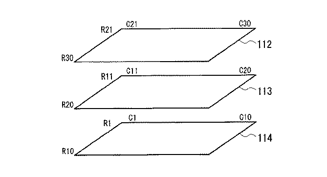
図4は、ここまでの処理で記憶された地図画面データー112、緯度経度2次元配列データー113、アドレス2次元配列データー114の対応づけを示す。図4の3つの平面は2次元配列の格納領域を表し、3つの平面の上下に対応する位置、例えば、(R1,C1)、(R11,C11)、(R21,C21)は地図上で同じ位置の地図画面データー、緯度経度データー、アドレスデーターである。緯度経度2次元配列データー113における格納番地のRowインデックス及びColumnインデックスにそれぞれ10づつ加算すると、地図上で同じ位置の地図画面データーの格納番地となる。同様に、緯度経度2次元配列データー113における格納番地のRowインデックス及びColumnインデックスからそれぞれ10づつ減算すると、地図上で同じ位置のアドレスデーターの格納番地となる。
以上の処理で、位置情報端末100のLCD表示パネル104に、地図、現在位置、アドレスを表示するために必要なデーターが位置情報端末100内に記憶される。
FIG. 4 shows the correspondence of the
With the above processing, data necessary for displaying the map, the current position, and the address is stored in the
次に、図5を参照して、位置情報端末100が、LCD表示パネル104に表示された地図上に現在位置及びアドレスを表示する処理の流れを説明する。
コントローラー106は、GPSモジュール105から自己の現在位置を示す緯度経度データーを読み出し(ステップS21)、読み出された緯度経度データーをRow Columnアドレスデコーダー109へ入力する。Row Columnアドレスデコーダー109は入力された緯度経度データーに対応するRow値及びColumn値を出力する。出力されたRow値及びColumn値を記憶装置108のRowレジスター115、Columnレジスター116に記憶する(ステップS22)。
次に、コントローラー106は、Rowレジスター115、Columnレジスター116の値をもとに、地図画面データー112における格納番地を算出する(ステップS23)。Rowレジスター115、Columnレジスター116の値は、Row Columnアドレスデコーダー109に緯度経度データーを入力して取得した値であるので、上記で説明したように、この値は緯度経度2次元配列データー113における格納番地を表す。この格納番地の各インデックスに10づつ加算すれば、地図画面データー112における格納番地を算出することができる。
コントローラー106は、地図画面データー112の内容をLCD表示パネル104に表示し、さらに、LCD表示パネル104に、上記で算出された地図画面データー112における格納番地に対応する位置に、図6に示すように自己現在位置マーク121を表示する(ステップS24)。
Next, with reference to FIG. 5, the flow of processing in which the
The
Next, the
The
次に、コントローラー106は、Rowレジスター115、Columnレジスター116の値をもとに、アドレス2次元配列データー114における格納番地を算出する(ステップS25)。上記と同様に、Rowレジスター115、Columnレジスター116の値は緯度経度2次元配列データー113における格納番地を表すので、アドレス2次元配列データー114における格納番地は、緯度経度2次元配列データー113における格納番地の各インデックスから10づつ減算して算出することができる。アドレス2次元配列データー114において、算出された格納番地のデーターを取得し、図6に示すように現在位置アドレス表示122をLCD表示パネル104に表示する(ステップS26)。
Next, the
なお、上記の実施形態においては、記憶装置108に2次元配列の領域を確保し、地図画面データー112を(R21,C21)から(R30,C30)、緯度経度2次元配列データー113を(R11,C11)から(R20,C20)、アドレス2次元配列データー114を(R1,C1)から(R10,C10)に格納したが、2次元配列のインデックスのとり方は上記に限定されない。緯度経度2次元配列データー113の格納番地のインデックスに基づいて地図画面データー112及びアドレス2次元配列データー114の格納番地のインデックスが算出でき、各格納番地が重複しないように確保すればよい。
In the above embodiment, a two-dimensional array area is secured in the
この発明は、GPS位置情報をもとに現在位置のアドレスをリアルタイムに表示する携帯電話やPDA等に用いられる。 The present invention is used in a mobile phone, a PDA, or the like that displays an address of the current position in real time based on GPS position information.
100…位置情報端末、101…携帯電話ブロック、102…携帯電話通信モジュール、103…キーボード、104…LCD表示パネル、105…GPSモジュール、106…コントローラー、107…制御プログラムROM、108…記憶装置、109…Row Columnアドレスデコーダー、111…データーバス、112…地図画面データー、113…緯度経度2次元配列データー、114…アドレス2次元配列データー、115…Rowレジスター、116…Columnレジスター、120…地図、121…自己現在位置マーク、122…現在位置アドレス表示、200…位置情報基地局、201…データーサーバー、202…地図データー、203…緯度経度データー、204…アドレスデーター、205…通信制御部、300…通信ネットワーク
DESCRIPTION OF
Claims (3)
前記位置情報基地局は、
地図データー、前記地図データーに対応づけられた緯度経度データー及びアドレスデーターを記憶する記憶手段と、
前記位置情報端末からの要求に対して、前記地図データーのうち指定範囲のデーターと、前記指定範囲のデーターに対応づけられた範囲の緯度経度データー及びアドレスデーターとを抽出する抽出手段と、
前記抽出した地図データー、緯度経度データー及びアドレスデーターを前記位置情報端末へ送信する送信手段とを備え、
前記位置情報端末は、
前記GPS受信機から取得した現在位置の緯度経度を前記位置情報基地局へ送信し、範囲を指定して前記地図データー、緯度経度データー及びアドレスデーターを要求する要求手段と、
前記位置情報基地局から取得した地図データー、緯度経度データー及びアドレスデーターを対応づけて記憶する記憶手段と、
前記GPS受信機から取得した緯度経度に対応するアドレスを、前記アドレスデーターから抽出して前記地図データーと共に表示する表示手段とを備えることを特徴とするGPS位置情報のアドレス表示システム。 In an address display system for GPS location information in which a location information terminal including a GPS receiver and a location information base station are connected via a communication network,
The location information base station is
Storage means for storing map data, latitude / longitude data and address data associated with the map data;
In response to the request from the location information terminal, extraction means for extracting data in a specified range of the map data, and latitude / longitude data and address data in a range associated with the data in the specified range;
Transmitting means for transmitting the extracted map data, latitude / longitude data and address data to the location information terminal;
The location information terminal
Request means for transmitting the latitude and longitude of the current position acquired from the GPS receiver to the position information base station, and requesting the map data, latitude / longitude data and address data by designating a range;
Storage means for storing map data, latitude / longitude data and address data acquired from the location information base station in association with each other;
An address display system for GPS position information, comprising: display means for extracting an address corresponding to the latitude and longitude acquired from the GPS receiver from the address data and displaying it together with the map data.
The display means stores a correspondence relationship between the index of the two-dimensional array storing the latitude / longitude data and the stored latitude / longitude value, and the GPS reception is performed in the two-dimensional array based on the correspondence relationship. The address display system for GPS position information according to claim 2, wherein a storage address of an address corresponding to the latitude and longitude of the current position acquired from the machine is specified.
Priority Applications (1)
| Application Number | Priority Date | Filing Date | Title |
|---|---|---|---|
| JP2004269770A JP2006086833A (en) | 2004-09-16 | 2004-09-16 | Address display system of gps positional information |
Applications Claiming Priority (1)
| Application Number | Priority Date | Filing Date | Title |
|---|---|---|---|
| JP2004269770A JP2006086833A (en) | 2004-09-16 | 2004-09-16 | Address display system of gps positional information |
Publications (1)
| Publication Number | Publication Date |
|---|---|
| JP2006086833A true JP2006086833A (en) | 2006-03-30 |
Family
ID=36164971
Family Applications (1)
| Application Number | Title | Priority Date | Filing Date |
|---|---|---|---|
| JP2004269770A Withdrawn JP2006086833A (en) | 2004-09-16 | 2004-09-16 | Address display system of gps positional information |
Country Status (1)
| Country | Link |
|---|---|
| JP (1) | JP2006086833A (en) |
Cited By (3)
| Publication number | Priority date | Publication date | Assignee | Title |
|---|---|---|---|---|
| JP2008164436A (en) * | 2006-12-28 | 2008-07-17 | Casio Comput Co Ltd | GPS receiver |
| US7912636B2 (en) | 2006-12-08 | 2011-03-22 | Denso Corporation | Apparatus and program for navigation |
| JP2016149156A (en) * | 2008-10-01 | 2016-08-18 | ヘレ グローバル ベスローテン フェンノートシャップHERE Global B.V. | Spatial index for locating geographic data parcel stored on physical storage media |
-
2004
- 2004-09-16 JP JP2004269770A patent/JP2006086833A/en not_active Withdrawn
Cited By (3)
| Publication number | Priority date | Publication date | Assignee | Title |
|---|---|---|---|---|
| US7912636B2 (en) | 2006-12-08 | 2011-03-22 | Denso Corporation | Apparatus and program for navigation |
| JP2008164436A (en) * | 2006-12-28 | 2008-07-17 | Casio Comput Co Ltd | GPS receiver |
| JP2016149156A (en) * | 2008-10-01 | 2016-08-18 | ヘレ グローバル ベスローテン フェンノートシャップHERE Global B.V. | Spatial index for locating geographic data parcel stored on physical storage media |
Similar Documents
| Publication | Publication Date | Title |
|---|---|---|
| JP4198513B2 (en) | MAP INFORMATION PROCESSING DEVICE, MAP INFORMATION PROCESSING SYSTEM, POSITION INFORMATION DISPLAY DEVICE, ITS METHOD, ITS PROGRAM, AND RECORDING MEDIUM CONTAINING THE PROGRAM | |
| JP6353199B2 (en) | Information processing apparatus, information processing method, and program | |
| KR102050956B1 (en) | The POI highlight system and method of navigation through the analysis of user behavior patterns | |
| CN102023289B (en) | Electronic device and map display method | |
| JP2004062688A (en) | Information providing system based on position information, information providing device, and information acquisition device | |
| JP2006221351A (en) | Balance inquiry device and program | |
| JP2013160586A (en) | Navigation device | |
| KR100676619B1 (en) | Location memory mobile terminal, location memory service system and method using the same | |
| JP2006086833A (en) | Address display system of gps positional information | |
| JP2015053002A (en) | Information presentation program and mobile communication terminal using the same | |
| WO2004099719A1 (en) | Method and system for providing map information to mobile device | |
| JP2013036748A (en) | Car navigation device, car navigation system, car navigation method, and car navigation program | |
| JP2012042339A (en) | Route guidance device, route guidance system and program | |
| KR100672390B1 (en) | Mobile communication terminal having a map creation function and a map creation method using the map | |
| JP5921972B2 (en) | Route guidance device, route guidance method, and computer program | |
| CN107146431A (en) | Wearable device and road condition information updating method for wearable device | |
| JP2008082818A (en) | Navigation system and navigation device | |
| JP2006078298A (en) | System and method for displaying map information | |
| JP2005049189A (en) | Navigation system, navigation system information terminal and information center | |
| JP2004301525A (en) | Navigation system | |
| JP5426455B2 (en) | Map image generating apparatus and program | |
| JPWO2009078106A1 (en) | Image display device, image display method, and program for image display device | |
| KR100946366B1 (en) | GPS based route guidance system | |
| JP2003141406A (en) | Electronic coupon issuing system | |
| JP2007212185A (en) | Map information cooperation system |
Legal Events
| Date | Code | Title | Description |
|---|---|---|---|
| A621 | Written request for application examination |
Free format text: JAPANESE INTERMEDIATE CODE: A621 Effective date: 20070720 |
|
| A761 | Written withdrawal of application |
Free format text: JAPANESE INTERMEDIATE CODE: A761 Effective date: 20090128 |